
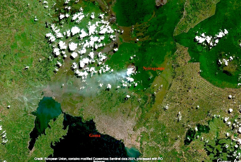
Few people would have heard of Mount Nyiragongo before its current eruption. There are some cities that we know live in the shadow of a volcano. Naples and Vesuvius, Catania and Etna, Seattle and Rainier (although the city itself is unlikely be affected by an eruption), Fuji and Tokyo (with the same proviso). But Nyiragongo is worse than any of these. It erupts often (the current eruption is number 35 since 1882). The effusive lava is very fluid and moves fast. Worse, the mountain is extremely steep for this type of eruptions, reaching 50 degrees near the summit. The lava flow can reach speeds approaching 100 km/h. And the city of Goma, with half a million people, lies directly in one of the paths the flows can take. Finally, this is in the DRC, perhaps the country worst equipped to deal with volcanic risks. Both the 1977 and 2002 flank eruptions had a significant number of fatalities in Goma. In 2002, 13% of the city was covered by 2-meter thick lava as it flowed towards Lake Kivu. And fatalities continued long after the eruption had ended.
Since 1970, there have been 25 volcanic eruptions worldwide with fatalities. By far the worst was Nevado del Ruiz, where 23,000 people died. Second is El Chichon, followed by Pinatubo, Anak Krakatau and Merapi. (In my opinion, Kazbek should be added to the list.) Nyiragonga was already the only volcano to appear in this list twice, with both appearances among the 10 worst eruptions of the past 50 years. And now it is in this list 3 times.
(The number of eruptions worldwide with fatalities has increased dramatically in recent years. Since 2010, there has been on average one such event per year. Before that it was much less. In two cases tourism was involved, but the others were people living in the wrong place. With volcanoes, precaution is the only effective strategy.)

People crossing the hot lava on foot, the day after the 2002 eruption. Many burn wounds resulted. Heavy rain a few weeks later caused dense fog and gas, which led to further fatalities. Luckily the 2021 eruption was in the dry season
We often discuss the dangers of explosive eruptions, and point at Krakatau, Tambora or El Chicohn. Those kinds of eruptions are huge, devastating, and unpredictable. Often the culprit was not recognized as dangerous prior to the explosion. Effusive eruptions are more sedate, tourist-friendly, and predictable but also more frequent. We acknowledge the damage they can still do, and the desperation of people seeing their home engulfed by lava. There is no such thing as a friendly volcano. But Goma finds itself in the worst of both worlds. Its mountain suffers frequent effusive eruptions which come fast and without warning, and are as deadly as explosive eruptions would be. And it is not only the lava. The gas emissions cause acid rain which can damage plant and tree growth on the mountain. Near the crater rim, underneath the volcanic plume, the rain can have pH as low as 2. Low pH and high fluoride has been measured as far as the village of Rusayo, 10 km from the summit.
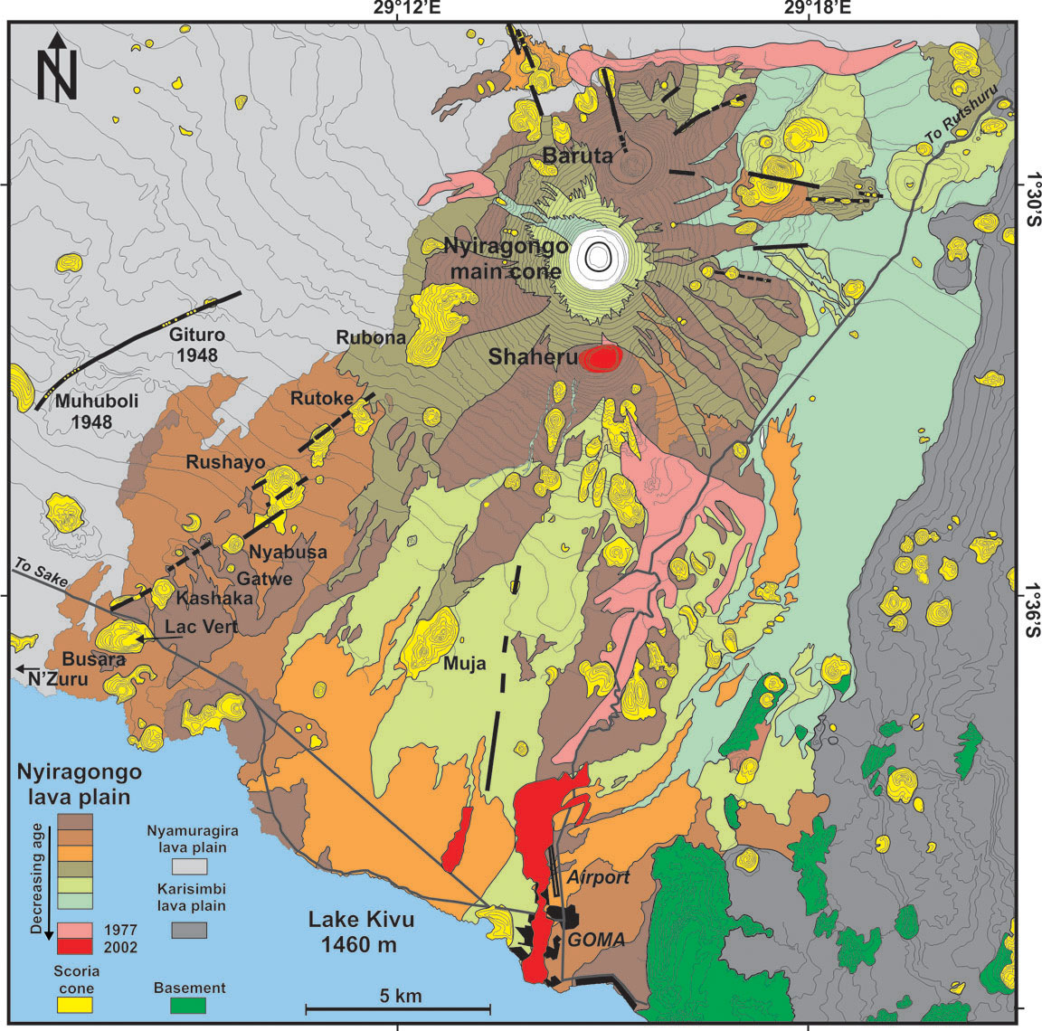
Geologically, Nyiragongo is part of a cluster of volcanoes, two of which remain active. Together they form the Virunga bulge, home of wonders including the impenetrable forest and its mountain gorillas. The bulge sits at the intersection of the Albertine rift (the western branch of the African rift, running north-south – the volcano, as well as Goma and Lake Kiva are located in the rift), and the Kamatemba rift (running northwest to southeast into the Albertine rift). Exactly what feeds the volcanoes is being studied, but a crossing of two rift indicates this is a weak spot. Two magma chambers are suspected, one shallow and one 14 km deep.
The unusual lava of Nyiragongo is attributed to a melting of a carbonated mantle. It differs from all other lavas in Virunga. This seems related to the depth: its magma formed from a much deeper melt than elsewhere in the Virungas. The lava is often claimed to have the lowest viscosity of any volcano known but this is disputed. It is fluid, but the extreme speed of the lava is caused mainly by the steepness of the cone.
The steep cone is not what one would expect from low viscosity lava. It should have build a very broad shield, not a cone. The mountain cannot have been build by these lava flows. There are several possibilities. There may have been a very recent change in the magma. But none of the lavas seen in this area can build such a steep cone. The second possibility is that the mountain was not build from the outside but from the inside. The mountain is in effect the sides of the conduit. Magma rises, forms a lava lake, and the lava lake solidifies against the sides and adds bulk to the mountain. The magma builds the mountain around it. Because this builds the mountain with solidified rather than liquid rock, it can be much steeper than flowing lava would allow. The lava lake has several benches: these benches are how the mountain grows.
The 1.2-km wide, deep crater of Nyiragongo hosts the largest lava lake in the world, some 200 meters wide. The mountain is 3470 meters tall; the lava lake is typically at a height of 2700-3000 meters, while Lake Kivu is at 1470 meters. You can imagine the stress that the sides of the mountain are under! It carries a 1-km wide bucket of lava at the narrow tip of a steep cone. The sides of Nyiragongo are indeed riddled with rifts, many of which are unmapped because of the dense vegetation. These rifts can feed the eruptions, as they did in 1977 and 2002, and apparently also in 2021.

The volcano is about 12,000 years old; the current deep crater is though to have formed a few hundred years ago through caldera collapse. There have been previous collapses: there are two other but extinct craters of similar size, one located two kilometers north (Baruta: visible on the image) and one 2 kilometer south of the current crater (Shaheru). The three cratered cones are aligned: there seems to be a short north-south rift underneath Nyiragongo. This rift follows the direction of the Albertine rift and therefore may have benefited from spreading in the Albertine. In contrast, the Virunga volcanoes overall follow an east-west line. Although the parasitic cones are themselves extinct, they are not immune. During the 1977 eruption, lava erupted inside Shaheru crater.

The flows and source of the 2021 eruption. Click on the image for full resolution. Sentinel image from June 2020
The 1977 eruption formed a rift just above the Shaheru crater; lava flowed into this crater. The 2002 eruption showed lava fountaining above Shaheru from the same fracture. But the 2002 eruption extended this rift much further. The southern flank of Shaheru was ruptured in two places, 300 meters apart. The rift extended downward towards Goma, causing small grabens with lava fountains in several place along the way. These fissures reached the city itself.
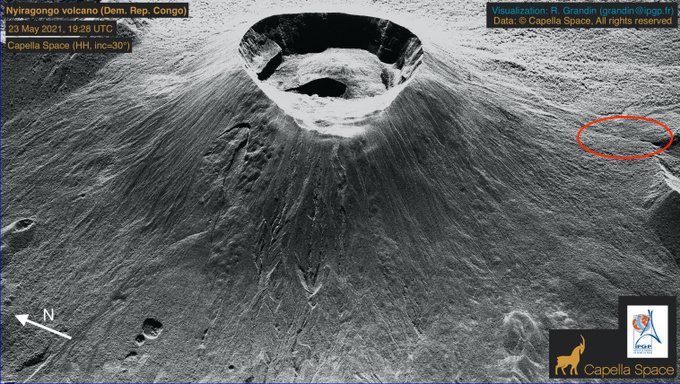
Capella radar image of Nyiragongo (https://twitter.com/RaphaelGrandin/status/1396948118067888128). The rift that was active in the 1977 and 2002 eruptions is indicated by the oval.
The 2021 eruption appeared to have started just southeast of the Shaheru crater, close to previous flows. The lava appear to have come through the same fissure as in 1977. The flow split in two, with the longest one heading south, ending within the Goma suburbs close to the airport runway. In the day after the eruption, Goma was hit by several earthquakes which caused cracks in roads. This seems to have extended the activity of 2002, when minor rifting and gas emission was seen 500 meters beyond the lava flows, as far as the airport. In 2021 it reached just off-shore into Lake Kivu. A long crack in the N2 road parallel to the coast also suggests some ground movement within the lake. The rift has thus progressed from 1997 when it formed as 2-kilometer long fracture, to 2002 when it extended by 15 kilometer, to 2021 when it added a further kilometer. Note that this does not mean it is exactly the same crack. Rifts have a certain width and the new crack may be next to and parallel to the previous one.
The eruptions are fed not from a magma chamber but from the existing lava lake. This means there is little or no tremor preceding the eruption as there is no rising magma. Instead, they start when the growing pressure of the lava lake breaks through the steep sides of the cone (a fate the Geldingadalir walls are trying to avoid), involving tectonic earthquakes. In 2002, the eruption was preceded by an M4 earthquake two weeks earlier. This earthquake may be when the break first began to form. The 2021 eruption did not have a clear precursor earthquake. (An earlier claim in this post for a precursor earthquake was based on an erroneous location.) The aftermath is also the same. In 2002 there was earthquake activity on a line between Goma and Nyiragongo for 5 days after the eruption, with the strongest even M5, and in 2021 there were several earthquakes in the day after the eruption also peaking at M5. This pattern adds some predictability to the Nyiragongo eruptions.
But this expanding rifting activity points to another major danger, beyond that of an eruption in the heart of the city. This mountain seems unstable. The rifts in the side are integral to the mountain (that can be seen because many of them directly feed volcanic gasses into the water system). There could be a failure where two of the side rifts combine and one side of the mountain slides down-hill. Such an event would be catastrophic. Most volcanoes in the Virungas show no evidence for a flank failure, but the extinct Mount Sabyinyo does have a big gap in its side and on satellite mages a 1-km wide crater, 2 km southeast of Mount Karimbi also seems to have a gap on the side facing away from Karimbi.
But let’s look at Goma itself. Why build a major city in a place where it has been hit by lava streams three times in the past 50 years?
Goma is at the border with Rwanda. Gisyeni, the part of Goma on the Rwandan side is well connected to the Rwandan capital, Kigali. Travel in the DRC can be more difficult. The area is very densely populated, fertile, with mild tropical climate. The Rwandan genocide in 1994 caused many refugees to flee to Goma, with rebel movements following. The area has remained rebellious and it is not always under control of the central government. People are attracted by the mineral wealth of the DRC. This should be a fabulously wealthy country. Instead, the wealth goes to however manages to profit most. Some of the rebels have a cause. Others just want the wealth for themselves. And earlier this year, the Italian ambassador (who also helped to run the world food program here) was killed by rebels, in a kidnap that went wrong.
And in spite of the insecurity, Goma has grown rapidly. The current population is estimated at 670,000, growing at 5% per year. It is now three times the size it was during the devastating 2002 eruption, and ten times that during the 1977 eruption! New roads have been build (many by Chinese contractors), on top of the 2002 lava.
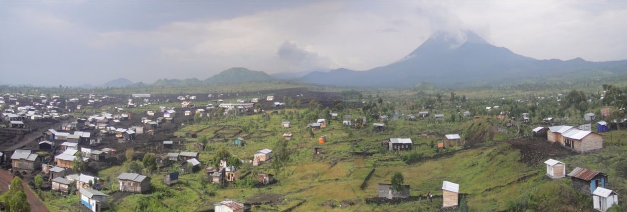
In view of such unstoppable growth, where do people live? They can’t go east, towards Rwanda, as Gisenyi is too small and itself has no room to expand. West gives some space but quickly takes them out of the rift valley. South lies the lake. So the city grows west along the lake shore, and north on the plains leading to the Virunga mountains. Much of the land is already taken, and so people build houses where they find unoccupied space. People have to get to work, using the taxis, any ride they can get, or by walking. So they live near the roads. Conveniently, there is space here which is not farmed or otherwise occupied. That is, they build their houses on top of the recent lava flows.
A time line shows the growth of Goma. The image below is from 2005, when the 2002 lava flows are still visible.

Goma, 2005
The most recent image, from 2019, shows dramatic changes.
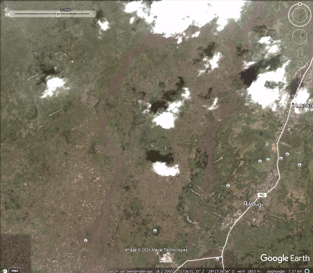
Goma, 2019. Click on the image or here to see a timeline
Putting the Google earth images together (thanks Gijs, Lughduniense!) shows the rapid expansion in a time line of Goma’s growth towards Nyiaragongo..
As you can see, the expansion of the city follows the 2002 lava flows very well, along the roads build on those flows.
But the lava flowed along those paths for a reason. Nyiragongo can erupt in all directions, but in the three major eruptions of the past 50 years the lava has gone south, following the underlying north-south weakness in the mountain. This rift formed in 1977 eruption, was re-activated in 2002 and possibly again in 2021, extending through the city and now into the lake. The rift provides a pathway for the lava which inevitably ends up in the same area as before, following very similar flow paths towards the lowest points. The people are living on a ticking time bomb.
They do so not by choice, but because they too have to live. These are not refugee camps, put wherever others can’t see their plight. They need houses to live and places to work. They are people just like us.
And now Nyiragongo has erupted again. The precursors were too weak to be seen on the few available instruments and by the few scientists. Do not expect magma signals: the lava is already in situ and all it needs is to break through the crater wall. The precursor was probably a faint tectonic signal. People knew that a new eruption was imminent. The lava lake had grown too big. But they did not know when. Suddenly the sky went red and the lava came. Eruptions of Nyiragongo only last a few hours. By the time the alarm was raised and the evacuations had started, the lava was already among the people. We do not know yet how many casualties there were. So far, 500 houses are reported buried, 23 people died from the eruption and 9 from a big traffic accident in the evacuation. The real toll will be higher and may never be known.
Proposals have been made to safeguard Goma. Dams could be build to divert the lava around the most endangered area in east Goma. The problem is that this would divert the lava towards other areas that are just as densely populated. Warning systems have been proposed, already 25 years ago. But hardware on the ground does not last long, often due to theft. Before the 2002 eruption, only 2 of 5 installed seismographs were still working. The rangers who lead the expeditions to the lava lake do report anything unusual – but it needs people to collate and analyse the reports. The 2002 eruption has been predicted in advance by the local scientists, based on reports from the rangers and the little instruments they had. There was failure of action on these warning by the authorities – who in any case do not carry much authority here. The 2021 eruption was expected but was not predicted.
What can be done? Monitoring from space is difficult because of the near-perpetual cloud cover over the peaks. Seismographs could be placed in Rwanda, not many kilometers away. But that is a different country and they cannot issue warnings for Goma. With such a volcano, an eruption warning needs to be instantaneous (in 2002 lava reached Goma within 20 minutes, and because the rifts extends into the city the eruption could in theory begin within the city limits), and should be unmissable. It can be done – even here, most people have mobile phones. Pre-eruption warnings need to be accurate, otherwise they will quickly be ignored. That requires significant scientific effort. And finally, we need predictions where lava is most likely to flow, and discourage people from living there. East Goma in particular should not be there. That may be the hardest task of all.
Goma was lucky this time. But there will be a next time. And one after that. And one day this could become the Pompeii of the tropics.
Albert, May 2021
Addendum 27 May 2021
A new INSAR image has appeared show ing spectacular changes in the rift valley. The image shows the changes between 19 and 25 May (i.e. including the eruption but not the subsequent tectonic activity). It is reproduced here (at reduced resolution), with the original taken from https://pbs.twimg.com/media/E2U9GXEWEAU55XF. The INSAR data is also available from https://sarviews-hazards.alaska.edu/Event/221?pinned=d989972a-8f8e-4337-9744-f9dbb668ef33,406295fb-403e-4604-acc9-4cd65ddeae09
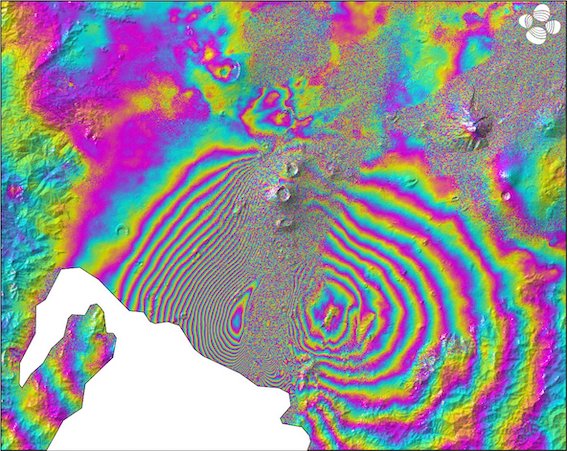
Sentinel INSAR data, 19-25 May 2021
This looks very much like a dike intrusion but there are two aspects worth noticing. First, the coloured contours are best visible along the side of the rift valley. Second, the colour sequence on the left and the right of the valley are reversed (look for the order yellow-green). It is always hard to separate up/down from left/right in these plots (the satellite measures the distance from the satellite to the ground, and if it is not directly overhead it will see both). The reversal suggests that the sides of the rift valley are moving away (or towards) from each other, i.e. rifting. If they were moving up (or down) you would see the same pattern on both sides.
So there is rifting. But there is not much indication for a large dike. That would show up as inflation in the centre and that is not really seen. (Unless it is localized in the feature near the lake coast which coincides with a ridge in the landscape).
We will wait for more data. I think there is rifting between Shaheru and Goma. Whether there is lava inside the rift remains to be seen.


It’s official. Kilauea is no longer erupting. From the HVO:
“Kilauea Volcano is no longer erupting. Lava supply to the Halemaʻumaʻu lava lake has ceased and sulfur dioxide emissions have decreased to near pre-eruption background levels.
Accordingly, the USGS Hawaiian Volcano Observatory (HVO) is lowering the Volcano Alert Level for ground based hazards from WATCH to ADVISORY and the Aviation Color Code from ORANGE to YELLOW.
HVO continues to closely monitor Kīlauea Volcano for signs of renewed activity. Should volcanic activity change significantly a new Volcanic Activity Notice will be issued.
Hazards are still present on Kīlauea Volcano and are described below. Residents and visitors should stay informed and follow County of Hawai‘i and Hawaiʻi Volcanoes National Park guidelines.”
It will come back soon .. with souch large magma supply .. perhaps in form of a powerful ring fault eruption l
If it comes back as a ring fault eruption then that is a big deal, massive new magma pulse from depth to drive something like that. Would likely have the same outcome as 1959 in driving a large scale eruption on the lower section of the rift instead of erupting out of the summit.
I expect the next eruption to be probably in Halemaumau again, but it will probably be pretty different to most as the vent could be deep underneath the new lava. This eruption is one of the biggest summit eruptions at Kilauea historically, only 1967 was bigger but lasted twice as long, and the lava lake depth is not even close to being matched by any other eruption, 1959 was only half as deep.
If a vent opens above the lake though its probably going to keep erupting until the crater fills to that level, if it erupts under the lake it will probably turn into a sustained lake again but that brings an increased risk of a major sudden eruption on the flank with all the hydraulic head suddenly at play. The fact that inflation of the magma system began basically as soon as the major vent of this eruption stopped in December even with continued effusion shows the supply is high, probably in a normal situation only the big north vent would have stayed active past the initial few hours and been much weaker by one day in but all the vents stayed active to the point they got drowned and they were all erupting still on the second day at just as high intensity as the start. I dont expect a long pause.
more Sentinel 1 interpretation for Goma.
https://twitter.com/j_p_joule/status/1398611053274087425?s=20
Any magma involved in this ?
nothing is mentioned in his thread (besides the mechanics why dyke could show as subsidence).
if being blind is unnerving for us it is probably very stressful for the authorities in Goma / Giseniy.
It looks like rifting, why an intrusion would appear to be subsidence.
Or maybe I’m wrong.
https://www.instagram.com/p/CPdRZg6nrSs/?utm_medium=copy_link
Overflight over Nyiragongo
Looks like its totaly caved in the lava lake and crater is totaly drained
Anyone wanting to build their own 3D model of Mars? Well you’re in luck as NASA just added Ingenuity’s navcam and colour camera raw images to the Perseverance raw image server. 🙂
https://twitter.com/NASAJPL/status/1398398787597398016
Here’s a user processed image by Thomas Appéré on Flickr to level up and correct for wide angle lens.
Thomas Appéré
Ingenuity looks west – sol 91
“Picture taken by RTE camera aboard Ingenuity helicopter on sol 91 (22 May 2021). The helicopter was flying at an altitude of 10 meters. Sky extended on post-processing.”
Link to Thomas Appéré flickr https://www.flickr.com/photos/thomasappere/
I let gimp do the automatic color balance on the picture – https://drive.google.com/file/d/1m4SlTxLG-QxkfvcXVUaFQ0jbpXY6Z_QN/view?usp=sharing
It is quite nice to see the blue sky here.
Its beautiful! I want to walk there…..
And the contrast enhancement certainly helps things stand out!
😂
On the Langihryggur camera, the top of the western wall shows heat signals: one or two brief flashes, smoke, one twirl. I would think it is getting closer to overtopping.
I’ve studied that piece of yours about the Eye of Africa that you put a link to further up a second time and it might not be the last time. It struck me afterwards that the Capella Radar Pic of Nyiragongo bears some similarity to a Nova. And if this is correct, the Richat Structure might have been a gigantic stratovolcano once. Might.
This 4 km deep trench around the Artemis Corona is a striking and puzzling feature (Trench without water seems strange).
Hi Albert despite being so extremely fluid as Nyiragongo can be there is almost a complete lack of peles hairs .. Halemaumaus lava lakes very fluid lavas made these in huge ammounts, But Nyiragongo did not.
Perhaps its the incredible low sillica content that makes Nyiragongo lavas unsuitable for Peles Hairs .. despite the low viscosity .. too little polymerisation
2021-05-29: Current seismicity and ground deformation data continue to indicate the presence of magma under the urban area of Goma with an extension under Lake Kivu. Seismicity and deformation continue. The number of earthquakes detected in 24 hours decreases slightly, as do the deformation rates. However, this decrease in the phenomenology at this stage cannot yet be interpreted as the end of activity. During phases of volcanic activity, periods of higher seismic activity often alternate with phases of lower seismicity. seismic activity often alternate with phases of lower seismicity. Seismicity above the baseline is always recorded. These observations are always consistent with the presence of magma at depth. Ash fallout may occur as a result of the collapse of parts within the crater. The data on the stability of Lake Kivu do not currently show any significant The stability data for Lake Kivu do not currently show any significant change (the latest available data is from 27 May 2021).
https://georiska.africamuseum.be/en/news/nyiragongo_eruption
I was thinking that Icelandic weather is unfairly taken to be a tad wet and windy for much of the time, given recent viewing conditions since this eruption started.
I fear Skadi has returned.
PS Looking up the nordic god of bad weather/winter I was amused to see many consider scandinavia is named after the nordic giantess Skadi.
It’s fairly typical. In the south western corner of Iceland May is often sunny and dry, while June tends to be a bit more warm, and often quite rainy. There are no guarantees though, anything can happen.
I’m tabling a motion of no confidence in the Icelandic weather gods. They’re just too unreliable. I’ve petitioned for clear viewing weather on several occasions and had no response, even when offering substantial sacrifices. I only found an anonymous note in my inbox saying “You don’t have any sheep and you don’t know any virgins.”
Weather has cleared as of 17.19 GMT, but the camera isn’t currently showing the state of the West Wall. Very steamy landscape.
Nova, volcano under the city, 2014, is an interesting video, it wasn’t the original, which I posted many years ago, but ok, there is a video i found in the middle of the night , with lake Kivu on fire and heaps of blck smoke. only picks of cracks ect available now
https://twitter.com/justusronaldBO/status/1398983699337732099
There were 92 #earthquakes and tremors recorded in the past 24 hours around the Mount #Nyiragongo #volcano in the Democratic Republic of the #Congo, according to a government official #Goma
There is a detailed report and map of East african rift by USGS back from 2013.
https://pubs.usgs.gov/of/2010/1083/p/pdf/ofr2010-1083p.pdf
The map shows an active volcano in Sudan, which in turn seems to be partially attributed to Central African Shear Zone.
The maps on https://en.wikipedia.org/wiki/Central_African_Shear_Zone shows rifts
https://en.wikipedia.org/wiki/Central_African_Shear_Zone#/media/File:Central_African_Rifts.svg
Those rifts are perpendicular to East african rift! Also, on maps of EAR there is no mention of Sudan / Kenya rifts, and vice versa. Can they mean some other “rift”? This is leaving me well confused.
From your link: “The structure is not well understood. As of 2008, there was still no general agreement about how the individual shears along the lineament link up.” Which means you’re not alone. It goes on to the Foumban Shear Zone, or Central Cameroon Shear Zone (CCSZ) and then to the Pernambuco Fault in Brazil.
It is at least 640 My old and was rejuvenated several times later in Jurassic and Cretacious (probably also Triassic then). It’s horizontal, think Gondwana.
If you look at the pictures on wiki you will find rifts from Kenya’s Lamu embayment to Abu Gabra Rift in Sudan. Pretty much perpendicular to EAR.
Sunday
30.05.2021 13:58:50 63.960 -21.763 7.4 km 2.9 99.0 6.2 km WSW of Bláfjallaskáli
The wall still holds. There are glimpses through the rain if you look on the youtube Langihryggur camera.
Unfortunately I can only give live minus which isn’t much help.
Thank you for the update! I just looked but could not see much other than normal UK (sorry, Icelandic) weather on the cameras.
We’ll have to ask Gutn Tog to take a walk out for us. 🙂
The wall is still standing at 17.44 UK time, but there does seem to be some hot stuff at the base of it, judging by the fact there seems to be steam coming up from down there. The whole landscape’s steaming, in fact – quite spectacular.
Kind of odd; the biggest steamy bit at the bottom of the dam towards the west seems to be steaming harder/getting bigger. It’s not possible for the lava to have burrowed under or through the dam, is it?
I saw that. It has been there for some time. Is it steam or an instrument? If steam, it is most likely water going down the inside of the dam, heated by the lava and then finding a flow hole through the bottom out the other end. But this is a guess. A zoom-in will tell us, I hope.
Columnar jointing in melilite-Nephelinite from the Southern Balcones volcanic and intrusive rocks in Texas. Nyiragongo lavas can be found in a few other outcrops in the world as well as the Late Stage Oahu lavas
Now for real: the neck/saddle leading to observation hill is about to overflow. The path has been cordeoned of and a patch of lighter lava is collecting…
https://imgur.com/hk95Ml6
It’s official, the hill is evacuated and the lava is expected to surround it today or tomorrow, making it “an uncircumcised islet” according to giggle translate.
Source https://www.mbl.is/frettir/innlent/2021/05/30/ryma_utsynishol_svo_folk_verdi_ekki_innlyksa/
And when it overflows, the western wall is next…
faulty link removed – admin
failed image copy removed – admin
Tried to copy an image but sadly failed.
If there is another overspill into the nameless valley from the west then there are two ways in and three ways out one of which to the SW is blocked by a dam.
As the breached SE exit is by now lower than the dammed SW it is very unlikely that the new lava flow from the west will exit there. It’ll carry on flowing to the SE and exit at that point.
I’m inclined to believe now that the SW dam will never be breached in this eruption unless a new vent opens,
That is possible. The lava is at the very top of the dam though and any increase in lava level will cause it to overflow
Mostly a decenct English translation is way les annoying than what I get here in some robocopapparentlysupposedlydutchlikebabberish. 😂
Direct… Auto correct is getting annoying as well.
No more spectator hill for visitors:
Benjamin Hennig@geoviews:
It looks as if the prime seats for viewing the #Geldingadalir volcano are about to be closed for good. Lava is now fast approaching the popular ‘viewing hill’ which means that the closest spots for a safe view will be cut off & become inaccessible https://mbl.is/frettir/innlent/2021/05/30/ryma_utsynishol_svo_folk_verdi_ekki_innlyksa/
#iceland
https://twitter.com/geoviews/status/1399105084575956993?s=20
I guess we’re just gonna have to have another vent then….
🙂
This link was posted on Tokolosh’s chat, shows the saddle is very close to being overrun (use the divider)
https://cdn.knightlab.com/libs/juxtapose/latest/embed/index.html?uid=dc4453f8-c17a-11eb-b7bf-95443c729a29
This might be useful to get an impression of African shear zones CARS/CASZ/STARZ:
https://reconafrica.com/wp-content/uploads/Cross-Africa-Shear-Zones.pdf
An Ijolite… This is the plutonic version of a Nephelinite thats the extrusive lava form.. both of these contains around 36% sillica. Ultrabasic plutonic rock. Nyiragongos magma chamber complex is probaly encased in Ijolite complexes. Perhaps a window into Nyiragongos depths, more about that in next VC article I think. Ijolite is rare rare rock for soure
One of these very very rare magmatic rocks that I wants in my collection …
”Roots of Nyiragongo” its eruptive rocks are Nephelinites
Ijolite can be found in a superalkaline complex north of me here: so time to go and stone hunting then …
Another superare ultrabasic alkaline rock is called ”Urtite”mostly consists of nepheline minerals ..Probaly from settled crystals thats snowed into a magma chamber bottom
Have you heard of the Tucson Gem and Mineral show?
I want to go there but am afraid I will spend too much money on rocks.
http://www.tgms.org/show
https://actualite.cd/2021/05/30/rdc-une-camera-est-placee-dans-le-cratere-du-nyiragongo-afin-de-permettre-un-bon-suivi
RDC: une caméra est placée dans le cratère du Nyiragongo afin de permettre un bon suivi de l’évolution du volcan
They going to place a webcamera on Nyiragongos crater rim! I hopes there will be a link for it .. when its setup
A webcam sounds like a great idea, but……look at what’s happened to those seismometers! They’ll probably have to install it in a rather inaccessible part of the caldera where people can’t steal it.
Looks like the camera is already placed! is there a link to it ?
Well perhaps too expensive to have it over internet?
Beautyful video: crater interior collapses https://www.google.se/amp/s/amp.cnn.com/cnn/videos/world/2021/05/31/drc-congo-goma-mount-nyiragongo-madowo-lkl-intl-hnk-vpx.cnn
MikeK I have asked OVG s FB page If they will put it online for internet.. I hopes that .. we will see what they say
Lava’s getting closer to the neck:
Source for image: https://www.youtube.com/watch?v=BA-9QzIcr3c
That looks like quite a large, fresh outflow.
Gutn Tog put up a video at the lava front in the neck just a day or so ago, and that flat new area of lava did not exist! Things are changing quickly.
Something just went down by the cordon; suspect it was a person!
That was footage from a couple of days earlier.
They seem to be not very ambitious with the bulldozers any more. It would seem that, if there is an overflow there, a much larger fraction of the lava will end up in Natthangi instead of Meradalir. With an 8m or 12m barrier up there, this could be avoided potentially for a few weeks (based on how slow the level has been clingin on the NE side of the neck). Depending o how lucky they are with the distribution of lava being sent in the three different directions.
But more significantly, that could keep Theater hill operational for quite a while. Which would be good for the tourism industry 🙂
Dragons – if you find a half-broken comment in the dungeon, it’s mine. Please simply delete it! Thanks!
There may be a partially consumed packet of custard creams with it….. 🙂
A while ago, someone walked past the SW dam and onto the hill between the two dams.
Not long after a couple of high-viz clad people came running to bring him/her back onto safe land. I think with a new supply of lava about to enter the area, the dam would need to be treated as if it could fail at any time, and the authorities really don’t want anyone to be stranded in the middle there.
Ah, so that’s what was going on! I saw a guy with a dog cross under the W dam and take a walk, then I saw two more people (they looked on the camera to be in all white which I thought odd – hi-vis makes sense) running down the W hill and under the dam. I thought it was a stupid place to go for a run – so they were bringing back the dog guy.
Can’t quite make it out but there seems to be hi-vis tape cordoning off Theatre Hill, as there was to the east of the eruption after a week or so.
TV had an report from the Goma volcanic observatory. Plot showed an ominous alignment of small quakes which extended from Ny’ to beneath Lake Kivu. And, IIRC, ‘Limnic’ was mentioned, per those ‘incidents’ in Cameroon.
Catch, as most observers have mentioned, is that Nyos & Co were ‘mere’ crater lakes, but Kivu is a ‘rift lake’ and much, much bigger. Fifty-some cubic miles bigger. Apparently there is *some* methane extraction, used to power brewery etc on Rwandan side…
Another potential ‘gotcha’ is the Lake Nyos & Co. ’emanations’ from their turnovers swept down-hill from their crater and progressively dissipated. Lake Kivu’s low shores and their settlements are surrounded by higher ground, which may trap the deadly cloud…
Be NOT There.
Nyiragongo should have been on the NVDP series, either 1 or 2, it is terrifying how close this situation is to being one of the worst natural disasters we have ever experienced if a limnic eruption happens, there is a potential miltiple million death event that could happen overnight, with absolutely no warning at all, and where right now the likely mechanism to set it off is within the plausible outcome…
Mafic volcanoes need much more respect, We still regard to be in a volcanic drought since 1991 because there hasnt been anything above a low 5, but in that time we have seen Nyiragongo make the lethal factor twice and also two of the biggest lava eruptions in the last 300 years, one of them from the very place that granted the docile reputation…
Yes, but these limnic eruptions are very rare. The last one was 3,5 to 4k years ago. Albert does not expect this to happen as he said several times.
There is an island in the lake close to the Rwandan border. I don’t think people will leave it for a limnic eruption which might happen in the year 2525 as well. Their main problem seems to be the volcano and the quakes in town.
When I was a student everybody in the US talked about the San Andreas fault, and I said wrongly I wouldn’t live there. Then there was this Charlton Heston movie with LA collapsing. LA has other yearly issues: Mud slides. They collect them in a reservoir which they empty with trucks. Seems a bit primitive to me.
It is rare but it isnt as unlikely as any of the other events, and we dont have enough information to know the recurrence time. I dont think this will result in anything, it is tectonic rifting, but as we saw in Iceland this sort of activity is impossible to tell from a pre-eruptive swarm at this stage and one say there will be an eruption in Goma that will spell disaster, it isnt likely but it is there, it is preparation that matters.
How long till the lava goes over the neck? Or the other exit to Nátthagi?
Source: https://www.youtube.com/watch?v=BA-9QzIcr3c
I agree. I had a look in on the cam right now, and that lava front appears to be active and slowly extending into the saddle between the hills.
I get the feeling it may be a couple of days? There is quite a slope up to the path that is not very apparent on the video, but was more obvious on Gutn Tog’s recent video. So hence a delay yet.
Has Gutn Tog been given VC Honorary Dragon status yet? If not, how about “Official VC Hero” status? His videos have been beyond awesome, beyond even ewesome!
Gutn Tog’s video was taken on 25 May (published 27 May). Lava had risen 5m between that video and the one before it. He said, if I recall correctly, that the lava was 10 below the path on 25 May. So if the lava has maintained the same rate of rise, it would be very close to the path now.
Think the lava pond behind the front is higher than the front so a breakout may do it.
Lava front hasn’t moved at all since they zoomed in a few hours ago. Looks like the lava needs to climb at least another 2 meters before in can crawl across the ridge. My bet is at least 24 until the overflow, might even take a few days.
You may be right; even if it does not have to climb very far, the valley will be wider the higher you go so it would need more lava than first appeared.
It depends on many factors. Is there a tube feeding lava straight to the scene? Is the lava fluid enough for more to be injected and inflate the flow high enough for a break-out to get over the last little rise? Having pushed this far, will it now flow somewhere lower and easier?
We don’t know any of the answers, but it’s fun to watch and speculate.
I have to wonder how long it’s going to take for the Natthagi flow to reach the sea? With the eruption likely to go on for months or even years given the deep magma source, it’s possible. This means the local highway will certainly be blocked off if that happens, and the town of Grindavik may also be at risk. Fortunately, there’s more than one highway in and out of that town.
Looking at the existing example of Meradalir, it’s going to take a while, imho. The initial flowing pahoehoe was then thickened and widened over and over before the second gully was swamped from the nameless valley.
We’re going to have to stop calling these valleys, that’s a nearly obsolete term…
It looks like the lava was already practically level last evening.
https://twitter.com/geoviews/status/1399105084575956993?s=20
It has to advance over a much wider front now to cross the neck, maybe that’s the reasen for the slow progress. Icelandic emergency services expect it to happen today.
It will be interesting to see how the flow will proceed after that. The western wall is 2m higher than the eastern wall, but I have no idea if that is a significant gradient given the viscosity of the lava and the much shorter distance to the western wall.
People are walking out on the peninsula (soon to be an island) on camera today as well…
Think some have been assessing the site (Civil Protection?)
Or are they looking at the “smoking” patch on the hill in the background?
Their close up makes it look like soil disturbed rather than smoke
Source: https://www.youtube.com/watch?v=BA-9QzIcr3c
I think that may just be a patch of unburnt ground.
There’s been a lot of burning up that way over the last few weeks, so not many unburnt areas left, and they tend to stand out.
If there’s a big enough flow, it could trigger the western wall overtopping, seeing as it’s very close. There again, we could just see another trickle.
Anyone walked Route B? What are the best viewpoints now that the hill is being cut off?
Gutn Tog walked the walk: https://www.youtube.com/watch?v=A1fDODL4ljY
Can only see two people on the western dam camera, just looking around the area where the lava is threatening to outflank the hill. Hi-vis tape is blowing about. Civil Protection?
Doesn’t seem to be anyone there otherwise. Now two guys in hi-vis are climbing Theatre Hill, two more in dark clothing lower down. So everyone on scene is wrong side of the tape. Camera zooms out, more people arriving, the route in is obviously now the spine of the south hill, not the valley or valley side.
The tape is blowing in the wind, seems to be broke and fluttering about! Some are ignoring the tapes and the reason why it’s there!
Yes, people seem to be taking a last chance to climb Theatre Hill (has it an Icelandic name?)
Meradalshnukur or something like that, is the name of theatre hill in Icelandic. The part where the lava has filled in north of natthagi is also called south meradalur, as opposed to north meradalur which is the part that took on the plural name of meradalir early on but that name actually refers to both parts together.
Perhaps in Iceland police tapes that say “Do Not Cross” are taken as a challenge? 🙂
Just in passing, if you take a screenshot of the dam cam and process it via irfanview ‘auto adjust colours’ the mist vanishes and its clear that the lava sit on top of the dam edge.
Its only a matter of time though, I think today will see it.
Its also clear that the col peak has been passed, the lava is being retained by its own levee.
PS This also works really well for underwater photographs that are misty/unclear, too.
Lets see if this works:
https://drive.google.com/file/d/1kgVtQZ-qi7eaYG8Ez5RqmDemz6PeQ-gV/view?usp=sharing
Well fancy that! Thank you for an amazing tip. I would never have thought of it. Off to try it…
Hmm – no difference. I saved the screenie as a PNG.
Perhaps there are subleties I’m missing…
oh, I did a screenshot.
Its unusual for auto adjust colours not to do something to poor pix.
It usually improves scans, too.
Well, software and me don’t go well together, so it’s more than likely I missed a critical step in IrfanView. Like loading up the program in the first place. 🙂
Your screenshot certainly is better than the results I was getting.
But it’s very useful to learn about the Auto Adjust so many thanks for that!
Irfan View can be as unpredictable as our cats: Sometimes ‘auto-adjust colour’ does totally weird things, you must undo or re-load, then sharpen once or multiple times before trying again…
( There’s a new version out, the 4.58 newsletter should reach you soon… )
http://brunnur.vedur.is/myndir/webcam/2021/05/31/webcam_meradalahnukurSSV.html#
It looks like the bulk of output may have been towards Meradadalir.
If I read this map correctly the difference in elevation between the saddle and the southern exit of Geldingadalir is only 2m. Seems tight.
Yes, I looked at this in March when considering the future paths the lava could take. It was difficult to find a good detailed contour map at the time. This was a great help. But, of course, height isn’t everything where lava is concerned; lots of other factors are at play.
Its important to take into account that the lavafield is very far from level.
There is a very definite slope of perhaps ~1deg, so approx 1.7m of fall per 100m, which can soon get significant.
I wouldn’t argue against a higher figure taken over a significant distance.
The contour above the 208 meters at the saddle is 220 meters I reckon, making the spill point somewhere around 230 meters before the lava moves into S Meradalir valley.
The SW dam is meant to be 8 meters high so the spill point there is 202 + 8 meters = 210 meters.
They are my calculations but possibly wrong
I think the southern spillpoint is 228; max. elevation in between 2 contour lines of 220, which happen to be the same contour lines running on both sides of the saddle.
I’m guessing the top of the saddle is 4-6m above the 220 line.
If correct, the saddle spill point would be 2-4m below the southern spill point.
Add a couple of meters lava height at the saddle to account for the slope of the lava field (as calculated by farmeroz) and it seems a safe bet that the saddle will spill first.
I agree.
Although I reckon the spill point at the saddle is above 230m.
On the Langihryggur webcam the fall to the lava field below looks over 20 meters as the dam height is at 210 meters.
Not that it matters in the grand scheme of things, but wouldn’t there be an extra contour line if the saddle was above 230? To me it looks the lines indicate 10m difference.
I just realzed you are talking about flow into Meradalir and I was looking at flow south into Natthage-Kriki <>
You won’t see a contour line into either Meradalir or Natthage-Kriki because the gaps are 20m not 10m. (220m-240m)
From your map, the cartographer didn’t punt for an overflow into Meradalir but I reckon the exit is above 230m.
For Natthage-Kriki he said 228m. I have no reason to disagree with that.
Videos of GutnTog seem to confirm the two exit points from Geldingadalir are at very similar heights.
Gutn Tog’s video here shows some strange toothpaste/cow dung lava shapes. Further on, there’s a depression in the surface that looks like a giant elephant has trod down, squeezing the fluid stuff out around the edge.
https://youtu.be/JPquAIbMtJo
This got me onto a thought pattern of weird explanations; aliens landing, or sucking up lava to fuel their craft? Real giant elephants à Sir Pterry? Trolls? Perhaps the huge hailstorm was enough to provide the force needed?
Then the more mundane kicked in. Has a lava tube ruptured? Has it drained into a void, or away to another part of the pond? Or is it just shrinkage due to degassing? Or is there some sort of ground movement?
The possibilities are endless.
Please can a kindly dragon correct poor Gutn’s name, wretched autocorrect changed the post, grr.
done as requested
The video of the 18th expedition shows that lava is closer to the crossing than you would expect; it seems to be less than a metre in height to go and that was on 30 May 2021.
Worthwhile video with recent earthquake overlays as a time lapse ..
Several satellite views of the general terrain near the current eruption ..
Other older small shield volcanoes .. etc etc ..
Rwanda seismic monitor posted Compilation of earthquakes from 22nd May, after #NyiragongoEruption , to 31st May, 6h00.
https://twitter.com/Earthquakes_Rwa/status/1399316082461233158?s=20
Seismicity has left DRC.
new video of new Nyiragongo crater. Empty!
https://twitter.com/DarioCongo/status/1399312831560957952?s=20
Totally collapsed, but glowing lava can still be seen
It is erupting though, I find that quite surprising. Will it start filling up the crater right away?
It could also be lava-leftovers from the lava lake that are oozing out. However there seems to be a gas plume, with a bluish tinge of CO2 or SO2 perhaps? and that would indicate new magma from below.
A convecting lava lake is hard to kill, if the draining is shallow then the collapsed rubble plugging the convecting conduit could be consumed rapidly by the magma, and the lake return. But that would depend on how low the magma column has fallen, with the large dyke under Goma I’d assume the conduit had receded to great depths, yet somehow lava seems to be getting erupted from the crater.
This is NOT Nyiragongo
This is an old video of Nyiramuragiras pit .. Nyiragongos crater woud be much deeper than this and its not sitting in an larger crater
That explains everything then.
You really know the area, compliments.
Thanks.
It did not stop news agencies to reuse that picture. It would not be first time news reposted something inaccurate. I guess we have to wait.
Sorry, it was more for Jesper as Jesper has the second volcano on his radar. But maybe you know it too.
This video is Nyiramuragira
Nyiragongos crater dont look like that at all ..
Not good that it gets shared over social media
Jesper, if that is actually Nyamuragira – do you know when that video was taken?
Nyamuragira is supposedly a lot harder for volcanologists and others to access, no thanks to all those armed conflicts taking place in that part of the DRC. So, unfortunately we don’t get to see its activity as often as Nyiragongo.
https://www.google.se/amp/s/news.yahoo.com/amphtml/second-volcano-comes-life-near-230416715.html
This crater looks very similar and its on Nyiramuragira
That video coud be recently looks like the 2014 – 2020 Pahoehoe fillings have collapsed and drainout .. during an unseen rifting intrusion
So Nyamuragira has collapsed too? But how? When? This is getting really confusing. First Nyamuragira erupts, no wait it was Nyiragongo, the lava lake of Nyiragongo is gone, no it’s not, yes it is, then Nyamuragira erupts, false alarm it was just a bushfire, but now it turns out that the summit of Nyamuragira has really collapsed…
The footage seems to show the collapse of the walls ongoing.
Pretty good, Jesper. I am impressed. Doubts are the first step to knowledege.
back in Iceland, the saddle is going very very soon
Not that soon, two spectators have just set off up the hill for a better view at 1530.
They are just one breakout away from being cut off. And since they crossed the cordon they’d need to pony up for the entire cost of that emergency helicopter ride…
I was deceived by what must have been a big lava inflow west of Theatre Hill – all of a sudden the west lava field totally disappeared under steam, and lava at the saddle advanced several metres/yards very quickly. This was the scene at 15.10 UK time (I think14.10 GMT). As of now the saddle is undefeated.
Meradalir lava field is moving ahead.
http://brunnur.vedur.is/myndir/listi/webcam_meradalahnukurSSV.html
2021-05-30: Current seismicity and ground deformation data continue to indicate the presence of magma under the urban area of Goma with an extension under Lake Kivu.
Seismicity and deformation continue. Although seismicity above baseline is still being recorded, the Although seismicity above baseline is still recorded, the energy dissipated by these earthquakes continues to decrease. The location of the The location of the earthquakes and the direction of the GPS displacements indicate a halt or pause in the propagation of the magmatic intrusion towards the magmatic intrusion towards the south. A decrease in the displacement velocities measured by the GPS network seems to confirm these observations. GPS network seems to confirm these observations. However, the lack of resolution of the GPS
and seismological networks, linked to the presence of the lake, does not allow us to exclude a possible future migration of the intrusion towards the surface. the intrusion towards the surface.
https://georiska.africamuseum.be/en/news/nyiragongo_eruption
If the intrusion is stopping propagating then it will instead fill and fill until the pressure cannot be contained and it will erupt… just like Fagradalshraun
But this is also feed by magma from inside Nyiragongos edifice
Intrusion is still filling with magma
And If it cannot crack the bedrocks and propagate.. then it will almost 100% erupt
“Lake Tanganyika to display the same behavior we must know the reason for this phenomenon.” Both Lake Kivu and Lake Tanganyika are displaying the same behavior of rising water levels. Le lac Kivu et le lac Tanganyika affichent le même comportement de montée des eaux. #Nyiragongo
https://twitter.com/BojoBodean/status/1399391498236530695
Meanwhile in Iceland the grapevine guy manages to give a good overview of the current situation at the neck untill the show gets hijacked by an american tourist. OMG!
Near the end of the video there are some absolutely stunning shots of pahoehoe breakouts in the lava field that used to be Geldingadalir. It’s a true piece of Art (pun intended).
You mean he goes hiking with a fellow journalist.
yep, a journalist he invited along to interview by the volcano!
Apologies, that was unintentionally misleading. I skipped through the rest of the vid and obviously missed the context.
GeologyHub (YouTuber who is apparently a geologist) put out a video about another volcano on the Rwanda-Congo border, Visoke. The narrator’s voice is a bit weird (maybe using some kind of software to hide identity?) but the content is interesting.
https://www.youtube.com/watch?v=tYo0S06llwo
And it is good to see something at least about African volcanoes. This one last erupted in 1957.
Very interesting, I always felt the understanding of African volcanoes is understudied. Perhaps because of isolation and geopolitical problems within Africa-and as always lack of international funding.
T y for the video. Visoke is considered dormant which is of little meaning. Concerning studying African rift volcanoes home office seems to be the best choice: “On January 16, 2012, a group of European touristsat Erta Ale was attacked at Erta Ale. Five tourists were killed, two taken as hostages and seven others wounded. The Afar Revolutionary Democratic Unity Front (ARDUF) claimed responsibility for the attack and released the two kidnapped tourists in March 2012……
In December 2017, a German tourist was fatally shot while descending Erta Ale.
https://en.wikipedia.org/wiki/Erta_Ale
Not pretty, and That’s Ethiopia, consideres a little bit better than Congo.
Erta Ale: Desert. Visoke: Bush. Not so easy. If they shoot and abduct people they have to do without help. Too bad for their innocent citizens.
The volcanoes for that matter are much less their problem than permanent civil war and brutality as somebody (Karen Z?) has already mentioned. I could say s.th. about the position of prisons to solve the problem, but that’s too awful.
I’m slightly puzzled by what’s going on in the threatened col gap. There appears to be a high viz person at the tape end, and another high viz bod walking to and fro in front of the steaming lava, while a third seems to look on. The lava doesn’t appear to have moved all day.
Another archaeological survey? Geophys? Water conductivity? Looking for elves and piskies?
Or am I hallucinating from the steam emissions flickering in and out? TFB.
A large breakout is slowly creeping in from the right on the RUV Langihryggur camera, now.
Only time will tell if it gets to the wall or not.
Looking at the amount of lava on the MBL camera, yeah, me thinks the end is near for the west dam – that’ll overflow for sure.
Having said that….lava will do what lava wants to do….
🙂
As the flow progresses, the front gets wider and wider, so progress will slow down. However, as long as the supply continues at a high enough level, this outbreak will get all the way to the wall.
On the other hand, if the supply is reduced, the result will be piling up more lava on the existing flow field instead.
There are new pulses pulse of lava coming down from the perched channel from time to time, too, probably related to fluctuations in the channel level.
Lava moving fast on “in Geldingadalir, seen from Langihryggur” headed next to the ridge towards the saddle.
Here’s a good view of the saddle from earlier on 05/31
https://youtu.be/X5cztYaGJvo?t=170
So far as I can see the lava in Geldingaladur is not yet moving over the saddle between the two hills. And Icelanders are still waving two fingers at the ‘do not cross’ tape. Just now, I could see people on ‘Theatre Hill’ in the cam.
I suspect it will be a day or three before the low saddle between the hills is finally covered. There is still height to achieve before the flow will go over. As the valley fills, the volume has to spread further due to the slopes on all sides. The area to fill increases, while the flow input remains the same. (No doubt there is a mathematical expression and formula to explain this, but I’m number dyslexic so don’t look for it from me!)
After that, I hope the tourists have their helicopter taxis booked!
Geldingadalur… sigh.
The helicopters are fully booked until next year, so DH tells me.
If there’s a lava tube supplying magma straight to the col, it could overflow quickly. Or the lava could go the other way to fill in lower ground. So much depends on micro-topography.
Almost 3 AM Iceland time on June 1st: The lava flow is getting real close to the wall. If it keeps going like that it’ll overflow the wall within an hour or two (maybe even less than that). It sure looks like the lava will take a bit longer to overflow the saddle to cut off ‘Theater Hill’. However, that’s going to happen sooner rather than later too…
I would guess that in about 2 – 3 hrs it flows over the Dam at the West…..
Was going really fast the last 25 Minutes
Of course the lava is slowing down as it is approaching the wall. However, I’m counting on the accumulated momentum of the big lave pile to carry it over the precipice…
That would make sense……
I think, we will know more in about 2 hours….
It is getting closer and closer. Maybe not much time left, till the Lava reaches the Wall. What will happen then??