There are San Andreas faults in many places. They happen where two rigid continental masses slide past each other at fairly rapid pace. The San Andreas fault separates (‘connect’ would be the wrong word) the American plate from the continental edge of the Pacific plate. It runs along the length of California, in-land up to San Fransisco and along the coast further north, a distance of almost 2000 kilometer. The fault has grown longer over time: the northern section began to form 30 million years ago, while the southern section is only 5 million years old. It is this southern section that is currently most at risk of a major earthquake. (This is not the ‘big one’ expected further north, by the way: that is the Cascadia subduction zone while the San Andreas is a transform fault. Subduction earthquakes are a different beast.) The slip rate along the San Andreas is around 35 mm per year. In some places it ‘creeps’ which means that the fault isn’t locked, but in other places it is thoroughly stuck. In the south, there may be as much as 9 meters of pent-up movement. Palmdale, beware.
There are San Andreas faults in other places. The way to find them is to look for fast transform (strike-slip) movement in places with a record of major (magnitude 7 to 8) earthquakes. One such place is South Island in New Zealand. The Alpine Fault runs for 600 km along and through South Island with a movement of around 30 mm/year in the southern and central parts (much less in the north). The most recent major earthquake occurred around 1717, and the recurrence time is estimated at 300 years on average. (Say between 200 and 400 years.) I just mention it. Christchurch is 100 km away. Hopefully that will be far enough.
There are more. Canada has the Queen Charlotte Fault, 700 km long, with a motion of 50 mm/year. It has magnitude-7 earthquakes about once every 15 years. The 1949 earthquake ruptured a length of 500 km. (America: are you sure you want to claim a country with such a fault, when you already have a major fault of your own? Have you done the risk analysis?) The Chaman fault in Pakistan (800 km) has a slip movement of 10-35 mm/year. It last had a major event in 1935. Myanmar has the 1400-km long Sagaing fault, running through all its major cities. It has a slip rate of 22 mm/year and has a major event once every 15-20 years, with a 100 year recurrence time for each location. The magnitude 7.8 earthquake of 28 March of this year (2025), which destroyed Mandalay, ruptured a length of 570 km of the Sagaing fault.
There some lesser San Andreas faults as well, which can be just as dangerous. The devastating Gantziap earthquake on 6 February 2023 occurred on the East Anatolian Fault, where slip rates are 3-10 mm/year. The Dead Sea Transform fault which is connected to the East Anatolian Fault slips at around 4-5 mm/year. After a long quiescence since the Middle Ages, a large earthquake on this fault would not be unexpected. The Great Glen fault in Scotland was off the same type, as shown by the large offset between the land north and south of the line. (This fault continues on the other side of the Atlantic into NewFoundland. It hosts Loch Ness, and is thereby the only fault in the world warranting the name ‘monster fault’.) But in spite of an occasional tremor, it is safely extinct, so no worries there.
These faults have some common aspects. They tend to be relatively young, typically 5-20 million years. They are segmented, where each segment can fail separately from the others. The largest events happen when two or more segments fail simultaneously. Although the faults tend to be very active with frequent earthquakes, each segment has a recurrence time measured in centuries. That means that living memory is lost and each earthquake comes as a surprise: the earthquakes seemingly are always ‘somewhere else’ and there seems to be no need to take precautions in your own town. This can make them costly – both in capital and in human terms.
The most San-Andreas-like fault is the North Anatolian fault which runs for 1200 km along the northern length of Turkey and is in the process of extending itself towards Greece. It has had 12 major earthquakes of magnitude 6.9 or more since 1930! This may not be normal: it has been exceptionally active over this time. Many of the cities along this fault line were hit, from Erzincan in 1939 and Gerede in 1944 to Izmit in 1999. Only one main city has escaped so far. Istanbul.
But for how much longer?
The Fault

Source: Caglayan et al. 2018. (This map assigns much of Greece to the Anatolian plate. More common is that the Anatolian plate is shown terminating in the Aegean Sea.)
Turkey forms a microplate which is squeezed between the Arabian plate, the African plate and the Eurasian plate. Its only way out is west. Almost the whole country moves west, at a rate of around 20 mm/year. This movement is mainly accommodated by the North Anatolian Fault (NAFZ on the map) which separates the Anatolian plate from Eurasia. The northernmost part of Turkey lies on the Eurasian plate, and this includes its best known city, Istanbul.
In the west, Greece is forming a barrier and here the Anatolian plate in a moment of conflict avoidance rotates towards the southwest. The physical reason for this is that the subduction zone in the Mediterranean Sea is rolling back southward, and this creates space for Turkey to move in to. In the western region where Turkey begins to rotate, the fault structure becomes more fragmented but the North Anatolian remains the main mover and shaker. And it moves and shakes a lot, as mentioned above.
The Magnitude March
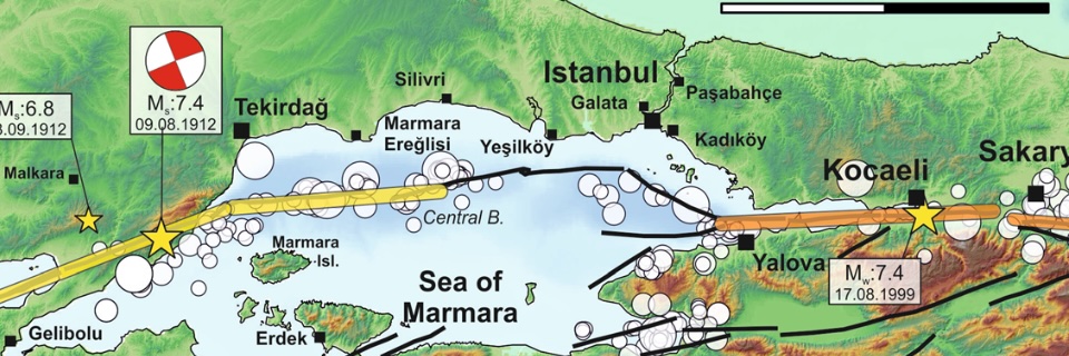
In 1997, Stein, Barka & Dietirich drew attention to an earthquake sequence that had been going on for 60 years. These earthquakes were all along segments of the North Anatolian fault. The list and map is reproduced from their paper below.

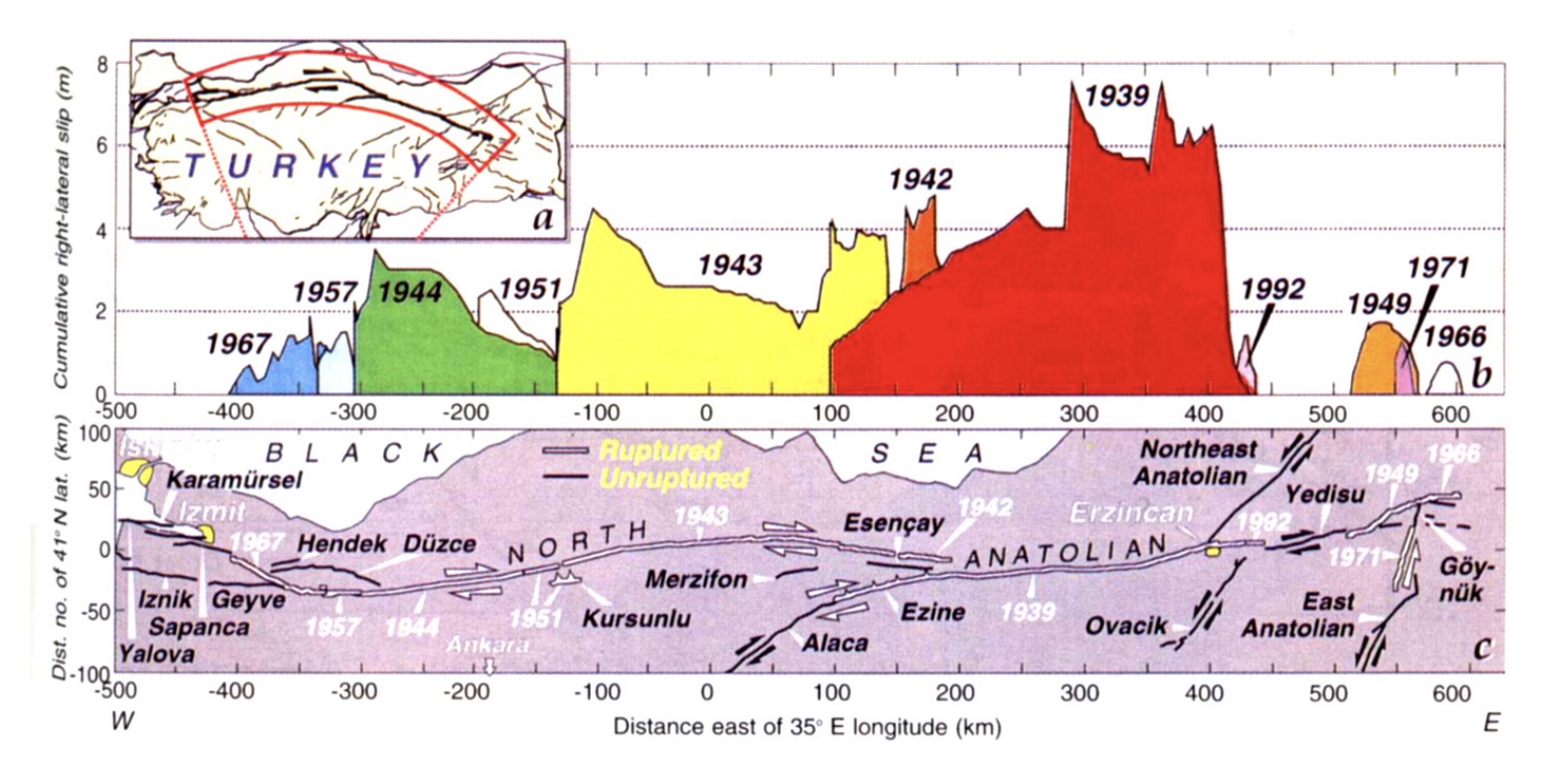
The sequence originated in the east with the very large 1939 earthquake which hit the city of Erzincan. A 350-km long section of the fault broke. This was mid-winter with temperatures well below freezing. Aid took long to arrive. Some 33,000 people died in this devastating event. In 1942, a small section at the western side of the 1932 fault. This turned out to be a prequel: a year later a much larger, 280-km section broke to the west. This was followed in 1944 by the next section, around the town of Gerede. In total, over these 5 years a section of 700 km of the North Anatolian Fault had ruptured.
In 1949 an earthquake occurred much further east. Although on the same fault, this was not related to the previous sequence. In 1951, a small gap in the previous sequence was filled in. The sequence continued a few years later, when in 1957 and 1967 the next two segments to the west ruptured, adding another 100 km to the rupture.
Stein et al. showed that each of the quakes had increased the stress on the next segment, and thus had caused the next earthquake to happen earlier than would otherwise have been the case. In some cases the time acceleration was fairly minor. The 1943 earthquake had been very little advanced by the stress change: it ‘just happened’, unrelated to the precursor. But the 1944 earthquake was brought forward by some 30 years. The 1957 and 1967 events also happened 30 years earlier than would otherwise have been the case.
In 1997, the authors found that the stress had been transferred to two sections: one just to the west of the 1967 quake, and one to the east of the original 1939 earthquake.
Just two years later, the western segment of these two ruptured, in a double earthquake in August and November 1999, which devastated the city of Izmit.
And here the march of the earthquakes ended. The fault further southwest (in the Dardanelles) had a massive double rupture in 1912, and it is not ready to fail again, at least not in a large event.
But there remains a gap. One section is left unruptured, in between the 1912 and 1999 events. And this segment, which may be the last step in the magnitude march, comes to within 20 km of the city of Istanbul.
The Fault and the Marmara Sea
Between the Black Sea and the Aegean Sea lies a much smaller body of water. This is the famous Marmara Sea. It is connected to the Aegean Sea by the Dardanelles Straits and to the Black Sea by the Bosporus. Both are natural waterways. If you are interested, and this is really the only volcanic connection in this post, the name Bosporus originally referred to a cow. The name translates as ‘ox ford’. If you are now in serious doubt how this is volcanic, it comes from Greek mythology. The story begins with Io, a princess who (unwisely) became involved with Zeus. Hera, Zeus’ wife, took exception to this (no surprise there) and turned Io into a white cow (that was more unexpected). She also imprisoned the cow Io, just to make sure. However, Hermes managed to set her free (another story). Hera now resorted to sending a fly to sting Io continuously, in order to keep her moving, presumably away from Zeus. Eventually cow Io forded the Bosporus towards the Caucasus. That crossing is the origin of the name Bosporus. Io eventually regained human form, and later one of her grandsons, Byzas, founded Byzantium – the Greek settlement that became Istanbul. Io, of course, also gave her name to the most volcanic body in the solar system – and that will have to do for the volcanic connection.
(The spelling Bosphorus which is sometimes seen is incorrect.)
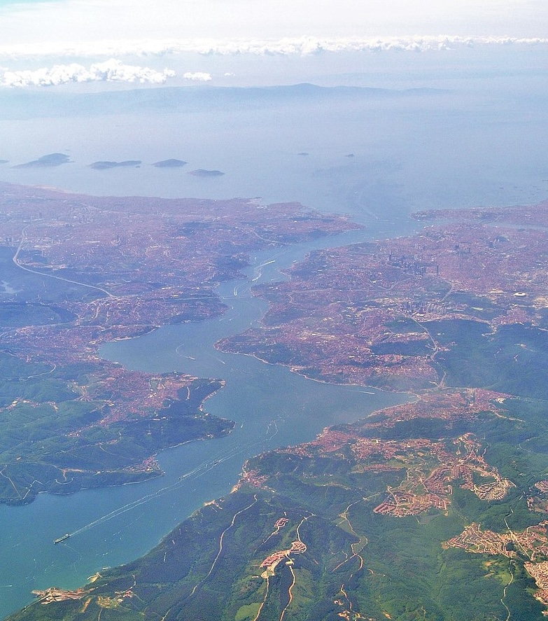
The Bosporus, with the Marmara Sea and the Kizil Islands in the background and the city of Istanbul along the shoreline. Source: Wikipedia
The origin of the name ‘Marmara Sea’ is rather more prosaic, albeit also Greek. It is named for its marble, which was found on islands in the southwest part of the sea. The Marmara Sea is 280 km long and 80 km wide. Although much of the sea is fairly shallow, it also contains a long trough which reaches 1350 meter deep.
The reason that the sea is here lies in the North Anatolian Fault. Here is where the Anatolian plate begins to rotate towards the south. The fault line still runs fairly straight, but Turkey bends away. The Anatolian plate therefore pulls away from the Eurasian plate along this fault line. The Marmara Sea is this pull-away basin, and the trough follows the fault line.
The North Anatolian Fault runs through the narrow Gulf of Izmit at the eastern end of the Marmara Sea, comes close to Istanbul airport, and then runs past the Kizil (or Princess) Islands, staying closer to the northern shore. Only further west does it begin to bend towards the southwest.
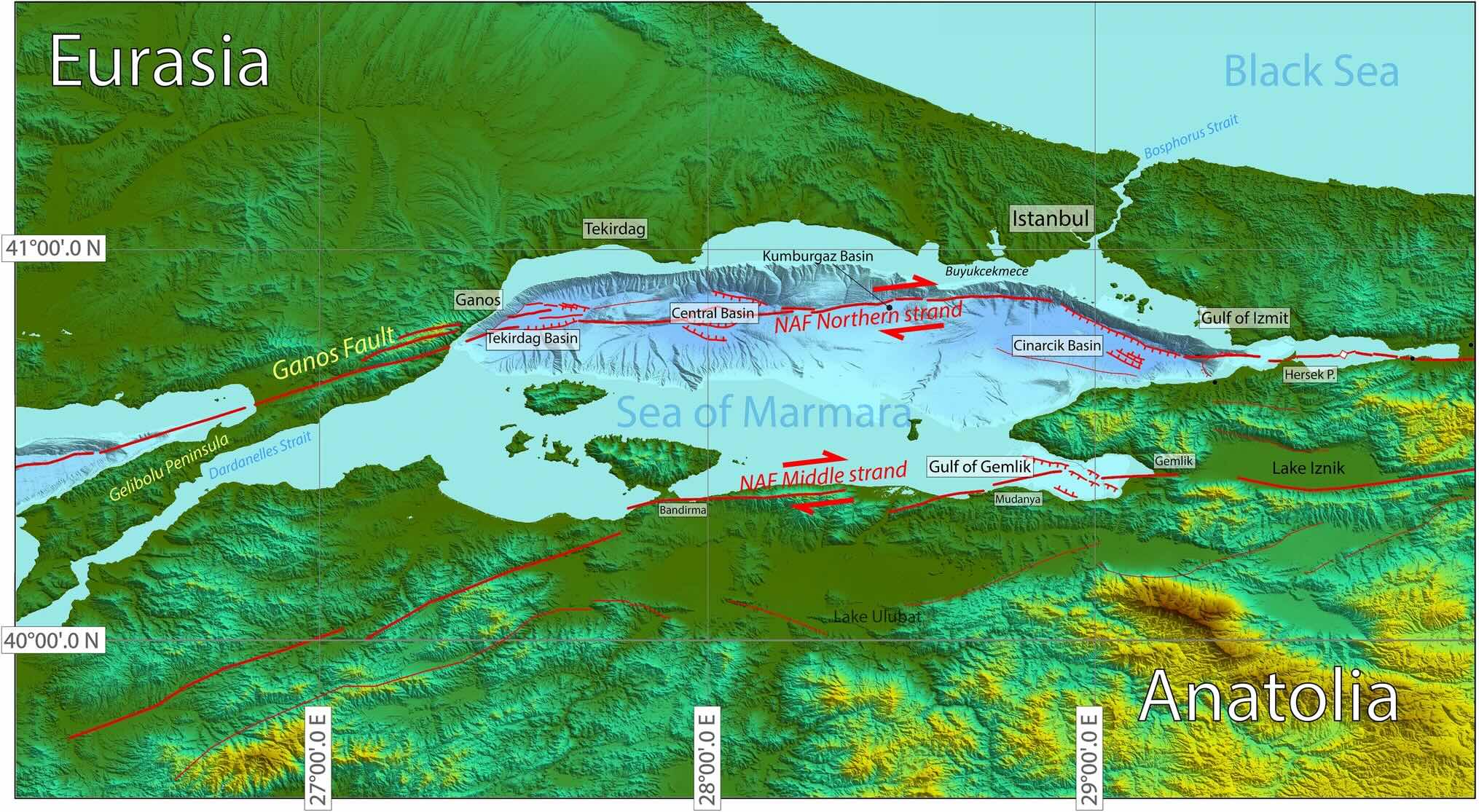
The Marmara Sea has developed three deep basins in its northern half, along the northern strand: from east to west these are the Cinarcik, Central and Tekirdag basins. The basins are around 1.2 km deep, separated by ridges only around 300 meters higher. Between the Cinarcik and Central basins is a larger area which is considered a separate, fourth basin (Kumbargaz basin) but at 900 meter deep it has the same depth as the ridges. The southern part of the Marmara Sea is much shallower.
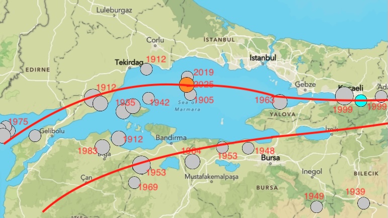
Earthquakes in the Sea of Marmara stronger than M5.5 since 1900. Source: USGS. The fault lines are indicated only roughly and the locations of the earthquakes are approximate.
Faults of the Sea
There are two North Anatolian Faults in this region. As mentioned, the main one runs within the Sea close to the northern shoreline, and accommodates around 20 mm/year of movement. The second one runs along the southern edge of the Marmara Sea, with a movement of around 4mm/year. There is also extension at some 8 mm/yr (the pull-away movement which formed the Marmara Sea) which is accommodated mainly by the second branch.
This a simplified description: In reality the faults are segmented, where the segments are not always aligned and sometimes even run parallel. The main fault is still quite young in this region and hasn’t fully organised itself. The North Anatolian Fault hasn’t made up its mind where it wants to go. Westward-go – but which route? The northern strand is the dominant one at the moment, based on GPS movements.
The northern strand of the fault is called, unsurprisingly, the northern strand. The southern one is called, a bit more surprising, the middle strand. There is indeed a third one that runs further south and is called the southern strand, but it is a wider fault zone rather than a single fault, with many parallel segments running towards the Gulf of Edremit. It is sometimes called the Southern Anatolian Fault.
These faults are responsible for the earthquakes. A map of the stronger earthquakes since 1900 is shown above, with the year of the events. From this, it seems that southern (middle) strand has been more active, but note that it includes a cluster of earthquakes around 1950. The northern strand had the major events of 1912. After that, there were few events until 2019.
In 2019, an earthquake hit the central part of the Marmara Sea. And now, in 2025, there was a second one, not far from the 2019 location. This earthquake caused some damage in Istanbul. And it reignited the fear of a larger earthquake, the missing step of the march. That is not an unreasonable fear. In fact, there was a similar earthquake here in 1905, 7 years before the major rupture of 1912. Was that coincidence, or was there a link? The jury is out.
The fact that the fault is submerged and segmented makes it hard to study. We don’t know exactly which sections failed in which earthquakes, nor how large the failure was. The most recent major failure in the region occurred on the western side of the Marmara Sea. That was in 1912.
The 1912 earthquake
On 9 August 1912, a few hours after midnight, the region between the Gulf of Saros and the Marmara Sea was hit by an earthquake estimated at magnitude 7.3. There had been a number of foreshocks over the preceding two weeks. The segment of the North Anatolian fault that connects the two seas is called the Ganos fault. It continues into the Gulf of Saros as the Saros fault, and on the other side extends into the Tekirdag basin of the Marmara Sea. On land it forms a 45-km long, narrow valley.
This was one of the largest earthquakes known to have hit the Balkan: it was felt as far as Vienna. There are still features and roads in the region that show offsets of 4.5 to 5.5 meters, caused by this event. But these were hard times with war brewing (the Balkan war would break out in October), and the event did not receive much attention at the time. Some 2800 fatalities were reported but there are no accurate accounts. Many towns and villages in the region were destroyed.
The town of Hora after the earthquake. Source: Altinok et al, 2003
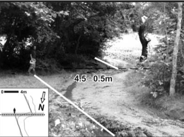
A vineyard road offset by 4.5 meters during the 1912 earthquake Source: Altinok et al, 2003
There was a second earthquake on 12 September 1912, estimated at magnitude 6.8. This is larger than a normal aftershock and it is considered an event in its own right. This quake collapsed some buildings that had been damaged in August. It probably ruptured the segment immediate west of the first earthquake, into the Gulf of Saros.
Together, the two earthquakes ruptured a length of 100 to 150 km. It extended for some 20 km into the Gulf of Saros. As the on-land segment is 45 km, this means the rupture must have extended well into the Marmara Sea. There is evidence for this. Turbide deposit from this event have been found in the sea, and reports from the time report tsunami-like waves which could have been caused by such a submarine landslide.
The rupture likely extended into the Tekirdag basin and possibly the Central basin but no further. The sets the western end of the seismic gap. The eastern end of the gap comes from the Izmit earthquakes which extended some 20 km into the eastern end of the Sea. That leaves an unruptured segment of around 100 to perhaps 150 km.
Source: Aksoy, Mediterranean Geoscience Reviews (2021) 3:95–114 (sorry – paywalled: reading not allowed.)
Recurrence
The offset of 5 meters compared to the movement of 20 mm/yr suggests a recurrence time of 250 years. So when were the previous earthquakes? Is the recurrence time of 250 years common along the North Anatolian fault?
This is not so easy to determine. For historical earthquakes, both the size and precise location may be uncertain. For the region of the Marmara Sea, there were no large quakes (M7+) in the 19th century but there was a significant one in the Gulf of Izmit in 1894. The most recent large event in the area of the 1912 earthquake was in August 1766, at magnitude 7.5 (estimated, of course) along the Ganos fault. This does not fit well with the 5.5 meter slip observed in 1912 which would have needed another century to build up. A plausible explanation is that the larger 1912 earthquake ruptured the segment east of the August 1766 earthquake, and only the smaller 1912 event was on the 1766 rupture. The smaller event was smaller because it had built up less stress since the last slip. The 250 year recurrence time should not be taken with absolute confidence!
The map below shows the main events since 1500. It shows two gaps, on the northern strand in the eastern half of the Marmara Sea which last ruptured in 1766, and on the middle strand below the Gulf of Izmit which last went in 1719.
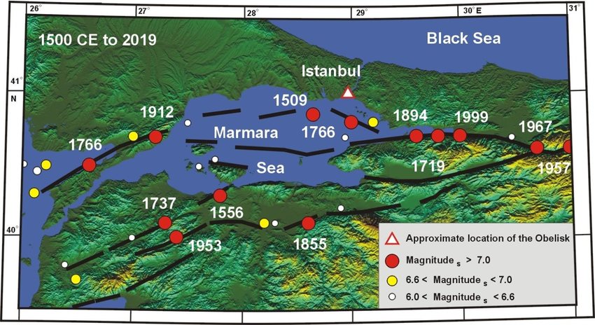
Original source: Ambrasey and Jackson, 2000
The historical record goes back a millennium further, to the founding of Constantinople in the year 330. But the descriptions are sketchy and make it difficult to separate the major from the moderate events, or to decide how far from the city the epicentre was. Here is my selection. Note that the name change to Istanbul occurred in 1453 (but was made official only in 1930).
Istanbul/Constantinople major earthquakes
22 May 1766
The most recent major earthquake which impacted Istanbul directly was in May 1766. It had an estimated magnitude of 7.1. The epicentre was probably around the Cinarcik basin, just south of Istanbul, although this is not certain. There were some 2000 fatalities, of which around 800 were in Istanbul itself.
It was followed by the even stronger destructive earthquake (M7.5) in the Dardanelles in August. That event did little damage in Istanbul.
A common feature of these two earthquakes was that masonry building would collapse but half-timbered buildings would remain standing, albeit with damage. The same had been seen in Lisbon 11 years before. In Lisbon, the rebuilding was done to more stringent building standards. That was not the case in Istanbul where the rebuilding was much less regulated.
1509
On 10 September 1509, some 50 years after the city had been conquered in 1453, it was hit by a devastating earthquake. This became known as the ‘minor judgement day’, referring to the tradition that an earthquake will accompany the last judgement. Some 5000 people died and reports state that not a single building in Istanbul was left undamaged. What remained of the old walls collapsed. The Sultan escaped death when his bedroom collapsed shortly after he had left.
This was worse than the later 1766 event. It was likely an magnitude 7.2+ event, with an epicentre also in the Cinarcik basin.
1343
On 18 Oct 1343, there was major destruction in Constantinople, with damage to the city walls and Hagia Sophia. Turbide deposits found in the Central Basin are dated to this event. They show that the earthquake was large enough to cause large slides in the basin, and this makes it likely it was one of the major events. No turbide deposits have been found in the Cinarcik Basin, but the record there does not go far enough back for this.
989
There was widespread damage in the region and the western dome of the Hagia Sophia collapsed. The earthquake was felt as far away as Italy, but the precise location of the epicentre is not known.
740
On 26 Oct. 740, a large earthquake hit Constantinople. This again was large enough that turbides have been seen in the Central Basin.
14 December 557
This was only 15 years after the disaster of the Justinian plague. There had been two earthquakes that year earlier that year which had done little damage. The third was much worse. It struck just before midnight. Agathias Scholasticus wrote that Constantinople was almost leveled to the ground.
The air was full of dust and people were afraid to enter buildings or churches. As an interesting aside, Agathias writes that a large number of women of all social classes went beyond social decorum and consorted even with men of lower status. The earthquake not only leveled buildings, it leveled social distinctions as well. Some of the city walls were destroyed and the Hagia Sophia was damaged. The state of the city, after having lost a quarter of its population to the plague, was such that few repairs were done. On 7 May 558, an aftershock collapsed the eastern half-dome and part of the main dome of the Hagia Sophia.
This event is also notable in that it coincided with the largest extent that the Eastern Roman Empire reached. After the Justinian plague the wars of expansion had resumed although with greatly limited man power as so many people had died. (That was true for both sides in the battles.) One can speculate whether this earthquake had a role in the contraction of the empire that followed. For more information on this period, see the VC post on the apocalypse.
The city has been affected by many more reported earthquakes. For events which occured before the 19th century, it is difficult to separate the major ones from earthquakes that were moderate or had an epicentre further away. Sometimes an earthquake elsewhere in the empire was reported from Constantinople without specifying the actual location. Here are some events that caused damage in the city but seemed smaller or more distant:
1894 This was a large magnitude 7.3 earthquake which occurred along the Gulf of Izmit. It was far enough from Istanbul that there was little damage in the city but to the east the damage was serious. It probably ruptured the fault that runs along the southern side of the gulf of Izmit, on the ‘middle strand’.
1855 A magnitude-7 quake occurred south of the Marmara Sea in the region of Bursa, on the middle strand. It caused minor damage in Istanbul but was felt widely in the region. The city of Bursa itself was severely damaged.
1841 This event has been assigned a magnitude 6.1, and so is not one of the large shakes. Still, it caused some damage in Istanbul, with the collapse of minarets and parts of the wall. A report states “ many walls were demolished opposite Kazgancilar on the Mercan side of the Serasker Gate. Ten offices were demolished on the inside of the thorough fare of the han at the head of Kalpakcilar. The walls of 12 rooms on the middle floor of the Kebleci han; two rooms on the ground floor were demolished opposite Vezir Han; in the upper part of Yarim Tas Han, the walls of five rooms and the porch and the doors alongside were split; the walls of two rooms on the ground floor and five rooms on the upper floor of the Yaglikci Han in Tavukpazari were split. Some of the walls of five rooms in the Nakbecbi Hani were also split; the walls of three rooms were cracked in the Tas Han wineshop in the area of the Kucuk Tas Han” (Ambraseys 2000, Journal of Earthquake Engineering, Vol. 4, 377 (paywalled).
869 This event is notable because of the collapse of churches. It is known as the ‘great earthquake of the reign of Basil I’. It followed another damaging event in 866
Intervals
The record does not seem to support a regular interval of 250 year of major earthquakes in Istanbul. This time difference exists between the 1509 and 1766 events, but the medieval earthquakes have intervals between 150 and 350 years. In fact, the interval between 1766 and 1894 is even shorter. The segmented nature of the fault may complicate the patterns: a short interval may be because the earthquakes occurred on different, adjacent segments of the fault, and sometimes a neighbouring segment may trigger an early release of the stress, causing a smaller and earlier event. Purely based on historical intervals, the next major event could be as late as the end of this century. Or it could have happened a century ago.
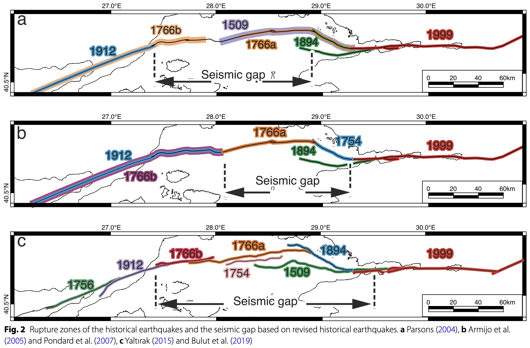
Combining the more recent earthquakes, Sahin et al (2022, Earth, Planets and Space, 74, 167) show three possible maps for which segments belong to which earthquakes. These leads to three different sizes of the unruptured gaps! The middle option (panel b) appears most likely.
The 2025 earthquake
On 23 April 2025, Istanbul was hit by a magnitude 6.2 event. The epicentre was at the eastern end of the Central Basin, probably at the end of the rupture zone of 1912. The epicentre was around 70 km from the city. A few hundred injuries were reported and there was damage to some houses.
The same region was also struck on 26 September 2019 with a magnitude 5.8 event, which also caused some minor damage in Istanbul. This event had been a surprise as it was not centred on the main fault and no fault had been known at the location of the epicentre. Sahin et al (mentioned above) have found indications for buried faults along the ridge that separates the Central and the Kumbargaz basins, called the Silivri Ridge. One of these, called (of course) the Silivri Fault, caused the M5.8 earthquake. They calculated that the event increased the stress on the other faults in the region. It is probably one of those which failed in April. Whether this was another ‘secondary’ fault or the main one is not clear at the moment. The M6.2 size is within range of the secondary faults but the location seems close to the main fault.
The secondary faults are very poorly known. There are many of them, but they have much longer recurrence times than the main fault. So every event there comes as a surprise.
What does this mean for Istanbul? The optimistic view is that the M6.2 event occurred on the main fault and released some of the stress on the seismic gap. The pessimistic view is that it is a foreshock to the main event. The neutral view is that it occurred on a secondary fault and has little impact on the main fault. The optimistic view seems unrealistic. There is enough built-up stress for an M7 to M7.2 earthquake. An M6.2 carries only a few percent of that energy and so has little effect. The pessimistic view is based on the fact that foreshocks are not uncommon for major ruptures along the North Anatolian Fault. It also assumes that the seismic gap in the North Anatolian Fault is ready to go and that the event added stress to it. The neutral view is, well, neutral.
There are knowns and there are unknowns. Istanbul is located near one of the most dangerous faults in the world, and it has been hit badly several times before. The time since the last major earthquake on the segment of the fault close to the city is now over 250 years. The Izmit earthquake in 1999 caused significant damage and fatalities in Istanbul: a large earthquake much closer to the city would be much worse. So far, so bad.
But predicting earthquakes is risky, and predicting their magnitude even more so. We don’t know how large the locked segment is: it may be much shorter than proposed. It may fail not in one event but in two separate ones on either end, which would reduce the impact on Istanbul. We don’t know how fixed the recurrence time is: it may be longer than thought.
There are reasons for concern. The 2019 and 2025 earthquakes may indicate a growing instability. In history, earthquakes here have often come in pairs with one large event followed within decades by one on the next segment. Foreshocks (in hindsight) have also not been uncommon, as per the pessimistic view. The optimistic view would counter that most earthquakes are not foreshocks, and the neutral view would point out that this is best decided in hindsight.
But the major cause for concern is that the experience with past earthquakes has shown that building standards can be viewed as optional. The catastrophic toll of the devastating 2023 Gantziap earthquake, with 57,000 fatalities, suggests not enough was learned from the destruction in Izmit two decades earlier. If the same is true in Istanbul, then the next event may leave little of the city standing. In a metropole of 17 million people, that could be much worse even than the Gantziak earthquake.
The bottom line is that the April 2025 earthquake is a wake-up call. We don’t know when the next earthquake will be nor how large it will be, but we do know it will happen. It is time to check the resilience of the buildings, and test the emergency plan. Istanbul, Los Angeles, Christchurch: beware. The countdown is on.
Albert, May 2025

At the VC office


Etna having a blast!
VD has published a good photo (Boris Behnke) that shows that the eruption was a fast lava flash flood, a bit comparable to the style of 21st Episode of Kilauea:
https://www.volcanodiscovery.com/etna/current-activity.html
Kanlaon today!
https://ibb.co/HTDFZf9b
Talking of faults this is a must see.
Hmm, playback disabled on other websites. No idea why Shawn does that on educational videos.
Dan posted a watchable video of this on the previous post. I am wondering though whether this is more like the ruptures at Grindavik, which followed the lines of buried pipes.
Just click on that “Watch on YouTube” and it works alright. Or append /watch?v=CfKFK4-HNmk to the end of youtube.com URL.
Albert, you say of the Alpine Fault: “The most recent major earthquake occurred around 1717, and the recurrence time is estimated at 300 years”
You’re missing a key word: *average*. Average recurrence time. So many people overlook that.
The shortest interval between major earthquakes there is ~140 years; the longest, ~510 years.
So it would have been no surprise if it had ruptured a hundred years ago. It would equally be no surprise if it still hasn’t ruptured a hundred years from now. Or at 2.30 this afternoon (I say that because I go off duty at 2pm!) All we can say is, it’s in the window.
Do we have enough data to calculate an average? I used ‘estimate’ deliberately as it is implies less accuracy than average. You are right, of course, and people can indeed misinterpret this. I will add the word ‘average’. I make the same point on recurrence times being a flexible term later in the post.
Yes, we have a longer and more detailed paleoseismicity history now, hence us being able to assign those minimum and maximum recurrence intervals. Quite a bit of work has been done in this area. I’ll try to dig up (no pun intended!) a paper.
or average +-2 sd? Maybe 1.0 or 1.5 is better.
In farming many trials deliver less than the (overused) 95% confidence limit.
Often they turn out to be significant years later, when the information is semi-obsolete so one may need to take a value judgement based on real data that has less significance than one might like.
For things with significant variability, I prefer to say something like “significant to 75%” or significant to “.0001%”. For earthquakes perhaps “average of between 90 and 110 years” which is VERY accurate but “average of between 100 and 500 years” gives another picture. Yes, I know this misuses “average” but does, I feel, express available knowledge clearly and succinctly.
You may want to quote ‘mean variation’ rather than standard deviation. It is easier to calculate and often more meaningful. Calculating a standard deviation requires a lot of data and a normal distribution. And quoting ‘between 100 and 500 years’ should specify that this is based on past events. Almost certainly, this will not cover the full possible range. Fukushima was build above the highest recorded tsunami level in the region. It was hit by a tsunami that was quite a lot higher than that. Statistics based on insufficient data can be problematic and is not always helpful.
Yes, I was trying for a description that would be understandable by Mr Average+ (ie who knows what a 30% chance is, so <10% of population) so I avoided technical words. I think my suggestion gives a good flavour and TBH is about as accurate as is sensible!
PS Do you know the paper where a guy did QM statistics on a field of coupled oscillators, these statistics used for 'giant' sea waves? I cannot find it mentioned in searches.
https://www.cambridge.org/core/journals/anziam-journal/article/water-waves-nonlinear-schrodinger-equations-and-their-solutions/D87F5416C657F3B5C35AE96DF9F73DD0
It was the QM paper that set this one off I was after, although this is a good read. I’m not sure how these solutions pertain to a field of coupled oscillators impinged by a wave ~their resonant frequency. Are they more or less similar in form?
It all comes down to similar wave equations. Coupled oscillators don’t necessarily do resonance. They can also do chaos. Add damping or driving and the equations become non-linear. That is where current research on this topic is going.
Yes indeed. That’s entirely the point!
OK, so apart from the obvious changes, no special differences.
I have a “vested” interest in that I see a major problem with how QM is seen is the wave-particle duality. After years I have come to the conclusion that its all waves, but something (probably related to spin) enforces something quantised at a basic level which simplistically makes ‘particles’ waves-in-a-box (see hydrogen atom). There are a few things to explain, like why a screen seems to show point impact (from an electron beam) for example and a field of excited interacting atoms producing an ‘unreasonably’ high local field allowing ionisation/photon emission would explain that quite neatly. The Q (in a basic view) of the emitters is important here as it expresses energy storage.
PS The photoelectric effect is routinely oversimplified, all real photoemitters have a distinct slope from emitting to not emitting.
Anyway enough of this, I am too old to become proficient enough in this to prove anything. It amuses me though.
I haven’t gotten to your article yet Albert, will do so shortly. That whole area is fascinating, especially with the Black Sea refilling like it did in near historical times.
New Zealand’s Geonet has just put up a new activity report for White Island. It is a really weird volcano. A couple of nice photos in it from an overflight they did.
I don’t know what you’d call the mode of this eruption. Not Strombolian. There’s no cone formation at all. Instead there’s this one small vent that is continually emitting gas and some very fine ash. That has been going on steadily for months (I’ve been checking the webcams). How is the ash being entrained into the gas stream so continually without explosions? Small amounts of magma must be being somehow levitated steadily. The thing is like a very badly maintained car emitting endless amounts of particulates out its exhaust pipe.
Some of the ash may be from the large explosion a few years ago. Rising hot air will pull the air in at ground level and this can stir up the loose ash.
I wouldn’t assume all this ash was from fresh magma; much of it is likely to be from ‘frittering’ erosion of the wall rock of the vent.
The webcams will very rarely provide unambiguous evidence of the presence, or absence, of ash; a more robust detection of ash can be found in the VAAs issued by Wellington VAAC.
I was going on the Geonet activity bulletins. The one on 16 Dec suggested the presence of fresh magma as the driver of this period of increased activity. And the emission of minor amounts of ash has been described in the half a dozen or so activity reports since that one. They do regular overflights.
Thanks, Albert, for a fascinating insight into what I’d call the domino effect of earthquakes. The Anatolian Fault and San Andreas do like to do the domino thing.
My comment is about the Alpine Fault in New Zealand, which you mentioned in your intro. On 29 Apr that general fault line had a M6.8 and a M6.2 to the south of New Zealand. So it will be interesting to see if the fault continues to unzip to the north into New Zealand proper. Fortunately there aren’t many people in western New Zealand.
I think you may have your dates mixed up; the M6.8 was on 25th March and I was on duty at the time and I did the first preliminary analysis of the event.
It was some considerable distance from the Alpine Fault lineament (which is transitioning to the Puysegur subduction zone in that area) and the focal mechanism was low-angle reverse (or thrust) faulting, not the predominantly strike-slip faulting you would expect from the Alpine Fault itself.
There was an M5.3 on the 30th April but that was unrelated and much further south.
Thanks for your comment Mike. The links are to the USGS entries, which have UTC time signatures. I recalled seeing them at the time on the USGS earthquake map and went and found the entries. If they’re in error it is something to do with USGS not me! Certainly the M6.8 is off the main fault line, but I thought it worth mentioning as the domino effect can be driven by nearby faults too, as they impart strain to the key transform fault.
I don’t know if you can see the links. I insert them since WordPress allows that, and that way they aren’t too much of a distraction. They may not be visible on other devices? I use an ordinary Win11 laptop, not a phone or pad.
A good sequel to the older parts on Turkey, Albert! Turkey or the former Roman Province of Asia has a complicated geological setting with a lot of faults, orogency, subduction, volcanoes and earthquakes. The Anatolian microplate rotates like Iberia, but in a more continental environment.
I didn’t know that the Marmara Sea is up to 1.2km deep. I previously thought that it’s rather a shallow sea like the Baltic Sea. The basin and faults of Marmara Sea look as if there is some local extension. The rotation of Anatolian microplate must cause somewhere extension.
The earthquakes of Turkey are not as heavy as the most severe Californian or Japanese megathrust quakes, but they appear more frequently. They hit each time densely populated areas with many casualties and property damage, while California sometimes has desert quakes.
California does not have megathrusts, I think: that is further north where there is subduction. Megathrust earthquakes (Japan, Indonesia) can be larger than earthquakes from the kind of faults discussed here. They can break over longer lengths. The North Anatolian and San Andreas are segmented and that (luckily) limits the strength but increases the frequency. Megathrusts tend to hit coastal regions. People like living near the coast for many reasons, so these events can hit major cities. Populations near San Andreas-type faults is more hit and miss: some big cities, some very empty land.
What type of earthquakes are the worst earthquakes of California? F.e. the 1906 San Francisco Earthquake that ruined the whole city. It had a Magnitude of 7.9 and was a big move of the San Andreas Fault and the plate border.
The 1857 San Andreas earthquake was a bit bigger but was away from big cities. It can do low M8 on occasion.
https://www.volcanocafe.org/volcano-at-fault-neenach-and-the-art-of-moving-mountains/
The macro movement by the big quakes is amazing. It resembles the big movement of megathrust quakes, but probably on a more moderate scale. The 1906 earthquake moved the ground by 6m. Imagine to see the neighbourhood moving like a train. You don’t know whether your part is moving or the other side. It’s a relative move, an example of relativity inside Newton’s classical physics.
1857 the movement was according to your article “9.5 meter of offset along the fault in the Carrizo plains”
Compared to this the 2011 megathrust earthquake Tohoku (Magnitude 9) moved the Japan Trench by 50 meters horizontally and 7 meters vertically upwards. But here I guess that the horizontal movement was a convergent movement towards the subduction zone, whereas the transform fault zone does movements along the plate border zone.
Thank you very much for raising this again, the brilliant way you cover this, and for covering positive/neutral/negative views of what could be in store.
Living in Chios, Greece 5months a year EQ’s have become more a part of our life than whilst growing up in Norway. Coming here by car 11 times we’ve driven Turkey quite a few times too. The total size of Istanbul never stops to amaze me. It is absolutely gigantic. And even considering the known risk of large EQ’s it keeps growing. That is true for Izmir too.
You can estimate risks and probabilities from here to the moon and back, but people just live their lives. You can say the same about many densly populated places prone to natural disasters on this planet. From the locals here when discussing this, it goes like “Zoi ine”. That is just how life is. It is like they have a built in ability to mourn quickly whenever bad things happen -> go on. So they don’t apply the same standards regarding safety throughout society that we northern Europeans (at least) do. It is what it is. Following events in Pazzouli/Napoli and Santorini recently people are scared (of course) when the feel a risk closing in, yes, but otherwise? “Zoi ine”.
When eventually some large event close to Istanbul occurs, it will be devastating. It is a given (for modern times); the longer the time from the last event, the more is forgotten. Over time also building codes are less stricktly applied as a factor of time. Due to costs, corruption, mentality aso. This was well documented after the devastating 2023 Gantziap earthquake. The 2020-10-30 7.0 EQ close to Samos did some minor damage here, but is already long forgotten. With at least seven 7.0+ EQ’s in Greece the 20th century another should be due soon. But. Whatever will happen in the region next, and where, is anyone’s guess. Most scenarioes are mapped, the rest is timing.
So in the meantime? Live! Enjoy life. 🙂
The Transform Faults are usually free of volcanoes, but sometimes in the larger environment some exist. F.e. some pre-Holocene volcanoes in western Turkey (east of Izmir) and in California the Clear Lake Volcanic Field https://www.usgs.gov/volcanoes/clear-lake-volcanic-field
Can we compare the small/short Icelandic transform faults with the big ones? SISZ is a transform fault that’s free of volcanoes. Only the beginning and end have volcanoes (Hengill, Hekla). The Reykjanes Fault is also a transform fault https://www.volcanocafe.org/the-ballad-of-ballareldar-the-dike-the-fissure-and-the-fault/ but has many volcanic systems. Are here volcanoes, because it’s a mixed transform/divergent plate boundary?
Reykjanes fault and SISZ are the same fault, Hengill is just a part of the complex of volcanoes on the peninsula and only one to have been a mature central volcano at some point although in the Holocene it is probably extinct and back to standard rifting basalt eruptions. There is also Grimsnes east of Hengill, although that one might be dead or at least deep sleep. There was deep magma movement near Hengill 20 years ago I think, it wouldnt be surprising if it became active again soon. An eruption could be dangerous if it destroys Hellishieiði, like recent lava floods at Sundhnjukur but about an order of magnitude bigger volume potentially.
I think potentially, if Bardarbunga is ready to rift at Veidivotn in the 2070s or so, it could end up inducing a lot of activity at Reykjanes. Vatnaoldur in 877 was after the start of the last Reykjanes cycle so didnt cause it but it seems to have been followed by a lot of voluminous eruptions there pretty quickly so there could be a correlation. Hekla also could be set off too, if it hasnt erupted sooner by itself.
Can we compare the transform faults on Iceland with the famous ones in Turkey and California?
The plate boundary on the Reykjanes Peninsula is a mix of transform faults and extensional faults. The latter produces the eruptive fissures.
M4.4 at Campi Flegrei today. Large enough to do some damage.
They declared national emergency. https://www.ansa.it/english/news/politics/2025/05/13/state-of-emergency-for-campi-flegrei-musumeci_84af2c5e-b595-4293-8d2b-001831ada8ef.html
I know this post is minimally volcanic, but Turkey has some of the most interesting volcanism around.
Hasan Dagi, Nemrut Dagi, the Golcuk caldera etc. etc.
The south/southwest is very leaky
Sorry about that! An Istanbul post seemed timely. It just happens to be in the non-volcanic interlude between Greece and East-Turkey/Armenia. Did you know there are mud volcanoes in the Crimea?
There are pre-Holocene volcanoes close to Izmir. So Western Turkey is not volcano-free, but probably linked to the Greek volcanic arc.
I’ve also thinked about the extensional parts of the faults in Marmara Sea. Can they cause a magmatic activity?
Izmir is not close to the North Anatolian Fault. It is, as you say, close to the Greek Aegean volcanic arc. Izmit is on the fault and is in the post but is a different city
There is volcanism quite close to Cappadocia and Ankara. The pleistocene Agicol caldera is not too far away. Also some limited volcanism on the west coast of Turkey probably related to extension or a continuation of the Aegean subduction arc.
Most of it is south central/eastern with a ‘ mantle dome’ having potentially formed
I think it’s perfectly allowed, even to be encouraged. Volcanoes are geology and that makes no sense without faults. You can’t have faults without earthquakes and faults and volcanoes ate intimately connected for the most part.
Grimsey did a second strong earthquake with many aftershocks https://en.vedur.is/earthquakes-and-volcanism/earthquakes/tjornes-small/
A (female) IMO specialist says that the earthquakes are linked to movements of the fracture zone and were without sign of volcanic earthquakes. https://www.ruv.is/frettir/innlent/2025-05-14-jardskjalfti-um-fimm-ad-staerd-austan-vid-grimsey-443710
One for Héctor re his recent VC article.
Magellan mission reveals possible tectonic activity on Venus (Phys.org, 14 May)
The mechanisms they outline for circulation from the surface to the mantle are fascinating. Plate tectonics are one way of doing it, but it looks like there are several other ways.
Past fun tougths Iceland different latitudes.
At latitude 53 – 56 woud be fun what Iceland woud look like today.. at that latitude 53 – 56, That latitude in atlantic is very humid and rainy indeed. I guess that perhaps Vatnajökull woud not exist in that locale more than being a few small icey domes in Bardarbunga and Orfas summits if Iceland was there today. Grimsvotn caldera lake woud be a huge cold Ireland highlands looking thing with dark waters, rest of Iceland woud likey be rather very green and agicultural expansed woud be more widespread, pre – settlement covered in wast cool rainforests it woud overall be even milder and more habitable than it is today. Reykjavik woud be a mild and green place in that situation with likey temperate broadleaf forests being natural tree covering in an interglacial even if it still woud not be very warm, still summers woud get up to t shirt temperatures much more often in that version of Reykjavik. Ireland perhaps woud likey be analougus in climate conditions and Iceland woud be just as overgrazed. Vik in sourthen Iceland and Reykjavik woud get warm enough to support some subtropical plants at latitude 53 in the mild breezes of the Gulf Stream like some places in Ireland do, the highlands woud become prime sheep grazing lands, Svartsengi eruption flows over sheep farmlands in this scenario.
Latitude 73 – 76 is intresting colder than todays Iceland but perhaps not very much so, woud likley not be that much diffrence than current more than that Vatnajökull woud be much bigger and souch and that natural vegitation woud be a marine type tundra rather than todays birch forests, Hekla woud have a small icecap covering most of it in that scenario, likey almost as settled today just with a colder climate overall, perhaps cool enough to form some small ice domes over hengill, Snaefellsjökull woud be icecapped down to a few 100 s of meters to sealevel, another ice dome covers Westfjords in this scenario almost to sealevel, Torfa also haves a small icesheet in its caldera. Reykjavik and Vik woud get good snow every winter and get a rather forgettable summer that woud be 10 c as high summer unlike todays 18 c as a warm summer day. Husavik and Akureyri gets some brutaly cold winters in this scenario
And If you move Iceland to latitude 83 – 86 N I guess it woud have never even be settled for more than a few Inuitan villagers from greenland, Vatnajökull woud likey cover nearly everything down to Katlas glacier coasts and strectch towards Langjökull as a single solid Icesheet.. ( Laki woud be a mega sized gjalp with an effusive tuya stage ) the icecap may reach way beyond Krafla perhaps towards Husavik at that location, another huge Icecap near westfjords merging with langjökull icecap. Katla woud get the name ”uunnaavik” Iceland itself woud likey have the name ” Nunamik ”competely icecapped with perhaps only the fringe of sourthen coast and coastal reykjanes penninsula being unglaciated, many of todays volcanoes woud be un – named buried under ice, Holuhraun woud be a gjalp like event just bigger with perhaps a short lived effusive tuya stage. Much of Northen Iceland woud be totaly unpopulated and the subglacial topography unknown in detail
Its possible that Vikings from Scandinavia woud get to Iceland first in all these climate scenarios the Nordic seafarers where looking west to colonize new lands areas
If Iceland was around latitude 51, the tree line would be at the altitude of 1000m, where now the glaciers begin. Tiny glaciers would only remain above 2000m like Örafajökull and Bardarbunga. Grimsvötn would predominantly do effusive eruptions instead of explosive ones.
This video shows the lava flows in the caldera after Episode 21 stopped: https://www.youtube.com/watch?v=RIJIQPnzDVI
How different is the rise of a lava shield built by descrete episodes compared to a lava shield built by a continuous eruption? Short episodes limit the length of lava flows. So I imagine that a lava shield built by short episodes like this has a smaller area (km²). If the volume that erupted in episodes 21 was erupted by a continuous low scale eruption over one week, the thin lava flows would probably have been able to flow a longer distance.
With the limited area inside the caldera I dont think there is any difference really. Lava shields look like they are mostly created by episodic activity anyway, often there are long a’a flows and thin pahoehoe on the shield itself, with distant flows being hummocky tube fed pahoehoe, or sometimes early stage a’a if there was high fountaining or a strong opening stage. Trolladyngja near Askja and Bardarbunga is a good example that shows the actual shield. Also at Mauna Ulu and Pu’u O’o it was rare that the primary vent spawned large flows after high fountaining, apart from in 2013 all the major flows at both eruptions were at flank vents, not directly out of the crater. However all of this us destroyed for the summit Kilauea shields, and they arent directly on rift zones, so maybe they behave differently. I think we will get these wuestions answered soon rather than the other way trying to predict it.
Only prediction is overflows before 2030, starting 2028.
I imagine that as long as the episodes stay short, the lava flows are going to remain inside the lava field. It’s a long way from the location of the vents beyond the down-dropped block. Maybe we get a lava shield with a steep step around it.
The strong and short lava fountains put most volumue lava – at the moment – immediately on and around the vents. The webcams show that the vents have grown faster than the broad lava field. It’s possible that once the vents grow above the caldera and build a new peak of Kilauea like the Pu’u O’o cone, but on the summit.
The recent episodes have all sent lava flows to the far end of 2018 caldera despite only lasting a few hours. The lava is so fluid it moves very fast even on flat ground, if there is any real inclination at all it forms narrow channels. If the cents build up above the caldera wall and begin overflowing, lava will flow a long way.
By the time overflows happen I think the eruption will be one of two styles. The first is a continuous slow flow feeding advancing pahoehoe. But the second is the same episodic eruptions as now but much larger and wider separated, maybe only a few times a year, but erupting 3-4 months of supply in days. In both cases a lava lake will probably exist at the vents.
Good article, thank you Albert.
I believe though that the situation in California is more similar to Myanmar with the ocean in the west and then a terrane sliding. But this is not important.
A lot can also be learned about quakes from this piece of yours>
https://www.volcanocafe.org/the-great-alaska-earthquake-of-2021/
Subduction Zone though.
The third trigger is a volcanic province (Managua 1972 i.e.)
There is of course an ocean close to the North Anatolian Fault as well. The difference is that it no longer exists..the old Tethys. There are old sutures there where fragments came together Turkey too is one of this fragments that came across. There is similarity with California. But every geological situation is different
Might interest you:
https://www.dailysabah.com/life/history/marine-fossils-imply-turkey-was-underwater-millions-of-years-ago
HVO volcano watch about the ooze put flows happening far from the vents.
https://www.usgs.gov/observatories/hvo/news/volcano-watch-what-lurks-beneath-learning-lava-ooze-outs
Seems to be confirmation these flows really are lava up to over 5 years old that has stayed liquid under the crater floor. Crystal rich and relatively viscous. Although the stuff erupting at the vents is much more primitive and looks like orange paint flowing out of the vents… 🙂
Nothong about the temperature, but given tbe depth of the lake, low thermal conductivity, and that vents have opened under the lake many times, it probably isnt cooled that much. The ooze outs still flow easily.
Also soon to be new livestream from the south side of the vents, same view as S2 cam. I have been wanting a live view this side since the start 🙂
Today (16th May) the episode 22 becomes possible. Spattering has begun. I previously also noted some flames, maybe caused by detonating hydrogen gas. https://www.youtube.com/watch?v=oG5zz9Sjw3E
Between the last episodes there were four to five cycles of shallow/steep inflation. We’ve had around four now. So episode 22 may begin with lava fountains, when the steep inflation tries to resume:
Its already started, second overflow ongoing right now and its likely to fountain tonight or tomorrow.
The behaviour of the “frozen” lava lake is influenced by the 2018-2020 morphology. The bulk volume of the lava lake is in the big hole, where the 2019 water lake was. The solid “frozen” surface above the liquid lava acts like a teeter-totter on which the lava shield is growing on one side now:
https://www.usgs.gov/media/images/no-significant-changes-kilaueas-summit-water-lake-2
 ?itok=3IYQNbFU
The same view during Episode 21:
What an amazing photo!!
I’d like to know who took it – pretty risky hiking that close to the vent during an eruption look at the tephra and probably Pele’s hair everywhere! Definitely well inside the closed area around that end of the caldera. One wind change and you would be a very unhappy hiker if you weren’t carrying a respirator etc
A transform fault in action. It’s of the recent Burma quake. Not every day that you get to see your entire front yard move three metres to the right.
https://x.com/Brick_Suit/status/1922263200352948623
Sakurajima with major vulcanian (?) eruptions today: https://www.youtube.com/watch?v=hr0jcvdthw0
Imagine working in one of those office buildings and that is the view out your window.
Bit hard to get anything done, I would think.
How active is Io compared to many proven rocky Super Earths? Im soure that really strong tidal forces are simply superior even compared to size unless the rocky object is extremely large. Im reading about exoplanets that have tidal heating as mucy 10 times more than Io s which likey results in a global magma ocean.. thats said 10 Earth masses of rocks and metals sourely gets very hot too!
10 earth mass or bigger terrestrial planets probably only exist close to stars though, otherwise they would turn into gas giants. So they are probably nearly molten from that too. Only exceptions might be ejected planets formed in these environments, or cthonian planets evaporated to their cores. Or an artificial planet.
Technically though, an iron planet has no size limit up to the point of degenerate matter in its core. So an iron planet with a thin mantle could be much more massive than even some stars, while still looking like a terrestrial planet.
On the other end, a water giant that is frozen would have a solid surface. Even though technically suxh a planet would be a ‘gas giant’ in classification, they are very different from Jupiter. Planet 9 if it is real might be such an object, its supposedly in the super earth range, but out there it will be more icy.
Excellent and interesting article, really like the balance of discussing the seismic gap without exaggeration or fatalism. Definitely a lot of interesting events ahead of us, with Nankai Trough, Alpine Fault, San Adreas, North Anatolian Fault all under pressure. Just hope the various countries are prepared. Visited Istanbul before and some of their residential tower buildings look really dangerous.
Looks like episode 22 is starting at Kīlauea. Seems too intense and persistent to be a precursor…
Yes, a growing fountain is springing in the lava pond. It’s now after 5 am HST. If the episode lasts as long as the previous ones, it should last until Hawaiian lunch time.
View from down-dropped block, shows the perspective on the whole scenery. Lava flows will probably run towards this webcam:
Yeah, it looks very tall now. Don’t want to be that guy, but would like for the camera to zoom out to grasp the full scale of this episode…
Well, looks like someone listened to my prayers…
The falling lava drops resemble a Blizzard White Out event. It is like a “Curtain of Fire” by a single vent.
It’s impressive how the eruption can do such a large volume, although it does long breaks. Between the episodes the volcano looks deep dormant. You can’t believe that it erupts more than Pu’u O’o or Mauna Ulu. But when the episode begins, you/we can understand why the output rate is so high.
Imagine, how fast the caldera would fill, if the episodes happened after each other without break. F.e. 24 hours of the rate that episode 21 or 22 do. How close would such an eruption come to Mauna Loa’s rate 1950?
Well, now it looks to be a 1,000 footer right now…
Speaking of Maunaloa, I couldn’t really find any eruptive rates for 1950, but did find this:
https://www.google.com/url?sa=t&source=web&rct=j&opi=89978449&url=https://files.hawaii.gov/dbedt/economic/databook/2020-individual/05/051920.pdf&ved=2ahUKEwiDktObtKiNAxUOHzQIHf7uNT4QFnoECCcQAQ&usg=AOvVaw32lHUZfgGrUYfbVvUv3yvU
Doing a bit of math, I find its average eruption rate to be about 190 m³/s, but it’s initial rates could be higher. Unlike this eruption, however, it is spread over fissures that extends for kilometers, whereas here Kīlauea erupts from one or two large vents…
Do we have anywhere the volumes of Kilauea’s single episodes?
I think someone mentioned the eruption rates (K.O.):
https://www.volcanocafe.org/the-volcanic-dusk-of-venus-part-i/comment-page-2/#comment-164361
https://www.volcanocafe.org/the-volcanic-dusk-of-venus-part-i/comment-page-2/#comment-164374
https://www.volcanocafe.org/the-volcanic-dusk-of-venus-part-i/comment-page-2/#comment-164573
Thank-you, Zach! So the last episode was 3 million m³ or 0.003 km³. Since 1st May we have a recurring time of ~5 days. In March and April that was longer. If May continues this frequency, we get around 6 episodes. With optimistically estimated 3 million m³ per episode, this applies to 18 million m³ or 0.018 km³. That’s still below Mauna Loa’s 1975 one-day-eruption with 0.03 km³.
Impressive is the rate of the single episode. 3 millions per six hours are 12 millions per day. The 2023 summit eruptions had:
9/2023 3 million m³ per day
7/2023 1.3 million m³ per day
1/2023 278,000 m³ per day
Mauna Loas 1950 eruption was way WAY higher eruption rate than that. I once found it to be over 10,000 m3/s for the first 6 hours. At that time it was a continuous 22 km long curtain of fire stretching from Lua Hou near the summit all the way to near the SWRZ bend. So imagine 22 km of fpuntains about 100 meters high. For that first half day it was a Laki sized event, basically. 400 million m3 erupted 70% in under 24 hours, HVO quote… 🙂
After a few days lava stopped flowing to the ocean and it became slow and leaky for a few weeks.
0.25 km3/year supply would be 685,000 m3/day, or 3 million in 4.5 days. Probably more like 500,000 m3/day,which would give 3 million after 6 days. Pretty close to observation.
Mauna Loa has the advantage to do big fissure eruptions, a long Curtain of Fires. Kilauea currently does a punctual eruption. The size of the lava fountain is a bit misleading. It’s still smaller than the accumulated force of a long chain of Mauna Loa’s fountains.
Higher now
On V2 we can clearly see the lava shield now. The slopes there are significantly steeper than on the flat lava field: https://www.youtube.com/watch?v=fiyttmA7YkA
The main lava flow aims towards Northnortheast, where Kilauea Outlook and UWD tiltmeter are.
(V3 Cam, live)
Presuming, as Chad mentioned, this might become a livestream soon.
Yep, just now 🙂
I have a faint memory of a VC post discussing the risk of a tsunamii in the sea of Marmara. What is your opinion on that
That risk may be overstated. See https://www.volcanocafe.org/the-north-anatolian-fault/ where it is argued that the tsunami of 1509 may never have happened or wasn’t as high as claimed.
I think it was Geolurking who brought up the idea and build some arguments for a tsunami risk. I cannot find the post but I am pretty shure it was Geolurking. To me, an interested hobby geologist, i looked convincing!
1999 the earthquake caused a tsunami in Marmara Sea: https://legacy.itic.ioc-unesco.org/legacy.itic.ioc-unesco.org/index807d.html?option=com_content&view=article&id=2132&Itemid=3136
https://www.youtube.com/live/BqmpkUdMtyA?si=J-u91yB6nV_kzykC
New livestream angle, V3 cam. Only just started so no view of the mega fountains earlier but now at least there wont be any ambiguity if both vents are erupting or not 🙂
Apparently, most dinosaurs were probably way bigger than we thought…
https://youtu.be/uKYrRtT-arI?si=qlaMVcym5sajkKkW
Especially sauropods, it seems. First being 100 tons 20 years ago, then finding they had a light skeleton brings it down to 60 tons, and now back to 100 but its all muscle…
Its also great to finally get reconstructions that make their necks looks like a weapon of mass destruction and not a target for an easy kill by something 50x lighter… Sauropods and plesiosaurs both evolved long necks and kept them over 150 million years each, if they were vulnerable that wouldnt have happened. We already imagined their tails as a weapon but the neck was just as heavy and physically thicker…
Male giraffes fight with their necks so you have a point.
Lava has flowed all the way to the east end of Halemaumau, to the remaining part if the downdropped block and near the 2023 cones or whats left of them… Unlike a lot of recent episodes that filled in a big lava pond near the vents and drained under the crust this one is a single narrow channel all the way to the other side.
Its incredible how much this has changed in less than 6 months. And that since this time last year all 3 of Kilaueas active areas have had eruptions, both rift zones but now they are both dead again and it looks like the next Pu’u O’o is forming before our eyes.
Maybe most incredible, this entire eruption will be recorded on a livestream. 🙂
The episode lasted for ten hours. That’s longer than the three previous episodes with 4.5 to 8 hours.
“The observatory estimates the volume of erupted lava is 5 million cubic yards.” https://bigislandnow.com/2025/05/16/update-kilauea-turns-in-bit-of-overtime-before-abruptly-clocking-out-to-end-episode-22/
5 million cubic yards apply to 3.823 million cubic meters. It’s likely more volume than the previous ones. Deflation was a bit stronger than the previous episodes. Some episodes release more lava than they’ve inflated before. Other episodes inflate more than they release. The 22nd episode belongs to the first type.
Trust Americans to use a smaller increment so they can measure a bigger and more impressive looking number of them…
Since the episode ended there has been a signal of short tremor bursts that look like gas pistoning, I cant recall that after other recent episodes. And a lot of it seems to be from the south vent too which is glowing brighter than the north vent now surprisingly.
It’s confusing that they sometimes use metric values and sometimes English/American ones. Why not use some native traditional Hawaiian values?
Between the episodes there is some kind of hydrothermal rythmical activity, it’s kind of a gasiform geysir with a thick steam plume instead of a water fountain. This rythmical activity was also visible during the slow build-up towards episode 22. In the north vent was a lava pond like Miraculix’ magic potion that comes up and down regulary.
Maybe the hydrothermal activity is supported by magmatic hydrogen that burns to water vapor.
I have no idea how the HVO got their µrad numbers. Taken from UWD’s graph, they’re 6.0 µrad gained ahead and 9.0 µrad lost during, while HVO has both one µrad higher; I would figure such a large difference would’ve been noticed. Whatever it may be, with how I calculate, I’m at 2.3 million m³ gained ahead at 6.1 m³/s on average, and 3.5 million m³ lost during at 93.7 m³/s on average; the low figure of the latter primarily because it dragged on for longer.
If I were to add up one µrad to the unrounded total effused number, I also end up at 3.8 million m³ rounded, so in that sense good to know using the result of 5 million m³ divided by 13 µrad to convert µrad to volume remains valid.
We can unify some episodes into families or big waves. This year we’ve had three big cycles or families of episodes:
One in January, one in March and one in May. Each of the three families had a peak moment. Until this peak the episodes inflated more than they deflated. After this peak they erupted more than they had deflated before. We’re currently in a downward phase. Eruptions of this downward phase are above average. There may be one more, until we reach the next deformation minimum point.
The defunding of the NOAA will go down as one of the most pointless, inane, smooth-brained, delusional, and arrogant move that such a rich country has ever made
Will any abandoned research be continued by private enterprise, so that any practical result can be “monetised”? 😒
Are they also going to defund NHC (National Hurricane Center)?
Yes
Rich country,well. Not sure about that.
https://www.usdebtclock.org/
https://bridgemastersinc.com/the-most-at-risk-bridges-in-the-united-states/
etcetera
Rich doesn’t mean you know how to spend that money.
The fact Trump was even re elected at all after how hated he was 4 years ago I dont understand. Apparently Biden being an old man is enough to convince fragile egos that he was a worse president than a slightly less old man who is older than he was in 2021 and who will make everything cost 200% as much but say it like everyone else will pay it…
It’s a nonsense world we live in. Logic has no place here
I mean, maybe the US is particularly bad though… Australia and Canada just voted a big middle finger to their conservative parties, Aus so much they actually have no standing to even run again… The US is screwed though, their apparently most forward thinking individual regarding our future is a primary promoter of the MAGA movement and literally the guy responsible for your original comment… its like David Attenborough being a promotor of deforestation…
The US will survive, but its empire died this year…
Americans haven’t lived the full consequences of war like the rest of the world in the past 150 years, and Americans haven’t faced an existential threat next door like the rest of the world. Unlike other countries, Americans have massive amounts of leeway to be fools and morons thanks to it’s good fortune.
Americans don’t value their luxuries and have 0 perspective on what exists beyond their bubbles. The only thing that you can count on is us trying to defeat the other side by any means no matter how much it’s hurts us.
They didn’t notice that the roots for fascism can be found on every continent. It’s not exclusive to Europe. We saw fascist regimes in South America. The ideological roots for fascism that existed in Germany before Hitler, continued to exist in USA. As long as the democratic system worked, this was harmless. But the recent crises let the hidden evil inside humans grow. Pandemics like Corona often cause a pandemics of paranoid thinking (Conspiracy Theories). This was maybe the last factor for Trump II.
Concerning a WW though, Tallis, Democrats under Biden were a bigger risk, and Harris seemed not very much up to the task. That is why he got enough votes.
The victory of Trump was supported by the social media and propaganda financed by the Big Tech Billionaires who seek this type of government. There were Algorithms which favor right-wing content and conspiracy theories.
Trump’s war on science mirrors the long classical conflict between the “educated bourgoisie” and “capitalist bourgoisie”. Both are classes of successfull people above the classical labor class. Both are somewhat liberal classes. The educated class (scientists, teachers, …) usually favors a left-leaning liberalism (free humans), while the capitalist class favors a conservative liberalism (free business …). Science often produces knowledge that contradicts the search of capitalist bourgoise for profit. Labor rights and ecological valuese cost something. If we look f.e. at Elon Musk’s companies, he tries to avoid both. He hires people who work hard and don’t ask critical questions or demand anything.
This is too simplistic. There are a lot of reasons why people are unhappy. Life is fine for the well-off, but everyone else has significant problems: unable to a afford a house, insecure jobs and of course with the high levels of debt after the financial crisis and more recent problems, a lack of trust in a government safety net. Add aging populations which means younger people have to support more and more elderly, either directly or through taxes, add global warming which is disproportionally affecting less wealthy nations, and add rapid changes to technology which means many jobs have an uncertain future. In such cases, desperate people will vote for things which are not in their best interest. It helps to try to understand where people are at. A young man in a poor, insecure job and little prospect, who is constantly being told that men are bad – what do you expect them to do? When did the ‘liberal message’ become so negative? Is it perhaps because they too feel insecure?
Thats one reason why Scandinavia have been so sucessful compared to USA our welfare capitalism, its capitalism but with a resposible framework, in Scandinavia its not everyone for himself. I think USA will really never work as a society as long they runns darwinian “absoute total capitalism” for us in Scandinavians that live ina welfare capitalist state its unthinkable with having no acess to education or hospital servivesas a free public right or having no social sequrity systems for disabled persons. Its really mindblowing that a rich country like USA really cannot pour their immense resources and taxes towards getting better public standards… and public welfare.
They pay their taxes… but alot of the the tax renevue in USA seems to go into rich guys pockets like Musk and Bezos … instead of going to the common good….
The recent inflation was mainly caused by nationalist trade politics. Both Trump I and Biden had it. The inflation during Biden’s administration was caused by similar approach to the global economy. Trump did tariffs, Biden did subsidies. Added to this the war in Ukraine disrupted supply chains and made everything more expensive. The rising costs make everyone poorer. And this path to overall poverty is like a hangover headache.
Usually if the market(s) are left to its/their own, the poverty after inflation is the mean that reduces inflation finally. This lets prices fall a bit, and then you get the balance by the invisible hand of Adam Smith’s theory.
The inflation and cost of living spike was worldwide. There were local issues, such as the price of natural gas in Europe following the outbreak of war and cost of food, but the trend was global. The subsidies in the US were smaller than the tax cuts that already existed. The injection of money into the economy was mainly through loans and quantitive easing, at low to zero interest. After covid, there was a lot of unearned money around. But inflation tends to follow high borrowing by governments, as it is the main way to get the borrowings down as fraction of GDP.
“A young man in a poor, insecure job and little prospect, who is constantly being told that men are bad – what do you expect them to do? When did the ‘liberal message’ become so negative?”
Exactly.
Tsunami. Seems there’s also the possibility in the Tjörnes Fracture Zone.
Gylfi speaks of it here in his channel.
https://youtu.be/XT-mPHb8F5g?t=337
Azores–Gibraltar transform fault, 1.600 km,
1755 Lisbon, 1761 Lisbon, 1816 North Atlantic, 1941 Gloria Fault earthquake, 1969 Horseshoe and 1975,
Lisbon 1755: 30.000 – 40.000 of 200.000 dead, many killed by the tsunami 40 minutes later. Interesting the space of six years twice, 1755/1761 and 1969/1975
The beast. 26.000 years ago.
The beauty today.
Have a nice Sunday everybody!
South Island, Blackhead, Pacific Coast, ~ 10 Ma
wikipedia/commons/thumb/7/77/Columnar_basalt%2C_Blackhead%2C_New_Zealand.jpg/960px-Columnar_basalt%2C_Blackhead%2C_New_Zealand.jpg
You could think the British settlers took some with them. Fingals, UK
Page would not load, so

https://en.wikipedia.org/wiki/Dunedin_volcanic_group
That looks very much like a Minecraft biome…
Thoughts?
Where is it? It looks like the gas pistoning cycle of Kilauea now and leading up to a fountain. But if its at your favorite volcano that doesnt make any sense unless there is a hot spring or similar on it.
It’s my one true love, Cerro Negro De Mayasquer. The stations isn’t located near the hot springs. The volcano saw an explosion of VLP earthquakes last year, which has sustained itself till the present. Episodes of tremor and LPs have also gone up substantially in the last 3 months
The current swarm has been weak all things considered but still VERY interesting to say the least
Its probably because the magma is viscous, and both of the two volcanoes in the complex are lava cones, its probably magma moving up slowly. It will probably be effusive and make a new mountain, maybe over decades like at Santiaguito or even centuries like at Bagana. The opening stage could be explosive though, probably not a VEI 6 or anything but a 4 is plausible. I think if it was a volatile rich magma it would have erupted before now, though.
Its hard to really say anything. Its been a decade at least and still nothing easy to see. But its pretty clear the volcano is waking up and active, just not when it will actually put lava on the surface. Fluid lava moves fast but viscous lava that is in thick compressed crust might be expected to move slowly and take a very long time to erupt.
Both the SGC and IGEPN have mentioned a possible plug somewhere between 2 and 4 km below the Summit, and VLPs have been concentrated at that depth. The Seismic activity in the last 2 years has been similar to Svartsengi and Campi Flegrei.
Could you explain to me what you mean by KIlauea’s “Gas Pistoning cycle” to me? As you might expect for me, I haven’t give your love any attention recently.
If you have watched the livestreams, before properly fountaining the lava level will rise up and overflow, then spatter and sink down. If the vent was smaller or the magma a little more viscous it would be strombolian explosive activity.
Its also very similar to the fountaining at Fagradalsfjall in 2021, although much less spectacular, but the same process.
That’s a swarm of long-period earthquakes (the repetitive signal). Maybe it’s gas periodically shooting into cracks above or near the conduit, potentially opening a path for magma, but it’s pretty common for volcanoes to have these swarms, may not necessarily be a sign of anything…
There are some high frequency earthquakes, from rock moving past each other in there too (few), and probably some tremor episodes.
Depending on the depth of these earthquakes, this could be bad. Unironically if these quakes are shallow than that it would be less interesting.
Lewotobi had a major blast today, alert level raised to 4, because there is risk of its E-Ne side producing collapses.
Evacuations up to 7km away.
The Husband or the wife?
I guess the husband (Lewotobi Lakilaki) as it erupts much more frequently.
https://www.volcanocafe.org/flores-and-the-lewotobi-eruption/
Fascinating:
“Flores lies at the heart of Wallacea, the region east of the Wallace line where the Eurasian ecology ends and an older one remains with echoes from Gondwana. The islands of Wallacea are those which were neither associated with continental Sundaland on one hand or New Guinea/Australia on the other.” Albert, first passage, main piece
I love how the Indonesians apply husband and wife to adjacent volcanoes.
They may be on to something in terms of shared magma chambers.
Do you expect that Svartsengi does any eruption this year or that the first series is over? Inflation is slowly calming down to nearly zero growth on the stations all around.
Maybe the continuous supply of magma started in October 2023 has stopped, but its too early to say it is over entirely. Maybe magma is accumulating deep under Fagradalsfjall again and will erupt over there, and could come back to Svartsengi again later too.
Arnarseturshraun and Eldvorp arent on the same fissure line, and apparently not particularly close in age either, years apart at least. So at least in the last cycle there were two rounds of eruption. Krysuvik also apparently erupted in around 900 and again in about 1150, and 1188. So I think maybe the idea each site erupts/rifts sequentially and only once per cycle is too neat and simple. Theres 200 more years to go, we arent even 5 years in yet 🙂
If uplift is slowing though it means magma is accumulating somewhere else, so we dint need to wait a long time to get an idea. If not back at Fagradalsfjall then over at Reykjaneskagi and Eldey, or at Krysuvik, they are areas to watch now. But really the entire Reykjanes fault from Þingvellir to past Eldey might be all active now and interconnected to some degree, all options are possible.
Is it accidental that Fagradalsfjall all in all lasted for two years, and that Svartsengi probably also lasts for two years (if we count until end of 2025)? Maybe this is the time the systems currently need to get exhausted for a while.
During the Medieval Period the Fires usually lasted around 30 years. So it’s possible that both systems continue to erupt after a pause of some years.
That actually could be a coincidence. Also the dates from GVP are quite different to the neat progressive model. So I think we seriously need to consider any comparison to the last cycle. Its already diverged by starting where it did according to the models anyway.
The Fagradalsfjall eruptions looked as if there had begun a continuous magma supply down there that forces an eruption regularly somewhere. I’d assume that this magma supply continues, but it’s difficult to see and predict, where it’s going to next.
10th century soon after the first eruptions, there followed Surtseyan eruptions of Reykjanes or Eldey. Eldey last erupted 1926, so it is a relatively open system.
Doesnt look like its slowing down anyway, about 3/4 recovered from the last eruption, so due to erupt in June at some point. And last time was the biggest magma run of the whole thing apart from the initial rifting so to be recovered in less than 3 months is above average really.
V3 shows occasionally flames in the southern Crater. Thick gas & steam plumes make it difficult to have a good look into the southern crater. Therefore it’s uncertain whether there is an active lava pond or not. https://www.youtube.com/watch?v=BqmpkUdMtyA
The short intervals mean magma cant drain back much, so its still shallow. I guess for whatever reason the north vent is slightly more open so fountaining happens there first and stays. But tge south vent is definitely open still, it will erupt at some point again.
The recovery is very fast too, E23 will be in only 1-2 days, the fire and intense glow backs that up as a visual sign of high magma level, probably lava really it would be visible from above.
https://www.psychologytoday.com/us/blog/world-wide-mind/201211/do-super-earths-have-too-much-gravity-for-us
Looks like many Super Earths will have a near earthly gravity woud starship be able to takeoff from these at max thrust?
Elon says it’s pretty close for even Earth. If we had much more gravity it’d be impossible. On the other hand with more gravity you could have more atmosphere, and launching from altitude could perhaps overcome the gravity issue.
That’s with chemical propellants of course. The Russians are working on nuclear powered rockets, with a story on that today.
Correct. On Jesper’s super earth, even if the surface gravity is the same, the rocket needs to provide twice the total energy. The thrust of starship is fine but the rocket will need to be much bigger.
Instead, you would launch into orbit and assemble your starship (really a planetship) there. It is much easier to launch from orbit as thrust is not a concern.
For these Super Earths 30 to 40% stronger gravity than Earth woud starship be able to lift? walking on the surface woud be comfortable
A moderatly large Super Earth woud be paradise for me to live in .. it would generate more internal heat a larger earth would be more geologically active. If earth was larger we would have more internal heating..More heat from compression as the planet formed, and more radioactive elements trapped deeper. and a larger planet retains its internal heat more. It would have stronger mantle convection and more and smaller plates and a thiner litopshere under more stress with hot astenopshere being closer to the surface. Very geologically active with numerous ocean ridges and hyperactive spreading centers and subduction zones the larger and more massive a rocky planet is the higher gear the geologically activity -many plates, rifts, ranges and volcanoes; possibly so hot inside that its plates are more elastic than Earth’s.
Super Earth exoplanets maybe displays hyperactive tectonics and a faster mineral cycle
The continents are small and no or very small cratons because the high level of geologically activity. The result is an island world with no stable landmasses and only small protocontinents.
Komatites maybe common on Super Earths with hotter mantles and hotter mantle plumes than ours… their komatitic lifespann is longer than ours… slower cooling
But Io will do fine for me…I hopes for an Io probe soon maybe Musk coud build one…
It’s not his idée fixe. But Chinese were planning to send a probe to Callisto. Maybe they could radiation harden a variant of that, and try Io as well?
How fluid is the lava thats erupting from EPR? the submarine sheet flood type flows and lava whorls certainly looks very fluid looking at the recent footage of live underwater flows showed small pillow flows ( nearly white hot ) coud it be close to 1300 c ? many hotspots like Hawaii and Iceland are of course much hotter mantles but they are either on thicker litopsheres or thicker crusts than the EPR is which tends to lower their eruption temperatures to avarge unless there is a rare direct mantle eruption. Im pretty soure EPR are on avarge one of the hotter erupting lavas even if Hawaii and Iceland can certainly be very toasty too maybe halemaumau is going for heat record in comming years
https://www.youtube.com/watch?v=RFYPKmFNSio
Iceland 2021 was ultra fluid… and halemaumau is starting to look like this as well now
It was more primitive. Did it evolve enough from 2021 to 2023 to erupt as classical basalt 2023-25 in Svartsengi’s system?
The stuff erupted since June last year was the same magma as the 2021 eruption, slightly evolved sitting in the sill. The magma of the 2022-March 2024 eruptions was different, I cant remember exactly how but it wasnt just evolved it had a different origin.
In both cases though the only significant difference was the Sundhnjukur lava has lower MgO because of olivine settling out, and maybe isnt quite as hot although I dont think that is true of the more recent eruptions, those formed shiny pahoehoe too.
Is primitive magma more gasrich? Maybe this was a reason for the Hawaiian-Strombolian Lava-Geysir 2021, and this could be a reason why the present Kilauea eruption is not continuous. Have they checked the chemistry of the current eruption there?
Iceland’s magma has certainly got many options, and some of them are near Reykjavík.
https://www.ruv.is/english/2025-05-16-capital-region-municipalities-prepare-for-volcanic-activity-443979?f
That’s a tourist article. The natives rather care for the ESC result and price of coffee at the moment.
But good news for the Grindavik inhabitants: https://www.ruv.is/frettir/innlent/2025-05-19-grindvikingar-geta-gist-i-husum-sinum-i-sumar-444225
“Innbyggerne i Grindvík kan bo i husene sine i sommer” – They can live in their homes in summer. For them it’s good that the volcano has calmed down a bit.
Tourist article. Mmm. OK…….
I reckon the residents are fortunate to have proactive sensible (mostly) politicians.
Unlike some.
I noticed a lot of the tilt signals at Kilauea are opposite at SDH and UWD. They both trend up but when inflation is slow at SDH it is fast at UWD, probably showing magma flow from the main magma chamber to the one at Halemaumau that directly connects to the vents. There is continuous flow but not constant unchanging flow it appears.
The rate of recovery also might be faster now too, going on 7 microradians in about 3 days, which is a daily supply of at least 750,000 m3/day on the low end… Thats 0.27 km3/year or more if sustained.
HVO did a study decades ago tbat supply rate is low and pressure is high between eruptions, and the reverse during sustained eruptions. But the supply was already high before an open vent appeared last year… So having an open vent could be allowing even higher supply rates and it could be still increasing, especially if there is now a vast deep magma body connected to Kilauea that wasnt there before…
Episodes occur in groups. If draw a line along the minimum points of deformation of all episodes, we get a wavelike curve since January until now. There were three wave crests in January, March and May. Now the episodes are heading for next wave trough. This phase has above-average episodes with strong deflation.
One thing I noticed now, the green line on SDH is trending upwards. This is showing tilt that is approximately radial to the start of the SWRZ and where the south caldera reservoir is. So this magma body is inflating, while the one within the caldera under Halemaumau, recorded by the blue line and UWD, seems to be slightly deflating. There is no uplift on the SWRZ but at some point there will probably be a longer or more intense episode again that equalizes pressure.
Episode 23 will probably begin within 24 hours, if it doesnt then it could be the exact big episode I just said.
It has already begun to build-up towards Episode 23 with H2-flames and spattering: https://www.youtube.com/watch?v=oG5zz9Sjw3E
I’d expect that episode is going to be a bit larger than the average of the episodes. Episode 23 will probably begin, when the currently flat deformation tries to change to positive deformation again. This is supposed to be around 6-9 HST. We’ve had five cycles of deformation between episode 22 and 23.
B1 webcam shows that episode 22 caused a progress of the lava field towards the east: https://www.usgs.gov/volcanoes/kilauea/b1cam-kilauea-caldera-down-dropped-block-and-halemaumau
HVO stopped to count the episodes after episode 21. Do they have a shortage of staff?
HVO mebtioning precursory spattering and flames at both vents this time, so E23 might not be a solo act. That also probably means either it or E24 will be a bigger episode
My prediction was too quick/unpatient… 😉
Some old friends has a very disturbing dreams…
https://twitter.com/el_guayota/status/1924784506453606518
https://twitter.com/el_guayota/status/1924768290984894472
A mini-swarm near Grindavik to celebrate the loosening of restrictions
Krafla has recently also shown some lifesigns. The first time that I’ve seen it recently. It was for long time calm without earthquakes.
Fun question: if Jupiter was twice its mass we woud then have never gotten an atmospheric probe mission in 1995 due to the entry speeds being far too high? Jupiter as it is today… is already an extreme entry it is only possible to do it at the equator along with planets spin to shave off some speed
Woud be fun to try Starship aerobraking capabilities at Jupiter it woud not stand a single chance of course, an object the size of starship falling in will create a visible flash at Jupiter in space telescopes
The Magellan probe successfully used aerobraking to circularize its orbit around Venus. And that was without ablative protection. Neat bit of work. Took a while though: 75 days…
I have wondered if asteroids or comets hitting the Sun would be bright because of exposing the deeper layers, or because of re-entry. The atmosphere of the Sun is still an atmosphere, so should have the same reaction. And the Sun has 22 G surface gravity… 🙂
I wonder if that is a possible cause of super flares that have been seen at other stars and probably the same as the Miyake C14 spike events here. Superflares are the same as normal flares but an impacting comet would probably have electric and magnetic events. They also often fragment so could be why superflares are often multiple close events. Or at least, the massive sunspot responsible could be a ‘impact crater’ of sorts
I think comets actually have hit the sun historically though so that might kill this theory. And strong storms are probably a lot more common than we think because we only saw the ones that hit us until pretty recently, the Earth only covers a speck of the area of a 1 AU radius sphere so even if a superflare covered half of that they might be twice as common as we think. Every 1000 years not 2000, or maybe there was one 200 years ago but pointed the other way.
I think 600 km a second is the entry speed in the lower cromosphere far far exceeding Jupiters entry speed of course, you heat shield may likey face shock front temperatures of a few
100 000 s of degrees c!. Already at jupiter you already gets 15500 – maybe up to 16 000 c at minimum entry speed and low angle making jovian entry along its equator on the edge whats barely possible with areoshell heat sheild technology today.
And on small Red Dwarfs and large Brown Dwarfs those haves much higher surface gravity than our Sun makes even way much much higher entry speeds….
I imagine the surface of a red dwarf is so dense it is basically a liquid, so an impact might behave like hiting a physical surface and so be much more of an instant event. In real life though even a small red dwarf would look blue white to our eyes up close though, up close, so you probably couldnt see it still. It would be like looking at burning magnesium, probably still a lot of UV and visible even though they radiate brightest in the infrared.
The sun probably has a higher surface gravity still though, its much less dense but also tens of times the mass. At stellar orbital velocity anything that isnt a hard vacuum probably might as well be a solid object…
So a Red Dwarf will not even have a warm tone to its white light? I read that the smallest ones haves a white yet – liquid ironish glow to them. Earth placed under one in life zone sounds like a very pleasant day without sunglasses or UV cream or sharp shadows.. everything will be warm and gentle and afternoonish at lunchtime
I wants an atmospheric probe for the Great Red Spot packed with all
kinds of instruments and miniatyre system cameras, it will be fun it will be hit by ammonia hailstones and deeper storms of odinary water thats a part of Jupiters bottomless water – volatiles clouds cycle.. who knows coud be a cloudscape that looks just like Bespin in star wars. Im curious how dense the jovian cloudscape are, if many of the clouds have very sharp edges like Earths some Jovian water cumulonimbus may suggest so even if Junos resolution is quite poor .. Im soure Jupiter have beautyful skies with cumulonimbus anvils pushing into fields of cirrocumulus
A question for Albert regarding apart of this article.
https://www.volcanocafe.org/the-ljosufjoll-earthquake-swarm/
“The SVZ contains four distinct volcanic systems. From west to east, these are Snaefelljökull, covering about 600 km², Lysuskard (150 km²), Ljósufjöll (1,800 km²) and finally Snjofjöll. Snaefelljökull may have had as many 30 eruptions in the holocene, Lysuskard (around the mountain range labelled Snaefellness on the map) had two and Ljósufjöll some 20. Snjofjöll has not erupted in that time and may be extinct: it is normally left off the list. ”
Snjofjoll seems to be a cap of ancient (for Iceland) lava, between 0.8 and 3 million years old, so probably well over 1 million. Theres no craters on it either, so its not clear if the mountain is a mesa left by erosion and the lava was erupted at Langjokull or in that area at least. It doesnt look like a parallel fissure swarm with Ljosufjoll as if it was a 4th system. There is also only a single reference to it being a volcano itself, from another volcano blog that applies a totally unscientific reasoning behind it so Im wondering where the source is? That part of Iceland gets forgotten about and is as geologically active as the rest of Scandinavia today, so would be interesting if there is more to it.
There is a Snjofell, and it is better known being an accessible location close to Snaefellsjokull. Maybe a confusion of the two. My autocorrect also changes Snjofjoll to Blafjoll, which is near Reykjavik and definitely active. That might be part of it too.
It is listed in https://nat.is/snaefellsnes-volcanoes/ as a separate system. The eruption sequence is described in Hauke Johannesson’s thesis, https://core.ac.uk/download/pdf/16669719.pdf The point is that this Snaefellsness is part of a line which was much more active on the past and stretched all the way to Hofsjokul. Since the onset of the ice ages, the activity has focussed on the peninsula. Reykjanes has taken over in activity and publicity but there is still residual activity here – though not in Snjofjoll.
Ages of 1-1.5 million years, and eroded down. So extinct. Volcanism might resume here again but not soon. Its actually pretty surprising how many systems in Iceland in currently quiet places were active so recently. Reykjanes is still strong, being the plate boundary, but I think Þingvellur has only a weak claim to being a true boundary now. The so called Hreppar plate seems to be an artificial concept trying to link Langjokull to Bardarbunga through Hofsjokull, but theres nothing supporting this being an actual crack.
The part of Iceland that has probably grown the most in the Holocene is the south end, especially Hekla and Bardarbunga. Those two, as well as Reykjanes, are the most active areas in the last few millennia in number of eruptions plus average eruption size. No surprise these 3 are also the plate boundary too…
Is the relation between the old and the new peninsula a reason, why during Reykjanes Fires there occured eruptions on Snaefellsness Volcanic Belt? Maybe the systems correlate positive some way. There is perhaps an elevated probability that Ljosfufjöll or other volcanoes on SVZ erupt during RVZ Fires … but no certainty that it acutally happens each time.
One possibility is pure chance. The Reykjanes fires go one for about a quarter of the time (300 out of 1100 years), so any Snaefellsness eruption has a 25% chance of occurring during a Reykjanes fire season. That is pretty good odds. But it is also possible there is a trigger. The reykjanese eruptions come from short dikes, 5 km deep and 10 km long running mainly north/northeast. There are also much deeper dikes, at 20 km, running in the same direction. These never reach the surface. If they can reach Snaefellsness, than that could inject heat into their old magma reservoirs. Speculation.
As far as I know both the Medieval Fires and the Roman Period Fires were accompanied by a few eruptions on the SVZ. Otherwise the SVZ was calm during last 2000 years. This looks to me as more than random events.
Are the Reykjanes Fires only driven by extension/rifting or also by pulsating of the hotspot? If the western wing of the hotspot has times of high activity and times of low activity, both RVZ and SVZ may together share the moments of high activity (although on SVZ on small scale).
Went back to read some comments I missed:
Albert
16/05/2025 at 19:50
That risk (of tsunami) may be overstated. See https://www.volcanocafe.org/the-north-anatolian-fault/ where it is argued that the tsunami of 1509 may never have happened or wasn’t as high as claimed.
The highest risk in the Mediterranean Sea is probablyin and near the Strait of Messina
But tsunami risk are also overstted when numbers are compared: 75.000 died in the collapse of Messina from the earthquake, only 2.000 from the 12 m high wave. One could argue though yhat the number is relatively low as most inhabitants had already died.
https://en.wikipedia.org/wiki/1908_Messina_earthquake
Lisbon Earthquake was the Atlantic Coast.
Rare survivor:
Chiesa dei Catalani, Messina
Amazing
So Siciliy is ~80% Africa, while the Strait of Messina is Europe. Etna sits between the plates. Difficult to differ between the continental plates there. The Adriatic micro plate is part of the African “mother plate”. The Alpes are the border between Greater Africa and Europe. Italy has a dual continental citizenship …
Not really
The Adria Plate is a loose part of the African plate. It divorced from Africa, but is related to it.
Considering that Italy is not really Sicily and has a different story altogether. Sicily belonged to the Bourbons until the middle of the 19th century (before to other kingdoms and entities) and originally wanted to become an independant state.
Africa is sinking back into the mantle there, subducting. So, Africa is shrinking and splitting up. The other shrinking “continent” – sort of – is the Pacific Ocean whereas Eurasia and the Americas grow.
They have something in common, those two: Large low shear velocity provinces (LLSVPs) named after John Tuzo Wlison. Whether they have s.th. to do with this coincidence is unknown to me.
Albert might have an idea.
The second area which is very much at risk is the Aegean Sea South around the islands, Southern Greece and Southwestern Turkey, and the recent swarms made everybody nervous.
A tsunami has to come from somewhere. So, it is either caused by a landslide (Messina/Storegga) by an earthquake in a subduction zone (Sumatra). The water is sucked into the trench, and it is a lot of water. Then it is spat out again with force. As there is no subduction zone in the Marmara Sea a bigger earthquake is rather improbable. A smaller earthquake caused by a landslide cannot be excluded. As there is no volcanism up there however, a flank collapse like Etna could produce and is disussed around submarine Kolumbo Volcano near Santorini would not happen near the Marmara Sea.
https://www.lyellcollection.org/doi/full/10.1144/SP291.1
So, I would say that the area between 36,4 northern latitude (Santorini) and 38.2 (Messina) is most at risk by an earthquake and following tsunami.
Lisbon I excluded as different dynamics in different ocean.
small but important corr.: or by an earthquake
https://www.youtube.com/watch?v=ahLp5-BxISA
Grimsvotn looks like Antartica almost, just not as cold
https://www.youtube.com/watch?v=E9XbffSac-I
Fortunately not a repeat of the Taurendum event but I can’t see much being left of this village
Never thought there would be a volcano connection here 🙂
https://www.topgear.com/car-news/supercars/mamma-mia-new-italian-hypercar-gets-a-70-litre-quad-turbo-v12-makes-2127bhp
To be honest though this just sounds like a scam, a new company coming out with a record breaking combustion engine in 2025. They will sell 10, run into problems, and run off…