The southern shores of Europe have seen their share of geological conflict. Africa is moving north, and Europe is in the way. There have been many skirmishes, which have left scars in southern Europe. Africa is an irresistible force and Europe an immovable object. The next phase of this battle will be at Cyprus where the African continental plate is approaching.
About 10 million years ago, Turkey began to be affected by the battle of the plates, albeit indirectly. It had started 30 million years ago when Africa lost Arabia. The Afar hot spot split the continent, Arabia separated, formed its own plate and began to move north while the Red Sea formed behind it. Arabia also rotated a bit anti-clockwise. (Younger readers may need to look up how a clock can rotate.) But it had too little room for these manoeuvres and Arabia soon collided with Asia. A transform fault formed along the Jordan Valley, known as the Dead Sea Transform, where the Arabian plate slid past the African plate. Because of the slight rotation, in the south the fault was widening and the valley dropped well below sea level.

Source: A. Salman
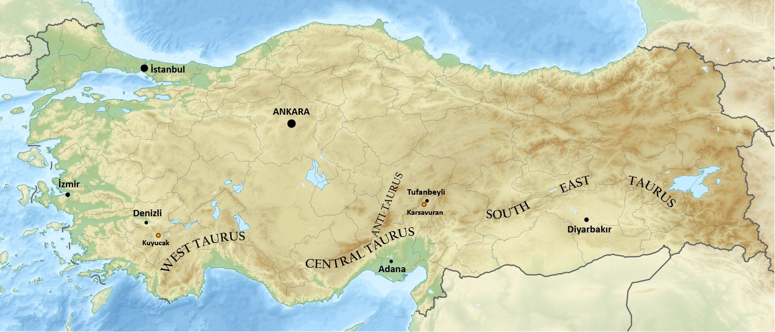
The head-on collision of the Arabian plate with Eurasia was focussed on Iran, itself a fractious nation, and the eastern region of Turkey. This thrust threw up the Zagros mountains. In Turkey, this range is known as the Southeast Taurus mountains, but geologically it is an extension of the Zagros suture zone. Westward, the mountain range bends from northwest to southwest, following the outline of the Arabian plate. The southwest-oriented section joins up with the north-south Dead Sea Transform: this completes the border of the Arabian plate.
The southwest-oriented section is the East Anatolian Fault. This 500-kilometer long fault was only discovered in the 1970’s. The movement along the fault is complicated with both compression and transform motion. Turkey is being pushed north, but the Eurasian plate provides strong resistance and Turkey can’t go that way.
There is a way out. To the west is the fractured southern shore of Europe. And because Arabia is moving north faster than Africa is, the pressure in the east is greater than the resistance in the west. 11 million years ago, Turkey began to move west. A fault formed which split the region from the Eurasian plate, and the Anatolian (mini)plate had formed. This fault is the infamous North Anatolian Fault. It is still forming but is already responsible for many of the strongest earthquakes in Turkey. Turkey is also rotating a little, and this motion has created the Marmara sea, often seen as the dividing line between east and west.
The next large earthquake in Turkey had been expected to occur on the North Anatolian plate, possible near the Marmara sea. But instead the other major fault failed: the East Anatolian Fault. And its failure was quickly followed by another one, on a nearby fault that had not been considered as particularly dangerous. The first earthquake had been predicted, as a seismic gap between active segments. The second one came as a surprise.
The East Anatolian Fault consists of some 10 separate segments, separated by step-overs. There are many other faults in the region as well, some running parallel to the master fault, some going off on angles. There are fault fragments in many places and it can be hard to know which one is the real thing! Precise locations are also not always easy to determine. This region hasn’t yet organised itself into a well-designed fault system. The connection to the Dead Sea Transform Fault is particularly complex.
The East Anatolian fault is the main source of the devastation of last week which will haunt the region for years to come. In the M7.8 shock it failed over a length of 300 km, more than half its total length. The second quake ten hours later hit a westward fault (Sürgü-Cardak Fault – the names refer to two segments of this fault) which failed over its full length of 170 km. This fault was known but not well studied.
The map below (adapted from USGS) shows the known faults (red). It also shows the two sets of recent earthquakes (purple and pink), and historical earthquakes (red). I have indicated in black the faults that failed, and in dashed lines a very approximate indication how they might extend towards and into the Mediterranean Sea – assuming the sea is better organised than the land! The dashed lines should be taken with significant caution. The connection to the Dead Sea Transform Fault is also quite unclear – in fact there isn’t an obvious connection in this map.

Why were these faults not better known? The East Anatolian Fault was recognized but it had not moved in this region for 200 years. People had forgotten it was there. The other fault is just one of the jumble of separate faults and fault-lets in a mountainous region. The land here is deeply fractured.

Source: Tamer Y. Duman and Ömer Emre, 2013, Geological Society, London, Special Publications, Volume 372, Pages 495 – 529
A more detailed map was published 10 years ago. It shows a (geologically) broken land riddled with faults. In this map, the East Anatolian Fault runs on the western edge of the Karasu Trough, and the Yesemek Fault runs on its eastern edge. The latter is seen as an extension of the Dead Sea Transform fault. Instead of joining forces, the two faults are competing, with both potentially active. In the future a triple point may yet form in the Amik Basin (AM) but at the present time, the fault system near Gaziantep makes a disorganised impression. It is a mess.
Faults of failure
The Sentinel spacecraft from the European Space Agency provide monitoring of the world in a variety of ways. One of these involves radar to measure distance between ground and satellite. Each area of the world is mapped perhaps once a week. The strip of land covering the quake zone was mapped on the Frday following the quake. There were clear and present changes.
The satellite was moving roughly south to north, on a track to the east of the quake zone (and several hundred kilometers higher, obviously). While it is moving, it measures distance along the track and perpendicular to the track. Note that this is the distance to the satellite. When the satellite is straight overhead, changes would be up or down – that is what we want to know when a volcano is involved. When it is far away, changes are mainly horizontal. But in practice, we are seeing a combination of the two and it is difficult to know what movement is up-down and what is sideways. Do keep this in mind when seeing such radar (or INSAR) maps.
North-south changes
The INSAR data above shows the changes from the earthquakes. These are the changes along the direction of the orbit of the satellite, which is almost north to south. Red is towards the satellite, i.e. northward. Blue is the opposite. The Arabian plate shifted north by around 2 meters, as shown by the orange colours. This motion occurred between the East Anatolian fault and the Yesemek fault, roughly 30 km to the east, and a fault zone that continues northeast from here. The indicated epicentre of the M7.8 earthquake was near the Yesemek fault. The main event was however on the East Anatolian Fault, as shown by the Sentinel images. (There is another fault zone closer to Gantiazep which could even have been involved.) The movement was mainly within the region between the two main faults. Interestingly, the Anatolian plate on the other side of the East Anatolian fault seems to have moved a bit in the opposite direction (south or down), as shown by the light blue colour.
It is a bit of guess work on precisely what happened. The East Anatolian Fault was locked. The bulk of the Arabian plate is still moving, in a continuous creep northward, driven from below. This puts an enormous stress on the area close to the locked fault. Several meters of movement had build up. A bit of the stress was transferred to the Anatolian side of the fault which had been dragged a bit north. When the fault failed, the stressed zone suddenly moved north along the East Anatolian Fault. This also released the stress on the Anatolian side, which moved back south a little bit. Do note that this is guess work. It also ignores the role of the Yesemek fault, any up/down movement, and the depth profile of the fault.
Note that there is no north-south motion visible on the Sürgü-Cardak Fault.

East-west changes
The second plot shows the movement perpendicular to the orbit of the satellite, i.e. roughly west-east. Now the picture is very different. The orange colours show movement to the east. Eastward movement is seen in the Arabian plate but only north of the bend to the northeast. The plate shifted as much as 2 meters in this direction. The combined motion is about 3 meters.
Now a strong effect is seen on the Sürgü-Cardak Fault. North of the fault the colours show a large westward movement, and south of this fault there is a smaller eastward shift. The westward motion is that of the Anatolian plate which is accommodated by the North Anatolian Fault. In this region, it seems to be distributed over other faults, one of which failed. The reflex motion shows that this was a locked fault where the north side was pulling the reluctant southern side along. The cause lies in the bend in the East Anatolian Fault. South of here, the push is to the north. North of here, the bending also causes a push to the west. This gradient in the force direction has led to this fault developing.
Photos near the East Anatolian Fault line after the quake show offsets of around 2 meters, consistent with the numbers above. The image below is from Hassa, around 30 km northeast of Iskenderun. The second image, from the same general area, shows vertical offset as well.
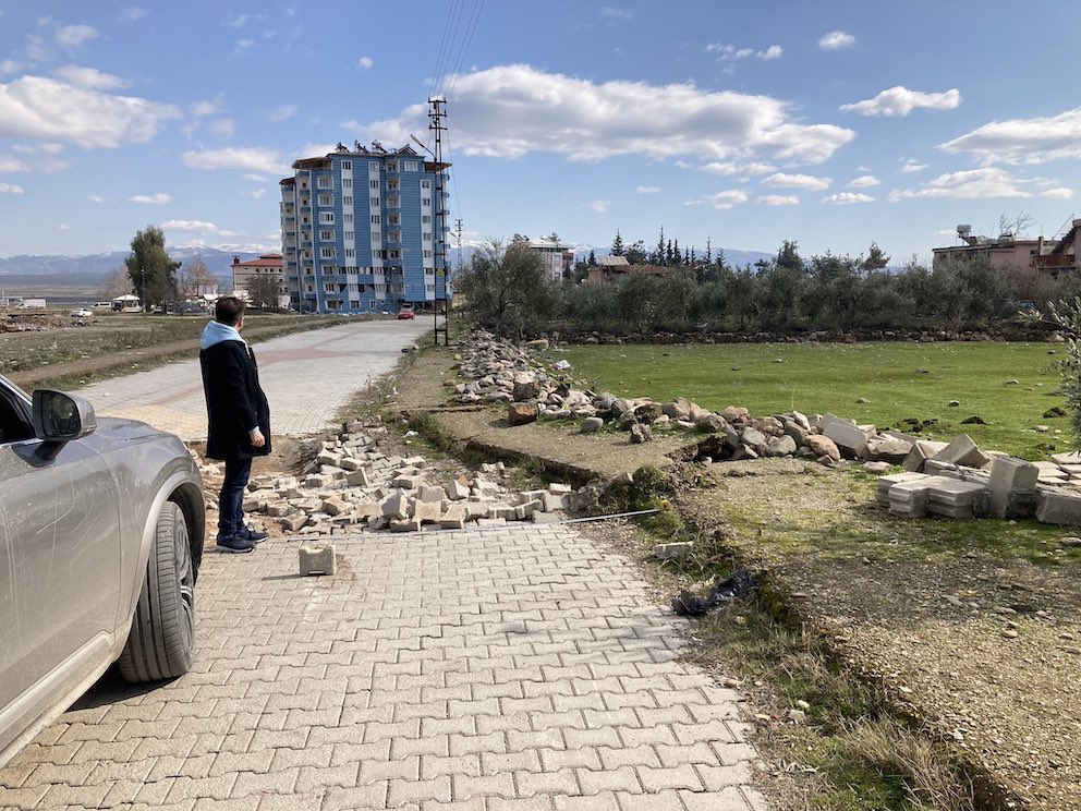
About 2 meter of displacement. The blue building is now very suspect, but it did protect the people inside. Good on the builders. Source Ozdemir Alpay
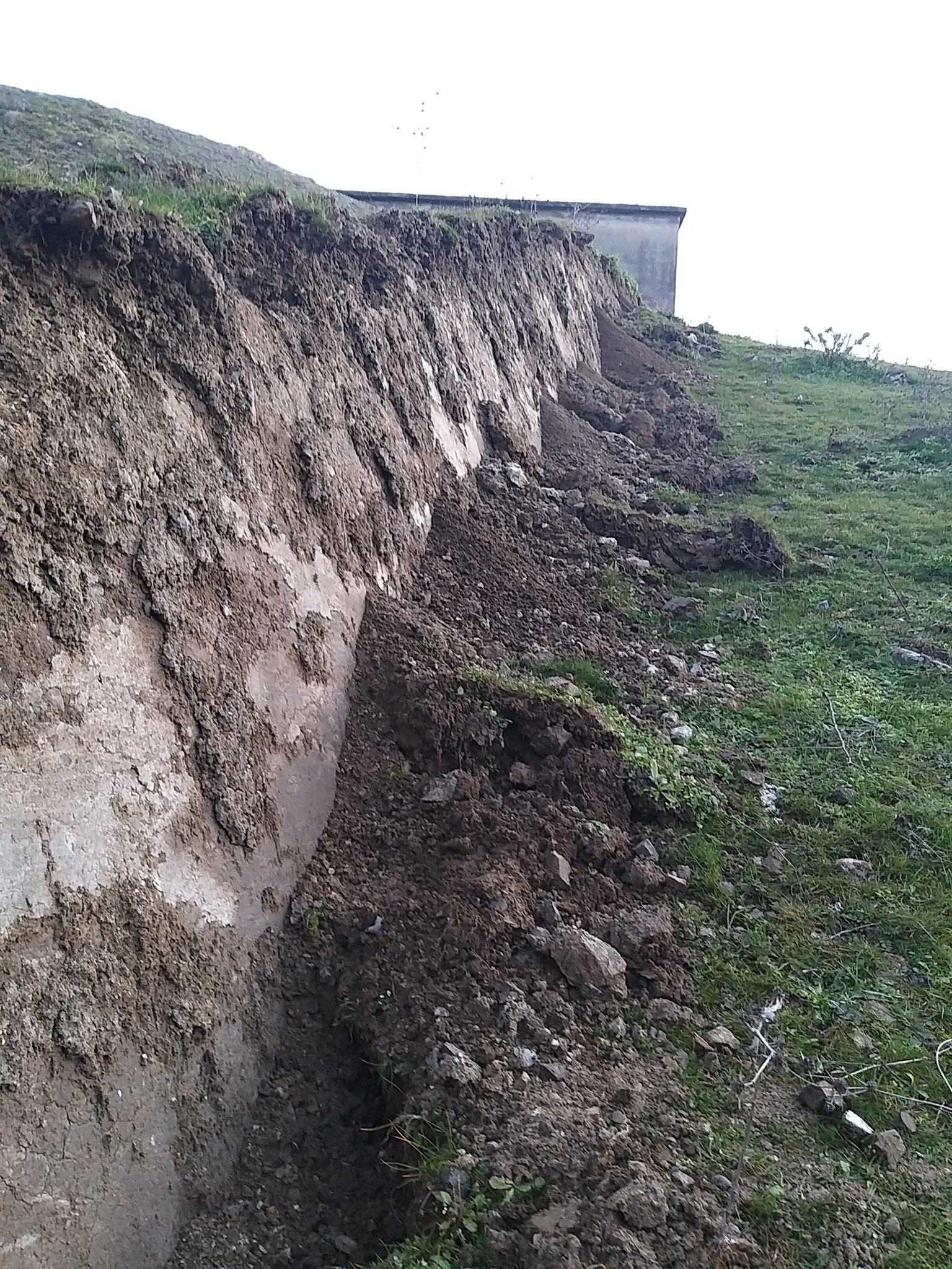
Earthquake vertigo. Source M. Korhan Erturaç
Iskenderun’s gulf
Further south, several faults run either side of the Gulf of Iskenderun (also known as the Gulf of Iskanderoon, Gulf of Alexandretta, Gulf of Issus and in the past as Armenian Gulf – it is a bay of many names). This is part of the Levantine Sea. The gulf-of-many-names seems to be a small pull-apart basin, caused by the enforced westward movement of Turkey. The East Anatolian fault runs though the Karasu Valley, and has pushed up a small mountain range between it and the bay, called the Amanos mountains. They are also known by other names.) Iskenderun is on the east side of this basin: it sunk by a meter or so during the earthquake, perhaps due to the pull-apart effect. This explains the photos of sea water flooding the edge of the city. Iskenderun is known for industrial air and water pollution: it could do without this additional problem.

The Gulf of Iskenderun, where Turkey pulls away from Arabia. EAF: East Anatolian Fault. YF: Yesemek Fault
History
The older earthquake history of the region is not as widely known as it should be. There are comprehensive catalogues but these are not publicly available. A few of the largest events are well known even to wikipedia, but just glancing at the wikipedia page shows how incomplete this is. Otherwise the main information is in research papers that use part of the main catalogue. The most comprehensive list is from Sbeitani et al, 2005, in the Annals of Geophysics, in a paper on historical earthquakes in Syria.
The information originally comes from historical documents. They may have been written long after, can exaggerate things, and be vague on details such as precise locations, dates or even the year. Nowadays, news travels fast. In those days, it could take weeks, months or longer for the knowledge to spread. Of course, there was no talk of epicentres in those days. There are descriptions of damage in various cities, but we need to guess which fault was at fault from which cities are mentioned and how severe the damage was. (Name confusion is also common. And Tripoli in Lebanon was commonly confused with Tripoli in Libya, giving rise to some very strange earthquake stories.) The damage may be overstated, especially if the documents were written long after the events, and damage reports may have a local bias: because a city was not mentioned does not mean that there was no damage there. At the extreme end, it could just mean there were no survivors! Neither do the documents give the magnitude of the earthquake. Where a paper claims that an earthquake say in 1300 had a magnitude of 7.2, this number is approximated from the area over which damage was mentioned and should be taken with care.
This area of Turkey has an amazing history, as so vividly described in the previous post. The cities are ancient. The two main affected cities in the region, Gaziantep and Aleppo, are among the oldest continuously inhabited cities on Earth. We should be able to find out when they were badly damaged in the past.
Gaziantep is a large city with 2 million inhabitants. It also has a long history with a large variety of rulers. There was a large Armenian community here but they left (or were exterminated) in 1915. Old documents refer to the city as Hantab or later as Aintab. It is at risk most from the East Anatolian Fault, but also from the Dead Sea Transform and even from the distant Bitlis-Zagros Suture. But there is little direct information available on past destruction. Reading papers on the history, it almost seems like the city was mysteriously spared. We know that cannot be true, but complete destruction seems to have been avoided. There were many research papers on the expected impact that a large earthquake would have on the city (one as recent as 2022), exploring earthquakes with assumed magnitudes typically from 6.5 to 7. The relaxed attitude in building standards that was evident last week was done in both full knowledge and denial of the danger.
Aleppo also is a city with much history. It may be 8000 years old. The city was called Halab; the current name is of Italian origin. For Aleppo we do have an extensive record of earthquake damage including a hugely destructive event in 1138. It is closer to the Dead Sea Transform, so is at danger from two sides: in many cases the source of its shaking is not in Turkey. Documents about damage in Aleppo sometimes mention damage in Gaziantep as well: these are the events we are looking for.
Antakya (Antioch) is yet another old city. It is further south and is affected mainly by the Dead Sea Transform Fault, with shaking amplified by the old lake bed.
Looking for earthquakes which badly affected both cities, the two top candidate is the event of 13 August 1822. It devastated the region between Gaziantep and Aleppo, including both cities themselves. It is well documented. It started as a series of weak foreshocks in the week leading up to August 13. On the 13th there was a larger shock, followed 30 minutes later by the main event. Aleppo was in ruins: 2/3rd of the houses were destroyed. It lost the wall of the citadel. Lattakia and Iskenderun were badly damaged. Fissure were reported in the area. The death toll is estimated as between 20,000 and 60,000, including 7000 death in Aleppo. The earthquake was felt across the Middle East. This earthquake was either on the East Anatolian Fault or on the Yesemek Fault.

There was another large earthquake in the region in 1872. This seems to have been centred further south, in the Amik Basin.
Going further back, less is known. There was a damaging earthquake in 1513 or 1514 but it seems to have been focussed further west, perhaps on the southern extension of the Sürgü-Cardak Fault. This however is disputed.
An earthquake in November 1114 is often mentioned. There were two strong foreshocks, on 10 August (perhaps off-shore in the Gulf-of-many-names) and on 13 November closer to Antioch. The main shock followed on 29 November 1114. It may have been similar to last week’s events. This earthquake completely destroyed the ancient city of Marash (modern Kahramanramas) with damage as far away as Aleppo. Contemporary reports claim 40,000 dead in Marash. That number seems a bit excessive as the population is estimated at only 5,000! The ruler, Richard of Salerno (a crusader), evidently also died in the earthquake. The city was an important fortress, but disappeared from records for at least 10 years. The earthquake caused extensive damage over a wide east-west region but cities like Gaziantep and Aleppo were apparently less affected.
Evidence for ground slip from the 1114 event has been found along the same Sürgü-Cardak Fault that failed last week: this fault was therefore the likely culprit in 1114. This may have been the last time this particular fault failed! The last evidence for ground slip here which preceded 1114 was from the 3rd century.
(There were other similarities with 2023: ‘When the shocks ceased, snow began to fall and the country was buried under thick blanket.’)
There is more to be found in historical records, but the problem is always to assign magnitudes and to know exactly which fault was involved. The segment of the East Anatolian Fault north of Kahramanramas, where it bends more to the east, had been quiet for a long time – we don’t know how long. The section south of this city may have failed in 1822, however it is possible that this was the parallel fault. The quietness of this section had been noted, and after the sequence of 20th century earthquakes further up the East Anatolian Fault, marching along the fault, the warning flags were up. An earthquake northeast of Kahramanramas had been expected. That section indeed failed last week, but the earthquake also broke the southern segment, and it triggered the Sürgü-Cardak Fault. That was unexpected.
Based on the limited evidence, the section of the East Anatolian Fault closest to Gazantiap may fail once every 200 years in large events, the Sürgü Fault once per 900 years, and the northern end of the Dead Sea Transform Fault perhaps once every 500 years.
The first number is most uncertain because of the limited record and the two overlapping faults. It has also been argued that either of the southern East Anatolian Fault and the Yesemek Fault fail only once per thousand years, as the slip rate is divided between them. That seems optimistic, though. The recurrence time in more northern parts of the East Anatolian Fault is around 190 years, based on a long record of lake deposits deriving from large events with liquefaction. This central region last failed in 1893, in an event estimated at M7.3.
The 2023 earthquake was exceptional because a much longer section of the East Anatolian Fault failed. The fact that two separate faults went in close succession is common in the region. The succession often involves faults further south, in the complex region where the Dead Sea Transform diverges into fault segments going off in various directions. That didn’t happen this time. Looking at the historical record, after last week there is possibly an enhanced risk of a follow-up event along the northern Dead Sea Transform, over the next several years. But that could happen in offshoots of the East Anatolian fault as well.
The Karasu Trough
The main earthquake followed the Karasu trough, a deep, wide valley filled with sediment. The cause of this trough is still disputed, but the fact that it is bounded on both sides by major faults must have something to do with it! One explanation is that both faults are slightly deviating from each other, causing a basin to form in between. (This is called ‘transtensional’.) The Yesemek Fault on the east side of the trough is seen as an extension of the Dead Sea Transform, a fault that has formed several deep basins further south, including the one that gave it its name.
The Karasu trough is about 20 km wide and 150 km long. The western side is steeper, and therefore the East Anatolian Fault on the west appears more active than the Yesemek Fault on the east. The Amanos Mountains are on this western margin and rise to 2 km above the trough. The east margin has a height of up to 800 meters.
Having two such major but independent faults run side by side seems unusual. It is possible that the East Anatolian Fault is still developing and feeling its way south, and may eventually take over the show.
Both margins of the trough show evidence for volcanic activity, with most eruption centres on the western margin. They are mainly cinder cones and basalt flows. Most of the volcanic activity is dated to around 300,000 to 400,000 years ago, but two of the cones near the central region are only around 50,000 years old. The lava composition is quite uniform, basalt with little crustal contamination.
The volcanic activity has been put to good use in the region. The Yesemek fault is named after the town of that name, in the Hatay region. Yesemek town is known for an ancient quarry where large stone sculptures were made. This quarry dates to the Hittites, and is 8000 years old! It used the basalt stone on the side of the valley for the sculpture. The quarry is now a monument. More than 300 of these sculptures have been found here.

Future
Predictions are best made in hindsight. Still, this section of the East Anatolian Fault was a known risk: it was a notable gap in the series of past earthquakes. A 2021 paper optimistically predicted that the strongest earthquake in the period 2020-2030 would likely not exceed M5.3. That was based on a time series analysis going back to 1900. But as James Jackson had noted for this region, already back in 2010: ‘The last 100 years are simply not representative for the longer period and give a completely misleading and unrepresentative view of the true earthquake hazard’. Other papers had predicted a significant earthquake in this region, and even mentioned the chance that the largest earthquake in Turkey for the 21st century would be on this section of the East Anatolian Fault.
I will quote Duman et al., Mediterranean Geoscience Reviews volume 2, pages 411–437 (2020):
Although, the individual fault recurrence intervals might be relatively long (e.g. 1000–3000 years), there are multiple–fault segments that can produce earthquakes at this rate (0.001–0.00033 per year). Therefore, the combination of activity rates from all of the low activity rate structures in the SMF system results in a significant rate of large magnitude earthquakes (0.007–0.0023 per year) in the Gulf of İskenderun region, which poses a significant hazard to infrastructure in the area.
The faults in this area of Turkey are strongly segmented and each segment can cause a strong M6 to low M7 quake. But several segments can fail together, causing a much larger event. This happened last week.
Both faults that failed will take a long time to rebuild the stress. Duman may be optimistic about the recurrence times, but for the East Anatolian Fault, it may be 200 to 300 years, or even much longer. For the Sürgü-Cardak Fault, it may indeed be a millennium. The same event will therefore not repeat any times soon. But the chance of earthquakes further west and south continues as before. There are many faults in this region. Even when each individual fault only has a small chance of failure, there are many other faults in this fractured country – some well known, others seemingly dormant. A fault that has been locked for centuries may be innocuous, or it may be ready to fail. The risk analysis should take the combination of all these faults and their individual segments into consideration.
Turkey has now had two major quakes with tens of thousands of fatalities in the last 25 years. Both of these earthquakes had been predicted. For Turkey’s faults, failure is not an option – it is a certainty. It will happen again. And again.
Elsewhere
It is not only Turkey. There are other places in the world at risk of slow recurrent failure. Turkey has an ancient history, which helps in recognizing the dangers, although apparently knowing the danger was not enough. Other places may lack the long memory. One of my most sobering drives was along the San Andreas fault in southern California. Primed and ready to go – and still people build houses only meters from it. Humanity is like that.
Albert, February 2023


Thanks, very interesting. Just the context I was looking for.
With rebuilding costs projected in the tens of billions, a reminder to consider donating to the relief effort if you can. https://www.dec.org.uk/appeal/turkey-syria-earthquake-appeal is as good a place to start as any.
And TIL: just why the Dead Sea is down where it is. I had no idea, so thanks for that also.
Thanks Albert for another timely summary with lot’s of new info to digest (for me, anyway).
The stress transfer/shadow will be interesting to monitor over the following years…and I wonder if our current models for coulomb stress transfer can be trusted?
Given the combination of both vertical and horizontal energy release from these coupled events, I would imagine that much of southern Turkey/NW Syria has seen some amount of stress change.
It’s my view that stress transfer/release must be quite different for vertical displacement vs. lateral/transform motion. In lateral motion, land ahead/behind the slip will directly feel the “push” or “pull” from moving land (kinda like a slowly moving railroad train with cars made of rubber periodically lurching over a log lying across the railroad tracks) …while energy in a surface-expressed slip is released to open space or into more ductile rock at depth…i.e. energy more efficiently dissipated with less direct energy transfer to adjacent areas.
The surface fissures from the second quake are beginning to appear. They may have been covered under snow before?
https://www.bbc.co.uk/news/av/world-europe-64624691
Good read Albert. This area is so complex from a tectonic perspective it’s a bit mindboggling.
On an unrelated note to the original post, picking up from some conversations on the previous post, I’m rather curious if there are any patterns or behaviors in a volcanic system that would potentially indicate that a volcano is evolving into a potential large silicic caldera system.
An exerpt from a paper on Toba’s history and evolution stands out to me: “They interpreted the HDT to represent a Crater Lake type caldera eruption from the large pre-caldera stratovolcano that had previously erupted the underlying andesitic lavas…. The strong crustal signature of the HDT and the conformable older andesitic lavas indicates that a deviation from typical magmatic evolution of mantle derived melts was underway at Toba at this time.”
From http://www.aquacase.org/ongrowing/tilapia_regal_springs_sumatra/docs/The%20Toba%20Caldera%20Complex.pdf
Basically, this highlights what I have always been incredibly curious about. Is there any way to distinguish what a potential VEI-8 eruptor would look like if it hasn’t already had a prior VEI-8 or large VEI-7 sized eruption before? Can they evolve from basic stratovolcanoes into large caldera systems? Would they resemble more of a monogenetic rhyolitic volcanic field as Hector has mentioned before? Clearly we’ve seen many VEI-8 caldera systems erupt multiple VEI-8 sized eruptions – this much is observed from Yellowstone, Toba, Taupo, etc. But for each one of these systems, there was a first time for their VEI-8 eruptions. And in those instances, if we could time travel back to before they erupted, it may not have been obvious what the potential of those systems were.
My thoughts on the Kyluchevskoy group being a potential supereruptor in the distant future doesn’t seem to be validated by the current magma composition. At the same time, other traits mirror many seen in these large caldera producing regions. What I wonder is whether that is just a product of bimodal volcanism with a potential buildup of unerupted evolved magma not being able to be measured. Or separately, if there is simply a natural potential for progression into more evolved magmas over time.
I notice in a few instances that it seems crustal assimilation seems to be somewhat of a common theme in these types of volcanoes. But I wouldn’t assume that’s a rule, but perhaps one way to get from point a to point b.
Clearly I’m not an expert here, but these are always the questions that keep me perpetually interested in volcanoes.
To the question of how these systems would’ve looked like before they became the beasts we’re familiar with, I think there could be a wide range of solutions. A group of rapidly growing separate volcanoes could merge in to one massive volcano.. I think the Cerro bravo complex could be an example of this, even after the volcanoes merge, it might be to well ventilated for a massive eruption for some time. Stratovolcanoes could actually get plugged for 100,000s of years forming a large system underground (CCN)
fhttps://www.volcanocafe.org/the-missing-piece-part-2/
In any case, the formation of these systems are inevitably the result of demand not keeping up with supply.
I imagine they begin as a normal stratovolcano that collapses, but then instead of building a somma volcano it does resurgence and ring fault eruptions of crystal poor magma (seems often rhyolite in large examples but small calderas have any composition). It might go caldera again but larger next time. After a few goes the next eruption is a VEI 8. That is what happened at Aso, and that last VEI 8 might have reset things back to the beginning again. Also what that article says about Toba.
So any place where there are very large stratovolcanoes and a mechanism for accumulating magma could evolve into a supervolcano but it seems unlikely that they just spontaneously happen at that scale first time, at least not typically. But just my speculating
You have to look underground. It is not easy to keep that much eruptible magma in storage. The crust needs to be strong enough to stay intact over a very wide chamber. So the magma needs to be fairly deep. An extension region would help to keep the stress down. A VEI-8 is not just a bigger VEI-7. It is a different beast
Not sure that is strictly a thing. A ‘small’ VEI 7 can be from a stratovolcano but a VEI 7 of 990 km3 is basically an 8 that stopped a bit early. The effective eruption rate of ignimbrite might be pretty capped, onviously a bigger caldera has a longer ring fault so the total rate can be higher but I cant imagine a VEI 8 is more instantaneously powerful than what Hunga Tonga or Taupo was at a comparable length. Its like setting of 1 MT nuke or two 1 MT nukes, one scenario give twice the explosion in total but doesnt make each explosion twice as powerful, just more of them.
It is hard to know what a volcano may have looked like before caldera collapse, given that the caldera collapse obliterates everything. However, it is true that VEI 7-8 calderas are always rhyolitic or dacitic, or in intraplate/alkaline regions sometimes trachytic or trachyandesitic (alkaline equivalents of rhyolite and dacite). A big silicic magma chamber will take time to grow and it will probably erupt while it grows, and even when complete it will probably not collapse immediately, but do effusive silicic eruptions and smaller explosive events before the grand collapse. So I think chemistry is the most important thing to look at. Most volcanoes in volcanic arcs are andesitic, basaltic-andesitic, or basaltic, even viscous looking lavas are just crystal-rich basaltic-andesites and andesites. For example, Merapi despite being a terribly dangerous volcano with very viscous lavas is in reality a basaltic andesite volcano with 51-56 wt% SiO2. So it is not a matter of viscosity but of the whole-rock chemistry of the lavas erupted. Those that do have dacites and rhyolites may have a silicic storage zone that could grow into a caldera. The area spanned by this silicic activity should show more or less how big is this storage area, large calderas, like Yellowstone or Okataina, erupt rhyolite from vents that are up to tens of kilometres apart from each other.
I will put two examples of emerging systems that probably have a caldera potential but have not collapsed yet: Clear Lake, and Three Sisters.
Clear Lake is a massive field of andesite, dacite and rhyolite lava domes. It covers an area from Clear Lake to south of the City of Napa, a total length of ~100 kilometres, as big as Toba. That doesn’t mean all of it is in an active molten state, but even a fraction of it being molten rhyolite-dacite would already be a monster system. It is also a tremendously powerful heat source, sustaining the world’s largest geothermal plant complex (see Wikipedia). It is in an area of “supervolcanoes”, with Long Valley being 300 km to the east. Also Timber Mountain is 500 km to the east, which is a 30 km diameter caldera that did four ignimbrites, each with ~1000 km3 of rhyolite-dacite, within less than 2 million years, about 12 million years ago. And 6 Ma Silver Peak caldera, which is between Long Valley and Timber Mountain, is also a monster.
So there is plenty of evidence Clear Lake is a nascent silicic system, probably capable of VEI 7-8 eruptions. As far as I know, there wasn’t any big volcanic complex before the silicic activity started. Clear Lake has been a felsic volcano from the start, although I would need to look more closely into this system to know for sure. So it’s a sort of “spontaneous supervolcano”, something regions with large scale felsic volcanism can probably do.
Then there is Three Sisters, which is a complex of four stratovolcanoes of basalt and andesite composition that has recently started erupting fissure fed rhyolite lavas over an area 10 km across centred around one of the stratovolcanoes (South Sister). InSAR shows inflation under the west flank of South Sister with a similar diameter to the extent of the rhyolite activity. So here we have a Crater Lake situation, a stratovolcano (South Sister), that has developed a magma storage under its flank, and will probably go caldera at some point, this is probably a more typical volcanic arc case, but with a system of much smaller size than Clear Lake.
Thanks, and I remember your article on a similar topic from a while back (specifically pertaining to mexican volcanic systems and rhyolitic volcanism).
The cascades are interesting, especially the back-arc type volcanoes further to the east of the primary front. Specifically, Medicine Lake, Newberry, and Lassen. All have a similar profile of being past caldera eruptors with bimodal type magma systems. And as is common in the “profiles” of similar large caldera systems, they all sit within zones of extension (often continental back-arc spreading regions).
I somewhat wonder if the progression of a volcanic system from a more mafic origin into more felsic would be a signal that a volcano is potentially evolving into something larger and potentially more explosive.
Thanks, the Cascades is indeed very interesting. Completely different eruption style from most subduction zones. South of Saint Helens the stratovolcanoes become very sleepy, most of them are dissected and small. In place of stratovolcanoes you get a lot of monogenetic volcanism, ranging from cinder cones to steep sided shields of mafic-intermediate lavas. These shields are enormous (for being monogenetic structures) and distributed all along the arc. And then you have the two basaltic-rhyolitic polygenetic shields of Medicine Lake and Newberry. They are pretty unique volcanoes with no counterpart elsewhere in the world. Medicine Lake is probably a very substantial silicic system, with rhyolites being erupted 15 km away from each other. And the basalts of Medicine Lake and Newberry are very fluid, making extensive flows with pahoehoe lava and long lava tubes. I don’t think you see such fluidal lava textures in any other volcanic arc. It is probably a very dry arc, apart from having active rifting and also being part of the same basaltic province as Yellowstone (the High Lava Plains and Snake River Plain make a continuous basalt plateau to Yellowstone).
Newberry and Medicine Lake seem to have episodic volcanism. Both have an average interval of probably one eruption a century in the Holocene but in reality often go millennia between, with periods of intense activity. The biggest eruptions at both are huge, both basaltic and rhyolitic. Medicine Lake also has some fluid flows of andesite composition, showing there is time to settle crystals and the volcano has a very hot interior.
It is unfortunate that historical time in the Cascades has only a few eruptions, and all from the stratovolcanoes. Seems like everywhere had lots of monogenetic basalt eruptions very often until recently.
Actually, considering how abundant monogenetic volcanoes are in the Holocene there really havent been many in the past few centuries, even worldwide Paricutin and Jorullo are the only substantial ones that are their own thing I am aware of. I suppose Pu’u O’o could be considered but that was a satellite of a polygenetic volcano. I guess in terms of surface appearence it is impossible to distinguish a flank vent of a polygenetic volcano with a distinct vent in a volcanic field…
Monogenetic eruptions are often very voluminous. Paricutin itself erupted 1.3 km3, and that was a mid-sized or even small eruption. Places like Mexico, the High Cascades, some Turkish volcanic fields, Arabia, Australia, or the Chinese volcanic fields do eruptions that often reach several cubic kilometres, or even up to 20 km3. Such eruptions are so big that they are very uncommon. A small volcanic arc will erupt something like 1 km3/century (this is more or less the long-term eruption rate of the Marianas) so of course major monogenetic eruptions will end up happening centuries or thousands of years apart in the locations where they happen. Stratovolcanoes erupt much more often because the volume they erupt in each eruption is insignificant compared to monogenetic volcanism, and when they do erupt substantial volumes is through long period of semi-continuous effusion that last decades or centuries.
Other than Paricutin, Mayotte and Surtsey are the monogenetic volcanoes of the past several decades.
The volcanic fields I was thinking of above are in Armenia, not Turkey. The ones in Turkey are mostly central polygenetic volcanoes..
Something interesting about Clear Lake. If you look at its geochemistry, it is very similar to large silicic calderas of the US. I once downloaded from GEOROC chemical samples of lavas with less than 0.5 weight percent magnesium oxide, this is melt that has evolved to its maximum crystal fractionation degree, thus losing virtually all of its magnesium, which is the major element that crystallizes away fastest. This includes magmas such as rhyolites, trachytes, phonolites, and also evolved interstitial melts in crystal rich magmas (like a crystal rich andesite with rhyolite in between the crystals). If I compare the chemistry of Clear Lake to other volcanic systems of the US with highly evolved samples, it shows an affinity to the “supervolcanoes”, Long Valley and Yellowstone. While the smaller silicic systems have a different composition. It looks like a long-term thing of the US. Old VEI-8 calderas such as Timber Mountain and the Nevada calderas of the Mid-Tertiary flare up (one of them plotted in the graph) also match this same composition that is rich in potassium and low in sodium. It is not the same elsewhere though. The Central Andes and Toba also have this composition, but the TVZ and Kyushu do not.
Clear Lake might be the next major US “supervolcano”, I believe, and might be a good oportunity to study an embryonic system of these characteristics. Even if it is not an embryonic VE-8 system it is still probably related to them.
This is great work. Long Valley is quite a wide range, I imagine the less evolved magma is more predominant towards Mono-Inyo compared to the rhyodacitic Mammoth Mountain.
Yes, I was also curious about Long Valley and its unusual distribution of the data. It can’t be very well appreciated, but Long Valley has two different trends, although I did not check if they were associated to particular events or locations.
All the samples in the graph are in the same evolutionary state, are as evolved as it gets, so differences in composition owe to chemical particularities of the magma that feed these volcanoes. From what I’ve seen so far, major caldera clusters tend to have the least sodium and most potassium of all volcanoes around, although how much these values are exactly changes depending on the location, generally being more potassic the more alkaline the magmas of an area are.
As always a great read Albert. Could you shed some light on the possibility of a bad earthquake in Cyprus? Your title in this article suggested that the next event could be there. I want to know if Cyprus is a good bet to retire too. Or will it be a case of being woken and put to sleep permanently at the same time?!
No pressure – just predict earthquakes! Your chances are good compared to Greece or Turkey. There are strong earthquakes there (Cyprus), especially on the west side, but not frequent. The last big one was 800 years ago. As for the future, it depends on when you want to retire. In a million years from now things could get more exciting.
In the area of the Cyprus arc the Anatolian plate is moving much faster westward than the African plate is moving northward, so earthquakes are more likely to be strike-slip than subduction in this area. The bulk of the Eurasian plate is to the north so it makes sense that there would be a slow-down, and indeed it is this difference which caused the African plate to tear itself apart.
North and central Cyprus (Nicosia etc.) would be relatively safe, but somewhere like Pafos or Limassol (with the seafront massive skyrises) could be at risk.
Nice place, but I went at the wrong time of year when everything was still being done up for the summer.
“Do note that this is guess work.” Good guess work mostly, coming from you, Albert. Thank you for the detailed background. Must have been a piece of work.
Devastating death toll.
Have been absent as of late, my apologies. It has come to my attention that Askja is having a RAPID melting of the ice cap in the last few days. Is there any news beyond that?
Yes there is also a small quake swarm there now too. Seems a likely bet for an eruption now but nothing official just my guess 🙂
Will probably be a basaltic fissure eruption along one of the caldera ring faults, but if that is in the lake and of high intensity it could get a bit dangerous. It is winter though so the weather is more dangerous than the volcano.
The speed at which this intrusion has appeared means the magma is basalt, probably a sill under the caldera. There wasnt much rhyolite in 1875, it was a VEI 4 just a very powerful one, probably some variant of a maar formation, the caldera was a typical slow collapse like Kilauea and Bardarbunga.
There’s even a handful of quakes, albeit small ones, in the area towards Holuhraun. Apart from the Upptyppingar swarm in 2007 and the intense seismic activity during the Holuhraun eruption, this area is usually as silent as the “dead zone”. There’s no doubt that pressure is increasing under Askja. If (or when) magma actually decides to go for the surface I expect the intensity of the earthquake swarm to go up a couple of magnitudes.
Really most of Iceland is ‘dead zone’, the only places that get lots of quakes outsideof eruptions are on the transform faults.
Just my take but I dont actually think there is any magma under the aseismic areas, just that it takes some time to accumulate enough strain to break the rock following a rifting event. Dikes intruding are very seismic, as we saw on Holuhraun and even more so in Hawaii these past few years. Laki was also extremely seismic, for weeks before the eruption it was bombarding the south of the country with powerful quakes, if it happened today we would not have any doubt what was happening.
Seems at least this is going to be a sizable eruption. But it wont be a massive eruption unless it rifts, and though there was rifting south and north of it the interval of 150 years might not be long enough. Eruptions in the caldera can be impressive though, along the whole western edgeo fthe caldera is a line of fissures all under 1000 years old and with fountain heights exceeding 300 meters, which is very tall for a fissure eruption (Mauna Loa was only 100m on its first day last year, didnt get any higher until near the end).
So my guess on what will happen is a large basaltic lava flood eruption but only within the central volcano, perhaps flooding the caldera and if things get really extreme or evolve into a longer event then Oskjuvatn may be destroyed, but that wont be a gone-in-one-day thing. Askja has been very active in the last 1000 years just it wasnt ever observed until 1875. The area that oskjuvatn now occupies might have been a lava shield, which dates after 1158, guess it had a pocket of magma that sat and turned into rhyolite. This map shows very well the recent activity.
Nothing really huge recently but all of the lava is a’a with some pahoehoe on channels or near vents, eruptions at Askja central volcano seem to be extremely intense with very high effusion rate, like the Galapagos volcanoes or Mauna Loa. Although that might also mean if a webcam isnt set up we might miss most of it before anyone gets there 🙁
It’s not a good time of the year for a volcano watching eruption to happen there. The location is about as remote as you can get in Iceland. Webcams will be notoriously difficult to set up and maintain (queue angry complaints about the stream going down, etc). Physical access will be limited to helicopters and those huge modified 4×4 SAR vehicles. Let’s keep our fingers crossed it has the decency to wait until summer before it goes off.
Weather in Iceland is probably more dangerous than any volcano there really. I dont think more than a few hundred people have actually been killed by volcanism there directly, maybe even less than 100.
Might not necessarily be just one eruption though, there might be a series.
I wonder if Starlink works that far north, no more connection issues then.
Connection is probably not the main issue. You need a power supply for the equipment. I think that’s what most often failed during the Fagradalsfjall eruption.
Laki exists and is extremely disappointed in your statement.
No one was killed by the eruption though, the deaths were from famine after but probably most of the missing population were not casualties but left Iceland.
If all the deaths abroad are counted then one might as well add everyone in Europe who died in the next decade was indirectly killed by the eruption, and everyone who died in the French Revolution. Gets silly after not very long. If Laki was in the 19th century there might be better data on its actual effects to people. But given there have been 3 effusive eruptions in the past decade that are within the same order of magnitude SO2 emissions and caused no more than a relative inconvenience it doesnt seem as dangerous as the legend suggests. In relative terms being on the Kona side of Hawaii in 2018 was way more concentrated vog than the Laki plume was by the time it reached Europe, but had relatively little impact.
Long answer short it is very ambiguous as to deaths attributed to Laki being real or caused by other environmental effects that may or may not have been influenced by the eruption.
There hasn’t been a single eruption in the ball park with Laki in the past 200 years nothing has even come close. The lava didn’t come up nice and steady like recent eruptions most of it came up in violent episodes that just lasted a few days. Just one of Laki’s episodes were bigger than all of effusive eruptions with plenty ash associated with it. https://agupubs.onlinelibrary.wiley.com/doi/10.1029/2001JD002042
Data shows that the volcanic winter associated with this eruption was likely more intense than Tambora, albeit not as persistent
https://agupubs.onlinelibrary.wiley.com/doi/full/10.1029/2020JD033544
This eruption killed 1/5 and 1/6 of the populations of Iceland and Egypt and aggravated famines that killed millions. The largest producer of sulfate for the NH, this eruption was an absolute unit, punking all our recent kitty effusive eruptions,
Can’t separate the volcanic eruption from the volcanic winter and the volcanic gas.
Eruption of Mauna Loa in 1950 was much higher intensity than Laki, I have looked at the numbers for both. In fact the beginning of most Mauna Loa eruptions is like this, and same is probably true of the opening stage of Galapagos eruptions. So no it isnt strictly true nothing like Laki has happened in the time since.
It is also notoriously hard to actually prove a volcanic winter is actually that and not some coincidental crazy weather when it isnt in observed history with modern instrumentation. There can be made a strong argument but outright proof is almost impossible. I also would argue volcanic winter is still more of a meteorological phenomenon outside the direct vicinity of the volcano either way, it is probably a good idea to separate it slightly from the immediate effects of the eruption itself when considering the impact, the response to them is very different.
In terms of fatalities directly from an eruption Iceland has very few for how long its history has been and how active it is.
There was a high death toll due to sulphur poisoning. It is estimated at 20,000 in the UK. Iceland must have been badly hit but the number of fatalities there is not known. The number that is quoted is the population decrease before and after, but that includes migration. There was no volcanic winter: there is no proven relation between the cold winter and the eruption. The hot summer is more likely related to the eruption: tropospheric sulfur has a warming effect. That affected the Atlantic basin. What do you call ‘direct fatalities’? Is that only from lava? From lahars? From tsunamis? From sulphur? Starvation? The line between direct and indirect seems open to interpretation
My use of direct fatalities is due to physical aspscts of the eruption. Being caught in a flow (lava or pyroclastic), hit by a lava bomb, washed away in a lahar, things where the actual eruption itself is immediately responsible. SO2 poisoning is kind of straddling the line. But SO2 turns into sulfate particulate within 50 km, the vog at Kona is mostly particulates not SO2. The particulate in ashy eruptions might be mostly CaSO4/Na2SO4/MgSO4 etc, but effusive eruptions could be H2SO4 which would be dangetous if allowed to accumulate somewhere although I dont know if it would be outright lethal at a distance.
I do wonder though, Kilauea in 2018 did something I have never seen discussed in the context of eruptions before, it created a very powerful pyrocumulus cloud, which probably scrubbed most of the SO2. It might have been the most intense rainfall at a single location we have ever seen actually anecdotally it was much more than Hurricane Lane just afterwards, which set a new record in Hilo (that alone is noteworthy). This might be a feature of many eruptions like that at a lower altitude in proximity to water but not in it. Mauna Loa is too tall so its vog goes far and wide. Nowhere in Iceland is anywhere near as high as Mauna Loa though, and it gets pretty wet at times. Just bringing it up.
There are many documents about the sulphur cloud over western Europe during Laki. (Not that the people knew it came from Iceland!) They describe the haze but also how it poisoned and killed the plants and crops. The excess death rate in the UK is known, and it happened among farmworkers. Kilauea is not a good comparison. Laki was a different beast
There’s more to an eruption than peak discharge rate, when Mauna loa chugs out 2 cubic km of magma in less than a week then we have an apt comparison
No Volcanic winter? if anything the heatwave was more likely to be caused by natural variability than the cold winter. The cold winter being caused by Laki has model support and makes more sense logically. This eruption would’ve had a strong radiative impact and there is no rule that volcanic winter is prohibited from touching a season with cooling.
It seems a bit hasty to potential write off volcanic climate effects with the saying “it’s possible that this could’ve happened without the eruption.” Volcanic winters aren’t hard to prove, we have the correlation AND the causation so what more do you want? Volcanic winter conditions(with no volcanic eruption) for regions, let alone the entire globe while possible, are extremely unlikely and it’s absurdly more unlikely that these conditions would happen within a year of very large eruptions on a regular basis.
With the climate, there multiple different ways you can get the same result but things are pretty regular when it comes to cause and effect. If you have an record smashing atlantic hurricane season during a La nina year, it would be safe to say that the La Nina was huge factor for the activity.
Im going to write an article on it for more clarity but the rate of magma flow in the Mauna Loa 1950 eruption was on the order of 0.2 km3 in 6 hours, which is about 4 km3/week, most of the volume of the eruption was in the first day. If the eruption happened low down on the volcano it would have likely been a multiple km3 event and in fact that actually did happen in about 1700.
Laki is noteworthy for the volume and the length of time it could keep a high rate but its intensity was not in excess of what we have seen before and what other volcanoes can do.
My cpmparison to Kilauea was for the distance where SO2 becomes solid sulfate paryicles, which should be pretty similar regardless of rate of emission. So the haze over Europe was not SO2 but probably H2SO4.
Blimey its a long way up to find the ‘reply’ button!.
Definition: Deaths due to an event include deaths caused that would not have happened without the event.
So earthquakes count deaths in buildings and deaths due to starvation (historically important). Deaths due to volcanos include those who die who would have been alive without the eruption.
That much is obvious.
Direct deaths has several definitions but one might be those killed directly due to contact with products (solid) discharged from the eruption.
It ,may include local poisoning by emitted gasses (acute) or later deaths due to the effects of gasses (eg fluoride/starvation etc).
It may include global effects if you care to define it so.
So the answer is, define your “deaths caused by” before stating the number.
Yes, there can be differing opinions of what should count. Laki killed no one directly. If anything, were people back then like us today they were probably fascinated by it as much as terrified, probably watching the 700 meter fountains in awe, the raging lava flood in the Skafta canyon, the relentless slow advance towards the church. It was only after this went on for a few weeks and never let up things got really serious. However, there is an argument that vog is only partly a volcanic phenomenon and is also weather related. The vog was not necessarily going to reach Europe but weather conditions allowed it.
I found this interesting thesis in which the author goes through the number of deaths noted in parish records to check for evidence of increased death rates directly linked to the Laki dry fog. It also goes through in detail the general living conditions during that time and the risks of dying from disease and malnutrition. It also includes a number of other disasters form comparison.
The final conclusion seems to be in agreement with chad’s point of view:
“Was Laki the villain or the fall guy? On the evidence presented in this thesis, it can be said that on the world stage, Laki was definitely the villain. However, on the current evidence, in Britain certainly, and Continental Europe possibly, Laki was, without doubt, the fall guy.”
https://theses.hal.science/tel-03533049/document
Thank you Albert for this one … Im too is writing my own article its about my Etna visit and summit crater climb, been inside voragine a few years ago. And took many fantastic Photos I wants To put up on VC in an article
Europe in Miocene was very diffrent .. Subtropical jungle like Bengal swamp with a gradualy drying towards pliocene. Europe in Miocene climate Optimum was populated by Subtropical and even tropical lifeforms, apes and tapirs where common, If humanity keeps pumping out CO2
If humanity keeps pumping out CO2 We will turn Europe back into that
https://m.youtube.com/watch?v=gut2yGGlPVE
Nice vid of carbonatite lava in Lengai
https://www.usgs.gov/observatories/hvo/news/volcano-watch-comparing-crises-mauna-loa-1984-vs-mauna-loa-2022
Mauna Loa last two eruptions compated. 1984 was about 50% larger, which makes some sense given the flow field is bigger and at lower elevation. Unfortunately they use gallons as a measurement…
1984 was 58 billion gallons (219.5 million m3 / 0.22 km3)
2022 was 40 billion gallons (151.4 million m3 / 0.15 km3)
Kilauea has so far erupted about 44 billion gallons (166 million m3 / 0.17 km3) for reference to a more easily visualized volume.
So if Mauna Loa has the same supply rate now as it did before it might take 20 years to erupt again. But there are a lot of variables.
I’d guess that we compare the eruption of 2022 with those on the same part of the East Rift Zone. It was an eruption high on the ERZ close to the summit region. The location let the lava run towards the saddle between Mauna Loa and Mauna Kea.
1935-1936 (forty days) and 1899 had similar positions on the ERZ but indeed reached the saddle. Both were smaller than 2022, if the numbers are correct (0.08 to 0.09 km³). They were followed first by a summit eruption (lava lake) four to five years later and second by a large rift zone eruption another two to four years later. If – only if – this is a pattern, the next eruption will be around 2027 in the summit caldera with lava lake.
1840-1950 Mauna Loa had higher supply rate than now, and possibly also higher than Kilauea in that time too. It was definitely getting nearly all of the plume from about 1930 to 1950, and also from 1850 to 1868. That might be why the biggest eruptions were in these decades, although all if Mauna Loas eruptions are pretty big.
1935 also had a north flank vent, the flow from that one reached the saddle, but the rift zone flows didnt. 1899 flow on some maps is much bigger than it really was, the actual flow is very similar to 2022. The cone immediately next to fissure 3 was an 1899 cone.
Mauna Loa reinflates rapidly after eruptions, did that in 1984 too. So the fast inflation now might nit mean anything. If Kilauea slows down a lot I think that is more meaningful. But that isnt happening now, if anything it is higher than before with how much surface activity there is.
There also were broken trends too. between 1900 and 1930 there were eruptions in 1903, 1907, 1914, 1916, 1919 and 1926. Of those, 1903 and 1914 were at the summit, the rest were on the southwest rift, including the 3 in 10 years from 1916 to 1926, with no gap between.
There was also a SWRZ eruption in 1887 that directly followed the eruption on the NERZ in 1881, there isnt any certain mention of a summit eruption in or shortly before 1887, and after last year I am not convinced any eruption on Mauna Loa could actually go unnoticed, it is the centerpiece and tallest point on the island, visible from basically everywhere.
Maybe most importantly, all of the eruptions after 1950 have broken this trend too. 1975 was a summit eruption but there was almost a NERZ eruption too. 1984 is described as a delayed flank eruption from 1975, but it also began at the summit all on its own anyway. And now in 2022 the eruption trended down the NERZ again, with no prior summit eruption.
I guess it comes from the fact that if a summit eruption happens then it doesnt relieve pressure, whether that be at Kilauea or Mauna Loa, so a flank eruption will be expected. But that correlation doesnt mean that flank eruptions cant follow each other either.
One thing that is important is that Mauna Loa eruptions and intrusions all begin in its summit area, with possible rare exceptions for some radial vents (my theory, not official). Kilauea has got the same magma chamber as Mauna Loa, a massive chamber under the broader caldera. But Kilauea has at least a dozen smaller magma chambers above this along most of its subaerial extent, and each of these can erupt somewhat independantly, they can all be considered satellite volcanoes in a way. The main summit chamber probably only directly erupts in LERZ eruptions, and maybe only those which involve south flank movement that opens up deeper pathways. By contrast all of Mauna Loas eruptions are like this, might be why long lived eruptions on Mauna Loa outside of its summit are rare but Kilauea does this frequently.
An exciting and thrilling story of Anatolian geological background! The Anatolian micro-plate and -continent is a continent of earthquakes, faults and fold mountains.
The geological position mirrors the political history. 1114 this area was the border between Eastern Roman empire and Muslim empires. Before often Rome and Persia there disputed their borders. The East Anatolian fault also borders to the Euphrat region, where historically the Semitic high cultures of the Akkadian Empire developed which might have inspired some of the biblical stories.
Are severe earthquakes with a magnitude of minimal 7 at the Richter Scale also possible in both the Upper Rhine Graben in southwest Germany and the Lower Rhine Graben which runs from Germany through the southeastern part of The Netherlands to the North Sea?
Yes, they are probably possible with a recurrence rate of thousands to tens of thousands of years. The Basel earthquake of 1356 (Upper Rhine Graben) has been estimated somewhere between M6-M7.1. Not surprisingly, Albert has already written a piece about it here:
https://www.volcanocafe.org/the-basel-earthquakes/
Are buildings which are built with steel frames, consisting of horizontal I-beams and vertical steel columns, more earthquake resilient than buildings consisting of concrete columns, concrete floors and brick walls? And how about the earthquake resilience of wood frame buildings?
I would say yes, but I don’t have my grandfather’s engineering skills, so that’s only an opinion.
Might not be much in it. To be earthquake proof for bigger quakes, you need shock absorption from the foundations up built in.
Pretty interesting pre-shock activity for the M3.5 NE of Askja. Looks like a lot of “crumbling” going on prior to the main shock?
https://tinyurl.com/y9npv7c5
Pic.
https://ibb.co/r3DmqSy
All of the lcelandic volcanoes are teasing big eruptions but not delivering squat, we all know they’re building magma up but once it looks like they might actually erupt, nothing happens. Barring of course, the tourist volcano.
Tatun produced a magnitude 3 quake caused by ground water entering the magma chamber according to local scientists.
Building up magma is the normal thing for a volcano to do, regardless of whether an eruption is near or not, but Grimsvötn is probably close to erupting.
https://www.nature.com/articles/s43247-022-00585-5
https://www.google.com/url?sa=t&source=web&rct=j&url=https://oceanrep.geomar.de/3843/1/2007_Perez_PhD_d2063.pdf&ved=2ahUKEwj__duXm6P9AhV2GDQIHW3fBSEQFnoECBcQAQ&usg=AOvVaw0pPBq2Ry4DdN3AUc0B_P16
Found two articles on the Masaya volcano ignimbrites (since we are on the subject of magmatic pressurization before eruptions) but the first one mentions that it’s eruptions are caused by the magmatic changes within its magma chamber and the other is about them being caused by phreatomagmatic eruptions (similar to your theorized big basalt blasts but without mentioning the dike).
Regarding Askja it is good to keep in mind that this caldera has been continuously deflating since ~1975 until 2020. From what I can tell by reading abstracts, subsidence in the 1983-1998 period is at least 75 cm, and then there must have been an additional ~60 cm subsidence until 2020. The 50 cm of uplift since inflation started in August 2021 is still less than half the amount of deflation Askja has experienced in past decades. So it should require more inflation to erupt. Usually it takes a minimum of several years of cumulative inflation for a basaltic caldera to erupt. And often calderas inflate and deflate cyclically, like breathing.
The earthquakes are still around Herdubreid are they not? Not so many in the caldera.
Something is making it’s way up around there, probably have to divert around the tuya though.
The Herðubreið area sits between the fissure swarms of Askja and Kverkfjöll. Recent work has shown that the seismicity accomodate the spreading that takes place in a 106° angle across the area. The faulting happens along a number of conjugate strike slip faults, where N-S aligned faults are right lateral (dextral) and the conjugate NE-SW faults are left lateral (sinistral). See figure 5 in this article:
https://www.sciencedirect.com/science/article/pii/S0377027317307473
I don’t think there’s any magma making it’s way up there. It simply responds to the changes that are happening in the neighbouring fissure swarms. Just like the dike formation at Fagradalsfjall triggered quakes in neighbouring systems, the current expansion of Askja is triggering quakes at Herðubreið.
It is now 8 years after the last big player on Iceland (Holohraun) did something. Usually the time to wait for the next Icelandic eruption is shorter. 2010 to 2015 was a sequence of three eruptions within five years. It had both the big Grimsvötn ash eruption 2011 and the big lava field Holohraun 2014-2015. Maybe the Vatnajökull system was exhausted for a while.
Eruptions are like buses. You wait for ages then several arrive at once. 😀
Eruptions in Iceland are on average every 3 years but eruptions of the size of Holuhraun are way more infrequent than you might be lead to believe being a part of VC 🙂
The last eruption in Iceland that was close to Holuhraun was Hekla in 1947, but that was a lot longer eruption with a low effusion rate after the start, so really not the same sort of thing. Before that was Askja and Bardarbunga in 1875, but that was multiple different smaller eruptions not a big lava flood. Between 1860 and 1876 there was a rift at Bardarbunga to the southwest and at Holuhraun, and then the massive rift at Askja at the end. These might be two events but seems linked based on where the rifts were. But really in total the amount of lava was not very large maybe 1.5 km3 in total but over 16 years, not in half a year. Before that was Laki. Hekla did a big eruption in the 1760s too.
So these are at best maybe twice within a century. Certainly not every 3 years anyway. It would be pretty crazy if there was a major eruption somewhere now.
The only thing, the last eruption was a big rift to Holuhraun again, and while the eruption was south of Askja there was a lot of quakes that went north of it too, at Herdubreid, at least the tectonic stress field of the rift went much further than the dike did, it seems to still have consequences today. After what happened in the 19th century this may be a repeat of sorts. Maybe no rifting, but ring fault fissure eruptions could be very big still. But then none of the eruptions in the 1920s or 30s at Askja was very big, we will have to wait and see.
With “big players” I wanted to label all the big volcanoes more closely to the Hot Spot unlike the smaller volcanoes on the Reykjanes peninsula or on the northern end of Iceland. Fagradalsfjall is too far away from the “big players” to interrupt their timetable.
Grimsvötn should do something again, but might be exhausted a bit after 2011. Maybe it will do something rather of phreato-strombolian size than plinian.
I think all of the volcanoes in Iceland get some influence from the plume, but only Bardarbunga and Grimsvotn, and maybe Askja, have true plume basalt signature like Hawaii, north of Askja is mixed plume and MORB, Langjokull to Reykjanes I think is mostly MORB. Katla, Eyjafjallajokull, Torfajokull and Vatnafjoll have transitional basalt that is typical of deeper magma generation and lower partial melting, although that is not a bearing on the actual rate of magma generation. Hekla is a weird magma source that has come from further north under the crust and erupted into the rift of Vatnafjoll, and has possibly displaced it. But Hekla also has some transitional basalt too in older rocks. Whatever feeds it is very robust because Hekla is the 2nd most productive of the Icelandic volcanoes.
Far as I know none of the South Iceland volcanoes has much plume influence. I might have this wrong though it is off memory not any actual data. Maybe Hector is better for that 🙂
Askja is one of the bigger volcanoes though, so this trend is certainly something to pay attention to. It is far from impossible for an eruption as big as Holuhraun to happen within the caldera, no need for a rifting event, although an eruption that big will need some more recharge. Askja does very intense eruptions, even in the dead of winter it will not go completely unnoticed. It is a bit like Mauna Loa, if you need to ask then it isnt erupting… 🙂
Of course if a rifting event does happen then that can cause a caldera collapse, and that could involve rhyolite, and change everything. But a caldera eruption should be pretty harmless.
I might be mis-remembering but wasn’t Katla near VEI 5 volume in the 1910’s? Or was it more solidly a 4?
The avarge Grimsvötn eruption is very fast the first hour, But quite small in volume. I call them ”mini pheratoplinians” VEI 2 to 3 s is common
Grimsvötn also had calm periods like 1934-1983 when only few tiny eruptions with VEI 1 or 2 happened. Do we already see a switch from the active period 1996-2011 to a more silent one?
I think it will erupt soon, but after 2011 it would not be surprizing if it gets sleepy. If this next eruption is also larger than average then it might be some time before another.
My personal expectation is Grimsvotn will erupt in the next 3 years. Askja will also erupt in the next 3 years, if it goes longer then things could get dangerous, Askja is where a big eruption is going to happen if one is in the plans. But probably in that same time there will be at least 2 more eruptions on Reykjanes, probably at Fagradalsfjall again but possibly also at the far end near the ocean, or both. Volumetrically it is less important than Vatnajokull but I expect at least half of all the eruptions in Iceland this century to be on the peninsula including the next one which will probably be this year.
I actually dont expect Hekla to erupt this decade, it would have done so by now if the open path of the 20th century was still there. So the next eruption might be another 1947 but potentially not for many decades. A basaltic eruption might happen nearby. Katla honestly I have no idea, in 2011 it was ‘certain’ to erupt in the next decade, yet here we are 12 years later and no change.
Katla has had a very long dormant time now. Any new eruption shouldn’t be a very big surprise. It is closer to the Reykjanes Peninsula and may get some influence from rifting events there. When 900 AD the Reykjanes Peninsula began to become active (Afstapahraun), 920 Katla followed with an eruption.
Katla isnt on the plate boundary though, if there is any sort of long distance interaction between the Reykjanes volcanoes, the SISZ, and the south Iceland volcanoes, then it would be with Hekla, which is a plate boundary volcano. This may be a thing, there was a large basaltic lava eruption near or at the location of Hekla in about 1000, and Hekla did erupt after about 1000 years in 1104 or thereabouts, so maybe at least before this date there was a common tectonic mechanism. But now I would have some doubts, given how active Hekla has been in the past millennium. What might happen but a big wild card, is if Hekla is shut down by the movement and its more mafic sibling Vatnafjoll erupts. They share a rift but are compositionally different, although Hekla defined as its own thing is a very young volcano so at this point it is really dificult to say they arent connected or related in some way.
Vatnafjoll has large very intense basaltic eruptions, very similar stle to Hekla except not explosive. The last big flow, which is named Langviuhraun, was about 2200 years ago and flowed 25 km to the southwest of the vents. There was possibly an eruption at Vatnafjoll in 1440 but that was maybe a Hekla vent, regardless it was not especially big.
Based on the flow area, and assuming a flow thickness of 10 meters, the eruption 2300 years ago was about 0.2 km3, so it is a little larger than the eruption at Mauna Loa last year. Some of the older eruptions are a lot bigger but im not sure where the Laki scale flows are that Carl once mentioned.
But Katla, I think that really just does its own thing, and it is probably still recovering from the drain of magma that was Eldgja. Eldgja was 20 km3 of erupted magma, and there is maybe a similar amount underground, possibly much more if the dike started from the deep roots of Katla. Talking 40-60 km3 of magma that was not at katla afterwards. The fact it has erupted at all since then is crazy but it will be a long time before it is erupting every 10-20 years again like it apparently was before Eldgja. Veidivotn eruptions were also more common before Eldgja, every 200-300 years rather than once in 100 years historically, Eldgja and Laki were really pretty freak events.
Hello, i read your article about North Anatolian Fault in 2020 and made a comment but somehow it wasnt approved. I emailed you on the day of the Earthquake and kindly asked you to write an article about the recet earthquake. This article is also an excellent piece. Very informative and easy to understand. Thanks a lot.
Thank you!
And the verdict is – no clear signs of increased activity at Askja.
https://en.vedur.is/about-imo/news/no-clear-signs-of-an-increase-in-activity-at-askja
From the article:
“Different from other bodies of water in the Icelandic highlands, Lake Askja has a persistent hole in the ice that covers it in the winter. This means it is more susceptible to winds being able to grab onto pieces of the ice and mix them into the water. The heat contained in the lake’s water is enough to melt the overlying ice. According to the measurements from Upptyppingar, the closest weather station to Askja, in the past month strong winds have been coming from the south. These strong winds may have moved the ice on the surface of Lake Askja, initiating the mixing of ice into the water. It is not possible to exclude an increase in volcanic activity as the explanation for the melting of the ice, but a meteorological explanation is sufficient to explain it.”
Would make sense, if it was deflating for 40 years that needs to be recovered first. 50 cm in 1.5 years, it could take 4 years to recover. Then maybe another year at least to erupt. And maybe several years more to get a big eruption. A small eruption is plausible before recovery though if it goes fast enough to overcome the plastic deformation.
So I guess my estimation of Askja going before 3 years might be a little optimistic, at least if the expectation is for anything significant. So Grimsvotn and Reykjanes for next show 🙂
just another fault broke in Turkey….The south part of your post
antakya fault…
Another large earthquake (M6.3) on the Antakya fault south-west of the M7.8 fault. This one is close to Antioch. Unfortunately more casualties are likely.
There might have been another intrusion at Kilauea, a sill like the one last September. The lava lake was overflowing strongly and then stopped, and the deflation was not met with inflation like in a DI event. The signal is not large only 6 microradians but most DI signals recently are 1-2 so quite a difference.
This might mean the lake is not volume limited but depth limited, it is almost 400 meters deep, and degassed lava is 3x the density of water, that is like being over 1 km underwater. The lake lava might actually be denser than some of the surrounding rocks if those are vesicular or made of tephra, it may be only a matter of time before it makes its escape.
Just checked the GPS stations, all available stations around the summit show a small but very sharp inflation that is roughly equivalent to the level of deflation the station experienced when the eruption began. It is particularly visible south of the caldera and over to the upper Chain of Craters. The scale is still small, this wasnt a big intrusion, but it was an intrusion so it seems like the lake really cant get higher.
I think it’s just a big DI event. 6 microradian deflation is something normal for the largest DI events. There are no unusual earthquakes. An intrusion would have made a flurry of small earthquakes. I had to check in the IRIS browser because the earthquakes on the Kilauea map page are not loading for me.
It might be magma flowing through the ERZ connector, no new intrusion but magma leaving the summit. Its not really a DI, just the D, so some loss of magma did happen even if not a large amount. Will be interesting to see the next inSAR.
It is still interesting something like this has happened, the lake has gone up about 30m since the start if the year (or at least where the laser points has) but the lake fell 10 m after the September intrusion, so it has only risen by 20 m or less, it does seem to have hit a bit if a block to further rise.
It may still inflate back up at some point. There can be overlapping DI events. This may be a case of that happening, maybe a deep U type DI with two smaller V and U type events inside.
Maybe two different magma chambers are involved then. The big one could be related to the main chamber at 3-5 km depth, while the smaller more numerous signals are from Halemaumau. It would be easier to tell if one of the stations on the ERZ picked it up.
I still think an intrusion should ve kept in consideration. The density of the lava is high, and the density of tephra is low, maybe not like the surface stuff after being compacted underground but still likely less than solid basalt.
Tuesday
21.02.2023 08:41:00 64.674 -17.508 0.1 km 4.8 99.0 3.9 km NNE of Bárðarbunga
I suppose that is linked to Turkey seismic episode….
Not sure if that’s meant as a joke or not, but the only link between a quake in Iceland and the quakes in Turkey is that they are on the same planet. Other than that they are completely unrelated.
Eurasian Plate? Not that entire plates move that quickly in a single event.
Now it is determined as 3 kilometers deep and Magnitude 4.9
Was it a tectonic event or linked to either Bardarbunga or Grimsvötn? The aftershocks indicate that it was a usual tectonic earthquake.
1996 eruption of Gjálp was preceded by tectonic activity on the Bárðarbunga caldera. Just a thought.
Gjálp was all in all a twin eruption of both volcanoes when Grimsvötn did the overhelming part and Bardarbunga a small shot in the end.
It was on the northern part of the Bardarbunga caldera ring fault. These quakes happen regularly and are associated with Bardarbunga recovering after the Holuhraun eruption. The source mechanism of these quakes is usually a vertically oriented compensated linear vector dipole (CLVD, beach ball looks like an eyeball rather than a beach ball). They tend to happen either on the northern rim, or the southern. The east and west sides are more or less aseismic, due to the geometry relative to the spreading direction.
Historically, this is what to expect from Bardarbunga. During the years 1973 and 1996, there was a sequence of 20 such earthquakes, roughly one event per year, ranging between M4.5 and M5.7. The next eruption could still be (and probably is) decades away. In the meantime, we will continue to see quakes of this magnitude every now and then.
And just like expected it had a strong CLVD component.
https://www.emsc-csem.org/Earthquake/tensors.php?id=1226805&year=2023
How much earthquake activity at Bardarbunga preceded previous eruptions at Grimsvötn?
This document of IMO shows the earthquake activity on Vatnajökull’s volcanoes before 2011: https://en.vedur.is/media/jar/KSV_eq_locations.pdf
Here’s the week of the 2011 eruption. Click on “Fyrri vika” to go to the previous week, or “Næsta vika” to go to the next week. I don’t think Bárðarbunga stands out in any way.
http://hraun.vedur.is/ja/viku/2011/vika_20/index.html
All of those words are obvious cognates of their English counterparts except “fyrri”, which bears no resemblance at all to either “last” or “previous”. There must be some interesting history there …
Perhaps by way of “fore”?
I think former is the closest related word in English. In Swedish there’s a direct equivalent in “förra”.
There is an earthquake swarm out in the ocean near the tip of Reykjanes, was going yesterday too but now has got a green star, this might be going somewhere.
Here is a map with the volcanoes of Turkey: https://www.volcanodiscovery.com/turkey.html
Famous are f.e. the volcanoes of Cappadocia were ancient christians built their homes inside the volcanic tuff. The volcanoes of Turkey are not frequent active (on human timescale) but are potentially active. Volcanism appears to be dominated by a continental type of volcanoes (something around rhyolite). Is there a mix between subduction and orogeny/folding?
The Anatolian volcanoes are curious. They are mostly effusive, making shallow-sloped shield volcanoes, and individual eruptions tend to be large. However, they do erupt a lot of intermediate and felsic composition magmas. I think there is probably not much water due to lack of subduction, making the volcanoes effusive, yet the compositionally they resemble subduction zone volcanoes, with suites of intermediate and felsic composition. Some are structured like volcanic fields with numerous vents that erupt once and other do have central vents making conical polygenetic shields and stratovolcanoes.
There is also abundant rhyolite, but calderas seem to be largely absent.
The eruptions on Nemrut Dagi are very interesting. Probably the most clear case of bimodal volcanism I have seen, the last eruption in 1441 was a small basaltic fissure on the rim of the caldera, and then rhyolite erupted in a small amount from the same fissure. There must have been some shallow rhyolite that the basalt dike intruded through, and the rhyolite was just molten enough that the basalt was able to heat it up enough to erupt, usually bimodal eruptions start with evolved stuff then become more mafic
This was as far as I know the last 100% undeniable magmatic eruption in Turkiye. There was a significant event at Ararat in 1840 but that might have been a phreatic eruption associated with a landslide. Tenduruk also apparently erupted in 1855, but a small explosive eruption is a little out of character for a shield volcano like this, which seems to have very large eruptive episodes at long intervals apart. Both could also have been landslide clouds, like was widely reported correctly in recent weeks, the Ararat eruption was following a major earthquake.
Hector,
There are calderas, but they’re older and buried. Erciyes was built on top of a 14x18km caldera formed around 2.8 million years ago which would have definitely been a VEI-7 eruption. It erupted primarily basalts and
Hasan dagi also comes with a 4km wide caldera, and then Acigöl-Nevsehir exists as a 7×8 pleistocene caldera that sits within an even larger caldera of older dates.
From https://www.sciencedirect.com/science/article/abs/pii/S0377027398000523 :
“The Cappadocian volcanic field in central Anatolia (Turkey) is characterised by a sequence of 10 Neogene ignimbrites. The associated calderas have been partly dismantled and buried by subsequent tectonic and sedimentary processes and, therefore, cannot be readily recognized in the field. ”
I think there was a bit of a flareup of activity likely in the late pleistocene in the Cappadocia region.
Sorry, correction, the flareup was more during the late miocone through the pliocene, and perhaps the early pleistocene. (Around 9 million years ago until about 2 million years ago).
Tenduruk also has a forming caldera, there are some very clear circumferential fissures on its western side, they arent vents and mark a change in slope. It actually looks a bit like some of the Martian volcanoes.
It is a shield volcano though, so probably not a likely place for an explosive eruption of any significant size. It also has been a long time since it had a proper eruption so these faults night be inactive.
Yes, I do remember that there was past ignimbrite activity, particularly in the Central Anatolian Volcanic Province. Some of the old ignimbrites have a chemistry similar to Yellowstone (low Na2O and high K2O), a chemistry that I think is not present anymore, or at least not so strongly. I’m not too certain if that former powerful silicic activity still continues, there haven’t been very recent caldera-forming events (compared to the Aegean or Italy), even though the volume is substantial for some of the volcanoes, Ararat and Aragats are both over 1000 km3, and some other nearby edifices are similarly large.
Another observation I’ve made is that some of the rhyolitic volcanoes have radial pattern of fissures, like in Erciyes and Suphan Dagi. This is not typical of calderas. Large calderas usually have fissures with are parallel, usually in the same direction, or alternatively circumferential, or a mixture of both, with the fissures usually spanning a large magma storage, sometimes possibly tangential to the edges of this storage. You see this in Yellowstone, Okataina, Campi Flagrei, or the major East African calderas. The radial pattern of Suphan, Erciyes and some of the others I suspect implies an small central storage with intrusions extending radially away from the storage and erupting laterally offset from it. Possibly being volcanoes of small sized shallow chambers. It is also possible (speculation that I’ve not thought too much about) that it might be a dry version of subduction zone stratovolcanism. With small chambers, that in explosive water rich areas blow away easily, which instead, here, hold out longer and build a more evolved chemistry.
Tendurek and Nemrut (and Etrusk) are characterized for having a very alkaline chemistry compared to other Anatolian volcanoes. They do stand out chemically. So I guess it would not be surprising Tendurek walked down the same caldera path as Nemrut.
Maybe the rhyolitic volcanoes here could be seen as the dry effusive equivalent of small andesitic and dacitic chambers that occur often in subduction zones and are less than a few kms across, which often collapse explosively in VEI 5-6 events (like Agung or Pinatubo possibly).
Wikipedia tells the Anatolian micro plate is supposed to rotate somewhat anticlockwise. The speed and force of the Arabian plate on the eastern wing of the Anatolican plate is a possible cause for rotation. This may be a reason why volcanism (like tectonics) there is a complicated topic.
Rotation is also known for the Iberian micro plate (with weak volcanism in Catalonia). Italian volcanism is linked to movement of the Adriatic microplate. All those mediterranean microplates are complicated, and rotation makes it in some cases even more complex.
Yes, the direction of rotation was wrong in the post. I have now fixed it and checked it on my own watch!
There might not be much direct influence but the Tethys subduction zone existed since the early Jurassic and parts of it still exist now, the area is extremely well worn after 200 million years. Anatolia isnt volcanic but after being shoved around so much in that time with no signs of stopping soon it isnt surprising a few weak spots have appeared. There was significant basaltic volcanism at the border with Armenia at the Pliocene/Pleistocene boundary.
BTW, is there any chance that these quakes might trigger Koruhüyüğü volcano to erupt?
The “volcano earthquakes” page of Volcanodiscovery site started showing tremors at Koruhüyüğü just at the 6th of February, and they seem to have continued to this day:
https://www.volcanodiscovery.com/koruhueyuegiue-earthquakes.html
(search for the graph with title “past 30 days”).
Unless of course they are just aftershocks of those two quakes, and get assigned to the nearest volcano?
Apparently, Koruhüyüğü last erupted in 1222 AD:
https://www.volcanodiscovery.com/koruhueyuegiue.html
This is the nearest match (a village of the similar name) that I found in the Turkish Wikipedia:
https://tr.wikipedia.org/wiki/Koruh%C3%BCy%C3%BCk,_Hassa
so I wonder how well known this dormant volcano is even among the locals?
If the earthquake triggered anything I am thinking we’d have seen something by now, no active swarms, uplift or anything of note.
All aftershocks. They are not related to the volcano. What is the evidence for a 1222 eruption?
If you zoom in on something like google maps you can see what appears to be an old lava flow with vegetation growing on it.
On Volcano Discovery it says that the Smithsonian has it listed incorrectly as Syria but when you go on there it dosen’t seem to be listed anywhere anymore.
Seems like it’s listed on the Smithsonian as “Karasu Rift”. The locations match. It’s listed as Pleistocene though
Those are mentioned in the post. No eruption here is dated to less than 50,000 years ago. That doesn’t mean there haven’t been any but none have been dated. It is quite a dry area with low erosion rates. There is sedimentation in the valley, so only flows on the cliff sides are known.
Smithsonian list of Turkiye volcanos. No last eruption of 1222 on this list. Which volcano are you referring to? Can’t see Koruhüyüğü on the list.
Doh, need to add link
https://volcano.si.edu/database/search_volcano_results.cfm
From https://www.volcanodiscovery.com/koruhueyuegiue.html
I realize that I need to take the information presented on that site with a big grain of salt…
Still flying on Mars after surviving winter and dust storms it wasn’t designed for Ingenuity set a new speed record on Sol 714(Feb. 22, 2023), travelling almost 500 metres and reaching a maximum speed of 6 metres/sec during Flight 45. The helicopter has now managed to shift enough dust off its solar panel to take advantage of improving daylight and stay powered up and warm over night.
https://mars.nasa.gov/technology/helicopter/status/441/perseverances-four-legged-companion-is-ready/
Little interesting set of tilt graphs. The recent deflation signal at Kilauea at UWE starting around the 17th is also seen at MOK, just not as much.
Mac
HVO: “Activity Summary: The summit eruption of Kīlauea Volcano, within Halemaʻumaʻu crater, continues to be greatly diminished over the past 4 days.”
Maybe a slight pause before the next lava flash? It is interesting to see how the magma path inside the partially solid and partially fluid lava lake is developing.
I think it will resume soon. There was a flurry of quakes under the summit today, and the tilt is rising just slowly. This sort of episodic activity is pretty common at Kilauea, Pu’u O’o erupted only once a month for a day in the 80s.
Also the lake is all liquid, just degassed. The Kilauea Iki lake was drilled after and the middle was always liquid until it wasnt, there isnt really a semisolid stage until it was under 1000 C. This lake though is still active so kept hot.
One day it will all drain out somewhere and leave Halemaumau as a colossal glowing hole, it will be truely a sight to behold 🙂
https://www.usgs.gov/media/images/global-positioning-system-k-lauea-summit-past-year
Here is the GPS. Interesting how unlike in December 2020 or September 2021 the volcano didnt deflate really at all, it just levelled off. There was a little bit of deflation but if the conduit is really blocked then at the rate seen before it would recover from that in maybe a week at most, so I dont think the connection is actually gone just the upwards pressure. Perhaps all of the dense lake lava is capping the conduit underneath and acting like a massive geyser, when it is overcome the eruption will probably resume with great intensity 🙂
The current complex DI event is spectacular. I’m not entirely sure it is a DI event, chad above proposed it might have been an intrusion, however the shape is strongly DI-event-like, and there is no seismicity, which is typical of such events too. So I think it is almost certain that it is a DI. There was an initial large deflation followed by eight smaller deflations, the way that the small drops happen after the big one makes me think they are related. Possibly a cascading sequence of internal rock detachments within the magma storage, I suspect. I have not seen such a sequence before that I can remember.
There has also been an additional 2 microrad drop that occurred very shortly after the previous very small drop, that is the last one visible in the graph I shared. So there have been 10 overlapping deflation events. I wonder if it will return slowly to a normal pressure level or it will rebound suddenly at some point producing vigorous overflows, and going above the previous pressure level (given that magma is likely to have been supplied during the DI events).
The longer without lava this goes the more impressive it will be when it returns. In January it was actually a lot bigger than I expected, it flooded the whole floor and made a 50+ meter fountain. That was after only a few weeks. Now we are going on 2 weeks.
There is also a bit of a cone fkrmed at the middle vent that was very active before. If the crater floor is solid enough then there could be paroxysmal fountaining from there, nothing as big as Pu’u O’o but going up to 100 meters seems possible, and if the crust thickens a lot nore then the lake could basically function like a magma xhamber and much bigger fountains could happen. It might begin proper shield building.
But this is mostly assuming there isnt a flank eruption.
Interesting how back in the fountain stage Mauna Ulu and Pu’u O’o both formed satellite vents. Also noteworthy that these vents kept erupting for longer than the main fountain of that episode did, even if they didnt last as long. Although at Pu’u O’o it was usually reversed, with flank vents opening before the mai nfountain and dying before it. Either case.
I remember when this happened on the Fagradalsfjall volcano to make the ‘narlet’ vent and all the debate of what caused it, same for the last eruptions in Geldingadalir at the end of the eruption, whether all of these were real vents or not. It was just like these Mauna Ulu vents, probably a radial vent that branched off within the upper 1 km of the conduit, but enough that local pressures were different at the surface. Narlet did erupt after than main vent for about half an hour even spawning other small vents before this. The September vents were probably lava in Geldingadalir that got built up over the eruption, was still molten inside, and eventually got intruded by the vent directly.
Etna also makes short lived flank vents in its paroxysms, seems this is a common event that just maybe gets overlooked.
Eaten by a minor dragon on request of commenter
Can someone delete that last comment its not meant to be there 🙂
Can the eruption expand into other parts of the larger Kilauea Caldera beyond Halemaumau? There f.e. 1974 and 1982 happened some eruptions.
Yes but that might not happen until the lake is higher. At the moment the lowest location is still in Halemaumau.
The 1971, 1974 and 1982 eruptions near Keanakako’i were fed by a magma body under said crater, not from Halemaumau, so if inflation is suddenly seen at CRIM station but not anywhere else then an eruption might be in the near future there. There seem to be other independant chambers under Kilauea Iki and all of the ERZ pit craters, as well as some uncollapsed areas under Pu’u O’o, Kalalua, Heiheiahulu, western Leilani Estates, and also at the Kamakaia hills on the SWRZ. There is also the massive south caldera chamber, which is structurally the same part of the volcano as the magma chamber that Mauna Loa has, only Mauna Loa doesnt appear to possess secondary magma chambers.
So Kilauea is kind of like a dozen smaller volcanoes of various size. All of the chambers under the summit and down to about Mauna Ulu are in direct hydrodynamic equilibrium, further east down to Heiheiahulu is connected but not as completely, but still responded immediately following the 2018 eruption.
But for the current lake to reach 1000 m elevation it would be close to 1 km3 and put great pressure on the magma system. This will probably happen in the next 6 years or so, other areas will begin erupting frequently.
This is only my hypothesis though.
Traditionally Hawaiian geologists believed that summit eruptions precede flank/rift zone eruptions (as Kilauea did 2008-2018). Were the small 1982 summit eruptions predecessors for Puu Oo’s eruption?
Sometimes it does happen that a Kilauea summit eruption is followed by a rift eruption, but this is not too frequent. Often Kilauea has produced decades-long periods of summit caldera filling without any intervening rift eruption. Like the 1840-1868 period, in which summit eruption was continuous, which was forcefully interrupted by the M 7.9 earthquake of Mauna Loa. There was also a series of 6 fissure eruptions in 1927-1934 at the summit, which was not followed by any rift eruption, but by a prolonged 18 year dormancy. And rift eruptions have also occurred consecutively. There was a series of 6 East Rift Zone eruptions in 1961-1965, then after a summit eruption another series of 4 East Rift Zone eruptions came in 1968-1971.
I do think a rift zone eruption will happen soon, possibly after a few more years of the caldera filling up with lava. But Kilauea is possibly the most complex individual central volcano in the world, with rapidly changing patterns of activity, and it is very difficult to foresee what it will do in the future. The present situation is unprecedented in historical time. Although similar caldera-wide lava lake activity took place in the early 19th century, there are some differences this time. For one, the East Rift Zone conduit was partly obliterated by a series of pit crater collapses in 1790, so it was probably in a bad state of magma transport in the 19th century when compared to now. We also have DI events (sudden deflations of the volcano followed by reinflation), which have skyrocketed in frequency after 2007, and were very uncommon before that, with no reported DI event before 1986. The DI events are also changing, right now we are having a series of overlapping DI events which have lasted over 10 days already, and are keeping summit activity at very low levels, with each new DI event occurring within an initial large DI that started around February 16. It is the first time I see this kind of DI activity; I think. The DI events are likely interfering with summit activity in a way that probably wasn’t happening in the early 19th century.
I thought the eruptions in the decade after 1924 were sort of accidental, with no real deep feed because all the magma was going into deep storage after 1924. So in a way like a very small version of todays activity, following on from a major rift event not a case of building up to one which didnt happen?
Was probably also a case that Mauna Loa was getting a lot of the magma in the early 20th century too, at least half of the supply and probably more like 70%, probably going to near 100% in the last few years of the 40s leading up to 1950.
Were there any signs prior to the Puu Oo eruption 1983? It was such an enormous event in sum that I can’t imagine that it happened out of complete silence.
There was nothing too obvious before Pu’u’o’o, but it is true Kilauea showed it was gradually building in pressure. The picture below shows tilting (blue), which more or less approximates to the pressure of Kilauea’s summit 2 km deep magma chamber. However, other things also affect tilting, like nearby sill and dike intrusions that push up the area where the tilmeter is, or flank slip which may reduce the tilt. Inflationary intrusions refer to pulses of seismicity along the East Rift Zone Connector conduit and Southwest Rift Zone Connector conduit during times of inflation. Rather than intrusions, I think inflationary intrusions are further pressurizations of the magma system at times when it is is already high, which causes the rock around the conduits to fracture from the strain. So inflationary intrusions are also related to how much pressure Kilauea has.
At the time the Pu’u’o’o eruption happened, in 1983, tilting had been increasing since 1975. There were also many inflationary intrusions in 1982, that is one of the highest levels of such activity historically. However, the all-time peak in pressure at Kilauea was clearly in 1974, when tilting was at it highest and there was the greatest number of inflationary intrusions, and yet this did not lead to any particularly important eruptive episode.
Probably the main factor in making the Pu’u’o’o eruption so big was that a stable conduit was formed to low elevations in the rift. Why this happened is hard to know exactly. A dike grew down-rift from under Makaopuhi Crater and gave birth to Pu’u’o’o. This was the immediate trigger. However, there had been earlier Makaopuhi dikes in 1961, 1963, 1965, and 1968, which had affected roughly the same area and had not given rise to a long-lived vent. That pressure was higher at the time of Pu’u’o’o may have helped, but there is something else that probably played a role.
Lavas during the start of the Pu’u’o’o eruption were more evolved than those of the summit of Kilauea (richer in silica and also more alkaline). These evolved melts probably came from a magma storage that exists in the East Rift Zone of Kilauea, which covers a very large area, reaching down to Highway 130, and possibly in a very weak manner to the Puna Geothermal Venture, but seems to be centered under Pu’u’o’o (visible in InSAR). The fact that Pu’u’o’o coincides with the center of this rift magma storage suggests there may be a connection.
Added to this, there were 12 pulses of earthquakes in the center of this magma storage and near the present location of Pu’u’o’o, which were accompanied by a deflation of the summit of Kilauea, apart from a number of aseimic summit deflations of probably similar nature, which took place in 1978 and 1980. A series of intrusions must have taken place within the East Rift Zone, maybe sills.
I think probably what happened is that a dike started under Makaopuhi Crater in 1983 and extended downrift, probably intersecting the area that had been intruded in 1978 and 1980. When this happened, the magma of 1978 and 1980 may have risen vertically into the dike birthing Pu’u’o’o. Because an open connection was already present to this magma storage, it was at a low elevation, and the pressure of the volcano was high, then the eruption probably kept going unstoppable. And it lasted 35 years.
For the first half of the eruption, Kilauea was deflating, 1983-2002, but for the second half, 2002-2018, Kilauea inflated while erupting. I don’t think the effusion rate changed much. Although I haven’t seen numbers for the latter half. From 1984 to 1988 the iron and magnesium content of the erupted lavas rapidly increased (from 7 wt% MgO to 9 wt% MgO) eventually stabilizing at high levels that continued until 1998-1999. I think Pu’u’o’o was probably drawing out magma from deep levels in the magma system, where dense magnesium rich melts reside. Mauna Loa also deflated during much of this time, from around 1993 to 2022. Things started to change in 1999 though, at this time a change to a more tholeiitic melt composition took place, which was completed by 2002. Given that a tholeiitic composition is related to the more vigorous shield stage of a Hawaiian volcano, then the increase in “tholeiicity” can be seen as some sign that supply increased or something similar. In early 2002, a pulse of inflation at Kilauea reversed the 20-year long deflation, around that time. At the same time, in May 2002, 35 long period events took place deep under Mauna Loa followed by inflation of Mauna Loa in mid-2002 which reversed the deflation that had been taking place there since ~1993. During this time the magnesium content of Kilauea was dropping and has reached down to 7 wt% MgO by 2004. Then in 2004 there was a massive swarm of 2000 deep long period events under Mauna Loa while at the same time its summit inflated rapidly. Immediately afterwards the CO2 emissions of Kilauea increased by a factor of 2.5, peaking in 2005, while its summit and East Rift Zone inflated rapidly. Hualalai earthquakes at 15-30 km depth, and Loihi earthquakes at 35-50 km depth, had their highest historical frequency in 2005, with some preceding peaks having occurred since 2000. The decollements of Kilauea and Mauna Loa also ramped up in activity starting around 2000, and peaking in 2006-2007. Since 2002 both Mauna Loa and Kilauea have kept inflating for most of the time, Kilauea has also been in near continuous eruption and has erupted a strong tholeiitic chemistry. However starting since 2012, Kilauea has been erupting both the strong tholeiitic chemistry that was reached in 2002, and the more alkaline chemistry that existed before 1999, which could be seen as a sign of the strong supply faltering. Nonetheless, the more tholeiitic chemistry still remained dominant in 2018. I suspect the whole 1999-2004 activation of Hawaii may have been a feedback created by Pu’u’o’o to sustain itself after depleting too much the Hawaiian magma storage.
The obvious supposition would be that, after a few years of Pu’u O’o, the deflation was causing decompression melting at the MOHO, which then caused a jump in supply to all of the Big Island’s volcanoes. When the pulse of fresh supply reached the vent of Pu’u O’o itself, the MgO trend reversed and the erupted material became more tholeiitic. The higher pressurization, in turn, eventually led to the flank failure in 2018 that unzipped a lot of the lower ERZ, in a feedback: pressure led to a dike propagating downrift, which lubricated a growing portion of the fault plane nearby until the rest couldn’t hold it up anymore and the side slumped in the seven-point-something quake. Shortly after that, the real festivities began. And that, in turn, depressurized the volcano and set another, even larger bolus of decompression melt in motion up from the MOHO, whose consequences are starting to be felt … now.
This suggests that Kilauea, and perhaps other similar volcanoes, are susceptible to a destructive feedback loop of growing oscillations of deflation, decompression melt, inflation, and eruption, culminating presumably in a major flank outbreak and caldera collapse that destroys most of the shallow storage. Loa is currently in the resulting state: little shallow storage, large summit caldera, eruptions are infrequent and fast. Kilauea may have had its last massive collapse during the “footprints ash”; the double row of fissures that produced lava flows around that time could represent a 2018-like event followed a few years later by an even larger one that wrecked the shallow storage. If that’s the case, then she’s about to put on quite a show … and it might be a good idea to evacuate the entire ERZ. Although, it could be that the bulk of the eruption will happen so far downrift it’s underwater. The summit, at least, would be a very bad place to be when it goes though.
When you look at its recorded history, it becomes quite clear that Kilauea has been in a cycle of growing East Rift Zone activity ever since it’s activity was first described in 1823, and I don’t see any reason 2018 has ended this cycle (didn’t damage any rift plumbing other than the shallow conduit of Pu’u’o’o), so if things keep going the way they’ve been going up till now some of the towns in Puna might unfortunately get flooded in lava. Although the final drain-out that destroys the rift plumbing, I think, is more likely to take place underwater, the submarine Puna Ridge, after all, is more than half the total length of the rift. Regarding a decompression driven magma feedback after 2018, I can see it may seem a possibility, particularly will all that Pahala activity going on. Although it is also true that it took Pu’u’o’o 16 years of drawing deep magnesian magmas (possibly from mantle storage and something like 1.9 km3) before the supply increased to surpass Pu’u’o’o’s output. In comparison, 2018 is a brief small event that took magma mostly from the shallow summit chamber, so it is not a given it will generate a similar response.
The double 1790 eruption listed by HVO wasnt in 1790, or a double eruption. The south flow probably happened in the mid 18th century, it was part of the Kaimu flows that created Heiheiahulu and erupted at least 2.5 km3 of lava over about 25 years from 1745-1760 (nominally in 1750), it was probably the 3rd biggest (possibly 2nd) effusive eruption of the 18th century. And these eruptions were not slow, most of the lava is a’a and there are cones with formed by 200 meter fountains, only Heiheiahulu shield was tuve fed. Seems unlike Pu’u O’o the paroxysmal stage was longer lived and not as focussed. As for the ‘1790’ south flow, this flow might have killed the shield eruptions similar to what happened in 2018, but it might have also been part of the earlier stage, predating Heiheiahulu, Mauna Ulu didnt end with a rifting eruption so this may not be a guaranteed cause and effect . In any case it predates the Keoua eruption of 1790.
The northern flow, seems to have happened around the time if Cooks visit, in the 1770s. It created Lava Tree state park .It was probably part of a huge fissure eruption in and east of Napau crater, the extensive flows of which were still clearly visible in the area vefore the 1980s. The crater was filled, then drained down a crack that is still visible east of Napau, emerging again in Puna, it was like the lava floods at Nyiragongo, kind of a rootless vent but that is more of a technicality and not important really. This eruption was probably at least as big as any standard Mauna Loa eruption, and way bigger than anything in the area since including the starting fissure of Pu’u O’o.
So no 1790 Puna eruption, but the concept of Kilauea doing much bigger eruptions than it has shown in the recent observation is strong. Does paint a grim look over the ERZ, even if the area gets another decade of quiet. LERZ eruptions are rare but the average 80 year gap since records exist is probably giving an unreasobably low chance.
If we focus on volcanic phenomena, I’d differ between 1. The early period of large and famous Fountains and 2. the dominating period of more steady Channel activity.
The spectacular first phase was supposedly caused by the evolved lava. Was this part similar to the evolved lava which is f.e. outpoured by Hekla in the first part of the eruption?
It was remarkable that between 1983 and 2008 the summit of Kilauea was inactive. Since 1992 Pu’u O’o acted similarly to the lava lakes which often appear at the summit caldera. They have an open conduit to the magma chamber and the level of the lava lake rises/falls with inflation/deflation. Was Pu’u O’o an attempt to shift the summit temporarily to somewhere else?
Pu’u’o’o did behave a lot like a central vent of a volcano, with paroxysmal fountaining and convecting lava lakes. Mauna Ulu (1969-1974) was also like this: massive episodic fountains of lava at first, then large open lava lakes. This is a great documentary about one of Mauna Ulu’s fountain episodes:
https://youtu.be/aRCiud0Yj4E
There is only one earlier structure that has this same shape, and that is Kane Nui o Hamo (a shield from around 1100 AD), which was perhaps somewhere in size between Pu’u’o’o and Mauna Ulu. There is also a sort of pseudo-shield from ~1750, which is Heiheiahulu, but which doesn’t have the tall wide shield of the others, but must have been at least as voluminous as Mauna Ulu.
Interestingly, there are no other visible structures in the East Rift Zone which are tall shields with the characteristic summit pit. Kane Nui O Hamo is about 90 meters tall above the rough pre-existing ground, and Pu’u’o’o is much taller (reached up to 250 meters although later lost some altitude and not sure where it remains now). It would take a while to bury such structures, certainly if there were major shields 2000 or 3000 years ago they should be very obviously visible, and there do exist topographic maps from before the Pu’u’o’o and Mauna Ulu eruptions which do not show any shields that existed in the rift other than Kane Nui O Hamo. So doing satellite shield eruptions is probably something that Kilauea has picked up quite recently. Mauna Loa instead doesn’t have any vents of this kind.
Interesting how back in the fountain stage Mauna Ulu and Pu’u O’o both formed satellite vents. Also noteworthy that these vents kept erupting for longer than the main fountain of that episode did, even if they didnt last as long. Although at Pu’u O’o it was usually reversed, with flank vents opening before the mai nfountain and dying before it. Either case.
I remember when this happened on the Fagradalsfjall volcano to make the ‘narlet’ vent and all the debate of what caused it, same for the last eruptions in Geldingadalir at the end of the eruption, whether all of these were real vents or not. It was just like these Mauna Ulu vents, probably a radial vent that branched off within the upper 1 km of the conduit, but enough that local pressures were different at the surface. Narlet did erupt after than main vent for about half an hour even spawning other small vents before this. The September vents were probably lava in Geldingadalir that got built up over the eruption, was still molten inside, and eventually got intruded by the vent directly.
Etna also makes short lived flank vents in its paroxysms, seems this is a common event that just maybe gets overlooked.
Alkali basalt usually belongs to the first period in the lifecycle of Hawaiian volcanoes. The opening phase of Pu’u O’o was partially a reminder to the pre-shield phase. Later it put out Tholeitic Basalt as it’s usual at Shield stage. So it went in part and small time the way Kilauea as a whole had done during its early life.
Did other historical eruptions at Kilauea or its ERZ erupt alkali basalt?
I think it is meaning alkaline in a relative sense, the lava is still tholeiitic but was slightly evolved compared to the stuff that is fresh from the mantle. Even the alkaline basalt in Hawaii is more tholeiitic than anything until really far from the plume (Maui), the lava on Hualalai is only mildly alkaline, more like tholeiite basalt that has more Na/K than Kilauea, it is still high in Mg and Fe, as much as 9% Mg in 1801, which is as much as Kilauea summit eruptions and actually a lot more than Mauna Loa did last December (~7%).
So I think actually, the term ‘alkalic’ used for Hawaiian volcanoes might not mean the same thing as talking about actual alkaline magma compositions. There is actual alkaline magma in Hawaii over on Maui, but not on the Big Island.
I havent checked the composition but I wouldnt be surprised if some of the 2018 lava might fall into this ambiguous category, especially the fissure 17 andesite, as well as the first 1955 lava only 1 km away which was basaltic andesite too. There is also supposed to be some andesite at the Kamakaia hills, would be interesting to compare the two.
Yes, as chad points out lavas can be tholeiittic but have relative differences in alkalinity. All Kilauea lavas are usually considered to be tholeiite basalt, even though you have actually four distinctive series of alkalinity, which is quite remarkable, and even more remarkable that these four series have all erupted historically. I have plotted some of the existing geochemical data (downloaded from GEOROC) in an excel, and it seems I made a mistake earlier, the lavas from the episode 1 of Pu’u’o’o are not more alkaline, they do line up with later Pu’u’o’o lavas in terms of alkalinity; they are just a little more evolved (but still basalts).
The graph below shows the four series, more alkaline is to the right where potassium increases. Three main series are depicted in blue, green, and red/orange, in order of growing alkalinity. A 4th series with the highest alkalinity is very minor and has only erupted historically in the most magnesian lavas of the 1960 eruption. Regarding the magnesium, summit and upper rift eruptions as well as long-lived events like Pu’u’o’o are above 7 wt% MgO, all Mauna Loa eruptions are at or above 7 wt% MgO too. Lavas that have less than this come from the distal parts of the rift, usually sizable fissure eruptions, which draw magma from the evolved distal rift storage. Apparently almost all the material in the Puna Ridge is evolved basalt, which considering the Puna Ridge makes up almost half of Kilauea’s total surface is quite impressive, meaning rift storage has probably played a very important role in the construction of Kilauea, and also the Puna Ridge is mostly of the least alkaline series and bit of the second least alkaline, which means it was probably active during periods of high activity, possibly similar to the kind of activity we have now.
Note that 1965 samples are mostly from the lava lake that ponded in Makaopuhi crater. The evolved samples are lavas that fractionated in the lava lake and were later drilled.
Thank-you, Chad and Hector, for the lessons on Hawaiian volcanism! I’m interested in learning and thinking around volcanoes but not know much in detail and depth.
So the initial stage at Pu’u O’o was like Puna 2018 dominated by evolved tholeitic basalt. Puna in one instances (fissure 17) had Andesite magma with Strombolian activity. Once I saw an image with the magma pockets below the LERZ during 2018 eruption. There you could well see the evolved magma pocket below fissure 17 which did the exceptional Strombolian eruption type. Here I’ve found a short video with Puna’s “Stromboli”: https://www.youtube.com/watch?v=shukLwwiCNI
How long does it take to evolve Tholeiitic Basalt into Andesite? This timescale could help to find out when there was the last eruption at this certain fissure.
Mauna Kea has real Alkaline magma. The summit cones remind me to Etna’s summit cones, and the eruption style could be similar to Etna. SOEST writes about Mauna Kea’s magma:
“the youngest Mauna Kea lavas are exclusively hawaiites and mugearites which formed from alkalic basalt parental magmas by clinopyroxene-dominated fractionation at lower crustal pressures.”
https://www.soest.hawaii.edu/GG/FACULTY/garcia/publications/Frey%20et%20al%201991%20MK3.pdf
They say that Mauna Kea in its shield stage was as tholeiitic as Kilauea now, but that “postshield basaltic lavas range from tholeiitic to alkalic.”
I have little idea of how long that andesite may have been there. Fissure 17 is at the farthest tip of the East Rift Zone magma system, the location of the Puna Geothermal Venture, and Puu Honualua. Magma can move to this location from the summit as shown in the 1955 and 1960 eruptions when magma rose from under Honualua, and erupted evolved basalt. It took some days for the summit to react to the eruption, but it did in both cases by deflating. The way USGS calls them pockets of magma is silly though, and a bit misleading, the 1960 erupted 100 million cubic meters (0.1 km3) of evolved basalt that was stored somewhere in the Lower East Rift, a substantial amount.
It is at the tips farthest from the summit, where the most evolved magma is. Fissure 17 is the most evolved lava to have erupted historically in Kilauea. But a body of dacite magma with 67 wt% SiO2 was accidentally drilled into, in 2005, in the Puna Geothermal Venture. And on the other side of Kilauea, at the farthest tip of Southwest Rift Zone storage, you have the Kamakaia Hills, a series of vents that have erupted sizable volumes of basaltic andesite lava of 53wt% SiO2. The Kamakaia Hills are conical cones with a more strombolianish look than usual for Kilauea volcanic vents.
On Mauna Low, the latest Volcano Watch is about its eruption last year and the composition. The Mg was under 7%, a first historically from their samples, it was also relatively cool at 1150 C, but the lava was completely crystal free at the vents so was very fluid, at least until flowing downhill a few km.
So I dont think Mauna Loa is waking up properly, this was like 1984 just the slow supply reaching breaking point eventually. The rate of reinflation is impressive already recovering the deflation of the eruption but this happened in 1984 too, so seems not to be a sign of an eruption again in the near future rather just the whole magma system rusking up to fill the pressure void but not add pressure. The quake rates are extremely low.
There have also been 4 relatively large quakes a bit east of Kilaueas summit, down at the same depth as Pahala. Think it is pretty clear where the magma is going. Either Kilaueas summit is going to overflow or more of the ERZ is going to deforest itself.
I agree, Mauna Loa is not going to return to pre-1950 activity levels but it shouldn’t be another 38 years of quiet unless it gets cut off from supply again like in 1993-2002. It’s a shame we don’t have data for all of 1950 to 1974. It must’ve been cut off back then too.
Historically Mauna Loa sometimes did longterm eruptions on the summit which took hundreds of days (unlike the much shorter RZ eruptions). 1940 and 1949 were examples for that, 1940 even with a lava lake. It is difficult to imagine lava lakes on Mauna Loa, and I’d guess that they look in their short lifecycle much different to Kilauea’s longterm lava lakes.
On really l9ng timescales Nauna Loa and Kilauea probably swap a bit, Mauna Loa is mostly surfaced with pahoehoe from its summit area that would have come from eruptions that had long lived lava lakes like Kilauea has shown. Kilauea also has some evidence of periods when its activity was more violent and brief, the entire SWRZ underneath the observatory flows is mostly a’a which would suggest intense eruptions.
Genefally though Kilauea us dominant, I think much more than 50% of the time. Kilauea only really went quiet in the 1860s, 1890s and 1940s, otherwise it was still able to sustain a lava lake and fill the caldera. It takes a huge amount if heat output to sustain a lava lake which would inducate the supply to Kilauea back then was probably higher than the filling rate and largely returning to the underground storage. Mauna Loa historically has never had a real lava lake in this way, it had a lake similar to the one in Halemaumau now back in the 1870s but that is it. So seems despute tge high productivity there was not an open enough fliw to make a real open conduit. That might have almost changed in 1949, that vent stopped erupting lava but still fumed and glowed until the 1950 eruption.
There might have been a lava lake in the late 17th century though, the Hapaimanu eruption in 1710 was a massive drainout similar to 2018, about 2 km3 of lava erupted very fast from a vent above Ocean View. These sorts of eruptions tend to happen if there is a lava lake at high elevation, or a caldera with an active mobile ring fault.
Concerning Hawaii’s volcanoes we have a short professional historical record of 200 years. That’s very different to Italy or Greece with 3000 years. Therefore we don’t know enough about Mauna Loa and Kilauea before 1800. The last 200 years can mislead us because they only show a small biased window of the longterm behaviour.
I think that can be said with certainty. Kilaueas eruptions historically up until only 1959 are a picture of a volcano that is sleepy and sedated, recovering from a caldera collapse that was unknowingly the first observation, and having to compete with mauna Loa at the same time, it is little wonder there wasnt muc hactivity. If you look at maps of the ERZ from 1954 you get a picture of what was just missed, basically all of the rift zone was flooded over by lava within 100 years of 1790, and probably most of that was after 1750. I dont know why HVO maintains the idea that Kilauea was almost inactive from 1500-1790 with only explosive eruptions, their own data lists many eruptions on the ERZ in that time including several on the LERZ that would have been of similar scale to 1960 and 2018, major eruptions that probably had significant effects on the volcano and would have required high activity to build up. Maybe they have more data I dont know.
Thing is, since 1950 Kilauea has actually had not one but 3 rift cycles, 1952 was followed by a LERZ eruption, a powerful summit eruption, then another LERZ eruption. after 1960 was a summit eruption, then many middle ERZ eruptions, another major summit eruption, then Mauna Ulu, a major SWRZ rifting event, and then a non-eruptive ERZ rifting event (1975 quake). Finally, after this the rift filled again, initiated a second lava shield for almost 40 years, and then yet nother major rifting event and lava flood event. Even at this, the ERZ is still openly connected, there will probably be yet nother rift episode complete with one of either a major lava shield or a major LERZ eruption, or both, and if that doesnt happen the summit will just fill and overflow in the next 10 years instead… Really, until there is a major caldera collapse that involves the deeper magma chamber that underlies the whole summit area, this cycle of rift eruptions wil probably not stop. In 1975 after seeing such a massive flank slide and deflation signal no one would ever have expected to see Pu’u O’o not even a decade later. The fact it took only 2 years for lava to return to Kilauea after 2018 and only 2 more years to fill up most ot the way back I think is proof enough things are not over.
Actually, now that I think about it, in a way the 1975 quake was probably the start of rifting that lead to Pu’u O’o, a single episode lasting from 1975 to 2018, and still ongoing after the 2018 quake. Mauna Ulu grew up large enough that its summit and the lava lake there was actually higher than the floor of Halemaumau, it was higher than lava was in 2018 or at any other time since 1924. The massive intrusion to the southwest that began on the last day of 1974 was an attempt to relieve that pressure unsuccessfully. Other major quakes on Kilaueas south flank have been caused by intrusions and the tilt drop after 1975 was the largest in the record before 2018. So it seems a massive intrusion happened, which grew slowly and eventually conneced to the surface through rifting in 1983, although other intrusions happened in this time too. The rift opened further in 2018, it filled up rapidly with magma afterwards but following eruptions resuming at the summit pressure was lost, but as the summit fills it will return again. The rift is now if anything more open than during Pu’u O’o…
I don’t think the effects of the earthquakes are immediate, though. These earthquakes generate a lot of space within the rift. Looking at images of the modelled 2018 earthquake rupture, which slipped the flank by about 2.5 meters from near Halape to Kalapana, then it must have “opened” the rift by about 0.47 km3. Of these 0.47 km3, the deep rift will take up 0.34 km3 and shallow dike intrusions will do with the remainder.
The 1975 earthquake was even larger, with the rupture extending west to the Kamakaia Hills, assuming a similar slip, it must have opened about 0.7 km3 (0.51 km3 for the deep rift), but the amount of slip may have been larger due to the increased rupture area, so the earlier number is a conservative one. If 0.51 km3 had rushed into the deep rift immediately, it would have collapsed the summit. Some material did go into it rapidly, but probably less than 0.1 km3, judging from the scale of the deflation compared to other events.
Most likely, the large earthquakes shift the flank at some distance for the rift, relieving the resistance that the flank opposes to the deep rift. This allows the deep rift to expand over the years, filling with magma, and contract the nearby portion of the flank, eventually building up too much pressure and too much resistance from the flank which needs another earthquake.
If we look at south flank earthquakes of Kilauea, it can be seen that the whole 1974-1983 period had a lot of seismic activity, but the highest year is not 1975, actually it was 1979. Earthquakes built up rapidly just before the December 1974 intrusion in the Southwest Rift Zone, then kept very high until the Novemeber 29 1975 earthquake, probably a lot of magma going into the deep rift during this time (which also coincides with one of the periods of most rapid inflation of the shallow agma chamber in Kilauea’s recorded history). The earthquake caused a transient increase in earthquake levels, probably the aftershock sequence, but it was soon back to the activity it had been having since late 1974. However, earthquakes increased again, peaking in 1979, which is probably the highest south flank activity, probably due to a pulse in supply. Activity decreased, only to rise up again in the second half of 1982, reaching a similar frequency of earthquakes to that of 1979, just before the Pu’u’o’o eruption started in January 1983. So most likely the deep rift swelled up with magma at very high rates from 1974 to 1983, but peaking in 1979 and late 1982. Probably filling up space created by the 1975 earthquake and leading to the Pu’u’o’o.
It will also take a while to fill up the space created by the 2018 earthquake. I think the deep rift has not even started properly growing yet, given that earthquakes are really low, even lower than in the years before the 2018 event.
Data from USGS/IRIS earthquake browser:
I think Pu’u’o’o probably occurred thanks to the 1974-1982 period of rapid deep rift growth. More rift width will have probably enhanced magma transport to the Pu’u’o’o area, and also, if there was a lot of fresh magma intruded beneath, it may have helped Pu’u’o’o stay hot and active. The late 1982 pulse in supply would have elevated pressure in the deep rift and shallow sill complexes, so would have been the immediate trigger of the Pu’u’o’o eruption.
I think also think that the deep rift has probably been formed and destroyed many times throughout Kilauea’s history. If the satellite shields and pit craters of Kilauea are related to the deep rift, then the present-day deep rift of Kilauea may have first propagated into the East Rift Zone about ~1000 years ago, just before Kane Nui O Hamo. And after a major collapse of the summit and damage to the plumbing of the shallow fissure swarms that stopped rift activity, resumed episodic growth since 1500. Being in a phase of rapid growth since ~1954.
Interesting update on the Edgecumbe volcano. Its still undergoing uplift and its pretty strong. I wonder what will happen.
https://volcanoes.usgs.gov/hans2/view/notice/DOI-USGS-AVO-2022-04-22T10:45:32-08:00?utm_source=dlvr.it&utm_medium=twitter&utm_campaign=dlvrit-usgsvolcanoes
What is this nonsense?:
https://www.dailymail.co.uk/news/article-11788941/Cornwall-hit-1-5-magnitude-earthquake-woke-locals-felt-rumble-houses-shake.html
This is why fracking will not happen in the UK and we will buy very expensive gas from nice people lile Quatar et al.
No brain brits, that’s us.
actually bigger by orders of magnitude 3.7 (someone needs to explain the scale here)
https://www.bbc.co.uk/news/uk-wales-64769319
The British Geological Survey (BGS) said the 3.7 magnitude quake happened at 23:59 GMT on Friday, with the epicentre just west of Crickhowell, Powys.
Thank you, Farmeroz. 3,7 makes the difference. Nobody would feel 1,5.
If reported in UK, many would!
It is better not to start fracking now. Burning it is better than most other energy sources on a CO2 basis but is more than offset by the fact CH4 is a powerful greenhouse gas itself, gas fields leak a lot after fracking.
UK could basically be powered off its existing wind and solar infrastructure if the storage infrastructure was there, building that up to sufficient capacity is going to be a challenge certainly but would be a much better investment than fracking a gas field, and is also cheaper. If the storage was in the form of property batteries (powerwall, or a V2G EV, likely both) then it also wouldnt actually take up any extra space too. Solar on roofs could be the same.
The place that seems to be least optimal to go fully renewable in Europe is Germany, relatively low coastline, high latitude, dense population. But that is the place with both highest present uptake of EVs (40% of total vehicle sales Oct-Dec 2022) and an increase to 50% renewables in 2022, or 10% year over, in the wake of the war, if they can do it then everyone else can too.
I think the fact that it’s the “daily mail” explains the next nonsense
I find most tabloids do this, The Mirror is another example and the Express.
I am fair. They have solid stuff as well, depending on the author and circumstances. It is readable with a good amount of scepticism.
Quake-prone Istanbul not at heightened risk: expert
https://phys.org/news/2023-02-quake-prone-istanbul-heightened-expert.html
quote:
Fears of another major earthquake have been rekindled in Istanbul since the February 6 disaster that hit Turkey and Syria, but a prominent Turkish seismologist has reassured the risk “hasn’t increased”.
“The risk hasn’t increased because we are talking about completely different systems,” Dogan Kalafat, the director of the Kandilli Observatory’s Earthquake-Tsunami Monitoring Center in Istanbul, told AFP.
Turkey’s most populated city is situated near the North Anatolian Fault while the recent 7.8-magnitude quake that killed 43,500 people occurred along another fault in the country’s southeast, Kalafat explained.
/
There’s a lot more in the report.
Must hope he’s right– Else, Be *Not* There…
That is completely correct. There is no connection between the two systems. But the fact that is hasn’t increased doesn’t mean there is no risk. It remains the most likely place for the next large earthquake in Turkey. That also hasn’t changed
A risk is that the earthquakes may migrate towards the south: Lebanon, Syria, Jordan valley. There political conflicts make it difficult to prepare for and to react to possible earthquakes.
Yes, that is a real risk. There is an enhanced chance and it could take years or decades before (if!) it gives way.
I saw a Turkish man (visibly Turkish) in front of a manufacturer where you collect your things outside, waiting. I offered him a cigarette (door opener) and asked him about the whole thing. He yelled about that head of state. They all do. Aside from that head of state they are decent people, and I feel pity for them in this catastrophe.
In the long run, over centuries, it must happen again and again, also in Persia, unless the African Plate stops pushing forward. That might happen in the far future when the Somali Plate takes off and there is more room.
We won’t see it unless there is eternal life. Geology made me hope for this possibilty as I would really like to see how everything moves on. Really. Badly. Very curious.
From memory isn’t it thought that there is at least one major quake on the fault before Istanbul is in the sights?
Istanbul will have unbelievable casualty levels when it goes because no matter what the warning many will stay.
Since the Izmir quake, there is one stretch of the north anatolian fault left which hasn’t ruptured. It runs through the Marmara sea past Istanbul. Not underneath the city, though
That’s presumably the one that shake IST and will cause the serious damage.
Not good then.
What is the building quality like in Istanbul? I would expect newer construction is made to resist any size quake that is likely to happen, but the city is ancient and been built and rebuilt many times so this might not really matter within the actual metropolitan area.
It would be a massive problem if this place was destroyed. Not least for the millions of inhabitants but also being where it is, Constantinople was the center of the ancient old world, and this has not changed into the modern day. Especially being relevant now to what is happening on the other side of the Black Sea right now.
I hoipe the building quality is better in Istanbul. They have been waiting for the quake for the past 25 years, and as Constantinople the city as been destroyed more than once. But I wouldn’t guarantee it
Would be terrible for their tourist trade if places like the Grand Bazaar, Galata Tower or Hagia Sophia were severely damaged also. It’s a crying shame that some of the best architecture in the world was/is built in volatile places.
Well erosion is easier on fault lines, and we like to build in bays on the coast… There were also more easily accessible minerals along faults too. So its kind of just a holdout from before we made the world ours. We might have control of the biosphere but not the planet itself though…
Haga sopia has been severely damaged several times.
Things can be rebuilt.
I suspect a serious earthquake would be devastating.
So much corruption, so much poverty.
Some of the Ancient Seven World Wonders were crushed by earthquakes. F.e. the Colossos of Rhodos or the Lighthouse of Alexandria. Around Crete is the potential for Megathrust Quakes like along the American Westcoast. They can cause tsunamis which threaten flat coasts (like f.e. the Nile delta).
Mount Edgecumbe (Southern Alaska close to Canada) has recently had some magma movement. It is still uncertain whether it will remain an intrusion/plutonism or lead to an eruption one day: https://www.avo.alaska.edu/activity/report_getter.php?need=current&id=401224&type=1
“The coincidence of earthquakes and ground deformation in time and location suggests that these signals are likely due to the movement of magma beneath Mount Edgecumbe, as opposed to tectonic activity.”
4000 years ago there was the last rhyolite ash eruption.
IO coud be a very promising place for life
( not as promising as Europas volcanic seafloor ) But IO s potential it depends on how wet IO s volcanic gases are. Just a meter below the surface the deadly radiation is blocked.
If Ionian geothermal magma systems have magmatic water Thats makes them very very reactive and chemicaly active. Ionian magmatic fluids coud teem with microbes, IO s crust is a warm and chemicaly active place
But the Moon is baked dry by tidal forces ? Having the least ammount of water of any body in the solar system, so there should be No water left in the Ionian mantle today I guess
Knowing how sulfur rich Ionian basaltic sillicate lavas are, any magmatic water woud just get diluted into sulfur acid, but even souch a nasty liquid coud perhaps host organisms below the surface close to warm intrusive plutons that give off fluids. Ionian sillicate lavas ( basalt ) are so sulfur rich they maybe difftent from Earths basalts in chemistry Althrough IO is still a sillicate lava
https://www.youtube.com/watch?v=NUG1I9i3Rus
Halemaumau resurfacing
I saw this video on Askja dated 2-22-23 and by the sound of it, it seems like not if but when and in short order. I know that is on volcano time not human time. I would be curious to hear your thoughts after watching the video. It does state more than 10 cubic km of magma has accumulated making it a huge volcano hazard.
( Palpatine Voice ) and ligthning fly everyhere from me bwhahahahah….haha! hähä, yessss hopes we gets something Ionian scale here.
Sadely..I think the Icelandic “horse guy” gets these figues wrong, 10 km3 sounds like an unrealisticly too large intrusion for a volcano like this, Askja and Icelandic central volcanoes are huge in their magma systems, but an intrusion as large as this seems unrealisitc, there is no huge svarm, but is the uplift as magma comes in from hot depths enough for a 10km3 accumulation? If its true then we coud get a very large lava sheild if it erupts. Have IMO confirmed this volume of accumulation?
palpatine laugther…. hahah knewff cough!
Is it confirmed that 10 km3 have intruded? Im too lazy to check
And… I sends an extra ligthning barrage on Yoda… hahahha! …
Im strange today
Well if 10 km3 really have accumulated then we are talking about really huge stuff here
I found the source of the 10km^3 number. A Icelandic professor mentioned research done by a Cambridge university team in a talk on the radio linked here: https://www.ruv.is/utvarp/spila/thetta-helst/33405/9uicsf Then it got reported on by ruv.is and visir.is, two reputable news companies linked here:
https://www.ruv.is/frettir/innlent/2023-02-16-jardhiti-veldur-isbradnun-i-oskju-fyrirvari-verdur-a-eldgosi
https://www.visir.is/g/20232379409d
The number seems legit to me.
It is a 10 km3 intrusion not that there is 10 km3 of magma that was already there?
I know google translate struggles with Icelandic, probably because it is related to English being a Germanic language but is a holdout old language, it is to Swedish/Danish what Old English is to modern English.
Well maybe 20th century English at least, 21st century English is basically its own category now 🙂
More like old english with a gorbels accent, methinks.
I would think it is 10 km3 available….which would imply old and new.
I think he’s referring to this:
https://agupubs.onlinelibrary.wiley.com/doi/full/10.1002/2016JB013163
Tomographic measurements show that there are storage areas with a total volume of 100 cubic kilometres. With an estimated melt fraction of 10%, that makes 10 cubic kilometres of magma. It does not refer to the shallow intrusion causing the recent uplift.
And for the record: I don’t like the videos posted by “Just Icelandic”. They are all very clickbaity, over the top sensational and generate a lot of unnecessary misunderstanding. People believe what he’s saying is legit, but it’s always exaggerated and made primarily for the clicks.
Amazing! Then we coud get something really immense here, either a massive lava flood or a huge lava shield, a 10km3 magma emplacement are probaly in scale of some smaller Ionian eruptions
The area of inflation at Askja is about 20 km2, so for 10 km3 to accumulate, there must have been 500 meters of inflation over that area, even more at the center of inflation. This clearly hasn’t happened. In reality, the inflation is 50 cm since it started, and is less than the amount Askja deflated during the preceding decades. A mistake has been made somewhere. The number is unreasonable. Askja itself caldera collapsed in 1875 during a rifting event, with a dike intrusion ~80 km long, so the magma chamber was probably destroyed at the time.
As I tought I was correct
The Volcano Catalogue tells about Askja: “The most common volcanic activity is basaltic fissure eruptions with lava volumes of 0.05-0.2 km3”
The 1876 eruption was the exception, not the rule.
It’s made to sound like if it erupts it will be catastrophic. Reality is it’ll be a VEI 4 max and only really affect the local area of Askja. Oraefajokull is the dangerous one in Iceland. Or Hekla.
The 1875 eruption was pretty bad despite being only a 4 maybe 5, Askja isnt harmless. But that was also extreme, Holuhraun was at worst inconvenient and most Askja eruptions would be that size max and likely much smaller.
Not sure I would consider Hekla actually dangerous either unless close to it, I think its reputation is part of it being considered the way to hell in most of Europe (really Etna would have been a more sensible choice) but nowdays we are a little more rational. Be not there is a good idea when it first goes but after that there is not much, lots of videos of people of all kinds wandering around the flows in 1947 and 1970, big entrance but that is only for an hour then it is fine unless you eat grass.
Oraefajokull though, that one could be a monster. It is thankfully nowhere near 99% of Icelands population but is also the only Icelandic volcano that can do an ignimbrite eruption today, maybe not more than a 6 but we saw what an almost 6 could do last year…
To be honest, in terms of direct threat though, the most dangerous volcano in Iceland right now is probably Reykjanes because it can erupt under Grindavik or throw an eruption in the ocean a few km away from the main airport. Its not the sexy answer but an eruption anywhere else in the country would basically need to be almost another Laki to have the same impact on Reykjavik as a typical Reykjanes eruption will, and there will be many more of those before 2100.
If I’m correct, the 1875-1876 had two main phreatomagmatic events: 1. a Caldera eruption; 2. a maar eruption (Viti). While the Caldera phreatoplinian eruption was extraordinary, a maar event may happen more easily and frequent. It doesn’t need much magma or a caldera collapse, just the right contact between groundwater and magma. A maar eruption would be somewhat around VEI3.
It will probably be similar to the last eruption in 1961 (and indeed the recent Fagradalsfjall events) unless the lid is kept on for several years.
Perseverance and Ingenuity after their race up hill.
https://astrodon.social/@martiandennis/109944326650623731
Bit more detail about first image above and higher resolution processed version at flickr link below.
https://www.flickr.com/photos/thomasappere/52718478317/in/dateposted-public/
And much more details about the area and current plans in the full twitter thread link below
https://twitter.com/ErinSpaceCase/status/1630244552929054722
I’m guessing that this is still related to the recent major earthquake activity in Turkey.
It seems that there was around 8 earthquakes on the northern flank of Erciyes Dağ on the 28/02/2023 ranging from M2.2 to M4.3 at depths of about 2.9km – 5.7km (some registered as 10km but there are multiple ones for that value and I think they are unknown depths.
Thermal surveillance of lake Öskjuvatn now show that there is indeed a temperature anomaly in the lake that is probably involved in the melting of the ice..
https://www.facebook.com/1736063373274429/posts/pfbid033CEC9cqkrhGgytK9X36LrHsmdttjBcVFnEqmts8jHrJLkyvZamTLgAKHffjLYE3Pl/?sfnsn=mo
A copy of the English part of the text below:
2023 03 01
We have been watching Lake Öskjuvatn for the past few weeks, in particular the temperature patterns at the water surface and along the margins of the Öskjuvatn caldera where there is greatest thermal upwelling. Last week (20230220) we were privileged to join the crew of TF Gná (coast guard helicopter) on a training flight, under the safe stuartship of Walter, Haukur, Teitur and Daði. A pleasure to work with such experienced people. A FLIR thermal camera was in the bag, one that is calibrated for precise measurements in the field. During the processing of the measurements, it became clear that the thermal upwelling is greatest at lava of Mývetningahraun where it cascades into the caldera lake.Temperatures >28°C were measured where the lava meets the caldera faults (picture 1 and video 1) and several thermal plumes extend into the lake. From Mývetningahraun lava, we flew counter-clockwise along the southern shore of the caldera lake. Measurements show a clear temperature anomaly at the water level all along the southern shore of the caldera lake and all the way to the lava Bátshraun on the north-northeast side. On the other hand, the north shore of the lake is cold. On the day we flew over, the remaining ice that was all broken up and banking up against the eastern shore of the lake (picture 3).
Our friend from NASA, Landsat, is now passing over us regularly and on Monday 27 February the conditions were particularly good. Temperature analysis from Monday is presented in figure 4, which clearly shows that the water is heating up steadily. From this analysis, we see that a large part of the surface water is above 2°C (which is considered quite high in middle of winter) and the principal heat flux eminates from sites where the Mývetningar lava meets the Öskjuvatn caldera faults, which is consistent with the measurements made during the flight by TF Gná on Monday, February 20. All these analyses support the fact that the geothermal flux has increased significantly in and around Öskjuvatn in February 2023 and most likely producing the observed ice melting.
So far it appears like an intrusion somewhere below. It may have an impact on the hydrothermal system.
Last year Carl assumed about Askja “What we are seeing is accumulation of volcanic fluid in a limited reservoir. I do not think these fluids are magma, instead I think it is water moving into hot ambient rock, causing the water to expand further as it heats up. Basically, we are seeing a deep geothermal field being born.” https://www.volcanocafe.org/askja-for-beginners/
More than 50,000 people killed by Turkey-Syria earthquake series. Both sad and angry, This is preventable.
https://www.aljazeera.com/news/2023/2/25/death-toll-climbs-above-50000-after-turkey-syria-earthquakes
And they aren’t done counting bodies, either.
Angry?
Its life in most parts of the world. Limited resources and standardised low cost building styles poorly controlled by inspectors who need bribes to live, builders struggling to get money from clients and clients struggling to get somewhere to live.
Turkey is better than most, too. Population growth more or less keeping pace with income.
1890- 8M
1940 18M
1990 56M
2021 85M
Proper earthquake construction is really beyond the means of the population so of course sub standard stuff is built. Notwithstanding codes are likely routinely broken.
Interestingly one method that is better than some is using blocks without mortar but rendered with a glass-fibre and concrete coat, I wonder if this method was used in the ‘not even any mortar’ comments by reporters?
Its hard for humans to avoid nice places to live/cheaper places to live despite warnings that may be many generations apart. See worldwide.
Is Turkey really poorer than Chile, Indonesia, Mexico?
The problem in Turkey has to do with corruption and ignoring existing building codes.
Houses collapse in these countries too, only they do not generally have 400km long severe faults in heavily populated areas. Chile has (but mostly small area volcanoes) , I expect a similar % death there when the next big one happens.
Ache ….
Mexico City had an 8.0 earthquake with fewer fatalities.
Chile frequently gets earthquakes above 8.0, it is a subduction zone. The entire length of the country, just about, is adjacent to a subduction zone.
Indonesia and the Philippines also get very large earthquakes. Bigger than 7.8.
California (less so, but we have a 600 km strike-slip fault running through densely populated areas) and Japan do too, but both are rich so I’ll keep those out of the discussion for now.
The places that see the highest fatalities from moderate to large earthquakes are in the near east or south Asia: Turkey, Afghanistan, Iran, Iraq, also India and Nepal.
Mostly in Japan and California, people use wood to build houses, not bricks. The problem is bricks. And corrupt contractors not following building codes.
The intensity of the Mexico City earthquake was IX. But that of the Turkey earthquake was XI, followed by a very shallow 7.5.
The 7.5 had an intensity of IX
Time for a new story. This is a Volcano group. I understand talking about the earthquake, but, after a bit, time to go back to volcanoes!
Agree. We are working on it
https://imgflip.com/i/7d9i6j
Tanaga/Takawangha complex has had a fair few quakes lately. Difficult to find much info on eruption history but the last one occurred in 1914, and it seems to be predominantly andesitic. It’s also showed some uplift in the past.
Anyone know where I can find more info on this volcano?
This is the first result in Google Scholar, and it seems like an excellent article at first sight, with plenty of geochronological and geochemical data, combined with geologic mapping. Should provide a very thorough view of the volcanic complex:
https://www.researchgate.net/profile/Brad-Singer/publication/258646054_Geology_and_40Ar39Ar_geochronology_of_the_medium-_to_high-K_Tanaga_volcanic_cluster_western_Aleutians/links/579b732b08ae80bf6ea34103/Geology-and-40Ar-39Ar-geochronology-of-the-medium-to-high-K-Tanaga-volcanic-cluster-western-Aleutians.pdf
Aleutian volcanoes have been restless as of late, One of the best areas to see a nice big bang.
Takawangha, Trident, Aniakchak, Edgecumbe, plus ever-inflating Okmok… would be exciting if they all went!
That’d be so awesome but apocalyptic, what are the chances of 4 VEI 6s happening in the same year?
That wasn’t quite the scale I was thinking of!
Exciting volcanoes, but deserve better media coverage.
On re-reading this piece, I laughed when I realized I was humming a classic Johnny Mercer tune. Well played, Albert.
New post is up! Three billion years (and three weeks) in the making: The Martian Chronicles
https://www.volcanocafe.org/martian-chronicles-the-living-plume/