A brief post from Nick whilst we write a more detailed post and to keep the comment thread under control…
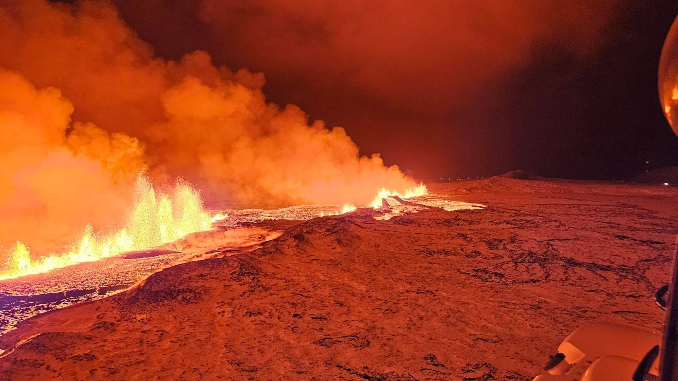
Image taken from the Coast Guard helicopter flight last night of the fissure eruption.
Just as my head hit the pillow at around 11 pm last night, my phone went doolally…
“ERUPTION.”
So I dived headlong down the stairs to wake up the PC that I’d only minutes before sent to its slumber mode. Thankfully, that’s all the travelling I had to do, unlike Isak Finnbogason, who packed his drone gear up and immediately set off to capture the unfolding drama. More of that later.
We weren’t the only ones caught on the hop. The Blue Lagoon had only just re-opened and discussions were ongoing about allowing the people of Grindavik back home in the next week.
But, thanks to the abundance of video surveillance tech in the area, this was probably about the most comprehensibly captured initial (fissure) eruption in history. Thanks to YouTube’s live feeds with timelines that can be scrolled back, most observers could watch the whole spectacle develop in “real-time.”
The first explosion in the vicinity of Sundhnukur was captured from the camera labelled as Thorbjorn. The initial phase seemingly has a phreatic component, presumably due to magmatic contact with groundwater. Ash soon fell on Thorbjorn.
A spectacular unzipping of the associated fissure followed along the old crater row… tracking a little way to the southwest towards Hagafell, but mostly to the (more benign) northeast. Pretty soon the fountains, approximately 100m tall at the highest pressure point, extended to a distance approaching 4km, with an eruptive rate of around 100 cubic metres per second.
Thankfully, most of the initial flow was easterly (though not entirely, there was some north western flow). As long as the fissure does not erupt at its south western end, in Grindavik, this is probably as good an outcome as could have been hoped for, in terms of sparing critical infrastructure. Luckily, the prevailing winds were westerly, blowing the voluminous clouds of sulphur dioxide away from large population centres.

Current map of the location and total length of the fissure from IMO.
There will be more detailed analysis later, but, in the meanwhile, some useful (and spectacular) links.
Topographic map of the area around Sundhnukur:
https://en-gb.topographic-map.com/map-gf51/Iceland/?center=63.86359%2C-22.38361&zoom=13
Start of eruption:
https://youtu.be/QcxaqCIon_Y?si=mvvIGjEOvV3LdNkT
Timelapse:
https://www.youtube.com/watch?v=ns5AgaMztOQ
Isak’s Drone Footage:
https://www.youtube.com/watch?v=I_mD-DWuwCM
More links can be found here at the ‘Ongoing Events’ page:
https://www.volcanocafe.org/ongoing-events/
Nick


First rule of Reykjanes rifting events appears to be.
When officialdom says the immeadiate danger of an eruption has passed, that’s when the eruption will happen!
The mischievous hand of Loki at play perhaps?
More likely they never should have said the immediate danger had passed when even I, a totally untrained person could see that the continued rise of svartsengi was a major cause for concern. I had been watching the seismos on and off all day because of how high the inflation had got, exceeding the level where the first run ol lava had flowed under Grindavik. So I was watching all day yesterday. Once the swarm started in the evening and once we had the first 3 mag quake I started to watch the cams and so was fortunate to be among the very first to repot the eruption on here. I am just a housewife with no formal training but I was aware something was VERY likely to happen yesterday so surely the officials should have been also.
Thanks Alice, this bugged me, too. The commentary from the experts did not seem to match the data.
Decisions like the reopening of the Blue Lagoon seemed at odds with what we knew about the ongoing reinflation. Sure, just because the magma broke out at a certain level in November was no guarantee it would do the same in December – but it would have been nice to know why the decision-makers (wrongly) believed it wouldn’t.
It’s good that the eruption did not wait any longer as we were getting to a point were people were getting (understandably) impatient, being banned from staying in their homes while absolutely nothing appears to be going on. Some were starting to defy the overnight ban and testing the limits of civil defense decisions. There was pressure building on the authorities to relax the rules before Christmas. The eruption has defused all that talk.
It would have sucked to have a late night evacuation of Grindavik last night if there had been a premature return to normal.
Ironically they may soon be able to return now that this eruption has happened in a relatively safe area for them. However that is only likely to be the case of a return if this new eruption is not long lasting. It is an extremely trying situation for the residents.
Agreed, and just to be clear my o/p was never a dig at the Icelandic authorities who are in a lose lose situation. Just that I’m particularly tickled by the mischievous, almost coquettish nature of these rifting eruptions.
The authorities could have taken what with hindsight seems the logical step of waiting a few days to see what happens when the inflation went past the previous peak value but we all know that if they had done that, then of course nothing would have happened! Residents would have been kept from their homes and businesses over the festive period, the authorities would then have got it in the neck for being over cautious at which point they then give the all clear and then as sure as eggs is eggs…… it then erupts.
These Icelandic volcano deities so clearly love to troll bureaucrats and geologists. That tremor we see on the seismometers? It’s those deities of the underworld sniggering!
Thanks, Beardy! That was some sight to see last night (UK time). If Grindavik, Blue Lagoon and Svartengi are spared, then we can enjoy this latest Reykjanes event.
Thanks for the links. There have been requests from some in other discussion groups for the videos of the startup. I can refer them here.
This has been spectacular. And surprising to many. Very pleased to see Grindavik is in the clear. For now at least. Not the Christmas they hoped for there however.
As always this is the source to come to for getting updated when something like this starts. Thank you to everyone contributing here. And especially to the authors for all shared knowledge.
On this event; always looking for patterns I can not help but noticing several incidents of weak (mostly <2) EQ-swarms over the last weeks. Magma-pulses reaching the upper feed-system? There is no central magma chamber, so some other process drives magma to beeing fed in and break the surface at some very long historical timeintervals. How? Why exactly when it does? Seeing the last little swarm over the last few days I thought this could be the trigger yesterday.
Engaged with some carpentry yesterday I was still very surprised when I saw the eruption has began. As a re-run that is. 🙂
Maybe we need to watch out for those weak EQ-swarms in this scenario? Because is not "all normal" anymore in Reykjanes. The final swarm only gave one to two hours leading up to the spectacular start, so in a future episode, having more precursors must be better. Maybe sometime in the future…?
*** "In season 32, episode 18 of Reykjanes the plot has thickened…." ***
Here in western Norway there is a forecast for SO2 from 20.12.23 @ 4 am. No danger, but might be enough to smell it tomorrow morning they say (MET). Map here;
https://www.vg.no/nyheter/utenriks/i/4oPWpG/vulkanutbruddet-paa-island?pinnedEntry=37757&utm_source=vgfront&utm_content=hovedlopet_row3_pos1&utm_medium=dre-658161647967a56fd405b800
The monitoring web page for gases in Iceland has showed good conditions in Grindavik since last night, so the cloud clearly moves SE. Our way. Not concerned. For now. Link;
https://loftgaedi.is/?zoomLevel=10&lat=63.831095061983795&lng=-22.22017875683594
Re-post. And just as I posted this, a new article was up. Just my Murphy for you…
I had noticed some seismic noise yesterday morning, hidden in the shouting from the power plant. It went away later in the morning but I was kind of on edge. When Alice began to comment in the evening and the tremor graphs showed a sudden spike, it seemed likely that something was brewing. Still came much quicker than I thought.
Happened the way I predicted, the dike from November was still there as a weak spot, so when the sill refilled for roubd 2 it repeated but with nowhere underground to go it went up instead. I personally think the numbers of 100-200 m3/s are probably around an order of magnitude too small for the start, that first fountain was huge and stayed that way even while the fissure unzipped to full length.
Even expecting it all, it still blows my mind all the same 🙂
I saw the quakes and gave a shout out but I never expected such a spectacular eruption. personally I was expecting maybe another underground lava run whilst hoping for an eruption in the right area. I was so pleased this morning that it looks most likely it will spare Grindavik, although the three larger quakes will likely have done more damage to already weakened structure in the town. But it looks like they will be spared the devastation of magma. This time at least. Who know what will happen to that town in the future. Hopefully any future eruptions, should they happen, will be further north.
The start of the eruption. Until this year I had no idea fissure eruptions started so impulsively. This is now the 4th bursting fountain caught on webcam of 2023:
https://youtu.be/QcxaqCIon_Y
I hauled my wife away from her Netflix series to watch the replay on this yesterday evening by telling her that she’ll probably never see anything like this again in her lifetime. She’s been to St. Helens, and Kilauea with me, so she’s not exactly a novice. What a boon to the volcano science community. The techs monitoring that camera must have launched out of their seats.
There was a slight delay in zooming in, as it happened. I had a vision of the operators sitting there open-mouthed, then thinking oh ****, we’d better zoom in.
A phreatic explosion, perhaps.
First the Camera had problems to adapt to the sudden light. So a part of the visible explosion is likely overestimated by the light effect.
Maybe it was illuminated steam, that rose before the eruption. There was snow before the eruption began. So it’s possible that a plume of water steam preceded the lava eruption.
A third possibility is a gas explosion if the magma was relatively gasrich.
Steam, from the fountain making a small meteorological updraft, is my guess. Same thing has been seen at Kilauea 3 times this year where lava jumps up and a big puff of steam follows.
The first bang looks like an explosion by a Gaza rocket, then the large lava fountain appears quickly and shows the character of the eruption immedietally.
Currently the eruption has concentrated on five vents. The lava flows has decreased to 25% of the first output.
https://www.ruv.is/frettir/innlent/2023-12-19-eldvirknin-thettist-vid-midbik-kvikugangsins-400131
That humongous fountain that was the first to form, is about 170 meters tall at times. I obtained the approximate height by comparing it to the 15-meter-tall cone just in front of it. It’s rare for lava fountains to reach so high during a gas-poor tholeiite fissure eruption.
It’s good that Kilauea decided not to erupt at the same time. It would be hard to follow two important eruptions at the same time. So it’s a good opportunity to pay full attention for the unique event on Iceland now.
I liked how the fissure unzipped, as caught by the camera, and then they had to adjust the pan to take in a wider field, as it was evident that the fissure line was increasing. Lots of gas pressure obviously. Some of the fountaining reminded me of the Le Piton de La Fournaise eruptions.
Thank you Nick and Gaz for the post!
I quick question I have not seen covered;
On the Sýlingafell – Vél 2 webcam from RUV on Youtube that pans the eruption left-right-left aso. is left southwards? Or is it the other way around?
Link here: https://www.youtube.com/watch?v=Bqudj0x0POA
Well. Too quick there. Had I studied the map above in the article, it should be correct that right pan is southwards and left pan is towards north. Am I correct? Just had a coffee so that might have helped.
The coffee did the trick.
Definitely correct the second time. Coffee helped me stay awake until 3:30am this morning watching the amazing show. I am fortunately retired and knew that today where I live it was going to be heavy rain. So it was worth staying up!
Thanks for the post. I’m glad I stayed watching the DAS data even when things started to go quiet a few weeks ago. I was on the phone when the swarm started yesterday evening but could see the red lines on my laptop and eventually had to share it with my family on the phone call. I confidently told them an eruption was about to happen and they now think I’m an ‘expert’! The chatter on DAS then alerted me to the eruption within a few minutes of it occurring so I watched it unzip as it happened. It really was a lifetime experience, all thanks to Volcanocafe! An early Christmas present.
And from the unrelated Nik…
‘First Alert’ report…
https://www.volcanocafe.org/the-vc-bar/comment-page-26/#comment-142406
https://www.bbc.co.uk/news/world-europe-67756413
The first 20 minutes of the eruption within 34 seconds show the fast expansion of the Curtain of Christmas Fires: https://www.ruv.is/frettir/innlent/2023-12-19-fyrstu-20-minutur-gossins-a-margfoldum-hrada-400080
GutnTog has published a map inside his new video that shows the expansion of lava around the fissures: https://www.youtube.com/watch?v=1QMRWryxy0M
The map shows, how close the eruption is to Fagradalsfjall’s plateau.
Does anyone know how high the fountaining reached? Does anyone know the exact geodetic coordinates? (lat/long/alt) for where this took off? This geolocation information still seems hard to find in the 21st century, oddly enough.
Can’t help but notice (at least according to the map) that about half of the length of the fissures follow the more ancient fissures (maybe following some kind of pre-existing fault?). Also, I would like to make a bit of a prediction of which, once it stops, it may rebuild in pressure until it erupts again or may form new fissures…
Anyways, I was quite surprised at the fact it erupted. First heard it on the news, but I thought it was clickbait for Fagradalsfjall until I actually checked and was surprised that the Rekjanes erupted.
*Reykjanes. My brain forgot about the y, so it looked like it made sense…
I tend to agree with you Zach that once the eruption stops it will be doubly important to keep a check on inflation levels at Svartsengi. What has happened twice should be taken as a major red flag in my view. The first time the residents of Grindavik were very sensible to leave before the official evacuation calls came as by then roads were begining to become damaged. What happened last night shows the importance of being aware yourself if you live in a danger area, any danger!
Regarding inflation it will be interresting to see what drop we observe initially from this outbreak. We saw a apx. 30 cm drop at Svartsengi when the sill broke into the something-gigar dike from Nov. 8. to 10. Goes to pressure release, influx, volume aso. as there are many GPS-stations that have shown the same to a various degree.
Especially since it started to re-inflate on apx. Nov. 13., it will be interresting to see new data since yesterday night going forward.
I stayed up almost as late as you Alice, up fairly early today, so I am concidering a afternoon nap. z-z-z
this webcam is now panning showing the full eruption site, there looks like 3 vents (3rd being very small ..is it to the south?)
https://www.youtube.com/watch?v=Bqudj0x0POA
I am not sure if the black area is lava flow..or is there heat in the ground to melt the snow
I am almost totally sure that all of that black area is lava flow. A truly incredible sight so many thanks for letting us know that cam was panning at this time. All along that whole area was lit up by fire last night, at least until 3:30am until I stopped watching anyway.
Greg, thanks for the link. This camera captures what it would be like to stand on a hillside, in a snow storm, watching an eruption from a fairly safe distance. Next best thing to being there.
The eruptions has unfortunately decided to happen during a snowstorm. It’s difficult to see. This RUV cam shows a part of the lava fissure (are there more lava fissures apart from this?): https://www.youtube.com/watch?v=VIs83vmfZCk
The lava appears to me a bit more sluggish than during the night. Is this an optical illusion or has the magma changed somehow a bit (f.e. cooler, aged magma from the sill)? The lava fountains also look more orange than yellow, as if they’re a bit cooler than before.
The view of one cam was falsified a bit, so that I got the illisuion of a snowstorm. It has cleared now.
I think there is a lot of actual bands of snow passing through. I wish I was in Iceland now. All we have in South UK is intolerable rain and gloom with only a few sunny days all month. So very depressing.
Phil,
maybe you are comparing the early color (during the night) to the current one? I do not think that the camera will reproduce colors the same way during the night and during the day (or with any change of the environment lighting conditions for that matter). With that, I cannot really see an obvious difference up to now.
For a direct comparison you will need to compare two times without camera saturation, and also with almost identical lighting – and even in the night that is not always the same, as the cameras will adapt to changes in brightness in ways that will typically not leave the color totally unaffected.
That’s true. Here is the video from the night: https://www.youtube.com/watch?v=QcxaqCIon_Y&t=284s
And the present live eruption (view from Sylingafjell): https://www.youtube.com/watch?v=VIs83vmfZCk
Apart from the question of the color, the lava fountains don’t look as straight and sharp as during the night. They now look as if they’ve lost power or something.
I think that they really have lost power although the one vernt left further to the north is still doing some good fountaining. Or was the last time I looked 30 minutes ago.
It will likely fairly soon shut down to one vent as past fissures have in the last years.
I think those live cams simplify colors as the first step in the compression that allows such brilliant images to be sent with the least possible bandwidth. In awaiting the eruption these past few weeks, I made a hobby of zooming in on decorative lighting in Grindavik. One red light on the West side of town was (and still is, I think) a gorgeous bright red. Similarly, a blue light on the Eastern side of town was an intoxicating deep blue. I also found what was probably accentuated purple light. Green and yellow remained comparatively dull. Long way of saying that the camera hardware (or software or both) simplify and accentuate most colors. Not inaccurately, as much as possible I think, but probably not true color. If you could see all my screenshots of Grindavik you would think I went a bit crazy. I suppose I did.
Here is another interesting view from “Husafjial”..is that directly south of the fissures (Hagafell????) the spelling is slightly different than the map posted above. If it is the same, then, I am guessing that high point in the left of the lava flow is “Hagafell”..and off to the left is Grindavik (out of view)
https://www.youtube.com/watch?v=8bfcTBLvPiM
I could be completely wrong as I am not sure of the spellings
Husafell is the mountain east of Grindavik and to the north of the Southern Coast Road: https://www.volcanocafe.org/ongoing-events/
If lava “seeks” to do an ocean entry, than this would be the theoretical way. But for now this eruption is on the wrong place to send lava so far. I have the feeling that the current eruption decides to floood the whole plain area between Fagradalsfjall’s plateau and Sylingafell. If you visit Fagradalsfjall’s plateau, you would on the west side see the new lava field, and on the east side the 2021 Geldinga lava field.
Husafell is app. 150m high. So it can be called a “mountain” and not a hill, if a mountain must be at least 100m high above the surrounding landscape or sea. But there are thousand ways to distinguish between hill and moutain.
The Icelandic word for “hill” is “Hóll”, but how often do they use this in Iceland? The most typical Icelandic landform of hills are moraines created by glaciers.
English ‘hill’ comes from Proto-Germanic word ‘hulliz’, see https://en.wiktionary.org/wiki/Reconstruction:Proto-Germanic/hulliz. Icelandic ‘hóll’ comes from Proto-Germanic ‘huhalaz’, see https://en.wiktionary.org/wiki/h%C3%B3ll.
The Skandinavians both use the words “Haugen” and “Åsen”. I wonder why Iceland lost this? Maybe the wrong hills? Or did Skandinavia lose the Icelandic/Norse “Hóll”?
The German “Hügel” has likely the same root as the Norwegian “Haugen” (meaning a “high” location).
In the borders of Scotland along the River Tweed the word Haugh is used a lot, Walkershaugh, Whitehaugh and so on. I read that it was old Scots for a flood plain which makes sense as all areas I know are flat low lying areas beside the river.
Also in Northern England and more southern areas of Scotland the word Fell is used for a smaller land rise or small mountain but aways called mountain for larger mountains. Interestingly Fell or Fjall was from the old Norse whose language infilrated more northern areas of the UK. In Scotland most mountain peaks are called Bens as in Ben Lomand or Ben Nevis. This latter word was derived from Gaelic beinn, from beann. This is why the English language is so rich in variations of names and words.
A small swarm of small quakes closer to Grindavik for 15:01 to 15:47.
Not sure of what significance, if any. Perhaps someone else may have an idea?
OOPs that should have gone below.
@Volcanophil.
The Scandinavian languages have been heavily influenced by other languages over a number of centuries. For example, modern Norwegian has a heavy Danish influence (although pronunciation is quite different). YOu often get language pairs and Norwgian and Icelandic are considered one pair, just like English is paried with Fris (Frisian). Just like Old English was very similar to Fris, Old Norwegian was similar to Icelandic. English and Norwegian have chaned a lot due to invaders and other continental influences. Iceland was more isolated, so had less influences and the language has changed less as a result. Faroese is also very similar and is little changed for the same reason, despite both being part of Denmark (Iceland gained indpendence in World War 2).
There are still some similar words, so that I can work out some meanings from my now rusty Norwegian, but many are changed quite considerably.
The plain area here is actually a combination of two previous hrauns, one 2000 years old and the other perhaps two or three times older. Neither reached the coast, I think.
It’s interesting to watch how the lava flows run on this shallow, even territory. It’s nearly like a volcanic eruption in Netherland. Usually eruptions happen on mountains, and steep slopes allow fast lava flows.
The present eruption has the site on a hraun plain – as you mention – as there are many hrauns around. This looks like a typical eruption type for the western Reykjanes peninsula. There are broad, even fields, which allow lava to stay relatively well close to the source/fissure. They don’t have to hurry somewhere. We get a line of fissures (f.e. North-south), and vertically from them (east-west) is the direction of slow, but liquid lava flows on a broad front line. If I look on the lava layers in the Volcano Catalogue, the distance, lava usually travels in the Svartsengi area, is around 2km. In the current case the old hills of Sylingarfell and others prevent the full progression like this.
Visitors of the eruption can be seen on the RUV cam: https://www.youtube.com/watch?v=VIs83vmfZCk
Glad it’s not just me who saw that – there’s always someone who doesn’t understand what a ‘closed’ area means and ignores all the official advice to stay well away…
I saw three people with headlamps returning toward the camera at Sýlingafell like they had already been to the fissure and back. This was only 4 hours after the eruption began. My first thought was idiots. My second thought was volcano techs dropped off on Sýlingafell by a helicopter so they could grab a lava sample. I’ve no indication which categorisation would be accurate. There was one clip of a chopper dropping people off, but I don’t know whether that was on borbjorn or Sýlingafell.
I wondered if they had been dropped of to retrieve scientific instruments from the area. I was fairly sure that I saw at least one person dropped of by helicopter at one point, However I think your idea of lava samples it likely the most correct as that is what happened in previous eruptions. They wanted those early magma samples.
The volcano paparazzi will have their way and their day, tho official Iceland beg ‘stay away’. Pity there’s no vaccine for stupidity.
There is a rather extreme cure though, often fatal.
At least some of those were scientists taking samples. Also there was some talk of escorting media to the fissure today.
Mbl.is has provided a guide for the pronounciation of the different names….
https://icelandmonitor.mbl.is/news/news/2023/12/19/newest_volcanic_tongue_twister/
Thanks for that Lavendel. I love to hear and practice the correct pronunciations. I was very close on Sundhnukagigar but way out on others.
I think I should have been born a parrot. Writing it phonetically helps but listening is the best way to get the correct inflections in the voice.
Thanks Lavendel
“An eruption has started near Sundhnúkagígar on the Reykjanes peninsula”
Well, the first fountain literally blew out through one of the largest Sundhnúkagígar/Sundhnukur cones.
Mbl.is has provided a guide for the pronounciation of the different names….
https://icelandmonitor.mbl.is/news/news/2023/12/19/newest_volcanic_tongue_twister/
The gathering gloom of an Icelandic night is really showing up the areas of active lava at the moment. This cam indicates the extent of the hot lava,
Fortunately the lava to the south looks very inactive now. So Grindavik has hopefully missed the worst this time round.
Geochemistry and Petrology Group @ Uni. Iceland
@rockhardIES
Preliminary glass data from the #2023svartsengi eruption! The ongoing eruption north of Hagafell, although more evolved, has a similar composition to the late erupted lavas from Fagradalsfjall. Glass MgO and K2O/TiO2 are of 6.0 wt% and 0.24, respectively.
https://twitter.com/rockhardIES/status/1737132762132365649
https://pbs.twimg.com/media/GBuIcqxXYAAlP5M?format=jpg&name=4096×4096
Thank you for this!
I’d been wondering if there was a shared deep source. Looks like that might be the case?
A small swarm of small quakes closer to Grindavik for 15:01 to 15:47.
Not sure of what significance, if any. Perhaps someone else may have an idea?
https://www.youtube.com/watch?v=8bfcTBLvPiM
So pleased this Husafell cam is back up and running. If this eruption continues for any time it will be useful for monitoring any lava flow that may decide to head south. Not looking too likely that will happen at the moment of course.
Only 3 small vents remaining now.
And one big one, at least as cameras go…
Zach, I would expect now that by tomorrow that big one to the north will be the only one left.
It is nearest to source and is definitely weakening its siblings.
I also presume is where the eruption first started, I think.
I cant be sure, but it was certainly closer to the area of the initial eruption. I am unsure as to the initial eruption area because it was initially clearly quite a distance away when the eruption started. Then of course the cams zoomed in and in my mind everything regarding distance was muddled.
I have though noticed that in previous rift eruptions, then the initial eruption area does not seem to be important as to which area continues the eruption. it appears that both ends of the rift seem to close down first and the middle area appears to be more robust as to sustaining eruptive power. I am probably explaining this very badly because as I always say, I have only what I have seen happen in previous rift eruptions in Iceland to go on. I just think the strongest area of eruption will be the one that will parasitise the lava from the weaker areas. And currently the largest eruption is to the North which is very good news for Grindavik.
From the original camera, it does appear to be the original point where lava first surfaced.
https://www.youtube.com/live/BerZJunvSik?si=PAa2tVU-VkJnicnO
Thanks Jeffrey. My navigation skills have always been poor. I was once told I couldn’t find my way out of a paper bag.
🙂 🙂
Can anyone supply the geo-coordinates for the big vent in the north, so this can be looked at on the Iceland terrain map?
Hmm, the sill under Svartsengi fills, then empties, fills, then empties – lava, rinse, repeat?
I am hoping not repeat. But I do feel the repeat is the most likely scenario. Once this current eruption drains the chamber then I do think another refill is on the cards.
The biggest problem then is where does it go next time? Same or different?
The Fagradalsfjall eruptions moved north. If this is also the case for Svartsengi, then this would be good news.
Given that the Reykjanes system has had nearly as many intrusions as Fagradals, although this is the first one that actually erupted, odds are high it may repeat not too long in the future.
Well, maybe not? There are new GPS data entries today (from after the start of the eruption I assume) that shows continued inflation at Svartsengi (SENG), little to no vertical movement at Sundhjukagigar (SUND) + Thorbjørn (THOB) – still within the uplift trend – and some deflation (5 mm.) south of Grindavik at Gerdavallakriki (GEVK). Hm. These data-points are showing green now (for the day). Others are not yet updated as of now. I find this a little confusing as the infill from the sill to the dike caused a 20-30 cm drop within two days in this area.
I know single data points can be somewhat misleading, but it surprised me that a vigorous eruption like it started as last night seemingly has not made a single dent in the upwards inflationtrend around the eruptionsite.
Am I reading this the wrong way? Are there GPS data available with a more frequent update rate? And again, could we be up for some major surprises here if those data point continue to show the same?
Please correct me if I am reading this wrong. Post nap – coffee at hand – should be good to go now. 🙂
Never mind. The specialist at visir would know right? Thanks to Kalel M. I saw the update now.
The GPS datapoints I found at vafri.is are updated the following day then I presume. More coffee!
Rinse and repeat it is.
The sill might act like a central volcano.
new hazard map. Deflation so far 7cm out of 35cm previous inflation, future uncertain. Read more at vedur.is.
Interesting. So the elevation of Svartsengi is acting as a sort of bourdon tube in a pressure gauge. Once it stabilizes with fairly constant outflow to the East, they’ll have some idea as to the volume of new lava entering the system from down deep. Takes me awhile to catch on.
New lava flow model:
https://twitter.com/RUVfrettir/status/1737183003531419851
Looks like it will hit route 43 soon if it hasn’t already.
After translating the Icelandic on that post it appears this is only a predicted lava flow.
Google translate.
New lava flow model until the evening of Dec 25:
Assuming that the flow was 300 m³ per second at the beginning of the eruption and then the flow gradually decreases until it reaches a balance of 30 m³ per second from part of the fissure.
Lava could reach Grindavíkurvegi on Christmas Eve.
So an awful lot depends on the lava flow rate.
we are still 6 days away from that model and the lava flow could decline just as dramatically as the lava stopped flowing under Grindavik. Unless I am missing something here.
Ah I assumed that was what had actually occured, so not quite that bad yet then.
I do wonder though if the inflation will resume aftewards and repeat the same process or if that wil be it and back to the usuall Fagra episodes.
I think both is possible, as the volcanoes are not connected with each other (although the distance is very small). They both share the same deep mantle source, but their pockets and sills are individual and can fill independently from each other. Maybe more magma from the deep source is being diverted to Svartsengi right now, but it is too early to call Fagradallsfjall off.
Looking back into the history of Rejkjanes, the activity jumped from back and forth between several volcanic systems. This is very typical for a rifting episode. The magma is only waiting for an area of crustal weakness and will happily intrude at every occasion it gets.
At the moment, activity is focused on Svartsengi and Fagradallsfjall, but I am pretty sure that it is only a matter of time until we see activity at Krysuvik and Rejkjanes, too.
Also on the IMO website it says,
The power of the eruption has decreased with time as well as the seismicity and deformation. On the latest surveilance photos the activity is now constrained to 3 craters, but was earlier five, SE of Stóra-Skógafell.
Certainly the flow from the 3 smaller craters had definitely decreased.
I am always wary of predicted models.
Sorry if I have burst anyones bubble but there is a high possibility there could be just one crater tomorrow and no given that this will even continue as long as the 25th. I hope it does but have reservations.
Basically as I see it, it all depends on the supply of magma, which currently has slowed but the northern crater appears to be going strong so anyones guess I suppose.
There’s no obvious reason it can’t enter a reasonably steady state at this point. If outflow matches supply (from wherever) this could go on for quite awhile. I think Svartsengi’s elevation will fall at a decreasing rate. If it can stabilize above where it fell to on November 10th, the cycle of inflation/deflation will more or less flatline into a depletion slope. Of course that’s envisioning a system like an oil & gas reservoir, which this is not. I still think this single outlet could easily continue into January or February. As said above by people more knowledgeable than me, we just have to see what Svartsengi does.
I have to believe that the potential volume of magma available at a major plate boundary is pretty vast.
Well having been away from the computer for a couple of hours I had expected to see the smaller crater down to a far smaller level of eruption by now. Instead it is clearly alive and well. So yes, clearly it looks to continue on for a goodish while yet. As for the larger eruption that is going great guns. It certainly looks like there is no great draining of the sill at the moment. Perhaps that advanced rate of inflation is keeping things simmering along nicely.
So I am happy to say I was wrong in being too negative and it looks like being a longer eruption than I had anticipated.
There’s every bit of the same chance I’m wrong about it flowing as a steady state for awhile. Especially since I said it. I learned in 2021 that geophysical dynamics don’t care what I think and aren’t listening anyway. There’s a note below that the larger volcanic feature has fallen way off. Doesn’t seem to be the case now but it sure could have had trouble clearing its throat for a bit. Gave me a fright.
My primary um… guess (lets be real) was that the previous inflation/deflation cycles were because of the clearing of obstacles (analogous to the rupture discs we humans use on pressured vessels) first at depth on November 10th and then toward the surface about 20 hours ago — so no more obstructions, no more inflation/deflation cycle. A dead volcano (which this one will be sooner or later) is a steady state just as much as a smoothly erupting one, so it’s a pretty safe guess… which can still be perfectly wrong.
Interesting article on RUV now about the lava’s chemical composition.
“The first results of rock mineral measurements on lava samples strongly indicate that this prey that is coming up at Sundhnúksgíga is very similar to the prey we saw in Fagradalsfjall. First of all, in the 2021 eruption, when that eruption started, and then in the 2022 and 2023 eruptions,” says Sæmundur.
When asked, Sæmundur says that it is easy to imagine that the lava all comes from the same pot.
“Yes, it is quite possible to imagine that there is a large reservoir, possibly, that is emitting material. And this time the material managed to reach the surface,” says Sæmundur.
—
Looks like further evidence that the peninsula is one big interconnected system rather than 6 different ones (although perhaps Hengill is a bit more of its own person!).
It was said after the eruption in July that the lava erupting was closer in composition to the lava erupted at Vatnajokull, than to the lava erupted in earlier eruptions on Reykjanes.
This was a point of debate, because Fagradalsfjall has bot taken part in the earlier Holocene cycles, so was its magma composition because it is going out on its own or is it more fundamental? We have the answer now, the Reykjanes volcanoes are all waking up, abd the atypical magma seems to be common to at least two of the systems.
Thing is, in the 21st century and a few years before, intrusions have happened repeatedly out on the Reykjanes ridge, at Eldey, Reykjanes, Svartsengi, Fagradalsfjall, Krysuvik and Hromundartindur. Intrusions have also possibly happened at Brennisteinsfjoll, Hengill, and next to Skjaldbreidur. Basically there have been intrusions along nearly every bit of the plate boundary from far offshore of Iceland going up to almost Langjokull. There has also been an eruption of Hekla and several powerful earthquakes along the SISZ, which is the other end of the plate boundary that goes through Reykjanes… Literally all of this since the mid 90s…
The thing is, if the pseudo-plume basalt of Fagradalsfjall is also erupting at Svartsengi then it is probably the source of all of these intrusions. The number of volcanic events at Reykjanes that has happened in recent years is far more than I have seen ever referenced to the middle ages. We are at 4 eruptions in 3 years at 2 dufferent systems, in the middle ages it seems like multiple years go between eruptions, even decades at times during which a volcano gives way to another. Either this is wrong or the present activity is playing by a completely different rulebook.
Svartsengi is much more close to Fagradalsfjall than f.e. the western end of Reykjanes system (F.e. Gunnuhver). Maybe in fact Svartsengi is related to Fagradalsfjall like Krysuvik to Fagradalsfjall. They’re very close to each other. There might be some positive correlation the way that Fires on One system supports the Fires on the neighbouring system. Like Grimsvötn 2011 and Bardarbunga 2014.
There seems to be a tentative seismic link between the three.
NASA joined the fun by providing satellite images in the infrared band showing the surface temperatures before and after the eruption started:
The accompanying article can be found here:
https://earthobservatory.nasa.gov/images/152227/iceland-erupts
That’s cool. No, hot. No, cool. Cool and hot.
Does anyone have an idea of the thickness of the lava layer?
Too early to tell for certain but it looks like Svartsengi elevation might stabilize where it was before the initial inflation back in September and October.
Thank you Beardy Gaz! Wow! awesomely beautiful but my thoughts are with the people of Grindavik. Not a very happy Christmas but at least they are safe even if they will likly loose their homes.
On the RUV Sylingarfell cam pointed at the northern vent, the lava fountaining has suddenly dropped off dramatically, but there’s a small vent on the top of the cone where there appears to be a lot of gas escaping, at least some of which is burning with an orange flame. Could it be hydrogen gas?
https://www.youtube.com/live/VIs83vmfZCk?si=baxJTgl3dOQT6N_l
Okay, I commented this on the last article, but I still can’t find that paper that described the rift cycle for the EVZ. I recall it being used to suggest that there’s about a 75% chance of a major eastern fires episode within the next several decades or something, but.
LEAKED! 2024 Eruption Calendar
January – United States – Kilauea
June/July – Iceland – Fagradalsfjall round 4
September – Indonesia – Something Agung VEI 4
November – United States – District of Columbia
November – Russia – Kamchatka VEI 3
December – United States – Kilauea
No word though on whether there will be ongoing or repeated episodes at Svartsengi, versus it going back to sleep for a while.
Probably add a few more for Kilauea and Svartsengi. If this eruption is anything to go by then we might get monthly repeats until the supply to the sill slows down… and Kilauea is Kilauea 🙂
Do hope Agung doesnt do a VEI 4 though, like I said last article the volume is not high but they are intense, local apocalypse…
You forgot the Ioto VEI 7. Just joking (I hope).
https://en.vedur.is/about-imo/news/a-seismic-swarm-started-north-of-grindavik-last-night
Maybe a little outdated in information, it has a lava flow map.
I’m confused about a couple of things;
1. the name of this geologic feature:Sundhnúksgíga? Sundhnúksgígar? Svartsengi? Is naming still to come?
2. Is it a volcano? In my mind, it’s a part of the MAR that has erupted magma (now lava). All along the MAR there are magma leaks and they’re not called volcanoes. Doesn’t a volcano have to have a magma chamber?
I thought the name was Sundhnukur, which I first came across on a digital geologic map that I no longer know how to find. But everyone seems to be calling in different more complicated manners. As for a volcano I think it does count as a volcanic system (Sundhnukur), which is a polygenetic fissure system that had some eruptions 2000 years ago and probably earlier too, but which is part of a larger volcanic field (Reykjanes, the MAR?).
Hopefully I can clear this mess up:
Sund – hnukur : Bay – peak
Sund – hnuka – gígar: Bay – peak – craters
Sund – hnuka – gíga – röð: Bay – peak – crater – row
Much appreciated!
The vent the YAQ cam’s focused on is merrily building a nice little cone for itself.
All of the tremor graphs in the area have fallen off a cliff. It looks like this eruption cycle is almost over; but, hopefully, it might repeat.
Okay, another dumb question. Has this eruption run out of gas? It is obvious from the initial eruption startup that intense gas pressure existed, throwing lava some 100 meters into the air, but right now 3:31 am Dec 20th 2023 Iceland time, we have only 3 weak vents and those growing weaker by the moment.
I would love to hear a volcano gas expert explain what is going on here?
Where do you see three vents? I only see a single vent with more than one opening.
There is only one Strombolian vent with rythmical lava fountains/bombs, a second major vent with a gas/steam plume and several spots inside the lava field / crater row that release minor gas/steam pulses. It’s uncertain whether these spots are gas eruptive “vents” or holes inside the lava field.
I quote from the IMO –> “. On the latest surveillance photos the activity is now constrained to 2 craters, but was earlier three, SE of Stóra-Skógafell.” and I took their word for it at the time.
I believe in you little volcano. People watched you store motive energy into rock structures for 37 days, probably at a rate not too dissimilar from that you’re erupting right now, yet they wonder why you didn’t keep spraying molten lava at 300 cubic meters every second for more than a few hours.
I know you’re going to keep doing your best. Thanks for a very impressive show. Hope you’re still there come Summer when its not so dark. Or cold.
As I see it, it over zipped, now it has its house in order and see’s the sense of having just a number of vents , it was a great show the opening eruption- talking about seeking attention! Now just stay away from people,homes, power stations,large blue pools and roads and fishing harbour !
That’s alot to ask of our volcano- the future is uncertain , but so far so good! Ps it still has life in it-
The vent has obviously reduced to (effusive) Strombolian activity: https://www.youtube.com/watch?v=VIs83vmfZCk
Research for the magma chamber of Svartsengi: https://www.ruv.is/frettir/innlent/2023-12-20-visbendingar-um-kvikuholf-undir-svartsengi-400328
Halldór Geirsson has found three evidences for a magma chamber at 5-7 km depth:
1. Geochemistry indicates that magma stopped the upward move once during historical and prehistorical activity
2. Earthquake waves that reduce their speed, if they cross a magma chamber. They did so at Svartsengi
3. The behaviour of recent intrusions 2020-2023 which showed that magma rose from deeper sources into depths 5-7 km below the surface.
Is the magma chamber an important difference to Fagradalsfjall? There has until now no intrusion accumulated at a comparable shallow depth as a magma chamber. Each intrusion at Fagradalsfjall 2021-2023 reached successfully the surface and made an eruption. They were fed directly from the deep sources.
Well, this was unexpectedly minimal.
As the eruption is dwindling down it is time to start taking stock.
It turned out that this was only a minor eruption at Reykjanes, quite a bit smaller than the Fagradalsfjäll eruptions, it was even smaller than Fagra III.
Obviously there’s quite a bit of magma remaining in the reservoir, but it boils down to pressure, and there is just not enough of that remaining to continue driving the eruption forward.
My guesstimate is that the eruption will be over within the next 72 hours, unless of course a new fissure will open.
I do not think that is likely due to the low pressure, at least in the short run.
If/when the pressure has built back up it is likely that we will get a new eruption.
My guesstimate for this is anything from 3 to 12 months.
This MBL cam shows that there remains one active gas/steam vent and one Strombolian vent: https://www.youtube.com/watch?v=P1e_MWJ1nQc
It is indeed surprising how short the eruptions is going to be. It is comparable to the many short eruptions Kilauea did during the 1970s and 1980-1982.
The output rate per second during the first hours was clearly larger than any of the recent Fagradalsfjall eruptions. Fagradalsfjall’s fissures were no such “Curtain of Fires” that Svartsengi did. But Fagradalsfjall’s eruptions had longer life than the first Svartsengi one. The historical lava layers and crater/fissures show that Svartsengi can do a series of many short eruptions like that we’ve had.
It is kind of cool watching the main cone Strombolize, but then the flames shoot out from 4 areas to the right.
The intrusion on 10/11/23 opened up the rift, after 5 weeks the sills refilled again and almost exactly at the same point it ruptured in the same place. I havent seen the graph yet and it might not be updated anyway but the second round of eruption should be predictable to within days based on that. Svartsengi doesnt have a permanent magma chamber but it seems to create one and behave like a central volcano when it is active as now. Maybe that is due to Þorbjorn being an atypically tall hill for the area and changing the stress field underground.
The last intrusion was fully recovered in 5 weeks, for a volume of around 80 million m3. And that first intrusion is usually bigger than the later ones, so if anything the interval will probably be less. This lava might be barely cooled before round 2.
The Catalogue of Icelandic Volcanoes writes about Reykjanes system: “Holocene eruptions are assumed to originate from shallow-level transient magma chambers, at around 3-4 km depth.”
There is a high densitiy of old dykes at 2km depth that indicate that in several cases there occured temporary magma chambers like the present one.
We just witnessed the formation of the transient magma chamber and the first eruption during this formation period. We shall see, how it works, when it has established its position. “It is not known how long individual eruptions within each Fire episode may last.” We have to find out, how long the future individual eruptions will be.
SENG latest 4 hr
I know we need more data points and could be fooled by error in gps but it does almost look like it is erupting and back to inflating at the same time.
So, based on the current GPS status, combined with Chad’s reasoning above, it will reach breaking point again in three weeks from now. Write down January 10 for the premiere of episode II 😎
The new Krafla Fires…
SENG definitely is being shoved West showing an interesting creep Northwards, but the elevation is intriguing. It rose up to the dike injection point, dropped, rose again, surprised the Nov point, then boom! eruption again, to start rising again, I believe.
OH dear. I just came on here. I leave you all overnight and someone forgot to stoke the fire.
https://www.youtube.com/watch?v=P1e_MWJ1nQc
Sadly, and I do mean sadly as I love watching volcanoes, what I said last night has proven true. The small vent has gone from five to just an occassional blip and even the large one appears to be struggling. Once I knew Grindavik was safe I was hoping for more. However, seeing the amount of lava spread out in the initial stage of the eruption and remembering how thankfully short lived the first lava flow was under Grindavik, then I came to the conclusion that the amount of lava under Svartsengi may not be able to support a long lived eruption.
So sad to see my forecast looking to be true.
On an even more sober note. What is the chance of the chamber under Svartseng refilling and venting several times? Hopefully not as that would cause serious disruption for many months or even longer. However thinking of other long lived rift eruptions if has clearly happened before.
And on a positive note, perhaps now the pot has boiled over with hopefully no further damage to Grindavik, perhaps they will allow residents back, even if only for a month or so.
Grindavik may hope that the Fagradalsfjall trend towards the north of eruptions also happens at Svartsengi. Holocene eruption fissures happened from the current fissure towards the north, even inside Fagradalsfjall’s shield lava field. Maybe we’ll get the situation that lava flows from both systems come close to each other. Fagradalsfjall’s lava flows may once turn towards NW, while Svartsengi may open a fissure inside the Thrainsskjöldurhraun.
Random question from someone who knows little about geology:
Which of the ‘hotspots’ dotted around the planet are currently the most productive in terms of magma? The ones I can think of are Iceland, the Canaries, Hawaii, Reunion and Yellowstone. Sorry for asking what is no doubt a very simplistic question.
Hawaii its not even close. Galapagos is about half as powerful as Hawaii, and the others are all about half as powerful again or less. Iceland cheats by being combined with a ridge, the plume alone would not be so strong.
Hawaii is a blowtorch from the core/mantle boundary. The hottest lava erupted on our planet since the breakup of Pangea was erupted by a Hawaiian volcano 16 million years ago, 1700 C… Kilauea today is getting up on 1300 C in its upper magma chamber based on lava lake temperatures and crystals in 2018. If Hawaii was under thicker crust it would almost certainly be a LIP province with that kind of heat flow.
Defenetivly the Hawaiian with souch large volcanoes formed in souch fast time, and souch hot cheimstry as Chad says. Hawaii is probably similar to the archean plumes, and may even have komatites down in the astenosphere, that evolves into thoelitic basalts. But Hector have alternative theories of plumes, and Carl woud dissagree
But as Chad and Hector.. I too say Hawaii is the strongest induvidual magma source, many induvidual hawaiian volcanoes are freaking as big as the entire CRFB sequence! thats quite unique volumes for induvidual volcanoes, and explains my fascination too for hawaiian volcanism
Nothing else either is as beautyful as these giant shields, I just loves Mauna Loas immense shape that takes hours, hours to drive around on highway speed, and Kilauea is so large you cannot even see it from the ground, well Mauna Loa the same in most cases, the size is fascination for me, was a very impressive sight everytime in Big Island, with Mauna Loa basicaly swalllowing up horizon, and you coud see its distant foot 100 km away sitting on a rock sea arch, really giant volcanoes, that made Etna feel like a dwarf really
Its so gigantic its almost ubelivable, to drive around Mauna Loa and Kilauea, defentivly an experience to do
From where ML’s 1859 flow crosses HI-19 at Waikoloa, you *can’t even see* ML’s summit!
Possible in a small hill and clear weather and possible from some ways at the Kona airport, but yes the enormous mass that is Mauna Loa is mostly hidden. Its incredible how how hot waikoloa gets even in winter, over 30 degrees c at lunchtine is common so its warmer than most tropical rainforest areas even, I have been many decembers in the kohala desert with searing 33 c temperatures. Living in Big Island is relaxing and pleasant but only bearable upslope in cooler areas
Interesting that you say ‘hot’. I stayed at the Four Seasons Hualalai in October of 2023, after three days at Volcano House and found both quite comfortable. 30-33C is quite tolerable in my experiences world wide, particularly at low humidity.
I agree with your comments about temperature. I suppose it all depends upon to what you are accustomed. Having lived in the Pacific Northwest for many years I find 18 to 20C most comfortable for cycling and up to 22C if walking. We chose to stay in Volcano for most of our short visit in February 2018 because it was the coolest place we could find.
Hawaii is Earths Olympic Mons concerning volcanism. It is The “Planetary Hotspot”, if we want to use this expression. Just look on the Earth without water, then you see immediately the enormous size of Hawaii Mountain and Hotspot.
The 1. Class of ordinary Hotspots are Reunion, Iceland and Galapagos. They are often, reliable active.
The 2. Class of medium active Hotspots includes the Canaries and Azores. If you are lucky, you get an eruption there during your lifetime, but it’s not certain.
The 3. Class of weak Hotspots include f.e. St. Helena, Tristan and Eifel. Usually dormant. Activity is the excemption, sometimes after thousands of years.
If we apply the Hawaiian lifecycle on the other Hotspots, the 2. Class only reaches towards the “postshield” activity like Hualalai or Mauna Kea. The 3. Class represents the rejuvenated stage (f.e. Honolulu).
Iceland and Hawaii top the list of mantle-fixed volcanic provinces at about 0.1 km3 per year in the long term. Hawaii is more straightforward to calculate, while the number for Iceland is the amount of rock higher than a typical mid-ocean ridge for the entire Reykjanes Ridge plus Iceland and Tjornes. Galapagos is about 0.05 km3 per year taking into account both the islands and the slightly overproductive MOR next to it. Reunion is 0.02 km3/year. Others are below Reunion. Comores, Cape Verde, Canary, Amsterdam-St Paul, and Azores as honorable mentions. Samoa, Tahiti, and Marquesas were really powerful only about a million years ago, comparable to Reunion, and a few million years ago Samoa may have been nearly as powerful as Hawaii, but the Polynesia has shut off somewhat. Yellowstone is powerful but the volume doesn’t make it to the surface (not buoyant in continental crust) so it’s not really productive in terms of effusion.
Iceland is incredibley powerful as a whole region its gigantic simply, the largest frequently active lava plateau on the planet. Its a few million km3 the whole area, Hawaii woud be the same on a slower moving plate.
But Iceland is not a single gigantic volcano like the mega – shield edifices of Hawaii, its a collection of weaker systems. Still ”weak” is a definition, Bardarbunga and Grimsvötn are large too, but kind of robbed by their rifting.
Iceland is a giant volcano continent, which has accumulated all the volcanism over millions of years on the same big island. Imagine the Hawaii Hotspot without plate movement. It would have a large island like Iceland and possibly the highes mountain in the world. Imagine a Mauna Loa with Mt. Everest height.
https://www.youtube.com/watch?v=2ZJs4gjHda0
Beautyful and with snow too, well it coud be Io if the snow was made of yellow sulfur and if the atmosphere was removed. Looking at the lava its the same textures as meradalir and the hruttur lavas, fluid but not willing to make truely smooth surfaces close to the vents, so its probably crystal rich, it coud be the gases too, the new Iceland lavas is fluid, but not like the summer 2021 stuff that was superhot iron rich thoeltic stuff
No eruption visible on cam now…
Snow again. I am jealous.
latest map.
Wasn’t there a lava flow towards the Grindavik – Vogar road?
No Phil there was a predicted one which would likely have happened if the volcano hadn’t lost strength.
Thank you, got the geolocation information I was searching for.
Perfect eruption, visually spectacular, no damage, good build-up, and most importantly for me, very quick!
Esthetics not withstanding, we pray that Surtur spare the town, the surrounding infrastructure, and the Blue Lagoon.
That didn’t last long! Spectacular, exciting, and stopping before any damage is done. Was this the perfect eruption?
Well perfect until it does it again in 5 weeks. Then 5 weeks after that. Maybe even sooner if intrusions get smaller and fail to fully deflate the sill. As long as the deep supply is still alive it can keep doing this.
You 1005 have my backing on this supposition. Unless something changes I can forsee a future of regular eruptions from the Svartsengi source. I sincerely hope something does change, and changes sooner rather than later.
100% nor 1005. DOH!!
Maybe Surtur took a hint from the last Kīlauea eruption? 🙂
Hello guys!
I don’t know if it has ended (I’m nonprofessional), but this cam has something on it:
Thanks