Looking back to when Fagradalsfjall eruption started, I wrote a post about the Reykjanes Fires, where I speculated about how the eruption could end up being like. I mentioned two main possibilities. One was that it would turn out similar to the eruptions of the Brennisteinsfjöll volcanic system that took place 1000 years ago. The other was that the eruption would become a shield volcano, a dyngja. It has become increasingly clear to me that the current eruption is walking down the second path. A shield volcano in the making.
To watch the birth and evolution of a new volcano is a rare opportunity. I find it quite interesting. This is why even after writing three posts about the Fagradalsfjall eruption I still have so many questions and so much to say about them. This post will go about shield volcanoes and their varied types of activity, these I have divided into three “stages”, a simplification of the complex evolution of these volcanoes. I should say that by shield volcano I will be referring to those that are formed in one unique eruption, the term monogenetic is used in such cases. The contrary would be polygenetic, which are the volcanoes that go through many eruptions and long dormancies, so that they remain active for thousands or millions of years.
Why is Fagradalsfajall so different?
The first sign that the eruption was special was the deep origin and primitiveness of its magma composition. Scientists who have studied the lava erupted from the volcano have reported its remarkable characteristics. It rises up from a depth of 15-20 km in the mantle. Several markers of how primitive the magma was turned out to be remarkably high.
Additionally this eruption has broken a very long volcanic dormancy of ~800 years in the entire area of the Rekyjanes Peninsula and the Western Volcanic Zone of Iceland, since the Reyjanes Fires and the massive Hallmundarhraun eruptions took place. This could have consequences regarding the amount of magma available in the area.
The most striking aspect of the eruption is Ragnar, the name that some have been using for the currently active vent. Its size is enormous, over 100 meters tall. Typical eruptions of the Rekjanes Peninsula make cones that are 10-20 meters high, some may perhaps reach up to 50 meters, but as far as I’ve seen none of the eruptions that belong to the 1000 yrs old Reykjanes Fires have created any structure anywhere as tall as Ragnar already is, despite some of them being superior in volume. This seems related to the great intensity of the fountains that constructed the currently active cone. The magma is perhaps very gas rich, as it comes from a considerable depth.
The way Ragnar is rapidly rising the surrounding ground by erupting many short flows on top of each other is also unusual. The eruptions of the Reykjanes Fires, both the slow and fast fissure eruptions, generally send the lava flows far away, making thin, vast sheets. The only exception was Húsfellsbruni, which did behave a little more like Fagradalsfjall. Ragnar however, seems to me, is being much more enthusiastic about its upward growth, by piling up countless small overflows around its prominent cone.
It could already be considered that Ragnar is a shield volcano, because of its growth mainly by overlapping overflows. How big it gets will depend on how long it keeps going. Shields come in all sizes. The eruption could stop tomorrow and end up being a very modest one, but it could also last years, or decades. Many of Iceland’s monogenetic shield volcanoes are more than 500 meters tall, and many kilometres wide, with the very few largest of them reaching volumes of up to 50 km3, being formed in what must have been centuries-long eruptions.
Making the shield with gushing and fountaining.
The reasons why so much material has built up near the vent is that the eruption rates have been very variable. Sometimes fountains burst from the lava lake and spill lava in every direction. Afterward it goes quiet. The eruption may pause completely, shutting off the active lava flows. Each peak of activity leaves a new layer of rock. Layer builds upon layer adding height to volcanic edifice. But why can’t the lava just come out steadily? The answer probably is gas.
Magma contains certain volatile substances which are dissolved in the melt, the main ones being CO2, SO2 and water. The solubility depends on the pressure the magma is under. If pressure is reduced then the volatiles can fight their way out of the liquid and make gas bubbles. As magma rises towards the surface the enormous load of rock above it will be reduced and gas will go free, this will fill the conduit with pressurized gas bubbles, readily expanding, exploding onto the surface in a roaring jet of gasses, carrying along magma fragments. This is what happens in a lava fountain.

Frozen fragment of lava erupted from a lava fountain of Kilauea. Note that the rock is very porous, the magma was full of gas, like a foam, and it froze in this form. From USGS.
I think it can be agreed that the fluctuations in the volcano’s activity are caused by how the gas is released from the magma, as it is the gas what drives the fountain. The exact mechanism may be up to discussion. Here however I will present my views on the two types of activity pulses that Ragnar has demonstrated, gushers, and fountain episodes.
Gushers came in cycles 8-9 minutes long. These happened earlier in the eruption, while now are no longer being observed. These seem to have had to do with the lava pond above the vent acting like a lid. The pond contains magma that falls from the fountains and the bubbling, it has lost most of its gas and as such it is quite dense, it weighs down on the conduit below. Fresh magma is bubbling in the pond. If a batch of fresh magma punches through the whole thickness of the lake it will open a hole in the lid. The hole then reduces the weight acting on the conduit, the gassy magma expands and shoots through the opening, rises in a mighty wave that spills in every direction of the cone, or it sprays bits of magma high up into the air. For a few minutes the hole is open. At some point the pond collapses over the hole and keeps in line the magma column. Eruption pauses. Then magma builds up under the pond until it punches again. This cycle repeats over and over.
What evidence is there to back up this hypothesis? Gushers started at about the same time the lava pond was formed. As the cone grew higher and the pond deeper the gushers stopped, presumably magma could no longer punch through the increased thickness of lava. The 10th of July lava broke from the base of the cone and lowered the height of the lava pond and for a time the gushers returned. Now it is up to the rim again and they no longer happen.
Lava domes that occur in many volcanoes of the world also seem to behave in a somewhat similar manner. A lava dome can be unstable so that the sides often collapse. When part of a dome breaks away this reduces the load on the magma beneath. And what happens? The dome will often explode to bits. A vulcanian eruption it is called. Magma in a conduit is a ticking bomb that is being contained by the weight from above, if the weight is reduced the gas bubbles may go wild. Boom!
Presently Fagradalsfjall has settled into a very different mode of eruption. Fountaining episodes or “paroxysms”. The activity pauses for about 24 hours. Then activity rises gradually to a peak and an abrubt end follows, also lasting about 24 hours in eruption. I know this type of eruption all too well. Not just Fagradalsfjall, but Mauna Ulu, Pu’u’o’o, Etna, Pacaya, Villarica, Shishaldin, Pavlof, Fuego, have all behaved this way too, and I could really go on and on, naming every active basaltic stratovolcano in the world. With Pu’u’o’o they were termed fountaining episodes. For Etna and Fuego the term paroxysm has been used instead. Etna has been doing frequent paroxysms this year, and so has Pacaya, and probably other volcanoes I do not know of.
This is the way it happens, and it applies to all volcanoes that perform paroxysms. At first the magma in the conduit starts rising and nucleating gas bubbles. It may start to overflow a little from the lip of the crater, or maybe there are some small explosions or spattering which increase in frequency. The eruption picks up speed progressively. Why? When gas bubbles nucleate the magma in the conduit becomes lighter, so that the magma below rises more quickly and nucleates more bubbles, faster than they can escape through the walls of the conduit, more and more the magma becomes increasingly porous until it becomes a exploding jet of gas, a towering column of fire. At some point the magma column lowers enough for the walls of the conduit to collapse inward and clog the vent with rubble. The eruption ends quite abruptly. Black clouds of dust may occur as the walls come down into the collapsing pit. The volcano will now go dormant. However the rubble is weak, so as magma recharges the volcano, it will rise up through the debris, then another paroxysm may bloom into life.
Each volcano will do them in a different way, and even separate conduits that occur within a same volcano will have a characteristic pattern of doing paroxysms. The conduit width is very important, limiting how much speed the rising magma can achieve. Friction against the conduit walls reduce the speed. A tight narrow opening will allow less speed. Mount Etna for example has several summit craters that perform paroxysms, and among them Voragine, the big central one, has usually done the most violent ones. The Southwest Crater instead is young, formed in 1971, and started with small, low intensity events, but has been gaining strength, so that now in 2021, after 50 years of frequent activity, it has practically come to match the power of Voragine in performing eruptions. Each episode will make a new layer of material. With so many paroxysms Etna has grown 30 meters higher this year. Ragnar is not the only volcano growing up!
The storage of the volcano is also important. Fagradalsfjall has no proper reservoir in which to accumulate magma for an eruption so each episode can only throw out a little amount material, but this also means the incoming supply cannot be contained anywhere so that it has to come out to the surface, the episodes will follow each other quickly. At Fagradalsfjall there is an episode every 1-2 days. The Pu’u’o’o eruption of Kilauea during its first years would do much more voluminous paroxysms than Fagradalsfjall, but these happened about a month appart. Pu’u’o’o could release and store a much greater amount of magma that was collected within the summit of Kilauea.
In a way the occurrence of intermittent eruptions in Fagradalsfjall shows that the eruption has evolved beyond a simple fissure. Fissure eruptions do not make fountain episodes. Etna does not make paroxysms when it erupts from its flank. Etna’s paroxysms occur when it erupts from the four summit craters, the ones that remain semi-open and erupting over and over again, the ones that may have occasional explosions and puffs of gas, that also collapse into pits, and sometimes they do paroxysms.
Fagradalsfjall has evolved beyond its fissure stage of the eruption. Pu’u’o’o and Mauna Ulu, the satellite shields of Kilauea, are satellite volcanoes which have been observed from their birth to their demise. They went through three successive modes of activity. This is a simplification of their highly complex stories, but nonetheless I think useful because it can be generalized to other shield volcano eruptions, including Fagradalsfjall. A shield may go through one, two, or the three stages.
Stage 1. The fissure eruption.
How does a new volcano form? Well if no conduit exists then a conduit is needed. Dykes and sills are the basic form of conduit. If one such intrusion reaches the surface it will open one or more fissures, therefore every new volcano will start from a fissure, and this will of course be stage 1 in the making of a new one.
Pu’u’o’o started with a dyke intrusion and fissure eruption that lasted 20 days, in January 1983. During this stage a large amount of magma was intruded underground creating a dyke. The intrusion acted as a conduit channelling magma from other intrusions that exist within the East Rift Zone, and that are in turn connected to the summit storage of Kilauea, so that a pathway was established from the summit of Kilauea to Pu’u’o’o, part of which already existed, part of which was completed by the dyke.
Another example is Surtsey, 1963-67. An example of a different end-member of fissure eruption. As I have mentioned in some of my articles fissure eruptions can go faster or slower. Pu’u’o’o was a fast one. Kilauea is a mature volcano with a well developed plumbing that allows rapid transport of magma to the eruption site. Surtsey was a new volcano that must have had it much more difficult to get the magma, since it erupted slowly over a period of 3.5 years. The entire eruption of Surtey consisted of a fissure opening phase, with activity shifting between various fissure vents which erupted from the seafloor, and some of them formed islands. It wandered from one place to the other.

Map the vents that erupted in the 1963-67 Surtsey eruption. From wikimedia, by Pinpin.
Despite being a fissure eruption, Surtsey did build a shield volcano, or better said two small shield volcanoes. Surtur and Surtungur. These two vents erupted enough material to form an island and erupt onto dry ground. They became effusive and started producing gusher events. Yes, like those of Ragnar. Lava would burst spectacularly from lava ponds and send lava overflows rushing into the ocean at up to 70 km/hour. These gushers built two twin shields, each 90 meters height.
Going back to the Fagradalsfjall eruption it was preceded by a lengthy intrusion, that went for 3 weeks before breaching the surface, on March 19, and establish a pathway for magma to flow from the depths of the earth to the surface. Of the multiple fissure vents that opened, Fissure 5, or “Ragnar”, was the most successful. Ragnar went on to erupt with an open channel that fed an aa flow and rubbly pahoehoe. Afterward came the gusher events. Initially gushers started like high fountains which went into the lava channel, but over time they took the form of spectacular surges which went down many sides of the cone. The surges added layer over layer. Ragnar’s shield growth had commenced.
The first pause of Ragnar’s activity on June 28, I take it as the start of the second stage.

Fagradalsfjall eruption on April 5. Fissures are opening up.
Stage 2. Intermittent eruptions from the central vent
When an eruption pauses and the conduit becomes clogged, the magma may need a new opening. If lava rises up to the surface and erupts again without the need of a dyke then it can no longer be considered a fissure eruption. When Pu’u’o’o started Episode 2, or when Ragnar came back to life on June 29, they did not need a new dyke, instead they re-established the previous conduit, and as such they went beyond a fissure and entered a new mode of erupting. From now on the magma column may disappear back into the ground. The crater may look empty and dead. However magma rises up through the rubble and the volcano is reborn. This happens repeatedly. Pu’u’o’o had 46 fountaining episodes, not counting the initial fissure stage. I‘m not sure how many Ragnar has done already, they are happening frequently, every 1-2 days.

Lava fountain shooting from Pu’u’o’o during episode number 23. The lava explodes into pieces of spatter but then as they land on the ground, reassemble into lava flows. From USGS.
Pu’u’o’o had the storage of Kilauea as a reservoir to hold magma. It could erupt a lot, and very fast. Initial episodes erupted just over 100 m3/second, but the intensity grew systematically so that the final fountain episodes were erupting at more than 1000 m3/second.
Other eruptions of Kilauea that involved high fountains, Kilauea Iki 1959 and Mauna Ulu 1969-74 also increased the intensity of the fountains over time. This seems to have had to do with a widening of the conduit, which reduced friction against the walls, and allowed the magma to achieve greater speeds. This widening was well recorded with Mauna Ulu. In just about a year the conduit of Mauna Ulu grew from being a 1-4 m wide dike, to 100 meters wide double cylindrical pipes. By this time the eruption was into “stage 3”. Fountains had shut off much earlier. Perhaps because the conduit was so wide that it could no longer build enough gas to burst into a jet.

Conduit of Mauna Ulu was eroded into the bedrock. It forms a pipe 100 meters wide. This is seen when the magma column had dropped down. The subterranean passage feeding towards Alae can be seen as a gaping hole through the wall of the pipe. Black, still, molten lava is visible in the bottom. From USGS.
When a conduit is very wide, and the magma fluid, the top becomes a lava lake which is in permanent circulation, moving up and down, the places where the magma comes up usually have a still surface, those spots where magma sinks into the depths have spattering that releases gas into the air. A convecting lava lake degasses efficiently, which is perhaps the reason why they are never seen to burst into high fountains. Convecting lava lakes are for example the pre-2018 Halema’uma’u of Kilauea, the former lake of Nyiragongo, Erta Ale, Masaya, or the 4 former lava lakes of Ambrym.

Lava lake inside Pu’u’o’o. The spattering along the walls shows that there is convection occurring. The cold lava sinks down along the contact with the wall. Bubbles resist to be carried down and are released with bursts of spatter. From USGS.
But that is what may happen in “stage 3”. Stage 2 instead consists of eruptions from a central pipe that feature fountains. Fagradalsfjall doesn’t possess magma storage which places a limit on how big or fast the episodes can be. This makes many small episodes that are rapidly rising up the ground next to the vent.
Many of the largest shields of Iceland seem to be made many surface streams of both pahoehoe and aa lava which issued from the top of the volcano and ran downslope. They seem to have been formed by many episodes of eruption. This seems similar to Fagradalsfjall now. The large shields often have a height of ~500 meters above their base.

The bright lava flows are pahoehoe type, the black-brown lava flows are aa type. Pu’u’o’o eruption. From USGS.
The shields of Iceland are most of them many thousands of years old, and are not well preserved, but I have found several monogenetic shields in Arabia that are similar, and very young, perhaps historical. One the biggest ones is Jabal al Qidr, located in the Harrat Khaybar volcanic field. Jabal al Qidr is 300 meters tall. It is formed mainly by black flows of aa lava. They grade upslope into pahoehoe flows, that form a more silvery collar around the crater of Jabal al Qidr. The flows probably flowed in smooth rivers near their source but were rapidly shattered into clinkery aa as they rushed down the steep slopes of the shield.

Jabal al Qidr in a satellite image from NASA.

Jabal al Qidr monogenetic shield volcano seen from the side. From Google Earth.
Stage 3. Sustained effusion from flank vents
Both the Mauna Ulu and Pu’u’o’o satellite shields of Kilauea entered a final phase of eruption during which the main conduit fed radial dykes, which resulted in flank vents. These openings in the flanks erupted slowly but steadily, and fed lava tubes that reached very far away, often pouring lava into the ocean. The main side-vent of Mauna Ulu was the Alae shield, the lava that continually flowed underground between the two locations started eroding the ground and eventually formed a small canyon 530 meters long and 40 to 60 meters wide, floored with hot, steaming rubble, through which lava could sometimes be seen.

The Alae shield in the foreground, flank vent of Mauna Ulu. Mauna Ulu itself rises up behind. September 8, 1972. From USGS.

Lava erosion formed a small canyon along the magma pathway between Mauna Ulu and Alae. May 25, 1972. From USGS.
Pu’u’o’o also had numerous flank vents throughout its 35 year long eruption, and practically all the volume of the eruption was produced by the flank vents not the summit. The long steady eruptions eroded the flanks of Pu’u’o’o too. The erosion formed a complex of pit craters known as Puka Nui.
The top of Pu’u’o’o and Mauna Ulu would feature an open convecting lava lake, or else the conduit was roofed over and erupted from many small openings, ponds, and spatter cones, which sometimes produced small fountain episodes that were like miniature versions of the episodes in their second stages. When the volcanoes drained, the top collapsed into a pit crater, sometimes quite deeply. One collapse of Mauna Ulu led to a months-long dormancy, afterwards however the magma had no trouble in rising up through the rubble, quietly without a single earthquake, nor any sign of its movement, and resumed its activity.

Many small conduits issue from the central conduit of Pu’u’o’o and erupt across the crater, like a chandelier. From the USGS.
All or almost all shield volcanoes of Iceland do show extensive tube-fed flows which form an apron around the main cone. Usually it is not clear though, if these came from the summit, or from flank vents. Or if their exact timing in the eruptions. There is one shield, Kollóttadyngja, which has a 2 km long lava erosion feature, consisting of a chain of pits. It looks like this chain possibly marks the pathway from the shield to vents on the lower southern side, where vents issued lava tubes which in turn reach 25 kilometres away. This activity seems to be have been among the latest events of the eruption. It is hard however to reconstruct an eruption based only in its morphology.

Kollóttadyngja shield volcano, looking from the south. The top of the cone had a 400×600 m perched lava lake. A chain of pits possibly marks a magma pathway which fed the lava tube eruptions that issue from the base of the shield. There are also many small fissure eruptions issuing from the sides of Kollóttadyngja, which is hard to know if they were part of the eruption or later events. From Google Earth.
Some shield volcanoes, like those of the Snake River Plain in the U.S., do show clearly that first a central shield was constructed from many small overflows, and then later lava erupted from secondary openings along the lower flanks of the shields and they fed a voluminous apron of inflated pahoehoe, with lava transported through tubes inside the flow.

The 100 meters high Pillar Butte shield volcano, located in the Snake River Plain, lies in the centre of the image. It is formed by contrasting, bright and dark flows, of pahoehoe and aa lava. It is surrounded by a large apron of inflated pahoehoe fed from its flank and formed in the last stages and dwarfs the shield itself. From Google Earth.
Another shield volcano in island of Santiago, in the Galapagos Islands, features many radial spatter ramparts, dykes that propagated from the central conduit tore cut open the slopes and in turn feed lava tubes and flows.

Volcano in the Galapagos Islands. Fissures and single vents are marked with red lines and circles.
Jabal al Qidr, in Saudi Arabia, has a group of flank vents on its northern slope. They formed towards the later part of the eruption. These vents however did not erupt slowly, instead they produced rapid floods of lava. Sheet pahoehoe flows that must have been formed violently. One possibility is that they were a series of catastrophic drainings of the lava lake at the top of the shield.
There is another vent 8 kilometres north of Jabal al Qidr, which looks of about the same age. It erupted mainly tube-fed flows that reached distances of up to 50 kilometres from the vent, and must have formed at very low eruption rates that were held steadily for a long time. This vent could have been a flank eruption of Jabal al Qidr, but this is hard to know for sure.

Rootless volcanic shields form from overflows fed from multiple openings above a lava tube. The lava tube extends from a vent 8 km north of Jabal al Qidr. From Google Earth.
If the Fagradalsfjall eruption goes on for long enough it is possible that it will go into this mode of activity. Although it would be best for people who live near the volcano that it reaches no further than stage 2. Tube fed flows may reach very far away and cause destruction in populated areas.
This is quite a complex eruption that we are seeing unfold, and there might be a lot to be learn about how volcanoes grow. and how their plumbings work. It is hard to make any estimate of its duration, it could end tomorrow or it could last decades. Shield volcanoes do come in all sizes. We shall see. As much as the fog and the night allow.


Great post Hector. I like the three-phase hypothesis and agree we are in Phase 2 now. Phase three would probably not be welcomed by the Icelandic Tourist Board or locals on the island but we may be heading this way. There again, it could be all over tomorrow but ‘Ragnar’ it seems will do what it wants and all we can do is watch and learn.
Thanks again for the analysis.
Excellent overview!
Super post – thanks
i was surprised to learn the inflow of the standing lava lakes would be smooth and the downflows would be bubbly… i thought it would be the other way around. Or did i read that wrong… more coffee, stat.
Yes, they do that, the spattering places draw the magma in and down and this keeps feeding the spattering location with new bubbles. When all spattering dies out the lava lake will start inflating with gas bubbles, rising , until spattering resumes and it deflates rapidly as it looses gas, Quite interesting the ways of the convecting lava lakes. Some cool lava convection videos (timelapses):
https://www.youtube.com/watch?v=-pkzlTWYjsg
https://www.youtube.com/watch?v=PZjPGdXMMso
I do wonder how many of the massive older shields in Iceland (or elsewhere) were actually paroxysmal fountaining eruptions when active, and it was just a case of the cone collapsing into the conduit at the end to give the impression of a larger lake. Pu’u O’o only once had a really big sustained lava lake, in 2011, and that was when it had no flank vents.
Even the shorter shield building flows can get long. Reykjavik might only be at risk decades down the line but Grindavik could be taken in stage 2, especially if/when the shield overtakes and buries Fagradalsfjall.
Yay! Vindication.
A back channel discussion came about when I quipped that this might be the foundation phase for a sheild volcano and could afford the witnessing of how the basement of one was put together. HOWEVER, you did a much better job of fleshing out the idea that I did. My hat’s off to you. BRAVO ZULU!
For all, the idea and article is all Héctor’s. I was just being a mouthy twit in the back channel and assume none or claim any of the idea. At times I’m just a twit. 😀
Note. This might be related to the strange phenomena when I correctly answered a weekly volcanic quiz from Carl 5 minutes before it was posted. Pure coincidental accident. No voodoo or psychic stuff involved. Essentially, if you you throw enough inane B/S answers at something, eventually you’ll get one correct. {At the time, I had no access to the upcoming quiz questions. I was just being a smart-ass}
Hi Lurk,
Re Ragnar,
eons ago we used to have rotating 3-D earthquake images of erupting (or soon to erupt) volcanoes. For this one they have been strange;y absent. IIRC you were particularly good at these but clearly its not been as amenable this time. Any comment?
Absence of earthquakes?
I did one plot of the dike quakes that preceded the eruption. I think it also includes quakes a couple of weeks into the eruption. The plot is interactive, so you can rotate it.
http://stallannero.se/pix/2021/dike.html
X is longitude, Y is latitude. Northeast tip of the dike is near Keilir, southwest is Nátthagi, near the constructed earth wall. The eruption is pretty much where the dike and the Reykjanes fault meet.
Just for fun I made this, Trolladyngja overlayed onto Reykjanes over where the eruption is to show how big these shields can be. Trolladyngja is part of bardarbunga so probably is bigger than most, but still, shows how a lot of places we think are far away are not actually, the ocean for one, or Grindavik…
https://imgur.com/a/T1gbKA5
Probably we are not lookign at something this big or anything close though, but the lava fields might be just as extensive. I doubt Reykjavik will ever be in real danger as the volcano would have to grow enormously to flow that direction, but the peninsula in 10 years will look very different I expect, and Iceland might need a new main airport as the road to Keflavik is not looking safe long term.
Coud be indeed be the start of a large shield .. the magma is so deep and so hot .. Hell machine is turning on.
Tube feed pahoehoes are indeed well insulated and can flow for wast distances. At 1240 degrees C this lava coud flow very far indeed a constant effusion vent forms a tube system
I hopes We gets long lived ocean entries .. becomming like an Arctic Hawaii with tourist boats and lava hikes and littoral explosions
Fagradalshraun have not yet become constant effusion
If this lasts a while that is basically a certainty, as you can see on my picture if this shield grows up to a few hundred meters tall its slopes will descend directly to the sea, there will be no Natthagi or Meradalir, probably no mountains at all from the old edifice.
It is notable how as this goes on the flows become absolutely bigger in scale, early on in April or early May a flow 1 km long as an open channel was massive, now if we dont see it flowing 3-4 km in a few hours it is a ‘small’ episode. In a year we will be seeing flows reaching the ocean with ease.
Clever superimposed image. Thanks Chad. Enjoyed it.
How important is it that in this neighborhood of Iceland there are few existing examples of large shield volcanoes? Fagradalsfjall is about as big as it gets. Close by, Keilir is fair sized but not in the same league as Trolladyngja. If history repeats itself, would a large shield volcano rise on this penninsula? I guess we’ll find out, but how likely is it?
At http://hraun.vedur.is/ja/drumplot/drumplot/ you can view drumplots of the Ragnar volcano.
A drumplot with a highpass filter applied:

A drumplot with a lowpass filter applied:

Which kind of drumplot is better to monitor the eruptions of the Ragnar volcano, a highpass drumplot, or a lowpass one?
At you can monitor the harmonic tremors of this volcano.
I don’t know much about the drumplots, but the most useful information about the Ragnar eruption cycles seems to be the harmonic tremor graphs for the FAF site, as has been noted many times before. Here is the link that I use: http://hraun.vedur.is/ja/oroi/allarsort.html. It shows many other sites besides FAF; so, someone may have a link that takes you directly to FAF only.
Thanks Hector-enjoyed the article-very timely.The pics too were well selected!
Our volcano had a short episode already early today (5am):
https://maps.acme.to/gos/slideshow.php?getcam=webcam_meradalahnukurSV
Wow. Super article!
Thanks Héctor, I have bookmarked it, to read it once more.
The inflation in the Kilauea rift zone is still proceeding at pace. The centre has moved further southwest. It is now southwest of OUTL and west of AHUP . MANE is also beginning to show an indication of eastward movement. This episode is not over
Those earthquake plots are very interesting to my admittedly untrained eye.
What’s currently showing in the SWRZ swarm is a rather distinct shape, and it reminds me of what I saw on the plots when the dike that became the Holuhraun eruption in Iceland was heading north.
I’m also highly perplexed by the swarm area further southeast, in the Pahoa area, consisting of deep quakes (20 miles or so). Is it possible that’s a deep magma chamber inflating? Also, would anyone know offhand if that area has been showing similar seismic activity for a long time? (I’m only aware of it since reading of it in one of the superb articles here). I can see it’s been going on more than 5 years, but I can’t figure out how to see if it’s longer than that.
Also, thanks for this superb article, Hector!
HVO says Pahala has been the site of deep quakes as long as they have records, back to the 60s I believe. But the last 3 years has been much more active than before and it probably has something to do with Ahu’aila’au. Probably it will manifest itself at Kilauea in the near future, that will be fun to watch 🙂
The current intrusion is magma moving down a conduit that has not really been active for a while so is not as clear. It isnt a dike. But the fact this activity is happening means it is easier for magma to go into the long dormant (for Kilauea) southwest rift instead of erupting in a deep pit that has been quiet for only a few months and that has big implications. Just because this branch of the rift has been quiet in recent history doesnt mean it always is.
Thank you Chad.
So, Pahala has been more active in the last 3 years. That’s very interesting. So too, IMHO, is that the average quake depth in Pahala is slightly shallower on the northern edge. My personal guess is that those here who think Pahala is a source for Kilauea might be right.
Yes, Pahala has been an unstoppable earthquake-making machine these past three and a half years. Including some strong episodes of magmatic tremors too, particularly in the early part of 2018, but some in 2020-2021 too. Earthquakes rose to a brief peak in February 2020 and then slowed down somewhat, but they have been increasing steadily since the start of 2021 and are seemingly matching the February 2020 levels again.
There is no activity under Pahala anywhere near as strong in HVO’s decades-long records as what we are having now.
Thanks Hector;
The ramp-up in activity is perplexing.
*IF* I’m understanding this correctly, these quake swarms are probably due to displacement (Perhaps a very, very deep maga body that’s expanding?). It’s a pity there’s no GPS station in Pahala (though perhaps it would be useless there, due to the 20 mile depth).
Most curious also is the lack of deflation at Kilaueas summit, the CRIM-UWEV graph usually shows deflation but here it is because CRIM is being pushed north by the intrusion so broadly towards UWEV, tiltmeters show no inward contraction at all on a meaningful scale. Looks like maybe a batch of magma has arrived to cause this, rather than a draining, maybe why only one rift responded.
The last two days the caldera has shown a sharp contraction. There is loss of pressure there, beyond what is expected from the weak DI movement.
The contraction signal on the main page is of the same magnitude as the inflation at OUTL, and movement in general of the south caldera. There is a bit of deflation but the signal is exaggerated by where the inflation is occurring to push CRIM north a bit.
If or when a dike breaks out somewhere that is when we get rapid deflation and probably an eruption
Keeping the partly surtsey theme
Is Dom João de Castro Bank going To be the next Island in Azores?
About the effusive eruptions of Surtsey’s west crater in 1964-1965, did it use to be an intermittent eruption just like Ragnar is doing?
1964 – 1965 was constant effusion tube feed .. as well as entire 1966 pahoehoe tubes feed by the lava lakes
Is the eruption at Fagradalsfjall a new volcano, or Fagradalsfjall, itself, having a new eruptive cycle?
That would depend on your definition of volcano, and your definition of eruption. I have chosen to refer to this eruption as a new volcano. But since there are no set definitions then there are many possible ways of calling it.
The previous eruption that formed Fagradalsfjall was perhaps 100,000 years ago. There are more recent cones just to the north. But every individual cone appears to be monogenetic, i.e. erupts only once.
https://m.youtube.com/watch?v=e4ESFzsqebU
Something for chad
Yes fagradalshraun is insanely fluid .. near the vent. Smooth and shiney pond surface
Hottest lava ever seen in Iceland since settlement. This is really hot stuff and very runny, 1240 degrees C and probaly near full liquidus temperatures too. Looks alot like halema’uma’us lavas in the vent
Unless I missed it, that shows that the old hill where http://atlas.lmi.is/mapview/?application=umbrotasja&fbclid=IwAR2G0bo3iZ2dP_CitaUm825kUSrfiTWWFLy4zV8HJ2ZHhENLPuWujsfx4Oc shows the Visir camera was located, along with the other instrumentation, has now been covered over completely by the flows.
I think that hill was nicknamed “telemetry hill”, and had quite a few things in it, including a wind turbine. If indeed the Visir camera was there, I think it’s still there, though now subsurface.
This would make two MBL and one Visir cameras the volcano has eaten. Perhaps, instead of building berms, the Icelandic authorities would find it more cost-effective to divert the lava via placing cameras to lure it where they wish it to go? 🙂
Fabulous article, Héctor. Many thanks for the information.
I think it is cool (or hot) that people can witness the birth of a ‘proper’ shield volcano. Correct me if I am wrong, but I think this is the only shield volcano to build in modern ‘scientific’ human times? One that we can observe from start to eventual completion.
RE: “https://m.youtube.com/watch?v=e4ESFzsqebU”
What is needed is a volcanologist at the side of one of these aero-videographers to document the stuff which is really important to the evolution of this shield edifice. It’s a 3-dimensional phenomenon and the only interest seems to be the view coming in from the south.
Interested users of the coastal road might be anxiously watching the small holes that have developed at the base of the SW side of the crater. If that is a sign of destabilization of that side leading to big holes or a collapse in the S-W towards Geldingadalir, it’ll be game over for the road quite quickly… :-/ (Ten days or more, but still)
But, interestingly, those holes have been there for over an hour (or longer, its cloudy before) according to the history of the (currently) only working feed (RUV), and seem to be rather decreasing in size than increasing. Which I find very odd for such hot lava, I would have expected a hole so far below the level of the liquid inside the crater to quickly erode into a larger path.
Any direct hole through the vent wall would surely lead quickly to a collapse and flood event. Those look to be where the overflows have occured each cycle, it may well be that it’s overflowing out of sight in a ravine (like Trummelbachfalle in the Lauterbrunnen valley) or in its own short lava tube.
Hm, that could explain it; but in that location it really does not look like a channel/tube from some other exit. Drone drivers to the investigation…!
It looks like a small vent under some pressure. Not clear where the source is. I am also unsure where today’s lava is going. There is a fast lava flow in the usual channel, but none of the cameras show a significant flow into any of the valleys.
Some days ago a drone video showed an overgrown outlet forming a small tunnel down the rim.
So it is a hidden overflow at the rim, though flowing continuously. Only the ouflow point of that tunnel is visible by the lava.
Interesting, because such overflow point, masked by a tunnel, doesn’t seem to be ‘repaired’ easily.
Here is the one, at 2.00 minutes and further.
https://m.youtube.com/watch?v=xgGN4NWRoDM
You can see the lava flowing towards the tube.
Well i had to google that Trummelbachfalle in the Lauterbrunnen and glad i did. Thanks!
My thought about seeing a shield volcano forming in Iceland started with Holuhraun. The region was peppered with old shields so I initially thought that Holuhraun would last years and form a shield. The primitive and very fresh magma reinforced that theory of mine. But I was wrong. I think Holuhraun was nothing more than a big rifting event fed by a collapsing caldera. Something very unlike a shield.
Then as soon as Fagradalsfjall started, I thought that it would be a shield volcano bring born. Why? Because the region is also peppered with shields. The dike was quite confined to a location (it didn’t look like a proper long fissure eruption) and the eruption rates started small. This made me suspect a shield was starting. The news of very hot and fresh primitive magma reinforced this again. Fundamentally different than Holuhraun, the feeder is straight below the eruption site and coming from great depth. Just like a shield should be.
Importantly most shield volcanoes in Iceland seem to be monogenic (single eruption) and with single vents at the top (or perhaps two or three vents but only at the top). No lateral vents. Some shields became very large (like Ok mountain in West Iceland). Others smaller, at around 250-300m above the surrounding landscape.
How long until Fagradalsfjall reaches 250m above the original elevation?
I expect Fagradalsfjall to continue erupting for a few years.
We live in interesting times. Not long ago we were complaining about a lack of volcanic activity! The eruption rate of Fagradalsfjall of 10 m3/s is 0.3 km3/yr. Assuming that the driving force keeps up and that the conduit does not collapse, the duration will be limited by how much magma has collected underneath, at the crust-mantle boundary. It is hard to see how this could be more than 10km3 (a segment along the fault of 5 km long (to keep it distinct from the nearby volcanoes), 2 km wide (the width of the high ridge), 2 km deep, at 50% melt fraction). If 10% of that is eruptible, then a few years is in theory possible. But I am cautious about predicting anything. Fagradalsfjall was itself a result of such an eruption, of course.
That also depends if the fissure swarms are actually separate to deep levels, they might not be. Surface rifts might just be where magma chambers have formed to allow major rifting but they all share deep magma sources, the area is several million years old, it is ancient for an area that is so active still, the underground is probably just a crystal mush.
Basically instead of rifting the entire volume of this cycle could erupt to make this shield.
Remarkable GPS readings at the OUTL station, south of the Kilauea main crater.

This is even more remarkable
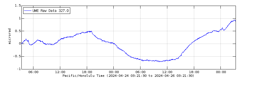
Could be the separation between two DI events that happen in close succession.
The upswing is too fast for the usual DI event. The decline could be part of one though.
It is only a very small change though, 1.5 microradian. Might be so small even that it is not a volcanic signal.
I hate to be a pain, but could some kind person please interpret these graphs for an absolute neophyte like me. I can tell that things seem to be dancing around in 3D, but I have no idea what this means in the greater scheme of things.
Thank you.
Seen on twitter…the current outlet is getting narrower and narrower. At some point we could see a reconfiguration, no idea which direction though!
https://pbs.twimg.com/media/E-J6uQtXEAAtOt0?format=jpg&name=small
Ah, there’s a larger version
https://pbs.twimg.com/media/E-J6uQtXEAAtOt0?format=jpg&name=large
Something I have noticed is a few of the shields seem to do a stage 4, if you can call it that. Basically towards the end of their eruption the rapid episodic eruptiosn return, sometimes even with fountaining. Pu’u O’o didnt do this, but Mauna Ulu did. For that example as well as most others I expect this stage occurs if the conduit seals, but not fully before resumed activity, effectively it resets back to an early stage in its dying days. It might be due to waning eruption rates and the conduit starting to close again.
There are a few true grand finale eruptions though, if you can call them that. Pu’u O’o might be a candidate because of 2018, but that can be debated. But in a few cases I have found shields that seem to have gone quite crazy at the end. Just to the north of Storaviti shield, debatably the biggest in Iceland, is a large spatter cone rampart and a partly tubed over lava channel of impressive size, clearly a much more powerful eruption than that creating the shield. This is not gravitational either, its quite puzzling, it really is as though the magma supply went up 100x at the very end maybe even just for a few weeks and the area has been nearly quiet ever since, only erupting once.
Trolladyngja and Skjaldbreidur, also similar size, seem to be a similar situation, maybe not as intense. No big fissure on the flank but both are mantled by extensive sheet pahoehoe and long a’a glows, which in general look to be younger than the pahoehoe at the base, all the products of fast moving lava just like we see today at Fagradalsfjall. These late stage lavas dont go beyond the shield base but still go as far as 13 km from the crater.
Really shows how big things can go, we have not seen anything yet if you ask me.
I also do keep wondering, at least for Trolladyngja, if it met the same fate as Pu’u O’o, being terminated in a flood basalt at Veidivotn.
That stage 4 activity you mention, Pu’u’o’o also had it, sometimes it produced small fountain episodes from vents in the crater that overflowed the cone, these were interspersed among the periods of constant effusion from the flank. That is why I consider this activity also part of Stage 3. The three stages are a simplification of the activity, these shield volcanoes have very complex evolutions, sometimes if the conduit collapses over it might rebuild as narrower openings and resume fountain activity. Return to a more Stage 2 akin activity, although of a smaller scale I’d say. So yes that can happen. But it seems to me that the final part of a shield eruption is generally dominated by constant effusion channelled into lava tubes, although more intense episodes may occur from time to time.
The Storaviti shield looks like it is a large shield volcano and an smaller parasitic shield, like Mauna Ulu and Alae, or Pu’u’o’o and Kupaianaha, or perhaps two overlapping shield volcanoes of different ages. But yes it is possible that some shield eruptions lead to culminating fissure eruptions. The Hallmundarhraun shield eruption of Langjökull seems to have preceded or been contemporaneous with the Reykjanes Fires, but there may not have been any true relationship between the two events. It is hard to find any definite connection in those cases. You would need a precise relative dating method, like paleomagnetism.
Map by HVO showing the unrest at Kilauea. The red circle is the source of deformation, most likely a sill intrusion I’d say. Earthquakes are happening in the Southwest Rift connector, an horizontal conduit that delivers magma towards Pu’u Koa’e and the Kamakai’a Hills. And apparently must be feeding this sill too.
As we all know there are lots of Darwin award contestants at the Iceland eruption, just got recommended this video, probably the closest call I’ve seen on video yet.. I don’t get how people think it’s a good idea standing close to a place where 1100+C lava is flowing at speeds much higher than you can ever run.. Like one good glob of that stuff hitting you… is something I don’t even want to contemplate.. https://www.youtube.com/watch?v=Eu0nIxahj3Y
RE: “As we all know there are lots of Darwin award contestants…”
There’s a video out there somewhere, shot during the PU’U’O’O’ era. of some HVO people standing close by a rapidly moving flow when it either jumped the bank or the bank collapsed and came at them full tilt boogie. They managed to escape. Every time I see some of that yellow>white hot lava shoot downslope here I’m reminded of that award candidate who climbed the slope of the cone months back.
There was a series of photos during one of the first episodes, in Royal Gardens. A big slug of lava overran an ‘a‘ā flow and caused Robert Decker, among others to haul donkey down a road.
Just theres also a video, unfortunately I could bot find it, but it shows a flank failure of early 1983 Pu’u O’o and a lava floid racing towards the observers they later panned back to show their tripod on an island in a sea of glowing a’a. Was when part of the wall blocked the channel, the fountain drowned, then blasted through like a geyser, sending the lava down towards the volcanologists…
I also remember reading someone actually fell into a lava flow back then too, they survived but it was close.
All the videos from that time are very scary. If that lava stream had left its bed at the top of that slope and formed a new stream further to the right, the people lower down on that slope would not have noticed that from below, until it came over the edge, at which point it would have been too late to run. So they would have been cut off or hit directly…
(then it turned out that indeed the lava had started to do that, luckily at very low flow rate, close to the end of the episode; but thankfully did not reach the edge of the steep slope (so far). It is in one of Gutntogs videos.)
It’s great to not restrict access and let people in on the action. Even letting them go onto the older lava; fine with me; it is stupid, everyone knows that there is some risk, they are just doing it anyway. But the situation on that slope is not so easy to understand for the tourists. It is my feeling that a lot of people were in a very risky location without having any idea that they were taking any risks. Maybe a bit of yellow warning tape would not be too bad…
1240 C its why fagradalshraun is so very fluid .. the high temperatures breaks down the sillicate polymers.
This lava is extremely fluid because of high temperatures, not very low sillica
Its so very fluid and bright yellow in daylight too before its surface quickly chill
This lava coud be perhaps even more fluid than Nyiragongos lava .. because fagradalshraun is much hotter than Nyiragongo .. that just pokes above 1100 C
Nyiragongo has no lava …. (These are FB links, same pic, not sure if they will work here)
https://www.facebook.com/photo/?fbid=1721625761561194&set=pcb.4277645085661310
RE:”Nyiragongo has no lava ….”
The pause that refreshes…
Nyiragongos lava lake column is gone for soure
Drained away
But Nyiragongo is an ultr-alkaline melt .. and souch melts are often relativly cool
Most Nephelinites in the world are around 940 to 1050 C. Nyiragongo is dark red in direct daylight
Fagradalshraun is 1240 C and can be bright yellow in direct daylight .. its an picrite ultramafic basalt .. much hotter
Daylight is brighter nearer the equator.
Yipes…
The best part, though, is that the guy sees the splashout downslope from him, sees he almost got fried, and so of course he doesn’t move, he keeps taking pictures.
Is there any chance that Fagradalshraun will turn Into a true central volcano??
Probaly will be a monogenetic shield feeding from a large pooled resovair deep down
The magnesium and titanium is still going up so the lava gets more primitive
Central volcano in Iceland means a place with a caldera, and usually but not always some more evolved magma. But I like to think of the whole rift as a volcano and the central volcano is where magma has collected. Think of Kilauea, it has got entire flank calderas and also some silicic magma far down the rift, but we arent going to call fissure 17 a central volcano. Iceland is different to Kilauea and has no molten core rift conduits presumably but the general idea is the same.
I guess this means Krysuvik and Svartsengi are actually central volcanoes, because they evidently have a magma chamber to drive the flood lava eruptions there, just it is too deep to make a caldera or evolve. Hengill is maybe this but more mature.. Brennisteinsfjoll though probably isnt, and neither is Langjokull today although it was in the past at some point. Central volcanoes are necessary for massive fissure eruptions but the whole fissure swarm can erupt on its own, which will be slow and make shields. Greater decompression after the Ice Age evidently create more shields. So basically shields are not usually going to turn into central volcanoes, though I do expect some are not entirely monogenetic, especially the biggest ones.
Its strange that Grimsvötn have not done a fagradalshraun or Surtsey Island in its caldera yet .. or a shield
Its the volcano with the most constant supply in Iceland.
But perhaps the shallow supply to Grimsvötn are really not that big at all
And coud explain the lack of shields
But Grimsvötn is constantly inflating all the time and There is complete lack of deep earthquakes and very little earthquake activity at all. A soure sign of an Open Conduit System
Grimsvötn shallow magmas are much cooler than Fagradalshraun 1110 C to 1130 C is the Numbers for Grimsvötn
Grimsvotn magma should be quite a lot like what we see on Etna then, fluid but not a thin liquid, and eruptions would be quite a bit more ashy and with massive fountains. Goes to show Laki was not directly fed by that magma chamber, that was hotter and more like the lava from Holuhraun, probably a deeper magma chamber that is hydraulically connected to Grimsvotn or maybe its deeper source. The eruptions at Grimsvotn in the 1780s were probably ring fault collapse eruptions, and maybe also subglacial rifts nearby.
2011 might then have not been entirely phreatomagmatic, it was probably going to be subplinian anyway.
The main magma reservoir is very much deeper. Grimsvotn erupts too often to build up a large shallow reservoir
A Grimsvötn caldera eruption that lasts long enough will build an Island and later go effusive
That thoelitic magma maybe Viscous and look like Etna a bit? 2011 was still a very crystal poor melt 5% crystals
I saw another drone video from yesterday
That’s the best video in the “circle the cone” genre that I’ve seen in several weeks. Thanks for posting it 67doug. It was nice to see the exact location of the Visir and MBL Close-up cameras. Both will be goners soon, if they aren’t already. I hope they get rescued.
I wonder if those cracks in Theater Hill are a result of the weight of the lava deforming the hill as the volcano embrases it.
The smaller fissure cones behind the monster are almost gone. Good views of Theater Hill and the cracks. Hopefully the camera infrastructure will get relocated soon.
Great videography skills.
Great video. Thanks for sharing. Our little volcano is not so little anymore. I kept expecting those people on top of Theatre Hill to break into some riverdancing. 😀
Looks like we’re going though another quiet cycle at Kilauea’s SWRZ. Maybe this cyclic activity should be called phase -1 or phase 0, referencing the above article. If this is normal.
What just happened is the reactivation of the SWRZ conduit after 40 years, not likely to be an immediate precursor to eruption but means despite the massive scale of the eruption in 2018 all the collapse was just a shallow collapse of the Halemaumau chamber and everything else is more or less untouched. The key factor is that magma still finds it easier to flow into a rift that hasnt erupted in almost 50 years than to keep filling a crater it erupted into just a few months ago and which is still deep. Clearly we have majorly underestimated Kilauea, if anything 2018 was not a termination of rift activity but an accelerator.
The view was improving but now it’s gotten worse again. Why is it behaving incorrectly? Once it started to improve it was supposed to continue improving until we had a good, clear view.
Hopefully it will clear, the Aurora forecast for tonight is good
Is fog just not a thing you understand the concept of. The area is out in the north Atlantic and elevated, the weather is also bad. The camera runs 24/7, there isnt anyone turning it off to piss you off. Even if it does do you have to go on here to tell us all about it? Its the only thing you ever comment about…
I took the comment as a good natured ‘oh crap, the view is lousy again .I think jumping down someone throat over it was an extreme reaction. Play nice !
I think you might have missed the at least 10 other times he has complained about the cameras being turned off as a conspiracy when it is fog. He has had warnings over it before
Glacial flood started in the Skafta river.
https://en.vedur.is/about-imo/news/flood-in-estern-skafta
Does this mean Grimsvotn is about to blow?
Apparently, it is something that occurs every couple of years or so, due to geothermal activity. Electrical conductivity increases started two days ago and you can also see changes in the nearby drumplots around the same time.
There is some background information on the webpage.
https://en.vedur.is/about-imo/news/flood-in-estern-skafta
Quote: “The Skaftá cauldrons, eastern and western, are located in the western part of Vatnajökull Ice-cap. They form because of geothermal activity that melts the glacier from below and water accumulates beneath them. When the hydro static pressure is high enough for the water to lift the ice above and flow from below the cauldrons it causes a flood. Floods from the eastern-cauldron are usually larger than the floods from the western-cauldron. Floods from the Skaftá-cauldrons as we know them today were first observed 1955 and since then 58 floods have occurred. On average floods from each cauldron occur every two years. Since then 58 floods have occurred. On average floods from each cauldron occur every two years.”
I hope Grimsvotn erupts so that everyone can stop talking about fagra-whatever and Kilauea
Do we want aircraft grounded at the moment?
RE: “I hope Grimsvotn erupts so that everyone can stop talking about fagra-whatever and Kilauea”
I find the impatience with the delay in the occurrence of natural disasters for the sole purpose of changing the conversation curious indeed.
I am burnt out with Kilauea and fagra-cone! There has been a decent amount of volcanic activity this year BUT all that has been set aside for some rather typical or smaller scale eruptive activity. The eruption at Reykjanes was cool for me but after the 10th article about it I am so done with it
Yes, we have been spoiled a bit. At the moment the excitement for me is in trying to understand what is happening underground in both volcanoes. Hector’s post is great for this. As for other volcanoes, Japan was very interesting too. I knew rather little about this area.
There was a vei-4 in the Caribbean only a few months back, I imagine Fukutoku will be a vei 3-4 when it’s done.
Cone flared up briefly around 23:10-11 but has since been dark again. Tremor seems stalled a bit below the 5K level. Wonder what’s going on?
It’s the fog rolling in and outmaking it appear and go dark again.. also seems so done has taken a nibble out of the rim of the crater.. On my phone so can’t post a picture but it’s showing up more and more now on langi cam..
so done = someone
+1 for so done.
And we’re off again…. (Geldingdalir / Ragnar)
There was a failure of the slope towards the north again, all of the lava is flowing into Geldingadalir on the far side from the camera, the old outlet is high and dry.
it is going to have to flow the long way but this could well reach Natthagi, it is a major flow diversion.
Isn’t Geldingadalir pretty much full already, seeing as lava has escaped it direct to Natthagi before?
If so, then my guess is that it’ll head for Natthagi soon if all the flow keeps going into Geldingadalir.
Lava reached the berm at the south end of Nattagi weeks ago, and it looks to me as if the occasional small flows we’ve seen into that valley since have raised the northern half. My hunch is we’ll see that berm tested soon. I hope I’m wrong, because if that berm is breached, it’s not far from there to the highway.
Yes, although the bit right at the n orth end is a bit of a depression I think, or rather it was before this past few hours…
It is, but when it was overtopping it was pretty much one big lava lake. So when lava was added on one end, it could immediately overflow on the other. Now the top of that lake has solidified, so any new flow will have to flow on the surface all over to the other end of the valley in order to flow out there. Which takes longer (And will build up a slope on the currently pretty flat surface).
So it might take several episodes to reach one of the exits towards Natthagi, depending on how focused the surface flow will propagate.
In addition, the old lake probably has contracted quite a bit due to the surface layers cooling, leading to a dip on the surface, and cracks. So that contracted volume has to be filled up first before the level rises above the previous.
Yes, it is not exactly the way it was back in June. I hope we get overflights soon, but the lake looks very substantial, think about that flood of lava back in July that went down into Meradalir, this is that but probably even bigger with how tall the cone is now. The back of the cone is also collapsing slowly, it will flow this way for a long time I think.
Bizarre: the Nátthagi cam shows a gorgeously colorful sunrise with partly cloudy skies, while the Langihryggur cam shows red lava spattering in the cone in the dead of night — everything not illuminated by the lava is pitch black. Both set to “live”. Both clocks showing a bit before 5:30 am Iceland time.
The Natthagi camera shows the glow of the erupting lava, not the sun, which should be rising well after 6 AM to the east, not NNE. The differences in background darkness are due to different camera sensitivity settings.
Dawn broke on the Langihryggur cam about 20 minutes later than on the Nátthagi one.
True, but one looked directly at the erupting column and the other only at the sky. The auto-intensity settings will be different.
I think they are all fake cams set up in a film studio to fool us volcano watchers …..just like the they ones used to fake the moon landing.
My guess it is being done by the same people who unleashed COVID on the world and is part of a plot to attract people to Iceland and infect them so they go back home and spread the virus.
Kilauea has play time
It is looking to be already building up again. There was no summit deflation with the intrusion, the caldera contracted but only by 4 cm, which is also how far CRIM moved north. If there was actual deflation of the caldera the Uwekahuna tiltmeter above would show a big dip, closer to 10 microradian or more but it doesnt, the signal now is within the range of DI events. Whatever is on your picture though is really weird looking, never seen that before.
There was also one shallow quake on the ERZ conduit, might be the start of more to come. The timeline to eruption seems short now. Probably still in Halemaumau just now but possibly expecting the deep pit to fill before rift eruptions begin is a risky undertaking.
The northwest part of Geldingadalir is a total lava lake now, will not be long before I think we see it flowing over the edge towards the timelapse cam as well as to Natthagi, if it is not already flowing that way. Definitely needs to be a webcam put this side again.
Nyiragongo is not the hottest lava …
Look at it in daylight.. its very dark red
Its probaly quite cool perhaps a 1000 C
But its a superalkaline melt and these are often very cool
Fagradalshraun and Kilaūea is much much much hotter .. they are mantle Thoelitic – Picrite melts .. bright yellow
Don’t know whether Nyriagongo’s lavas are the hottest, but she can produce melts of c. 1360C and 1320C near the vent / fissure.
Correction: Nyiragongo.
No.. No .. the summit lava lakes are NOT 1300 C .. the lavas color is not bright enough in daylight https://m.youtube.com/watch?v=htY8nVrT57o
Nyiragongos lava fountains is very very dull coloured in daylight.. cherry to dark red .. suggest perhaps little over 1000 C perhaps 1100 C. In the lava lake papers Nyiragongo haves a temperature of barely 1100 C.
Nyiragongos magmas are formed by very very very little partial melting, so they should be quite cool.
Most other Nephelinites erupt at around 980 to 1060 C as very viscous strombolian eruptions like sugarloaf flows in Oahu
Nyiragongo is Probaly quite hot for being a Nephelinite at around 1100 C perhaps
Hi Folks,
A Logistics Question. Which Helicopter Company is landing on Theatre Hill near the eruption site?
Thanks
Richie
Do you promise to return really good pictures that satisfy the lurkers in this forum, in return for this info? 🙂
More like: do you promise to fix the camera on Theatre Hill!
That would also be an applauded endeavour…
I think they all do, if weather permits.
nordurflug iceland is the blue one that is regularly seen on the hill
I have not noticed them in a while, but Heli Austria Iceland (also blue) was there very recently.
But like you say, they probably all do (as long as the landowner situation allows for that). And if not, then it is just a question of paying them enough 🙂
https://m.youtube.com/watch?v=BA-9QzIcr3c&feature=emb_title
Looks like the lava maybe flowing in lava tubes perhaps
http://brunnur.vedur.is/myndir/listi/webcam_meradalahnukurSSV.html
New flank vent in Geldingadalir, just like what happened in July.
Cannot see any lava but perhaps next episode will show that
It is on the right side of the cone behind the shield, you can see the big lava pond in Geldingadalir. There was also an overflow around the same time in this direction but most lava was from the flank vent.
At 01.23 there was a collapse of the southwest rim. This ties in with the breach and drainage event shown on the Meradadalir stills cam in Chad’s post immediately above. Which came first, the drainage or the collapse? Chicken and egg…
This weird structure of the edisodes (The spike during the rise of activity at the beginning, and then the “hump” on top during the high-activity period) has been very pronounced in the most recent episode. I wonder what causes it. Must have something to do with some underground processes filling up voids with gas or so.
The spike also makes me think of a small air hole in something like a bottle, releasing air/gas, that then gets blocked.
Katla had a small twitch ..
https://en.vedur.is/earthquakes-and-volcanism/earthquakes/myrdalsjokull/#view=table
New Kilauea interferogram out:
https://www.usgs.gov/center-news/photo-and-video-chronology-k-lauea-september-1-2021
Is anyone able to overplot the earthquakes on this diagram?
This is just an apprimation showing today’s quakes + the interferogram (simply aligned the two maps manually)
Thanks! This shows very nicely how the earthquakes are a boundary fault to the intrusion.
That’s a sill, an horizontal intrusion, perhaps with a slight dip to the southeast. There is barely any deflation of the summit, only one fringe away from the satellite near the centre of the caldera.
Seems to be a small shallow earthquake swarm of around 17 earthquakes south of Reporoa volcano in New Zealand. Not sure if it will continue or wane?
There is a hydrothermal area south of Reporoa, and a big power plant, maybe drilling quakes. Reporoa is probably inactive, it gets sometimes intruded by basalt from Tarawera but that hasnt made it erupt.
Ah, that makes sense. I saw the swarm but had no idea what else was around that area.I’d seen kind of similar swarms around the Geysir volcano in Iceland and Clear Lake CA in the past but in those scenarios I knew that they were either geyser/hotspring related.
I can’t seem to bring up either the Nátthagi or the Meradalir cam now, just the Langihryggur one.
Why?
Maybe because you complain about the cams so much.
He’s obviously trolling and y’all keep falling for it…
Not sure any troll can be considered obvious, it seems he is taken seriously enough to avoid getting banned or otherwise taken by the spam filter.
Well here we go 🙂
which side of the volcano is the break? on the ‘backside’? NW?
Proud of myself. (hahhaha) i guessed right by recalling by memory the volcanoes side and profile… and opening the You tube i found the discription…. now why can’t i remember where i put my keys or why i can into any room of the house. ??? 😉
What is referred to as fissures in the lava lake is most likely just the lava filling voids in the existing lava flows. Gas in the voids is displaced by the lava and bubbles to the surface.
There were lots of this back in April when lava covered existing flows, especially around the edges of the new flows.
Into Geldingadalir, near the old cones from the fissures in April. The mountain above the lake is Fagradalsfjall, so it is basically flowing into the only bit of the whole area that has no live camera view… 🙂
Should add this was only 1.5 hours after it happened, it kept going for the entire duration of the episode, there is a lot lf new lava there now .
for some reason I neither see a link nor the page to (video?) in your recent posts, but clearly others do.
Odd.
It just appeared, odd. Worth the wait though.
There is some strong tremor at Kilauea now, on all of the summit seismometers.
That’s interesting, if I’m correctly understanding what that means (possible maga movement?).
The reason I find that perplexing if so is earthquake activity at the summit area (and the previously active area to the immediate south) seems to have gone silent. Wouldn’t actual magma movement cause some quakes?
Simply put, breaking rock causes quakes, moving magma causes tremor. If the rock is already broken you don’t get quakes. We saw at the start of the Fagradalsfjall eruption that there can be a silent period just before an eruption starts. The final push was basically silent and just when people started to think the event was all over, lava broke through.
It will cause quakes if it is stressing the ground, so there is no new intrusion but it would seem this one is not over yet, just all the pathways are open. It is a sill, so it cant erupt directly, but I expect if this keeps going it will lead to something, either immediate future or as a long term process of activating the SWRZ to become a dominant eruptive area in the future.
It is really hard to see the activity here, because basically all the surface of the SWRZ is made of the summit derived Observatory flows and tephra above that, but underneath those there seem to be a lot of the same narrow fast flows we see descending the cliffs from the ERZ which would indicate more standard activity on the SWRZ, which we have just not seen because of the short historical window, and actually one flow that looks to be quite big where it flows to the sea.
The tremor episode at 15:06 UTC has been recorded widely over the island, a deep source is more likely, probably from Pahala. The rest is probably noise local to certain stations.
Meanwhile the UWE tiltmeter keeps doing those weird ups and downs:
https://www.usgs.gov/volcanoes/kilauea/deformation-data
SDH has been flat for a while now, the intrusion seems to have ended around August 30.
Regarding your theory on the cause of DI events, maybe the recent weird signal on the tiltmeter is the DI signal of magma chambers in the SWRZ. Those would not have been active for a while and not showing, now they are?
That could be possible.
Going back to the jökulhlaup that IMO reported yesterday on the Skaftá river, it not the usual location for a jökulhlaup from Grímsvötn (that would be Skeiðarárjökull based on the Gjálp eruption). So which volcano is responsible? Bárðarbunga, Háabunga or Grímsvötn?
Theres a subglacial lake that does this every few years I think, I dont know if it is related directly to volcanism, more a hydrothermal thing that is just when you have that occurring under a glacier.
It comes from the Skaftá cauldrons. They are two geothermal features where melt water from geothermal heat accumulates and drains on a regular schedule. About every second year there is a jökulhlaup from these cauldrons. Here’s an article with some detailed information.
https://www.researchgate.net/publication/318250982_Subglacial_flood_path_development_during_a_rapidly_rising_jokulhlaup_from_the_western_Skafta_cauldron_Vatnajokull_Iceland
And of course IMO has some information about the current event:
https://en.vedur.is/about-imo/news/flood-in-estern-skafta
At the bottom there is a short description of what the Skaftá cauldrons are.
Interesting paper. But what is the heat source for the geothermal activity. Magma relating to one of the above volcanoes, or the mantle plume?
https://m.youtube.com/watch?v=kSxe0kPVs-4
https://m.youtube.com/watch?v=hGd-7adn00c
https://m.youtube.com/watch?v=K75op0aO9qU
Fagradalshraun is a very fluid lava for soure
One of the most fluid sillicate magmas ever seen! Its very fluid and gas rich and kind of foamy.
This lava haves its low viscosity because of high temperatures 1240 C and that breaks down the sillicate polymers in the melt
Its even more fluid than Holuhraun..
Thanks, Jesper! These are Great! Better than being there! i was missing the eye candy and these give such a comprehensive view of the whole place… wonder what is happing in Theater hill tho, Those cracks are really disturbing.
Somebody give that volcano a cup of joe.
My prediction: the volcano will remain dormant until experts start declaring that the eruption over.
He’s dreaming. Of a world without having to perform this pointless fire shtick over and over.
I’m hoping the longer the nap the more energetic it will be when it wakes 😀
Could someone in the Reykjanes area please pop over to the eruption site and reboot the volcano, if it can’t be done by remote desktop administration? It seems to have locked up.
Next chapter: askj ?