During August 2021, reports came in about an eruption in the ocean south of Japan. The volcano was new to me: Fukuto okanoba. It sounded like something from star wars. It was a friendly explosion, meaning no one was inconvenienced by it. The submarine explosion had produced a tephra raft 60 km long, plus an ash cloud reaching 15 km high. Afterwards, it turned out the eruption had already been in progress for a few days before the explosion and had created new land – an island 1 kilometer across. The final explosion has created a large crater in this new island, and had reduced it to a rim. Perhaps this shouldn’t have been listed as a submarine explosion, even though there had been nothing but sea here just a week earlier. After the explosion, there was no further activity.

PlanetScope imagery, August 17 2021. There is activity in the very centre of the crater. The crater has a diameter of 630 meter. The island is twice that size.
The remnant island produced some nice images. This is the best one I have found: a Planetlab image taken on August 17 showing the island and the beautiful circular crater with a diameter of 630 meter. Something is bubbling up in the precise centre, as if to say ‘oops, sorry’. On the right, wave erosion is already carrying bits of the island away into the ocean, causing a brown discolouration, while the central spout is turning the water green.
The image allows us to estimate the size of the explosion. The crater is a decent size but does not appear to be very deep. Assuming an optimistic average depth of 100 meter, and assuming that the island itself was created just days before from volcanic ejecta, i.e. quite low density and unconsolidated, it gives a tephra volume of 0.03 km3. If instead the crater is a bowl (a half sphere), this becomes 0.06 km3. This estimate puts the explosion at a VEI 3 level. The activity in the preceding days which had created the island would have been a bit bigger, and perhaps have reached 0.1km3 – a high-end VEI 3. The extensive area of floating debris may have even been created in part by this previous activity.
We learned that this was in fact a known volcano. The Japanese name, Fukutoku-Oka-No-Ba, was not its original name: an older name existed for the same submarine volcano, Shin-Iwo-Jima. This volcano had history. The old name meant ‘New Iwo Jima’ or new sulphur island. Iwo Jima is the (old) name of the well-known nearby volcanic island, so this name just meant ‘new island near Iwo Jima’. The old name show that this volcano had already created an island once before. When that island turned out to be ephemeral, the old name lost its meaning and the undersea mountain received its new name.
There have been several eruptions here in the past century. The ‘new’ island appeared after an eruption in 1905. Other confirmed eruptions occurred in 1914, 1973, 1974, 1986, 1987, 1992, 2005 and 2010. They were mostly small, at VEI 0-2. The 1904 and 1914 eruptions are classified as VEI 3, the same as the recent explosion. The 1986 eruption also created an island: the current incarnation is the third such island in 120 years. The islands do not last long: they tend to disappear under the waves within a month or so. The Pacific ocean, and in particular its cargo of typhoons, is not friendly to intruders. There are more reports of eruptions but they are unconfirmed, and they may be fumarole activity discolouring the sea water. This was seen several times in the decade after the 2010 eruption.
The culprit lies underneath the waters, save from the Pacific fury. Fukutoku-Oka-No-Ba is a highly active undersea volcano, which has a peak some 15 to 30 meters under water. The depth varies with each eruption, but it will always stabilize at the depth to which wave erosion can reach. Over time, the waves form a plateau at some 30 meters depth. The eruptions build on this plateau – but only temporary, until the sea reclaims its property.
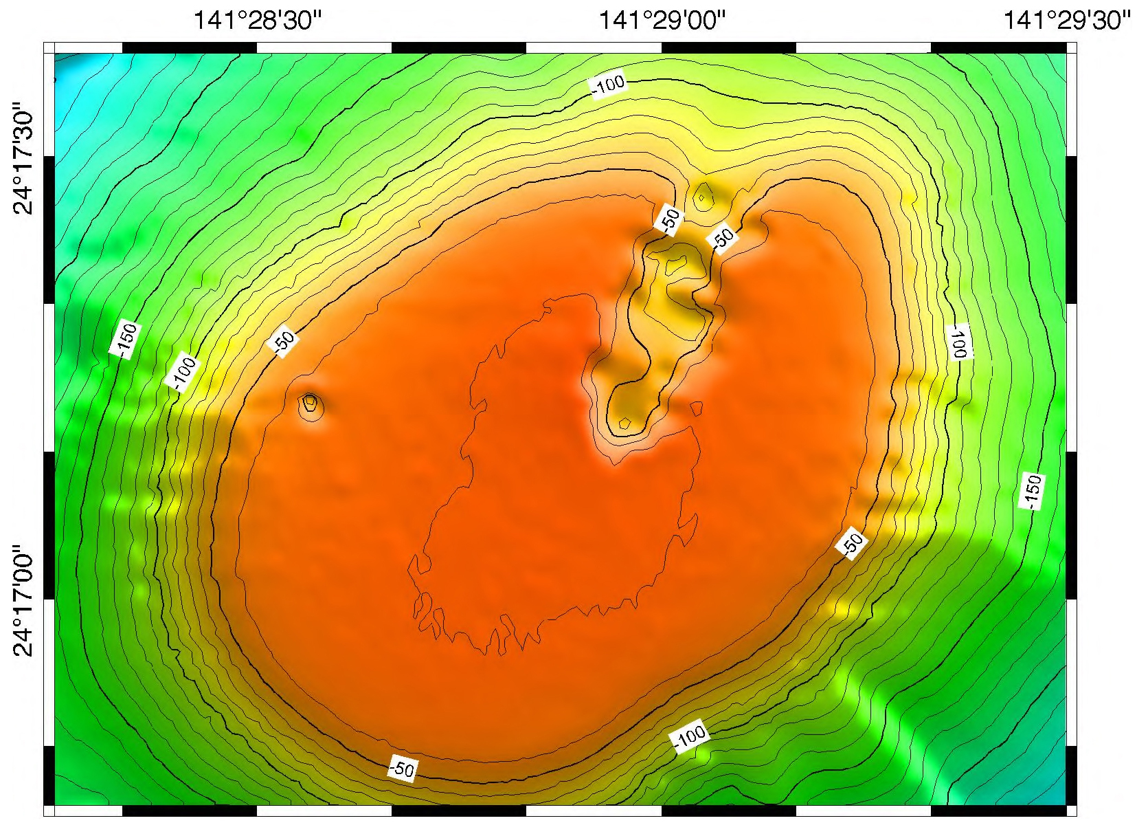
Source: Smithsonian Global Volcanism Program. The region within the -40m contour (the flat bit) is 1.2 km in diameter
Taking the bathymetry and overlaying the new island gives the following result. I tried to get the scale correct, but the precise position is not as certain. In fact I shifted the coordinates by 30 meters to avoid the new island going over the edge, and put the vent in the centre of the plateau. The precise PlanetScope coordinates would put the vent 30 meters further to the north-northeast, along the apparent rift. The steepness of the slope outside of the -50 contours makes it more difficult to create the new island at that location. The deep hole visible in the bathymetry near the western edge of the plateau now nicely coincides with the indentation of the island. A 30 meter error in the latitude coordinates of the bathymetry map is perhaps acceptable. However, this does not mean that my positioning is correct! Feel free to move the island around.
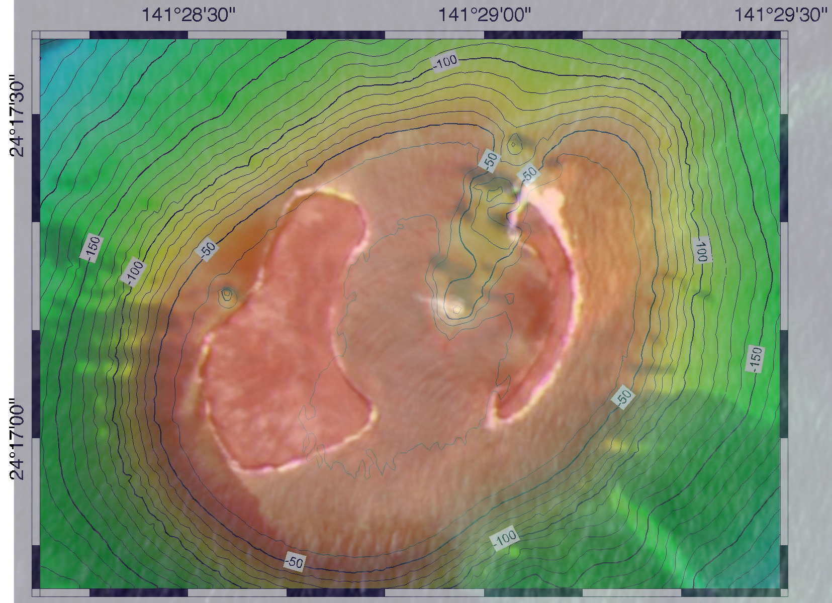
Overlay of Planetlab and bathymetry
The neighbourhood
This is clearly an impressive volcano, and a very active one. It is not huge. The ocean here is deep, 2 kilometers or more, but the volcano is sitting on a larger plateau which rises far above the deep sea floor. The base of the volcano is around 400 to 500 meter deep, and around 5 km in diameter. We are talking about a 5 km wide, 500 meter tall volcano with a 1-km flat top and a 500-meter rift running from the centre. Without wave erosion, we can estimate that the top would have been about 100 meter above sea level.
It is not the only volcano here. Just 4 kilometers away is Minami iwojima, a steep extinct cone reaching a height of 900 meters above sea. It dwarfs our exploder.
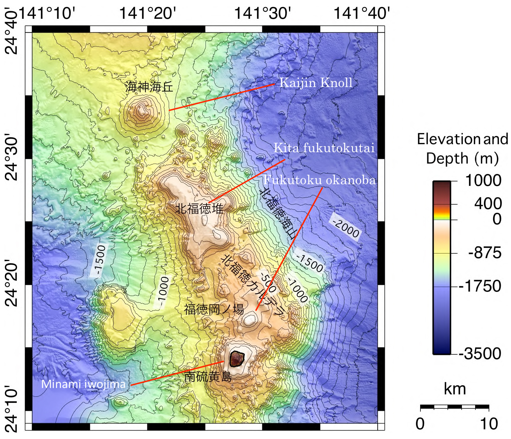
The map shows the underwater view. There is a 25-km long, bendy ridge with several distinct peaks. Minami iwojima is the dominant one, but there are three other named peaks, all of which reach to just below sea level. Wave erosion has gotten the better of all of them. Only Fututoku okanoba appears active. There are a few other, unnamed peaks, and to the west is a larger flat-topped ridge which is 700 meters below sea level: the depth suggests this ridge has suffered subsidence.
Remember that rift in the summit of Fukutoku okanoba? Extend it the other way, and it points directly at the extinct cone of Minami iwojima. Our volcano is either a satellite of Minami iwojima, or its structure has a fault caused by it.
The arc of the Volcano Islands
The two islands are part of a larger volcanic region. These are the well-named ‘Volcano Islands’. There are four – now, temporarily, five – islands forming a 500-km long but sparsely populated chain. The chain runs from 800 km to 1300 km south of Tokyo.

The five islands are Minami iwojima, Fukutoku okanoba, Iwo Jima, Kita iwojima and Nishinoshima. Iwo Jima (renamed to Ioto in Japan) is 60 km north of Fukutoku okanoba, Kita iwojima lies 80 km further north, and finally Nishinoshima is 200 km further – a bit further but it seems to belong to the group. There are also more submarine volcanoes, about 500 meters below sea level: Minami hiyoshi, Nikko (about 50 and 100 km south of Minami iwojima), and three near Nishinoshima: Doyo seamount 50 km to its north, and Kikata and Kaitokyu seamounts 50 and 100 km to its south. Finally, there are some submarine vents near Kita iwojima. Together with the Volcano Islands, they form the central, active part of a 2000-km long series of volcanoes (many of them submarine) stretching from Japan to the Mariana Islands, with volcanoes typically 50-60 km apart.

There is a second string of islands 100 km to the east, with as largest one Chichijima. These are called the Bonin islands (meaning ‘uninhabited’ which is no longer fully correct). The term Osagawara islands is also used for these islands.
Of the Volcano Islands, Minami iwojima and Kita iwojima are quite similar to each other. Both are steep cones of similar height (913 and 792 meters) and size (2 km across), have sea cliffs of several hundred meters tall, lack any sign of current activity (no fumaroles or hot springs) or recent eruptions. Both consist of tholeitic basalt as expected of oceanics arcs: they are extinct tholeitic stratovolcanoes. The ages are not known, but may be as much as a few hundred thousand years. If they are old, they may have originally formed as submarine volcanoes and reached their current height by uplift. However, this is speculative.
The other three islands are lower, lie just below or above sea level, are flat-topped, highly active with vents and frequent eruptions, and have alkaline lavas which are indistinguishable between Iwo Jima and Fukutoku okanoba. Nishinoshima also erupts alkaline lava but of a slightly different composition. Nishinoshima had a long lasting eruption from 2013-2020, 40 years after the previous eruption, which made the island much larger. The original island has been above sea level since at least the 16th century. Iwo Jima shows phreatic eruptions with active fumaroles, and has been inflating for hundreds of years at typical rates of 2 meters per decade. It had a significant eruption perhaps 2500 years ago. Fukutoku okanoba erupts every few decades, at times forming an ephemeral island. The new volcanoes are very different from the previous cones. There has been a change of the guard, out with the old and in with the new.
What is going on? And why are these volcanoes here, in the middle of the ocean? For that, we need to get to the bottom.
The Battle for the Pacific
The Pacific Ocean has a violent temper. Above, there are the frequent typhoons which are probably the main reason that the Volcanic Islands find it so hard to grow up. Underneath, it is fighting for supremacy with smaller plates all around the ocean. One of those battles is taking place near the Volcanic Islands. And this battle is not going well for the Pacific plate.
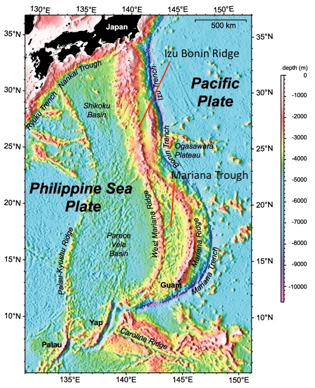
The Pacific plate covers much of the Pacific ocean. It is an old plate which has ruled its kingdom for a long time and does not take kindly to competition. But new plates are growing, younger and hotter and more nimble. The Pacific plate is being challenged. In this particular region, the challenger is the Philippine sea plate. It is still young(ish) but already heavily scarred by the conflict. From west to east, we find the Palau Kyushu Ridge (known, obviously, for Palau), a wide basin called the Parece Vela basin in the south and the Shikoku Basin in the north, the West Mariana Ridge which becomes the Izu Bonin Arc further north, another basin, the Mariana Trough, which is in the south but with a similar smaller basin in the north called the Ogasawara Trough, the Mariana Ridge (home of Guam), and finally a deep trench, called the Mariana Trench in the south and the Izu Bonin (or Izu Osagawara) Trench in the north. This trench is the boundary between the Philippine and the Pacific plate. This is where the Pacific plate is subdued by the challenger.
Subduction and roll-back
In this region the ocean floor of the Pacific plate is around 150 million year old. The Philippine plate has a variety of ages, but in this area is typically 50 million years old. The Pacific plate is much older and therefore colder and denser, and in the collision zone it is the one to subduct. Old crust, once subducting, sinks steeply. This causes all kinds of problems at the surface.

Nyu et al. https://yaolingniu.webspace.durham.ac.uk/wp-content/uploads/sites/234/2021/04/2014Niu-GTM.pdf
The cartoon illustrates the process. The red bar is the Pacific plate, and grey plays the part of the Philippine sea plate. T1, T2 and T3 are three different times. Over time, more of the Pacific plate begins to subduct, and the location where the sinking begins is moving backward. This leaves a gap, and the Philippine has to move in to fill the gap. Near the boundary between the plates a ridge develops: an arc. In front of the arc is the trench formed by the sinking plate. Behind the arc, the plate is stretching and thinning in order to be able to fill the extra space. This forms a basin.
Why the backward movement of the trench? This is because the sinking plate is down the creek with a paddle. Initially, the subduction is fairly shallow. But over time it becomes steeper. The subducted slab is now moving downward and backward, like a paddle moving through the upper mantle. The mantle underneath the Philippine plate has to move forward to fill the vacuum created by the paddling plate, and it pulls the Philippine plate with it: it is sucked forward. The trench begins to move backward.

This steepening is very notable along the Izu Bonin Trench, where the angle has reached 55 degrees, and even more so along the Mariana Trench where the Pacific plate descends almost vertically.
The paddling causes the trench to retreat. The Philippine plate now has to fill more space. That is fine if there is a spreading centre creating more crust, but when there isn’t one, the extra space is filled instead by thinning of the crust. The thinning crust sinks and a basin forms. Below the thin crust, the magma can circulate up and a weak spreading centre may form.
Basins and Ridges
This happened in the Philippine sea plate 30 milion years ago: it formed the Parece Vela Basin in the south and a little latter the Shikoku Basin in the north. But the basins eventually ran out of magma and spreading here ceased 15 million years ago. So the process repeated, and around 7 million years ago the Mariana basin began to form, closer to the front. At the moment this basin is 1000 km long and 200 km wide; it is widening by 2 to 4 cm per year. Further north no new basin has formed (so far, at least). The Philippine sea plate has a bit of clockwise rotation, and it is pulling away a bit from the Pacific plate in the southern region. This has made the whole process faster in the south. The Mariana Trough has become so pronounced that it is sometimes considered as its own micro plate, and the adjoining trench, the world famous Mariana trench, now contains the deepest surface on Earth. As Bond would say, straight down, with a twist.
The Philippine sea plate is a mosaic of ridges and basins. The ridges are (or were) volcanic arcs. They formed in the usual way: once the subducted plate reaches a certain depth it will begin to melt. The melt percolates up and forms a chain of volcanic islands, typically 50-200 km from the plate boundary. The basin forms adjacent to the trench, in between the volcanic arc and the plate boundary. Every time a basin forms, the volcanic chain begins to move away from the plate boundary and the volcanoes become extinct. This has happened to the Kyushu-Palau Ridge which became extinct 25 million years ago, and to the West Mariana Ridge 7 million years ago. A new volcanic arc will form, at first widening the existing arc and later as a separate arc. The spreading centre moves away from the subduction front as the crust stretches, and once it has moved far enough that the volcanic islands form between the spreading centre and the front, they can grow in one location. This can take a few million years. The Mariana Ridge has formed such a new volcanic arc. The Izu Bonin Ridge has not yet done so.
There is another process to consider. A ridge can also build up adjacent to the trench, pushed up by the collision with the subducting plate. Behind it, the descending plate can pull the overriding plate down, causing a trough in front of the volcanic arc. The pushed-up ridge is the forearc, and the trough is known as the forearc basin. There is one such basin in our area: the Ogasawara Trough. The Volcano Islands are one the west side of this trough, and they form the volcanic arc. The Bonin Islands are on the other side, on the pushed-up ridge next to the trench. The Bonin Islands are not volcanic, although like all ocean floor, they are created from lava.
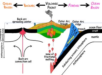
forearc and forearc basin. Source: Wikipedia
When looking are the mosaic of ridge across the Philippine sea plate, it is worth remembering that originally there was just one ridge, but every time a basin formed in front of it, eventually a new volcanic ridge had to form.
The subducted plate consists of normal oceanic crust. When it melts during the subduction, it forms thoelitic basalt (a mafic mantle melt). This is the type of basalt found on the two extinct stratovolcanoes in the Volcano Island chain, and widely elsewhere along the volcanic arc. But why does Fukutoku okanoba have a different lava, even though it is next to the tholeitic (and extinct) Minami iwojima? And why is this same lava found on Iwo Jima – and nowhere else?
Shoshonites
The lavas of Fukutoku okanoba are alkaline (not mafic) with an SiO content of 60%, high potassium and sodium (9% together), and low calcium and magnesium. They are so-called ‘alkaline shoshonitic lavas’, and the area where they are found is called the ‘alkalic volcano province’ – it coincides with the Volcanic Islands.
The name may need some explaining. Shoshonite is a type of rock: a potassium rich, basaltic trachyandesite. Its name comes from the Shoshone river in Wyoming, after this type of rock was identified in Yellowstone. Trachyandesite is a rock with about 60% SiO2 and about 9% K2O+Na2O, low in magnesium and iron. ‘Basaltic’ means it was erupted effusively (normally with low viscosity) and cooled rapidly at the surface; basalt has a bit lower SiO2 (less than 53%) so this is ‘basaltic’ rather than ‘basalt’. Shoshonite is present at Fukutoku okanoba and at Iwo Jima. Nishinoshima has similar lava but it has less potassium and a bit more magnesium and iron: it is an intermediate between typical arc lavas and the stuff found at Fukutoku okanoba.
It is still a bit of a mystery why this particular region has this peculiar lava. It is a recent change, because the extinct stratovolcanoes here show normal lavas. Something has changed.
Shoshonite is found at the Hiyoshi submarine volcano at 23 degrees north, at Fukutoku okanoba, and at Iwo Jima at 24.8 degrees, with a transition zone to Nishinoshima further north. This is precisely the region north of the Mariana Trough. The oldest shoshonites are found in the south, adjacent to the Mariana Trough, dated to 3-4 million years ago, while the youngest are obviously from the two currently active volcanoes further north. It is tempting to link this to the northward spreading of the Mariana Trough. The trough is a few million years older than the oldest shoshonites. Is this the delay between spreading and the formation of a new volcanic arc? Is the region of the Volcanic Islands getting ready to join the Mariana Trough?
A change of melt
It is not immediately clear why basin formation would change the composition of the magma. Neither is it clear why the volcanoes are at sea level (with possible uplift) if a basin would be forming. Is there an alternative explanation?
If a small spreading centre is forming, the mantle heat may recently have increased, and caused some uplift. Volcanic arcs form from melt of the subducted plate. If there is more heat, there may now be a partial melt of the wedge between the subducted plate and the Philippine plate. The alkaline lava suggests a low melt fraction.
Here the forearc trough comes into view. The Volcanic Islands are along this basin: can this be part of the problem? The forearc basin is pulled down by friction with the subducting plate. Erosion can occur: material is pulled off the bottom of the Philippine plate and carried backward by the descending plate, enriching the mantle material in this wedge. This could explains some chemical peculiarities. The change of melt source must have occurred recently, over a 200-km long arc. This makes an origin in the Osagawara forearc basin plausible. But the true source of the shoshonitic lavas remains an unsolved problem, somehow related to the battle of the plates.
Shoshonitic lava can form when oceanic magma crystallizes at higher than usual pressure. Either olivine or orthopyroxene can crystallize, depending on how much water there is in the rock. If wet, olivine forms which increases the potassium and silicate in the remaining melt. Shoshonitic lavas are found in different locations. Some are associated with a continental margin, related to crustal thickening. This is seen for instance in the Andes, Kamchatka, or the Eolian arc north of Etna. The high pressure at the base of the thickened crust causes the shoshonite to form. The second location is in island arcs which are becoming unstable, for instance when subduction is ceasing or changing direction. They appear to be a late phase in the evolution of an island arc, perhaps related to a deepening of the subduction melt.
Perhaps the paddling movement of the subducting plate is making it deeper, with the melt now forming deeper and at higher pressure. A second possibility is that spreading is indeed taking place, move the current volcanic islands further from the subduction zone, and therefore higher above the subducting plate. Perhaps the forearc basin is beginning to become a spreading basin taking up the retreat of the subduction front and the Volcanic Islands will have to move east, until they pass the new spreading centre and find a new stable location – forming a new volcanic arc, with the current arc becoming one more scar on the Philippine plate.
Speculating further, why have Fukutuko okanoba and Iwo Jima become so active? The removal of olivine from the melt may make it more buoyant, causing the residual melt to rapidly rise into much shallower magma chambers. The amount of magma may not be as high, especially if the arc is beginning to be starved of magma, but what is there would reach the surface easily and regularly giving frequent but smaller eruptions. As happened this month.
If any of this speculation is correct, changes are afoot in the Volcanic Islands, perhaps as soon as in the next hundred thousand years. Keep posted.
VC has long been fascinated by Iwo Jima (Ioto) and its extreme inflation. Now we have seen its sibling erupt. These volcanoes may or may not be tracing the beginning of a rift, which will eventually extend the Mariana Trough. Either way, it is all part of the battle for Pacific supremacy between the ancient Pacific plate, ruler of all, and the upstart (now middle aged) in the west. Our volcanoes are driven by events outside of their control, and their eruptions are collateral damage in a titanic battle. We might call that friendly fire.
Albert,August 2021


Before summer I said that this summer would be really stressful (it was, and slightly still is, I’m quite a few articles behind here), and to relax/recover I had plans to go to Iceland to do some volcano hiking and such.
However I’ve just busted my knee, nothing terminal, but it will require rest for a whole bunch of weeks and no excessive usage… So Iceland trip plans has gone down the drain for the time being.
On the plus side, it should give me time to catch up on some reading here in the Café.
Oh, bad luck. Knees take a while to get strong again so take it carefully.
My wife broke her ankle in the snow in January. Turned out it needed pinning. it was May before she felt ready to walk out and it was a long road to recovery. She still favours the ankle a bit as it hurts even now.
OO Hugs!
Regarding the Fukutuko-Oka-No-Ba eruption, is there a way to get an updated photo from PlanetScape? …ran into a paywall..:<
Not really, unless you have an account through their education program or are associated with a research funder which has an agreement with them
There is tremor at Kilauea, as in actual volcanic tremor. No new earthquakes on the map though.
And on Mars.
https://www.jpl.nasa.gov/news/my-favorite-martian-image-helicopter-sees-potential-rover-road-ahead
Meanwhile Perseverance has closed to within 350 metres of Ingenuity and has stopped at “Rochette” rock for a planned next sample attempt. Better luck this time. Fingers crossed 🙂
https://www.jpl.nasa.gov/news/nasas-perseverance-plans-next-sample-attempt
As per Gutn Tog’s recent video, the faster, narrow ribbons of lava are close enough to shore to be in reach of a good fly cast. With tungsten wire line and fly of course, and tungsten rod guides and reel spool. Someone needs to do it. It would be possibly the furthest anyone ever pushed “You never know.”
Have a word with Sigga! S/he’s in the area. New VC experiment. What could go wrong? 🙂
Tungsten not a good choice, oxidizes easily and gets very brittle. Plus expensive. Can probably get away with a nickel-iron alloy wire depending on the exact temperatures. Guide rods, spools etc, can be ceramic.
Really theres a lot of petals, stainless steel would work fine. If you really want longevity go for iridium, though that might be too rigid to make a wire out of.
Kilauea at it again, only 2 days after the last swarm, the intervals are getting shorter…
Perhaps it was a little too soon to lower the alert level?
The south caldera swarm has suddenly restarted and SDH is picking up rapid inflation again. It looks like the swarm paused with the start of a small DI event, and that with the end of this same event the swarm has resumed. It also looks like Kilauea has been in a large DI event for almost 3 weeks that has now ended, with two small events nested in the large one. This is getting more and more puzzling by the time. I have no idea what is going on. Intrusions do not look like this, I doubt this is any conventional magma intrusion.
For those of us, like me, who do not know what a DI event is:
https://www.usgs.gov/center-news/volcano-watch-di-events-k-lauea-what-are-they-and-what-do-they-mean
I have given a lot of thought to DI events, thought about many possible explanations. My preferred idea is that it is caused by portions of the magma chamber’s wall breaking away, sliding across the floor, and then plunging into the main conduit of Kilauea. It removes a volume, the missing portion of rock, causing deflation, however Kilauea’s system as a whole does not suffer any net volume change, so it rebounds at the end of the DI event and re-establishes equilibrium between the various parts of the system, the magma chamber re-inflates.
The hypothesis works well with simple DI events. There are things that I’m still not sure how to answer though. Like a particular variety with a large inflation spike called DID event, or what happens to all the volume that plunges into the conduit? or what exactly is going on right now with the ongoing swarm?
I’d guess (and it is a guess) magma ascent is not smooth; you could get a blob of magma rising then cooling to fall back a little bit as it loses momentum, its density increases / it loses some buoyancy, to be pushed up again as the next blob arrives?
Does degassing have some impact too?
Suspect it is not simple because there is more than one process going on.
This is me speculating:
The 2018 eruption and summit collapse most likely disrupted/destroyed whatever structure kept the relativity stable 30+ year eruption going.
Now the magma has to chart a new path, burning new conduit/dikes through the summit zone. My guess as to what is happening here is as magma charts its new paths, it occasionally finds old voids/tubes/chasms. When it does punch through to one of these it has to occupy, fill and pressurize the space. During this time the signals abate. Once pressure equalizes, the magma then starts to look for the next weakest path, and rock breaking signals return.
I can certainly dig that. Not every major collapse will result in the same outcome, though.
After 1924: Seven small eruptions, all in Halemaumau until 1934. Intrusions in 1938, 1944 and 1950 until a large eruption in Halemaumau.
1960: Three small in Halemaumau in 1961, followed by MERZ small eruption later in 1961, several more 1962-1969 and Halamaumau 1968…until Maunaulu.
After 1975: One small caldera eruption immediately after the earthquake, moderate one on the MERZ 1977, small UERZ in 1979, micro-eruption in 1980, UERZ, two small in caldera 1982 (concurrent with a lot of intrusions, some large)…and then Puu O Oo.
2018: Large EQ during the eruption, collapse concurrent with the eruption, (both stopped about the same time), small summit eruption two years later.
Point is, I’ve stopped looking for patterns. Ma Nature’s going to do what She wants to 🙂
Back in 2018 the central conduit of Pu’u’o’o was destroyed. The magma chamber also sustained damage, but probably not fully obliterated, since post-2018 deformation signals of interferograms have continued to show an active source that matches the area of the 2018 caldera. The connector conduit that feeds magma to the East Rift Zone is very much intact as shown by swarms of earthquakes that occur along its length whenever the summit Kilauea inflates above its previous highstand as measured by the Uwekahuna tiltmeter UWE. The swarms that occurred at the beginning of August in the East Rift connector are still visible as white dots. most of them between Puhimau Crater and Mauna Ulu.
It is a few km deep, it might be ductile enough that a dike can form at an angle to the surface rifts. But whatever it is I think we will find out soon.
Difficult to judge but lava may have reached the end of Náttahgi, going by the steam at the edge of the lava.
Nátthagi webcam: https://www.youtube.com/watch?v=JBDs1x8aYK4
The steam stems from rain I guess. I could be seen also during the past weeks.
True but there is more of it at the edges.
Yes, that is normal, because the rain that falls next to the lava field flows downhill in/on the ground towards the lava and evaporates once it reaches the edge of the field.
For the same reason there is always a particularly large amount of steam wherever there are “dry” creeks leading down to the lava fiels, because that is where more rainwater collects in the ground and hits the edge of the lava field.
That lava layer is more than ten feet thick, it is for sure hot enough to boil water for months after it was created, even without arrival of fresh lava.
Yet I watched people milling around on the lava (on the Natthagi cam) a few days back. Scary.
i was wondering the same thing… Thanks. 10 feet? wow.
I hiked up to Nátthagi yesterday and there was a spectacular fast moving lavafall (like a waterfall) going down into the valley.
The weather has been foggy and with very low visibility but a clear weather window opened up so we went. Didn’t stay super long or go as close to it as many others but it was fantastic to see.
The fresh lava was going over the previously erupted one and the sound of the lava moving was completely different from what I was expecting. Kinda sounds like cracking glass all over the place
Not my footage but I found this from the same day. Lavafall at ~1min in https://youtu.be/MEk7yz30olc
i’m allowing myself to be jealous of You…. Thanks for the input. But truth be told… i’m old and even if in Iceland i couldn’t make it up to the volcano. i might be able to make it across the road from the car park to the snack shop for a coffee. 🙂
From the recent flow and sloshing videos, the lava looks like it has an extremely low viscosity and/or density. It seems lower than water. Compared to water, the sloshing almost looks like the videos are timelapse videos.
Is that new?
Article about the Mayotte volcano came out yesterday. Maybe this was already posted in the comments; if so; please be so kind to delete this comment:
https://www.nature.com/articles/s41561-021-00809-x
Behind paywall. Anyone has access to give a summary?
Is this the same paper? http://eartharxiv.org/repository/view/2127
Since 8/27/2021 at 08:38 when we had a 2.9 quake, there have been 126 new earthquakes around Kilauea.
Find the difference (just happened):
Timestamp 14.45 😊
RE: “Timestamp 14.45”
‘Something there that doesn’t like a wall’……
These volcanoes are rubbish builders. Don’t let them near a new-build housing estate!
I dunno, the standards seem similar to me P.
Wow, guessing it’s a combination of fast growth of the rim and possibly more wear and tear from the quite vigorous eruptions lately… Talking about eruptions, this evening’s (here in Europe) entertainment has begun, seen some orange splashing around..
While Fagradalsfjall is hogging all the attention and starting to play lava “peekaboo” behind the rim of the crater, Grímsvötn has finally got a yellow bar for activity in August. Maybe we are finally getting see / hear the fat lady sing or will Kilauea go first?
http://hraun.vedur.is/ja/vatnajokulsvoktun/grimsvotn_qu_trends.html
Maybe at the same time 🙂
Although probably best not for the sake of this comment section…
NASA earth observatory posted an article about Fukutoku-Okanoba and its recent eruption
https://earthobservatory.nasa.gov/images/148750/fukutoku-okanoba-explodes
and released this high resolution satellite image of the pumice rafts and newly formed island
I noticed that the overflow of the crater in Iceland used to happen pretty much exactly at an intensity level os 5000 for the 2-4Hz band of the FAF station tremor plot. Now, this does no happen before 5500. If the intensity is in any way a correlate to channel pressure, then it could be the backpressure from the vent having an effect?
(Of course if the interpretation of that band is mainly outgassing, then it would be less pressure than “potential column height”, but that could actually amount to a similar thing in such a geyser-like scenario)
The fog cleared at around 19:32 and the RUV Langihryggur camera is showing another outlier vent, or possibly a hole in the cone, considerable to the left of the last such outside-the-cone mini-vent.
I think that hole is the same feature that appeared to be a parasitic vent previously, it was acting the same when it was visible before the fog came in.
It would make sense that these are formed from overflows that become holes lower in the crater and appear to be acting independently from the main crater.
I wish we could have a camera from another angle to see this better
The swarm at Kilauea has died out again, early in a new deflation-inflation event. There might a relationship here. We will see.
https://www.usgs.gov/volcanoes/kilauea/deformation-data
Also the direction of tilting at SDH seems different in the second deformation and swarming episode. Hopefully HVO publishes an interferogram to see the deformation better.
I think it is magma that has moved in but avoided a magma chamber somehow, once it finds one we get an eruption in very short order. Most likely it will be Halemaumau or Keanakako’i, they are close, but it might also go further southwest. If this goes on long enough it also might just erupt directly, which will be very intense I expect being a gas rich deep source magma.
With the wall collapsed, Geldingadalir volcano now looks like a giant bubbling cauldron! Impressive.
Into Meradalir (vestri) once more.
Love the clear sight!
It has been very warm in parts of Iceland past days btw.
29,4 °C in Hallormsstaður, august record in Iceland. Due to southern winds.
Contrary to western Europe, much cooler august. Other side of the high pressure area. 😏
Yes, but not only there… The stream that is visible in the foreground on the Langihryggur has to go towards Natthagi eventually. And a small fraction is going towards Geldingadalir. Just to be nice and fair and not neglect any valleyt…
Apologies in advance is this is a dumb question, but I’ve searched for the answer to no avail;
For earthquakes at Kilauea (and I assume elsewhere) what does the depth estimate actually mean: depth below ground level at the specific location, or depth below some other benchmark, such as sea level?
The reason I ask is I’ve been seeing a few negative numbers for EQ depth, such as -.2 miles, which is not within the stated error range for depth. (in this case, stated as .16km)
Coordinates:-155.27, 19.3986666666667
Depth:-0.36 km (-0.2 mi)
Magnitude:0.43
Date:2021-08-27 10:02:52 local
2021-08-27 17:02:52 UTC
Age: 0.2 days
Distance From:6 km SW of Volcano, Hawaii
what that means is that particular earthquake isn’t below sea level… it’s above sea level and located within the volcano. thus the negative..
Thank you Mots!
I guess we’ll see how this pans out; it looks a bit quiet on the EQ front today.
The “depth” at the surface of Kilauea is -1.2 km (-0.8m), so that quake was about 0.8 km below the surface.
I noticed the quakes at Kilauea have gone further southwest than the other day. Might be activating the SWRZ connector. There are some sizable cones just beyond the connector, Pu’u Koa’e and Cone crater (yes real name…) and quite some more further west still which were obviously made by higher fountaining and deeper magma, not all the eruptions on the SWRZ are lava lakes in the summit draining out.
I think the fact the connectors are still alive shows the 2018 collapse was basically only Halemaumau, nothing deeper was changed at all. A real total collapse must be quite different, and the eruption that created it…
To add to that I think the tilt is showing a more southern center of inflation. I assume the numbers are degrees in a circle that has 0 as direct north, so the green line is pointing up as northwest and the blue line is southwest. Looks like magma moving into the southwest rift and there was resistance as it left the caldera, moving around a bunch of faults. Why the ERZ connector isnt also doing this I dont know, presumably they are not hydraulically connected.
It the past the summit magma chamber, and the ERZ and SWRZ connectors have almost always behaved as being hydraulically connected. They experience swarms at the same time, and if there is an intrusion from any of two the summit deflates immediately.
That’s why it is strange that all the swarming is limited to the Southwest Rift connector this time, and that the magma chamber hasn’t deflated at all. There have been DI events but nothing else. A dike intrusion would have produced a large sharp drop in the UWE tiltmeter, of usually more than 10 microradians. IKI tiltmeter shows nothing whatsoever.
This is an map of earthquakes from the two months preceding the December 1974 eruption, showing the two connectors active during inflation. Back then the two were matched in strength, nowadays the ERZ connector usually dominates.
Thing is, that is 2 months of data. If you got the last two months of data before today it would look pretty similar, the last swarm on the ERZ connector was only a few weeks ago.
I presume the SWRZ connector is not as complete as the ERZ connector today. That picture is from 1974, the ERZ has had decades of continuous flow since then while the SWRZ had some flow before 1983 and then a bit in 2006 and 2015, that is about it, maybe a few tens of millions of m3 of magma vs the probably over 6 km3 to the east in the same time frame. ERZ also had the entire flow rate of 2018 raging through it, I expect lava flowing fast in a huge volume through a constricted space is probably very erosive, especially under pressure as it was during the collapses, not to mention the heat of that magma there is well above the melting temperature of basalt and the ground is probably close to if not glowing hot at that depth in general. Basically the conduit is going to be made a lot wider than it was a few years ago I expect.
This one is from 2020 then, up until the December eruption, the southwest rift zone connector is very faint:
The rare thing is to see the southwest rift connector conduit act independently of the magma chamber and the other connector conduit. Pressure must have increased in the southwest rift conduit to make all those earthquakes. It is possible that the conduit might rupture and make an intrusion similar to that of 1974, but anything about this unrest is very unusual.
Seems then we need to look at the unusual scenario, that where this is not fed by Halemaumau or whatever is responsible for the normal activity, but a direct intrusion from deeper. I did bring this up before mostly as a random speculation, but now it is looking pretty real. It is the only way I can think of why it would not be the entire magma system moving.
I think the second most likely option is that there is a big influx of magma that is keeping the summit inflated while this intrusion is going on, and that there was some partial obstruction in the conduit here that was preventing this happening earlier, and which has evidently failed.
I did make this map showing what I think is happening.
https://imgur.com/a/c0FT1GO
The green and blue are the tilt angles pointing in the direction that is up, the instrument is about at the corner but i’m not exactly sure of the location.
The white is the quakes as of right now last day on HVO map. The dark red is where I think the center of inflation was the other day, and the center right now is orange, it is apparently still ongoing. I expect if it keeps going further southwest it will only show deflation at SDH, but slowly. If it makes a dike it will be sudden, and probably erupt I think, probably the intrusions of the past were not dikes but pressure waves, except 1974-1975. Maybe true dikes here are not common, hence infrequent eruptions this high up.
Yes, it seems the centre of inflation has shifted down along the Seismic Southwest Rift Zone. At times like this I’d wish I knew how to make interferograms.
This is the inflation from Aug 14 to Aug 26. There is strong movement in the part of the SW rift adjacent to the caldera. (This can combine vertical and horizontal motion.) It is not at the exact place of the earthquakes, but a little further west. Note that the OUTL GPS has jumped by 8cm in the past two days (after the INSAR dates): this GPS is located a bit east of the main INSAR movement. Iam always suspicious of individual GPS data points but this is worth keeping an eye on.
A good source for insar data is https://sarviews-hazards.alaska.edu
This is where I think the inflation is centered. I am not 100% sure my alignment is correct but it shouldn’t be far off. The dike has gone outside the caldera but not as far as the earthquakes suggest. The dike is going southwest, not south.
The 2018 basalt was picritic, with tiny olivine crystals, was it not? I imagine that would be extra-erosive, the way water carrying a sediment load is compared to plain water.
I think I got it pretty close all things considered 🙂
Does seem there is quite a possibility for an eruption, especially if it reaches down to Kamakaia hills or west where the ground is lower than Halemaumau. The fact there is no major deflation shows there is no dike, this is just like the earlier times we saw the ERZ connector light up with quakes, it has managed to get to Pu’u O’o which is the same distance as Kamakaia in the other direction, just a bit higher in elevation today. As soom as there is no more conduit to fill that is where we get a dike somewhere, the lower down the more likely an eruption. But something will happen soon now.
2018 was picritic after May yes, so possibly eroding some olivine from the deep rift. There is more lava erupted than the volume of collapse so some magma must come from elsewhere, a deeper path than the ERZ conduit from hotter areas with more crystals.
The interferogram posted by Albert looks like a sill intrusion, similar to the intrusion of 2015. This can be seen from the elliptical pattern of deformation.
The new sill must have fed from the Southwest Rift Zone magma conduit, that would explain all the earthquakes happening along it, the sill itself seems mostly aseismic. The new intrusion must have caused pressure changes in the conduit, first a pressure decrease from the magma removed by the sill, then a pressure increase as summit magma started replenishing the conduit, the later responsible for the earthquakes. The flow of magma must have broken through certain constrictions in the conduit since earthquakes are now occurring very far down the conduit, way beyond the sill.
The sill itself is unlikely to erupt. The activity in the conduit started by the intrusion could however lead to new intrusions along the Southwest Rift, in the areas of Puu Koae and Kamakaia Hills. This happened in 1981 as I commented below. However it is also possible that no further activity will follow, like in 2015.
I think I may be starting to get what has been going on.
Note that OUTL (on the earthquake line) is moving east at an extreme rate (20 cm in the past 5 days), and a bit less up (5 cm). AHUP is also moving east. The focus of the intrusion continues to be west of the earthquake line. The sandhill tilt station (SDH) shows a very interesting change. The SW-NE line has returned to its tilt from before the intrusion, but the NW-SE line has continued to rapidly tilt, now 80 microrad. This puts the focus of the inflation between DSH and OUTL – it could be very close to either, of course. The fact that the first tilt direction has gone back to previous level indicates that the intrusion passed the station during the second intrusion.
I haven’t written a proper article about the cycles of Kilauea yet, but the volcano changes from periods of summit activity to rift activity.
Part of the Southwest Rift Zone is fed directly from the summit, the eruptions of 1823, 1868, 1919, 1971 for example came from the summit, from Halemaumau. This area is very active early on the cycles.
Part of the Southwest Rift Zone is fed from its rift conduit, certain fissure swarms like those of Puu Koae, Kamakaia Hills or Black Cone, the so called Seismic Southwest Rift Zone. These have shown little historical activity, and not much is known about their prehistorical activity, but in theory they are more likely to be active towards the end of a cycle when the rift conduits are at their greatest development, like with the ERZ. This would be the next few decades.
Probably you are right but it could be considered that the cycle began in the 1970s and was put on idle through Pu’u O’o. Now might be the final push to make it serious.
Looking at this now it is definitely a form of slow intrusion. The tilt and other deformation south of the caldera is still showing magma moving that way, and the quakes show the conduit is active almost down to Kamakaia. The summit though doesnt show rapid deflation, maybe not even any at all it is not clear yet, it looks like the intrusion is about at base supply rate and maybe there has been a magma pulse into that area.
I do want to see an eruption here, there is no vegetation and the ground is steeper. The 1974 flows moved 13 km and only have a volume of 8 million m3, these eruptions are like flash floods.
This other one is from May-August this year, showing how the ERZ connector has lengthened and has become the dominant feature.
This also would explain the tremor that seems to show on the seismometers, its not from a dike but flowing in the conduit. Presumably because it isnt as active flow is less laminar than in the ERZ, or the massive flow rate of 2018 enlarged the ERZ connector so now it no longer flows fast enough to tremor in normal conditions.
I have been reviewing “The seismicity of Kilauea’s magma system” by F. W. Klein. Which describes the earthquakes accompanying every intrusion and many inflation episodes from 1960 to 1983:
https://www.researchgate.net/publication/240333068_The_seismicity_of_Kilauea”s_magma_system
I have read about the intrusions of 1981-82, which I had forgotten about, or had never read much about them. It looks to me like the current episode has some similarities to the January earthquake swarms in the magma conduit feeding the Southwest Rift Zone that started the period of unrest. In February a slow intrusion occurred under Kamakaia Hills/Puu Kou that lasted a month or so, perhaps a sill? There was a dike intrusion on August 10, occurring mostly within that day. And there was a rare 6-10 km deep intrusion the next year, June 22, 1982, which lasted 6 days. None of them led to any eruption, but it is interesting as an historical precedent.
Perhaps it is true that the Southwest Rift Zone is being “activated” after 40 years of dormancy.
Is interesting to consider if Pu’u O’o never happened, these intrusions look to be early parts of a rift episode that never really got to start. The SWRZ eruptions of historical time except 1974 were all fed by lava in Halemaumau, not native eruptions of deep origin. I expect those behave the same as eruptions on the ERZ. Pu’u Koa’e and the Kamakaia hills were obviously longer eruptions than 6 hours, and pproduced long a’a flows at their peak, suggesting high fountaining. Kamakaia also made tube fed pahoehoe so can sustain a conduit.
Viewing now couldn’t be better! Overflows at four locations at times ,the small hole seems to be almost plugged, but still showing some leakage.
Well, that was surprising, many hours after the eruption stopped, suddenly lava starts going down to natthagi.. some pond broke somewhere I assume.. now to reading the latest about Kilauea.
This is interesting because in the unnamed valley there was a sudden decrease of the lava level today between 11:20 and 13:20. Use the arrow keys to browse images:
https://maps.acme.to/gos/slideshow.php?getcam=webcam_langihryggurNV
Here is the sudden deflation:
That deflation seems to be happening after each fresh flow of lava, which seems to shrink as it cools. I noticed it yesterday on the north MET camera and in earlier flows on this camera.
Looking at the amount of lava mentioned above by Beni, I think that the main reason for the deflation is due to the redistribution of hot lava under the crust of the new flows. It must be flowing into other parts of the lava lake occupying most of the valley.
4his kind of deflation I have been meaning to ask the knowledgeable here about, my analysis has been similar to you, it’s seeping into the the cracks of the old solidified lava and some thermal shrinkage possibly. In this specific case probably helped by some escaping down natthagi.. The seepage would also explain a thing I have noticed on the volume measurements, they tend to grow a lot faster when lava is covering new ground that is “solid” but when going over old flows the measurements increases slower which I accounted to this filling of voids when going over old lava but no voids to be filled under the flow if over soil so the first layer has lower density that then is upped by consecutive flows on top.. but could be totally off base too, just made sense in my brain 😀
The subsurface lava had some route down to the Nátthagi break of slope, well beyond your great timestamp visual. There was enough flow away to cause several collapses in the crust allowing peeks underneath to the hot stuff inside; very nicely illustrated when viewed as a timelapse sequence.
I wonder if this is the first time there’s been a ‘new flow’ happening without an eruption of the main vent? (I know, it’s really the tail end of the last active phase, just humour me…)
Right. And the lava is still running into Natthagi right now.
Btw. Mila’s good old cam from Thorbjörn shows the current lava burst above Natthagi, too.
https://www.livefromiceland.is/webcams/reykjanes/
WOW Impressive!
And visitors still insist on walking out onto the lava crust in Natthagi.
The cone is still growing taller, not just the area around it. It has grown significantly in the past couple weeks. How much I do not know, because almost everything that could be used for perspective is buried.
Buildup will inevitably continue unless and until tunnels, as opposed to surface flows, are reestablished. I think the issue now is that terrain features are buried and there is a broad shield, so nothing to direct flows into same route until it gets turned into a roofed channel.
https://imgur.com/a/n7RMO4X
The imgur attachment shows view toward the cone in late April, 16 days ago, and today. If the trend continues, the ridge in the distance should be hidden from sight in about two weeks.
https://flic.kr/p/2mjVyGk
This is at Kilauea right now
And the updating graph
Something is telling me Hawaii could go within days!
Well days maybe not, it seems right now it is passively moving along the SWRZ conduit, but, once it has filled up, a dike can open. Then we get a few hundred quakes suddenly and then a 50/50 of some glow on the horizon or a few days of not being able to see the map, which might also follow with some glow 🙂
Really I think we have all been expecting this, just there is a little surprise of location. This area is also about the best place an eruption can happen too, no damage and while not easy to walk to it is very visible from the highway, perfect tourism eruption 🙂
GutnTog has out new videos.
And he gives some volcanic lessons in the describtion from you guys and put links to this site.
So hole youtube will come to visit here and read……
Lava is descending the hill into Nátthagi.
Very pretty in the fog
And it looks like a big glob of it too. And the current episode is only just starting.
Shame this wretched fog/smoke is blocking views. And I do wish Visir would get their Theatre Cam fixed!
A brief view on the mbl Meradalir at 21:11:30 onwards also
The faf noise chart doesn’t seem to have reduced as much between active phases for the last few times. Could this be explained by lava still flowing through tubes? The lava has got to Nátthagi pretty quickly this episode.
What other explanation could there be?
No idea, but the lave coming through the fog in Natthagi looks marvellous (wind back the video):
Oh, didn’t read the above posts, sorry.
Looks like a good 5 hours before activity peaks on the FAF tremor graph. It has only just passed the 5000 mark. This episode might reach the southern wall at Natthagi.
https://maps.acme.to/gos/index.php#tremors-1
Hmm. Seems more inclined to accumulate at the top of the slope.
There’s a fair amount going down to Meradadalir as well, looking at the mbl.is camera there.
The way I remember it, the lava filling the southern part of Natthagi came from the western part of Geldingadalir and is probably higher than the lava in the northern part of Natthagi. So, any lava coming from the eastern part of Geldingadalir will have to add a lot of lava to northern Natthagi before it will start to flow down to the southern end. Now, at least some of the lava is being directed into Meradalir, slowing down Natthagi’s filling even more.
An update on the newly formed Japanese Island of Fukutoku-Oka-no-ba. The smaller arc looks like it is almost gone, but the other half sounds like it has increased in size: https://watchers.news/2021/08/29/new-aerial-images-newly-created-island-at-fukutoku-okanoba-volcano-japan/
The important bit of info (not mentioned) is that the central fumarole has stopped. The eruption is over – for now.
Exellent photos. Their captions are wrong though, showing the nearby island to be Iwo Jima. should be South Iwo Jima.
How long will this island withstand the assault from the sea? Could one Typhoon do it?
It looks like this episode has sent lava in basically every direction. First it went to Matthagi but then as of recent there is a very long flow in Meradalir, and another flow going back behind the cone into Geldingadalir.
Wont be long before lava finds a way out I think. It wont flow a long way on flat ground as an open channel so probably it is that reason alone preventing it from already escaping.
The overflows of the cone on the Meradalanukur still cam looks intense, I do wonder if maybe it is a new vent with a low fountain, it is very bright. There also was a vent on this side back when we talked about ‘Narlet’, though there was never any good observation made before the next episode started normally.
Theres now some quakes appearing along the ring fault at Kilauea, next to Keanakako’i crater. Onl3 as of right now but one was above sea level, this is where the first intrusion of 2020 was.
OT… Lurk, how far are You from Ida?
Ida (now just a tropical storm) has moved NW of Lurk’s location..however the outer bands are still battering the coast east of the storms’ core.
There is a chance of heavy rain/thunderstorms in western Florida. Mississippi is getting the brunt now, with the main outer band slowly migrating east.
Massive damage in Louisiana, but Florida was largely spared from the worst of the storm.
Looking at how close the lava is to the webcam and the amount of it, I think there is a not small chance this flow has escaped Meradalir. If not then it has definitely reached the far end, and probably filled to the edge.
‘Black holes have no hair’ theorem proven wrong
New post is up! How to build a shield, in three easy lessons. Let Hector explain
https://www.volcanocafe.org/making-a-shield-volcano/