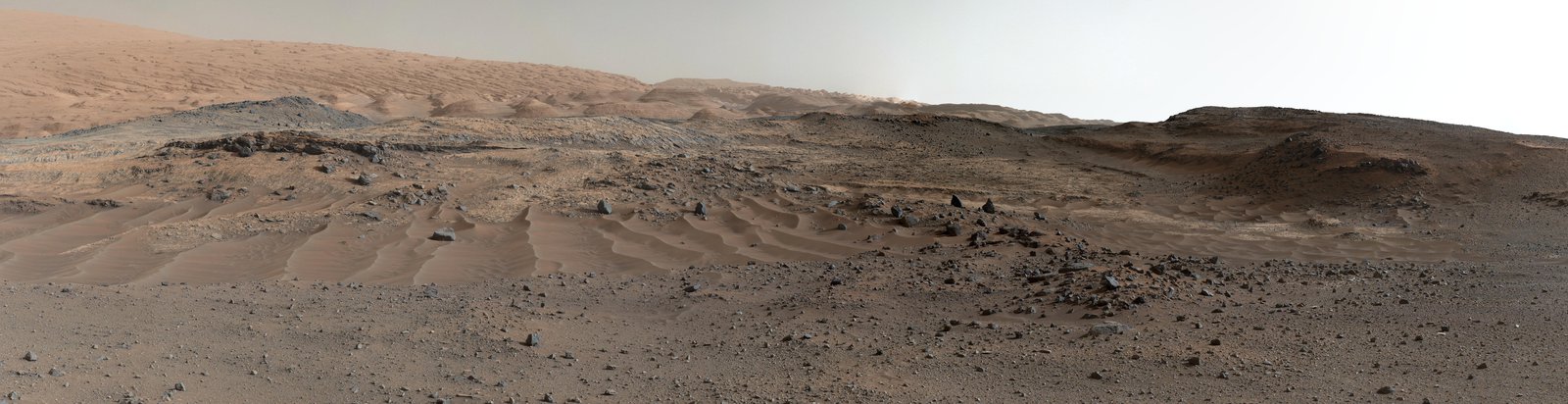
The Martian is a fascinating book by Andy Weir. It is about an astronaut who is accidentally (we hope) left behind on Mars during an emergency evacuation. What follows is a struggle for life, where science, engineering and agriculture(!) are used to keep the astronaut alive long enough to allow for a rescue attempt. There are crises and disasters. The film includes the scene where he accidentally blows up the habitat (twice) but leaves out how he gets himself in a car crash – when being the only driver on the planet! The film was made in Oman and shows a mountainous desert landscape. In the book, the habitat is instead on a boring plain, a far more likely place for a risky landing. But the scenery is brilliant and it beautifully brings a dead planet to life. Literally so when the astronaut discovers they brought potatoes with them and starts farming. But neither the book nor the film contains volcanoes. They could have learned from our Henrik.
Mars is famous for its volcanoes. (There are more things it is famous for, including some it doesn’t actually have, such as canals and three-legged blood-drinking aliens.) The supervolcanoes stand out from the planet – huge bumps on the red desert. They are different from our volcanoes: larger, older, and immovable. In some ways, Mars has a different geology from ours. It has a ‘stagnant lid’, meaning that the surface does not move – it has no plate tectonics. It also has little erosion – what formed 4 billion years ago is still there. But it has changed over the aeons. Once, this was a living planet with air and water and seas although probably without life (don’t tell NASA). More than 3 billion years ago it lost most of its atmosphere. Ever since this has been a frozen planet – frozen in time. We have never seen a volcanic eruption on Mars. But is its geology as dead as the surface implies? It turns out, almost. But not quite. Like the potato seedlings, there are small signs of life. Dying – but not dead.
Dichotomy
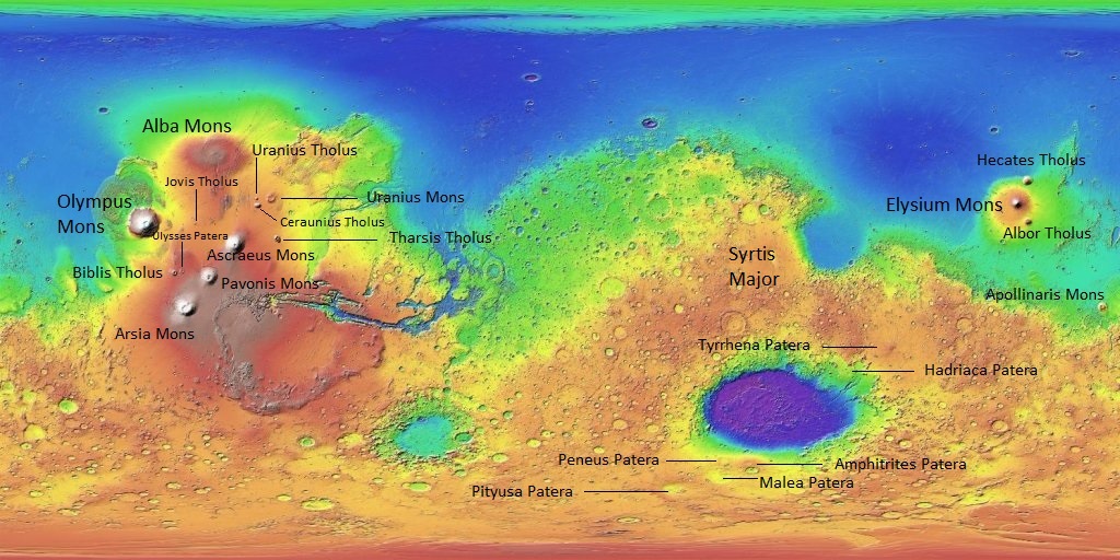
The elevation map of Mars is shown below. Blue is low, red is high. The total range in elevation is 30 kilometers, 50% more than on Earth. (It should have been three times more, due to the difference in gravity, but on Earth the oceans help carry some of the weight of the mountains and this allows them to grow higher than they should be able to.) Apart from a very deep hole in the south (the impact crater Hellas) the southern hemisphere is mostly highland and the northern hemisphere is mostly lowland, differing in elevation by 5 kilometers. Mars has a hemispheric dichotomy.
Mars elevation map. A very high resolution image can be found at https://upload.wikimedia.org/wikipedia/commons/2/2c/Mars_topography_%28MOLA_dataset%29_with_poles_HiRes.jpg or at google mars (https://www.google.com/mars/)
There are other differences. The highland is rough and cratered while the north is smooth and -dare I say- boring. The two poles look different from their henispheres, as from another world: these are the icecaps, consisting of frozen water that remains there permanently, and frozen CO2 that is permanent in the south but seasonal at the lower elevation of the north. The dichotomy continues below the surface. The crust in the south is considerably thicker than that in the north.
The borderline between the two hemispheres is clearly visible in the map. The edge of the redder colours – the highest highland – runs at an angle of about 20 degrees to the equator. This edge divides Mars about equally. North of it the land descends over a distance of about 1000 kilometers (30 degrees) until the edge of the green colours where it plummets into the lowlands. This lowland covers about 1/3rd of Mars’ surface.

Why is the north so smooth? Clearly this is a much younger surface. The reason is sedimentation or deposition: the real, much older surface is deeply covered. In places, traces of the underlying topography remain visible. On the right hand side there is a region of slightly deeper blue colours. This is Utopia Planitia, and is a sign of a massive impact crater, now deeply covered. You have seen it: this is where Viking-2 took its images, and where more recently the Chinese rover (now apparently defunct) landed. Utopia Planitia is the largest impact basin known in the solar system, more than 3000 kilometer across! It is far larger than the faint blue echo, and stretches towards the north pole: the true diameter is a quarter of Mars’ circumference. But this is all that remains visible.
There has been speculation that the northern plains once were the site of a large ocean, at a time when Mars still had a reasonable atmosphere and climate. There is no consensus on this. The ocean would have existed 3.5 billion years or more ago. This is a bit older than the current surface of the northern hemisphere which means that any telltale signs have been buried.
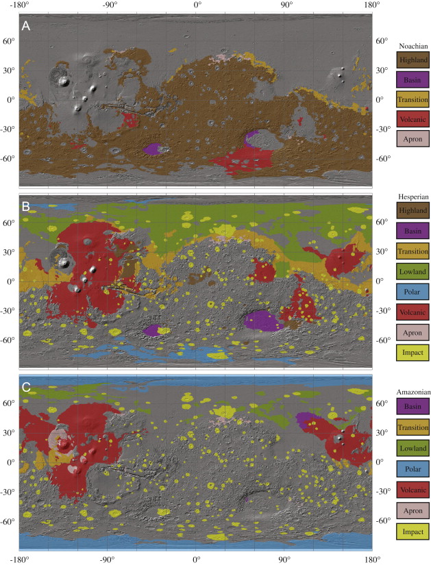
The geology of Mars is divided into three main eras: the Noachian, the Hesperian and the Amazonian. The polar caps are the youngest, late Amazonian. The lowlands are middle Amazonian to late Hesperian. The highlands are Noachian. To put ages on this (always a bit uncertain in the absence of dateable rocks), The Noachian is roughly 4.1 to 3.7 billion years ago, the Hesperian 3.7 to 3.0 billion years and the Amazonian anything younger than 3 billion years! On Mars, young means young at heart.

Source: Tanaka et al. 2016
For the northern plains, the current surface was deposited after any oceans had gone. Liquid water, in the form of lakes or floods, may still have been present. There is a lot of ice under the surface and this may at times have melted. The result was a surface as flat as the Netherlands. The formation ended perhaps 2-2.5 billion years ago. The perpetual dust storm have since covered the region in a layer of dust, regularly stirred up by dust devils.

A buried ghost crater. The dark tracks are left by dust devils. Source: JPL
There are two main models to explain the dichotomy. The first one is that there was a major impact in the northern hemisphere, creating an emormous and deep impact basin. The second model also involves a major impact (popular things, these impacts – very useful when a catastrophe is needed) but now – nonintuitively – in the southern hemisphere. That impact would have been so large that the crust melted and crystalized, lowering the density and making the crust float higher. Both models have supporters and opponents! In either case, the impact would have been early in the formation of Mars.
Volcanism
Mars is known for its massive volcanoes. Olympus Mons has the reputation of being the biggest volcano in the Solar System. In fact, it is only a sideshow of the Tharsis massif, location of four other giant volcanoes. Tharsis covers a quarter of the surface of the planet! Alba Mons is the largest (but not highest) volcano by area. Another giant is Elysium Mons. In total there are about 15 of these shield super-volcanoes on Mars. They are similar to Hawai’i, with shallow slopes, rifts, nested calderas and many individual lava flows. Not all are part of Tharsis, for instance Hadriaca Patera is a large shield volcano adjacent to the Hellas basin.
Tharsis and Elysium have wide volcanic plains on which the large shields have grown. On these plains there are also hundreds of small shield volcanoes, the smaller siblings to the supervolcanoes. There are other volcanic plains, such as Hesperia Planum near Hellas, but these small shield volcanoes are found only on Tharsis and Elysium. The volcanic plains can be compared to our flood basalts. They can be recognized as volcanic because of the presence of the oddly-called wrinkle ridges: ridges formed when the plains cooled and the solidified lava contracted. Other volcanic areas are Syrtis Major and Arabia Terra.
There are several dozen isolated volcanic massifs in the southern highlands. Apollinaris Mons is an intermediate case, lying near the boundary of the highlands The massifs further south are smaller. Pyroclastic deposits are also seen but they are less common or widespread. The equatorial Medusae Fossae Formation, along the equator between Olympus Mons and Apollinaris Mons, may be covered with layers of pyroclastics, possibly the remains of an originally more extensive layer which could from the Hesperian. Pyroclastic deposits are also seen around the Hellas basin, for instance on Hadriaca Patera. But in general, Martian eruptions have been mostly effusive and evidence for explosive volcanics is more limited.
There is an important difference between Mars and Earth, in that Mars’ gravity is much less. That has consequences for magma. Buoyancy is less and therefore magma rises slower than on Earth. This means that magma chambers can grow larger (in fact they have to, in order not to solidify over time). Larger chambers can support larger eruptions: Mars can be expected to have larger effusive eruptions than Earth, but perhaps to have done so less frequently and perhaps only a long time ago. Another difference is the thin atmosphere which allows plinian explosions to reach much higher and much further out. The lack of atmosphere also reduces the cooling rate of lava flows, and these can therefore flow for longer and further.
This of course was a long time ago. Mars has cooled more than Earth and volcanics have largely died out. But not entirely.
Evolution
The Tharsis Massif is on the Martian equator. That is not accidental. This bulge is so large that it changed the rotation axis of the planet. Just like a spinning top, Mars’ poles wandered until the heaviest piece of the planet was on the fastest spinning part – the equator. It had happened before. When the dichotomy formed, the planet began to spin such that the equator divided the two hemispheres. Nowadays, that division runs at an angle of 20 degrees to the equator, as seen from the curve of the edge of the orange region. It is Tharsis’ fault. It also shows that this volcano formed when the dichotomy was already established – which is not a surprise.
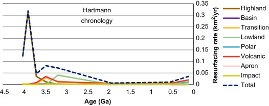
When did the volcanoes form? Even though we mainly recognize the large volcanoes, there is plenty of evidence for eruptions elsewhere. Mars is a highly volcanic planet. But the visible volcanics is not uniformly distributed. There is less in the southern highland, and also little is visible in the northern plains. Volcanic evidence is mainly seen in the region in between. Elsewhere, much may be buried below the surface.
The plot shows the ages of volcanism. Red shows the volcanic regions of the Noachian, the Hesperian and the Amazonian. The oldest volcanics are around major impact craters such as Hellas. Later volcanics became dominated by Tharsis and the area around it, with the Elysium region as another main site.
If this gives the impression that Martian volcanoes are recent, remember how old even the Amazonian is, at 3 billion years! Look at rate of volcanic resurfacing, and it shows that is was highest 3.5 billion years ago. There seems to have been a recent uptick: that could be an artefact because over the past several billion years, volcanic activity has been in the same general regions. The older flows have been buried by newer ones in the same place and are now hidden. Before 3 billion years, volcanoes were active in many more regions.
But apart from the obvious (or less obvious) volcanoes, in fact almost all the surface of Mars has a volcanic origin. It is basalt with pyroxene and plagioclase, sometimes with a covering of pyroclastics. The dust storms in The Martian are also basaltic, heavy hitting. The Mars rovers have even found that the presumed sedimentary deposits inside craters which they were send to study may also in reality be volcanic. There is little relation of the basaltic surface to the known volcanoes, apart from Syrtis Major and the volcanic regions around Hellas. Instead the Mars-wide basalt is ancient: it dates from how the crust was made. Think of our own oceanic crust, and imagine what it would look like without mid-oceanic ridges and subduction.
The magma production rate is of course hard to measure. Based on the bulges and surface flows across Mars, a rate of 0.17 km3/yr has been estimated as an average over the past 3 billion years. On Earth, it is a much more impressive 30 km3/yr. That means all of Mars combined was only about as productive as Hawai’i. The rate has declined further over time.
Making the crust
Volcanic activity can be difficult to make if the crust is too thick for the magma to break through. Estimates for Mars’ crust have ranged from 50 to 110 km; the latter would be volcanically prohibitive. That situation has improved. The Insight seismograph has allowed us to directly measure the crustal thickness, using time delay from waves reflected of the bottom of the crust. That suggests a local thickness of no more than 20 or 40 km. (They see two reflections and ione can argue which is the real true Martian Moho.) Their model for Mars as a whole is shown below. Shown is the thin-crust model; the second option is the 40-km thick-crust model. In either case, the crust is not as thick as had been expected. The crust will be thicker in the highlands is expected, because this is what causes the highlands to rise up: they float higher on the denser mantle.
As an aside, either model requires a high mount of radioactivity in Mars’ crust and lithosphere to provide sufficient heat. Much of the radioactive elements in the original mantle have ended up in or just below the crust.
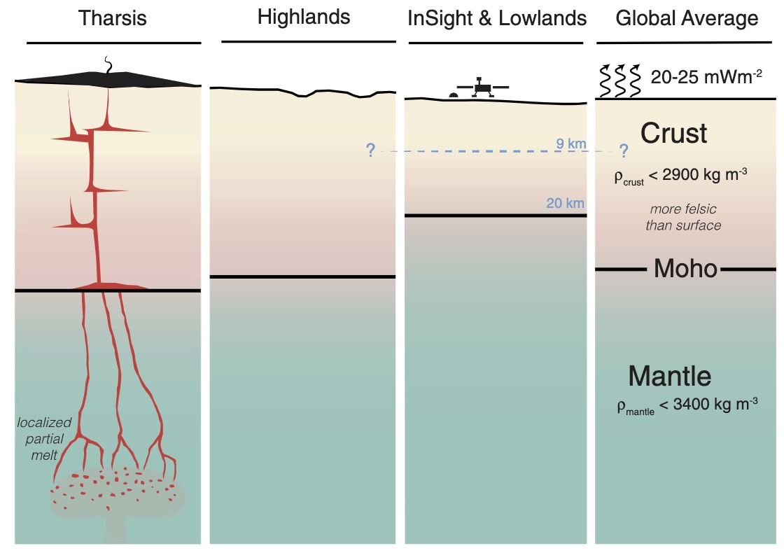
Source: Knapmeyer-Endrun et al. 2021
The crust formed from the magma ocean which covered Mars just after its formation. The top of the magma solidified and became the 20-40km thick crust. There have been impacts and erosion which shaped the planet. But the building blocks are magma.
Plumes of Tharsis and Elysium
There are two main volcanic provinces on Mars: Tharsis and Elysium. Although the second largest volcanic province on Mars, Elysium is minute compared to number 1. Tharsis contains a volume of 300 million cubic kilometer. Elysium is only 1% of that: 3.5 million cubic kilometer. It consists of two parts: the mountain and the plains. It turns out the two are not directly related. The mountain is old. The plains are young – very young.
Tharsis and Elysium have in common that volcanism continued for a billion years or more, in the same location, for 10 times longer than plumes survive on Earth.
Both regions are located near the boundary of the highlands and northern plains. It seems plausible that this is related to the stability of these plumes. Four of the main volcanic regions (Tharsis, Elysium, Syrtis Major, and West Arabia Terra), are 90 degrees in longitude apart and are all in the transition region of the dichotomy. But they are widely different in activity, with Tharsis being by far the strongest and longest lasting. The three mountains on the central Tharsis bulge are exactly in a line. That is not due to a migrating plume or a moving crust, as all three are of similar age. Instead the bulge was so large that it cracked the crust forming an enormous, and straight, fissure. There are a few other cases of volcanic alignments on Mars, but nothing as prominent as this.
Elysium consists of two distinct regions: there is the big one, Elysium Mons (and its small sidekicks, Hecates Tholus and Albus Tholus), and the flat one, Elysium Planitia. The mountain is almost entirely old. The central caldera is 3 billion years old, based on crater counts. There are a few younger (amazonian) flows on the slopes but these are minor. The volcanic plain is offset to the side, and here the young flows are in an extended region well away from Elysium Mons. They are separate volcanic features.

Source: Grott et al. 2012
The plot shows the ages as derived from the density of craters on each of the volcanoes and volcanic regions. Elysium Mons shows up as ending its activity 1 billion years ago, among the first of the large volcanoes to die. In contrast, the caldera floors in Tharsis are as young as 200 million years. The Elysium Planitia, the volcanic plain, is dated to 200 million years and less, with activity continuing into the very recent past. If any volcanoes on Mars are still alive, this is where to look. Don’t go for the big mountain. Look at the fields of lava.
Marsquakes
The Insight lander brought a sensitive seismograph to Mars. Before Insight, Viking-1 had detected a single marsquake. It was hoped (and expected) that Insight would do better. The predictions weren’t too precise: Insight was expected to detect between 1.5 and 190,000 earthquakes per year. (Yes, you read that right.)
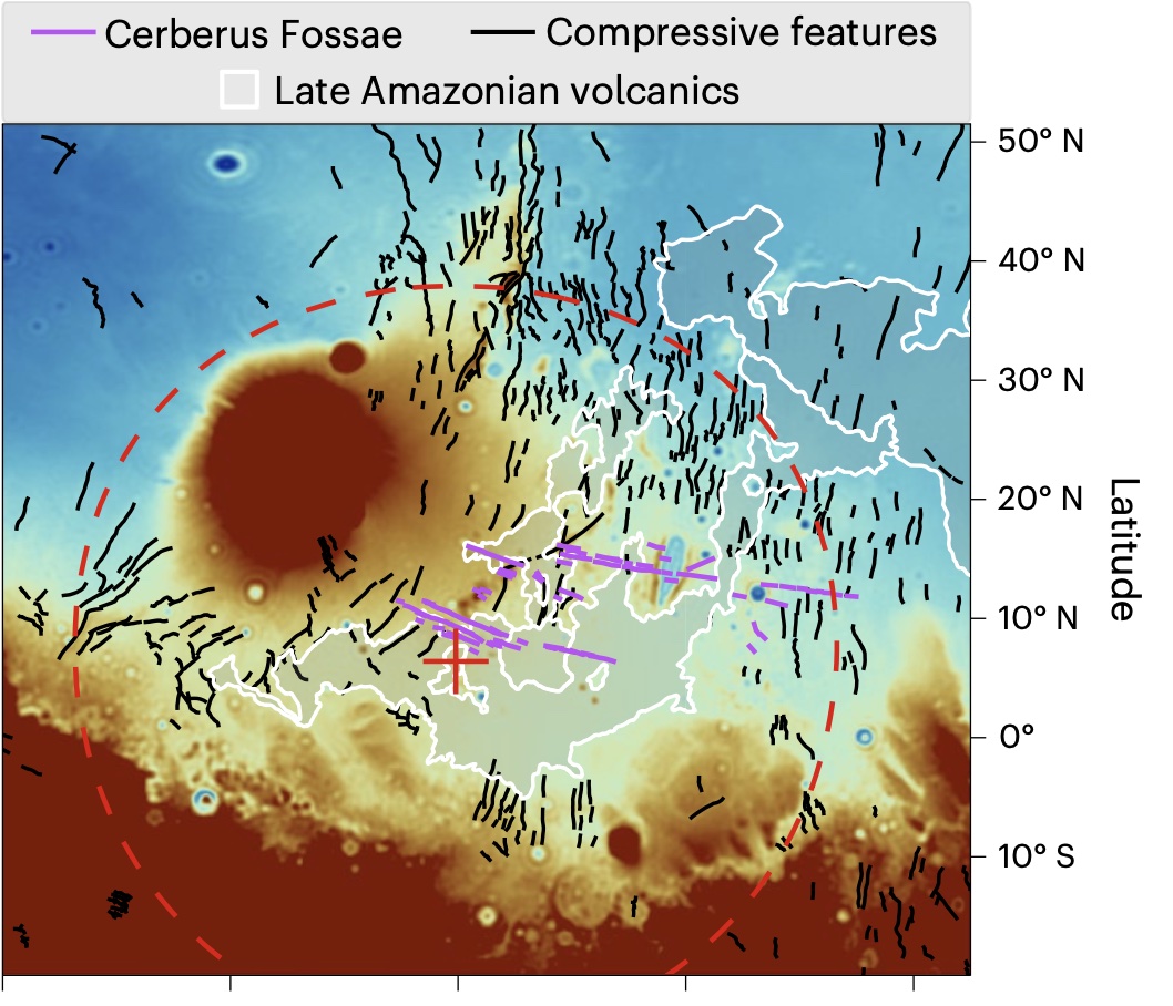
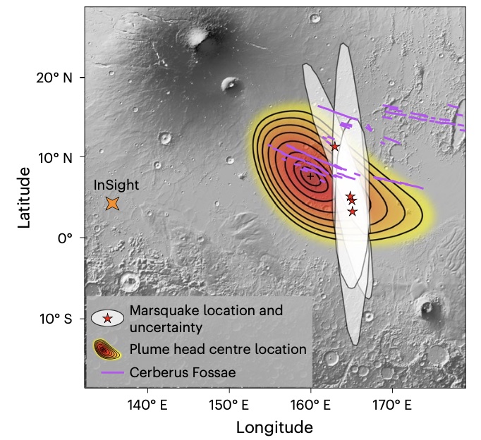
The predictions were correct, in all their imprecision. More than 1000 quakes were detected, or several hundred per year. The three strongest ranged from M4.2 to M4.7, decent shakes. The strongest was detected in May last year and was initially classified as M5, later reduced to 4.7. Insight was put down close to Elysium Mons. This showed insight, as it turns out that the main source of earthquakes on Mars is from the adjacent Elysium Planitia. To be precise, it is from the region at the centre of the plain called Cerberus Fossae. Two of the three largest quakes came from here (but not the largest one), and some long-period events were also detected which are interpreted as evidence for deep magma flow.

Adapted from Jacob et al., Tectonophysics, Volume 837, 229434 (2022). The shapes and dots show the location and uncertainties of the stronger detected marsquakes. Purple events are less accurate. The red star and oval have been added to show the M4.7 detected in May 2022, the largest known marsquake.
The marsquakes on the plot are scattered along a north-south direction around the location of Cerberus Fossae. The ovals show the uncertainty in the position, also directed north-south. (The distance of a marsquake to Insight is typically better known than the direction from there.) That the points scatter symmetrically around Cerberus Fossae suggests that the marsquakes come from that graben system. In a recent study, 18 of 24 detected low-frequency marsquakes are from there, at a depth of 15 to 50 km. These type of quakes come from warmer rocks: this area appears to be the main location of heated rock on the Mars of the Martian. It is a pity the astronaut wasn’t left behind there. High frequency events are harder to locate, but again the majority are from the same general region, now at a depth of a few kilometers and caused by normal faulting. Half the total seismic energy generated by Mars come from this small region! What is so special about this location?
Cerberus Fossae is a graben/fissure system which cuts across the centre of Elysium Planitia. It is 1200 km long and as much as 500 meter deep. Cratering shows that it is younger than 20 million years – for Mars, that is extremely young. The graben cuts across mountains and outflow valleys and is therefore younger than either. The floor of the valley may in places be as young as 2 million years and some lava flows in the region could be even younger. At the bottom of the valley are boulders which appear to have fallen from the sides, with sizes ranging from 1 to 10 meters. They come in groups which can be tens of kilometers wide, and are sometimes so recent that the trails where they rolled across the floor over kilometers are still visible. The rockfalls may have come from marsquakes much stronger than what Insight has detected. These quakes could have been as strong as M6 or even M7, depending on whether there was one large of a lot of smaller quakes. Could the Martian have survived such a shake?
There is more. There is a 17-km long section of the Cerberus Fossae where the surrounding area seems to have been blanketed by a dark deposit. The deposit extends northeast and southwest of the fissure, where the extend seems to be affected by the wind. There also is wind-blown sand around the fissure but that was clearly blown in. In contrast, the dark material came from the fissure itself: it was a fissure eruption.
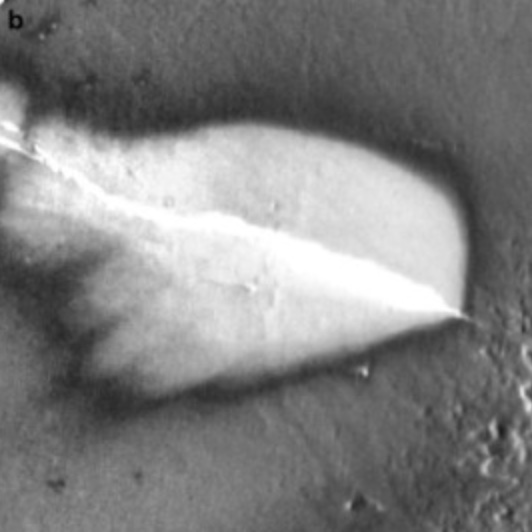
Infrared image where the blanketed region is bright because the dark material warms up faster during the Martian day. Source: Horvath et al (2021)
There are some small (1-10 meter) craters within the region of the blanket. In some cases, these craters are covered by the dark deposit. In others, the craters are much brighter. In the latter case, the crater is thought to have formed after the dark material was deposited, and made a hole that uncovered the brighter material below. This can be used to measure the thickness of the blanket: it is between 10 and 40 cm. The total ejecta volume is about 0.02 km3. This makes it a VEI-3.
When did this eruption happen? Crater counts on those craters which post-date the eruption give an approximate age. This is between 50,000 and 200,000 years. In Martian terms, it happened almost yesterday.
This small fissure is probably the most recent volcanic eruption on Mars. Whether any lava made it out of the fissure is not clear: it might be covered by the deposit. This was only a small fissure fire, although the ash traveled further than it would have on Earth due to the little atmosphere. It is possible that there was a phreato-magmatic aspect: the rising magma may have encountered subsurface ice. That would probably be quite common on Mars.
It turns out, the location of this eruption agrees well with that of the marsquakes. It seems this region remains active. Magma is moving and it seems to be present not far below the surface. Perhaps in another 100,000 years, we will have another minor eruption. Such is Life on Mars. It is life in the slow lane.
The plume
Where there is smoke, there is fire. Something is melting the mantle (or rather the lithosphere) and thus provided the heat that started the fire that made the smoke. It was something new. In fact, Elysium Planitia is the only place on Mars where the volcanics started only recently (meaning, more recent than 3 billion years ago!). Everywhere else, including Elysium Mons, eruptions started several billion years ago. This place is special.
Elysium Planitia gives the appearance of a (smallish) flood basalt. The elevation map shows that Elysium Planitia is raised above the level of the northern plains: it has formed a bulge, 3000 kilometers across and 1 to 2 kilometers high. The bulge overlaps a bit with the dichotomy to the south and with Elysium Mons to the northwest, which both hide a part. There are ghost craters here, covered by lava flows. They show that the lava flows are no more than some 100 meters thick. Therefore, the bulge was pushed up from below, and not formed by the outpouring of lava. The size, appearance and uplift are typical for a plume head.
Source: Broquet & J. C. Andrews-Hanna (2023)
A recent model (based on gravity measurements) is shown in the figure. The circle gives the size of the plume head and the red plus sign is the centre. The white outline shows the more recent lava flows. The compressional ridges (or wrinkle ridges) are caused by cooling: these are common on Mars.
In the models, the plume is 100-200 K warmer than the surrounding mantle and is flattened against the lithosphere. When did this plume form? Again, craters give a clue. Large craters on the slopes of the bulge have the same slope in their crater floors. When formed, these floors would have been flat. Therefore, the bulge formed after the craters and the craters were uplifted and tilted. It is a young feature, no more than 350 million years old. This age fits with the maximum age of 200 million years from the lava flows.
The plume is not as vigorous as plumes were in the olden days of Mars. The lava flows, including this extending into the northern plains, have a volume of up to 0.3 million km3, which is small in comparison to say Hesperia Planum which is 3 or 4 times larger. The eruption rate is also low: 0.001 to 0.002 km3 per year, although it may have been higher during the two eruption peaks 125 million years and 30 million years ago.
Why did this plume form so late, a long time after any other activity? That is impossible to say. There is no very large impact crater known younger than some 3 billion years, so it unlikely to be caused by an impact. The plume is centred on the Martian equator, and is midway on the equator between Tharsis on one side and the northern reaches of the highlands: it is in the middle of the lowland on the equator. That points at a structural reason: the location on the equator suggests that Mars’ rotation helped, and the lowland location points at the need for a lower pressure on the mantle below. We have of course no idea about the depth of the plume. But it seems ths plume may have needed all the help it could get. The mantle of Mars is likely more viscous than ours, and therefor plumes rise slower and more reluctantly. This may have delayed the rise, but also made the feature longer-lasting than Earthly plumes.
How about the relation of the plume to the recent volcanism? That is clearer. The centroid of the plume falls at the centre of the Cerberus Fossae, and is only about 200 km from the most likely location of the marsquakes. It is all connected.
The models suggests that the plume would have formed magma chambers and dikes. The stress calculations show that dikes can originate from some 50 km deep, and migrate upwards to some 2 km depth where the strength of the overlying rock becomes a factor. Dikes can range in thickness from 3 to 45 meters. When approaching the surface, they cause extension. This explains the graben of Cerberus Fossae. In general, the region of Elysium Planitia shows contraction (and wrinkle ridges) due to Mars’ slow cooling. In the Cerberus Fossae this contraction recently became extension – unusual on Mars. That suggests the presence of shallow dikes below the surface.
In fact, the Insight marsquakes support this view. It found quakes at some 15-50 km depth with moving magma, and tectonic events at a few kilometers. The first would trace the magma rising in dikes from the plume, and the second the pressure from the top of the dike(s). The youngest eruption could come from a minor dike (minimum width) and perhaps that is all the plume remains capable of. Don’t expect too much.
Or perhaps Mars could still surprise us.
Mars was dead, to begin with. But it has decided to come back to life. As dinosaurs began to develop on Earth, Mars formed its first new plume for 3 billion years. What we are seeing is this final flush of activity, a small reprisal of the playground of its youth. We are lucky to see Mars now, so that we can imagine what the past was like.
The Martian brought a dead planet to life by growing potatoes. Mars responded by growing volcanoes.
Albert, March 2023

References
David Horvath et al.: Evidence for geologically recent explosive volcanism in Elysium Planitia, Mars. Icarus, Volume 365, 114499 (2021)
Taichi Kawamura et al: S1222a – the largest Marsquake detected by InSight. Geophysical Research Letters, in press (2023)
Brigitte Knapmeyer-Endrun: Thickness and structure of the martian crust from InSight seismic data. Science, Volume 373, page 438-443 (2021)
K. Tanaka: The digital global geologic map of Mars. Planetary and Space Science, Volume 95, Pages 11-24 (2014)
A. Broquet & J. C. Andrews-Hanna: Geophysical evidence for an active mantle plume underneath Elysium Planitia on Mars. Nature Astronomy, Volume 7, pages 160-169 (2023)
A. Jacob et al.: Seismic sources of InSight marsquakes and seismotectonic context of Elysium Planitia, Mars. Tectonophysics, Volume 837, 229434 (2022)
M. Grott et al.: Long-Term Evolution of the Martian Crust-Mantle System. Space Science Reviews volume 174, pages 49–111 (2013)


_with_poles_HiRes.jpg)
https://assets3.thrillist.com/v1/image/2948692/size/tl-gif_overlay.jpeg
Thank you Albert, it makes sense that Mars is not completely dead yet, as its between Earth and the Moon in size, so cooling rate should be too, not as dead as the smaller moon, not as active as the larger earth. Mars been geologicaly active for most of its history, and its only in the last 2 billion years that volcanism have begin to slow. But indeed Athabasca valles haves amazingly fresh lava flows if you use the CTX imagery mosaic in Google Mars mode. Mars is still active, but clearly in its last gasps, in another 1,5 billion years Mars will have cooled perhaps too much to stop volcanism. Martial litopshere is already 500 km thick or more as Insight measured, but thinner parts ar cereburs fossae probaly exist. But yes future eruptions are a possibility
How deep the astenosphere is is what determine how much volcanism there is, as an astenosphere is above its melting point but keept quite solid under pressure, on Mars its about 500 kilometers down and there its perhaps too high pressure to allow much melt formation, but likley there is thinner areas at Elysieum. Mars have cooled more than earth so its litosphere is much thicker
Athabasca Valles have insanely young flows thats for soure, some of them Maybe pliocene or even Pleistocene in Age.
And the ash deposit is probaly latest pleistocene
Is there any geothermal vents on Mars? If there is shallow magma there should be .. But No sulfur have been detected in the Marsian Atmosphere
Athabasca valley is an outflow channel and may have had flowing water rather than lava. The idea is that an eruption upstream melted subsurface ice
Well, it came out of a fissure in the ground in a volcanic province, and it has textures of rough aa lava and smooth pahoehoe lava, so that alone shows it’s probably lava.
Still not convinced? There are small impact craters all over the place, seemingly secondary craters of some larger impact because they happen in clusters, where they impact the outflow channel and the surrounding areas of broken up plates and lava-resembling textures, they scatter an intensely black dust, of the same colour as the (probably windblown) material on the sides of the fissure system. We know basalt is black, and as far as I know, water would be white. Anyone can go to Google Earth, to JMARS, or to ArcGIS and check these things.
I was reading papers that mentioned fluids of undertermined type — i.e. lava or mud. I don’t know the most recent state but on earth the two frequently go together and mud reaches further than lava! But they may have been talking about the original formation of the Athabasca. There has certainly been extensive lava flows in the region over the past 100 million years
Clearly is lava flow features with tumulus pahoehoe and inflated crusts, and lots of pesudocones where lava flowed over volatile substrate
Ionian flood lavas too coud produce that when fast moving basaltic lava flows on IO flows over deep layers of sulfur snow, sadely Galileo photos have only closeups of Ionian pahoehoe flow fields rather than the fast flood lavas like Pillan 1997 ( only one super closeup of that )
Lava have low heat conductivity and is amazing at stooring heat, that means it can flow for wast distances, huge floods basalts probaly can flow thousands of km If effusion rates are high enough, and some insulated slow pahoehoe flows in Deccan Traps are 1500 km long
Because lava insulates well and keeps it heat well its No problem of flowing wast distances, there are submarine lava flows that are 10 s of km long and probaly 100 s for Ontong Java Plateau
On Mars with less atmospheric cooling by convection lava woud flow even further than on Earth, But because lava is so good insulator, I dont think it matter so much the outside enviroment
Mars have a supprisingly large low density core that are mostly liquid, lots of more volatile sulfurius elements where sucked in in colder parts of the solar disk and acts as flux allowing it to be liquid today, lack of convection is why there is no magnetic field since its not hot enough…
It coud it be that Mars core is cooling too slowly for convection now ? How hot is the center of Mars? Earth is around 6000 C so I usualy think that Mars center is perhaps 3000 C
Mars is quite big woud not supprise if the interior is suprisingly hot, althrough not as hot as Earth
Now imagine a Super Earth with 7 earth masses… how very hot that interior will be
But I dont share the late Henriks opinions that Mars is stone dead, and stone cold inside, its Impossible for something as massive as Mars To have cooled yet, and InSight confirmed a liquid core
Wonderful! A article about Mars volcanoes, and mentioning The Martian, as well!
Kudos to Albert. Very interesting.
Albert, thanks for sharing this scientific information about Mars with us. I’m thinking we have a better chance of cooling Venus than we have of making Mars habitable.
Regarding Earth, I’m sad about the end of Dilbert. However, there are options. A brief history of our planet: https://xkcd.com/1732/
Maybe long term, but Mars is not necessarily less habitable than the south pole base which we have occupied now for decades. It is the distance that makes it too extreme but the environment is within our capabilities to conquer, the atmosphere once compressed would be suitable for plants, there is abundant water in ice, and also a lot kf oxygen as perchlorate in the ground, which can also be used as a rocket propellant. Venus will be better in the end, stable atmosphere and strong gravity, but it is impossible to do anything with it until it is cooled down, a couple centuries to be very optimistic. I dont think the cloud city is viable, at least it is much harder to execute than a Mars landing.
At least the plan with Starship is that the rocket itself will be the habitat until local construction is possible. It makes sense, it has to handle the trip to Mars, actually sitting on the planet is a breeze by comparison. And skips making an expensive dedicated lander. The abundance of electric cars available will make transport a non issue at least provuded a power system is set up. I think the cybertruck was designed with Mars in mind personally. EVs should have enormous range on Mars too, way over 1000 km easily in the low gravity and thin atmosphere.
A venus floating colony woud be terrfying, looking down on a searingly hot murky abyss, not that diffrent from a gas giant because you can never surivive the hotter depths. Quite easy to float in Venus high density cO2 atmosphere an earthlike mix woud work and outside you only needs an oxygen mask.
In Venus upper atmosphere you woud have blue dayskies because of raylenght scattering, the venusian clouds are very extensive but also kind of very diffuse knowing the data from venus atmosphere missions, so its more like a thin haze, visibility inside Venusian clouds are over 9 km so not at all like Earths thick water clouds where visibility can be under 10 m.
But a large venus colony coud also be a Beautful sight, with sunny skies and pastell colors, Images of Bespin comes to mind, woud like to have an apartment in the sunny skies
Jupiter is harder probaly Impossible with its high entry speeds, and high 2,5 G gravity, hydrogen mining there will be Done by robots or nothing at all, hydrogen being the ligthest gas, the only thing that woud be bouyant in Jupiters atmosphere is hot hydrogen or massive ultra pure hydrogen blimps, But floating in Jupiters troposphere is probaly almost Impossible, only hot hydrogen woud work, the high entry speeds makes it leathal to try To enter Jupiter as well and then there is the awful radiation above the planet, with its very high gravity and the very light nature of hydrogen air planes work poorly on Jupiter unless you are deep down, But there its over 100 C
Here is a concept for a venus Zeppelin mission https://m.youtube.com/watch?v=0az7DEwG68A
Would be interesting to calculate the energy density of oxygen in a hydrogen atmosphere. Hydrocarbons have no energy density really, only because of our atmosphere being a large part oxygen. The energy density of such compounds is about 40 MJ/kg. H2 is about 3x this but 1 kg of H2 takes up a very large volume compared to 1 kg of CH4 or similar. But Jupiter has unlimited H2.
O2 has a density of over 1, denser than water, in the liquid stage, it is a lot denser than any hydrocarbon that can be made liquid without heating over the flash point, so a lot of oxygen can be stored in a given space than the same volume of CH4 etc. The O2 molecule also contains most of the potential energy that is released when combusting things in it. I imagine a plane on Jupiter would be able to fly for much further than any plane on Earth could, probably capable of a distance that could circumnavigate our planet. But such a distance on Jupiter would be barely enough to explore the Great Red Spot… Maybe a reverse fuel cell and propeller, might double the distance, even better if the vehicle has a positive glide ratio like the U2, might be able to explore the spot properly or even indefinitely if it can ride the thermals 🙂
I would strongly suggest not to fly through the red spot. Thermnals would be the least of your worries. It is red for a reason, in my opinion.
Not through it, around it, catching some rising air to regain altitude. But at worst I have seen the spot is red from red phosphorus, which is very flammable but not that toxic (compared to white phosphorus at least)? Although with so much hudrogen aby element might only exist as its hydride and phosphine is pretty dangerous.
Is the Spot actually some sort of gas giant equivalent of a mantle plume, with high temperatures and exotic chemistry for the surface layers?
Life on Earth uses red as a warning sign: approach and blood will flow.. it seems appropriate for a category-6 hurricane. Perhaps Floridians would be maore cautious about hurricanes if they were coloured red.
The red spot is supposedly a cold-core anti-cyclone. And is doesn’t extend that deep, perhaps no more than 200 km. Given that Jupiter’s radius is ten times that of the Earth, that is a 20-km deep storm on Earth. A comparison to a hurricane (albeit anti-cyclonic) seems warranted.
The data from Juno has a depth of at least 300 km and as much as 500 km depth for the spot as of 2021, which is still maybe not a lot for the size of Jupiter but is equivalent to a 50 km tall storm here, which isnt a thing. As powerful as they are I dont think a hurricane is comparable to the Spot even factoring scaling, there isnt really anything like it on our planet, or on any of the others for that matter.
Comparing the speed of the winds in the red spot with those of a category-5 hurricane, and for the pressure of around 0.5 atmosphere of the cloud layer, you find that the pressure force from the winds is 5 times larger than that of the hurricane. So it is stronger, but not that far off from what we find on Earth. Of course the physical scale is much larger.
The red is not red hot its toxic chemicals right ?
But the Red Spot is defentivly searingly hot at depth being an atmospheric mantle plume.
The top clouds of Great Red Spot is probaly very cold because it sit close at the 0,1 bar level
Personally I think a balloon is the answer.
The problem is getting it there which requires dissipating rather a lot of kinetic and gravitational energy.
Once there, with sufficiently large solar arrays, it should be possible to examine jupiterian life ….
Your winged glider needs to be travelling fast to have lift and have huge and thin wings. Below the water cloud layer it woud probaly work very well with higher hydrogen density there, But in the 0,5 bar ammonia cloud tops it Will be difficult to fly in light hydrogen and high gravity
Amazing that jovian thunderstorms can lift basketboll sized ammonia – water slushballs all way up to the 1 bars pressure before they rain out and vaporize in the depths
So updrafts coud be helpful But anything less than 13 Bars on Jupiter is a medium density less than atmospheric pressure on Earth
Its deep … Juno Data suggest Jupiters wind features going down around 3000 km or more, so a soure sign its powered by internal heat, the Great Red Spot is probaly an atmospheric volcano feeding from rising heat
The old days where Jupiters circulation was tought to be as shallow as oil film on water is gone
Thunderstorms as tall as
100 kilometers are not uncommon on Jupiter Thats about the distance from the water cloud layer at 5 bars to the tropospause at 0,1 bar
You see them as bright clumpy dense clouds in Juno images a soure sign of convection
You needs to be pretty deep in Jupiters atmosphere to fly a plane, at around 13 Bars pressure the hydrogen gas because as dense as Earths atmosphere. But there its also around 60 C I think. This is below 3 layers of cloud systems stacked 100 km above you so it woud probaly be quite dark, If not nearly pitch black, quite terrfying
With supersonic flight you Maybe able to fly in the – 70 c around 2 bars pressure ammonia sulfur cloud layer and there it woud be much brigther perhaps like an light overcast day on Earth with sunlight filtering down from the ammonia cirrus above
I wonder so much what this woud look like 🙂 and some areas on the 2 bar level have No clouds above so are sunny with blue skies. In the distance huge water Cumulunimbus push fuzzy anvils all way up to the 0,1 bar level the tropospause..
What woud it look like? Woud the clouds look like Earths? The Jovian Cumulunimbus does look like Earth thick by looking at Juno Imagery bright clumpy clouds with shadows
Flying in Jupiters Tropospause woud be almost impossible 0,1 bars is much much less density than Earths at same pressure, But hypersonic may work there
Woud be a spectacular sight with dark blue skies, and high streamers of ammonia cirrus and Ice halos around the sun, brutaly cold at – 160 c
The galileo Atmospheric probe deployed its drouge and main parachutes at 0,01 bar level at high speeds
Ever since a small kid I have wanted to roam the jovian skies and the surface of IO
The cold on Mars is an alien cold, because the atmosphere is so thin and dont conduct heat as fast as well
So – 120 C may feel like – 18 C because the atmosphere is so thin
Marsian habitats may not need more insulation than Northen homes at Earth
Then there is the nightmares of Titan with 1,5 Earth atmospheres and – minus 180c that will rob your body of heat much faster than Antartica will. Titanian habitats and suits will have to be very insulated
pretty accurate!
Mars have very thin air pressure, yet very coloured skies beacuse of mie scattering of dust
Woud Mars have black dayskies without dust at only 1/100 th of Earths surface pressure?
Is there any chance that Olympus Mons still have an active magma chamber?
There is likely magma somewhere in the system. But the plume I think has died. A mantle flow from Tharsis towards Olympus Mons would see the pressure reduce when it gets away from the Thasis bulge, and this could cause some decompression melt. But any magma production will be very small.
M4.1 near Herdubreid. A 3.4 yesterday. The lake inside the Askja caldera has melted for the most part. Activity is increasing in this area.
So far only plutonism/intrusion. In itself already intersting with rising geothermal heat in Askja’s groundwater system. On what depth do phreatic explosions (Maar eruptions) occur? I guess that this is the worst and most unpredictable risk.
And one of the last images from Insight.
https://mars.nasa.gov/resources/27209/one-of-insights-last-images/
Get the helicopter to fly over and blow off the dust! It needs a spring clean
Woud be fun to fly that helicopter on Jupiter at the 0,01 bars level ( same pressure on Mars ) But hydrogen is so insanely much ligther than what cO2 is so, Maybe not possible for it to fly at all in Jupiters Stratosphere
But it coud easly fly deeper down in the highest cloud layer and below that it becomes increasingly easy for anything to fly
A few 1000 kilometers below the water clouds you coud perhaps swim But temperatures reach many 1000 s of degrees C there
Giant giant Zeppelins woud also work on Mars I think, But needs to be huge in the thin Marsian Atmosphere
Thank for your impressive introduction to the world of Mars Volcanoes, Albert!
In my view the volcanism on earth is as unique in the universe as the life on it. Each planet has its certain “personality” or fingermark of physics and chemistry for geological dynamics. Also the distance from sun matters. And the size of the sun. A dwarf sun or giant sun would make the plants look much different.
Mars is a lot shaped by its size. It is smaller, has less gravity than earth. It has difficulties to keep gas and water in the atmosphere. The size blocks any mantle circulation and plate tectonics. Question is: What is the Core of Mars? How different does it look to Earth and what impact does it have on the Mantle?
Volcanism on Mars looks similar to Earth’s Hotspot volcanism, but without plate movement above. Imagine the Pacific plate without movement, since this Hotspot was born. The whole chain from Big Island to Kamtchatka would accumulate on one spot.
Scientist have a bad habit of assuming something is extinct just because they don’t see any activity. Just because you don’t see any activity doesn’t mean it isn’t there. If you had wrote an article like this 30 years ago, you’d probably disrespect by some of your peers.
I noticed this the other week but there seems to be some sort of earthquake swarm that’s been occuring on and off around 5km below the NNW slope of Erciyes Dağ in Turkey, there was a M4.7 and M4.4 there today.
It’s a bit out of the way of the 2 faults where the M7+ earthquakes occured.
I doubt it’s related to any volcanic activity, Large earthquakes can stress local faults in the area causing earthquakes, not on the same fault line. I’d raise my brow if we start to see some deformation.
What’s going on at Grimsvotn? Inflation and Seismic moment have all surpassed the last 3 eruptions. So where is the eruption? Where’s the noisy build-up. I demand a 12 km3+ lava eruption this summer! Chiles-Cerro Negro de mayasquer producing some more LP quakes so another major swarm is possible this year. So many restless and cheeky volcanoes
Is a local fault reacting to stress release from the 7+’s?
Still can get some pretty Martian Skies 🙂
https://astrodon.social/@MaryMcIntyreAstro/109978500197324735
beautyful! amazing to see that color and shades in an atmosphere thats as thin as Mars… something you often only acossiate with dense humid atmospheres….
Shallow earthquake swarm under Tanaga volcano (Aleutians). Warning level raised, albeit only to ‘yellow’
Both Tanaga and Takawangha restless together… related? That’s now 9 US volcanoes at elevated alerts!
By the way, Kilauea has paused.
Anybody know where the deformation data for these volcanoes are? I am getting interested.
Katla has 2 stars and Grimsvotn is getting a little noisy. 🙂 Enough boring modest-sized effusive eruptions bring on the awesome explosive eruptions!
CCN is having an earthquake spike too! I am losing it. right now!
Do you know where you can view Chiles Cerro Negro earthquakes. Is there a website? I usually see the bigger ones there but can’t get much info on the smaller quakes.
@Chacanger: It took me a while to find it, but for Chiles-Cerro Negro you can find a drumplot here: https://www.igepn.edu.ec/ccn-sismogramas
There were more than 8400 tremors in the last day!
To me there are two potential causes for this swarm. One is that another plume of buoyant magma is causes extra stress or the plug is beginning to weaken. This spike came almost out of nowhere, some LPs preceded the main swarm but that was just a few days ago. We’ll need to wait for the deformation data but my non-expert observations of the seismographs makes me think that there is a hell of a lot more small earth quakes than before and that they’re happening between Cerro negro and Chiles with not as many towards the SW at Potrerillos.
Before I get too excited about the twins in Alaska, I would love to see some deformation data.
@Alberto, thanks, was looking for that for ages.
A bit of an unprofessional video but this is the best example of a phreatic explosion I have ever seen. Lava interacting explosively with water. caveat is this is not on a volcano 🙂
https://youtu.be/RAIoxfn2Af4
And another, low quality but pretty straight to the point
https://youtu.be/dYObrz5bF9Q
This is what I imagine the lava that is found deep in the interior of Kilauea and Bardarbunga is like, at 1300 C down where the 2018 crustals were formed.
It might also be what some of the lava erupting on Io is like right now. Doesnt matter whether it is basalt or komatiite there are no silica polymer chains at 1300 C unless it is nearly pure SiO2. Composition of Io that is known from its density would suggest the lava is probably basalt, like the Moon.
https://m.youtube.com/watch?v=ykrlKI6Gxgg
Wow your videos are scary, indeed steam expands alot
Yes Ionian lava may look like liquid iron slag ..its hot enough, 1280 to 1350 C is a common accepted revised figure for Galileo temperature measurements, Maybe higher in some, But its was far away from the Moon when it Did that and lava cools Once exposed to vaccum even If its slowly, But thermal resolution data is very low and pixelated for IO even If the Galileo probe got some very good closeups of some calderas
Entirely possible it Maybe up to
1500 C looking like liquid iron flowing out, when better thermal measurements are made
Im so excited for the winter 2024 close Juno probe flybys, Hopes it gets good shots and gets really close
Io is indeed my favorite object in the solar system, the spectacular sight of kilometers high lava fountains roaring out on the nightside feeding a large ionized gas plume and Jupiter looms large in the sky horizon. And there seems to be Texas sized dark fountain tephra sheet in some of the sneak peek views of Io thats Juno provided on March 1 2023, Ionian eruptions are monsterious really
But the huge Lei Kung Fluctus basalt flow field seems mostly or competely unchanged
But 1600 C maybe possible since thermal resolution is so poor
Going back to the conversation last post about Kilauea and Mauna Loa, it would be good to have a post about their prehistoric eruptions as it’s hard to find much information outside of the various scattered discussions we’ve had here over the years.
I could put together something, although I’m not sure when. I’m also planning on writing an entire book about Kilauea and Mauna Loa.
It is hard to find any information on Kilauea older than a couple hundred years. A few paid articles look at what it was doing about 2000 years ago. But the fact it resurfaces every couple centuries makes it impossible to go far back.
Today I’ve looked for a geological map of Kilauea’s summit region to find out, when there were eruptions towards the “saddle” or “borderline” region to Mauna Loa. The last time Kilauea sent lava to the north was during the “Observatory shield”. The Observatory shield was active during the European Middle Ages 1000-1400. Can we estimate how high this shield was above the present Caldera?
The vent of the Observatoru shield was only just within the cladera, the summit was probably only slightly higher than the summit now. It is also likely that over the several centuries the shield was there it had smaller collapses, not full scale caldera collapses but something like old Halemaumau, or even something like 2018.
The Observatory shield must have been higher than the current Caldera ring, so that lava could flow towards the north. Maybe this is going to be repeated in the far future, when the present Caldera has been filled up and a new shield forms. There must be a way how Kilauea growths vertically to once reach 4000m above sea level. It appears not to grow steadily, but in shield building stages which are interrupted by long periods of deep summit calderas.
Actually now that I think about it, the Observatory shield might have originally formed as a ring fault vent within the older Powers caldera, the vent itself is really only a couple hundred meters within. The Aila’au vent might have also formed on such a fault but on the other side, maybe next to a predecessor pit crater to Kilauea Iki.
Although exactly how large the deep pit of the Powers caldera was is hard to find, but it was probably larger than the present dimensions of the caldera now.
Powers might have been the final collapse of over 1000 years of flank dominated activity, each collapse expanding the caldera and generating a surge deposit around the summit that goes as much as 500 meters in height up the side of Mauna Loa and is exposed in the side of the pit craters on the ERZ, these were VEI 4-5 eruptions, or at least of similar power and intensity. Today we are at 500 years of collapses, which have occurred around 200-300 years apart. It is in my opinion very likely a proper collapse of Kilauea will happen in the 21st century.
Kilauea may switch between shield and caldera. Around 1400-1500 was the caldera collapse after the Observatory shield. Since 500 years it is building/collapsing inside the caldera. Once a new shield should arise again above the present caldera.
More it is always shield building long term but has alternation whether that growth is at the summit or from flank eruptions. Apart from a tiny amount of lava that flowed out of the southwest caldera notch in 1921, and the small eruptions in 1971, 1974 and 1982, there basically hasnt been any new lava erupted outside the caldera within the summit area since the 1500s. The youngest lava at the summit before that was a small flow in 1790, on the southwest side erupted from a circumferential fissure. Before that was a small flow south of Keanakako’i which is about 400 years old, probably not long after the caldera formed, it is buried in ash. There are also some flows on the upper ERZ which erupted from fissures that better align with being circumcaldera faults than actual rift zone faults, so might possibly count but in any case all of these were small.
By contrast, since 1500 some parts of the ERZ have been flooded in tens of meters of lava. Mauna Ulu is 100 meters tall, Heiheiahulu is something like 80 meters tall. Pu’u O’o was at one point over 250 meters tall, much of thst collapsed but it is still over 100 meters now and much wider and larger volume than in 1983. The 2018 and 1960 lavas are tens of meters thick, about 20 meters at the vents not counting he cones and 50+ in the lava deltas (2018 up to 300 meters)
The only large ERZ structure that predates 1500 is Kanenuiohamo, which was like Pu’u O’o, and is about 1000 years old maybe a bit younger. The cone of Kalalua east of Pu’u O’o is abotu 2000 years old but has had many other eruptions within or near it so is not easily recognisable as an intact cone today. Some of the large cones on the lower ERZ and SWRZ are older, like Halekamahina which is 2400 years old, and Kapoho crater which originally was at least a thousand but another eruption went through it in the 1500s. Pu’u Honuaula, the largest cone on the LERZ and where PGV is, might also be over 1000 years old but the same 1500s eruption went through it as did some of 1955, so it gets a bit confusing as these larger cones might not be entirely created by a single eruption.
But it is still pretty clear that the last 70 years has been pretty productive as far as building large structures has gone, building both Mauna Ulu and Pu’u O’o, as well as the 1960 cone which was over 100 meters tall before being mostly quarried away, and then 2018 which was the biggest on-land eruption on the LERZ in at least a few centuries. The ERZ before 1790 was also very active but mostly as large short lived fissure eruptions, the only large structure are the shield of Heiheiahulu and some cones related to it. Before that are the many cones on the LERZ created in the Kahawali eruption, but no long lived effusive vents. Adding onto that is the ERZ is still connected to the summit, leaving a likely case for a 3rd long ERZ eruption like Pu’u O’o or Mauna Ulu in the coming decades.
To build a shield above the present caldera, the structure has to be stable. The collapse 2018 happened, when magma left the magma chambers below the caldera and went to the ERZ. The empty magma chambers collapsed, and the caldera above followed. As long as ERZ eruptions take magma from the summit storage, the caldera has difficulties to build a shield.
The caldera is surrounded by some pit craters/fissures which from time to time act like satellite shields: Kilauea Iki (1959), Keanakakoi (1974) and the fissure of September 1982 on the southern caldera wall.
This is the only good overview of Kilauea’s prehistorical activity I know of, although it is a bit old, written by Robin T. Holcomb:
https://pubs.usgs.gov/pp/1987/1350/pdf/chapters/pp1350_ch12.pdf
There are recent articles describing in great detail the explosive eruptions of Kilauea in the last 1500 years. The stratigraphy and the data are great. But the articles are mostly paywalled, the interpretations are largely wrong, and the whole idea of the cycles of explosive and effusive activity is incorrect (based on the authors ignoring anything that happened in the East Rift Zone during those times). Most recent research has been focused in these explosive eruptions, namely the Kulanaokuaiki Tephra and the Keanakakoi Tephra.
The rest can only be compiled from various sources like William Ellis’ small compilation of hawaiian oral history on Kilauea, paleomagnetic data from Duane Champion and Jonathan Hagstrum on Lower East Rift Zone lavas, or the following article about the Aila’au flows:
https://strangesounds.org/wp-content/uploads/2018/05/science-6.pdf
I don’t think there exists a good comprehensive review of Mauna Loa’s eruptive history, but the new series of geologic maps of the USGS cover most of the volcano already and have radiocarbon data giving the ages of flows, including most of the data available. It is a good idea though to go to Google Earth and other viewers of GIS data to see the exact structure, shape, thickness of the flows. Older geologic maps have also some radiocarbon data for the portion of Mauna Loa that are not covered by the maps yet. One of the new series maps with links to the other maps included:
https://pubs.er.usgs.gov/publication/sim2932C
Enjoy first views of Jupiters Moon IO in 16 years! but we will have to wait until 2024 for Juno Spacecraft to get really close and take better photos. This is the most volcanic place in the solar system and you can see the huge dark lava flow of Lei Kung Fluctus that remains unchanged. But we will have to wait a few months more for better closeups and to see detail changes in February 2024
Also fresh view of IO s North pole region with the sulfur snow being damaged by radiation. The Big black spot in the Northen region is probaly a gigantic basalt Patera lava lake, thats too hot for sulfur frost to settle. Will be fun in 2024 to see If example Amirani / Prometheous pahoehoe flow fields are still active and growing and probaly is the case.
Seriously needs an IO orbiter the radiation blocking exist for that .. Im obessed by IO so only place I wants To be in New
Hahaha only place I wants to be in now: The incredible sight of kilometers high yellow hot lava fountains going up in an angry fiery column. And above is an ionized gas column going up 100 km glowing like Northen lights but blue. And jupiter looms over 30 times larger than Earths Moon in the sky …
Katla having a twitch?
https://en.vedur.is/earthquakes-and-volcanism/earthquakes/myrdalsjokull/
A little shaking inside the kettle. As usual very shallow quakes, so probably hydrothermal activity.
I’d suppose that Katla prepares something on the long-run, but can do small hydrothermal subglacial events in the meantime.
She had a twitch in the run up to Holuhraun – only a few weeks before, if memory serves. My money was on her until the big swarm started at Bardarbunga.
2011 Katla had a small “glacier run” (jökulhlaup) after Eyyjafjallajökull erupted and some scientists and many hysterical media expected an eruption at Katla like 1918. It is nearly certain that Katla will do something in our century, but I suppose it may still take 20-30 years.
If we look at the last “Fires” period at Reykjanes, the first eruption 900 was at Afstapahraun between Fagradalsfjall and Hafnafjördur. The location was not very far away from the activity 2021 and 2022, but the lava flows were larger and went more to the north.
Afstapahraun was about the same size as Fagradalshraun, it erupted a lot faster though because Krysuvik has some form of magma storage that lets it erupt far above the supply rate, which is not the case at Fagradalshraun (or at least it wasnt in 2021)
Maybe more important though is Afstapahraun was erupted on a flat open plain not in a valley on a mountain, left more area to expand, which along with the high eruption rate let the lava flow a long way, 12 km, compared to the 4 km in 2021. The eruption would probably have been similar in scale to what Mauna Loa did a few months ago, the initial fissure was a lot longer than just the vent feeding Afstapahraun, it goes almost to the south coast creating the lava field of Skolahraun.
A repeat of this might be considered a worst case, as it reached the ocean on both side of the peninsula, completely cutting off Keflavik and Grindavik from the capital. Although not as bad as an eruption inside Grindavik or Hafnafjordur of course.
It will be exciting to follow the future development on the Reykjanes peninsula. Will the next “fires” remain in the Fagradalsfjall-region or will they jump to different magma systems? The Krafla fires were often dominated by intrusions and rifting episodes; most eruptions were usually short (one-day-eruptions) and small. But the Krafla eruptions were faster than Fagradalsfjall.
GVP has some historical informative Bulletin Reports about the Krafla eruptions: https://volcano.si.edu/volcano.cfm?vn=373080#bgvn_197512
Can only guess but if there is still magma flow into Fagradalsfjall then it will erupt again. In the last cycle the i dividual volcanoes would have rifting events that were several decades long and tended to be pretty voluminous though spread out. There was also the intrusion at Fagradalsfjall in 2017, which maybe was the beginning of it all there, so the dikes can be separated by some time.
So far though the volume erupted is not that high, 2021 was 0.15 km3, 2022 was probably 0.03 km3, at least the total is under 0.2 km3. The closest comparison to Fagradalsfjall among the volcanoes active in the last cycle is Brennisteinsfjoll, which erupted about 10x as much lava. Brennisteinsfjoll is probably the most productive of the Reykjanes volcanoes (maybe tied with Hengill, if that counts) so maybe 2 km3 is more than we should expect from Fagradalsfjall but the point still stands the two eruptions so far are just the start. Also, as the two valleys are now filled up to overflowing aby future eruption as big as 2021 probably will flow a lot further not being trapped.
Other than Fagradalsfjall there might be eruptions at Reykjanes volcano at the end of the peninsula, maybe a new usland, or at Svartsengi which is the part that goes under Grindavik. Both of those options are probably about as bad as a non-Laki Icelandic eruption can be, lava flood under a town or an ash eruption next to the airport. Not tourist eruptions certainly.
Does the Reykjanes peninsula needs to get more rifting before more volcanism appears? How much rifting happened during the Middle Ages?
The Fagradalsfjall eruptions 2021 and 2022 were strongly limited by gravity. They don’t exceed much more than 300m above sea level. A possible area for new eruptions is the Kleifarvatn to the east: https://en.wikipedia.org/wiki/Kleifarvatn
The Tanaga volcano earthquake swarm is continuing and seems to be moving to the southeast of the peak. Perhaps a rift is developing?
This isn’t the type of volcano that rifts although an effusive eruption might take place to SW. Is it possible there we might get something like the Samalas or Novarupta in the sense that magma from one volcano is entering the other?
They do all appear linked. It’s possible that there’s a deeper magma chamber where the ancestral volcanoes are and a shallower one (or more) under the newer edifices.
Unfortunately there’s no insar or gps data for inflation whose what could happen? I swear if the tourist volcanoes were producing these swarms this blog would explode
That is mistly because volcanoes with fluid magma that erupt often only make swarms within days of erupting, or even hours unless it is a huge event that can last longer but with a bigger eruption in turn. Viscous magma can do swarms like this and not even really properly intrude at all. So Kilauea is probably not a good model for how a rhyolitic volcano will behave before erupting, and there are no frequently erupting rhyolite volcanoes so we are left with few examples to go off of, mostly Chaiten in 2008 and Puyehue Cordon Caulle in 2011, and neither of those was a caldera collapse so still left with a lot of questions how those start too.
The Twins aren’t really felsic systems, they’re intermediate. Kilauea is a very different volcano and the two aren’t comparable in the slightest. 3000+ quakes a day is very significant no matter what type of volcano you have. Swarms like this aren’t common at felsic systems at all. The swarms at all of the restless caldera usually peak at 1000 quakes/day at the max and we’ve already surpassed that. We need some more comprehensive reports and data since a lot of scary looking quakes don’t guarantee eruption.
What’s caught my is that this two volcanoes are having a good seismic crisis together. I think that means that whatever is causing the swarm is deeply rooted, a magma intrusion likely just started and it’ll take some time for it to surface. Another option is a dyke might be forming and/or be on the move due to some visible shifts on the highest concentration of quakes.
Chiles-cerro negro has just produced an intense swarm almost out of nowhere. A plugged volcano is having it’s 4th major swarm in less than 10 years. With Magma less than 2 km from surfacing, it might not take much to bring an eruption.
Kilauea and Fagradalsfjall are fun in their own way but we have twin volcanic unrest and a once “extinct” volcano is just one plug away from erupting for the first time in over 100,000 years. The tourist volcanoes aren’t on this level of intrigue
Well, the USGS catalogue shows more like 100 earthquakes a day. That higher figure must refer to very small non-located quakes. Regarding composition, the Holocene lavas of Takawangha are basaltic-andesites. While the youngest cone of Tanaga, Sajaka, is basalt, with a probable strombolian eruption style and gravitational collapses.
But I’m excited too. Not just about Tanaga, but about the whole Aleutian situation.
Also Hawaii has to take care of Aleutian volcanoes and earthquakes. Remember f.e. the “Andreanof Islands” earthquake 1957 which sent big waves to Hawaii with 16m on Kauai and 3.9m in Hilo.
https://en.wikipedia.org/wiki/1957_Andreanof_Islands_earthquake#Hawaii
It also needs to be said that this blog is very Iceland-favored. I dont know if you were here in 2018 but before that year Hawaii was almost never talked about either, it was just seen as a ‘fact’ that Iceland had volcanism on a scale that most of he rest of the world couldnt really compare to outside of rare VEI 6+ eruptions. Holuhraun was not a Laki but there is no shortage of media about how many records it broke in terms of scale and volume, it was the effusive eruption of the century, or was supposed to be anyway. So you can imagine the shock when only 4 years later Kilauea decided to stop being the harmless golden background standard of volcanic activity and throw an eruption that was just as large and a lot more intense than Holuhraun, and in the middle of an inhabited area nonetheless… Naturally that is going to draw attention. Hunga Tonga did that too, a volcano that is more known for making new islands doing its thing, makign a new island again, but then suddenly deciding to not to that and instead become the next krakatoa. But even still, it is mostly me and Hector, and to a lesser degree Jesper, who talk about Hawaii, while anything Iceland draws out hundreds of lurkers.
Problem with powerful silicic eruptions too is they are not long lived and certainly not ‘safe’. Holuhraun and Kilauea were dangerous but manageable, we just had an almost VEI 6 a year ago, it was over so fast it took months of hindsight to actually realise what happened, granted if a mountain on land did this we would know sooner but still. There isnt any tracking, there is a lot of maybes, then it erupts normally and suddenly goes supercritical and the caldera collapse happens, then it is only hope that it didnt go off in a way that it becomes the disaster of the century really. Nyiragongo in 2021 was an effusive eruption but because it had a death toll and happened with no warning there wasnt much discussion. I am sure if Kilauea erupted differently in 2018, say if fissure 8 opened full power right from the start, then it would have flooded Leilani Estates before most people could have escaped, the reaction to it would be very different. If the first Reykjanes eruption of the cycle was not at Fagradalsfjall but was under Grindavik like was suggested in 2020, then it would not have been a cute tourist eruption but like a scene out of a horror movie.
Even today looking at Kilauea, or at La Palma, it is hard to feel as exited as I was at the time. No one was killed in either officially, but both eruptions were very destructive. And I have actually been to Leilani estates, being there really changes the perspective, the eruption shows as the distaster it was and not just as the force of nature it looked like on the livestream.
I also think it is because Hawaii and Iceland are quick to put out information, Alaska has several volcanoes that erupt almost constantly but the live data isnt there really to let the internet watch and report, the place is remote and sparsely populated, and cold, and far north where even Starlink hasnt got good connection, and the islands are all of that but 10x more so… 🙂
You don’t need to tell me about Iceland frenzy, the unending articles and comments about Fagradalsfjall made my head hurt.
Iceland is just more interesting than Hawaii in my opinion. In Iceland, you have Katla, a volcano that chugs out VEI 4s and 5s like nothing. Something that most volcanoes can’t or won’t do. Grimsvotn is a beast erupting constantly but can threaten thousands with a large eruption at almost anytime. Hekla is neurotic, erupting whenever it feels like. Bardarbunga is a sleeping giant, capable of producing 30 km3 lava floods.
Iceland produces bigger eruptions, with bigger impacts and with better variety. It has something for everybody, where Hawaii is the Mafic master with little to offer for Felsic and explosive guys like me.
Tanaga and Takawangha look like twin volcanoes which sit on the same (Aleutan) island “Tanaga”.
AVO describes Tanaga: “deposits on the flanks of the volcano show that typical eruptions produce blocky lava flows and occasional ash clouds”. That doesn’t look like a volcano with potential for plinian eruptions.
More dangerous can become Edgecumbe in Southern Alaska (close to Canada). It can do big Rhyolite Ash eruptions. AVO is going to improve monitoring of Edgecumbe in summer due to recent unrest. “Modeling of the deformation signal, published in a recent paper by Grapenthin and coauthors in 2022, shows that it is consistent with magma migration from a source region at about 20 km (12.4 mi) through a thin conduit to about 10 km (6.2 miles) below sea level.” https://www.avo.alaska.edu/activity/report_getter.php?need=current&id=401224&type=1
Tanaga is not a super explosive volcano like Novarupta but it’s still a threat. Both of the Twins have a history of producing lateral blast eruption like st helens. There is a possibility that there’s another volcano in between the 2 that could erupt
Tanaga looks to me like a typical Andesite/Andean volcano with borderline effusive/explosive eruption style: Viscous block lava flows (like a drum of erratic blocks) and medium ash clouds. It reminds me to steady active volcanoes like Sangay (Equador).
https://www.avo.alaska.edu/images/image.php?id=48261
Takawangha looks different, More flat and with a longer dormancy. This volcano is more unpredictable and could be more dangerous. Is the island inhabited?
Tanaga looks like a bit of a fissure volcano to me. There are stratovolcanoes at a smaller scale but all of them are lined up on a pretty straight line, and there are craters all along it which would indicate Holocene activity along all of the chain even though only one of the cones has been historically active. Takawangha is not on thsi same line but is a little bit oriented on a line of its own, not parallel to its neighbor but similar. The current swarm is going under both volcanoes.
The area isnt a rift zone, but neither is Hawaii, and the volcanoes there have got local rift zones, they are basically slump scarps that backfill with magma. It isnt ‘rifting’ in a tectonic plate sense, but the surface effects are the same, and it seems likely this happens at Tanaga at least on occasion. And most of the islands are elongated, so this might actually be common to all of them in some form.
Both Tanaga and Takawangha are basaltic to basaltic andesitic, so I am thinking of a massive row of lava fountains across the island, massive jets of glowing ash 1 km high or more, like on Etna. Not sure if this would make any lava flows or similar. But given neither volcano has a caldera probably not much to worry about in terms of a hige eruption, but a VEI 4 is possible.
Probably harmless but flight traffic could be strongly affected.
Merapi just did a big burp.
Sajaka Two is likely to collapse again at some point in the future as there’s a pretty sheer drop off the edge.
The quakes seem to be clustered around the ancestral Orange top volcano (where the collapse scar is southeast of Tanaga). Actually reading up on the older volcanics it appears that the source has always been close to where Tanaga is situated but several dike ridges have transported magma to other vents. Takawangha has a slightly different composition however.
Any eruption is likely to be anything from basalt to trachyandesite. Basalt has been the default setting in recent decamilleniums though.
There’s a small earthquake swarm at Katla. Alert level is still green.
From IMO: “Yesterday, 10th of March at 15:59. an earthquake of magnitude 3.8 was measured 14km ENE of Grimsey island. An ongoing earthquake swarm started there last night, counting more than 230 smaller events.”
Source: https://en.vedur.is. Select “Earthquakes” on the blue menu bar.
New post is up! Back to the future, with Tallis
https://www.volcanocafe.org/volcanic-armageddon-an-analysis/