
Mount Thorbjorn
Foreword
Like minds and all, both me and Albert set out to write an update article unbeknownst to each other. I guess that Albert has not yet fully come to grips with me returning back to “life”. But, this is a good thing for you as a reader, you get twice the fun from two different minds as a nice weekend surprise.
Albert is the top part of the article, and I will be down far into the bottom.
/Carl
Thorbjörn Update by Albert

Credit: Astrograph. Click here to see a high resolution 360 degree panorama in Google Maps of Grindavik, taken on 4th July 2021, with the first Fagra eruption in the background
O what a night.. At the last count, there were 252 earthquake of magnitude 3 or more, the largest at M5.2. That is 252 stars on the map, scattered all over the place as the automatic locator cannot cope with this amount of shaking. It is Christmas come early, with 252 stars of Grindavik. The evacuation of Grindavik adds another semblance of that first Christmas story. But so far, it is a lot of noise but no action. The magma has (so far) remained underground.
To recall, this all started with inflation over an area centred roughly on Thorbjorn, ‘child of Thor’. Thor, according to wikipedia, is a “hammer-wielding god associated with lightning, thunder, storms, sacred groves and trees, strength, the protection of humankind, hallowing, and fertility”. We get our name for Thursday from it. There is certainly a lot of thunder and hallowing going on at the moment – but the protection of humankind has been deferred to the lesser gods of the Icelandic authorities. They are rather good at it and overnight they evacuated both Grindavik and the power plant. Work to protect both against future lava flows has been started, by building embankments of several meters high. It worked for the flows two years ago, although in one case only because the lava did not actually reach the wall. The sign ‘lava – no access’ appeared to be sufficient. The risk, of course, is that a wall may deflect lava onto some other property, raising questions of liability. But not knowing where lava will surface makes planning more difficult.
The following map was uncovered by one of our commenters. It shows how far lava needs to travel to get to Grindavik from various locations. At the moment there is no ‘most likely’ location along the rift. The further north, the better, obviously.

It started mid October when inflation took off. A sill formed with an inflow of 5 m3/s. Over three weeks, that amounts to 10 million m3, or 0.01 km3. It added to previous intrusions which had been happening since 2020.
Why a sill? A sill is a horizontal magma layer, which pushes up the layers above it. This is what is causing the earthquakes and the inflation. The earthquakes happened at 5-6 km depth, suggesting the sill was just below this. How does it form? Magma in rock has to find a weakness, a crack where it can insert itself. This can happen at a place where two different layers connect, for instance where the lava pile which has build Reykjanes lies on top of the oceanic crust below. The two are already a bit separate and magma can prise them apart. This happened over an area of up to a few square kilometer: the sill would have been 10-20 meters thick, in my estimation. There is minor magma around than is in the sill: it has a feeder system below although we don’t seem to know where this feeder is.
Yesterday the sill found another weakness. To move up, it has top break rock and that is not easy in such an old, cold lava pile. So it looks for another connection which goes up. This can be a fault, but in this case it found something else: an old fissure system. The fissure sits on top of an ancient dike, and this dike means there is a vertical discontinuity between the rock and the dike. The first earthquakes along the fissure were several days ago, but yesterday it took off. The magma began to build a new dike along the side of the old one.
The magma moved up by 1-2 km but mostly moved sideways. The dikes here run along the direction of the rift, which in Iceland is SSW-NNE. Because of the spreading, it is easier for magma to insert itself in this direction. And now it went fast. As of this morning, the dike extended over 18 km, from a few kilometer off short to far in-land. That does not mean the magma has traveled all this distance. It means that the old fissure dike is breaking away from the surrounding rock.

So where is the magma? The GPS shows an indications. As this morning, Thorbjorn has sunk by 40 cm. This happened because the dike is forcing the rock apart. That the sinking is so much indicates the magma has shallowed. How shallow? My guess is 2 km but it is only a guess. Both Grindavik and Thorbjorn are moving northwest, but that is harder to interpret. Where would an eruption be? Impossible to tell. It can be anywhere along the line. The highest probability is in the original location which is east of the Blue Lagoon. There is a bit of a gap in the earthquakes and that can be a sign – or not. The second probability is indicated by the deflation – that would put the eruption in the harbour of Grindavik!

RUV put out the following (again taken from a comment)
“The signs of magma movement include significant subsidence in the Sundhnúkur craters, indicating that the magma might be shallow below the surface.
The southern end of the crater row is about 1 km from the nearest buildings in Grindavík and approximately 1500 meters from the Svartsengi power plant.
The Icelandic Meteorological Office notes a substantial change in seismic activity, moving south towards the town of Grindavík. According to the Icelandic Meteorological Office, there is a likelihood that magma movement has extended beneath the town of Grindavík.
The volume of magma involved is considerably larger than seen in the major magma intrusions related to the eruptions at Fagradalsfjall.”
Here is the onset of activity, with M2+ magnitudes twice per minute at one point.

An interferogram (thanks Gaz!)

And here is a list of cameras mentioned by our contributors
RUV
Other
View of power plant from Thorbjorn
Live from Iceland has views all over iceland, including:
Albert, 11 Nov 2023
Grindavik update by Carl

Grindavik, photograph taken by VC FB regular Roman Zacharij and used under Wikimedia Commons.
I promised everyone an update today, so here is an update about why I and every other volcanologist should go and drink some tea and ponder why we underestimated a volcanic risk. I will get back to this below.
This will mainly just be an update that I will edit as things unfurl, and I will throw in a little prognosis of what will happen, and where it will happen, based upon the situation at 11.00 Icelandic Time on Saturday.
Short Recap
Roughly two weeks ago Thorbjörn started to show signs of an eruption being possible as a secondary intrusion started, and a sill formed where magma accumulated.
On Sunday evening I felt confident that the prerequisites for an eruption was there based on GPS-data, spectrography over seismic data, earthquake locationing, etcetera.
And based on that data I pointed at a possible location for the eruption to break out, if activity had continued like that I would probably not have been far off, nor would IMO either, we are after all talking about as little as 800 meters between assumed centroids from our individual models.
IMO weighted GPS-data higher than I did, I tend to weight Earthquake-locationing higher. Both methodologies are solidly based on science, and give similar results most often, well similar enough to give an 800-meter difference. Something that in the greater scheme of things is not a lot.

Earthquake map by the Icelandic Met Office. Note that there are loads of “ghost-earthquakes” that never happened, this is caused by over-saturation of the system by signal reflections.
Yesterday at around 12.00 Icelandic time, Iceland decided to kick those models in the proverbial nuts and a dyke started to form that was NNE/SSW trending, putting the most likely location of breakout at Sundhnukagigar, East of Bláa Lonid (Blue Lagoon) and the Svartsengi Powerplant.
This later led to the powerplant evacuating the workers and going into remote controlled operations after some sort of minor accident that was probably caused by strong earthquake activity.
That part of the formative dyke rapidly stalled out, and the bulk of the activity switched down the other dyke leg towards Grindavik.
This forced the evacuation of Grindavik Town itself, a decision that was proven to be a very good idea, but perhaps not for the reason it was based on.
Right now, the dyke is hammering away South of Grindavik in under the sea.
What We Forgot

Let us leave aside the risk for an eruption, and the earthquakes, and even the dyke, and instead look at another side-effect of the earthquakes and the propagating and dilating dyke.
Iceland is truly spectacularly good at moving about, it is extending itself in all sorts of interesting tectonic ways. Faults spread and drift apart, micro-plates dance about and rotate… it is a mess of simultaneous movement.
One of those movements have a scientific name, and that is Graben-formation. It is when due to spreading-movement a lineament of land is dropping down into the void created by the spreading land.
Some Graben like the Eldgjá-Graben form sharp sides, and if you have your house on the exact spot where that side form your house will start to lean, or even fall on its side. But if your house is in the middle of the forming graben you might end up with your house remaining perfectly straight if you are lucky.
This happens in large caldera volcanoes; I saw a house topple over in Amatítlan in Guatemala in a single night from this phenomenon. So, obviously it is well known thing among volcanologists, and something we take into our risk-calculations.
This time though it had an effect that I am pretty certain that nobody had considered, but that we will do in the future when applicable.
Let us phrase it as a question. What happens if a Graben form under a town adjacent to the ocean, and the Graben continues extensionally into said ocean?
Let us begin with numbers as of 11.00 Icelandic time, the Graben has dilated 120cm and the Graben floor has dropped a whopping 96cm (I will edit this as often as I can).
This means that conversely the ocean level has risen permanently 96cm in Grindavik. Obviously, it is not the water level that has risen, it is the town that has dropped.
Grindavik is built so that 96cm is not drowning houses, there is a margin to account for storm surges etcetera, but that margin has shrunk with said 96cm, meaning that storms are more likely to cause flooding along the shoreline and in the port.
Obviously, this is now. If the Graben continue to widen and drop it will get worse.
My favourite Graben in Iceland is Eldgjá, it is 8.5km long, 600 meters wide and 150 meters deep. Obviously the Grindavik-Graben will not become nearly that wide and deep, but a meter or two more depth is obviously not out of the question.
So, there is an idea to look at those Volcanic Hazard Maps and see if another town is at risk of Grabening itself into The Big Fishtank in the Ocean.
Prognosis

Station GRIC 4-hour solution. Image from Sigún Hreinsdottir’s page.
Remember that this is based on data at 11.00 on Saturday, so take into account that conditions could change with time, it is a snapshot of “now”, and based on future trends that are realistic and congruent with previous eruptions of similar nature in Iceland.
I am writing the above paragraph so that even Charles Gregory can understand, hopefully, that a prognosis changes over time and with shifting data. I do though not have great hope of that.
Eruptions are statistical games based on data, and the length of a dyke is indicative of where it will erupt. Thorbjörns dyke has two dyke-legs based on the breakout point (feeder), the shorter leg is the one running East of Bláa Lonid, and the longer leg is running out into the ocean south of Grindavik.
On a purely statistical standpoint it is more likely that a longer dyke-leg will encounter a weakness that the magma can use to pop up to the surface.
What we know so far is that the Northern leg up to now remains dry (uneruptive), but there are faults that way that may in turn end turn up to be the weakest spot along the dyke.
There are also faults and weaknesses on the longer Grindavik leg of the dilating dyke, but they are a bit more spaced out. There is though one thing that is probably going to affect things more than everything else.
It is that the ground level is constantly dropping as the Grindavik dyke-leg extends and dip its Grabening foot into the water. This means that the distance a breakout needs to travel to the surface is decreasing since the overburden become increasingly thin.
Let us assume that the top of the sheet-dyke is 2km deep at the breakout point from the sill near Bláa Lonid, as the dyke goes south in Grindavik the height of the overburden drops around the point it hits the water and it slowly get deeper until it hits the continental shelf, and it drops below the top of the dyke. But the continental shelf margin is quite some ways out.
On top of that the Graben itself is fertile ground for an eruption to pop up, and on Graben margins you often get a formation of a crater row, see Eldgjá and Lakí just as a couple of examples.
In other words, based on current data a breakout is most likely from about a kilometre north of Grindavik down to a couple of kilometres out into the ocean.
As magma rushed into the dyke, overall systemic pressure has dropped, so for the moment the pressure is probably somewhat to low for continued lengthwise progress, and to form an upwards directed conduit, but the last is depending on how firm the overburden is and how much resistance it can put up.

Eldgjá Graben, photograph by Andreas Tille, Wikimedia Commons.
The diminishing systemic pressure is why we are seeing a drop in the amount and strength of the earthquakes (11.00), it is though still quite impressive.
As magma continue to enter the system from the bottom feeder conduit from the mantle pressure will though go up, and we will get increased activity again, and probably the expected breakout. This can happen anytime from a few hours, up to a few days.
But, at this point it is pretty much a sure thing that something will pop up.
Here I would like to make a point, normally the initial breakout is 10-20 percent from the furthest point of dyke propagation, it is not clearly understood why really, it might have to do with some sort of fluid-dynamic hammer-effect, but why and how is not well understood as I said.
If that will turn out to be true here, we will see the eruption start outside of the port. It would be a tad ashy as it breaks the surface and “rooster-tails” form, but as soon as it is above the surface ashfall will rapidly decrease.
In other words, do not expect the end of the world, well perhaps the fishermen of Grindavik have a different opinion, for them it might end up as the end of the world.
I have seen people “biggying up” the upcoming eruption to proportions it just can’t take. No, it will not be even remotely near the size of Holuhraun. That being said, judging from magma-influx and previous eruptions a likely figure would be a peak average discharge rate doubling that of Fagradal eruptions.
If memory serves that was 40 cubic meters per second during the fountaining phase of Fagradal II eruption, so perhaps as high as 80 cubic meters per second during the peak hour, and then slowly falling to 10 to 20 cubic meters per second.
If we assume the length of the eruptive episode to be somewhat equal of Fagradal eruptions, we end up with an eruption at around 0.1km3, and that is not a bad figure as sizes go. In other words, it will most likely be a fairly impressive tourist eruption, but nothing more.
If the influx is steady and continue, we could end up with a longer eruption and the amount of magma would slowly climb upwards. At the extreme end of probability, we get a small shield formation that lasts for up to a century, but that is a very low probability indeed.
As a final thing I would mention that I seriously hope that Grindavik will be affected as little as possible, and that the lives of the inhabitants soon can return to normal.
CARL REHNBERG
P.S. Charles Gregory, “Told you so”. It is now the third time you have been rude and wrong and gotten “I told you so’d”. I suggest pulling in your attitude and stop trying to bully people. I am definitely unbullyable if nothing else.


There is a strange reddish dot on this pan view.Could it be?!?
When there is doubt, it isn’t. 🙂
I’m guessing when we finally see it on camera, it’s light intensity will render all other light sources in the frame invisible. That’s one minute after lava first surfacing. Again though, just a guess.
There’s now signs that the systemic pressure is slowly going up again judging from GPS-trajectories and tremor signals.
I expect a new earthquake swarm in 1-3 days, and after that it should be show time.
Another option is that as systemic pressure continue to raise that the magma will fairly silently plop up on the surface, the ground is after all rather a fractured mess right now along the graben.
I do not see any signs of this dying down, especially since that number of 75 cubic meters of influxing magma from the root conduit seems to be fairly correct.
6.5 million cubic meters of influx is a pretty decent number even into a fair sized dyke like this one.
I still see no reason to expect the eruption to be “big”, my guesstimate is about 50-100 cubic meters per second at peak discharge rate, and an overal average for the first week of 25-50 cubic meters.
A higher discharge rate would require a much higher initial systemic pressure than the ground in Reykjanes can sustain after all.
The main problem will instead be how long this eruption can sustain itself.
Now, let us ponder how much magma is available down below ground?
Let us apply the two known figures and see where we land.
First, let us assume that 75m3/s has been the influx rate throughout, it is after all a function of the size of the root conduit and the magma production at the mantle boundary.
Second, we know that the first intrusion lasted about 60 days, and we are now around day 30 of the second intrusive period.
After som rather simple math we get a figure of 0.583 km3 of magma intruded, and by applying the standard factor of 10 percent of that being erupted we get a total maximum eruptible volume of 0.06km3.
This is probably a tad on the high side due to systemic pressure being fairly low for a volcano due to the dyke/grabenification.
Once again we end up with time as the driving factor.
A shortlived eruption would produce an eruption at around 0.01km3 at best.
So, a tourist eruption in a very unfortunate location.
And magma evolving?
Hah!
That takes centuries to millennia, do not expect rhyodachite to plop up here, it will be bog-standard MORB.
Submarine eruption possible:
“Arctic Circle chair and former Icelandic President Ólafur Ragnar Grímsson has used social media to draw attention to the 30 quakes striking around the island of Eldey since midnight.
The biggest earthquakes are now close to the island Eldey, out in the sea, short direction from Grindavik and the Reykjanes peninsula. Therefore eruption could be on the seabed. Adding a powerful dimension to the uncertainty. Enhanced suspension for all concerned.”
— Ólafur Ragnar Grímsson (@ORGrimsson) November 13, 2023
Passage from
https://www.ruv.is/english/2023-11-10-eruption-remains-likely-as-residents-hope-for-brief-return-live-396249
link from Randall, yesterday night (thankyou very much).
In the same link Páll Einarsson discusses the possibility of no eruption at all.
It is here good to remember that the Eldey are tend to have a seismic episode about every 3-4 months.
I think it will erupt, but probably in a decade or two.
Eldey did a nearly unobserved submarine eruption around 1990 (GVP has description). It’s possible that something like this happens there more often than history has noted. If the eruption stays completely below the surface (pillow lava eruption) and only makes tremor, it would have happened unnoticed before the age of scientific monitoring.
The dike is much bigger than 6.5 million m3, it is more like 10x that volume if not more now. The ‘rule’ of 10% is also very loose, most shallow dikes especially big ones will erupt, Holuhraun eripted more lava than its dike contained, Laki probably did so by a factor of 5. Kilauea in 2018 erupted 15x as much lava as the intrusion that fed it. So it is not so simple as to say an eruption will be 10% of the intrusion it has a lot more variables. Most of the generated magma under Iceland is plutonic and never goes into a volcano, just turns into gabbro like at every other ocean ridge. I guess one can argue what counts as being the roots of a volcano
The inflow into the dike was also very high at first as the sills below the Blue Lagoon rushed into it. The inflow of 75 m3/s is that flow now. The flow rate from depth is probably alot less, but that isnt clear from anything I have read recently.
You are confusing the dyke with the Graben.
The Graben is force multiplied by pent up strain in Reykjanes and was only released by the dyke, not the other way around.
So, you can’t use the Graben to calculate magma reservoir.
Holuhraun was force-fed by two central volcanoes and a proto-volcanic feeder, so that argument is fairly invalid in regards of the upcoming eruption, same goes for Hawaiian volcanoes.
The only things similar is that there was a dykeing event and a Graben formation there too.
Next, a dyke in and of itself will erupt very little of its volume on a spreading center, it is more of a filler in the crack, what is important is rate of influx at the root conduit because that is what will end up on the surface, nothing else.
Unless of course a central volcano is involved because they tend to have constant influx and contain huge volumes, but they are still just a function of root-influx.
Almost every dyke event in Iceland without continuous root-feed end up staying below ground.
The figures for Lakí is not correct in any way sort or form, and I would assume the same for Hawaiian example since it is a central volcano, I also here think you are wastly underestimating the dyke of Kilauea, it is after all a permanent feature more like a magma reservoir.
Next, the sill was emptied out days ago, so it is just now a throughput for the root influx.
But, let us assume that this was correct and the root influx is a tenth or whatever figure you want to assign.
Then the total combined value of intruded magma would drop to one tenth, or whatever figure you know inserted.
Magma does not simply form on its own in icelandic crust, it is always coming up from the bottom.
Please remember that everything above the root feeder conduit is just a function of the true volcano that is the root feeder. Think of any Icelandic volcano as an upside down baby, with the mouth pointed down.
If the baby eat and drink enough shit will squirt out at the surface.
What you described above is that a baby can shit more than it eats (and drinks).
Wow. I don’t like that comparison. A T-Rex would do.
I think you might be misinterpreting what I said Carl. If you have magma flowing into the crust and collecting then when it bursts out or similar the flow rate is able to be much higher than the average supply rate. Its like a dam bursting, the dam might be trickle fed by a tiny river for years and then burst and empty all that water in a minute. Same thing here. Laki wasnt erupting at 1000 m3/s for half a year because the mantle spontaneously generated magma at that rate it was because 15+ km3 of magma had managed to accumulate somewhere, for who knows how long, probably in the middle crust roughly below Grimsvotn, and it made a break for it. Even traps formations of the highest calibre dont generate magma at that rate.
The dike feeding Laki isnt really any longer than the one to Holuhraun, for it to contain even the same amount as the erupted volume it would need to be either at least 25 km deep and 10 meters wide, or more than 25 meters wide at 10 km deep. For it to contain 10x the erupted volume, then one of those numbers needs to be 10x larger, and Grimsvotn needs to be a VEI 7 sized hole in the ground put to sleep for the next 10 millennia. Doesnt really make sense to me.
Also for Kilauea I can assure you I am not underestimating. The intrusion that fed the 2018 eruption started around the highway that crosses down to Kalapana, not at Pu’u O’o, which is 10 km further west of that location. The rest of the rift up to that point, and really all available areas in the volcano, were full of magma after 60 years of huge supply, and nearly 40 of continuous leaking. So the intrusion began small, then the flank slid down and opened a path for any magma to drain down.the caldera volume is a little shy of 1 km3, and the volume of lava is 1.5 km3, about 1 km3 DRE, there isnt any room left to involve a large intrusion. It wasnt just something that appeared. Big eruptions dont need to start with a big intrusion.
The eruption rate for magma in Hawaii is also not low, around 50% of what is generated on the surface erupts. This varies, sometimes it is very low percentage like in the 1940s or after 1975, but Pu’u O’o was going into the range of 75% of magma formed in the plume erupting, and that was sustained for nearly 40 years. There is also the case that typically when Kilauea is sleepy Mauna Loa is vigorously erupting, not that Kilauea is stashing underground.
Exactly most eruptions almost all are feed by overpressure and not by the supply rates thats simply how volcanoes work in general
When you fill your tank by hand you need a funnel. With a volcano the funnel is there as well, but the smaller opening is on the bottom. So, of course, you need pressure, sure. But the same amount is going in as going out.
Two additions: the fuel (magma) has lower density than what is in the tank, so it is a bit buoyant. That is not much help when pushing against solid rock, but it has managed to open the funnel by pushing up over a very large area, and this put stress on an existing fault. When you want to break something, go for a place near to where it broke before. Second, the tank here is expanding – it is getting bigger. (Probably best to avoid the word ‘rifting’ in an analogy about cars.) That expansion is in part permanent. There is also a non-permanent part, as in a balloon, so as the tank empties again the sides push back in and maintain the pressure. Because of the expansion, what comes out is less than what is put in. That difference can be very large – 100% in the case of a non-erupting intrusion!
Wow what a description 😯. One might think you had a baby recently Carl? Is that baby having volcanic episodes from both ends? If so some red lava (rather than brown or pukey coloured). will make an nice change 🤣
Also, you are confusing systemic volume with dyke volume when talking about central volcanoes.
So, let us run the math of Holuhraun that erupted 10 times the systemic value as you state.
Quick math for Bardarbunga is 12x12x0.7×5=504km3 of magma.
So, 0.3 percent of the systemic volume erupted.
But, this is high percentage since we did not include the volume of Kistufell and Greíp into the equation.
Now, run the numbers for Kilauea and you will also see where you went wrong with your claim.
Repeat after me, dyke size is not the same as systemic volume.
I didnt say Holuhraun erupted 10x its dike volume anywhere, I said it erupted more than the dike volume, meaning more magma ended up on the surface than stayed in the new dike. The lava field is 1.2 km3 DRE and the dike is 1 km3 DRE. The caldera collapsed by about 2 km3, so it all adds up more or less.
Nothing to do with how much magma sits within the feed zone to Bardarbunga at all.
I really should make an article explaining these basic volcanic functions and also explain very basic mathematic shorthand for volcanoes.
Yes, please.
Would be very helpful Carl!
What do you think about the fact the gps stations GONH FEFC and SENG & co still are moving away from each other. Not that fast anymore, but the trend is still there. Is the dike still expanding? And why GRIV is moving south now? Pushed away by pressure coming from expanding dike in the north?
https://m.youtube.com/watch?v=wceLE0gHs6U&pp=ygUdRmFncmFkYWxzZmphbGwgZHJvbmUgb3ZlcmZsb3c%3D
The Reykjanes lavas can also be incredibley hot and fluid as Fagradalshraun was in summer 2021 I never before seen Iceland this hot and low in viscosit, probaly beacuse almost all the other Icelandic eruptions in the 1900 s came from central volcanoes that had more crystal rich magmas, while fagradalshraun 2021 was fluid and unevolved the only other that was similar with low viscosity was perhaps surtsey but that was an alkaline basalt
Geldingadalir 2021 was first time in my lifetime that Iceland erupted really superfluid lavas, crystal poor iron rich mantle basalt, Holuhraun was similar chemistry but it was much more crystal rich than summer 2021, fagradalsfjall 2021 was remarkable close to the vent with thin sheets of lava
Umm …while we were watching Grindavík drop something went up …
That is exactly what is expected from a dyke intrusion. The dyke cuts through the crust like a wall of magma and pushes its sides apart. The ground directly above the dyke loses support and subsides into a graben. Ground away from the dyke will be compressed and as a result generates uplift. GONH is in this zone of uplift. If you look at other GPS stations on the opposite side of the dyke, for instance NAMC, you see the same thing. It’s also very obvious if you look at the satellite interferometry. You get this characteristic butterfly pattern, where in the “wings” of the butterfly you have motion away from the dyke, plus uplift. The body of the butterfly is the dyke and it usually consists of a graben.
Earthquakes since November 11 white translucent squares, and the Sundhnukur fissure in red:
Same earthquakes but under the tallest portion of the Sundhnukur fissures, where the swarm started. It’s amazing how well the two match despite the earthquakes happening mostly 5 km down:
Earthquakes under Grindavik:
Chad, what do you make of this. I put the summit UWE tilt, and the SDH tilt in the same image, not to scale and sorry for the poor presentation, the time does match though. Magma flow into the SWRZ is intermittent and with a clear effect at the summit. First time I noticed this happening, although I suspect it must have been going on in the October and August-September SWRZ unrest episodes.
I had noticed quakes somehow coinciding with the peaks and troughs of the tilt but nothing like this. Seems like magma is flowing into the rift but not continuously. Maybe there wont be a voluminous eruptive sequence on the SWRZ but something is going on there for sure.
Just the fact the pressure in the system has exceeded the threshold of the last eruption without setting off another in Halemaumau is enough to convince me of the next eruption being a rift eruption. The SWRZ is more likely, but now the ERZ connector has begun to play too, its getting interesting.
The thing I am wondering, when the ERZ woke up in 1954, it did so far down and alnost at its lowest end, and with quite a big eruption. And then did it again both even further down and bigger the second time. Likewise the SWRZ seems poised to erupt at its lower reaches, maybe it is typical for reactivated rifts to open with a distal eruption, not only end with one. Possibly, when the ERZ does resume, it will jump down to the end again, which would be catastrophic to occur so soon after 2018. But with now several years of no magma getting into the ERZ at all when it does it will probably flow all the way down to the end of the mobile zone, which is pretty much where 2018 started. None of this has happened yet and maybe wont at all but I would not feel confident to bet on it being another 60 years to the next eruption down there.
A lot of speculation after one little picture 🙂 but Kilauea does tent to make you ask questions.
Quick question for Carl and/or others. Grindavik: most of the current 2mag and above tremors are currently occupying a 7-4km range below the surface, while still apparently doing rock-cracking as a hobby.
Is this likely the sill repressurising, and buoyant magma seeking weaknesses in the surrounding solid rock?
I’m not a bright person, but I’d love to know about this. Thanks.
The answer is here:
From:
https://www.sciencedirect.com/science/article/abs/pii/S0012821X18306289
Thank you very much! Appreciate your time on that, Héctor.
Very nice! I am sure even scientists were surprised when the mapping was finished.
This webcam shows that there at the base of the mountain is a ligh brown spot. It reminds me to similar light brown areas on Fagradalsfjall before the eruptions. Can heat flow change the color above the dyke/magma?
You can see the spot I apply to, when the webcam moves most to the right towards Grindavik.
Old post is up! Join Hector in history, on a tour through brimstone and fire
https://www.volcanocafe.org/the-reykjanes-fires-2/
Thanks Albert, the comments were getting rather long, along with media loading times, on the old thread.
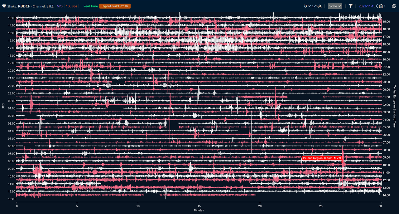
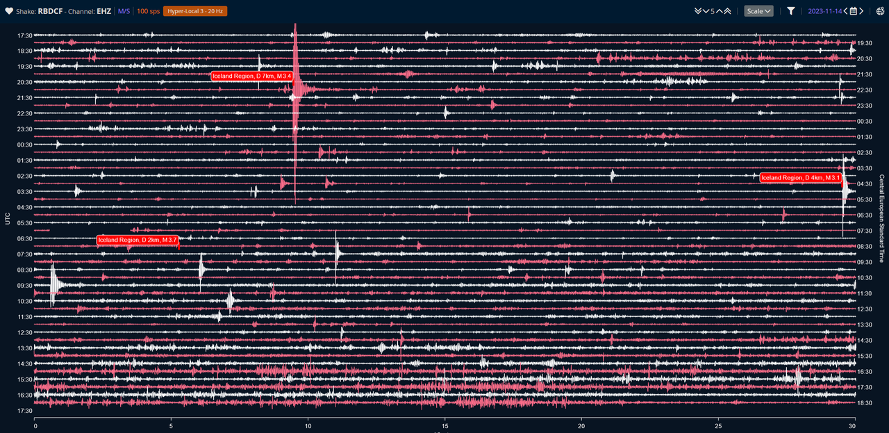
Collection of one measurement station of the past five days. This is the data recorded by the Raspberry Shake sensor RBDCF about 15km north of Grindavik: https://dataview.raspberryshake.org/#/AM/RBDCF/00/EHZ
I set the waveform filter to “hyper-local” which is ideal for events less than 50 km away. Very unfortunate that you have to re-set the filter every time you switch diagrams. What moron programmed this??? 🙁
Scale is set to 4 for least overlap yet pronounced waveforms.
Note: the diagrams run from noon of one day to noon of the next so they cover the second half of the date I gave AND the first half of the next day. The date on the upper right shows the date at the END of the diagram unfortunately.
Nov 10th (Friday) – HUGE quake swarm event on the afternoon, then … silence …

Nov 11th (Saturday) – we start the middle of the day with some “rumbling”, and overall three M3 quakes. You can notice there is generally more “noise” overall than the silence we saw the day before:
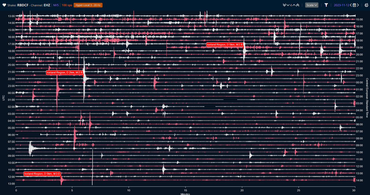
Nov 12th (Sunday) – Overall a bit less noise, but still two M3 quakes. Overall it seems to be calming down:
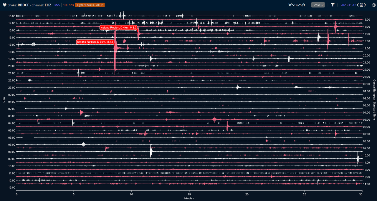
Nov 13th (Monday) – Continuous rumbling around noon and afternoon. In fact you can see it started near the end of the Nov 13th diagram above. Then we have a single big event at M3.4 followed by quiet time, and faint rumbling picking up early on the morning of the 14th:
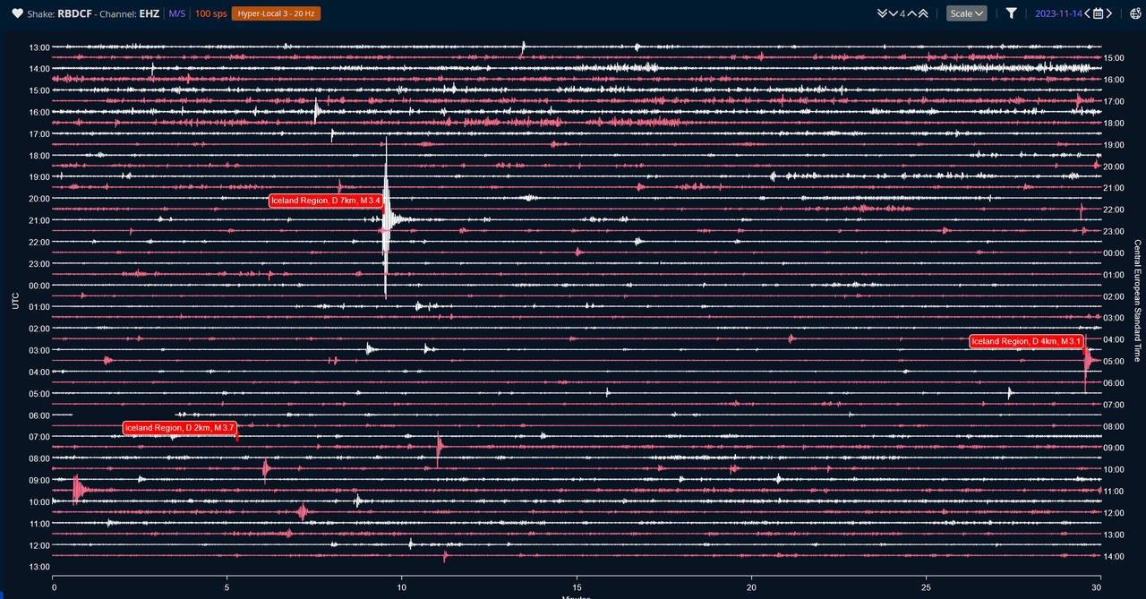
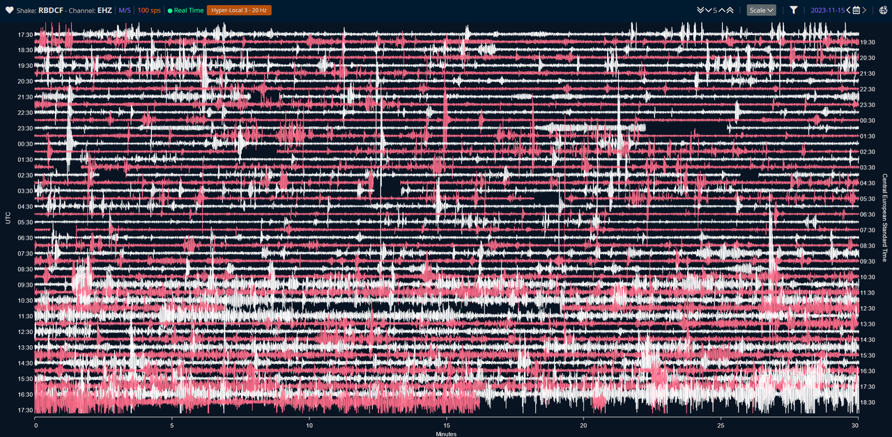
Nov 14th (Tuesday) – NOW we see some continuous rumbling just after noon that lasts until about 18:00. This coincides with authorities warning of increased SO2 measurements in and/or around town in the afternoon (15:00? 16:00?)
We then see frequent ‘bumps’ throughout the night, and this morning (15th) around 9-ish we see more continuous activity although not as pronounced as on the 14th:
But generally, observe as you glance over each day’s diagram that the last diagram shows a clearly visible increase in activity overall. There is no “flatlines” anymore. Which to me indicates subtle and slow but steady activity underground.
The uproar continues. I bumped the scale to 5 (above are 4) to make it stand out more. Again, filter is set to “hyper local”.
13th to 14th:
14th to 15th (now):
What about road noise? Did that get accounted for? The station is near the Reykjanebraut freeway. Could that account for the afternoon traffic around 4 pm or so?
I was wondering about that too. Actually I was thinking maybe that’s the Grindavikians coming in for their “5 minutes at home”. 😉
But I did not see any such pronounced “noise” (eg rush hour) in the days before. See images above.
Here’s the sensor data source: https://dataview.raspberryshake.org/#/AM/RBDCF/00/EHZ
Here’s a GIF of the quakes from the past 24 hours cycling through quakes recorded at maximum depth of 6 km and then upwards to 1 km, in 1 km steps. Red circles are “close to surface” meaning in the 0-2 km range.
Source: https://vafri.is/quake/
This let’s us spot where the earth is moving on a vertical scale without a fancy 3d animations. 😉
Not a particularly great outlook for Grindavik if it’s true that the magma may only be a few hundred meters deep. Of course, quakes don’t necessarily occur where the magma is but then again I find it very unlikely that tension mostly snaps where absolutely no magma is or would love to squeeze through, respectively magma rising elsewhere with no recorded signs of quakes.
IMO it’s either going to erupt in the flat field just north of town or the Hagafell rock 1km to the north.
This is from moments ago:
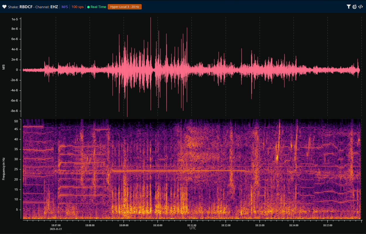
I find that pattern curious. But from what I read, subsurface magma movement would oscillate in the very low band 0.1 to 0.5 Hz, not measurable with this sensor. However, these movements are thought to come with secondary waves in the 5-10 Hz spectrum.
So, by all likelihood, it’s something in a hurry and I’m guessing it’s one of them trucks unloading gravel. 😀
I see. THAT’s what a truck unloading looks like.
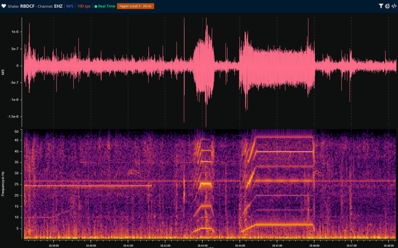
Or what else is this? I have seen these edgy shapes before the past couple days but never this long nor layered atop of each other (multiband). The longer one lasted for 2 minutes.
It does make me wonder what this sensor may be picking up. Home owner’s coffee grinder?
interesting.. could be… very hard to interpret due to all the possible noise sources. But I could spot the big trucks passing by, they were easy to pick out like the sound changing frequency when someone speeds by you.
RUV has a new article with a bit more details, graphics and animations.
They say the magma corridor (intrusion) is up to 5 m wide. They repeat it may be up to 500m to the surface but with great uncertainty. They also cannot rule out that increased SO2 levels may be from Fagradalsfjall.
English translation:
https://www-ruv-is.translate.goog/frettir/innlent/2023-11-15-throun-kvikugangs-undir-grindavik-397218?_x_tr_sl=is&_x_tr_tl=en&_x_tr_hl=en&_x_tr_pto=wapp&_x_tr_hist=true
Icelandic – in case animations generally don’t work in the translation (black boxes with icelandic text) then look them up here:
https://www.ruv.is/frettir/innlent/2023-11-15-throun-kvikugangs-undir-grindavik-397218