
La Soufriere in ashes
Howdy all. Long Time no Sea… 😀
I am one of your dragons. I lurk around in the back channel conversing with the other Moderators. My claim to fame here on VolcanoCafe is that “I plot stuff.” One topic that we have been kicking around, is just how large is the La Soufriere eruption. Albert threw out VEI 4 range as an estimate, I had no idea since I hadn’t been watching. I felt remiss in that, so I spent the evening rummaging around the VAAC reports. Now, first a note. VAAC Reports are SPECIFICALLY for the purpose of providing warnings and alerts for the aviation industry. They are not intended for any other purpose. What I do from time to time, is to use them for an unauthorized or sanctioned purpose. To estimate the eruptive rate of a volcano. Since my estimates serve no purpose other than for us to get a handle on what size an eruption is, and that I make NO CLAIMS as to their usefulness in a scientific or official realm, I think I may be able to slip under the radar and get away with it. The first thing you need to do is to weed out some of the errors.
First of all, VAAC reports are for giving appropriate aviation warnings. These guys are going to error on the side of caution. Warning boxes are of no use for what we are doing. The only data you want are actual reported plume heights. Note the yellow areas in this sample.

Sample VAAC report
This is the only data that is of real use to us. FL100 means “Flight Level 100” Essentially, hundreds of feet. TGMCoy may be able to elaborate on this since aviation is his field. (If he is still using that moniker). In order to convert that plume height to cubic meters of dense rock equivalent, refer to Mastin et al appearing in Journal of Volcanology and Geothermal Research. doi: 10.1016/j.jvolgeores.2009.01.008. The long title of the paper is “A multidisciplinary effort to assign realistic source parameters to models of volcanic ash-cloud transport and dispersion during eruptions”
Essentially, it is a method of getting usable data from what you can find. Their method is derived from work done by Sparks and is generally in close agreement with it.
What I do, is gather all the VAAC reports I can find for a particular eruptive sequence and convert all of the time stamps and data points to the number of seconds from a reference point. To fill in the gaps, I run a linear interpolation from point to point on a per second basis. This is a potential source for error, so keep that in mind. {note, I am not a glutton for punishment, so I used a software tool to do this… specifically DPlot by Hydesoft Computing.} → (Full Disclosure; this is an unpaid endorsement. He is based out of my home state and I’ve had great customer support from him.) Upon completing this step, I now have an eruptive rate estimate for each second of the eruption. I then run an integration step (same software) to obtain the cumulative DRE of the eruption on a second by second basis. This is what it looks like.

See that 4/10/2021 15:55 time stamp? (midway along the curve) that is where the column was reported above FL350, an eruptive rate of 639.68 m³/s.
At over 1.2 x 10⁸ m³… I think it’s safe to say we are in VEI 4 territory now.
A VEI 4 is defined as between 108 and 109 m3 of ash and tephra. Tephra is a lot less dense than dense rock: you get a larger volume out than fits in the hole. To convert, we can use a factor of 2. That makes the current eruption 2.4 x 10⁸ m³. We are in the lower half of that range. A VEI 5 may in the end be possible, if this continues long enough and especially if there is a bigger bang still to come.
Enjoy. Feel free to discuss.

Carl added some notes on misleading information doing the rounds on the wwww, in his inimitable style
I have to write about the eruption at Soufriere Volcano after all of the click-bait that has been written in the last couple of days, and to inject a piece of science into the debate.
But, first I wish to recognise that it is a disaster for the residents on the island. Especially the risk of there not being enough water is scary indeed.
There are 3 things that need to be addressed that is circulating around on the internet and that is amply wrong.
“VEI-5 oh my god we are gonna die!”
No, this is not even close to being a VEI-5 eruption. It is currently slowly moving towards a small VEI-4. There are not many videos of large eruptions, the closest that we have to a VEI-5 eruption is the 2011 Grimsvötn eruption that was borderline, but still not big enough. Please compare that video to what you are seeing Soufriere. The column is taller, and it goes into the stratosphere, it is continuous at this size for 24 hours before it slowly dwindles, total ejecta from the eruption was 0.9km3 of tephra. If you watch the video you will notice that Soufriere is not even scratching on being close size wise.”
“SO2 will cause a volcanic winter/global heating/my grandmothers cat to die.”
No, the eruption is too small for that. In the real world the current eruption in Iceland is about as gassy as Soufriere, and that is a small eruption. None of them will have any effect, you need almost 40 times more, and it must be injected straight into the stratosphere, and be converted into sulphates to have a cooling effect. We know this since Pinatubo injected 19MT+/-4MT into the stratosphere, and that caused cooling. So, way to little, and way in the wrong height…
“Ash column is 60km high!!!!!!”
Sigh, no… The tallest column registered was 17km, and it was short lived.
Now over to the video of Grimsvötn 2011, it is from the opening stage. It is taken from the edge of Vatnajökull 20km away from the eruption for scale.
Carl
VC is always happy to provide the facts and the fact checks. We do like to have our heads in the volcanic clouds, but with our feet on scientific ground!


No need to add this post to the thread….
I’ve been reading articles at the Volcano Cafe for years, and appreciate the sharing of information here. (But have never commented). My understanding of the Flight Level (or FL100 in this example in Geolurking article) is that this is in hundreds of feet, so the ash column in your example had gone up to 100 x 100 ft (10,000 ft). You may have meant that but perhaps a word or two could clarify your explanation. The current ash reports from VAA are in the FL400 plus range ( at least based on visuals and an error of caution, as you point out). https://www.ssd.noaa.gov/VAAC/ARCH21/SOUF/2021D141744.html
Thanks again to the writers and dragons for this great forum!
Pam
That is correct. The post did intend this but it was not clearly expressed for the non-flight specialists. We are always very happy to hear from our readers!
Is that a new vent north of fissure 2?
On Meradalir cam
Ignore. Didn’t realize vent 3 had gotten so big, mistook it for vent 2.
https://www.theguardian.com/world/2021/apr/14/st-vincent-volcano-eruptions-humanitarian-crisis-un
So, seismic gap…I kinda feel that is before a new vent born. Anyway it’s a burst of activity, same as night schedule this fissure got. only long time no collapse…I miss that.
Ups. the #7th son start to spatter tryin to become a decent iceland volcano otherwise look like a giant muddy volc of lava sort
And here a (slow) timelapse from the mbl cam, also covering a day form April 13 8h00 to 8h30 the next day)
https://youtu.be/N4OH5F4F4xo
I’m wondering how much lava’s been erupted from the Geldingadalir fissure system so far? As spectacular it is, it can’t be anywhere near as big as Holuhraun was (~1.2 km2)!
Was 0.75 km2 (10.3 million m3) on April 12th.
Holuhraun is 85 km2(1.36 km3).
Sorry meant “~km3”, not “km2”, but thanks anyway!
Holuhraun was much bigger, and was driven by gravity. It was a very similar eruption to Kilauea in 2018, to give an idea of what it would have looked like under the ice. It also was about the same eruption rate, though being twice as long there was more lava erupted overall.
This eruption hasnt got an observed comparison in Iceland, at least assuming my interpretation is correct, even if it is a shield instead there has only been one of those in the historical period about 1000 years ago. I did pick Lanzarote to compare with this eruption, that was in the end a very big eruption but probably wouldnt have looked that big at any one time, a bit like Pu’u O’o but different style. I expect the eruption rate is still relatively low because magma can still find places underground to fill and create new vents, once this process is complete the eruption rate could be quite high, 30-40 m3/s rather than 8.
I don’t think any shield has formed in Iceland for abouf 6000 years. 😉
Some info from Icelandic scientists today, they think magma activity in the dike is moving southwards and apparently, the dike shows no signs of deflation.
Edit that to 3500 years. Lambahraun is the last shield formed.
last shield was Hallamundahraun, up near Langjokull. GVP has a date for that being in about 920 AD, but it is all pahoehoe so would have been flowing at a rate of about 5 m3/s or less. Given that it is about 9 km3 of lava it could have lasted nearly a century, which would put its end some time around 1000 AD. It was also ongoing at the time Eldgja erupted, so in fact we have got one example for sure of two unrelated eruptions in Iceland at exactly the same time.
As you know though I dont think this will end up as a shield, the eruption rate is too high for that already and evidently there is more magma on the way, this will last years but its goign to be much more visually impressive than a lava shield, at the end we will have some new mountains to name 🙂
Huh..interesting.
All my Icelandic sources list Lambahraun as the last Shield, including Ármann Höskuldsson in an interview two weeks ago.
Oh well 😃
But I agree..it seems like the eruption rate is bit to much for a shield eruption.
Might be because Lambahraun actually looks like a shield, so it might be that distinction. Hallamundahraun is though definitely of this style of eruption, it just didnt construct an obvious shield shape just a massive pahoehoe field.
Flatadyngja near Askja is also a young shield, around 3000-4000 years old.
So I read up a bit about Hallmundarhraun. Definately a lava shield type of flow so I think you are correct in that the distinction is that it didn’t construct a classic shield.
I’ve seen the Icelandic scientists compare this eruption to the effusive phase of the Surtsey eruption
True..but that was I think when it was still at a steady 5m3/s if my memory serves me right.
They were still using this comparison earlier this week so the increased activity up until yesterday was still within comparable rates
Is Jesper OK? I find it odd not seeing his enthusiastic posts…
I was just thinking that myself Clive!
Since he’s so young: could be school exams. They can dampen the spirits.
I know since I’m currently busy torturing (i.e. examining) students over in my little corner…
Comment redacted due to containing a link to a Russian rightwing conspiracy theory site funded by FSB.
/Admin
East coastline of St Vincent after one of La Soufriere’s pyroclastic flows. Quite startling image – https://www.volcanodiscovery.com/soufriere-st-vincent/news/127322/Soufriere-St-Vincent-volcano-update-Strong-explosive-phases-continue-streches-of-coastline-devastate.html
In this article “Soufrière St. Vincent volcano update: Strong explosive phases continue, streches of coastline devastated by hot ash flows”:
“The activity seems to follow a pulsating pattern: Prior to the explosive phases, the volcano is comparably calm, but small volcanic earthquakes under the edifice are picking up until a new batch of magma arrives at the vent, leading to pulsating explosions lasting tens of minutes to few hours, accompanied by strong volcanic tremor. This activity gradually wanes to start a new cycle.”
Are batches of basaltic magma from the subduction zone below entering the magma chamber of this volcano, stirring up the andesite inside it, which causes overpressurizing of the magma chamber?
Town of Richmond Vale, St Vincent’s Island – before and after ash fall
https://video.twimg.com/tweet_video/Ey4kRhkXAAQEnZ5.mp4
USA NASA Modis pictures of Richmond Vale – http://www.ecns.cn/hd/2021-04-14/detail-ihakiuvi4580926.shtml
Reminds me of Plymouth on Montserrat but not nearly as bad. Plymouth was completely destroyed. Wikipedia now calls it a ghost town. Completely covered in ash and pyroclastic flow deposits. Lets just hope this isn’t as extended as that was.
NASA satellite data could detect volcanic unrest years before eruption – https://news.ladizette.com/2021/04/14/nasa-satellite-data-could-detect-volcanic-unrest-years-before-eruptions/
Looks promising, but each volcano is different
barely anything to see on the cams but what a riot those vents are throwing. it may look quite different out there by morning.
With tomorrow windspeed forecasted at 20 m/s and up to 41 mm of rain it might be difficult to see anything in the morning 😔
Just look at that flow coming off the plateau and into Geldingadalir in the left side of the RUV cam.
Phivolcs hasn’t reported any SO2 emissions for Taal in the past 3 days. Correct me if I am wrong when they usually do that, that means there aren’t any significant SO2 emission occurring at Taal now? If it does, seismic activity and deformation hasn’t diminished so that would mean that Taal likely has a plug.
Taal with a plug, what could possibly go wrong?
Everything.
Why are all of the camera feeds black today? (RUV1, RUV2, MBL)
And why has the main reply form here been replaced by a “uwiseismic” YouTube embed? I’m having to leave this as a reply to an unrelated other comment because of that.
If it has nothing to do with a caldera or Katla, you shouldn’t ask me.
Occasionally someone’s comment and the reply box get switched out.
As to the webcams, I think the weather’s so bad that there’s nothing to see. Before the ruv ‘G’ cam went blank, it was very dark from all the weather blowing through.
Just checked them myself. The RUV ones are offline but Viðburðastofa Vestfjarða have a couple of live cams. At the moment they’re showing a lot of fog, mist and Icelandic weather…
Viðburðastofa Vestfjarða channel
Absolutely decent drone footage from 13/4 https://www.mbl.is/frettir/innlent/2021/04/14/flograd_yfir_nyju_gigunum/
Great overview over all the cones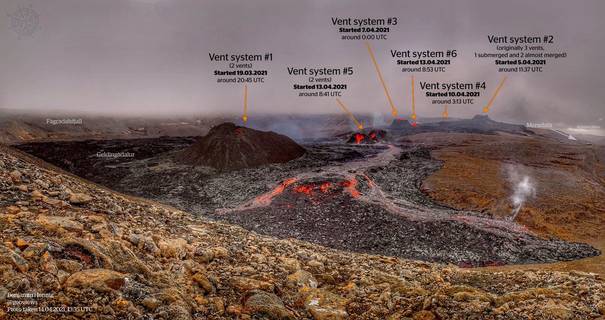
And from above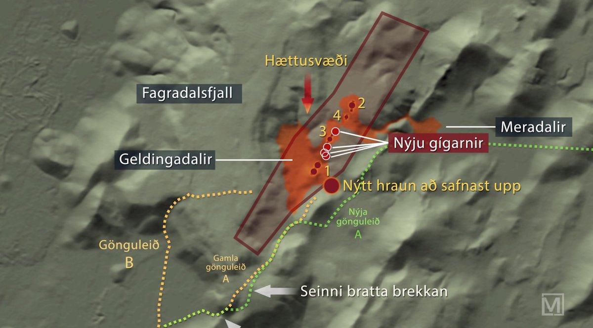
From the MBL site:
The volcanic activity that was previously in the northernmost craters is moving to the original craters in Geldingadalur, which is said to be south, according to volcanologist Þorvaldur Þórðarson. He says that with this, the eruption system is adapting to the landscape in the area.
“The system is realizing that it is harder to keep steam at high altitudes and easier to do so in lower places,” he says. “This is an adjustment to the area and in fact a pressure equalization.”
The productivity of the eruption is the same and there are indications that the activity will remain in the area where it is. There is little evidence that the activity is moving elsewhere.
“It is likely that the activity will gradually shrink into one crater, the lowest crater. I expect it to end in the same place it started when it reached equilibrium. “
Admist the mist of smoking frost he thrust his fist against the post and stills insist he sees the post.
Sorry am bored, miss my firey friends. Boo to crummy weather!
Or is it ‘the ghost’- can’t remember .
Well, imagine being at the site, you can’t see anything except for endless pea soup, but you hear swosh, slosh, splash, roar, but don’t know how close it is…
RVK newscast 95.
https://www.youtube.com/watch?v=8haRjldJcnQ
The best overviews of the whole site, yet…Turn the sound up for the drone shots!
It a newscast with lots of great overviews.
Rustynailer cheers for that-awesome to view,plus the end part of an overview of the site-seeing the cloud shadows sweeping over the hills and gullies-love to be there!
So both RUV cams are offline most likely due to bad weather.
They won’t get fixed until conditions improve.
Lol..this is what happens when on your phone. This was meant as a new comment not a reply 😄
Is it my imagination, or is RUV’s QoS detectably lower than in the first two weeks of the eruption? Seems like their cameras are having both more frequent and longer downtimes. And often simultaneously, which someone speculated might be if the networking was knocked out to the entire area, but that can’t be the cause because this time the mbl cam is still transmitting.
There has been more severe weather lately, then the local authorities has imposed more restrictions on site access that the State Broadcaster has been respectful of.
Today they have a forecast of 20 m/s (~45mph or 72 km/h) wind with drenching rain so understandably they are reluctant to send their techs on-site until after the weather improves
Have been wondering if the current Icelandic eruption may end up a Monogenetic eruption event?
That is the norm in Reykjanes. There is no central volcano, because there is no central magma chamber. Eruptions last but don’t repeat
That’s the normal-wasn’t aware,thanks.
Would probably be fair to compare pretty much all of the western volcanic zone to a very big volcanic field, it is structured because of rifting but eruptions here are pretty much all monogenetic, the only central volcano in this entire part of Iceland that is certainly active is Snaefellsjokull, which is really quite an outlier both figuratively and literally, and has nothing to do with Reykjanes.
Might actually be worth a serious post, discussing the differences between the western and eastern volcanic zones in Iceland, they are very different in character and modern history until this year has only seen one in action.
And also with the entire MAR. I wonder what are the differences between last event and the other deep ocean rift eruptions.
Like your thoughts- perhaps we really don’t understand Icelandic volcanic situation as well as we might think or hoped!
Likely not a ‘perhaps’ but a ‘we have no idea’, truth is we dont even really understand Hawaii as well as we think and that is where we test our ideas on everything else, we didnt even know Kilauea was capable of big eruptions at all and then it throws one of the biggest lava flows we have ever seen right out of the blue. Likewise we still really dont know why Mauna Loa had such a big eruption in 1950, was ‘only’ 0.4 km3 but half of that was in 1 day, it was the closest thing to Laki we have on camera and also far more likely to happen again soon.
Iceland is like Hawaii on an ocean ridge, Vatnajokull actually has a lot of similarities to Hawaii, not least that the magma is near identical, but outside of this area it gets quite different, and the west volcanic zone has little if any hotspot influence at all. Then there is the added complication that what we are looking at now is unusual even in that level, there hasnt been magma this hot and fresh erupting in Iceland for millennia outside of Bardarbunga and Grimsvotn.
Map.is now has the option of showing the lava flow on the maps and aerial images.
Just select ‘Jarðeldar á Reykjanesi’.
They also show webcam locations (Vefmyndavélar).
what map
“Map.is” (there’s a dot, Benja). The site is indeed a good place for maps.
OOOOOOHHHHHHHHH I just lost an hour….. mapppppsssssssssss!
6 vents have opened. Bob: March 19, 20:45, Flo: April 5, 11:37, Sif: April 6, 23:57, Ulf: April 10, 03:14, Rag-Nar April 13 8:28, Hel April 13 8:50 On FLOcam Left: Bob, Rag-Nar, Sif, Hel, Ulf, Flo
https://www.google.com/maps/d/viewer?mid=1e4waWgJKj0cujWRkQyX838qk7t3HblU1&ll=63.89094200000003%2C-22.268198999999996&z=16
but lastnight #7 muddy volcano of lava sort has start to leak a lot….jesus! i wait as thrilled as kids in front of santa the fog to reveal the changes….
One timelapse from the Geldingadalir Ruv camera
April 14, 13h45 -16h00 and 21h00 – 03h45 (April 15)
Due to the fog and rain drifting by it might flicker a bit
https://youtu.be/q4ABmQHdYAM
I have also added 2 fast versions of yesterdays slow timelapses
Find the hole
https://twitter.com/capellaspace/status/1382454043306557442?s=09
Sampling the brand new lava from the lava channel. The effusion rate at the other vents didn’t visibly change when these new vents appeared suggesting there is just more magma ascending and wanting to get out! @Haskoli_Islands
volcanology gp, Nátturufræðistofnun, Nátturaminjasafn
https://twitter.com/RobAskew2/status/1382356240345489412
An english article in mbl.is an interview with Professor Þórđarson, Uni of Iceland.
https://icelandmonitor.mbl.is/news/nature_and_travel/2021/04/15/
“Lava lake likely to flood
The development is quite atypical,” Professor Þorvaldur Þórđarson, volcanologist and PhD, tells Morgunblaðið , speaking of the eruption in Fagradalsfjall mountain, Southwest Iceland.
Typically, in a fissure eruption, the volcanic conduit, i.e. the passage through which the magma rises to the surface, gradually becomes narrower, ending up in one or few craters. In Fagradalsfjall, by contrast, more and more vents have opened.
“This magma is primitive with a high relative density,” Þorvaldur explains. “For a while, its passage was delayed at a depth of one kilometer, as you recall. Due to tectonic plate movement, small cracks or weaknesses in the earth’s crust had formed. The magma took advantage of those.”
He likes to compare these small cracks to straws. Several of them lead down to the magma, and there is magmatic overpressure in the magma dyke.
“That explains the difference in the magma’s surface levels in the oldest craters in Geldingadalir valleys,” he continues. “The magma’s surface has always been much higher in the southern crater than in the northern one. That shows there is no connection between those two vents until the magma dyke is reached. It’s like dipping many straws into the same glass.”
The northernmost crater, above Meradalir valleys, is located at the highest elevation of all the vents. The force in its eruption was vastly reduced yesterday – a logical result of the increased number of vents at lower elevations. In Þorvaldur’s opinion, there was no reduction in magma flow yesterday, which he estimated to be in excess of 10 m3 per second.
Safetravel.is announced yesterday that lava flow was approaching hiking trail A and advised people to exercise extreme caution. Five fissures have already opened at the eruption site.
“A considerable lava lake has formed, and all the lava rivers, as well as craters, are filled to the brim, ” Þorvaldur states. “The sides of the lava lake can burst at short notice.” He believes we will likely see sudden streams of lava start flowing from underneath the lava crust, most likely toward the east. Therefore, he cannot recommend hiking trail A in that area. It ought to be farther away from the new lava, and preferably at a higher elevation, he concludes.
Access to the eruption site is closed today, due to inclement weather – strong winds and heavy rain. To check the latest updates, visit safetravel.is .”
In addition to this, a phrase from (the same?) an interview with Þórđarson posted by Benja I bit above with the newssite (tried to find it, but the newspaper is paywalled).
WordPress is playing tricks not allowing copying gŕŕrrrrr.
In addition to this, a phrase from (the same?) an interview with Þórđarson posted by Benja I bit above with the newssite (tried to find it, but the newspaper is paywalled).
“”From the MBL site:
The volcanic activity that was previously in the northernmost craters is moving to the original craters in Geldingadalur, which is said to be south, according to volcanologist Þorvaldur Þórðarson. He says that with this, the eruption system is adapting to the landscape in the area.
“The system is realizing that it is harder to keep steam at high altitudes and easier to do so in lower places,” he says. “This is an adjustment to the area and in fact a pressure equalization.”
The productivity of the eruption is the same and there are indications that the activity will remain in the area where it is. There is little evidence that the activity is moving elsewhere.
“It is likely that the activity will gradually shrink into one crater, the lowest crater. I expect it to end in the same place it started when it reached equilibrium. “ “”
Interesting. Seems that Askew and Þórđalson are not telling the same story.
In my opnion the first initial twin vents have become less active after the opening of the other vents.
Also the outflow of secondairy vents calmed after the opening of the newest vents, some days ago.
The pressure has been spread over the vents, so that seems logical.
What hasn’t been mentioned, is that the local GPS MERC is still on the move.
That means the fissures capacity is still changing. The pressure remains contant though, so the total outflow of lava as well.
Copyright Univercity of Iceland

Don’t mind the typos 😨
I hate blogs.
From RUV, giggle translated
“The webcams are still disabled
The connection between RÚV’s webcams and the eruption sites was lost on the eve of Thursday. Due to the weather, the webcams have not been repaired and it is expected that repairs will be successful until tomorrow, Friday.
It is believed that the weather at the eruption sites is to blame for the loss of contact with the cameras. There is no mountaineering weather at the moment; fiery and pouring rain.
When the weather allows, a repair party will be sent to bring pictures of the eruption to people’s living rooms. At the same time, it will be tempting to move the other webcam to get a better view of all the new craters that have opened in recent days and weeks. Then the experience will hopefully be better at home in the living room.”
Surprisingly there are only 3 things that stick out like a sore thumb. Giggle seems to be getting better with this stuff
I read somewhere, cant remember where.
The local ground water around the volcano is dangerous to animals, because of the hydrofluoric acid that occurs when hydrogen and fluoride in the volcanic gasses contact and mix with the water.
Hydrofluoric acid is nasty stuff it even rots glass. I am not surprised if prolonged exposure to this eruption gas is damaging webcams. Lenses are glass, I am not sure if that type of glass is susceptible to damage or not. Plastic on its own is OK, that’s how the acid is kept in a lab, wires and plugs, terminals and leads are probably under acid attack when its damp and not freezing, capillary attraction is a right so and so when you least need it to be…
From IMO website
Photos taken two hours apart. In the second photo the lava field has crept over the new Hiking Path A. When comparing the two photos the expansion of the lava field’s edge can be clearly seen. (Photos: Civil Protection Authority/Björn Oddsson).
Time to move to plan B
I’m guessing from the vents behind, this is the SE exit from Geldingadalir.
Wouldn’t be the NE exit? It’s the one that’s been behind the “Twins” on the Geldingadalir cam
It’s actually exciting to go one full day without webcam. Will new vents have formed? Has the lava left the valley? Have some vents stopped working? And so on and so forth. There will be changes, that’s for sure.
In the meantime, I’ve been going back through some of hte archive images and “moving” and refining where the various fissures are on my Google Earth project. The existing maps are ok, but they don’t show the correct shape of some of the longer fissures (i.e. 1 and 2).
Speak for yourself. I am having ‘volcano withdrawal’ symptoms. No shiny lava flows to marvel at and only webcam error messages to replace them with? I actually have to spend more time on my work assignments for a change…
Locals and a few visitors, just casually chatting and sightseeing whilst watching a selection of volcanic vents.
https://www.youtube.com/watch?v=n0HOWWdoLZY
I love what I see, it takes all the worlds troubles away, for me.
Icelanders are a good bunch of level headed folks, in very worried, mixed up world, thank you.
I do not think there are many places that such hands on viewing of raw nature is possible or allowed even if it is possible.
We only live once, as they say.
Iceland the land of a thousand bucket-lists…
Some calculations on total volume erupted, assuming a constant flow rate of 10 m3/second.
Date and time of calculation 16/04/2021 6:00
Date and time eruption starts 19/03/2021 21:00
Number of days erupting 27.375
Estimated eruption rate m3/second 10
Number of seconds per day 86,400
Volume of lava erupted per day m3 864,000
Volume erupted to date m3 23,652,000
Number of m3 in km3 1,000,000,000
Volume erupted to date km3 0.0237
In other news, the UK just had its largest rockfall in 60 years https://www.theguardian.com/environment/2021/apr/15/jurassic-coast-cliff-collapses-in-biggest-uk-rockfall-for-60-years?
There was also a collapse west of the western end of Chesil beach early last year, at Sidmouth.
Nice quake swarm of deep quakes on Reikjanes sea on W point of fissure… i gess.
New post is up! When magma wanders
https://www.volcanocafe.org/a-wandering-eruption/