
Salt structures in Afar
In 1912, Alfred Wegener published his proposal that continents had moved. He presented various lines of evidence, of which the best remembered is the fact that the opposite shores of the Atlantic ocean fit together as pieces of a puzzle. There was much more, including the fact that earthquakes were focussed on the Pacific ring of fire, the fact that the 1906 San Fransisco earthquake occurred on the San Andreas fault, and the rifting grabens of the western USA. Wegener also commented on the region of the Red Sea (see the figure), where also the two sides fit together well. It suggested to him that once, Africa and Arabia were connected and there had been no Red Sea. But there was one place on the Red Sea that did not fit: the narrow entrance of the Red Sea at Djibouti. Close the Red Sea, and this region is double booked, occupied by both sides of the sea. There was too much land here.

Wegener’s drawing of Afar
The Afar Triangle
The double-booked land is also known as the Afar Triangle, a low-lying region wedged into the Ethiopian Plateau. The region is not for the intrepid. The name is synonymous with remoteness. It is also an English expression for far away. This is coincidental (‘afar’ has been in used in English since the 13th century) but it is too good not to mention! (There is also ‘awash’, which happens to be the name of the main river here.) Afar is an unworldly region, in places inhospitable to the extreme, a lunar landscape with brine-filled lakes and boiling geysers. It contains the lowest-lying known continental flood basalt, with kilometer-thick lava bodies now collapsed to sea level – in some locations well below sea level. Here is the lowest-lying island in the world. Some say it is an embryonic ocean, but one devoid of water although there used to be sea here. But there are also mountains, and there are volcanoes, one of which contains the oldest known lava lake. Petrified forests point at a very different past. Once this was an ancient Eden where our ancestral ‘Lucy’ lived. This seemingly unliveable desert is where people first crossed out of Africa. It is also the place where coffee entered the world stage, even though the plant does not grow here. Afar is an enigma.

A combination of Landsat images and ocean topography. From William Bosworth et al, Journal of African Earth Sciences 43 (2005) 334–378: The Red Sea and Gulf of Aden Basins
Afar is shared between four countries, including the smallest (by population) and youngest on the continent. They are Djibouti, Eritrea, Somaliland and Ethiopia. It borders the Red Sea and the Gulf of Aden: Yemen on the opposite shore is just 26 km away. In between lies the Bab-el-Mandeb Strait; it translates into ‘Strait of Grief’.
The name ‘Afar’ refers to the local people. They are also known as the Danakil (literally: people of the Kali, where Kali is their word for Afar). Traditionally they were pastoral with herds of goats, cattle and of course camels. They also lived of the salt trade: there is a lot of salt in Afar. Salt is a necessity for humanity and it becomes valuable wherever there is scarcity. Salt was always coveted, as shown by the many salty expressions in our language, such as ‘salt of the earth’ and ‘worth their salt’, but also single words derived from salt, such as salad, salubrious (you may want to look this up) and salary (that one also). Salt was cheap and plentiful in Afar, and valuable far away: the Afar people were sitting on a gold mine. Of course, that came with problems: there were conquests, wars, and insurrections. It is perhaps not a surprise that two of the nations here are only decades old but there is no Afar nation. If you are keen to visit the more remote areas, armed guards may still be needed.

Triple Junctions
Afar may be the clearest triple point (or triple junction) on Earth. Triple junctions exist wherever three tectonic plates meet. There are around 45 such points known (the number increases when micro-plates are considered). Most of these points are around the Pacific ocean, and only two are on-land.
Tectonic plates can interact in three basic ways. They can diverge, i.e. spread apart. This is called rifting, abbreviated R. They can converge, where two plates collide or one (an oceanic plate) subducts under the other. The latter gives a trench, and it is therefore abbreviated T. Finally the plates can slide past each other in a transform fault. Any kind of fault that is not divergent or convergent is abbreviated F. In a triple junction, there are three connections between the plates (three arms), each of which can do different things. If one arm is a trench, one a rift and one a transform fault, the junction would called ‘RTF’. Not all combinations are plausible, stable or even physically possible (RTF would be unstable).
If the junction is of type ‘RRR’, i.e. three plates all rifting away from each other, the term ‘triple point’ is used. If I counted correctly there are 8 of these on Earth. In a triple point, the crust tears in three directions, 120 degrees apart. Often, two of these tears will develop into oceanic spreading centres whilst the third may eventually become a failed rift, but it is also possible that all three develop fully. Angles of 120 degrees are the ideal case: reality may of course differ.
The Afar triple point is of this type. Here, the tree arms are the Red Sea, the Gulf of Aden and the Ethiopian rift. Two of these have rifted far enough that the old continental crust has split and oceanic crust has begun to form. The third (Ethiopia) has created a rift and is trying hard but has so far failed to follow through. The three arms of the Afar triple point are indeed roughly 120 degrees apart: it is a (or even the) textbook example.
It is also the only one on land. That may not be a surprise: If a triple point develops on land, it will eventually form oceans and now be located in the new ocean. A triple point on-land must by necessity be young or short-lived. Indeed, Afar is relatively young, at 30 million years or less.
The Afar triple point
Let’s look at the arms of Afar. The first arm is the Red Sea which extends towards the NNW. It is 2220 km long and up to 300 km wide. The Red Sea is mainly shallow, less than 100 meters, but there is a small central region which is as much as 3 km deep. The Red Sea is widening by 1 cm per year, mainly because of rotation of the Arabian plate. There is an embryonic spreading ridge in the central region, starting 200 km northwest of the Bab-el-Mandeb Strait, which accommodates some of the spreading. A small region of oceanic crust further northwest peters out near Port Sudan; this lacks a spreading ridge.
The second arm is the Gulf of Aden which extends 1500 km ESE (to the edge of the continental shelf), is 500 km wide and up to 5 km deep. It has a very well developed spreading centre and widens by 1.5 cm per year. The spreading centre is called the West Sheba Ridge. Close to Aden the spreading ridge disappears: the structure continues towards Djibouti as a deep trough without a ridge: this is called the Tadjoura Trough. The trough bends towards the southwest and forms the bay at the centre of Djibouti.
The third arm, the Ethiopian rift, runs SSW and differs in not being submerged. It is some 80 km wide and widens by a measly 2.5 mm per year. The message here is ‘must do better’. South of Ethiopia, near Lake Turkana, the Ethiopian rift connects to the East African Rift system. This continues as far as Mozambique, but it is not a single structure.
The triple point should be where the three arms connect. Sadly, they don’t. Straight lines would connect in the Bab-el-Mandeb Strait but the rifts don’t run straight. The Gulf of Aden bends a little to move into Djibouti: the harbour in Djibouti is in fact the continuation of the rift. The Red Sea rift ends about 200 km too early, near the Golf of Zula. The Ethiopian Rift ends at the southwestern tip of Afar.
Looking at maps of the Afar Triangle, as done by Alfred Wegener, suggests that the original triple point was at the southwestern tip of Afar. This is where the highlands of Yemen fit to the highlands of Ethiopia. Earthquakes indicate another location: they follow a line through the Afar triangle (rather than through the Bab-el-Mandeb Strait) with a triple point near the tip of the Djibouti harbour. Finally, faults in the Afar Triangle show different directions, either oriented along the line of the Ethiopian rift or along the line of the Gulf of Aden/Red Sea. The change occurs in the centre of Afar, indicating a triple point near Lake Abbe. This triple point has three possible locations! It is complicated. Over millions of years, much can change, and fixed points may not remain fixed. Triple points too may search for greener pastures.

Source: Conti et al 2015, Rift-Related Morphology of the Afar Depression
The diverse Afar Triangle
It has a dry reputation. Tourists visits the Afar Triangle to find an extreme desert. But it is no Sahara. The region is large and is remarkably diverse. It has desert and shrubland, deep basins and mountains, rivers (one, to be precise) and shorelines, and there are several clusters of volcanoes.

Life on the dry plains of Afar
The map above lists the various regions. Afar is mainly a low-lying plain, lowest in the north and dotted with volcanoes. In the west and in the southeast the plains terminate against steep escarpments up to the Ethiopian and Somalian plateaus. Here lies the origin of the Blue Nile which only just misses falling in to the Afar Triangle and instead begins the long walk to freedom Egypt. The escarpments are along 60-km long fault lines which are no longer active. Along the coast are two mountainous ridges, the Danakil Block and the Ali-Sabieh Block, dissected by the harbour of the Djibouti (the Gulf of Tadjoura), one of two sea arms entering Afar: the other is the Gulf of Zula. The low land in-between the mountains and the escarpment contain a series of basins, separated by fault lines. There are lots of fault lines! Some of the basins lie below sea level. In fact, both sea arms could be considered as submerged basins.
The map below shows much more detail and may be useful for the following discussion of the different regions.

The Danakil Depression
The most famous of the deep basins in Afar is the Danakil Depression, in the north of the Afar Triangle. The region lies more than 100 meters below sea level, and as low as 190 meter below sea at bottom of Lake Afrera. It is separated from the Red Sea by a mountain range. In the shelter of the mountains, the climate has grown hot beyond belief. Winter is the only time for survivable tourism (under armed guard though). Dead Valley, eat dust: the Danakil Depression may be the hottest place on Earth. Whether it is is not really known, as there are no permanent and validated thermometers here. The highest reported temperature is 148 F (64 C), but this has not been accepted as an accurate measurement.
Rain water from the mountains (not the Awash river as claimed by Wikipedia: that flows away from this region) and hot springs have formed some lakes in the Danakil Depression. They are hot and hypersaline. The salt used to be mined but since the eruption of Nabro in 2011 some of it has become too polluted with sulphuric acid. The hot springs here too add to the climatic heat, giving geysers and wonderful colours which few people will ever see.

Hot springs in the Danakil Depression. Source https://www.bbc.com/future/article/20170803-in-earths-hottest-place-life-has-been-found-in-pure-acid
The Danakil depression acts as a wanna-be oceanic rift: it has a similar structure and (in places) similar volcanic activity, but as of yet it remains a superficial break in the continental crust and lacks the depth of an ocean. The similarity to oceanic rifts is reflected in the occurrence of long dikes. These accommodate spreading by injecting magma into the rift, but don’t necessarily erupt: magma mostly stays underground. The most extreme case of diking seen here was in September 2005, when a dike propagated over 60 km at a depth of 10 km, leading to a staggering 8 meters of spreading. This was between Dabbahu and Manda-Hararo on the map, between the Danakil Depression and the Tendaho Graben. The intrusion ended with a minor fissure eruption.
Awash
In the southwest, the Ethiopian Rift enters the Afar Triangle as the valley of the Awash river. The point of entry is at the Fentale and Dofen volcanoes. The river continues due north in the Triangle, close to the escarpment, while (just) avoiding the deeper Issa Graben to the east. In the future, this graben may capture the Awash.
The Awash river forms a ribbon of green in this barren landscape, complete with trees. The ribbon is surrounded by shrub land, feeding herds of zebra, the few remaining Somali wild ass and of course Egyptian vultures who have plenty of cattle carcasses to feed on.

The Awash river at the southeast tip of of Afar
Lucy
The Awash Valley is famous as the place where Lucy (last name unknown) lived and (perhaps more importantly) died. She is our famous human ancestor (australopithecus afarensis, to be precise) who lived 3.2 million years ago. Her remains were found in 1974, in the area where the Awash river runs north along the escarpment. On the map, it is (probably) near the ‘V’ of ‘Awash Valley’.
The discoverers recall how they found the bones of the single individual (extremely unusual, and yes, she was female). They were dancing like madmen in the stifling 40C heat. In Lucy’s time, this area was more wooded than it is now, but Lucy was mainly ground dwelling and walked upright. The area was already volcanically active: her bones are dated using two layers of volcanic ash below and above her remains. We don’t know how she died: one theory is that she fell from a tree but the discoverer strongly disagrees with this idea. However she died, her death made her famous.

‘Camp Hadar’, showing the river valley near the location of Lucy. Source: https://www.donsmaps.com/lucy.html
Lakes
The green ribbon of the Awash does not last. The river bends east away from the escarpment, enters the Tendaho graben and becomes lost in this dry land. It ends in a series of lakes, which have become very salty from the evaporation. Eventually, this leads to Lake Abbe, at 160 meters elevation and saline, from where there is no escape: volcanic plains and hills block the exit.
Lake Abbe (also known as Abhe) is the location where the faults stop following the line of the Ethiopian rift: north of the lake they run along the axis of the Red Sea. This is often considered the current location of the Afar triple point. Lake Abbe is known for 50-meter tall limestone chimneys, formed by hydrothermal activity. It is also home to flamingoes. The surrounding region has become a salt plain.
Other lakes in the region are even more hostile. Lake Assal, northeast of Lake Abbe, is near the end point of the Gulf of Tadjoura. It lies at an elevation of 160 meters below sea level. In between the lake and the Gulf of Tadjoura lies Ardoukoba volcano, 300 meters tall, which formed in a rift eruption in 1978. Volcanic plains keep the sea away (although there is some seep underground). Lake Assal is an obvious continuation of the Gulf of Tadjoura. In fact, it used to be sea but it became separated by the volcanic activity.
Lake Assal is among the most saline lakes in the world, with salt content of 35% to 40%.
It is not the worst case in Afar: the lakes in the Danakil Depression win the inhospitability contest hands-down. Gaet’ale Pond is the worst at 43% salt concentration: it is second or third in the world salt sweepstakes, behind only Don Juan Pond in the Antarctic at 45% and Lake Elton in Russia at 50%. (There is some dispute whether Don Juan Pond still exists.) The pH of Gaet’ale Pond is as low as 0.2. (Coca-Cola Company: take note.)

The Ethiopian escarpment seen from the Somalia plateau. Source: Coltorti et al. 2015, https://www.researchgate.net/publication/284146632_Planation_Surfaces_and_the_Long-term_Geomorphological_Evolution_of_Ethiopia
Alps and mountains
Along the coast lie two mountain ranges, the Danakil Block and the Ali-Sabieh Block. The two blocks are separated by the Gulf of Tadjoura but geologically are part of the same structure. The highest part forms the Danakil Alps, north of the Danakil Depression and located in Eritrea. They are also known as the Arrata. Seen from From the Danakil Depression, they form a steep escarpment; the slope on the other side towards the Red Sea is more sedate. The steep escarpment is of course a fault line. The mountains here are up to 1 km high, and are arid. The mountains continue towards Djibouti but become much less high and no longer considered ‘Alps’.
At the southeastern end of the Danakil Alps, standing well above the rest of the range, is Nabro stratovolcano at 2 km high,, which had a large eruption in 2011 It contains a large caldera, open to the southwest. Mallahle volcano, 1800 meter high and with a similarly sized caldera is close and may be linked. A bit further away is Dubbi volcano which erupted in 1861.

Dubbi volcano. Source: Clive Oppenheimer
Structurally, the Danakil Alps, the extension towards Djibouti (together called the Danakil Block) and the Ali-Sabieh Block were once part of the Ethiopian highlands. Together they are considered a microplate. It is now stranded, rifted from both the Ethiopian and the Yemeni highlands. Something has happened here.
The making of Afar
To be continued
Albert, January 2025
Come back next week to hear about the messy play of plumes and a flood that formed a sea!

Mount Asmara, Afar Triangle


Albert,
You might know this paper, I think it is interesting, also for others:
https://doi.org/10.1029/2021GC009985
Was Iceland once the location of a Triple Junction? When the Atlantic Ocean rifted, there occured a swarm of several other failing rifts, that for a while behaved like real rifts with extension and volcanism. There were f.e. the UK volcanes (NAIP), the Faroe volcanoes and the North Sea rifts. Towards the north Greenland divorced from Labrador.
The Icelandic Hotspot on this position is probably too young for many of these failed rifts, but it’s imaginable, that there were rift zones before the hotspot arrived on the voyage from Greenland.
The Atl Ocean rifted first in the middle where is now the convex bow of North Africa and on the other side the big bay of the eastern United States.
An igneous province called Central Atlantic Magmatic Province is thought to have to do with this.
The age of the oldest crust is ~ 200 million years.
After that it opened south and north with resp. flood basalts like the North-Atlantic Magmatic Province. There must be papers about the age of the oldest crust there (east and west of Iceland), you will find them.
Iceland wasn’t present. Iceland is believed to be ~ 20 million years old, oldest rocks found 16 Ma.
The Aegir rift east of Iceland is an example of a failed rift. It looks like it would continue onwards to the Hreppar block if it had continued. &f=1&nofb=1&ipt=45d26c21addcb3bd7b2e923a38d07ecbf8df04d3d4fe9b895847f452e2e3aec3&ipo=images
Sorry wrong image:
 &f=1&nofb=1&ipt=f2349ddea4a740591f70b81acaa1cbc63a044a32e5b8c40568004b29d7143967&ipo=images
Is the Iceland-Faroe Ridge an old rift system? Maybe there already was a triple rifting system on the present location of Iceland, before the Hotspot from Greenland arrived.
Nice. Failed rifts are often neglected.
Kilauea episode 6 is underway, quite a bit stronger than 5 was it seems.
Thanks! I have watched and noticed that already 18 p.m. there were Strombolian eruptions on the cone:
https://www.youtube.com/usgs/live
Did the eruption really stop or did it continue silently without public notice?
HVO has answered the question. Strombolian activity on the north vent preceded the onset of the main Hawaiian activity at 9:45 UTC:
“Kilauea Message 2025-01-25 09:45:12 UTC
Episode 6 of the Halemaʻumaʻu eruption began at about 11:28 p.m. HST. Continuous small dome fountains about 10-20 ft. high are feeding a short lava flow.
Kilauea Message 2025-01-25 07:23:49 UTC
Small, sporadic spatter bursts began from the North vent around 6 p.m. HST on January 24. At 9:15 p.m. spatter continues but has increased in frequency and intensity. Episode 6 has not started, but eruptive activity could resume soon.”
It hasnt ‘stopped’ at any point. Pauses arent considered the stop until its been long enough to be clear resumption isnt going to happen again. Other summit vents that died did so completely, the vents werent degassing or still glowing brightly days later, unlike now.
Basically HVO considers the eruption continuous, but only when the vent overflows is an episode ongoing.
Its looking like the ongoing episode 6 might stop soon, too. Episodes 1-4 had net loss of magma from the summit, but 5-6 have been shorter and not as voluminous, and 6 started after a little extra than 5. So its possible these short episodes every few days might be the new norm now, and that summit pressure will gradually increase overall from this point.
On this, the episodes recently have all been ending when the deflation gets down to the trigger point for the eruption last September. That was down on the ERZ, so the summit inflation after that could be seen as extra pressure that was relieved by episodes 1-4. It is very hard to see E5-6 on this graph though…
I guess, there are two optiong going forward. Either the episodes and pauses merge and a continuous outflow builds a shield around the vents. Or the episodes become shorter and gaps longer, but the actual lava effusion is very intense and fointains get extremely tall. The start of E6 had some pretty big fountains probably going well into the 100 meter range, much above E5. So likely scenario 2 short term, maybe turning to 1 at some point later.
Wasn’t there a rule that the height of a lava fountain shows, how high a spatter cone can grow? If this also applies here, this may be a sign how high the lava field/shield is going to grow, before something else happens.
Its more arough correlation that the average height of the fountains is about how wide the crater of a cone would be if created. But its pretty loose, I watched episode 6 start live and lava was being sprayed onto the walls far above the cone early on. Its more applicable for eruptions with continuous and sustained fountaining, the 2021 cone on Fagradalsfjall doesnt give any indication its vent had spawned 400 meter lava fountains at times.
Actually I just noticed on here, this is the tiltmeter at SDH. Green tilts away from the south caldera, radial to the start of the SWRZ connector where the eruptiin in June was. Blue is radial to Halemaumau. Episodes 1-4 saw equal drop at both, so magma was withdrawn from both. But 5-6 have barely caused any blip on this graph, and the overall trend through both was a slight upward. So im more confident now that equilibrium has been reached and pressure will only increase from this point unless something changes again.
And episode 6 just stopped… E7 on January 28-29 and E8 on February 1-2.
I have the impression that the eruption continues with Strombolian activity: https://www.youtube.com/watch?v=w0KulR_3wQk
There is always glow, and sometimes some spattering.
If this is true we now have a continuous eruption that on low level only does Strombolian spattering and during the episodes effusive activity.
The eruption is ongoing, just not active overflow of the vent which is what the episodes are. Its the same as at Pu’u O’o, it often went over a month between episodes before 1986 and often without continuous visible glow either. And it was also common after 1986 for there to be no surface lava at all on the flow field all the way to the ocean. There was like 3 months over New Years 2017 where the first time the lava saw the atmosphere was at the sea cliff of Kamokuna, immediately at the ocean, and on land was only glowing skylights. As well as pauses of weeks looking totally dead in 1997, 2007 and 2011. And over 3 months for Mauna Ulu, but in none of these cases was the eruption not considered continuous in the Global Volcanism Program definition (HVO differs slightly on this).
It also looks like the south vent actually isnt dead, its glowing a bit now and did erupt a bit in episode 6, but its definitely secondary at this point.
There is also some lava leaking out of the flow field below the B2 cam. Im not sure it has been determined if these ooze out flows are lava pushed out of the surface flows created by this eruption, or if it is lava pushed out of the deep lava lake in the caldera, maybe squeezed out by the weight of the new lava on top bending the crust and cracking it. Its likely both of these things really.
It would be interesting to know the characteristics of the lava in the caldera now after a lot of it is over 4 years old. The lake is so deep the center is over 200 meters away from any of the edges in any direction, I have doubts it has cooled really at all there, though is probably very dense and maybe like molten glass.
It may have settled into a pattern of smaller more frequent episodes.
Ye, it doesn’t calm down to a “dormant” state now between the episodes, but keeps a low level of minimum eruption. Maybe the webcams don’t catch the important parts enough. But I’ve noticed that the steam vent in the foreground of the webcam has been very active throughout the whole series. It is a strong, steady hydrothermal Fumarole, that is illuminated during the episodes by lava glow.
Added to this it’s possible that there continues some quiet magma/lava flow below the surface to the lava field/lake.
However, the whole flat lava field on former Halema’uma’u and the down-droped block with several smoking cones now looks more like some 19th century pictures of Kilauea caldera. It reminds to Mordor …
I thought that steaming area might erupt a few weeks ago, but now seeing it is just white steam and other vents have been dying back to a single mature vent. So I think it might have been an area that was probably very close to erupting early on but didnt quite make it. Interesting that the now dominant north vent was a minor fissure on the opening day.
Regarding actual visibility though I think that is weather. The SO2 from the vents will condense water and make the blueish steam but the white steam at other random fumaroles is literally just a cloud or fog.
Tilt has 1 microrad to go to reach the E6 threshold. At that rate it will take about another 10 hours or so. I had guessed January 28-29 local time but that might have been too conservative…
There is a live feed from Scott: https://www.youtube.com/watch?v=WBH99dj15bo
There is a slight downturn on the east and up positional GPS data for teh THOB 8 hour GPS station. See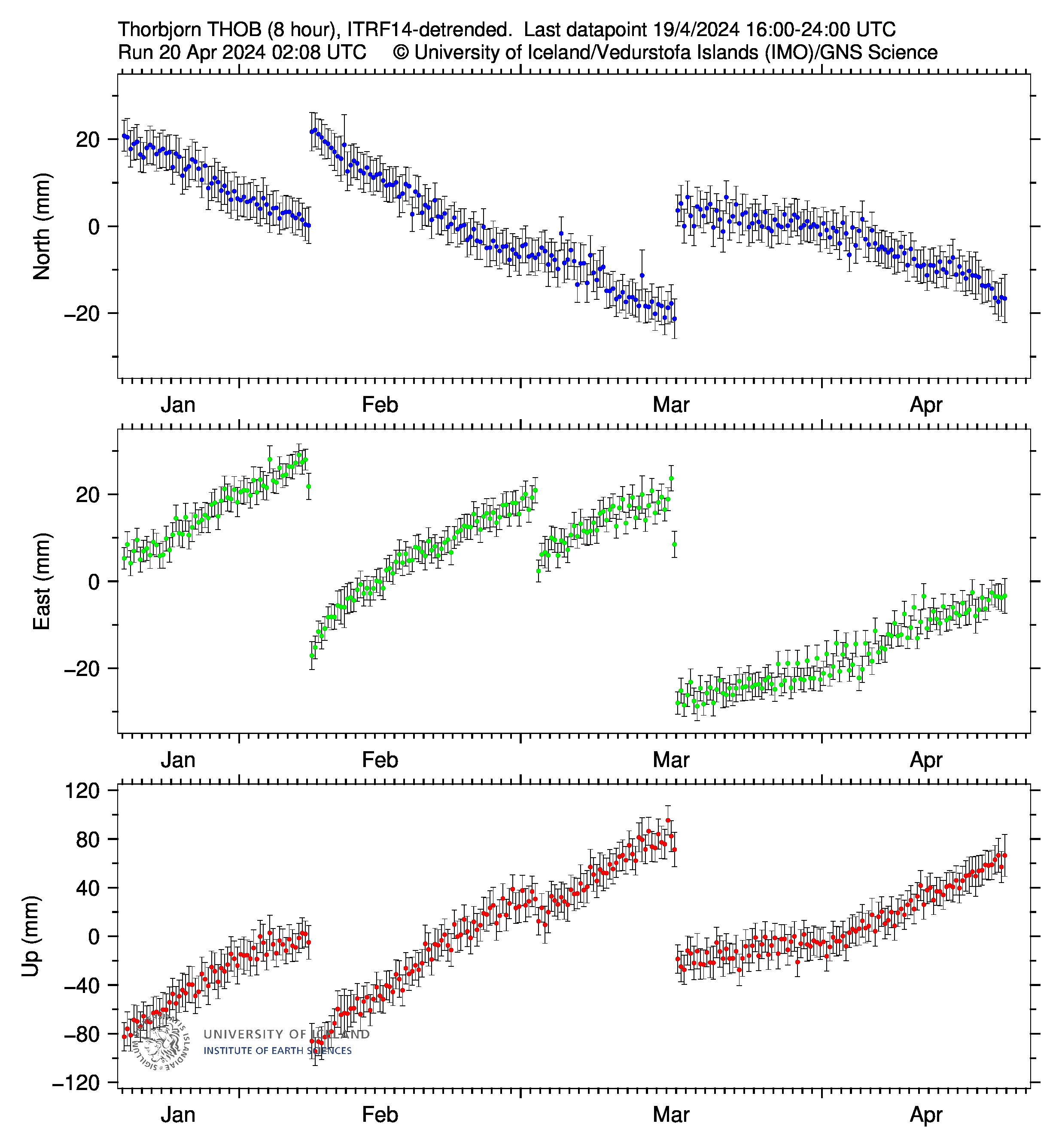 . I would interpret this as a possible indicator that we are close to another fissure eruption in the Svartsengi area.
Early February or late January is what I have been seeing, so from about now onwards is likely. Would be a crazy night of watching if Kilauea had an episode at the same time as Sundhnjukur was in the curtain of fire stage. But theres always the risk Grindavik is lost next time…
Are earthquakes at Krysuvik an indicator for a coming eruption at Svartsengi? The rising pressure in Fagradalsfjall-Svartsengi’s magma system may increase tectonic pressure on Krysuvik’s system.
It looks today like the pressure is increasing around Sundhnukar for the first time for some time. The whole peninsula seems to be groaning today.
Then I expect that the eruption can begin before 30th January … but impossible to predict. We have to wait until the “borehole method” gives a sign.
As usual I want to point out that the shift in slope of the E-W component to a less easterly/more westerly trend is present in a large number of stations as far away as Askja. It’s very likely a common error. GPS data needs to be evaluated over longer periods and by looking at the combined picture given by several stations.
That said, the volume of accumulated magma is now at the point where an eruption is becoming more likely, what IMO is referring to as the lower limit. That means an eruption can start soon, but it can also be several weeks left. Looking at the overall picture across Reykjanes, the GPS motions are slowing down. It might start to take longer between eruptions or activity might shift elsewhere.
Can the moment, when GPS movements are decreasing, be the one when pressure shifts from solid environment of the dike towards the magmatic conduits?
I imagine that the continuing geothermal heat in the established fissures keeps the pathways for magma open so that there are only fluids (magma/drained lava) that have to be pushed out to make a sudden eruption. If there is a point which has less anti-pascal than the pascal of magmatic pressure, there goes the eruption.
I meant the overall GPS movements since the start of the first eruption, not just the buildup to the next eruption. Look at stations like STAN, FEFC and RVIT. They are all slowing down.
Re the discussion about the clouds inside the Fentale caldera, I just read the latest USGS Smithsonian report:
So “thermal anomalies” on satellite IR. Not enough to be an eruption but may well be the explanation of the clouds in the caldera.
Sounds like theres a new fumarole or similar. The caldera looks like it had some notable subsidence at some point before the last set of flows within it erupted. I would guess, if the last eruption there was similar to now there was probably rifting and caldera collapse to some extent, with the recent flows erupting through the cracks. Maybe there is something similar within the caldera now but before any eruptions.
So its plausible some rhyolite flows will erupt in or near the caldera soon. Its also always likely some basalt will erupt as long as the rifting is ongoing.
Thanks, that’s interesting to know.
Very dangerous political/historical situation in Nyiragongo’s environment: https://www.reuters.com/world/africa/congo-repels-overnight-rebel-advance-goma-city-say-sources-2025-01-25/
I actually missed this live, but right after the last episode at Kilauea there was a major crustal fou dering at the vent. HVO mentioned it in their last update, and when they use the word ‘massive’ it means something
https://youtube.com/shorts/ej0b2kxydtw?si=f-DNheBCH1tkBGY5
“Lava flows from episode 6 covered nearly half of Halemaʻumaʻu crater floor. A massive overturn of erupted lava started around 1:58 p.m. during drainback into the north vent, and the lava surface level in the center of the crater floor dropped about 1.6 feet (0.5 meters)”
Really gives the clearest demonstration of how fluid this lava actually is. It looks like a liquid metal. I can only imagine how crazy it would look if the liquid interior of the lake drained out, causing the whole caldera to founder like this all over.
It’s becoming a “convecting conduit” that can move magma/lava up/down like a lift. If the lava field level increases, the vent may turn into a lava lake like Overlook Crater.
No but eventually that is likely.
Completely amazing and thats the center of the rootless lava lake thats overturning, yes very very very fluid indeed looks like liquid iron , or iron slag thats bubbling, but the scale is enromous too so it looks more fluid than it woud be at 1 meters scale, hard to grasp the scale of halemaumau without scale bars, but yes very fluid… indeed
New post is up! The pointless plume
https://www.volcanocafe.org/the-making-of-afar/