This is quite an eruption, with surprises with every new turn of events. It is an unusually tourist-friendly eruption: conveniently located, small, non-damaging (except to the owner of the land) and spectacular. It does appear that not all tourists are as friendly to the virtual tourists, judging from the antics going on in front of the cameras, but that is what it is. Even the local foxes have been photobombing the eruption.
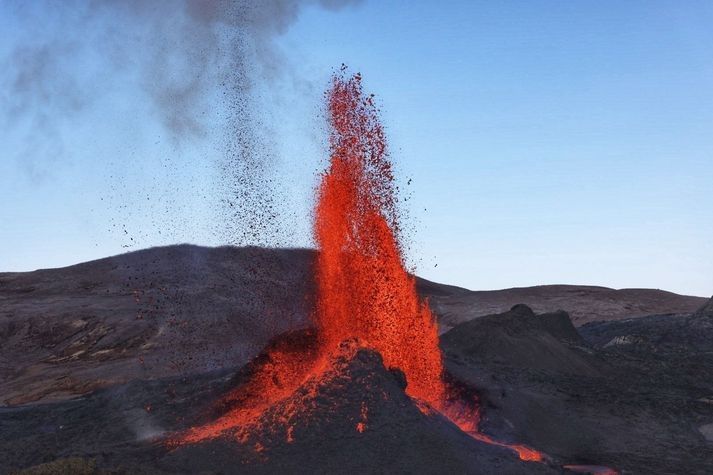
It is very notably a dike eruption. It started out as a dike several kilometers long, forming at a depth of 6-7 km and growing upwards towards the surface. A whole series of cones have formed along a kilometer-long fissure where the dike reached the surface. For a long time multiple cones would be active simultaneous, but the eruption has finally gone conventional with fountaining and effusion only from a single cone. The cones have shown a notable tendency to go double, with two lava exits close together along the line of the rift. In each twin, the cones were acting fairly independently. From the distance between the twins, we can estimate that their lava feeds separated perhaps 50-100 meter below ground. This is not an entirely stable situation, and over time one of the twins will become dominant and finally exterminate its sibling. That indeed happened in all sets of twins. The surviving cone too has extinguished its sibling.
We might have expected the dike to reach the surface at the lowest point along the dike. To some degree this happened as the eruption started in a valley. But strangely, the eruption avoided the lowest ground in the valley and it first erupted on top of the only hill within the valley. When that wasn’t enough, it went for the higher ground next to the valley. It never extended into the much lower ground further north or further south, on either side of Fagradalsfjall. There was a bit of anti-gravity about this. Why was this? Clearly, the road from dike to fissure was not entirely straightforward.
To making of a dike

A fossilized dike. Source: wikipedia
How does a dike form? Obviously, magma gets in between the rocks underground and slowly pushing them apart. The dike extends both upward and sideways, and eventually becomes a wall which can be kilometers long and tall, but only a meter or so across. It is like a very large sheet of paper, slowly making its way vertically into the crust.
Where does the magma come from? There are two parts to this question: where was the magma to begin with, and how does it get to the dike? As for the origin, the magma can either make its way up from the mantle through a conduit (as seems the case in Reykjanes), or it can come from a magma chamber that is already in the crust (as was the case in Holuhraun). That magma chamber is in most cases (but perhaps not always) located underneath a central volcano. In both cases, the magma feeds the dike from a particular entry point, and the dike grows sideways from there. If the dike is fed from the mantle, then it is also possible that there is no single conduit, and that the dike is fed from below along its entire length, but this has not been observed in practice. As far as we know, a dike starts with a bottleneck.
Why does the magma form a dike, rather than a conduit up to the surface as it does in any normal volcano? This is the all-important question. Dikes form if there is some weakness in the land. Volcanoes grow on strong land. Long-distance dikes feed on weakness, on land divided against itself. They grow best on rifts.
Let’s look at two examples. The first is, of course, Hawai’i. It has impressive, in fact world-leading, volcanoes. ‘World leading’ can sometimes have a rather subdued meaning in the US. For example, the ‘world series’ is not quite what it seems as only teams from the US and Canada are allowed to take part. The ‘world’ is not allowed to play in the ‘world series’. That’s just not cricket. But Hawai’i can and does compete with the rest of the world. Its top-heavy volcanoes are riddled with rifts, and many eruptions come from dikes following those rifts. This happened in the Leilani eruption of 2018, from a rift which was tens of kilometers long. Many of Hawai’i’s rifts follow the line of flank failures on older volcanoes. If you stand on the shoulder of giants, you also inherit their problems. The weakness in Hawai’i is very much self-induced, a consequence of the immense size of its volcanoes.
The second example is Grimsvotn. For such an impressively erupting volcano, it actually looks a bit small. Bardarbunga is far more imposing. Why is this? Grimsvotn is a child of the spreading rift that bisects (possibly quadrusects) Iceland. The rift forms a line of weakness, and it provides the magma with a tempting escape route. Grimsvotn is a young system that recently (geologically speaking) formed on the rift. It does not have a strong a magma chamber, its summit eruptions are small (although very frequent) and most of the magma goes into the rift. Laki stole its magma from Grimsvotn, either directly or by intercepting the supply. ‘My volcano is my castle’ does not work if you built the thing on a rift.
Bardarbunga once also formed on the rift but it is an older system and it has moved with the times. As the spreading rift spread, it took Bardarbunga with it and over time the volcano slowly migrated away from the rift. This made its magma better contained because it is now further from the weakness of the rift. Not perfectly, though: often its magma chamber will spring a leak, the magma will find its way to the rift, turn north or south following the spreading rift, and produce a fissure eruption far from the embarrassed volcano (who, me?). This happened in 2014. But a decent amount of magma remains confined to its magma chamber and this produces summit eruptions, or otherwise just pushes up the volcano. (Much of the growth of a volcano happens underground. Summit eruptions have their role but don’t do all the work.) So Bardarbunga grew large, while Grimsvotn with its much higher volcano-metabolism remained smaller. One day Grimsvotn too will find strength away from the rift and grow to become a giant. And Bardarbunga will have moved too far from its magma supply, and decline.
So you have magma, and you have a rift. What happens next? The magma finds it easy to push in the direction of the rift. This pushed the rocks apart in a direction they want to go anway, because it is the direction of the rifting. The magma is pushing at a nearly open door. Going in the spreading direction, perpendicular to the rift, is much harder. That requires pushing the rocks in a direction they do not want to go. Magma, as a liquid, always takes the easiest path. So the magma prefers to move along the rift, not perpendicular to it. That happens both in Hawai’i and in Iceland. In the right circumstances, the magma can travel unopposed for tens of kilometers – but only along one direction.
When a dike begins to grow, it tends to follow the line of the rift. The growth can be followed quite easily, because of its earthquake activity. The tip of the dike has to break the rock apart, and this gives a lot of small shakes – almost explosions. While the dike lengthens, it may also grow thicker, but this is mostly a silent process which does not cause earthquakes. It does not involve new breakages, just widening a crack that already exists. So while earthquakes detect what happens at the ends of the dike, the centre moves quietly and secretly.
So this explains how a dike grows long and wider (‘wide’ is the wrong word though for something that is 10,000 times longer than it is wide). How about moving up? After all, a dike doesn’t do much unless it can reach the surface.
It turns out, up is also a hard direction. Gravity complains, and when gravity has the weight of 5 kilometers of rock behind it (or above it), it is hard to go against it by moving up in the world. It is not as hard as going perpendicular to the rift, because going up pushes the rock in the spreading direction it prefers to go, but it is much harder than going along the rift where the weight of gravity does not work against it. That magma may have some buoyancy which gives a bit of a push upward, but it is still hard. So the magma can move in three directions, but they differ in difficulty. Easiest is horizontal along the rift, harder to move vertical, upward, and impossibly hard to move horizontal but in the direction of spreading. This is why dikes become like sheets of paper, and why this only happens where there is a rift to give a preferred direction.
In the absence of a rift, all directions become hard. Magma does not find it easy to move against an undivided land. That is one reason it collects in magma chamber: it is hard to get out! But physics still acts, and physics says that in such cases it is easier to move sideways than upward. In such a case it forms a sill, a horizontal dike.
As an aside, comparing Reykjanes to Vatnajokull (Grimsvotn and Bardarbunga), one thing immediately stands out. Dikes in Reykjanes are only several kilometers long, perhaps up to 10 kilometers, while Bardarbunga’s dikes can reach over 100 km from the volcano and Grimsvotn, in spite of having quite an immature rift system, also has a long reach. There are two reasons for this difference. One, there is much more magma available in Vatnajokull because it receives more mantle heat. Ten times more heat should give ten times more magma and this should allow for ten times longer dikes, all else being equal. Second, there isn’t a clear spreading rift in Reykjanes. Instead, the rifting is taken up by numerous mini rifts, located along the Reykjanes fault line. As a result, eruptions in Reykjanes are rarely more than a few kilometers from the central fault.
The topography of the surface began to play a role. For there are dungeons and dragons here, or rather, valleys and hills. Where there is a hill, kilometers down there is more weight to carry. This affects the magma dike. To understand how, we need to go back to Holuhraun.
The Holuhraun dike
The Holuhraun eruption was fed by a very impressive dike which did not play according to the rules. It ignored the straight line and followed a roundabout route. First it went east-southeast from Bardarbunga. Then it waited, and changed direction to north-northeast. There were several more changes of direction. Why?
The answer is that the direction a magma dike takes is a combination of the spreading axis and the local topography. The basic principle is an easy one: magma will always take the easiest path. This is, the path that requires the least energy. The energy is used for two things: pushing apart the rock, and pushing up the ground above the dike. The energy needed for the latter should not be underestimated. A 4-kilometer deep dike carries 12,000 tons above every square meter. Pushing this up requires a lot of energy. Pushing up the ground is easier when the ground is lower, so the dike prefers to take the direction where the ground slopes down steepest.
What if this is not the direction of the spreading axis? Then the dike will find a compromise: it will go into a direction which is not quite the spreading axis, and not quite the lowest direction, but is the most efficient. It is called the principle of minimum energy. We can calculate at every point which direction requires the least energy. And indeed, the dike took this direction at every turn. The initial ESE direction was down the slope of Bardarbunga. It reached the rift at the saddle point where it turned north. Now it followed the rift direction in general, but with various deviations. This is described by Sigmundsson et al, Nature, https://www.nature.com/articles/nature14111.pdf

The Holuhraun dike
The plot of the rift shows these changes of directions. The coloured circles below indicate at each these location the energy required for evert direction. Red is high energy, blue is low. The dike always took the blue direction. The principle of least energy really works. Magma does not like wasting energy.

Dike energy diagram. Blue indicates lower energy needs
While growing in length, the magma also tried to rise, driven by its buoyancy. It was a slow process, but once an opening had been made, the dike did not progress further but instead used the easy way, to the exit. The last stretch where the dike begins to feed the surface eruption is called the feeder dike.
Fagradalsfjall
So this is how the Geldingadalir dike (the name has a ring to it) formed. The magma quickly moved from the mantle through the lower crust, either following or triggering the series of earthquakes along the main fault. In the upper crust, 7 km deep, the magma began to move sideways, horizontally along the spreading axis. Unusually, in Reykjanes the spreading axis does not run along the main fault but goes off at angle. So did the dike. The earthquakes traced the tips of the dike, which as expected moved towards the south coast in one direction and towards Keilir in the other direction. The earthquakes gave the impression that the two tips of the dike were primed for eruption. But that was misleading. The tips of the dike remained at a depth of 4-7 km. Instead, most of the magma that entered the dike was used to bulk out the central region. This bulking up was aseismic, although not invisible: the growing dike was seen on the interferograms which showed local inflation and extension, and those indicated where approximately the actual eruption would take place. Of course, hindsight is always 20/20.
The Geldingadalir dike feeling its way towards Keilir was small, but it followed the same physics as the Holuhraun dike did. The map shows the line of earthquakes which traced the dike. I took this from a plot showing the locations of earthquakes between Feb 24 and March 12: https://twitter.com/krjonsdottir/status/1370280535050878980

The dike is shown by the orange line. The location is not exact but is taken as the approximate midline of the earthquake activity While moving north and south, the dike made a small change in direction, and at one place going south there was a bifurcation and the dike (as traced by the earthquakes) backtracked and went into a slightly different direction. The point of bifurcation is uncertain: it might be a bit further to the south.
One would expect the dike to follow the spreading axis. The spreading axis in Iceland runs nearly north-south (about 10 degrees east of north). However, the land itself is also moving. If you take the direction relative to the (moving) plate boundary, the axis becomes more eastward, and follows the line of the obvious volcanic ridges on the Reykjanes peninsula. This direction is shown by the blue dashed line. The northern section of the dike indeed closely follows this direction. The land here has only a small slope towards the northern coast. The cost of gravity varies very little with direction and the dike is completely dominated by the spreading axis. But this is not the case underneath the mountains of Fagradalsfjall, and here the dike chose a different direction. It avoided the peaks of Langholl, Kistufell and Storihrutur (where the cost of gravity would be high) and followed the lower ground in between. The peaks here are far smaller than the mountains of Vatnajokull and the effect is less than seen in Holuhraun. But topography still matters.
Sometimes a dike takes a wrong turn. One of the two southern branches ran into a high ridge, found no way out and terminated. There was not enough energy to continue in any direction. This caused a bifurcation: the alternate channel found a way into the deep valley of Natthagi, and ended there. Towards the north, the dike ran into the large cone of Keilir. This also was an unsurmountable obstacle, and the dike could neither go through or go around. It terminated here.
Underneath the mountains, the direction is always a compromise between the spreading axis and the topography. We can largely understand why the dike took the directions it did. The only surprise is that it crossed a small ridge but this ridge is quite narrow.
The best route also depends on where the dike first formed. If it had formed along the southernmost segment, the preferred route would have been directly into Natthagi and Meradalir. If it had formed north of Kistufell, it would have gone only to the north. The most likely place for the first magma intrusion is therefore along a line between Kistufell and Langholl, to a point left of Meradalir. This is indicated by the blue oval.
The dike and the fissure
How does this compare to the fissure? An excellent Landsat shot of the series of cones (and lava flows) has just appeared, showing all 6 cones.

The series of cones follows the direction of the main dike quite well. However, the fissure is offset to the west by about 200 meters. I measured this several times but could not get the mid-line locations to match. Between the deep dike and the surface rupture, there is a slight tilt. This seems problematic: it is a principle of geology that dikes are vertical and do not tilt. Perhaps the dike is not quite at the central line of the earthquakes, the dike has a few more small but unrecognized changes of directions that bring it in line with the fissure, or the fissure is not actually the top of the dike but there is a tilted conduit between them. Most likely, of course, is that I did not get the measurements quite right.
There is one further surprise. The dike will find it easiest to erupt at the lowest point, where there is the least amount of rock to melt through. The eruption happened close to the point where the magma came up from the mantle. Meradalir would have made a good eruption point, being a deep valley, but the dike bypassed this. The next lowest point was the valley of Geldingadalir where indeed it erupted. But in this valley, there is a small hill. Strangely, it erupted near the top of this hill. The later cones similarly avoided the deepest valley and went for the higher ground to the north. This remains unexplained. For some reason, the hill was a weak spot which allowed easier access to the surface for the feeder dike. We will come back to this.
The Reykjanes fault
The Reykjanes fault was crucial to the development of the dike. This was the fault that initiated the immense swarm of earthquakes which announced the eruptive intent. It gave way in several M5 earthquakes. This fault is mostly a transform fault. The south side is moving east relative to the north. The interferogram shows the movement beautifully. Red (eastward motion) delineates the fault perfectly.

Let’s put this on the map. Here is the map of the dike and fissure, on top of the digital elevation model. The black line shows the Reykjanes fault, as traced by the area where the surface moved to the east. There are slight offsets along the line but I have ignored those. The white lines shows the region of earthquake activity along the fault in the weeks leading up to the eruption. These were largely aftershocks of the main earthquakes where the sides of the fault made small adjustments with minor failures. The dashed white line shows the location of an earlier series of earthquake which happened in 2017. The earthquakes were seen in an area north of the surface motion.

The fissure is closely related to the fault and the fault earthquake zone. The fissure terminates on the fault itself and did not cross the fault. This eruption belongs to the North American plate and did not manage to cross into the European plate. Interestingly the dike had no problem with this and happily crossed over. It seems that at depth (hotter rock) the plate boundary is easier to cross.

The circled feature is close to where the Reykjanes fault is located, and perhaps traces the surface rupture of this fault. Source: Lughduniense
The second point to note is that the length of the fissure largely coincides with the width of the fault earthquake zone. This eruption occurred where the dike crossed the fault crumple zone. It made use of the weakness of the rocks in this area.
This immediately show the importance of the Reykjanes fault. The fissure similarly began exactly at the fault line, and extended northwards from there.
That hill

The early days: the cone on the hill
When the eruption began, the first fissure followed the ridge of a small hill in the Geldingadalir. The origin of this hill was not clear. It was not a result of an earlier eruption. It may have been glacial.

Step-over faults
However, the location close to the Reykjanes fault suggests another possibility. The Reykjanes fault may have step-overs, where the fault consists of segments which are slightly offset. This is very common for faults that are young and still in the process of organizing themselves. An offset in a transform fault can cause conflicting movements. The step-over can cause either cause compression or extension in the area in between. In the first case, a pressure ridge can form a small hill form in the area of the step-over. I speculate that the hill of Geldingadalir is (was) a pressure ridge: it is the location of the transverse fault where at one time a small step-over occurred.

Pressure ridge along the San Andreas fault. https://www.flickr.com/photos/rwolf/48004993242
Pushing this speculation a little further, the transverse crumple zone may have given the magma the easier pathway to the surface for the feeder dike. This would explain why the fissure ran along, an in fact started on, the ridge of the Geldingadalir hill.
Where pressure ridges occur, you can also find sag pools, or small basins, where the fault pulls the crust apart. Was Geldingadalir itself such a depression? This is becoming even more speculative.
Extension
The Reykjanes fault is more than just a transform fault. There is also a bit of extension here, a little bit of spreading. The sides of the fault slowly pull apart. If I am allowed to speculate even further (we are getting on very thin ice here), the notably deep valley of Meradalir could be a result of this extension, as a small pull-apart basin approximately along the line of the fault.
Can I see any evidence of the movement of the fault? That is notoriously difficult. It means finding features in the landscape on either side of the fault, and matching them up. But landscapes evolve and the two sides may not look alike any more.

I can attempt this for the ridge that separates Meradalir from Geldingadalir. It continues across the fault but the appearance is quite different on either side of the Reykjanes fault. Perhaps this isn’t the same ridge? There is another ridge a bit to the southeast which looks more like it. If I shift this ridge according to the spreading direction and transform movement, the two ridges line up fairly well. The offset is some 700 meters. Assuming an average movement of 2 cm per year, this makes the ridge 35,000 years old. The offset nicely delineates Meradalir which becomes a small pull-apart basin. The ridge would have formed during the depth of the ice age.
I can push this further. On the south side of the fault, there is an eroded plateau which lies just south east of the ridge. There is no such plateau on the north side of the fault. There is however one on the west side of the area: the high plateau of Fagradalsfjall. Could that be the same plateau? In that case the offset is around 2 kilometers. The age of the plateau would be 100,000 years. Was this a shield eruption? The lack of ridges would imply there was no ice when it formed. And indeed, the time is close to the last interglacial when Iceland was ice-free.
This is deep speculation, in severe need of data, even if those data may well show it to be in error. Lots of handwaving involved! But the ages make sense. The Geldingadalir eruption came in an old landscape which had seen little or no volcanic activity for tens of thousands of years. It is a unique event. We are very lucky to have seen geology in such action in our life times. The last time this happened, we were still into cave paintings.
Albert, May 2021


If you want to be the tallest volcano around, why not pick a hill to start from? 🙂
My guess is the surface rock was weaker there for some reason. Older? Not been covered by more recent lava flows (apart from the current eruption)?
Great article.
I found this very interesting and helpful – thank you Albert!
I was tempted to put it in rhyme
Thanks for the great article, indeed we’re very luckly to witness such a unusual and rare event that is happening in Geldingadular. To think that valley hasn’t had or seen lava for al least tens of thousands years is crazy.
I believe you would do a far better job of it than I!
Hmm…
There once was a volcano from Geldingadalir,
Whose lava flowed into Meradalir…
That’s not going to scan as a Limerick.
Thanks for the article, I found it very interesting.
There once was a mountain on fire
that tried many times to retire
every time it stopped
a new vent somewhere popped
and the fountain of fire went higher
Love it! And the big article too. Good work of explanation, Albert, thank you.
Bravo Sir!
Has this impacted the lava flow to the area? More gases and fumarolic activity, and less lava fountains from the cone at the moment.
Monday 03.05.2021 03:04:06 63.924 -22.062 4.7 km 3.2 99.0 4.0 km N of Krýsuvík
Spoke too soon. Might be gaps in the lava fountains but they are bigger when they happen …
I think the earthquakes at Krýsuvík (and Thorbjörn in the other direction) are related to the changes that were made during the dike formation. As the tip of the dike progresses, maximum stress is put along a line running perpendicular to the dike through its tip. In front of that line, triggered earthquakes happen. We saw that happen all the time during the dike propagation. Behind the line is a stress shadow, where fewer earthquakes occur, since that part of the crust has already moved in the direction that the rift wants it to.
I have marked the approximate location of the dike intrusion, together with the perpendicular lines of maximum stress. Where those lines meet the main transform fault, we get quakes. The area is still adjusting to the changes that the intrusion caused.
Disclaimer: I’m just an amateur, so this may not be 100% accurate. Please correct me if you think I’m wrong.
This volcano-tectonic episode started close to Krysuvik before moving westward.
Aha… thank you, Albert, that begins to make sense of the rather-rumpled every-which-way topography! I’ve suffered from an inclination to look at landscapes and wonder how they came to be as they are ever since a long-ago geography “A” level and a spell of living in beautiful Scotland. My family always ask why I can’t just enjoy the view! Guess I just like a landscape to make some kind of sense.
I think this particular vent should be named Hraunstrokkur, after the famous geyser that is also in Iceland 🙂
Thank you Albert. Great read and adds a lot of geological context.
The slightly wonky mbl1 cam appears to be back, with the cone threatening to slide off to the right.
Which side of the Reykjanes fault is the smoking hillside with the suspected fumaroles?
Most impressive! It is a good thing that the cone is no longer accessible to the public (at least not without a helicopter). Even two days ago there were people where now the tephra rains down. I am not sure I have my bearings right on the fires. If it is where i think it is, it is just south of the fault or perhaps on either side of it. I expect that the hillside was quite baked by the radiant heat from the lava lake, and that the moss and peat are therefore more flammable than elsewhere in the hills.
Now there’s a spot fire on the hillside in the background of the Fagradalsfjall cam (Stórihrútur?)
Don’t think that is the only hill with what looks like fumarole activity on it.
Did I mistype my email address?
There was one on the lower middle slope which seems to have stopped, and one along the top ridge. Another has appeared just below it. Very leaky hills in these parts.
PS Albert thanks for explaining about ‘that hill’ it’s always puzzle me.And the explanation-pressure ridge theory makes alot of sense.
Volcano Café – come for the latest volcano news …… stay for the incredible articles!
I have been thinking, given that the mountain is basically made of gravel, it is probably quite porous and wet, maybe all the steam vents we see everywhere are just the deep heat of the dike getting into the surroundings beyond the lava field, before the heat was only from surface lava which is limited but now the heat is from below.
This happened at Kilauea on Ala’ili road, where a lot of steam vents and hot ground began appearing a long time after the eruption, as well as further away from the fissures in Leilani.
Interesting and reasonable thought, Chad. I wonder if we will soon see new lava erupting through, perhaps from multiple locations as shown by the steaming or the steaming will gradually die down, this fissure eruption has many new things to teach us.
Thank you Albert for that informative article, that pressure ridge on the San Andreas is new to me.
Whoa! There are two new steaming fumaroles on the opposite hillside now, one about mid way up and the other at the top, I believe they are new. See https://youtu.be/7-RhgB1INII
Now 3 fumaroles, new one joined the top one, something going on
Think some of the other hills have had some steaming too. But difficult to pinpoint due to the gases coming from elsewhere.
4th just popped open while watching just now 12:19 pm
Not fumaroles, I think, if you are talking about the hill behind the fissure 1 vents.
The wind is blowing more in that direction today, and that may well be fires also started by fallout from the tall fountains.
Doesn’t seem to stop people walking around up there, though…
That’s curious! Those two points are well away from vent spatter for fires.
So, unless the visitors are having a lot of barbeque accidents, this is worth watching.
Perhaps Chad’s comment nails it (11:45)?
I think this all is bigger than we realize as it is a bit moving to watch fumaroles opening up
There are people on the hill near the ‘fumaroles’ at the top
The hill with the smoke on top and sides, has people on it. The view from the distant MBL camera which shows that hill on the left does not show the smokes.
However, what it does indicate is the fresh smoking is in line with the vents.
Camera just zoomed right in to show quite a lot of smoke rising from multiple points on the hill top. While people sit with their backs to it. Ermmm…I don’t think I’d want to be so close…
I can make out the people but the camera has gone grainy now possibly due to compression on the video frames and a background frame now blocks part of the hilltop where two fumaroles are
I wonder if small partially wind blown lava bombs are igniting the moss/lichens ?? If so, not a great place for volcano tourists …
Can someone pinpoint where the SO2 in the background is coming from as it is now steaming somewhere up near the north most vents behind and a bit left of the hill? I believe this is new too.
As the camera adjusted, it looked like it was coming from the lava field.
Oh! Another feed of smoke coming from lower on the hill. I think we might see something happening today.
This confirms my hunch, thanks
There’s been some to the right as well. Could be wind-blown from somewhere.
Excellent article Albert!
I don’t think that the dike is completely vertical. I got the feeling that quakes are deeper to the east and more shallow to the west. This can be seen clearly in the two quake clusters closest to Keilir. The eastern one is focused around 6km depth. The western is around 3-4km. It’s not as clear for the Nátthagi portion of the dike, but I think there is a difference there as well. I have lost my scripts for 3D-plotting Icelandic quakes, so I have only been able to make a rough assessment using the Skjálfta-Lísa tool.
Depth v. Lon plot in Excel might do it?
Not quite. You also want to rotate the coordinates so you are looking in the direction of the dike, otherwise it will be smeared out over different latitudes. It’s not the plotting that’s the problem, it’s the automated extraction of data from the IMO lists of quakes. I had a really nice script for extracting the data without having to do any manual work.
Here’s the smokes I’m seeing:

They must be really clumsy with those picnic BBQs….
Like your humor 🙂
I suppose, given the height of some of the fountains, it is not impossible that ejecta has set fire to the grass and moss on that hill. Some visitors were getting light lapilli on them yesterday.
That said, based on this reasoning the lower right of the hill, closer to the vent, would be smoking more. I wish the RUV ‘Ol Smoky’ cam had a better feed. The signal is poor from it.
That “grass fire” in the foreground of RUV’s Smoke Cam is getting very enthusiastic. Grass fire doesn’t really describe it. Intrusion does.
Full lava river:
https://youtu.be/U6XseejhOw0
Soon going to the lake
I would be nice to have one of the camera pointing there! Us virtual tourists are missing half the action
If that peat fire keeps going, we might be missing more than half sooner rather than later.
Doesn’t look like it would be that far from the location of the camera, and while the camera looks like it is on a lot more rubbly ground than what is currently burning, it could still get a bit on the hot side.
I wonder if we’ll ever figure out whether or not if the Icelandic plume has a lower or upper mantle source. It does seem to have ran concurrent with the opening of North Atlantic, and many igneous provinces (Hawaii also a primary example) have developed in the region of retreating triple junctions – the Viking trough offshore to the east of Iceland looks to me like a failed aulacogen.
What can’t be debated is a plume-like structure emanating up from the depths and then spreading laterally – which explains the contamination in the Reyjkanes samples – but we still don’t know whether this a pure plume or whether or not the rift caused the hotspot (chicken or egg scenario).
This question (and that of Hawaii) was one of the reasons I got into volcanism and geology in the first place – it’s wonderful to try and unravel the earth’s geological past to try and explain it’s present and future.
Iceland is a very powerful Hotspot with Big geological production and it haves all the signatures of a core plume. The mantle seismic tomography and other density maps of Iceland plume suggest it goes down to the core boundary. Its massive productivity of Thoelitic Melts over relative geological times is signs of a deep plume source. Iceland also haves a large REE and Helium content that it share with Hawaii
Its a core plume : )
Iceland behaves extremely similarly to Galapagos is all i’m saying, where microplates are involved in both incidences. The generation of an igneous province in the region of Iceland coincided with the opening of the North Atlantic and rifting between the Americas and Europe, with no clear plume trail but rather stretched plateaus either side of the sea rift. This is the same tectonic scenario as the Galapagos plume – not intraplate.
Narrow downwelling and broad upwelling – the Archimedes principle, infers that the material provided to the area around Iceland must have came from previous nearby subduction or rather a slab graveyard at the core-mantle boundary that was carried by convection to a weak spot in the lithosphere and allowed to percolate upwards because of a growing mid-ocean rift – an access point if you like.
On another note – does anyone know where I could get access to this paper: https://science.sciencemag.org/content/354/6315/954.summary
If you want to be legal I notice it is actually cheaper to buy the printed copy of that issue of Science magazine for $15 (it is in stock) which is much cheaper than the $30 rip-off just to download the article.
The article does appear to be available free from a bit of searching but I can’t post the link here as it is obviously a copyright infringement link.
Of note
https://www.bbc.co.uk/news/education-56462390
No need to go illegal or pay out. The information you want is available from https://www.atlas-of-the-underworld.org The authors have made their information public.
I am strongly convinced that science should be free to read. Scientists publish in order to get their results out in the world. Publishers, on the other hand, make money by preventing people from reading it. There is no point publishing behind a paywall. That is true even in the scientific community. Papers that are not open access are cited half as often as those that are. But I also do not endorse using the pirated site. For one, that site will use your credentials to get into university IT systems and this is indeed a massive risk for everyone. If the paper is important, there is always a way to find it. If you can’t, it obviously was not important enough.
Thank you very much Albert. Some edu sites do have a download pdf option but unfortunately a lot of them are paywalled.
I remember even as a student using Researchgate it was still a chew on to find half-relevant articles on their database. Wrote my dissertation on chemical changes in post-mortem muscle fibre and I think I cited some articles on pH changes during the breakdown of chicken and so forth. Infuriating!
If you look at the Great meteor plume (New England Plume), now possibly under the Azores or near there, and assume a drift of the American plate to the North-West you can figure out a possible starting point of the Iceland Plume near West Greenland which has already been done.
For Tristan da Cunha this should be too much North:
https://www.scientificamerican.com/article/recent-east-coast-volcano/
But there should be the same history on the East coast of South America.
When the rifting started, first in the North and South according to good maps, last in the middle, that coast was an active continental margin. Must have been. And the MAR was next to that coast and the South African West coast and, well, next to the Eifel hotspot, I guess (pure guess). It was all more or less in one place (must have been). Then the two plates in the North, same in the South started their journey apart.
In order to get some order and an idea into say 250 million years I fix the plumes. The rest dances, Iceland wasn’t there, it didn’t exist when the four continents separated. But the plumes probably existed.
If the Iceland plume was in the same place you find Greenland, Scotland and Ireland bordering 100 Ma or so. And that is where scientists find rocks of the NAIP.
A new close up video from GutnTog
People are dangerously close to the front of the Aa lava flow.
Worth watching for the sound alone!
A few thoughts about fumaroles, lapilli, steam, peat burning.
The video here https://www.ruv.is/frett/2021/05/03/reykjanes-volcano-has-sore-throat has already been posted, but not with the same story beneath it.
1) From the video it is evident that lapilli are falling on Langihryggur, which looks about the same distance from the vent as the smoky spot we have been watching to its west. And, if I have understood the Icelandic in the news story, that spot is ca. 400m from the vent. It is therefore plausible that at least some of the smoke we are seeing is caused by fires caused by hot lava.
2) I think that the top soil in this area is likely to be peaty and several inches thick. It’s had hundreds of years to accumulate, and moss, lichen, and grasses are common flora in the area. So I suspect that some of the continuous burning is of this peat – which is what RUV was reporting from ICE-SAR teams who went and looked yesterday, iirc. Peat burns slowly, and for a long time.
3) This does not rule out heat from below ground being a factor. Randall and others (including me) have observed what we think is lava spurts from beneath the surface, and there are geological factors that Randall has cited in favour of this. So I think that some of the activity that is causing smoke/steam is probably coming from magma trying to break through – as Carl suggested yesterday. I have not seen, and I don’t think anyone else has reported seeing the kinds of “flames” licking up from the surface as those we say, was it a week / 10 days ago?
4) So far, no fires on Langihryggur – but it may be more stony than the area we’ve been looking it. (I don’t think there’s been significant rainfall to dampen the ground.)
5) As Chad suggested above, the ground is very porous – lava sand and gravel – which (in combination with its being arctic terrain) is why so much of the central Icelandic highlands get called “desert” – despite the high rainfall. (E.g. Odadahraun, where its recommended that walkers carry a minimum of 2 litres of water) So some of what we are seeing is, I think, likely to be steam from the abundant sub-surface water.
6) But it’d be great to see another fissure open up in front of the camera!
RUV just zoomed on smoky hillside, definitely a grass/moss fire, flames are visible
Yes, but the questions are, What’s causing the flames? Also, if it was merely grass/moss, we’d expect the firefront to be moving quite quickly (as it seemed to be yesterday morning), so why is the firefront moving slowly and not seeming to burn itself out? And, flames have been observed on previous occasions where the cause was less obviously lapilli and several of us thought a new vent was opening.
ALBERT: thanks for a really fascinating looking article. I’m looking forward to reading it properly when I can give it the time it deserves.
good questions ! Peat might be part of the answer why it is slow burning, but as to ignition source ???
RUV might have to move their Camera soon-ish, to prevent fire damage
Do you get peat developing on hillsides? I thought you needed a water bog and thus level ground for peat formation.
Good point. Not sure how quite how boggy the ground needs to be, and you do get peat on sloping ground. But if you are right, that would rule out peat as source of smoke – but then, why so much of it? Steam? Also, if it’s not peat, then the localisation of the smoke would point in the direction of a focussed underground heat source. I can’t see that thin, live vegatation (such as you get where we are looking) would burn so long if the soil were not peaty or unless it was caused in some other way.
Re my 4th point: Apologies to Clive at 12.41 who pointed out that there has either been some lapilli induced smoke on Langihryggur, or else over-enthusiastic BBQers.
So I’m thinking we may have both lapilli induced fires AND magma induced surface activity.
Great piece, learnt a lot from the first half. The second half I will have to read several times. It’s pure suspense. Means also that I haven’t fully understood it yet and have to study it. Thanks a lot. So, if I understand it right we are watching a spreading zone at work and a transform fault involved. Thank you also for the brilliant explanation of dikes, also of dikes being able to cross spreading zones. Concerning the picture of a fossilized dike it reminded me a liitle bit of parts of the Grand Canyon. But that was glacial water plus later erosion I guess.
Nice poem.
The best part for me are the passages about the spreading zone. I got sort of obsessed with spreading zones and don’t even know why. Maybe it happened when I read about the dire fate of Venus.
That whole steaming area has just slid down.
I rolled back and it started @10:09 if anyone is interested. Ran at x2 the movement is still slow.
Lava is visible coming down high up on the collapsing flank furthest from from the FLO cam.
https://www.youtube.com/watch?v=I1I-0PUhFmU&t=0s
Watching each eruptive episode is by far the most interesting so far. In between the discrete fountains/plumes, the crater suddenly goes completely devoid of any effusiveness material or gas…it’s almost like the top of the conduit goes negative pressure for a brief period that sucks the surface pool of lava back down…not unlike the burbling while pouring out gas from a gas can (only in reverse).
Complicating things is the obvious crater rim collapse that is very active at the moment…and I suspect debris is temporarily plugging up the conduit until enough pressure re-rebuilds below for the conduit to “clear it’s throat”.
After watching at least a dozen such episodes over the last 24 hrs or so, there is a clear correlation between the longer the quiescent periods, and the subsequent larger and more powerful fountains.
If I were to guess, the crater rim is about to collapse catastrophically…likely with hrs. and certainly within a day or so based on the progress of the rim’s current rate of disintegration. My fear is the possibility of a lateral blast that could propagate far enough to put people in danger.
Regarding comments about smokes; I am of the opinion that the *end* result is burning grass, moss etc. Peat fires are smoky and take plenty of time to burn.
However, the source being purely long-range lapilli both large and hot enough to initiate fires does not fit well with the observed smoking.
Firstly, the lapilli falling on people in the above video were small and not hot enough to burn folks.
Secondly, Iceland recently had snow on the ground for a week, followed by rains and fogs. The grasses and peat are soaked. Small lapilli are more likely to be swiftly cooled and extinguished.
Thirdly, we know the dyke is an intrusion, and it is quite acceptable that ‘fingers’ from the dyke are rising up in various places. These will encounter water tables and sheets of groundwater, sending steam rising through the rubble-piles that are these hills. In due course it is possible one or more of these intrusions may succeed giving rise to a new vent.
As an aside, the offset area of smoke and steam (that has experienced a landslide on RUV Smoky Cam) fits very well with Albert’s explanation above: “The fissure terminates on the fault itself and did not cross the fault. This eruption belongs to the North American plate and did not manage to cross into the European plate.” Thereby, the offset intrusion may be west of the fissure line because it is up against the fault and may a right turn (not using indicators or hand signals…).
Now as for our new smokes on the hill today, Albert told us: “Interestingly the dike had no problem with this and happily crossed over. It seems that at depth (hotter rock) the plate boundary is easier to cross.”
Therefore intrusions are making their way into the hill and heating the waters therein.
M’Lud, I rest may case!
I rest MY case. Face-palm….
I think it’s a good one, Clive. (I’ve just posted in reply to others on my original post, including apologies for omitting your 12.41 post from my line of thought.) You make some strong, cogent points, though the vegetation can dry off pretty quickly and we saw vegetation burning on Smoke Cam yesterday, didn’t we? Clearly, I also need to read Albert’s post. (I am supposed to be working!)
I agree that seeing peat fires in linear segments points strongly towards fissuring. I also posit that the release of superheated vapor might have caused this, I am not saying this absolutely. And the release of steam does strongly points to a thermal anomaly or heated ground. Upwelling fingers of a magma dike provide the best explanation for all this.
There is a small lava outbreak in the existing ‘tongue’ on the Smokey Cam. Don’t know if there is still any hidden flow there now from the cones or not. Hidden a bit behind the smoke, but starts at about 15:27. Yo can still see a faint red glow.
This might be interesting, who knows: “The last eruptive period began shortly after the settlement of Iceland. Sparse descriptions of the eruptions come from annals written long after the events,but tephrochronology and C14 dating of charcoal indicate that the earliest eruptions occurred in the 10th century on the eastern end of the peninsula and ended in the 13th century at the western end. Sæmundsson and Jóhannesson propose a recurrence time of 1,000 years for these periods and forecast a 50% likelihood of renewed eruptive activity on the RP within the next 200 years.” From:
Controls on the geometry of a Holocene crater row:a field study from southwest Iceland, Maria H. Jenness&Amy E. Clifton
If anybody is interested to explain to me how a rift jump can happen (6-7 Ma), I’d be thankful.
Monday
03.05.2021 15:49:27 63.923 -22.061 4.6 km 3.2 99.0 4.0 km N of Krýsuvík
This morning’s Mw 3.2 NE of Krysuvik (latest of a series) sure has set off an active “aftershock” sequence. Note that per the drumplot (kri), it had been exceptionally quiet until the shock hit? From the waveforms, it appears to me that the shocks are occurring in brittle strata…i.e not very ductile.
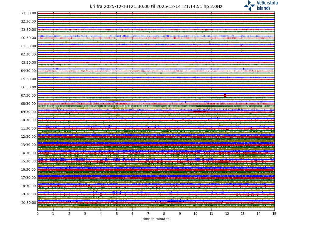
Perhaps we’re seeing some new/different faults developing, or a new dike may be forming?
FYI, drumplot link.

Can’t post the link for some reason.
Oh well, I’m sure everyone has the drumplots links bookmarked.
You posted an image link and WordPress automatically publishes is as an image. An automatically updating image that is. Better to post schreenshots if you want to look back at it later. Use https://postimages.org/ to upload. if you put spaces where the dots are in the URL, it will show up here; just copy and past to your browser and take out the spaces…
http: //hraun. vedur. is/ja/drumplot/drumplot/kri_highpass_2. 0. png
There is ground deformation caught on Langihryggur camera. Look on origin ground at right down corner between 15:00 and 15:20 frames.

Interesting.
To be hideously boring: Might it just be heat from the lava shimmering the camera view?
I don”t think. The ground is clearly waving, It can be due to subsidence above the dike which is located under this lava field with 200m offset to fissure as its written in Albert article.
Between 15.00 and 15.20 everything moves.
http://brunnur.vedur.is/myndir/listi/webcam_langihryggurN.html
No idea if quake, optical, smeagol….. I bet camera effect
It could be focus changes due to varying temperature. That can change the appearance of the edges of the field
A have taken a look on another camera. http://brunnur.vedur.is/myndir/webcam/2021/05/03/webcam_langihryggurNV.html?
Also there is similar effect at 15 20 but must thinner, only under the cloud. A hot gases of 15 10 volcano fires are heading with blowing the wind toward first camera then, so i think you are right.
IMO mentioned ground sinking in one area under the lava, but it wasn’t clear where a couple of days ago. It wouldn’t be surprising for more deformation to occur in that context.
Original RUV cam did take a look to the right at 16:19 (Southwest I think). There was more “hot spots” further up on the same hill.
(south-southeast) of course
Ol’ Smoky cam has failed. Perhaps they’ll upgrade it to super-duper HD for us!
I just woke up and now looked at the cameras. Is the black area on the hillside where the new fumeroles were spotted new? I don’t remember seeing this before. Oh the need to have a arcGIS program database to stay on top of fissure eruption changes.
I seem more steaming come from in front of the active cone, where we first saw the spattering about a week back. The new area on the smoking peat hillside is now intensively smoking, but only one camera seems focused on it.
It will be very interesting to watch the development of the smoking zones.
https://drive.google.com/file/d/1s-XB0XiyX3AA65Ilh_Kj-AmPw6qzhJiE/view?usp=sharing shows what I am trying to ask
“Smoking hillside” is new – see above! It seemed to start @10:00am UK time. Not sure about the other stuff.
Is this new? Good spot. Am just looking but it seems to be new: https://www.youtube.com/watch?v=-A182zOjRnc
Fumeroles or fire, that is the question. I noted those black areas, too.
The smell would be completely different, but with cameras that sense is missing.
It’s not fire! It’s steam/fumaroles. It doesn’t progress with wind and it’s totally white not black or grey…
From IMO
Re-evaluation needed of the size of the hazard area
5.4.2021
Updated 03.05. at 12:15
The eruption in Fagradalsfjall continues through one main crater. The active crater is the fifth fissure opening that opened in the area on the 13th of April. Since the 27th of April, the volcanic activity was characterized by continuous lava fountains, while the activity changed at around midnight on the 2nd of May, and has since been showing pulsating behaviour. These pulses have intermittent active periods of 8-12 minutes, with 1-2 minutes of rest periods in between. The active pulses start with a strong fountain activity, with fountains reaching up to 100-150 m above ground level, and some even higher. These pulses are very apparent in the seismic tremor from seismic stations in a wide area around the eruption site.
On Sunday morning, just after 6 am, the wind direction changed to slow easterly, and a few hours later smoke was detected in the southwest slopes of Geldingadalir. Possibly, hot pyroxene from the eruptive crater has been carried by the wind to the southwest of the lava field for about 300 meters distance and started a brush fire which can be seen on one of the two RÚV webcams.
It is not clear what is causing these changes in volcanic activity, but changes in magma flow, the chemical composition of magma/gas, or possibly changes in the volcanic conduit cannot be ruled out.
Considering these changes in activity, the size of the hazard area at the eruption site is being re-evaluated.
That’s not a fire, and today as other forum member told it started another steam point that is developing a lot. And this one is far from volcano. It’s steam!
It is very clearly the peat that is burning
It has moved up the hill and stopped in the places it started
https://www.themoscowtimes.com/2021/01/27/peat-fires-smolder-in-siberia-despite-bone-chilling-temperatures-a72747
Yes, I agree Luis, and when you watch a steam fumerole suddenly start up on the opposing hillside, you know that something hot is stirring around. Then you watch two more pop up within 5 minutes or so.
I am 99% certain that all this is not man-made and we need to take a very careful look at this.
In Yellowstone Park, visitors are not allowed to walk on areas which seem safe, because they might break through the carbonate or geyserite crust right into the scalding hot water.
I wish that Iceland had calibrated FLIR infra-red cameras, they would do much to show us what is going on.
And maybe those dull red hills which the satellite photo showed us, was not hot air.. perhaps those hills really are warm like that. It is worth a second look.
Yesterday, I was 80% sure it was something burnding/smouldering. Today I’m 99% sure it’s burning/smouldering. Before the RUV cam failed today you could clearly see it getting closer and closer towards the camera and leaving behind dark/black burned areas.
I clearly see it’s not a fire! It doesn’t move, it’s aligned, it don’t progress with wind and stays in the same place. Just put more or less steam. i’m 100% it’s steam!
There have been actual videos posted on here with the cameras zooming in on the peat fires… Not everything that burns gives off black smoke, quite a few things give off white or whitish smoke.
Additionally, peat has been used to smoke meat. Due to its slow burn rate and flavor it likes to give
“I love the smell of craters eating into the rim all day long”
In English the signs say “DANGER CLOSED” but I presume “HAETTA LOKAD” must mean “Perfectly Safe” in Icelandic as the locals just ignore them.
This finally gets them moving though
Ah – so THAT’s what cause the smoke to start emerging from the hill. All those signs hammered into the ground must have cracked the rock over the gigantic magma intrusion below!
I think it is sunburn
2 timelapses from the overview mbl camera, a slow and a fast version of the same time.
Yesterday evening to noon.
Fast version: https://youtu.be/K3ahebFDfug
Slow version: https://youtu.be/XBZ06LvsSaY
The view from Langihryggur will follow later. It’s not finished yet.
Also thanks for this article, which made everything a lot more comprehensible to me.
Again thank you for taking the time to do this,much appreciated.I have enjoyed watching your time-lapses
The lava river has pushed up part of the hill, Randall referred to this above. “is this new”
https://drive.google.com/file/d/1s-XB0XiyX3AA65Ilh_Kj-AmPw6qzhJiE/view
I played the Bob cam back it appears the hill is pushed up, a bit like a plug or dome rising. 13:30.
https://www.youtube.com/watch?v=-A182zOjRnc
I presume the heat and weight of the lava and voila a fractured hill.
Irresistible force meets immovable object…
It is a shadow. This is a very sunny Icelandic day and the contrast when this steep edge casts a shadow is quite striking
LOL I should have cleaned my glasses’
I see what you mean now.
I reckon it is been there all the time. The sun moving round highlights it differently during the day – try looking at it at about 9.00am or so.
The timelapse from Langihryggur (sounds like a throat clearer)
From 03h15 to 14h45.
Quite a bit was underexposed which I corrected for (better than I expected)
Because of the mechanical action I”d l’d call this one the Hell Machine in honor to Chad
(A little hell though)
https://m.youtube.com/watch?fbclid=IwAR0Xe4fJJV92Cz_S9C_gdOlR0hErLeDxsJ2Lm1Dhc6GAoaKb1iFV2duJBxI&v=UxPCZ76helM&feature=youtu.be
Webcam with a closer view of the main vent
I like when the fountains get low .. and it looks so fluid .. like fluid splashes
I’m so lost and confused with the vents opening and closing, cameras moving, falling over and moving again, etc. Where is (or was) the location of the original two vents (Smeagol & Gollum??) in relation to the currently active one.
down valley…the lowest
https://www.youtube.com/watch?v=7-RhgB1INII
there are the oldest twins. the active vent is on the left …a bit of it slope and smoke
Got it, thanks. that thing looks just like a little nub now. hard to think how active that was not too long ago.
On the wide view mbl cam, the two original vents are to the left of the active one.
Also still visible on the first RUV cam
https://www.youtube.com/watch?v=7-RhgB1INII
The active vent is smoking off screen to the left.
Get all the cams plus maps here:
https://maps.acme.to/gos/index.php
Tweet got a link to google maps. Current erupting vent(s) in red.
https://twitter.com/SilverRainbow/status/1388877281662210053?s=20
Thanks for that. Cameras keep coming and going. that’s a good resource.
That’s brilliant, thank you. I can orient everything now. 🙂
The original vents are next door, just south/southwest of the active vent. Those are the original vents in the RUV.is “Geldingadalir” camera frame. https://www.youtube.com/watch?v=7-RhgB1INII The currently active vent is just off-camera, to their left.
Most of the cameras are now facing from the other direction, looking right into the active vent. In those frames the original vents are to the left, but are not necessarily visible, being blocked by a large hill.
Above when the safety people were moving the onlookers back, they had an alarm buzzing alerting to bad air…. i’m sure that helped people to move back…. 😉 Clever… especially if the air was good. Points given.
Has anyone seen a timelapse of the smoking hill area? That might show the spread outwards of the fire more clearly.
Anyone else notice the possibility of a conduit going into the northwest rim of the crater? During times fountaining quiescence seems like lava oozes out up high. At first i thought it was just remnants dripping, now i’m starting to think there may be another pathway up through the built up spatter.
https://twitter.com/smarimc/status/1389321328306577412
Here’s a view of the volcanic eruption in Iceland from early this morning.
New 3D model is out:
https://www.ruv.is/frett/2021/05/03/glaenytt-thrividdarlikan-af-gossvaedinu
The burning area shows well. The two lava streams that meet at Meradalir are different colours. You can see the red helicopter on the surrounded hill, presumably dropping off staff to see to the instruments.
This is really weird – if I full-screen that 3D map, it actually beats like a heart!
Following Albert’s discussion of rifting and plate movement I took his map and recut it and move the one piece to match up with the Fagradalsfjall volcano.
Please tell me what you think, about the match up?
This whole thing is very interesting, as we can see changes in the land terrain.
https://drive.google.com/file/d/1hwelQ8_92yO-sfwiu499wwRK1t9eNLI3/view?usp=sharing
Before 35,000 years ago, the fissure line would have been offset the other way. On the left is my estimate of where things would have been when the shield formed and two possible fissure lines from that time and the right shows where those features are now.
https://imgur.com/a/Uu4hy28
Can this be deleted? Somehow got duplicated.
Before 35,000 years ago, the fissure line would have been offset the other way. On the left is my estimate of where things would have been when the shield formed and two possible fissure lines from that time and the right shows where those features are now.
https://imgur.com/a/Uu4hy28
Thanks for pointing out to me that the offset is the other direction. Appreciate the correction.
The bottom part is moving east. To match up, you need to move that part west (left). Otherwise it is showing the future rather than the past. Also very interesting!
Yes, indeed.
On the RUV Geldingadalur cam, I’m seeing little pinpoints of light coming and going in and around the fumaroles/burning peat. What on earth are they from? It’s kind of like when we’d see the rescue rangers/tourists torches come and go. Any ideas? It’s hardly people down there although I’ve just seen a chap walk past the cam.
Indeed. I guess it is just the burning stuff. Or a simpler explanation: dwarfs?
Peat burning. The question is: What set it alight?
I think radiative heat from the vent must have set it alight.
In the Reykjavik Newscast #100 Valur mentions the strong heat he feels as he stand atop the ridge overlooking the eruption.
The area with the burning peat and other plant matter must have dried out and then started to burn just from the constant heat of the eruption.
Makes me wonder how well / how long that webcam will hold out. Looks like it’s getting roasted…
I have some questions (to all)
1. How does radiative heat cause smoke/steam/smog to issue in linear directions? We saw long rows of burning peat on the hillside, the mbl.is cam swept it
2. How does radiative heat cause fumoroles to suddenly pop up when the infra-red is orthogonal to the surface (at right angles). I saw 2 fumeroles pop up on a hill a long ways from the active vent
3. How does radiative heat cause SO2 smoking of vents north of the active cone?
We really need to be asking more scientific questions.
p.s. There are more questions which need answering.
Depending on wind direction and how high the crater is throwing the lava, those 5 – 15 cm across lapilli that have been observed could be a source of ignition. Specially if the radiant heat from the volcano has dried out the moss and peat
Taal is seeing more ‘Volcanic fluids” exit the system more consistently with continuation of the background tremor for 4 weeks now. I am starting to think Taal isn’t finished from last year, both volcanic tectonic earthquakes and tremor pulses have almost stopped in last few months. Tremor is just continuing on and on with more fluid leaving the system. The only earthquakes that haven’t stopped are low frequency earthquakes which could indicate a variety of things. If someone knows where I can look at the seismograms for Taal, I would like to feast my eyes. The deformation is actually pretty interesting. The NW and SE side show completely opposite trends
https://comet.nerc.ac.uk/comet-volcano-portal/volcano-index/Philippines%20and%20SE%20Asia/Philippines/Taal/S1_analysis
We all would like that, but unfortunately all Phivolcs seismograms are under lock and key since the last eruption…
Taal’s eruptions usually come in instalments stretched over several years. To get an idea, you’ll find a nice description of the events in 1911 in the National Geographic of a year later.
https://avalonlibrary.net/National_Geographic/National%20Geographic%201912-04%20023-04%20Apr.pdf
Thank you for the article, the eruption at st vincent wasn’t enough for me, I need a VEI 9 to fully satisfy my explosive desires.