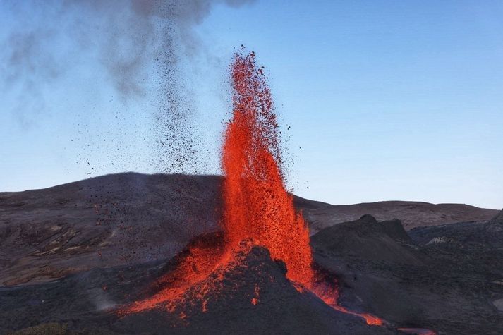
This is quite an eruption, with surprises with every new turn of events. It is an unusually tourist-friendly eruption: conveniently located, small, non-damaging (except to the owner of the land) and spectacular. It does appear that not all tourists are as friendly to the virtual tourists, judging from the antics going on in front of the cameras, but that is what it is. Even the local foxes have been photobombing the eruption.
It is very notably a dike eruption. It started out as a dike several kilometers long, forming at a depth of 6-7 km and growing upwards towards the surface. A whole series of cones have formed along a kilometer-long fissure where the dike reached the surface. For a long time multiple cones would be active simultaneous, but the eruption has finally gone conventional with fountaining and effusion only from a single cone. The cones have shown a notable tendency to go double, with two lava exits close together along the line of the rift. In each twin, the cones were acting fairly independently. From the distance between the twins, we can estimate that their lava feeds separated perhaps 50-100 meter below ground. This is not an entirely stable situation, and over time one of the twins will become dominant and finally exterminate its sibling. That indeed happened in all sets of twins. The surviving cone too has extinguished its sibling.
We might have expected the dike to reach the surface at the lowest point along the dike. To some degree this happened as the eruption started in a valley. But strangely, the eruption avoided the lowest ground in the valley and it first erupted on top of the only hill within the valley. When that wasn’t enough, it went for the higher ground next to the valley. It never extended into the much lower ground further north or further south, on either side of Fagradalsfjall. There was a bit of anti-gravity about this. Why was this? Clearly, the road from dike to fissure was not entirely straightforward.
To making of a dike

A fossilized dike. Source: wikipedia
How does a dike form? Obviously, magma gets in between the rocks underground and slowly pushing them apart. The dike extends both upward and sideways, and eventually becomes a wall which can be kilometers long and tall, but only a meter or so across. It is like a very large sheet of paper, slowly making its way vertically into the crust.
Where does the magma come from? There are two parts to this question: where was the magma to begin with, and how does it get to the dike? As for the origin, the magma can either make its way up from the mantle through a conduit (as seems the case in Reykjanes), or it can come from a magma chamber that is already in the crust (as was the case in Holuhraun). That magma chamber is in most cases (but perhaps not always) located underneath a central volcano. In both cases, the magma feeds the dike from a particular entry point, and the dike grows sideways from there. If the dike is fed from the mantle, then it is also possible that there is no single conduit, and that the dike is fed from below along its entire length, but this has not been observed in practice. As far as we know, a dike starts with a bottleneck.
Why does the magma form a dike, rather than a conduit up to the surface as it does in any normal volcano? This is the all-important question. Dikes form if there is some weakness in the land. Volcanoes grow on strong land. Long-distance dikes feed on weakness, on land divided against itself. They grow best on rifts.
Let’s look at two examples. The first is, of course, Hawai’i. It has impressive, in fact world-leading, volcanoes. ‘World leading’ can sometimes have a rather subdued meaning in the US. For example, the ‘world series’ is not quite what it seems as only teams from the US and Canada are allowed to take part. The ‘world’ is not allowed to play in the ‘world series’. That’s just not cricket. But Hawai’i can and does compete with the rest of the world. Its top-heavy volcanoes are riddled with rifts, and many eruptions come from dikes following those rifts. This happened in the Leilani eruption of 2018, from a rift which was tens of kilometers long. Many of Hawai’i’s rifts follow the line of flank failures on older volcanoes. If you stand on the shoulder of giants, you also inherit their problems. The weakness in Hawai’i is very much self-induced, a consequence of the immense size of its volcanoes.
The second example is Grimsvotn. For such an impressively erupting volcano, it actually looks a bit small. Bardarbunga is far more imposing. Why is this? Grimsvotn is a child of the spreading rift that bisects (possibly quadrusects) Iceland. The rift forms a line of weakness, and it provides the magma with a tempting escape route. Grimsvotn is a young system that recently (geologically speaking) formed on the rift. It does not have a strong a magma chamber, its summit eruptions are small (although very frequent) and most of the magma goes into the rift. Laki stole its magma from Grimsvotn, either directly or by intercepting the supply. ‘My volcano is my castle’ does not work if you built the thing on a rift.
Bardarbunga once also formed on the rift but it is an older system and it has moved with the times. As the spreading rift spread, it took Bardarbunga with it and over time the volcano slowly migrated away from the rift. This made its magma better contained because it is now further from the weakness of the rift. Not perfectly, though: often its magma chamber will spring a leak, the magma will find its way to the rift, turn north or south following the spreading rift, and produce a fissure eruption far from the embarrassed volcano (who, me?). This happened in 2014. But a decent amount of magma remains confined to its magma chamber and this produces summit eruptions, or otherwise just pushes up the volcano. (Much of the growth of a volcano happens underground. Summit eruptions have their role but don’t do all the work.) So Bardarbunga grew large, while Grimsvotn with its much higher volcano-metabolism remained smaller. One day Grimsvotn too will find strength away from the rift and grow to become a giant. And Bardarbunga will have moved too far from its magma supply, and decline.
So you have magma, and you have a rift. What happens next? The magma finds it easy to push in the direction of the rift. This pushed the rocks apart in a direction they want to go anway, because it is the direction of the rifting. The magma is pushing at a nearly open door. Going in the spreading direction, perpendicular to the rift, is much harder. That requires pushing the rocks in a direction they do not want to go. Magma, as a liquid, always takes the easiest path. So the magma prefers to move along the rift, not perpendicular to it. That happens both in Hawai’i and in Iceland. In the right circumstances, the magma can travel unopposed for tens of kilometers – but only along one direction.
When a dike begins to grow, it tends to follow the line of the rift. The growth can be followed quite easily, because of its earthquake activity. The tip of the dike has to break the rock apart, and this gives a lot of small shakes – almost explosions. While the dike lengthens, it may also grow thicker, but this is mostly a silent process which does not cause earthquakes. It does not involve new breakages, just widening a crack that already exists. So while earthquakes detect what happens at the ends of the dike, the centre moves quietly and secretly.
So this explains how a dike grows long and wider (‘wide’ is the wrong word though for something that is 10,000 times longer than it is wide). How about moving up? After all, a dike doesn’t do much unless it can reach the surface.
It turns out, up is also a hard direction. Gravity complains, and when gravity has the weight of 5 kilometers of rock behind it (or above it), it is hard to go against it by moving up in the world. It is not as hard as going perpendicular to the rift, because going up pushes the rock in the spreading direction it prefers to go, but it is much harder than going along the rift where the weight of gravity does not work against it. That magma may have some buoyancy which gives a bit of a push upward, but it is still hard. So the magma can move in three directions, but they differ in difficulty. Easiest is horizontal along the rift, harder to move vertical, upward, and impossibly hard to move horizontal but in the direction of spreading. This is why dikes become like sheets of paper, and why this only happens where there is a rift to give a preferred direction.
In the absence of a rift, all directions become hard. Magma does not find it easy to move against an undivided land. That is one reason it collects in magma chamber: it is hard to get out! But physics still acts, and physics says that in such cases it is easier to move sideways than upward. In such a case it forms a sill, a horizontal dike.
As an aside, comparing Reykjanes to Vatnajokull (Grimsvotn and Bardarbunga), one thing immediately stands out. Dikes in Reykjanes are only several kilometers long, perhaps up to 10 kilometers, while Bardarbunga’s dikes can reach over 100 km from the volcano and Grimsvotn, in spite of having quite an immature rift system, also has a long reach. There are two reasons for this difference. One, there is much more magma available in Vatnajokull because it receives more mantle heat. Ten times more heat should give ten times more magma and this should allow for ten times longer dikes, all else being equal. Second, there isn’t a clear spreading rift in Reykjanes. Instead, the rifting is taken up by numerous mini rifts, located along the Reykjanes fault line. As a result, eruptions in Reykjanes are rarely more than a few kilometers from the central fault.
The topography of the surface began to play a role. For there are dungeons and dragons here, or rather, valleys and hills. Where there is a hill, kilometers down there is more weight to carry. This affects the magma dike. To understand how, we need to go back to Holuhraun.
The Holuhraun dike
The Holuhraun eruption was fed by a very impressive dike which did not play according to the rules. It ignored the straight line and followed a roundabout route. First it went east-southeast from Bardarbunga. Then it waited, and changed direction to north-northeast. There were several more changes of direction. Why?
The answer is that the direction a magma dike takes is a combination of the spreading axis and the local topography. The basic principle is an easy one: magma will always take the easiest path. This is, the path that requires the least energy. The energy is used for two things: pushing apart the rock, and pushing up the ground above the dike. The energy needed for the latter should not be underestimated. A 4-kilometer deep dike carries 12,000 tons above every square meter. Pushing this up requires a lot of energy. Pushing up the ground is easier when the ground is lower, so the dike prefers to take the direction where the ground slopes down steepest.
What if this is not the direction of the spreading axis? Then the dike will find a compromise: it will go into a direction which is not quite the spreading axis, and not quite the lowest direction, but is the most efficient. It is called the principle of minimum energy. We can calculate at every point which direction requires the least energy. And indeed, the dike took this direction at every turn. The initial ESE direction was down the slope of Bardarbunga. It reached the rift at the saddle point where it turned north. Now it followed the rift direction in general, but with various deviations. This is described by Sigmundsson et al, Nature, https://www.nature.com/articles/nature14111.pdf

The Holuhraun dike
The plot of the rift shows these changes of directions. The coloured circles below indicate at each these location the energy required for evert direction. Red is high energy, blue is low. The dike always took the blue direction. The principle of least energy really works. Magma does not like wasting energy.

Dike energy diagram. Blue indicates lower energy needs
While growing in length, the magma also tried to rise, driven by its buoyancy. It was a slow process, but once an opening had been made, the dike did not progress further but instead used the easy way, to the exit. The last stretch where the dike begins to feed the surface eruption is called the feeder dike.
Fagradalsfjall
So this is how the Geldingadalir dike (the name has a ring to it) formed. The magma quickly moved from the mantle through the lower crust, either following or triggering the series of earthquakes along the main fault. In the upper crust, 7 km deep, the magma began to move sideways, horizontally along the spreading axis. Unusually, in Reykjanes the spreading axis does not run along the main fault but goes off at angle. So did the dike. The earthquakes traced the tips of the dike, which as expected moved towards the south coast in one direction and towards Keilir in the other direction. The earthquakes gave the impression that the two tips of the dike were primed for eruption. But that was misleading. The tips of the dike remained at a depth of 4-7 km. Instead, most of the magma that entered the dike was used to bulk out the central region. This bulking up was aseismic, although not invisible: the growing dike was seen on the interferograms which showed local inflation and extension, and those indicated where approximately the actual eruption would take place. Of course, hindsight is always 20/20.
The Geldingadalir dike feeling its way towards Keilir was small, but it followed the same physics as the Holuhraun dike did. The map shows the line of earthquakes which traced the dike. I took this from a plot showing the locations of earthquakes between Feb 24 and March 12: https://twitter.com/krjonsdottir/status/1370280535050878980

The dike is shown by the orange line. The location is not exact but is taken as the approximate midline of the earthquake activity While moving north and south, the dike made a small change in direction, and at one place going south there was a bifurcation and the dike (as traced by the earthquakes) backtracked and went into a slightly different direction. The point of bifurcation is uncertain: it might be a bit further to the south.
One would expect the dike to follow the spreading axis. The spreading axis in Iceland runs nearly north-south (about 10 degrees east of north). However, the land itself is also moving. If you take the direction relative to the (moving) plate boundary, the axis becomes more eastward, and follows the line of the obvious volcanic ridges on the Reykjanes peninsula. This direction is shown by the blue dashed line. The northern section of the dike indeed closely follows this direction. The land here has only a small slope towards the northern coast. The cost of gravity varies very little with direction and the dike is completely dominated by the spreading axis. But this is not the case underneath the mountains of Fagradalsfjall, and here the dike chose a different direction. It avoided the peaks of Langholl, Kistufell and Storihrutur (where the cost of gravity would be high) and followed the lower ground in between. The peaks here are far smaller than the mountains of Vatnajokull and the effect is less than seen in Holuhraun. But topography still matters.
Sometimes a dike takes a wrong turn. One of the two southern branches ran into a high ridge, found no way out and terminated. There was not enough energy to continue in any direction. This caused a bifurcation: the alternate channel found a way into the deep valley of Natthagi, and ended there. Towards the north, the dike ran into the large cone of Keilir. This also was an unsurmountable obstacle, and the dike could neither go through or go around. It terminated here.
Underneath the mountains, the direction is always a compromise between the spreading axis and the topography. We can largely understand why the dike took the directions it did. The only surprise is that it crossed a small ridge but this ridge is quite narrow.
The best route also depends on where the dike first formed. If it had formed along the southernmost segment, the preferred route would have been directly into Natthagi and Meradalir. If it had formed north of Kistufell, it would have gone only to the north. The most likely place for the first magma intrusion is therefore along a line between Kistufell and Langholl, to a point left of Meradalir. This is indicated by the blue oval.
The dike and the fissure
How does this compare to the fissure? An excellent Landsat shot of the series of cones (and lava flows) has just appeared, showing all 6 cones.

The series of cones follows the direction of the main dike quite well. However, the fissure is offset to the west by about 200 meters. I measured this several times but could not get the mid-line locations to match. Between the deep dike and the surface rupture, there is a slight tilt. This seems problematic: it is a principle of geology that dikes are vertical and do not tilt. Perhaps the dike is not quite at the central line of the earthquakes, the dike has a few more small but unrecognized changes of directions that bring it in line with the fissure, or the fissure is not actually the top of the dike but there is a tilted conduit between them. Most likely, of course, is that I did not get the measurements quite right.
There is one further surprise. The dike will find it easiest to erupt at the lowest point, where there is the least amount of rock to melt through. The eruption happened close to the point where the magma came up from the mantle. Meradalir would have made a good eruption point, being a deep valley, but the dike bypassed this. The next lowest point was the valley of Geldingadalir where indeed it erupted. But in this valley, there is a small hill. Strangely, it erupted near the top of this hill. The later cones similarly avoided the deepest valley and went for the higher ground to the north. This remains unexplained. For some reason, the hill was a weak spot which allowed easier access to the surface for the feeder dike. We will come back to this.
The Reykjanes fault
The Reykjanes fault was crucial to the development of the dike. This was the fault that initiated the immense swarm of earthquakes which announced the eruptive intent. It gave way in several M5 earthquakes. This fault is mostly a transform fault. The south side is moving east relative to the north. The interferogram shows the movement beautifully. Red (eastward motion) delineates the fault perfectly.

Let’s put this on the map. Here is the map of the dike and fissure, on top of the digital elevation model. The black line shows the Reykjanes fault, as traced by the area where the surface moved to the east. There are slight offsets along the line but I have ignored those. The white lines shows the region of earthquake activity along the fault in the weeks leading up to the eruption. These were largely aftershocks of the main earthquakes where the sides of the fault made small adjustments with minor failures. The dashed white line shows the location of an earlier series of earthquake which happened in 2017. The earthquakes were seen in an area north of the surface motion.

The fissure is closely related to the fault and the fault earthquake zone. The fissure terminates on the fault itself and did not cross the fault. This eruption belongs to the North American plate and did not manage to cross into the European plate. Interestingly the dike had no problem with this and happily crossed over. It seems that at depth (hotter rock) the plate boundary is easier to cross.

The circled feature is close to where the Reykjanes fault is located, and perhaps traces the surface rupture of this fault. Source: Lughduniense
The second point to note is that the length of the fissure largely coincides with the width of the fault earthquake zone. This eruption occurred where the dike crossed the fault crumple zone. It made use of the weakness of the rocks in this area.
This immediately show the importance of the Reykjanes fault. The fissure similarly began exactly at the fault line, and extended northwards from there.
That hill

The early days: the cone on the hill
When the eruption began, the first fissure followed the ridge of a small hill in the Geldingadalir. The origin of this hill was not clear. It was not a result of an earlier eruption. It may have been glacial.

Step-over faults
However, the location close to the Reykjanes fault suggests another possibility. The Reykjanes fault may have step-overs, where the fault consists of segments which are slightly offset. This is very common for faults that are young and still in the process of organizing themselves. An offset in a transform fault can cause conflicting movements. The step-over can cause either cause compression or extension in the area in between. In the first case, a pressure ridge can form a small hill form in the area of the step-over. I speculate that the hill of Geldingadalir is (was) a pressure ridge: it is the location of the transverse fault where at one time a small step-over occurred.

Pressure ridge along the San Andreas fault. https://www.flickr.com/photos/rwolf/48004993242
Pushing this speculation a little further, the transverse crumple zone may have given the magma the easier pathway to the surface for the feeder dike. This would explain why the fissure ran along, an in fact started on, the ridge of the Geldingadalir hill.
Where pressure ridges occur, you can also find sag pools, or small basins, where the fault pulls the crust apart. Was Geldingadalir itself such a depression? This is becoming even more speculative.
Extension
The Reykjanes fault is more than just a transform fault. There is also a bit of extension here, a little bit of spreading. The sides of the fault slowly pull apart. If I am allowed to speculate even further (we are getting on very thin ice here), the notably deep valley of Meradalir could be a result of this extension, as a small pull-apart basin approximately along the line of the fault.
Can I see any evidence of the movement of the fault? That is notoriously difficult. It means finding features in the landscape on either side of the fault, and matching them up. But landscapes evolve and the two sides may not look alike any more.

I can attempt this for the ridge that separates Meradalir from Geldingadalir. It continues across the fault but the appearance is quite different on either side of the Reykjanes fault. Perhaps this isn’t the same ridge? There is another ridge a bit to the southeast which looks more like it. If I shift this ridge according to the spreading direction and transform movement, the two ridges line up fairly well. The offset is some 700 meters. Assuming an average movement of 2 cm per year, this makes the ridge 35,000 years old. The offset nicely delineates Meradalir which becomes a small pull-apart basin. The ridge would have formed during the depth of the ice age.
I can push this further. On the south side of the fault, there is an eroded plateau which lies just south east of the ridge. There is no such plateau on the north side of the fault. There is however one on the west side of the area: the high plateau of Fagradalsfjall. Could that be the same plateau? In that case the offset is around 2 kilometers. The age of the plateau would be 100,000 years. Was this a shield eruption? The lack of ridges would imply there was no ice when it formed. And indeed, the time is close to the last interglacial when Iceland was ice-free.
This is deep speculation, in severe need of data, even if those data may well show it to be in error. Lots of handwaving involved! But the ages make sense. The Geldingadalir eruption came in an old landscape which had seen little or no volcanic activity for tens of thousands of years. It is a unique event. We are very lucky to have seen geology in such action in our life times. The last time this happened, we were still into cave paintings.
Albert, May 2021


Busy day.
All this talk of peat and grass bogs has got me wondering if there are any palynology studies around. I really hope some soil samples were taken from Geldingadalir before the lava swamped it all. That would give an idea of the peat depth.
FYI the climate and latitude means that biological processses take much longer; both photosynthesis, and degradation/breakdown of organic materials. See the graffiti damage made to the moss hillsides during WW2 that can still be seen today.
Ye gods I wish I was still young enough to go dig a few soil sample pits.
I’ve also had a brief look at the Langihryggur N camera. It struck me that one of the most gaseous times was early evening. I wonder if humidity levels and dew points may have a bearing on the intensity of the porous steaming ground?
You have an excellent point!
There have been times I’ve noticed the vog, or smokes, above the lava and adjacent land become thicker. I put this down to temperature changes, like cooler air causing the gases to condense swiftly.
I am sure you are quite right and humidity/dew point variations cause this.
You wish you were still young enough. Me too. I thought about reading geology. Next thought: Field work. So, studying it privately.
Unfortunately I took a joint physics/chemistry lower qualification, which excluded me fromtaking chemistry at the next level which I needed to go for a geology degree. So I plumped for the next best thing, a modular Geography degree where I could specialise in the physical and biological aspects, reading a double major in Landform Science and Environmental Biogeography. My dissertation was on the palynology of a British lowland heath, to help establish that this technique could be applied in other stratified deposits apart from peat bogs. It worked, as I got back to the upper Dryas in one soil profile. I wonder if the work ever ended up in a publication.
Every feed is behaving badly again tonight. RUV1 is out of focus. MBL is working normally, but not the Youtube stream used to watch it, which is having bandwidth issues again. Same symptoms as before: keeps getting stuck buffering, and never shows even a bit more video unless the seek bar is used and then “live” clicked, or the page reloaded, to force it to reset. And after it’s been running for a couple minutes tops, and often much less, Youtube gets stuck buffering again, even when there should be plenty of bandwidth at my end for the selected quality level, as if there’s not enough at google’s end.
Can’t tell if there’s still fumes seeping out of Norðri with RUV1 out of focus like this. No idea about vent 4 either, which was smoking a bit last night.
AFAICT no qualitative change in the eruptive activity at vent 5. Quantitatively, it may be that the overall period of the cycle has grown shorter somewhat. It’s hard to say. Clearly though the whole system underwent a Hopf bifurcation a few days ago, which may mean it’s being driven harder by the underlying forces.
One gets the feeling that anything might happen next. Every few days since this started there’s been some major new development. Norðri suddenly growing much larger to become the dominant vent; the large chunk of cone breaking off and rafting away; new fissures opening x4; the fissure 5 vent growing much larger and becoming dominant; a similar chunk break-off there; and then the pulsations. Rarely has this been stably doing the same thing for even a single full week before some significant change. I wouldn’t put money on the current status quo holding out for more than another day or two, if that.
Google’s stopped stuffing up the mbl stream; unfortunately, sometime in the wee hours of the night they zoomed that one way, WAY out. Factor of five or six. Not much detail of the eruption vent available there anymore. The ruv1 one remains no better, not due to zoom but because some twit forgot to take it out of “macro” mode after using it to look at a pretty flower or something. It also seems that both cameras are now on something of a drunken tilt — check out the horizon in ruv1. Quick, before the weather changes.
The smoldering hillside, visible in ruv1, is down to a few isolated patches. It does look to me like a brushfire burned its way up the hill gradually, and then mostly went out. No evidence of fissures or vents of any kind there in my judgment. The mystery is why it waited until yesterday to catch fire instead of, say, doing so when that huge wall of black lava first arrived right next to it weeks earlier, still red-hot and steaming. I doubt it was ejecta from fissure 5. The hillside in question is easily five times as far from the center of the vent as the farthest I’ve ever seen it drop spatter from its highest fountaining outbursts. My money would be on human carelessness as the cause.
I think the camera is not out of focus, but part of the lens is covered with some deposit, moisture or otherwise. It is sharp on the right but not elsewhere. Cleaners needed, perhaps
When the lava first arrived at the foot of the smouldering hillside area it was still early spring – frequent rain and snow showers, with repeated snow cover/ snow melt episodes. The ground and moss would have been damp, if not wet. most of the time ( you could see steam at the foot of the slowly advancing lave front. I would guess that only recently has the ground/ moss dried out sufficiently to sustain combustion for several hours. It would be interesting to see the advancing lava front in Meraldir to see what happening ( if the vegetation is similar)
https://www.youtube.com/watch?v=c_vnsLQBVlY
🙂
Thank you Albert. I can make some sort of sense of what s happening now. (The usual Human reaction of looking for patterns!) There has been some hard work put into this post. It’s certainly appreciated here.
I wait now for the next instalment of The Saga of Ballareldar, for indeed this is no longer a mere ballad but a true Saga ( A long story of heroic achievement, especially a medieval prose narrative in Old Norse or Old Icelandic (sic) )
What a complex system this is. I so agree that we are lucky to be able to document this. Future geologists will give thanks for our data and speculations.
What, if anything will happen next? As in any science, the absence of expected data is as important as full blown action.
Like that line- ” the absence of expected data is as important as full blown date” .We may wish as much as we like in regard to the Ballareldar eruption what happens next or ought to happen-in the end we’re luckly what we have -this small gentle moody eruption of smoke and mirrors.
From Volcano Chaser https://www.facebook.com/volcanochaser/posts/131222589058887
“Also, the largest debate regarding the eruption during the last 36 hours has been focused on the white smoke appeared on the southwestern side of Geldingadalir yesterday morning.
That was NOT produced by a potential new fissure opening up, but by still hot volcanic scoria up to 10 cm large that are falling downwind even 500-600 meters away from the vent. Those fragments are igniting the moss on the sides of Geldingadalir and the fire has been spread all over the area by the high winds. I made an inspection of the area yesterday specifically to be sure of this.
More details about it in the 4th pic of this gallery.”
“I made an inspection of the area later during the day and I found the evidences I was looking for:

– A lot of volcanic scoria on the moss.
– Moss burning (pic below). It burns really slowly and persistently and the smoke production is higher with slow combustion. This also contributes to keep the fire on which is spread in a wider area by the winds.
– The strongest fountains are up to 350 meters high and the wind is strong enough to push 10 cm large lava fragments, even 500-600 meters away from the vent.
– Volcanic scoria fallout also on the hill south of the erupting vent (on the other side of the valley), triggering more fires on the moss. I’ve witnessed the whole process live.
– There are no cracks, fissures or other geological evidences that suggest that this has been produced by magma pushing under the ground.”
Great work- bingo-mystery solved!
Thank’s! It’s soo strange this linear non progressive fire…
It makes more sense when you consider how moss and peat burns, compared to a grass or brush fire which most people are much more familiar with.
Grass and brush fires burn on top of the ground, with flames which are caught and fanned by the wind. These fires can move extremely quickly through the terrain, given the right conditions.
Moss and peat, on the other hand, burns *in* the ground, and is a smoldering fire with little to no flame. Such fires are thus not affected by winds nearly as much and they tend to move very slowly.
They can also burn very deep, and because they burn slowly they don’t need as much oxygen to keep going. It is not uncommon for a peat fire to be extinguished at the surface, but deep down it will keep smoldering and can light up again even weeks later.
Thank’s! I’m not used to it so that’s strange for me…
here in Alaska it’s not uncommon for burning muskeg to over winter and reignite in the spring. Kinda like this moss and peat but i suppose the actual ground cover is more like Alaska’s. It would be interesting to know more about it.
Quite good, second pic great.
Picture of arctic peat fire in this article, similar:
https://www.nature.com/articles/d41586-020-02568-y
Well that’s put all the theories (including mine) very much to rest!
Thanks Bjarki for bringing the information over!
(Grumbles: so my theory about Icelandic Volcanologists hammering danger signs into the hill and cracking open the magma intrusion has to be discarded. Hmph!)
Over at the volcanocafe facebook page, Marco Di Marco, Volcano Chaser, has posted his own eyewitness report about the burning hill side. He went there in person to take a look and the entire area is littered with scoria from the high fountains – some as large as 10cm. The smoke clearly comes from burning moss and nothing else. Included in his post is a close up photo of the burning moss. He gives a very detailed description in the description of that particular image.
https://www.facebook.com/groups/189749654542072/permalink/1755578997959122/
Too slow, Bjarki beat me to it 🙂
Does anybody noticed a new flow on this cam from about 05:23am ?
What I appreciate in the second part of the piece and also in Carl’s piece before is the question marks, having ideas, stating that, so far, they are partly speculative. Imagination seems very important to me in this field. Then afterwards there is the hard work for – like Carl said – mostly PhD students to work on proof.
Both pieces are brilliant.
A MOR is a neat place. You can send a bathyscape down and investigate it. Under Iceland it seems more chaotic.
“What I appreciate in the second part of the piece and also in Carl’s piece before is the question marks, having ideas, stating that, so far, they are partly speculative.”
Ditto.
There is a strong argument for imagination and creativity in many scientific fields. Without it, it would take much longer to come up with possible answers. Imagination allows you to think of things, that can then be tested, without hours of looking for patterns first.
Exactly.
https://twitter.com/rockhardIES/status/1389507618322931715
Watching (from a safe distance, with camera zoom) the slow and steady advance of incandescent rock. A team from
@rockhardIES
were back at Fagradalsfjall collecting new samples last Saturday, but not from this part of the lava flow!
https://twitter.com/BSteinbekk/status/1389388300323074050
Few hours ago I flew into the crater, and back. Full video dropping tomorrow.
Looking at it, the wonders of nature’s art I thought!
Can’t wait to see this video!! WOOOOOW……..
Interesting view, just a small pond remaining in the crater in the quiet periods!
And i think the time between explosions is growing…
Critical for safe in crater flights…..
Cool about time! Drones are the laparoscopic eye for the big nature picture!
Don’t know if this one has been posted, 360 drone footage from earlier in the eruption (just move drag the mouse around for the 360 views)
Hi, long time lurker. I thought this heat map might be worth investigating. It’s not that well defined, but it does have some interesting features.
https://zoom.earth/#view=63.892908,-22.250696,13z/layers=fires
Well. From pure deduction I would say the dots cover a “general area” rather than the exact spots of heat from cooling lava and the active vent. I looked at the map and a couple of small spots showed up in the North Sea. They are – most lightly – from flaring in the british sector (it’s banned in the norwegian sector), but nothing else showed up. So the theshold for those red spots to even show in the map requires quite some heat. Otherwise there would be lots of them from marine traffic (large ships) that have bunker oil exhaust temperatures well exeeding 100 deg. C at the cap of the chimney. And ships do not show up in the map. Maybe the treshold is 3-400 deg. C. ? Would be interresting to know btw.
Given that – we would have known from icelandic news by now if the temperatures were that high (or higher) in the general area. Reports of hot feet, hot bottoms, failing eqipment, swetting Icelanders and so on would have surfaced. . Aka “debunked” one way or another. 😀
This comes from a satellite that is pretty good at picking out fires but does not have high resolution. It will see the active cones and the active lava flows, and probably all the recent lava flows that are still hot (meaning most of them). The google map seems to have merged more than one pass of the satellite with some errors in positioning. Good for picking out active volcanoes, less so for detailed maps of the flow
Good stuff as always Albert.
“When the eruption began, the first fissure followed the ridge of a small hill in the Geldingadalir. The origin of this hill was not clear. It was not a result of an earlier eruption. It may have been glacial.”
I’m pretty sure there is footage from the start that shows what to me looked like exposed bed rock at the top of that hill, right under the edge of the highest cone. It was on the side opposite from the MBL camera. Think that would exclude glacial deposits as a possibility, so your thoughts on it being a pressure ridge could be on the right lines?
Looked to me very similar to what we find e.g. west of Meradalir (M):
(from: https://www.maps.is)
What does this pulsing behavior with seismic signatures tell us about the eruption?
Is this a feature of a matured eruption, or just one of many phases it will cycle through?
Does it indicate the current cones eruption is stable? Or it is not stable and possibly ending at this specific cone?
Input appreciated as always.
-SD
Most likely it means this cone is reaching the end of its life. I would not dare to predict what happens next!
I would instead say that it indicates that there is a “cave” with the ceiling higher than the outlet that gas and lava fills up. this will then work like the engine of an old steam locomotive and the expanding gases will push the pulses in the crater. When the pressure releases, then new gas fills up the cave and as soon as it starts to move towards the crater we have a new pulse again.
So where is the “cave” then? I guess it was created by the closure of the old vents.
But, I don’t know, I am only guessing based on a bit of knowledge in thermodynamics and engineering from many years ago.
I did some plotting. Found an excellent tool, plotly, that you can use to export interactive plots as html. Here are all the quakes since a few days before the start of the intrusion, plotted in 3d. You can rotate and zoom as you like. The starting view is from northeast looking towards the dike with Keilir in the foreground. I tried to annotate different landmarks, but the annotations were not correctly transferred to the exported html, so I had to remove them.
http://stallannero.se/pix/2021/dike.html
There is an interesting void at 6km. We also see that quakes reach for the surface at three places: one is the eruption site, one is the southern end and the last is where the dike makes a turn. Maybe the part towards Keilir that is northeast of the turning point is not part of the dike, but simply the fault of the large quake that started it all, together with its aftershocks. Volcanic tremor was recorded first when quakes started going in the other direction.
Very nice! The reaching for the surface at waiting points was also seen at Holuhraun. When it changed direction, it typically waited a few hours to days. The heat spots under the ice cap happened in those areas. I would guess that this means that if the current eruption blocks, those two spots should be watched in case it makes a new attempt
The gap at 6 km is interesting. It depends how accurate the depth data is. There may be a reason that the recording system did not return that depth. Otherwise, a pre-existing magma dike at that depth, perhaps, or the earthquakes below are actually reflections of the boundary layer
The voids remind me a bit of an ant’s nest. I thought about it, if it might be an artefact of the system somehow, like the default depths that we see sometimes, but these are all manually verified quakes, so there must be another reason. A reflection sounds plausible. A magma body is another interesting alternative. Looks a bit like a sill. Or maybe it’s the magma transport path. Near Keilir the void looks like a funnel going down. That cluster of quakes has been very persistent since the eruption started and if the magma comes straight up from below and makes a horizontal turn there, there must be forces pushing on the rock which could explain the quakes.
I have spent a little too much time spinning this plot around now, so I’m not sure any onger if the quakes or the voids are more interesting…
Non volcano related:
https://www.youtube.com/watch?v=I1I-0PUhFmU
@14:52:12 – A red drone appears left of screen, out of control, falling across the screen and appears to crash off camera.
As a FPV drone pilot myself I’d say that’s normal flight behavoiur of a FPV-Quadcopter, he didn’t crash. About a minute later he’s flying in front of the crater.
https://twitter.com/gislio/status/1389590956303953920
The Grindavik soccer club –
@umfg
– just introduced their new backup uniform for players – the inspiration for the uniforms is the #Geldingadalur #volcano #eruption that is only 5km away from #Grindavik. Super cool video they produced to introduce this.
New smoke area…
That area was caused by another lavanado which sucked up a bunch of tephra and dispersed it to the now now smoking area.
‘Sparknado’?
WOW a big drevil just formed on side of volcano!
Have you got a screenshot of this ‘tornado’?
Good view on the close up mbl cam showing the twister dragging the tephra out in the field
Was this not posted yet? Amazing footage!
https://twitter.com/BSteinbekk/status/1389561588244418561?s=19
https://twitter.com/DJCManns/status/1389633246435160068
~10 minute timelapse showing gas emission and plume formation over #Fagradalsfjall, taken from Ægisíða in Reykjavík.
https://twitter.com/DJCManns/status/1389632845069656071
I would instead say that it indicates that there is a “cave” with the ceiling higher than the outlet that gas and lava fills up. this will then work like the engine of an old steam locomotive and the expanding gases will push the pulses in the crater. When the pressure releases, then new gas fills up the cave and as soon as it starts to move towards the crater we have a new pulse again.
So where is the “cave” then? I guess it was created by the closure of the old vents.
But, I don’t know, I am only guessing based on a bit of knowledge in thermodynamics and engineering from many years ago.
I like this theory! It makes a huge amount of sense.
Clever. Thanks for sharing this idea. Seems quite plausible.
From 18:08:50 onward big collapses…
“Giggle” translate I’m afraid… but might be interesting to some.
https://translate.google.com/translate?sl=is&tl=en&u=https://www.mbl.is/frettir/innlent/2021/05/04/hraunrennslid_med_thvi_mesta_sem_sest_hefur_i_gosin/
The last Pulse started at 18:18, it was last hour by far the strongest with the biggest outflow. And it lastet 40 sec longer than thr previous ones…
Lastet 4;35 min
A change in the Pulse???
Something brewing below?
Getting stronger as the main vent in first eruption wanes with longer gaps between fountaining.
Second system awakening maybe?
Tremor to the Sth West going strong since the main vent changed to this new fountain phase
It shows up on some, but not all of the nearby stations as well, but I hadn’t looked more recently to spot the increase showing up in the last 24 hours or so (KRI, expectedly, HEI less expected. Others to look at BJA, ISS and GRI, others I am unable to check sytematically). I was unable to see a pattern in the stations where it did and didn’t shown up, but looking at more stations may show more of a pattern, e.g. North American vs. Eurasian plate. Unfortunately, the image that IMO shared on Twitter doesn’t show the station names further east and the Tremor map is incomplete. Others with greater knowledge of where the stations are located by name may see more.
Sorry, I assumed that was FAF above, that is the closest one, followed by ISS.
https://www.youtube.com/watch?v=tFaz0blkYfs
“How dikes form their paths from the source to the surface
Professor Agust Gudmundsson
A volcanic eruption occurs when a magma-filled fracture, a dike or an inclined sheet, is able to propagate from its source (a magma chamber) to the surface. In this talk I explain how dikes/sheets choose among, theoretically, an infinite number of paths. I also explain how and why most dikes and sheets become arrested, that is, stop their propagation at depth in the crustal segment/volcano and never reach the surface to supply magma to an eruption. Being able to forecast the paths of dikes/sheets is of fundamental importance for hazard assessment during unrest periods and for understanding how volcanoes work.”
Interested in the pulsing I have been watching and saving the faf drumplots from the start.
This afternoon and evening I dis count the pulses per hour and wrote down the time between the pulses.
Ah, a bit of work more than I expected! Anyway…
What changes have there been in the fountaining over time?
02-05 the pulses started, first 10 hours 4 to 5 pulses/hour. After that the pulsing became more frequent and after about 18 hours since the start it has been quite regular. Past days, up til this evening there are mostly 7 to 8 pulses/hour.
Clockwork? No, not really.
The time inbetween pulsus vary a bit. Mostly it takes 7, 8 or 9 minutes to start a new cycle. But that is no rule. Sometimes it takes more than 20 minutes starting a new fountain. The cycles after such long pulse are remarkably shorter, 5 to 6 minutes. That’s why the figures /hour stay pretty constant.
The rest periods between the pulses are constant 2,5 to 3,5 minutes, really not much change.
I will try to make a diagram of the pulses and post it.
What is happening? My volcano knowledge is way off to write something making sense.
The view in the cone in between the pulses (twitter, scroll up please for the link) was surprising to me. Just a small, very still pond of lava, no (small) lake at all.
There seems no change in the periodicity of the pulses, so same habit as the waning activity as in Baugur/Holuhraun (pulsing slowing down after time, activity declining) is not there (yet).
The largest, most explosive fountaining was present in the longer cycles in the beginning.
I didn’t check if there is a relation long cycle – higher fountain past two days.
faf drumplot showing pulse pattern.

Credits IMO.
There seems to be more gas to me today as well.
That could be caused by a higher water content as noted in Barbara’s linked article below.
Article from today:
“Eruption’s New Behavior Explained”
https://icelandmonitor.mbl.is/news/nature_and_travel/2021/05/04/eruption_s_new_behavior_explained/
Lava lamp. With explosions
So one of their two theories is the same I had. Degassing into a space under ground and when there is enough gas, it will escape to the crater/vent and as the pressure decreases more degassing is done. 🙂
I am not completely clueless then….
Icelanders these days …
” 🎵🎶buzzzzzz happy drone flying … bzzzzzz
– Icelander .. ”lets fly it into that vent!”!
– drone .. NO!! No!! NO!! NOO .. SPLAASH!!!🌋 🔥 slurp Blub Blub bubble 🌋
Flying drone Bzzzzzzzzzz bzzzzzzz .. SPLAASH!!! 🌋
Dead
https://twitter.com/clarkdeirdre/status/1389662011831816198
Here is the latest graph with this updated data! This cute eruption at #Fagradalsfjall is slowly but surely growing with no signs of letting up anytime soon.
Just watched 21.55 to 22.02 on the k100 webcam looking into the active vent.
Has anyone noticed that it looks like the lava level is rising and falling? In the 7 minute time period I saw the vent move from a still pond with no glow, to an overflow start and run out again, then bubbling with small explosions like gas blurring up through the lava. It then slowed down and then calmed back to a pond with the over flow slowing and stopping. A rest for a couple of minutes then repeat.
It looked less like a fizzy drink bottle trying to release gas and more like just more lava being pushed up, overflowing and releasing what gas it had, then a pause, resettling and then another push.
Is that what everyone else is seeing? Does it suggest a pulsing feed, or just that some gap fills up, overflows and then it needs a bit of time to refill? Is this different to before because it looked more like a continuous flow before?
Question, questions questions!
It’s been doing that for a few days. Change in behaviour. It’s a lava geyser now 😆
It is very similar to Kilauea Iki, i do like all the theories here but I think most are needlessly complicated.
Basically there is lava ponded over the vent, and it is degassed and heavy. The weight of this is high enough to prevent fountaining and pressure builds, but also the heavy lava flows back down the tube and eventually this overcomes the plug and it blasts out. This is actually exactly like Strokkur, which is entirely pressure driven from its overlying pond and not a constricted conduit. That is a result of deliberately drilling it but the result is a geyser with rapid intervals of brief fountains, instead of long intervals with bigger fountains like at Old Faithful.
When you have a larger volume of denselava over the vent like the lava lake at Kilauea Iki, or the shallow magma body at Pu’u O’o, then much more pressure can build. Pu’u O’o erupted only once a month but its fountains also lasted hours sometimes days and erupted as much lava in 1 sitting as this entire eruption at Geldingadalir.
Thanks Chad, that makes sense. And I like the simplicity.
Just hadn’t noticed the (relatively) gradual rise and fall of the level reflected through the overflow speed before so thought it might have change behaviour again.
It does look like the pulses are coming in more even 2 mins on 2 mins off at the moment.
Well explained Chad- now have gained a better understanding of our lava geyser.
I still think that you have a degassing chamber in this case. Otherwise this wouldn’t have appeared right after the other vents stopped smoking. As I see it, the degassing chamber is a much simpler explanation than that the lava lake acts as a lid that blocks the gases. I think that the best counter argument against the lid is the short period, if it had been a lava lid, then the gassing should’ve been longer, especially as the fountains are so intense that they are shaking and stirring the older and the newer lava into more viscous fluid than what was there prior to the fountains.
I am no expert, but I still would bet my money on a chamber/void that collects the gas. The principle is roughly the same as the lid, but I think that you need larger lava volumes for the lid principle to come into play (less mixing of old and new lava, the new lava should have a “tube” through the new lava for the lid principle to work).
https://m.youtube.com/watch?fbclid=IwAR3QIm7MdFwtvmeYirZfEGFil2XZAqgsqlUsevlggGqtrG1iyhP-L44Vk04&v=UtsVgtt8RYc&feature=youtu.be
Closeup of the lava pond Inside
What the models have in common is an obstruction. The magma is not flowing as freely as before and the top is becoming stagnant, before sinking and overturning – whoosh. The models differ in where the obstruction is
Yes, I agree. My theory is to be compared with the air-lock of the sour. As long as the air-lock is there you have no smell (lava flow). The problem is however that the pressure is increasing with degassing in the air-lock and when it is flushed up-stream, then additional degassing is driving the process until the pressure is equalized.
And I do believe that we have a dyke like that after the closure of the older vents.
But I am still guessing. But I do believe that it is a good guess… 😉
I notice that the fountain ejects to the left first, very powerful and high, then continues to diminish in strength and sways to the right. After that some blub-blub to retract and repeat the cycle.
Regards from Holland,
Niels
Vent 2 is steaming again?
These pulses in the active vent are becoming extremely frequent.
Is this real ? A Lava Geyser seen from the Icelandic capital Reykjavík.
https://twitter.com/i/status/1389693273799905282
It’s real, only it’s being magnified by the zoom lens.
I can see the top of the tall fountains from my living room window in Reykjavik. Quite unreal to watch.
That is incredible to see. wow.
Yes, it is real. It is quite a sight and very surreal to see this while taking the dogs for the evening walk. 😉
RUV backside camera shows a suspicious glow in the old lava field. Can’t be from the flow of the current erupting crater. It’s not from a lava bomb either and certainly no moss fire. Is this still the old hot lava lurking? (Probably not) Or is there some hidden fresh lava flow beneath, maybe from one of the other vents above?
Screenshot:
Source (watch it during a lul in the eruptions): https://www.youtube.com/watch?v=7-RhgB1INII
I think almost everyone gone to bed who could answer your question. That lava you mentioned could be fed via lava tube/channel-just a guess.
The lava in that area is very deep something like 40 meters if not more, like the lava lakes at Kilauea it will take years to cool and its probably still liquid inside. It wasnt on the livestreams but there was a breakout going towards the southern end of Geldingadalir the other day. I would guess there is still some connection somewhere, maybe to the lava river where it goes past Bob it drains down, or the cone growing onto the lava has squeezed out some of the liquid interior.
I would think if another vent was still erupting lava there would be continuous fuming and probably incandescent at the vent, but there isnt, so at least right now it seems all the other vents are dead. There is occasional fume but that could be a lot if things, most likely just steam, or fume from the active vent that is misidentified.
Yeah, right. The spot didn’t grow over night. Thanks everybody for responding!
There is a distinct probability that lava tunnels are located under this area, as we haven’t seen any surface lava on this side for quite a while now. There’s been a new outbreak to the southwestern part of the flow today, ie to the right off screen from this webcam view, which was definitely fed by a tube. This could be a skylight.
Went back in time on the Geldingadalir RUV feed. The glowing spot first appears at around 22:00, around three hours ago. So, like others have said, definitely not just a lava bomb.
https://m.youtube.com/watch?v=UxPCZ76helM
Webcam with a closeup view
No longer .. 😣
This one is better
Anyone noticing that something seems to happen to the mbl feed at around the same time every single night now? Not always at the same spot in the pipeline — sometimes the problem’s at Youtube, sometimes it’s with mbl, and sometimes it’s a physical problem at the camera site itself, such as the at least 2 times it somehow got tipped over on its side staring at gravel with a stripe of blurry sky on the left border of the picture — but always around the same time of day.
Now why would that be?
Also, remember when the mbl feed was very reliable and it was the ruv cams that were constantly having problems? Funny how when the main active vent switched to one best seen through the mbl feed, the plague of pestilential glitches moved right along with it …
“You may think that, I couldn’t possibly comment…” 😉
The eq activity at the north end of the Brennisteinsfjöll fissure swarm continues.
Vog from fissure 2 visible in ruv2. Not huge amounts, but noticeable.
06:04 fissure 5 erupts off the top of the screen on ruv2. Possibly over 400m. Fissure 2 cone visibly smoldering in the background at same timestamp.
Using this live view, have noticed a small stream of white smoke slowly increasing. It wasn’t there yesterday and seemed to have started late yesterday evening. It is situated to the right of the active vent directly above the “Cinema mode” button on the YouTube small view. ( Sorry that isn’t very scientific but it’s hard to see any obvious topographical land marks right there.) It is on a line with the mini lava flow coming from the “Back”. Now I understand smoke from burning organic matter but there really should not be any of that left in this position. It will be under several feet of cooled lava and should have long gone. I don’t think it’s fresh lava as the little flow has been rather static overnight. The smoke seems to be increasing in volume over the last couple of hours. I am watching with interest. It probably is just lava from an old vent …… But….
Ooooh! There are lots more little smoky bits! I’ll go get coffee #2, do a few chores and come back in an hour or so . If it’s something interesting I will miss it as things always happen when I have turned my back. If it’s nothing it will look about the same 🙂
Perhaps your chores involve a quick shake of the magma? I am now wondering about your collapsed drain – where did it lead and why did it collapse?
There was a Victorian tippler toilet chamber beneath the outside loo. In these, the solids sink to the bottom and the liquids drain off into a smallish pipe to the sewer ( A Rather quaint open clay half pipe gully) that runs down our back track and serves all the houses in the row.. Our drain had not collapsed , the chamber had filled over the years since the man with horse and cart had long ceased to collect compacted solids!!! The Poor old drain was dealing with 20th century waste from unheard of things like dishwashers and washing machines. The little pipe couldn’t cope and liquids were escaping into the glacial sands that make up the topographical geology of our area. Unlike London, where there is non porous clay, the liquids could readily drain away, hence no give-away smell that alerted us to drainage problems. That fateful Sunday the tippler chamber could no longer cope and became so clogged that husband’s morning shower was the last straw and we got overflow. The house drains have now been rerouted straight to the gully sewer the tippler chamber still intact as a future archaeological dig project that may cause great excitement and ponderings over the use of a large brick, subterranean chamber near some ancient rows of houses. A grain store? A pool for religious rites? An empty tomb?
<<<<<<<<Gave the cone a quick poke in passing on the way to the garden.
And now, every time you flush Reykjanes spouts?
We also had our drain rerouted, after some building work had collapsed the existing pipe. It was already damaged by tree roots growing into it. Messy job, although not as major as yours!
Albert it’s Thor’s Thunder Box. What else do you expect?
Tube leading to the newish outbreak at the southwest col???
This lava is Probaly as fluid as Holuhraun
Looking at textures and general look at the lava fountains .. looks identical to the Baugur splashes. The viscosity is very very low ..
but perhaps not as low as Hawaii or Congo but very few magmas are as fluid as these two.
Fagradalshraun lava channels close to the vent lacks a smooth paint like crust skinn and thats most visible when it gets dark .. But still very fluid
But many older Reykjanes Flows are absolutely defenetivly as fluid as Hawaiis flows .. Iceland have Some wonderful pahoehoe in other eruption areras.
A quick reminder that if you post a comment and it does not seem to appear, it is likely to have ended up in the waiting room (or dungeon), waiting for approval. This happens to all new commenters (once) and otherwise at the whim of our deamon. Please be patient, and if you are unlucky with timing you may have to be patient for quite a long time (waiting for a VC dragon to wake up). After approval, future comments should appear without delay. We do have a ‘be nice’ rule and comments that don’t adhere to that are either edited or not approved – in that case, please be aware of the rule and try again. We welcome discussion, disagreement and argument, but like to keep it respectful.
07:47 a large, robust dust devil develops near the middle of ruv2’s fov above some smoldering peat.
HUGE one at 08:19!
02:49 on MBL ‘Bob’ cam is another good one
10:14 tall and very wide one. Same area semi-surrounded by lava as hosted the other ones.
In terms of fountain height, has anyone seen a higher one than today at 05:39? It was immense! Certainly seems to be matching up to the ‘not stopping yet’ school of thought.
A thought as to an alternative mechanism for vents failing after a period of time.
This magma is hot, above the melting point of most rocks according to many here. This would suggest that it will erode its own channel, as has been discussed. However after a while rock adjacent and some distance from the vent (at depth) is likely to soften and become plastic.
The vent pressure (by definition) will be low compared to the rock pressure and so the plastic rock should move to block the vent. When it succeeds in (partially) blocking the vent pressure builds and the blockage is removed.
A bit like snoring.
I suspect eventually the vent will become sealed enough for another to form.
I do not say this IS the mechanosm, just that it is an alternative.
So, you’re saying that the fissure possibly suffers from volcanic apnoea? Perhaps a strategically placed foot to the rear end would be a resolution…
https://twitter.com/olamb245/status/1389865193199505408
There was a particularly intense fire fountain event at #Geldingadlir volcano this morning at 05:39, with lava shooting upwards beyond the limits of the webcam! (est. > 400 m height)
https://twitter.com/Vedurstofan/status/1389881722993582083
1/2 There was a slight change in the seismic tremor measurements at #Fagradalsfjall shortly before 4:30 am. Rhythm had been the same until then, approx. 10 min between magma jets. But this morning about half an hour passed between powerful magma jets. #eruption #Reykjanes
2/2 At 5:40 am there was an unusually high magma jet that went beyond the current perspective on the RÚV webcam, seems to have risen above 460 m. #eruption #Reykjanes
https://youtu.be/-A182zOjRnc
from 00.28am… No sharks, but maybe an explanation for some of the peat fires/smoking ground?
Good catch. The distance those lava bombs were hurled in the ‘tornados’ makes this very likely. Also dangerous for people who crowd the lava fronts!
Tweet with a link to a nice new lava map including the position of the webcams:
https://twitter.com/MrLexterDexter/status/1389877075453091840?s=20
Started counting again… 😁
To be precise about the changing cycles (time start pulse to start next pulse), based on the faf drumplot.
From approx one o clock this morning the cycle intensivated from 7-8 to 10 pulses/hour (cycles 5 to 7 minutes) for a period of about 2 hours. In the following hours the cycles became longer again.
Abrupt change of cycle took place from 04.24 to 05.53 with 3 – 4 pulses/hour (longest cycle 35 minutes, rest period between two periods were longer too: up to 5 minutes ). After this slow period the cycle is about 6 to 7 pulses/hour.