
Volcanoes are nature at its most impressive – and most damaging. The fire and the lava are a deadly alluring combination. Once the flow gets going, it is unstoppable. It may be deflectable: people are currently trying hard to save their road by building a wall. We were wondering, will the wall work? It would be the first time that people have managed to change a lava flow by 180 degrees. We are doubtfully cheering them on.
Tornadoes too are nature at its most impressive – and most damaging. They come in many different forms and sizes, from small dust devils to the massively destructive ones in tornado alley. No wall will help there. And the damage can last: in the city of Utrecht, the cathedral is some distance away from its tower. In 1674, it was hit by a tornado which destroyed the church but left the tower standing. The church was rebuild, but an open square was left between church and tower, a lasting reminder of the power of nature. And not even Iceland is immune. In August 2018, a farm in South Iceland was damaged by a tornado. This was deemed so unusual that it made international news.
A combination of a volcano and a tornado must but the ultimate scare, one step above even sharknado. What are the chances of that happening?
It turns out, that depends on what you mean with tornado. A combination of a volcano and a true tornado is rare. But if you think ‘spout’ or ‘devil’ then the chance is rather high. Luckily they tend to hit where lava has gone before, with nothing left worth damaging apart from an occasional careless tourist.
On Thursday, the still camera covering the Geldingadalir eruption caught an amazing view – amazing, that is, for Iceland in spring. First there was the snow, proving to the world that Iceland never really left the ice age. It is waiting in the wings, and here ragnarok is always just around the corner. But this snow shower had more. It was only seen on one frame, a 1-second snap every 10 minutes. A beautiful spout showed, left of the cone that just at that moment wasn’t spouting anything. The image showed the funnel, the sharp thin edges and the horizontal striping that delineate the rotating winds. Towards the bottom it became fuzzy, clearly showing that it touched the ground and was picking debris – dust, presumably.

Once this was found, the twister was quickly located on other webcams. The still was taken at 11:50am, just as a heavy shower moved in. The Meradalir webcam was in snow, but this was only on its hill. The closer langihryggurNV webcam was in the clear, and showed no snow at the tornado itself. It had formed just after the storm passed through. If you like the full frames, click on these pictures.


The tornado was also seen in the life webcams. This is shown in the video extract below. The tornado forms on the left, over the lava field. Initially it is hard to see. It quickly rotated up the side of the hill, and now it became clear, forming a funnel of cloud. Once it reached halfway up the hill, it fragmented and disappeared. The still frame had, by pure accident, caught it at its best.
How did this form? Why was it in a snowstorm? And why did it end so suddenly?
Before addressing these questions, what are tornadoes anyway? Think hurricane – but with the action packed into one funnel. They are amazingly easy to make: all it needs is some upward movement of air, and something that gives it a bit of spin. And just let it go. We have a tornado chamber at work. It is about 2 meters tall, and creates a vortex of air inside. Add a bit of oil vapour, and you see a beautiful tornado. I lend it once to a science show for primary school children. The teacher was talking about different kinds of clouds while behind her the chamber was being powered up. After a minute or so the tornado-in-a-box suddenly appeared and all the children went wide-eyed.
A tornado forms within a thunderstorm. The storm can contain a rotating vortex, powered by the different winds around it. This is especially if the storm is fast moving. The downdraft around the thunderstorm can take this vortex below the cloud base. Now we have a funnel cloud. If the funnel cloud touches the ground (most don’t) it is called a tornado. Let mayhem begin.
A devil develops differently. They start on the ground, as a bit of excessively warm air begins to rise. The rising bubble can pick up rotation from variations of the wind, either with height or on the ground. A devil starts on the ground and moves up, while a tornado begins in the storm and comes down.
But there is a grey zone: a devil may connect to a cloud above, and it that case it is both a devil and a tornado. This only happens if it touches the cloud base and that is rare: if that happens it probably used both the updraft and the downdraft, a true mix. I’ll leave it up to you whether to call this tornado devil or a devil of a tornado. Strictly speaking, if the devil does not get its spin from the cloud but from the wind lower down it is not a tornado, but this is hard to tell from the ground! So in practice, if it connects ground and cloud it is called a tornado even when strictly speaking it isn’t.
Warm air rises and cool air descends. This is a crucial part of the formation of tornadoes and devils. But the rising and falling is not automatic. To get a column of rising air, you need a fast change of temperature with height. Rising air cools – by about about 1C per 100 meters (less for humid air). The air only continues rising if the temperature of the surrounding air drops with height at least that fast. This works best if either the ground is very warm, or the upper air is very cold (or both). The temperature gradient can be very large near the ground when the ground is heated by the sun, but may be be much less a few meters up. So the devil may grow only to a few meters. At other times the temperature continues to drop fast with height and the air is called unstable: now the column continues to rise. The rising column can pick up rotation if the winds change with altitude, and becomes a funnel cloud reaching for the clouds above. The same can happen with the descending air coming from the cloud above and taking its rotation with it. The direction is different but the physics is the same.
The speed of rotation of tornadoes is enormous. Devils are a bit less vigorous. There is a lot of meteorology in here, but the principle is easy to understand. is something is rotating and it suddenly becomes smaller, the speed of rotation increases. The standard experiment is a victim siting on one those rotating office chairs, holding out their arms and given some spin. Now the victim pulls in the arms – and the chair spins up enough to make the person seasick. Dancers use this: in a pirouette, if you pull in your arms you go faster. It is called ‘conservation of angular momentum’ and it is a basic law of physics. As incoming wind is focussed on a small devil, the rotation it brings speeds up in the same way. In a devil, the wind may come in from 100 meters or so, and is focussed on something a meter across. The rotation increases by this factor of 100, so even an insignificant rotating movement of 10 centimeter per second can become a strong wind of 10 meters per second. In clouds, the circulation is faster. It also extends further: the circulation may measure kilometers across. So the amplification is higher and it gives much stronger winds. Tornadoes really are scary. Even Icelanders would not flock to watch a tornado. Tornado chasers are like rock climbers: admired, followed, but best not copied.
Water spouts form (the clue is in the name) over water. They can develop when the water is warm but the upper air cold, something that is most common in late summer. These are conditions that give rise to thunderstorms, and so water spouts may be true tornados: starting from the storm above and coming down to the water, connecting cloud and surface. Water spouts can also form from the water up, in which case they are water devils. True tornadoes are not that common over water: most water spouts come from rising convection and get their rotation from wind, not the storm above. Tornado may be strong enough to suck up water (and a few fish or frogs), but water spouts don’t normally do this. Forget about shark-infested tornadoes: this is one of the many things sharknado got wrong. However, a water spout can move over land and drop some of its animal load there. The song ‘raindrops keep falling on my head’ would not be the same if the rain included an occasional fish.
On land you may get dust devils forming above heated ground. They are land spouts, and they do not normally become tornadoes. The reason is that clouds stop the ground from heating, so dust devils do not easily form underneath thunderstorms. But they can grow large: on Mars they can become kilometers tall. And they can be dangerous. I know of one person who died when the driver of the car decided to drive through one.
But any ground heat will do. Forest fires are well known for forming ‘firenadoes’. The air over the fire rises, and the forest fire pulls in colder air from all around. This incoming air brings with it a bit of rotation, and the vortex, filled with burning fragments of the forest, rises up. It is not a tornado, though. They should be called fire devils.

Source: wikipedia
Volcanoes also do it. Volcanic eruptions are much smaller than forest fires and their devils may not be as impressive. But air above a hot lava field will rise and if the wind over the lava field brings some rotation with it, it will form a rising vortex. It may even be strong enough to even pull up lava fragments from below. Again, they are not tornadoes as all their energy and rotation comes from below. These volcanadoes are really lava devils.
There have been several reports of such lava devils on the fields of Geldingadalir. They were most common on the hottest part of the lava. Here is nice video of one that tries to make its way to the centre of eruption. The air above the cone is rising, and this pulls in the air around it. The lava devil moves with this flow towards the cone, and probably picks up rotation from it as well.
The vortex can also form around the edges of the lava field, fed by the heat. The air flow can take it off the lava field and up the slopes of the hill (warm air, after all, rises). Now it becomes a real dust devil. There was one visible on Thursday, shortly after the tornado. In true Icelandic fashion it decided to take a good look at the local camera and show off for the world while obliterating the view of the lava fountain behind it.
As an aside, what makes a tornado or devil visible? In the videos you can see that they can sometimes move invisibly. There are two main possibilities. The low air pressure inside the vortex, combined with humid air, leads to condensation. The funnel cloud really is a funnel cloud: it forms a cloud. The other way to become visible is by what it picks up from the ground. This can be dust, or it can be larger debris. Sometimes dust devils have no dust, and become invisible. I once was sailing in a narrow canal, when a dust-less dust devil came of the fields, unnoticed and invisible. The boat suddenly was flat on the water. In a forest fire, the fire is what makes the fire devil visible. And above lava, tephra does the trick. In the video above, the lava devil becomes visible when it hits open lava but is difficult to see otherwise.
But let’s go back to our original tornado. Can we understand what happened?
It started just like the lava dust devil of the previous video. It formed on the lava field, moved to the side and up the hill. But the conditions were unusual. The upper air was very cold and a snow shower was rolling in. There was even a bit of rotation in the cloud: this is visible in one of Virtual’s beautiful time lapses. If you look at https://youtu.be/NrWWCT5Lu9k, towards the end around 11:40 you can see rotation in the cloud. The snow brought the cold with it, setting up a very large temperature gradient. The rising lava devil, aided by the very cold air above, met the downdraft from the cloud and took off. The rising bubble of low pressure in the cold air caused condensation and formed a cloud, which made it visible at heights where the dust could not reach. It went high enough (150 meters, perhaps) to touch the base of the cloud. And so it became a tornado. This is actually pretty rare for volcanic vortices. On the images you can distinguish both the funnel cloud above and the dust devil below.
But it did not last. The wind took the vortex up the slope of the hill, away from the lava. It lost its source of hot air on the ground. The updraft lost power as the temperature gradient was now much less steep than before. It quickly lost the connection with the downdraft from the cloud above, it survived for a few seconds more after its downgrade to a dust devil, but then disintegrated. But by then it had already become immortalized by the webcam.
The tornado (let’s call it that, even though this name is disputable) happened on the tail end of a snow storm. Snow tornadoes (really, snow devils) are known, but they are very rare. They have been seen mainly during snow storms over warm(ish) water. Wikipedia claims that only 6 snow devils have been photographed, all in Canada. I am not aware of any having been seen during a volcanic eruption. However, do correct me on this!
So this was a very unusual development in what was otherwise a fairly common event. Lava devils do not normally become tornadoes. They don’t normally form during a snow storm. This was, as seems typical for this eruption, exceptional.
The current eruption may be exceptional, it is also a small one. You would expect that anything this adorable toddler volcano can do, grown-up volcanoes can do better. And indeed, larger eruptions can have larger lava devils. There were some very impressive examples seen during the 2014 Holuhraun eruption. Here is one which was caught on infrared camera. It reached a kilometer high. There was a bit of cloud on the infrared camera, but not the kind that would have given any downdraft. And so this was a superb lava devil, but not a tornado. And though it had fire, it lacked snow. But it was a very good try.
And Hawai’i can do it too. How do you feel about a volcanic water spout? Sounds scary? One was seen in Hawai’i in 2008, formed in the cloud of steam where lava entered the ocean. It does connect to a cloud but this is the steam cloud of the lava ocean entry itself, so it does not qualify as a tornado. Our Gedlingadalir tornado remains unique.
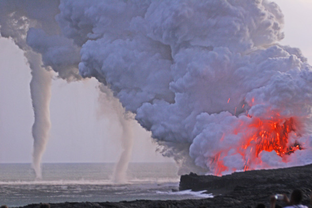
Photo is by Stephen & Donna O’Meara
Eruptions are both scary and beautiful. And it is not just the lava. It is also the atmosphere.
What are your stories of volcanic weather phenomena? Please us the comment box to share your knowledge and experience!
Albert, May 2021
And for a bit of volcanic atmosphere, I can strongly recommend the Meradalir camera.


Beautiful, and terrifying, too. Having been ‘hugged’ by a small, Summer Dust Devil, I’ve mixed feelings about them…
( Took several showers to get the last of the dust out of my ears etc, an ‘extra-rinse’ wash-cycle to de-grit my clothes… )
IIRC, ‘Martian Devils’ are remarkably numerous during some seasons, have kept several solar-powered landers and rovers going beyond expected life-time by sweeping accumulating dust off the panels…
There was a lot of lava devils above the lava river at Kilauea in 2018 too, one was caught on video but reportedly it was very common and none if them ladyed long enough to get filmed. There is also a report from Thomas Jagger in the early days of HVO of a really powerful one inside Halemaumau, enough to rip apart the surface of the lava lake. I also saw some on the 1970 lava field at Hekla on a short documentary about said eruption.
I would guess this is a very common phenomenon that is just not widely reported, my first time reading about it was the big one at Holuhraun and then again at Kilauea, both very big eruptions, but now they are showing up at a small eruption too it seems there is no special requirement.
The closest I have been to an active lava flow is a doors-off helicopter flight over Pu’u O’o, a couple of weeks before the drainage event of 2018 that started the LRZ eruption. We didn’t see any rotating air action, other than that which kept our whirly-bird aloft.
I grew up on the south coast of England in Sussex; water spouts were a thing generally in summer, staying well off coast and providing a spectacular column connecting sea to sky. They wouldn’t happen every year.
We took the offspring to Switzerland one year, taking the train up to the Top of Europe, the Jungfraujoch. We hiked to the Munch Hutte for lunch. I heartily recommend the rosti and home made soup. On the way, the winds were blowing up the northern slope of the massif, reaching the ridgeline about 100 metres above the path, and meeting the corresponding updraught from the southern side. Snow devils resulted, gently buffetting as they slowly wended their way across the path.
The bulldozer and excavator have move off camera to the far right of the lava flow. Looks like they are about to begin a second dam.
To the right below the camera (out of view) is another potential exit from the valley, so they need to block that off too.
Gutn Tog said He would get some video of the excavators today ( 05/15 ) and
post them no later than Monday ..
Here’s the video of the earthworks from Gutn Tog ..
Does someone know whether the unnamed 426BC eruption (likely in the Tropics) caused an impact on the climate and what impact, what source it could have been and if some world events are related to it?
I cannot answer your question directly, but may be able to narrow down some areas for research. 426 BC is 2376 BP, approximately the beginning of the SubAtlantic climatic period. This is the climatic period that we are now in, and the early part of it is characterised as up to 1 degree celsius cooler, and wetter, than the SubBoreal which preceeded it.
What this gradual change was caused by is a moot point, but it shows up in changing vegetation types in the pollen record, from zone VIII to IX, with more beech and hornbeam displacing lime and hazel.
In the historical record this was the time of the establishment of Rome, Jeremiah was around in the Middle East. So, the Bronze age.
Jeremiah had been dead for 150 years by this time..
Mixing my sources, or they’re wrong… It’s been too long since my last religious studies lesson 😉
Jeremiah was in the time of Babylon, which was a rather short-lived empire. (Their economy was an empire-sized pyramid scheme, really.) I wrote a bit about it in https://www.volcanocafe.org/the-hanging-gardens-of-babylon/
The Peloponnesian War (431–404 BC) is also around that time, which gave rise to the Greek Philosophy (Socrates/Plato, Aristotle…) which then of course has been of fundamental importance to the development of Western Civilization as we know it.
I think Juno Probe will pass IO soon.. are you thrilled? we will see how much new lava flow resurfacing
IO haves the largest lava lakes and active surface lava flows in the entire solar system! some compund lava flows on IO are many 100 s of kilometers long, and some lava lakes are as wide as 50 km and 80 km long… perhaps windows into the moons molten magma ocean interior. Their largest lava flow from 1999 galileo is the Amirani Lava flow 400 kilometers long. IO probaly erupt 600 km3 of lava and pyroclastic materials every year.
Have this Juno flyby been cancelled?
They talked about it before.. closeup Photos woud be Awsome .. IO s lava lakes and basaltic lava flows are immense .. compared to todays earthly standards
Pele Patera is IO s most active lava lake 60 km long and 25 km wide .. totaly churned by lava waves and huge fountains
And Loki Patera is a magma ocean .. : ) Thats have a more sturdy crust on it .. and less thermal emissions.. its 240 km wide : )
The IO flybys are in 2023 and in 2024 – you will have to wait awhile. There is a close flyby of Ganymede in June this year.
https://www.youtube.com/watch?v=rlwd_ajNo9g
Great video from Gutn Tog of the newish lava flows into the MMBB Valley of No Name, lots of lovely volcanic sounds at the moving a a front, and then looking at the characteristics of the pahoehoe flowdown the eastern side. Posted today, but recorded either yesterday or the day before.
Even our Volcanoes are into the Green Movement. However eco friendly it appears though, I would not like this at the end of my Veggie patch, I will stick with bags of vermiculite as the nearest volcanic product in my garden! At least I can control that.
It looks like dinosaur bones. Gorgeous. I wonder if the colour changes as it ages.
Views of people and lava river from Theater Hill ..
As a young child, I remember very well the Billings Montana tornado and horrific hailstorm of June 7th, 1958. The sky got very dark around 2 pm, we were in downtown Billings, shopping, and residents grew uneasy. The restaurant owner went to shut the glass door but a person from Oklahoma said “Don’t do that, the pressure change will blow out the door”. A strange white horizontal swirling roll cloud appeared overhead, then the sky got very green. You could not mistake the green. Then the hailstorm hit, millions of tons of hail dumped on BIllings, and the hail would split upon hitting the asphalt pavement and concrete sidewalk and the fragments would sting and hurt upon impinging into your legs and upper ankles. I finally had to come inside.
The store next to us had shut their door.. sure enough we heard a big crash as their window blew out.
Around 4 pm, my dad said it is time to go home (to Laurel 15 miles west) and so we jumped in his black Ford and headed for Laurel, right into the maw of a small tornado, black menacing, the funnel sharply coming down and ending right on the very highway we were going to go down. It was not a big tornado, but nevertheless you could distinctly see it trashing stuff and things flying up in the air and swirling around. My dad made an abrupt U-turn and exclaimed “We’re not going into that!” That was my first tornado.
It did extensive damage in BIllings, ripping the roof off the Mussellshell Cafe (which was on the very highway the tornado was going down) and other damage, but the hailstorm by far did much more damage than the tornado. It literally pulverized the farmer’s crops, especially sugar beets, and in the northwest part of BIllings, the hail was so fierce that it stripped the bark right off the trees on the NW facing side. Yes, stripped the bark clean off the trees.
BIllings lost much hail insurance after this storm as the insurance companies had to make too much payments and some became insolvent, so then BIllings became a spot where you could not get hail insurance anymore, because of this amazingly strong hailstorm and tornado.
So yes, tornadoes are remarkable swirling columns of wind.
https://www.ebay.com/itm/1958-Billings-Montana-Resident-Examines-Tornado-Damaged-Radio-Tower-Press-Photo-/400803482980
The radio tower was next to the cafe, I believe to the west of the cafe.
There appears to be uncertainty on the date of this tornado, it appears to be on July 2nd, 1958, not June 7th.
Thanks for the article, Albert. Fascinating! I’d go for the genuine tornado explanation here, and the environment fits. First up the fact the cloud had a small ‘foot’ about the tornado supports some weak storm rotation. The cloud was probably a full blown cumulonimbus to start with. The weather in the last couple of days has been showery and the clouds have shown good towering through the day. The final and most important ingredient would be the heat from the lava field. Enough to kick the feeble rotation in the cumulonimbus into local ground forcing. I suspect ground-up rotation joined weak forces in the cloud.
Of course, I’m no tornado expert. After all, in my storm forum my tag is: “I am the gap between storms”.
I would love to hear other opinions on this! The lava devils are common. This one got lucky to find just the right circumstances to grow. Note that it was very short lived
First dam almost ready
https://twitter.com/SHSig/status/1393548444514537477
What is going on with the cone? There have been 2 collapses between 6 pm and 7 pm with big clouds of yellow brown dust shooting up in the air. (cone was not erupting). Does anyone know?
What I would do to stop the kava from affecting surrounding Icelandic populations or infrastructure?
Not build a wall but rather dig a channel.
Dig a channel to divert a lava flow into another direction is far likely to work than stoping a flow with a wall. But the digging must be deep.
Assuming 12m3/s lava eruption, that is about 1 million m3/day or 30 million m3 per month!
If they dig a channel 20 meter deep, 50 meter wide for 10km, that would contain 20million m3 of lava, so it would basically contain all lava erupted for a month, and it would be a significant engineering effort.
Explosives could be used to create that channel.
It is likely that this channel would end up filled and with a greater height than the original terrain, hence creating a barrier. Then one could dig further sideways and force the lava to divert to just one side. In theory it should work and the cost wouldn’t be that big. Definitely smaller cost than losing a town.
Correction, I meant to say “lava” instead of “kava” and also “If they dig a channel 20 meter deep, 50 meter wide for 20km…”
In my language ‘kava’ mean coffe.
Lava is brown..black. OK make sense. 🤔😉
I’m not sure what the objective is for the berm ..
Are they trying to keep the foot path to the so called “theater hill”
open and prevent it from becoming an island ?? or something else ??
They are trying to prevent the leave cascading into Nátthagi valley, where there are power lines and optic fibre cable. Not to mention a short way to the Southern Coastal Road
I follow that logic Irpsit. but there is a matter of time and the uncertainty of what this volcano is going to do. It is so unpredictable to difficult to make decisions that could be expensive or ineffective.
Thing is that only works as long as the lava actually flows along all of it and stabilises to form an efficient path through it. It the flow stops on the way the channel is useless.
It seems too that lava is not good at following existing channels, even old lava channels. At Pu’u O’o it was uncommon for the a’a flows of the 1980s to reoccupy the channel of a previous flow any more than immediately outside the cone itself, only time I know where it was actually an important factor was in episode 17 which was also simultaneous with the eruption on Mauna Loa in 1984, and so could be that shoving the southeast flank of Mauna Loa into Kilauea during that maybe pushed out some more fluid lava, or maybe not.
In this particular case i think the dam is largely experimental, and it only works because a second exit exists, otherwise I doubt they would bother it isnt like they had issues closing access to other popular observation spots.
Imagine the lava devils from flood basalts! That would be the best.
The huge sheet lava ponds from Siberian Traps and Opening of Atlantic coud have created real massive supercells and huge rainstorms .. with so much moisture and hot convection
I agree.. as long as you wouldn’t get sucked live into the spinning vortex.
Thank you again Albert. Your posts are keeping our brains and focus well trained. I owe you a drink at the bar. Cheers!
We seem to be in a geyser type mode at present with fountains every 5 – 7 minutes. Here is the pattern on the drum plot which appears to correlate with fountaining episodes.. I could be quite wrong on this. please correct me if I am

Spectacular, and very pretty too!
The drumplots are amazingly regular! And the fountaining quite impressive at times. But the lava flow seems subdued. Perhaps it is going somewhere else – saw the wall, took the hint and went the other way. in fact there was a much stronger flow into Meradalir last night. I am rooting for the wall.
Obviously the link is not allowed. Sorry about that but if you have access to the Iceland drumplots have a look at faf_highpass_2.0
I am now waiting for some earthquake activity to see if that heralds the change again to a continuous flow type eruption.
Yes, Thank You, Albert! i love Your science lessons. Yes, i thought i saw one of those volcano whiries but couldn’t be sure as the light was dim. Several times i saw them follow the ‘theater hill’ around the eastern side and down the flank. Your information confirms my observations. Nice! One doesn’t always see what one thinks one sees. Best!mots
Just had a look now ,is there a new vent/cone, never seen it there before,the light is faint.!
My answer is no! Might be light reflection on dirty cam lens or what ever!
The light from the new surface flows in Geldingadalir can look like new vents at times, especially so when there is steam and fumes rising, as this makes it look even more like spattering. Nearly tricked me a couple of times when I see it out of the corner of my eye while working on a different monitor and going “Oh, what is that???? Oh… Yeah, Geldingadalir seen over the saddle”.
The RUV Langihryggur camera is quite zoomed out now, and shows both of the dams that have been put in place over the last few days.
Thanks ,that made sense for me Erik! Yes I use the RUV Langihryggur alot.
Thank you for explaining a devil versus a tornado, I didn’t know this. So before the exodus there was a frognado? Or a vulcfrognado? I decide to look this up. There is only one guy, much too early, Menengai in Kenya with a VEI 6, but solid 6ka BC. Doesn’t fit, sorry 😉
But there is s.th. interesting to see in the African rift: Lots of X. Underdocumented with the exception of Rwenzori by Albert. So I decide that the time of the exodus is underdocumented, there weren’t enough scientists I guess. There was Joseph and later Aaron, that’s it.
Anyway, I liked the piece explaining the differences. American films can be stupid, stupid enough to put a T-Rex and the plants of the Cretacious into the Jurassic, a fact you mentioned in your piece about Hawaii last year.
One question: Could it possibly be that those Cretacious volcanoes sitting on the ocean floor near Hawaii, and the Shatsky rise came from the same source, a triple junction under Farallon, Izanagi and Pacific, and then spread apart?
In this article:
“The tornado (let’s call it that, even though this name is disputable) happened on the tail end of a snow storm. Snow tornadoes (really, snow devils) are known, but they are very rare.”
I think that an anticyclonically rotating low-topped supercell was situated over this volcano, supercell tornadoes form at the rear end of a classic or an LP (Low Precipitation) supercell from the wall cloud right under the mesocyclone. At the end of that footage at the Youtube footage below you see a rotating wall cloud from 04:00 toward the end. Are there any (doppler) radar images of that particular snow storm, because supercells show a hook echo on radar. How were the windshear conditions (0-6 km Deep Layer Shear and Storm Relative Helicity 0-3 km) on May 13th over Iceland? For the development of supercells the DLS must be greater than 20m/s.
https://www.youtube.com/watch?v=NrWWCT5Lu9
There were faint signs of a wall cloud in the pictures/video but not enough to judge any rotation. But the whole system was very, very weak. I very much doubt it the cell would have produced anything under normal conditions.
I feel the mass input of very warm / steaming air parcels from the volcanic field may have locally increased lower rotation in the cell. With numerous small vortices seen on the ground already, I don’t think it took too much to give the cell a good kick and connect up a brief tornado, a sort of F0.2!
I doubt there’ll be doppler pictures. Perhaps Casey’s TIV needs to be over here… 🙂
‘I am the gap between storms’. (i.e. they avoid me. I’ve even seen one do a right turn over Sussex to avoid me. Damn things.)
Volcnado?
volcado. tornano does not sound right. volcatwister? or short, vc-twister?
Sheepnado!
Sussex!? Where and when!?
Last year, the year before, ad infinitum…
To get back to another older piece of yours, Albert (I hope these excursions are allowed or even appreciated) I have an idea concerning Billy Mitchell thinking it might be the whole story, not just the person:
http://www.volcanocafe.org/bagana-child-volcano/
This guy, William Lendrum Mitchell (1879-1936) got into a conflict with the Army and Navy when they decided to fund battleships instead of carriers. Billy Mitchell thought it was more important to built carriers and bombers. The battle of Midway showed that he was completely right. And then the most dangerous man for the US on the Japanese side, chief of the Pacific operation, who you mentioned, Isoroku Yamamoto, was finally shut down in the area. So I would reckon that part of the American success in the Pacific was prepared by the ideas and work of William (Billy) Lendrum Mitchell. Without him the Americans might have lost the battle of Midway and the West Pacific. It seems therefore logical to me to give a volcano his name (plus the airport of Milwaukee).
Another very interesting piece of yours among the many jewels, also by late Henrik, Hector and Carl and others.
Then I also read some by Tallis, Clive and Chad as well, and it’s all interesting and impressive to admit lack of knowledge in some points. It’s all very lively like volcanoes are. Back to Albert I gave Wrangellia III a second look and this time, when I came upon greenstone it rang a bell as I recently read about the green ophiolytes of Monviso, Piemonte.
Last year I was in La Morra in between lockdowns, wonderful wine. This is south-east of Torino, and south-west is Monviso or il Monte Viso. What’s interesting about Monviso’s green stones is the fact that once the beach of Tethys was stretching here, part of it. Monviso is basically exactly north of Nice, France, and in between is a continuous mountain chain, the heir of Tethys. Monviso is about half way between Nice and Val d’Isère, maybe of some interest for someone here although not volcanic today.
http://www.researchgate.net/publication/331975895_Geology_of_the_southern_Monviso_metaophiolite_complex_W-Alps_Italy
Free access, nice maps and figures.
https://m.youtube.com/watch?v=4uHc3SAqqL4
Webcam
Loving that soft cherry red lava fountain colour!
The Geldingadalir webcam shows an outbreak round the back of the main F5s crater, where there’s a huge crack been developing in one of the last remaining areas of drained lagoon floor. It’s not far from the little gas fissure that could, I do believe.
//s.imgur.com/min/embed.js
There’s also a good creeping outbreak behind and to the right of old Bob Twins/Nordri-Sudri/Gollum-Smeagol
And another inner main wall collapse at 15.28 pm, as the vent was fountaining, causing a tidal wave to move down-channel, lava slopping over the edge as it travelled. On the close-up mbl.is webcam.
And I come back from my Sunday Roast Lamb dinner, to find a snaggle-toothed crater… Another major wall collapse at 17.46.
I do wish RUV would invest in some better webcam technology. I’ve seen better pictures from my old Chad Valley projector back in the 1960s.
 for those that wonder…
It’s YT that degrades the video quality of the cameras on RUV2 direct that was fine, but the programme just switched at 6pm from the volcano to something else.
Ruv2 direct: https://www.ruv.is/sjonvarp/beint/ruv2
i dinna open it….. was it ski Finland?? 😉
Ah hah – that proves they are using Chad Valley technology!
MBL seem to have way better quality.
Clive ..
Click the settings icon ( looks like a cog ) bottom right ..
You can set video “quality” to HD1080 ..
It looks like (to use Jesper’s analogies) the “Helm’s Deep” wall for the defence of Nátthagi is now complete?
It will be interesting to see how it fares against the hordes of lava…
Slightly round the wrong way, as they are trying to keep the Orcses in!?
In any case, I want to see the Glittering Caves!
How are the new Man Made Dams holding out? They could ask the Dutch for some assistance if they want!
They only know about water 😉
If the dam gets a hole in it, there’s no point sticking a finger in it.
The lava had a few metres to go before it reached the earthworks:
https://imgur.com/zV2VCwU
Image from http://brunnur.vedur.is/myndir/listi/webcam_langihryggurNV.html#. at 21:30
Seen in GutnTog’s video (https://www.youtube.com/watch?v=aSkAw6cg8vQ 3:53) and the livestream from fagradallsfjall today, it seems like the lava decided to sneek up on the wall through the lower Geldingadalir “exit” right above the wall. Hoping this happens though, cheering for the lava!!
Thanks Luis.
(For some reason I can’t use the like button on this page. Don’t seem to have the required privileges.)
Here is another video about the “wall” from that same guy, also from today.
Hildur try clicking then clicking like again .it doesn’t work for me on first click but on second click it says “Liked by you”. Thank you for the video clip too. I like it!
I get a “log into your account” window, but it seems it’s a different account from the one I originally created, doesn’t accept my email.
I had the same problem. After some trial and error, I discovered that I needed to sign in with my original (from 10 or more years ago) email account from the time when I was using an old ISP.
I really like how Gutn Tog combines both the telling of the physical geography of the eruption, and the human response from the authorities and the ordinary people, both locals and tourists. One third of visitors are tourists! He combines the curiosity of a child about the most intriguing features from an amateur point of view, asking very pertinent questions for the specialists to ponder and come up with answers. He really makes me feel as if I were there with him; I can almost feel the heat on my skin.
His videos are and will be an amazing resource for researchers of the future.
i appreciate his coverage but i have no way to tell him…. Please tell him if You can, Thanks!
They banked up some earth against the lava flow itself first, to buttress it and provide a safe area for the workers building the actual barrier. So, it’s hadly surprising that some of the butressing has been breached.
But as the lava has temporarily stopped spreading at the southern end of the MMBB, they have a little breathing space before the actual testing time. Right now it is a stalemate. I presume that they’re doing the same thing at the eastern low point as well, although I haven’t seen any footage of that side yet.
Hadrian and his Roman soldiers would be impressed at that one…..
Seriously I do hope it either slows the creep or diverts it. The lava wall looks very menacing. Would you take your children for a stroll along it’s edge? I certainly wouldn’t it’s far to easy for a large clinker to roll down or for a child to pick up a hot rock (Shuddering at the thought)
Hats off to the Icelanders for such a huge and rapid effort.
Earlier today
Is it me or is the lava getting more gassy?
I see there is a small earthquake swarm at the end of the Reykjanes Peninsula in the last few hours.
The drumplot appears to show some seismic fracturing, or ‘poppers’.
My guess would be the very beginnings of an intrusion. It may settle and go quiet for a while (possibly years).
But it would appear the Reykjanes awakening is truly underway.
On that thought there have been many intrusions near here over the past decade, I expect it will erupt in time. I do wonder what effect having an unexpected deep mantle eruption in the middle of the peninsula will have on the whole cycle, the eruption is its own thing but within the fissure swarm of Krysuvik, and has ruptured the section of the fault going through it so I expect more activity here. There was the intrusion at Svartsengi last year too, and the current swarm at the end of the peninsula.
Seems to me as though this cycle will not at all behave as predictably as the last one, we could get an eruption anywhere really, it could be a lot more rapid succession than lasting 300 years too, probably will be rare to have a decade without activity the rest of this century. I think it is going to be the main center of activity unless there is another major eruption from Vatnajokull, but no signs of that for sure as things stand, its too soon after Holuhraun to expect another major rift.
It strikes me that the main reason why the last cycle was so predictable is that it has already happened. Witnessing a new one unfold is always likely to bring surprises 🙂
That is true, but I suspect even back then there was maybe a very rough idea of a pattern, it would be noticeable for eruptions to trent generally to the west, especially later in the sequence with the knowledge of the older eruptions being closer to Reykjavik than those in the 1200s.
Today the eruption that has begun the cycle is right inbetween the two systems that tend to erupt near the end, the Krysuvik eruptions were in the 1150s and another small eruption in 1188, and then eruptions began at Svartsengi only 20 years later in 1210 or thereabouts, maybe even before this. I do think there is a small possibility they are fed out of a common deep source in the mantle, the same deep source feeding the eruption today. Whether the ongoing eruption eventually drains the source of magma starving its neighbors or actually enhances the magma generation leading to greater activity at all three than was the case last time we will have to wait and see. I think we will though see eruptions at these places before eruptions at Brennisteinsfjoll, which might sleep for a few decades or centuries longer, and in quite a contrast to previous cycles.
The previous Reykjanes cycle came after (or just the same time) as Eldgja. This was a massive rifting event. I wonder whether it was massive enough to affect Reykjanes, in spite of the large distance.
This might have been a relative coincidence though, there was not an Eldgja sized eruption 2000 years ago, and there was not a new eruptive cycle after Laki either, apart from a single eruption at one of the offshore segments that seems not to obey the Reykjanes cycle regardless. I think the Reykjanes cycles are related more to the plate motion, if the fault is entirely transform then no magma can escape, but if it spreads as well then it becomes eruptive.
https://imgur.com/a/m4p9M6n
Dust devil at 2.30am
The perched lava pond is visible from the Slagi Natthali Valley webcam, glowing away until 5.53 am, the latest that I’ve seen. If that lets go towards the south…
I wonder if the authorities are planning on trying to ‘encourage’ the flow itself to go north?
A perched pond can be a sign that all is not well with the lava flow.. It has grown a lot higher in the last day which is why it so well visible from natthagi. Even in the day you can see the straight line of the pond. A break-out would send a lot of lava in a random direction. A well-aimed explosive might now send it north?
Lava flash flood 🙂
In order to make much of an impact, explosives would need to be embedded within the mass, though. Detonating on the surface is not likely to do much unless the crust holding back the molten laval is exceedingly thin.
I believe the US Air Force tried to drop bombs on a lava flow in Hawaii in 1935 in an attempt to divert it.
Short of getting a charge embedded into the lava flow itself, which feels like a rather unsafe thing to do, the best option might be to place a charge into the ground next to the flow and try to have the shockwave travelling through the ground break open the side of the flow. It doesn’t sound like it is much safer, though.
Is there a reliable and safe(ish?) way explosives could be used, short of deploying bunker busters?
Not just 1935 but 1942 as well, the bombs were recently rediscovered embeded in lava.
Really I dont think that anyone intends the lava to be stopped entirely, its to slow the inevitable. The plan is probably to get it to favor the north outlet but its just nature for these sorts of lava flows to branch out. If anything damming the flow is going to make it more destructive when it breaches, we will soon see a fast flow racing into Natthagi I expect.
Sorry for coming up again with another topic. I can’t add a.th. to Reykjanes. You had a discussion, Albert, with somebody under WR III about a possible plume for WR’s LIP. That can’t be Hawai’i. You place WR in a semi-tropical environment, and the time is 232 Ma. 50 Ma WR takes off from the West coast. Therefore it can only be Galapagos or some other existing or extinct plume in that area. The distance from MAR to east coast seems to be similar to the east-west distance Galapagos-WR.
Maybe you disagree, or I think too simple. But the time and the description of semi-tropical would better match with s.th. further south (-east of course), imho. Ingenious trilogy, btw, about WR. Very interesting also the neighbour across the street, East Siberia, great piece as well. Thanks for all four.
After consulting Blakey’s maps with latitudes I changed my mind. Maybe hotspots are overrated. The Jemez lineament has been thought to be caused by the Raton hotspot, but times don’t add up. The same was described by Carl, I think, (or Hector) from Mount Cameroon and the island chain in front. Blakey has WR at about 25° North 245 Ma.
The important question is how long do the hot spots survive? The ones we know are 30 (Yellowstone, Afar) to 100 (Hawai’i) years old. Reunion is 60-90 million years. On oceanic plates the evidence disappears within a few hundred million years because of subduction. On land they should survive much longer. The fact that we see nothing older than 100 million years suggest that they don’t live much longer than that. It seems unlikely that the Wrangellion hot sot still exists, and it seems likely that anything else it left behind during its life has been subducted.
There has been some work recently implying the Yellowstone hotspot was responsible for the Siletzia oceanic LIP before being overridden by the North American plate. (Camp 2021), which would extend the lifetime to at least 56Ma
I am actually replying to Albert belowm but there was no option on his comment.
To Cabrageo: There’s a strong point for plate tectonics though as Siletzia was accreted at the time of the initiation of the bend of the Emperor Seamount Chain from West to North, so a change in direction of plate movement.
I consider the West Coast of both Americas intricate and complicated. It reminds me of a Gothic Cathedral standing on a Romanesque Church standing on an early crypt standing on a Roman villa, but not so orderly.
So I agree with some authors like Hector, Carl or Tallis that it is an area for some surprize including calderas. This might go for around 7.000 miles from Cascadia to south of Santiago including Galapagos.
Siletzia was accreted 51 to 49 Ma. The Emperor Seamount chain bend was 47 Ma. Two separate events.
Several vortices are caught on this camera, covering a much wider field of view over the sea.
http://brunnur.vedur.is/myndir/webcam/2021/05/17/webcam_meradalahnukurSSV.html#
11am, today. those things are showing up everywhere now!
https://www.volcanocafe.org/wp-content/uploads/2021/05/webcam_langihryggurNV_20210517_1100.jpeg
There was also a nice one at 10:30am, seen on two cameras. It is hard to be certain but it seems both formed over the same lava field within the original geldingadalir, perhaps where the lava is flowing hottest.
Twister on Reykjanes webcam:
https://www.livefromiceland.is/webcams/reykjanes/
Image: https://imgur.com/NsZr76n
I don’t remember seeing this posted here, the good people over a the Flocam are following Ragnar’s pulsing and documenting it. There’s a few nice graphs of analysis. Any of our expert dragons care to comment?
https://docs.google.com/spreadsheets/d/1Rt5Tx8LNwrNTVqHZYG5yVZVoQlf-xJdCq9htJfEOymo/edit#gid=0
I’m no dragon (more like a dormouse out of hibernation). But my take on those graphs is the intrusion is waning and our vent will, before too long, cease. The eruption will be over.
But of course, I am no expert!
Barring a ‘phase change’, that is. Who knows what the intrusion is doing deep down? I suppose changes in the drumplots might warn of that.
https://imgur.com/a/cC2zBFO
Bigger overflow just happening.
It would be good if RUV zoomed out more on the Langihryggur cam so we can watch the lava spreading from the overflow and maybe approaching the dams.
This one stalled out, like the rest. There is another higher up the channel, looping around the back of The original fissure vent again, heading southwest.
The main crater erupting at Fagradalsfjall. Is it the one that started the eruption or was this the second fissure that opened to the north?
A shield volcano is forming, exactly as I expected.
The main crater that is erupting is Fissure 5, it has made good effort to cover up the original twin vent of Fissure 1
There’s a bit of steam coming out of the old vent 1. (4pm Island Time). Not sure if it is ejecta, or actual venting from below.
I should add that it is on the top of the cinder wall, not from the original vent. Possible steam coming up through a crack?
This is from nattaghi-cam. One example frame cut-out, with the positions of the 4 obvious lava devils of this morning. They all formed in very similar locations.
Spotted this one on Meradalir SV cam, it looks quite large. Timestamp is 14:00
Nice catch. It is also on the RUV camera. It formed during the cone fountaining and over two minutes moved left our of the frame while improving its shape.
There’s the strong updraft to get them started, I suppose.
Thank you for the complete answer to WR. Here’s some awful devil:
bbc.com/news/uk-57139989
Predicted Path for Cyclone Tauktae, Indian Ocean, India
This is from 2002, but quite good. About the Kerguelen hotspot:
academic.oup.com/petrology/article/43/7/1121/1465694
BBC again:
http://www.bbc.com/news/uk-57139989
one try with www:
http://www.academic.oup.com/petrology/article/43/7/1121/1465694
Nice article Albert, on the differences between true tornadoes and simple rotating updrafts/whirls such dust devils, firenadoes, etc.). Here’s a couple of thoughts/yammerin’s:
A rotating updraft (such as from a fire whirl, etc.) or heat from a lava field at Geldingafalir) can evolve into a true tornado under just-right atmospheric and orographic conditions, since I witnessed one first hand (albeit from a distance) in Redding (as previously mentioned in your last post).
A true tornado starts aloft, originally as a horizontal circulation which then rotates into a vertical column as it descends towards the ground. So in a nutshell, a tornado evolves up-down while a surface whirl forms down-up. A good clue is where the widest thickness is. If the whirl has a thicker top, then it’s most likely atmospheric driven…while a uniform width of the whirl indicates it’s surface driven. Weather chasing 101.
I suspect that there is/has been many, many more of these “whirls” that we never saw. The only reason we visibly saw the one you wrote about is due to water vapor/So2? condensation surrounding the low-pressure core, most likely due to the obviously high ambient dew points. Under these near-saturation conditions, it would only take a miniscule change in strength of the whirl to shift the saturation point enough to make the condensation come and go in a matter of seconds.
So, what happens when a whirl develops under ideal (i.e. moist and inherently unstable) atmospheric conditions?
In the case of the Redding inferno (perhaps the most studied related event in history), the location of the CARR fire was in a well-known convergence zone, as cool air aloft from the WNW riding over the Trinity Alps get’s funnelled into the northern Sacramento Valley just west of Redding, where it collides with the hot Valley surface winds coming from the SSE. At the time of the CARR fire’s start, there was a shallow (but growing) line of Cu directly over the area, indicating some instability was in place with a quasi-“inverted V” signature in the soundings up to ~ 5,000′.
As the fire grew nearly exponentially, a massive PyroCb (indicating free-convection) was generated, which is rare but hardly unheard of. But what made this particular PCb/supercell so powerful, was due to a pulse of moisture plus orographically-induced shear, which made the atmosphere ripe as could be for rotating updrafts. What appears to have happened, is a fire whirl entered into an updraft under the thunderstorm that the fire had triggered. The updraft then “pulled” the fire whirl aloft where it “phased” with the updraft, thus coupling the fire directly into the thunderstorm. Then, due to the inherent angular momentum of the fire whirl plus the continuing effects/shear of the convergence, the combination initiated a powerful F3-F4 tornado estimated at nearly 1/4 mile wide. So while this “firenado” first started as a “simple” fire whirl, it essentially evolved into a true tornado.
It should be noted, (but not widely reported), is downwind of the massive tornadic PCb that was created, hail did a fair amount of damage to the north of Redding. Coupled with all the smoke and ash along with nickel-sized hail (~2cm) falling, the area looked like nearby Mt. Shasta had erupted….except the “lapili” was white instead of black.