
A fun question: which are the southernmost, most equatorial and northernmost volcanoes in the world? We need to add two provisos here, otherwise this question is impossible to answer: the volcano should be on land (sub-aerial, not sub-marine), and it should not be extinct but be known to have erupted.
I’ll give you a few minutes to think about. Two of them should present no problem. Volcanoes are thick like flies near the equator, but are very sparse close to the poles.

Ready? Number 1 is Erebus (77 degrees South) – no problem there. Number 2 is harder – your answer in the comments, please. And number 3 is that rare mountain: a volcano with a Dutch name and even taller than the (mythical) Zuidwal volcano. (We are happy to see that the VC review of this volcano is among the few sites that have survived google’s culling.) It is the infamous Beerenberg on Jan Mayen island (72 degrees North). The infamosity is because its eruptions are nearly impossible to observe. Most of the time the island is covered in the North Atlantic cloud and fog, and if an eruption were to happen during clear weather, very few people are anywhere near close enough to see it.
(One may wonder whether volcanoes try to avoid the polar regions. There are some 1350 active volcanoes on Earth, which is an average of 1 volcano per 350,000 square kilometer. About 10% of the Earth’s surface is closer than 15 degrees to the poles. So one might expect 10% of its volcanoes there – rather more than just 2! The reason for the lack of volcanoes is that the major active rifts and subduction zone currently avoid the polar regions, that the Arctic is mainly sea and submarine volcanoes tend not to be on the list of active volcanoes, and finally that the Antarctic ice sheet (and probably Greenland’s as well) hides and suppresses volcanic activity.)
Discovery
It is likely that Jan Mayen was the original Svalbard, as named by the Vikings on Iceland. But the island had little or no use to them, was never settled and became forgotten again. Nowadays, the name has been transfered to Spitzbergen, much further north but regrettably non-volcanic.
The island was (re-?)discovered in 1614 and 1615, by several ships. Of course, just finding the island was not enough. The discovery had to be reported to the ship’s owners, and then by the owners to the official channels. The first one to find it reported it the funders, but they kept its secret for commercial reasons. The second and third ship arrived (together) while the first ship was still there. All three ships were Dutch. A year later, an English ship followed. By now the island had been given four separate names, including the old Viking one. The French added a 5th one 20 years later. None of these names were to stick.
All of the ships made maps, of varying accuracy, and these indicated names for separate features. One of those features (a small promontory) had been named ‘May’ after the captain of one of the ships. A few years later, this map was redrawn to become part of the famous Bleau atlas (the most famous atlas you have never heard of). On this map, the name ‘Ioanne Mayen’ was now assigned to the entire island, overruling all other names. (the ‘en’ ending means the same as the ‘ ’s’ in English.) Hence the name ‘Jan Mayen island’, immortalizing Captain Jan Jacobszoon May van Schellinkhout of the ship ‘Golden Cat’. The island was used as a whaling base for the next 20 years, but the whales soon ran out (or swam off) and Jan Mayen Island became abandoned.

Since 1930 the island has been Norwegian, being donated to the country by the League of Nations. Norway has had to repel attempts of hostile take-overs by Germany in 1940 and by Iceland(!) in 1979. The latter dispute was initially about fishing rights. Owning an island gives a nation a 200-nautical-mile economic zone around it. This zone overlapped between Jan Mayen and Iceland. When this area became economically important (i.e. exploitable fish resources), this led to a territorial dispute. Initially Iceland denied that Jan Mayen was an island! It also claimed that Jan Mayen was part of the continental shelf of Iceland. Neither claim seems particularly strong, in hindsight. But the dispute led to a formal, internationally recognized (though not by all countries) definition of an island:
“An island is a naturally formed area of land, surrounded by water, which is above water at high tide. [..] The territorial sea, the contiguous zone , the exclusive economic zone and the continental shelf of an island are determined in accordance with the provisions applicable to other land territory. Rocks which cannot sustain human habitation or economic life of their own shall have no exclusive economic zone or continental shelf.”
Thus, Jan Mayen became an island! The dispute was resolved peacefully (Iceland got a little more out of it than Norway) and the exploitation of the disputed area was shared. The problem has now become relevant in other places of the world, especially the South China Sea where there seems to be less willingness to resolve the claims in the Scandinavian way.
And so Norway became in possession of some fish, a sliver of continental shelf originally from Greenland, possibly oil or gas resources on this shelf, and an active volcano.
The fish may have reason to be concerned. Norway may nowadays be known as a country sympathetic to ‘green’ issues, it has a distinctly ‘non-green’ history. Norwegian hunters arrived on Jan Mayen in 1906 and quickly left the island devoid of life. As elsewhere in the arctic, musk ox and polar foxes were present, but here they were hunted to extinction. There is also little flora (there is an endemic species of dandelion), and even the omni-present polar bears have largely disappeared, although in their case because of global warming which has raised average temperatures here to above freezing – even in winter drift ice now rarely reaches Jan Mayen. To see the arctic in all its life, go elsewhere: Greenland or even Spitsbergen have fared much better.
Jan Mayen Island was declared a nature reserve in 2010; severe restrictions on tourists have made visits nearly impossible. It is not clear what the reserve is intended to protect – the statement was made that it ‘is a poorly understood ecosystem that needs to be protected from risks unknown’. Perhaps ecosystem means the local military base! Sea birds still breed here in splendid isolation and protection, but other bird species are absent because of the lack of vegetation. There is no tundra here – just rock, in places covered by moss and lichen and the occasional lost plant.
There an interesting aside to the story how Jan Mayen became an island. The Kolbeinsey Ridge is named after a valley in Iceland, or rather, to a settler who lived there: Kolbeinn Sigmundarson. In an angry mood (a common problem among the Vikings of a millennium ago, apparently), he managed to crash his ship into a rock in the North Atlantic, and lost his ship, his crew and his life. After this the rock acquired his name: it is a small island north of Grimsey (and located on the Kolbeinsey ridge). In the middle ages, Kolbeinsey was a 700 meter island . Over time it eroded and after 2000 it remained as two rocklets, now only visible at low tide. Iceland used this island (at that time still above water) to extend its 200 nautical mile fishing zone and even built a helicopter landing base to strengthen the claim. (The helipad was lost to the sea 20 years ago.) The redefinition of ‘island’ meant that Kolbeinsey no longer qualified and Iceland had to give up some of its fishing claim. You win some, you lose some. But losing an island must hurt.
Jan Mayen island

Jan Mayen is 700,000 years old, is 54 km long and has an area of 380 square km. The climate is cold maritime, and the North Atlantic weather is fog, wind and drizzle. The island consists of three parts. The larger northern part is dominated by the volcano called Beerenberg, 25 km wide and over 2200 meters tall. Beerenberg may be the tallest mountain in the world with a Dutch name! Towards the southwest is a narrow peninsula, 6 km wide and 600 meter high, connected to the northern part by a 2km-wide low isthmus. The three parts are simply called Nord-Jan, Midt-Jan and Sor-Jan. Sor-Jan is in effect a volcanic ridge, up to 700 meter high. Midt-Jan is a lower, narrow ridge which lacks volcanics. It contains a large lagoon on the south side which dries up in summer. Nord-Jan is in effect a synonym for Beerenberg.
Beerenberg is that rare beast, a stratovolcano built from basaltic lavas. The mountain consists of a broad base, rising at an angle 30 degrees to 1500 meters altitude, with a much steeper cone (45 degree) on top forming the summit. The reported height of 2277m seems to come from quite an old measurement. There is no recent confirmation of this value and the only topographic summit map I have found doesn’t reach quite so high. There is a volcanic ridge extending to the northeast, terminating in cliffs with a low platform near sea level (Nordkapp) which is from more recent volcanics.
Jan Mayen Island can be seen as a 50-km long volcanic fissure (or two offset fissures, one for Sor-Jan and one for Nord-Jan), with a single volcano (Beerenberg) superposed. The inhabited (if not fully habitable) part of the island is the Sor-Jan peninsula. The main town is called, somewhat optimistically, Olonkin City. It has a year-round population of 15 men and 3 women (that was in 2019). People are allowed to live on the island for a maximum of one year.

© Rolf Stange – Jan Mayen. Reproduced from https://www.jan-mayen.com/jan-mayen-information.html by permission. Not for redistribution.
Black circles: 17th century whaling stations. White circles: 17th century whaling stations (assumed). Squares: Stations (1. Eldste Metten = weather station 1921-1940. 2. Jøssingdalen (weather station 1941-46 and garrison), 3. Atlantic City (US Coastguard station, 1943-46, weather station 1946-49) 4. Gamle Metten (weather station 1946-62), 5. Olonkinbyen (today’s Norwegian station, active since 1958), 6. Helenesanden (weather department of the station since 1962).
Breen = glacier, bukta = bay, Kapp = cape, Nylandet = New Land, sletta = plain, Vika = small bay.

Source Pall Imsland, 1978 Nordic Volcanological Institute 78, 13 https://nordvulk.hi.is/sites/nordvulk.hi.is/files/NVI_Reports_pdf/nvi_report_7813_low_text.pdf
The microcontinent
Jan Mayen is the tip of an iceberg. Look under water and a complex region surfaces. To the south, a thin ridge extends 300 km towards Iceland, eventually ending in the Jan Mayen trough. This sliver is called the Jan Mayen Ridge; it has a flat top of 10-30 km wide. On the north side runs a fault zone, the West Jan Mayen Fault Zone, which frequently has minor earthquakes, such as in the last few weeks, or even major ones such as the magnitude 6.4 in March this year. Towards the northeast runs one of the Atlantic mid-oceanic rifts, the Mohn’s Ridge. It terminates at the fault zone, jumps west and continues there as the Kolbeinsey Ridge which connects to the north coast of Iceland. Southwest of Jan Mayen runs another fault zone, called (you guessed it) the East Jan Mayen Fault Zone. Far east it connects to yet another Atlantic mid-oceanic rift (the Atlantic is full of them), named the Aegir Ridge. This one is inactive.

Clearly, interesting things have happened here.
Some 50 million years ago, this was the last connection between the American and Eurasian continents. Further south, the two had already separated, and now the division was reaching the north. The split happened along the Aegir Ridge: here was where Norway and Greenland separated. It was accompanied by a brief flood basalt eruption on the Greenland side. The future Jan Mayen Ridge remained part of Greenland. Eventually, the Aegir Ridge had run its course: spreading slowed dramatically 43 million years ago.
Now a new spreading centre formed along the Greenland coast. This became the Kolbeinsey Ridge, and 25 million years ago it split off a sliver from Greenland. This happened with a much lesser fanfare of volcanics. The split fragment consisted of continental crust with a covering of the older flood basalt lavas, but it had become stretched and thinned during the rifting. This thinning caused it to sink below the waves. The spreading was slow, but sufficient to move the sunken sliver away from Greenland: it became a lost microcontinent, the Jan Mayen Ridge. It lies currently 500-1000 meter below sea level. Oil and gas reservoirs are considered likely, due to the close geological relation to the Norwegian continental shelf with its (now heavily depleted) oil deposits. But although some licenses have been issued, no discoveries have yet been reported.
The Mohn’s Ridge became a bit an orphan in all this. It originally was the northern end of the Aegir Ridge. When the Kolbeinsey Ridge developed, the new oceanic crust moved the Aegir Ridge eastward and left the Mohns Ridge stranded. It remains a spreading centre, but a very slow one. The separation between the two spreading regime became the West Jan Mayen Fault Zone: it accommodates the different movements, and is a transform fault which delineates one of the borders between the North American and Eurasian plates.
Jan Mayen Island lies in a fascinating region! But it also exists in splendid isolation: everything else is deep under water. And of course, all eyes are drawn (on a rare clear day) to the beauiful stratovolcano which dominates it.
Beerenberg
Whilst all of Jan Mayen has a volcanic origin, the main volcano is the impressive Beerenberg, the 5th highest volcano in Europe. As already mentioned, it is also the northernmost active volcano in the world (discounting any beneath sea level). The central crater (called Sentralkrateret – more a description than a name) is 1 km wide, is covered in snow, and is the source of the Weyprecht glacier which flows through a breach in the crater wall. It is one of a number of impressive glaciers, several of which until recently reached the sea. Now, only Weyprecht still does.
Until 1970, Beerenberg was not considered an active volcano, despite old reports of minor eruptions. The oldest such report was from 17 May 1732, when a Dutch sailor on an anchored ship saw a small eruption with flames and black ashes. It came from the south-eastern slope of Beerenberg and lasted for about 28 hrs. The same area had another small eruption on 29 April 1818, this time observed by the British polar explorer (and whaler) William Scoresby, Jr. He saw a smoke column rising to 1 km. Neither event produced lava. It is worth noting that similar events in the winter could not have been seen, and it is quite likely there have been more, but unobserved, events.
Beerenberg received little attention after this, not being designated as an actve volcano. But on 18 September 1970, that changed. It started with a magnitude 5 at the north side of the island. This was followed, probably immediately, by a large eruption. The eruption was not seen by the local observers at the weather station, who were affected (as usual) by snow and fog. In fact, they did send out a patrol (by car) to see the effects of the earthquake, but the patrol did not see anything, in part because they went to the northwest corner (where there was a road) while the eruption was in the inaccessible northeast. The eruption cloud was subsequently found on satellite images. In southern England, the following days showed volcanic colours in the twilight skies: the ash and dust had spread across the Atlantic.
On 19 September, there was another felt earthquake on the island. The pilots of a plane which had taken off from Jan Mayen on the way to Norway saw the mushroom-shaped eruption cloud – although they did not recognize it as such. Early the next morning (3 am, 20 September) a Japanese plane saw a cloud rising to 10 km, finally recognized it for what it was, and reported the eruption. They were shortly followed by similar reports from other aircraft. There may have been further explosions between 18 and 21 September: it is hard to tell with such an obscure(d) volcano! The weather station, 30 km away, was quickly (and briefly) evacuated, although in hindsight this had not been necessary.

Source: Birkenmajer 1972, https://geojournals.pgi.gov.pl/agp/article/view/9850/8385. The symbols in the top right show the eruption sites of 1970.
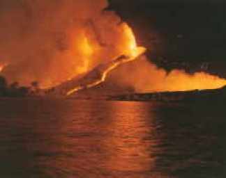
On 21 September, investigators arrived and finally found the eruption in progress. The eruption occurred in four locations along the northeast coast, over a distance of 5 km. Lava fountains were 200 meters high and the lava flowed in four streams in to the sea. The lava extended the shoreline by 1 km, and the depth of the sea reduced by 100 meter. It seems, however, that this was not just due to the lava. There may have been a collapse along the coast, or perhaps a rotation of the coastal block with the on-land part sinking and the part lower down rising. The lava flows lasted until mid-October – it may have continued until December but the weather was too poor (or rather too normal) to investigate.
There was a final observation of smoke on March 16 and 23, 1971, in both cases after an earthquake. On the second date, there was also some fumarole activity on the southern side of Beerenberg. With that, the eruption had ended. The lava volume is estimated at 0.5 km3, but this seems quite uncertain.
A new earthquake swarm occurred in January 1973, with more than 300 detected events, which resulted in an explosion crater next one of the 1970 eruption sites which was found in the following summer. Widespread fumarole activity was seen in the area that summer. However, whether this constitutes an eruption or an after-event is not so clear. Many sites list an 1973 eruption, and one AI even tried to tell me it was enormous (being confused with 1970 – it is all the same to an AI), but this is all it was. It seems better to describe it as a late hick-up.
Beerenberg was by now thought to erupt on average around once per century. Thus, 1985 brought a surprise when on Sunday 6 January an earthquake swarm with several high M4 events heralded a new eruption. It happened at extreme northeast corner of the island. The weather was clear enough that a red sky could be seen from the settlement, 30 km away. Commercial planes flying overheard early the next morning reported seeing lava flows. A plane was arranged to fly from Reykjavik to observe the eruption. It arrived in the afternoon, just after the eruption had ended. A photo from this excursion is shown below. The observers saw three new craters, one of which emitted the ash plume, while a white plume at the coast showed where lava had reached the sea. But the craters no longer had lava flowing out of them, although there was still lava visible inside the craters. The total lava volume of the eruption was probably no more than 0.01 km3.

Source: Pall Imsland , Journal of Volcanology and Geothermal Research, 28 (1986) 45–53 (sorry, paywalled – reading is strictly prohibited.)
Beerenberg volcano is in fact fairly active, although not at the level of some of the Icelandic volcanoes. Ancient eruptions are recorded in the Greenland ice. Fumarole activity in the crater is common, but the central crater is probably currently blocked by a cold plug, and all recorded eruptions have been from fissures in the flanks. But there have been holocene eruptions from the summit and they could occur again. Sor-Jan has not been active in the holocene and is probably a bit like the Reykjanes peninsula – active when it wants to, quiet when it doesn’t, and without any central volcano.
The 1970 eruption (T. Siggerud)
De-spotify Jan Mayen
Why is Jan Mayen’s Island here? It is sitting at the end of a spreading centre but those normally remain submerged. Iceland is a counter example where a spreading ridge rose above sea level, but that is attributed to a hot spot. It has therefore been suggested that Jan Mayen too has a hot spot underneath it. This hotspot even has its own wikipedia page which neatly summarizes the evidence for it – it is a very brief page! A mantle plume has been mentioned, similarly with limited evidence. There is an indication for one underneath Iceland and underneath the Kolbeinsey ridge, but not underneath Jan Mayen Island. The sea floor bulge that should accompany a mantle plume (present around Iceland) is absent from Jan Mayen. That leaves the explanation for this isolated volcanic spot up in the air!
Jan Mayen’s location is part of the mystery. It lies at the place where the Jan Mayen Ridge connects to the Mohn’s Ridge. One is a sliver of Greenland’s continental shelf, the other is an oceanic spreading centre. Which one does Jan Mayen belong to?
Drilling has shown that the Jan Mayen Ridge consists of sediments (not unexpectedly) without lava – there are some tephra layers but these may come from Jan Mayen. In contrast, Jan Mayen Island is mainly volcanic. Any sedimentary basement lies deeply buried. The volcanic nature shows that Jan Mayen Island is part of the Mohn’s Ridge, more than it belongs to the Jan Mayen Ridge. This relation is strengthened by the fact that its volcanic activity is stronger in the north, closer to the Mohn’s Ridge. The fissures show the same relation, as the lines of the fissures are along the same angle as those of the Mohn’s Ridge.
But that begs the question why there is a major volcano on the Mohn’s Ridge above sea level, when the rest of this ultra-slow ridge has little volcanic activity. A finger can be pointed at the Fault Zone which terminates the Mohn’s Ridge, and which may allow magma to come up more easily. Another finger may point at the continental crust of the Jan Mayen Ridge which ends here as well but from the other side. This continental block may channel magma around it towards Jan Mayen Island. The lava production of Jan Mayen Island is about three times higher than a mid-oceanic ridge of the same length would do. Channeling of magma produced over 100-200 km length would explain Jan Mayen Island and its Beerenberg volcano.
Beerenberg may be the best protected volcano in the world. It also remains remarkably unknown and understudied. Perhaps these two are not entirely unrelated: it may be difficult to study a volcano you are not allowed to visit. We can be reasonably confident that the next eruption will come as a surprise.
Albert, October 2025


WTNT63 KNHC 281259
TCUAT3
Hurricane Melissa Tropical Cyclone Update
NWS National Hurricane Center Miami FL AL132025
900 AM EDT Tue Oct 28 2025
…AIR FORCE RESERVE HURRICANE HUNTERS FIND MELISSA STRONGER AS THE
NORTHERN EYEWALL IS APPROACHING THE SOUTHERN COAST OF JAMAICA…
…900 AM EDT POSITION UPDATE…
The eye of Melissa is nearing the southern coast of Jamaica and is
expected to make landfall within the next few hours. This is an
extremely dangerous and a life-threatening situation. Take action
now to protect your life! Residents in the Jamaica should not leave
their shelter as winds will rapidly increase within the eyewall of
Melissa. Remain in place through the passage of these life-
threatening conditions.
An Air Force Reserve Hurricane Hunter aircraft has found that
Melissa is strengthening with maximum sustained winds of 180 mph
(290 km/h). Estimated minimum central pressure based on aircraft
data has fallen to 896 mb (26.47 inches).
Another position update will be provided at 1000 AM EDT (1400 UTC).
SUMMARY OF 900 AM EDT…1300 UTC…INFORMATION
———————————————-
LOCATION…17.6N 78.1W
ABOUT 50 MI…80 KM SSE OF NEGRIL JAMAICA
ABOUT 260 MI…420 KM SW OF GUANTANAMO CUBA
MAXIMUM SUSTAINED WINDS…180 MPH…290 KM/H
PRESENT MOVEMENT…NNE OR 20 DEGREES AT 7 MPH…11 KM/H
MINIMUM CENTRAL PRESSURE…896 MB…26.47 INCHES
$$
Forecaster Kelly
896 MB!!!
Dropsonde just found 893 mb
Live stream directly in the path of Melissa
ZCZC MIATCUAT3 ALL
TTAA00 KNHC DDHHMM
Hurricane Melissa Tropical Cyclone Update
NWS National Hurricane Center Miami FL AL132025
1000 AM EDT Tue Oct 28 2025
…CATASTROPHIC WINDS MOVING ONSHORE SOUTHERN JAMAICA…
…LAST CHANCE TO PROTECT YOUR LIFE…
…1000 AM EDT POSITION UPDATE…
THIS IS AN EXTREMELY DANGEROUS AND LIFE-THREATENING SITUATION! TAKE
COVER NOW! Failure to adequately shelter may result in serious
injury, and loss of life. Residents in Jamaica that experience the
eye should not leave their shelter as winds will rapidly increase
within the backside of the eyewall of Melissa.
To protect yourself from wind, the best thing you can do is put as
many walls as possible between you and the outside. An interior room
without windows, ideally one where you can also avoid falling trees,
is the safest place you can be in a building. You can cover yourself
with a mattress and wear a helmet for added protection.
NOAA Hurricane Hunter Aircraft find that Melissa continues to
strengthen with maximum sustained winds of 185 mph (295 km/h).The
minimum central pressure has fallen to 892 mb (26.34 inches) based
on NOAA and Hurricane Hunter Air Force Reserve aircraft data.
The next update will be provided with the full advisory package at
1100 AM EDT (1500 UTC).
SUMMARY OF 1000 AM EDT…1400 UTC…INFORMATION
———————————————-
LOCATION…17.7N 78.1W
ABOUT 45 MI…70 KM SSE OF NEGRIL JAMAICA
ABOUT 255 MI…410 KM SW OF GUANTANAMO CUBA
MAXIMUM SUSTAINED WINDS…185 MPH…295 KM/H
PRESENT MOVEMENT…NNE OR 20 DEGREES AT 7 MPH…11 KM/H
MINIMUM CENTRAL PRESSURE…892 MB…26.34 INCHES
$$
Forecaster Kelly
I read in a Dutch Weather blog a bit about pressurenumbers today.
Melissa is, considering the lowest pressure since 1979, the number three in the Caribean region now.
Low pressure was measured in Allen (1980) 899 hPa, Rita (2005) 895 hPa, Milton (2024) 895 hPa, Gilbert (1988) 888 hPa and in Wilma in 2005, 882 hPa.
Melissa 892 hPa as mentioned above.
295 kilometers an hour now but it will weaken as it passes over Jamaica
Not good. I have some Jamaican heritage, and visited there in 1999. Met lots of relations in Kingston and had a great time. I hope it will go well for them. I fear it will not go well for the residents of Trenchtown, whose houses are mostly shacks. Ah well. The life expectancy of Trenchtownites was 25 when I visited back then. I doubt it is any different now.
Last track I saw suggested the eye was moving towards the western end of Jamaica, which may spare Kingston the worst of it.
Update from Jeff Piotrowski in Santa Cruz, Jamaica. He has no contact with Josh Morgerman who was directly in the path of the eye and who last tweeted as Melissa approached
https://x.com/iCyclone
The volcano without financial crisis has accumulated 14 million cubic meters until now. Previous episodes started between 12 and 31 million cubic meters: https://en.vedur.is/about-imo/news/earthquake-in-brennisteinsfjoll-faster-subsidence-in-krysuvik-and-continued-magma-accumulation-at-svartsengi
Meanwhile winter has come to Reykjanes: https://www.youtube.com/watch?v=8VjPqa2go6o&list=PLOQDJEwgLFXc6-C47GA_UjQk_7-tPb_Ip
Grindavik with white snow instead of black lava/tephra: https://youtu.be/k6LgRBuNNns?list=PLOQDJEwgLFXc6-C47GA_UjQk_7-tPb_Ip
Jan Mayen has got winter as well: https://www.windy.com/webcams/1664128895?70.923,-8.715,9
Another star in the Katla caldera. Shallow M3.2 about an hour ago.
Considering the last eruption as mostly ground filler, we might something more sustained this time. Some of the partially solidified lava will likely be erupted out initially also.
With that said, it could go on filling up until December if the upper sill has widened.
I dont think the last eruption was mostly groundfiller, they say ~12mil m³ got drained in the initial dike injection which also checks out with the first hours of lava effusion as far as i can remember july 16. If it reaches aprils volume lvls then we might be in for a bigger show but by the looks of it that might require a refilling time well past december.
It’s difficult to predict the future behaviour, because volcanoes usually behave irregularly. They are “open systems” like humans, where we can see some relations, but not strong ones.
However, I think that the sill of April 2025 allows a geographical predict about the rough location of the next episodes: They’ll happen in the NE realm of the Svartsengi fissure swarm. Grindavik will be save. If one episode turns out very large, the northern coast road might get covered by a lava flow. But … we don’t know when/if a sill intrusion like in November 2023 and April 2025 is going to be repeated. Any new event like this would close one sub-sequence of episodes and commence a new one.
Last eastern Svartsengi eruption (300 AD) was without a Fagradalsfjall eruption close-by. This time it’s different, and it may mean that the whole eruption is going to behave different to 300. If the 2021-2023 Fagradalsfjall eruption merges with the original Svartsengi eruption, it may cause higher volume than the 300 AD eruption.
November 2023 and April 2025 i trusions were both dikes not sills, just they didnt reach the surface much or at all unlike the curtain of fire eruptions.
It gets harder to go further north underground without erupting too. Eventually there is a point where it is probably impossible to get the pressure to go further sideways without it causing an eruption. That doesnt mean it cant go further north but it would need to erupt somewhere too. The April intrusion might have been at that limit given it did erupt.
It also gets higher up past the existing vents too, from the flanks of Þrainnskjaldur. So to actually erupt further up there would be hard without erupting in the area of the last eruption, which is lower.
Either that or it keeps going way north and erupts on the north side of Þrainnskjaldur west of Keilir, where it is the same elevation or lower than existing vents. It would be pretty cool to watch but almost certainly cut the road and go into the ocean very quickly. Its also a very long way, it would likely erupt in an already covered spot first. And need a big recharge.
There is obviously a northern limit for volcanic craters to occur on the peninsula. But if a vent is voluminous enough, it can send lava flows to the northern coast road. Maybe the next dike intrusion is going to happen again in Fagradalsfjall’s system to the east of the April 2025 intrusion.
Last Fagradalsfjall eruption happened 6000 years ago. If the eastern part of Svartsengi erupts every ~2000 years, then it seems possible, that the last Fagradalsfjall eruption happened together with an eastern Svartsengi eruption.
A “western Svartsengi” eruption applies to the line of Eldvarpahraun and Amarseturhraun (both erupted 1235 AD).
Maybe theres a limit, but the actual limit that Holocene eruptions have reached is being pushed currently, abd without the high ground beyond that it would probably be further. There is one very small vent way out in the area in question, insignificant but the current series is bigger than the last times Sundhnjukur rifted already and no end in sight.
https://www.youtube.com/watch?v=6TRVJTmr3Qk
First good high quality 2025 video from Goma, no views of the volcanoes sadly but it looks very voggy/milky in the skies due to volcanic pollution
The boy is nice. Looks a bit like George, Prince. The article is interesting. will study this one and some of the last more precisely later. Period of little time. Regards. Thanks for writing.
5.3 bardarbunga
actually might be 5.4
These M5+ quakes have become very regular. After the last one in July I wrote in a comment: “With the current rate of inflation it might happen again around October-November”. If it keeps up the same pace, the next one should be around February.
You get a well-earned ‘ding’!
It was almost too spot on. Volcanoes are supposed to be unpredictable and do their own thing. On the other hand, we have recently seen quite a few examples of repeating and predictable patterns. The Fagradalsfjall eruption in 2021 had episodes that were very predictable over short time scales of hours to days, but changed from week to week. Kilauea is currently following a very regular pattern of gas pistoning and fountains. Svartsengi is doing its thing with repeated uplift followed by dyke intrusions, with or without eruptions. On short time scales, some volcanoes seem to like doing the same thing over and over again.
But here’s the thing. All of these patterns eventually change. Sometimes very abruptly. Predictions based on short term history are only good until they are not. Bárðarbunga cannot go on inflating indefinitely. At some point, the pattern will break. The big question is when, how and will it be spectacular or boring?
Albert:
Tomas’ comment is very insightful about human nature. Why do we like the predictable so much? Are we insecure? Or pehaps our recognition that we don’t know everything might be disturbing? Do we crave security that much that we’ll spend trillions of dollars on science, so that we can really have the last insight and know what is going on? I appreciate the humility in his comments. We all must admit that nature IS the teacher and we must remain the student.
Yes, volcanoes are different to the objects of school physics in 8th grade and many fields of industrial physics.
Volcanoes have multiple causeal relations. Usually many work at the same time. Added to this many causal conditions are not observable. Only in laboratoy-like circumstances when “all other conditions are equal” and only one observable condition varies, we may for a short while get a clear visible correlation between one factor and volcanic behaviour.
An exception of this are volcanoes with a steady longterm behaviour: Lava lakes, longterm effusive eruptions, regularly erupting Strombolian and Vulcanian volcanoes. This type of volcanoes usually has the mentioned laboratory-like conditions.
the increase in micro quakes days before a m5 shows very well in the charts on skjalftalisa 🙂
This is something that also happened during Kilauea’s collapse in 2018. A gradual increase in microseismicity, followed by an M5 quake, then silence for a short while before another gradual buildup of seismicity.
Bárðarbunga did not do this pattern during the Holuhraun collapse sequence, instead there was a constantly high mix of microseismicity and M5 quakes throughout the sequence.
The pattern of gradual buildup, followed by a larger quake and then silence is quite the opposite of what we see in large tectonic earthquakes. They usually come with no or very few foreshocks and are followed by gradually decaying aftershocks.
Gratulation for your great and correct prediction, Tomas!
Bardarbunga finally does the regular behaviour, that we missed during recent decade on Grimsvötn.
Literally went off scale.
Quite shallow too at 0.7 km.
If we had the beach ball, we could tell whether a sudden droppage occurred or a sudden upward thrust on the ring fault. I am hoping that the IMO might restore the beach ball readings to their quake reports.
I can guarantee you that this was a vertical-T, compensated linear vector dipole (CLVD) quake. Associated with reverse faulting on an inward dipping ring fault. All large quakes from Bárðarbunga have that mechanism. During the Holuhraun eruption and caldera collapse, the polarity was reversed and the P-axis was vertical instead.
These large quakes usually show up in global lists that do include moment tensors.
Here’s some data for this event as reported from different networks. You can see by the spread of the epicenters that these are not nearly as exact as IMO, but some of the networks do include moment tensors. Moment tensor data is included at the bottom of the page and as promised it was a vertical-T CLVD 🙂
https://seismicportal.eu/eventdetails.html?unid=20251029_0000403
Entirely correct Tomas. I’ve seen the beachball for this event and it’s a classic ‘eyeball’ moment tensor.
We had a busy shift – I picked up a probable Whakaari eruption on our webcam imagery around lunchtime in NZ which resulted in increase of VAL to 3 and VAA to orange.
Wow. I assume that the island is still off-limits?
Heh, Mike is actually Agnes. 😀
Possible Whakaari/White Island eruption. Volcanic Alert Level has been increased to level 3 and Aviation Colour Code increased to Orange (30 Oct)
Two short-lived eruptions observed yesterday at Whakaari/White Island. Volcanic Alert Level Remains at level 3 and Aviation Colour Code remains Orange. (31 Oct)
Interesting for me since I checked the web cams early this morning and nothing was happening. Now suddenly kablooey. Goes to show you should never turn your back on a volcano.
(Btw pls fix the Raoul Is webcam.)
Albert, yes – the owners of the island (it’s privately owned) won’t allow anyone to land, including Geonet scientists.
Bruce, we currently have no webcam or seismic data from Raoul due to comms issues – we’re currently working to reroute data via the satellite comms system the tsunami gauges (which are still working) use.
I like the idea of owning a volcano.
Liability insurance might be an issue
Albert, liability insurance is a non-issue in NZ.
We have ACC – the Accident Compensation Commission.
In short, it’s a compulsory government-run insurance scheme which everyone pays into. What it means in practice is that it’s impossible to sue for personal injury in NZ – nobody ever needs to sue, because with ACC, all you have to do is prove that you *were* injured. You don’t need to prove liability – ACC pays, on a no-fault basis.
So all the tourists injured or killed in the Whakaari eruption had all their costs paid from ACC – it covers everyone in NZ, tourist, resident, or citizen.
It’s a VERY civilised system, and I’m surprised no other country has it. The only people who don’t like it are the lawyers!
It is nice to hear that civilisation still exists, if only in distant corners of the world!
Dear Mike,
NZ accident insurance
that insurance is totally brilliant, does it include hospital type damages or are people simply included in complete social care in consequence?
Interesting shallow microquakes on top of the sill near the Blue Lagoon. Probably nothing.
It’s been revealed that these quakes were man-made. Explosions because of some construction.
theyve just trolled every livestream watcher lol
The amount of magma Kilauea erupted during Episode 35 is not far from the amount of magma (10 million m³) that Iceland has collected in Svartsengi’s system (14 million m³) since early August.
Recent uplift rates dont look very promising i must say.
According to models we’ll reach august and november 2024 levels soon but if it needs to surpass april then we might have to wait till new year.
In October they predicted – if nothing else changes – that an eruption is likely within 2025. Maybe we get a pretty Advent or Christmas eruption. Last year Kilauea did a Christmas eruption, sometimes Etna did. This year it could be Reykjanes Peninsula.
“The analysis of previous events has enabled the Icelandic Meteorological Office to estimate the range of volume of magma accumulation to trigger the next magma run or volcanic eruption. The upper limit of that range is estimated at about 23 million cubic meters, and according to model calculations, volume will therefore be reached by the end of December, assuming that the rate of magma accumulation remains unchanged” https://www.vedur.is/um-vi/frettir/snarpur-skjalfti-i-brennisteinsfjollum-hradara-sig-i-krysuvik-og-aframhaldandi-kvikusofnun-i-svartsengi
If we only look at the timetable of past episodes, we see a rough regular rythm of an episode every 3-4 months. I think we can submit the first six episodes (Dec 23 to May 24) as an introductary stage with irregular behaviour. After this introductary stage we entered a period with less concave graphs and more linear development of deformation.
The linear and more predictable behaviour means that the next episode becomes increasingly likely after 3-4 months since the end of last (9th) episode. The episode stopped early August. August +3 months means November. August +4 months means December. On what month would you bet?
Just by eye balling the inflow graph i could easily see an eruption in late january (assuming their upper limit of 23 million m³). My original guess was december but inflow appears to be slightly diminishing compared to april-july. Then again, data might get corrected and all my guesses change xd
The end of November or the first 2 weeks of December seem most likely to me. I would like to comment that the public attitude concering these fissure eruptions seems to have changed. Initially they were a highlighted feature of Iceland for the first several fissure eruptions. Now this attention has almost disappeared from public attention.
What I would like to see is the IMO to explain how they are monitoring the fiber optic cable(s) and how they can see strain changes in the cables. I do know that this is a very promising technique of obtaining advance knowledge of a fissure eruption.
2024 was probably the year with most eruptions/episodes in Iceland’s history after Medieval Ages. Seven eruptions/episodes within one year is a much higher frequency than any other year had since the end of the Middle Ages.
In Iceland the Middle Ages end 1340 with Krysuvik’s eruption. I think that it’s unknown how the Reykjanes Fires behaved in detail. So I don’t know whether one of the fires had a productive year like 2024.
(In history I’d use the 1453 fall of Konstantinopel as the end of Middle Ages, but this would exclude Iceland’s eruptions 1340-1453)
New post is up! Or rather, an old one. It was exactly 270 years ago, at 9:40am that the world changed.
https://www.volcanocafe.org/the-lisbon-earthquake-2/
https://m.youtube.com/watch?v=GPPWaeTR9yE&pp=ygUJcm9jayB3b29s
Man made peles hairs: spunned liquid basalt haves good use as Rockwool… plus its much more fire resistant that soda glass wool