
Montserrat
Life in paradise can be hard. Paradise is a Greek word of Persian origin made famous by the Jewish bible: it comes from a mix of very different cultures. The word means a walled garden. The garden provides food and the wall provides safety: together it makes the perfect refuge from normal life. And isn’t that what a garden still means to us? The Septuagint, the Greek translation of the bible, used the word both for an orchard and for the Garden of Eden.
Nowadays, we often associate paradise with tropical islands, where plants grow in abundance year-round and where the sea provides the isolation and security that seems so desirable. It is a place far from the conflicts of the world. But it overlooks the stifling heat, the punishing droughts, the teeming insects, the hurricanes. Life in paradise is not easy. I remember an old man sitting in a small holding of maize, ready to chase away the raiding monkeys, amidst a crop of plants that all seemed to already have succumbed to the drought and heat; the old man was safeguarding a crop that would never ripen. That too is life in the tropics.
The Atlantic ocean has a number of those paradisiacal tropical islands. Some are little known, such as Fernando De Noronha, a small archipelago of volcanic rocks of the Brazilian coast. Ascension Island and Saint Helena are two other ones, albeit more desert than paradise. Closer to Africa, the Cape Verde islands and Sao Tome and Principe fit the expectations of a tropical paradise better. All of these islands are volcanic, as deep-sea islands normally are. But most often, when people are taking holidays to tropical islands in the Atlantic basin, they travel to the Caribbean. There are over 7000 islands here spread over 26 separate nations. But, despite the promise of a paradise holiday, life on the islands is not for the faint-hearted, with devastating hurricanes (of increasing strength), earthquakes, potential tsunamis – and volcanoes.
The Caribbean Sea and plate
The islands of the Caribbean form distinct groups. In the north are the islands of the Greater Antilles, which includes the large islands, from Cuba to Puerto Rico and the Virgin Islands, which appear as an extension of the Yucatan peninsula. (Many of the 7000 islands are associated with Cuba.) South of these are the Lesser Antilles. These include a chain of smaller islands stretching to the coast of South America from Saint Martin to Grenada, and a group of islands along the Venezuelan coast, from Tobago to Aruba. Finally, there is a group of islands north of Cuba known as the Bahaman archipelago.

Source: Wikpedia
The Caribbean is more than just a series of islands. The Caribbean Sea covers the entire region from the islands to Central America, and from Cuba to the Yucatan – although it excludes the Bahamas. Much of the sea is 5-8 km deep. The deepest part is the Cayman trench, at more than 7.5 km. The Puerto Rico Trench just north of this island is even deeper, but it falls outside of the boundaries of the Caribbean Sea. , A region between Honduras and Jamaica is much shallower and divides the sea in two

The region has a rather complex geology. The part of the Caribbean Sea north of Honduras and Jamaica is located on the North American plate. This includes the deepest parts of the Caribbean Sea, reaching over 7.5 km in the Cayman Trench. The area south of Jamaica forms its own plate, indeed named the Caribbean plate. One can argue about this name, since it does not cover the entire Caribbean Sea, includes part of continental Central America and its shelf, and even extends slightly into the Pacific ocean. The plate is mainly oceanic (in spite of being named a ‘sea’). It includes four oceanic basins: the Colombian Basin, the Venezuelan Basin, the Granada Basin and the small Tobago Basin, where the first two reach some 5.5 km deep. This depth shows that the oceanic part of the plate is mature but not ancient. (Fresh oceanic crust is less deep whilst 6km is average for older oceanic crust.)
Small plates make large boundaries. The Caribbean plate borders the North American plate, the South American plate, the Cocos plate and the Nazca plate or the Panama micro-plate depending on which paper you read. Along the northern boundary, the plates have fragmented, forming the Hispanola microplate and several even smaller fragments. Each boundary acts different. This is a geo-mess.

Source: https://www.intechopen.com/chapters/17112
On the Pacific side, the Cocos plate is subducting underneath the Caribbean and the North American plate. An active volcanic arc follows this subduction zone, stretching from the Mexican border to Costa Rica. Here are the famous volcanoes of Guatemala and Nicaragua. One of the largest eruptions of the 20th century (remember that one, before the invention of the mobile phone changed everything?) occurred here: this was the Santa Maria explosion of 1902. The volcanic activity lessens towards the south, but even Panama has some volcanoes. This all acts as a normal subduction zone.
The Nazca plate boundary behaves a bit different. This is another large plate which follows much of the coast of South America where it subducts vigorously. (If you are interested: it is a surviving part of the Farallon plate, now lying underneath North America.) But along the Caribbean plate it does not subduct: the boundary here runs east-west and this is also the direction of movement of the plate, causing transform motion. Along this border lies a fragment that has split off from the Caribbean plate, known as the Panama (micro)plate. This was originally a volcanic arc, caused by the Nazca subduction, but it started to move independently and is now moving northwestward. This movement, no doubt caused by pressure from the Nazca plate, ended the subduction and is the reason why Panama, in spite of its volcanic origin, has dropped down the volcanic rankings. The Cordillera Central of western Panama contains the remains of the volcanic arc. Volcan Baru is still active – and dangerous.
The Caribbean plate is now interacting with its Panamian offspring. This is mainly a passive, diffuse boundary: parent and child get along reasonably well. There is a bit of transform movement where the Panama plate moves eastward (causing the funny shape of Panama in the process), and a bit of thrusting where the two move into each other and which has helped pushed up the sea floor north of Panama.
Further east, the Caribbean plate borders Colombia and Venezuela, stretching to Trinidad and the Orinoco river. This is a so-called transpressional zone, a zone that has both transform motion and convergence. This is not an easy movement to accommodate, and the fault zone has separated into two. In-land in Venezuela runs a transform fault, called the El Pilar fault zone. It is a right-lateral fault, meaning that if you stand facing the fault, the opposite side is moving to the right: the Caribbean side is moving eastward relative to South America. The fault zone runs from west of Caracas to Trinidad. The transform motion is a few mm per year, which is less than a tenth of the movement on the Cocos plate subduction.


Source: USGS
Still, the El Pilar fault system is capable of large earthquakes. Caracas was destroyed by an M7.5 (est.) in 1812 and was again but less severely damaged by a similar-sized event in 1900. An M7.3 earthquake hit further east in 2018. The last significant earthquake in Caracas was in 1967 (M6.6), long enough in the past that the city should be prepared for a recurrence.
The El Pilar fault system does transform motion. The compression component is accommodated further north. The northern coast line of Venezuela has accreted fragments from the Caribbean Sea, and these have been uplifted by the compression. There isn’t a well-developed fault line but some ancient lava flows that were formed under water have now been uplifted above it, affecting the arc of islands from Aruba eastward. It is not particularly active but there are occasionally minor earthquakes in the region. But off the coast of Colombia, the effect is a bit different and here, east of Colomobia’s Santa Marta fault, the Caribbean plate actually subducts underneath the accretionary block on the coast.

Source: Strike-Slip Fault Systems Along the Northern Caribbean Plate Boundary, F. Wessels, 2019, in: Transform Plate Boundaries and Fracture Zones, chapter 15
The northern boundary of the Caribbean plate is just as complex, and even more so when including the Caribbean Sea further north. This is paradise at its worst.
The islands of Jamaica and Hispaniola (home to Haiti and the Dominican republic) lie at the end of the Nicaraguan rise, the one that starts from Honduras. The northern edge of this rise marks the boundary of the Caribbean plate: it runs north of Jamaica and along the southern coast of Hispaniola. This edge is a transform fault where the Caribbean plate moves eastward. The fault is known under many different names, including the Walton Fault zone and the Swan Islands Fault Zone (same fault, different place) to the west of Jamaica and as the Enriquillo-Plantain Garden Fault Zone at Haiti. The devastating 2010 Haiti earthquake took place on this fault, when perhaps 150,000 people died (the true number is not known); Haiti has never really recovered from it.
About 100 km north of this fault lies a second fault, known as the Oriente Fault Zone west of Cuba and the (hold it) Septentrional Fault Zone further east. (This is not the most memorable name in history – perhaps we should find someone willing to lend their name to a fault.) (I am not going to mention it.) USGS calls the combination the Septentrional-Oriente Fault Zone which does not sound like an improvement. The fault zone runs along the southern edge of Cuba and the northern edge of Hispaniola. There are regular earthquakes along this fault as well, including the 1766 M7.6 Cuba earthquake and the M6.8 in the same location in 2024. Haiti’s record event, the M8 earthquake in 1842, was also on this fault line. North of this fault lies the Cayman Ridge.
Further northeast, on the other side of Cuba, lies yet another fault, with perhaps the most complex name of all: it is the North Hispaniola Deformed Belt-Puerto Rico Trench. (Yes, that is all one name.) It begins near the Bahamas and runs east from there. Around Cuba and Hispaniola it is a thrust zone, but around Puerto Rico it becomes an oceanic trench and subduction zone.
There is more. Between the Cayman Ridge and the Nicaragua Rise is the Cayman Trough, which contains the deepest part of the Caribbean Sea. This is at the southern edge of the North American plate; the trough runs between Hispaniola and southern Mexico, sandwiched between the two faults.
Midway along its length lies a ridge which connects the southern and northern fault. This ridge is a short spreading centre. The trough east of this spreading centre, plus the adjacent island of Hispaniola, is considered an independent plate, called the Gonâve microplate. The Cayman trough is the remnant of an older subduction zone, where the Caribbean plate subducted underneath North America. It became inactive but did not disappear.
The eastern boundary of the Caribbean plate is easier. Here, the Puerto Rico Trench bends around the arc of the Lesser Antilles. There is a proper subduction zone where the Atlantic Ocean dives underneath the Caribbean plate. Indeed, the Lesser Antilles here form a volcanic arc with 16 known potentially active volcanoes. The relative speed of the two plates is quite small for a subduction zone, at roughly 2 cm per year. This is no Indonesia. Still, there is enough magma production for some volcanic activity. And there are earthquakes. The largest reported one was in 1843 in Guadaloupe which may have been M7.5 or more. (The value of M8.5 that is often quoted seems inconsistent with the lack of major tsunamis across the Atlantic.) The region experiences an earthquake around M7 perhaps once per 20 years, most recently in 2007 in Martinique.
Altogether, the Caribbean plate is a small version of the Ring of Fire. It is surrounded by two major earthquake zones and two major volcanic zones – both of which can also do earthquakes. This paradise really is a walled garden.
History
The Caribbean plate seems a strange inclusion in the Atlantic ocean. The Gulf of Mexico isn’t a separate plate, nor is the northern Caribbean Sea, so why is the Caribbean plate here? It is not a recent addition: it seems to have a similar age as the Atlantic ocean itself. There is ancient lava here, of two different origins. The first is an old volcanic arc that follows the current line of the Greater Antilles and the Lesser Antilles and which has left its remnants on and underneath these islands. It dates to the early cretaceous, perhaps 120 million years ago. The second one is a flood basalt 90 million years ago which formed the Caribbean Large Igneous Province (CLIP) and which is found throughout much of the region, including Jamaica.
There are two models for the origin of the Caribbean plate. One is that it always was where it is now, sandwiched between the Pacific and Atlantic oceans. The other model places it as originally part of the Pacific ocean. This second model is now seen as most likely. The CLIP deposits are one of the reasons for this. The isotopic composition of the lavas and the age indicate a possible relation to the Galapagos hot spot – and this has always been in the Pacific ocean. The basalts must have drifted with the Pacific ocean floor towards the east.
A second reason stems from magnetic anomalies have been found in the basins of the Caribbean plate. The distance between the anomalies, together with their ages, gives a spreading rate. This comes out a rate of 30 mm per year. At this rate, the plate again must have formed in the Pacific ocean. The Caribbean plate would have formed at a Pacific spreading centre from 120 million years ago, and arrived at its present location between the America some 60 million years ago and more or less remained there.
In this model, the Caribbean plate is a survivor of the Farallon plate. Hence, the Nacza, Panama and Carribbean plate are descendants from the same parent.
There are many unsolved problems. The old volcanic arc of the Greater Antilles suggests there was a subduction zone. But where was this? Why did the plate become stationary? And what made the plate move this way, if there were spreading centres in both the Pacific and Atlantic ocean?
This last point is a significant problem. Spreading centres form when the oceanic crust is pulled apart in opposite directions, a bit like tearing a piece of paper by pulling on both sides. The pull comes from subduction zones. Without the distant subduction, there is no space for new crust to move into. How does this work with spreading centres on either side and the oceanic crust still too young to easily subduct?
There are ways around this. Younger oceanic crust can do through flat-plate subduction. The continental crust moves underneath a continent but does not subduct deeper. This creates space by, in a way, double dipping. A second way is to postulate an unusually warm mantle. This allows the oceanic crust to subduct at a much younger age than would normally be the case.

Source Ramos, J.M.F., et al., 2025, Commun Earth Environ 6, 958 (2025). https://doi.org/10.1038/s43247-025-02910-0
There may even be a third way. Around 120 to 100 million years ago, the north-central Atlantic ocean was opening up but South America was still joined to Africa. The effect was that South America was moving south and the new ocean between North and South America was growing larger. This growth may have caused space for the Farallon plate to move into. By 60 million years ago, the space was full. The spreading centre in the Farallon plate may have jumped west, and plate movements changed. Perhaps this was when the Caribbean plate separated from the Farallon plate and became the full owner of its own space, neither enslaved to the Atlantic nor the Pacific, neither North nor South America, but pure Caribbean. I like the idea. But there is much research still to be done before we really understand the Caribbean, where the world mixed and created a new, independent paradise.
Volcanoes of the Caribbean
There are around 15 to 20 active volcanoes here, of which 8 have erupted relatively recently. All are located on the volcanic island arc, over a distance of 750 km. The volcanic line is only tens of kilometers wide. Typically, the volcanoes are around 1 km tall: don’t expect hawaiian giants here!
From north to south, they are found on the following islands:
Saba is a small island consisting largely of one volcano: Mount Scenery. The name is nice, the volcano is not. It had an eruption around 400 years, a large eruption 5000 years and a seismic swarm in 1992. The main town, called The Bottom (don’t ask) was build on the pyroclastic deposits of the eruption that likely occurred a few decades before.

Mount Scenery, Saba
Sint Eustatius has a small volcano called The Quill. It formed in a large event over 20,000 years ago, and had a largish eruption around 1600 years ago. The topography can focus pyroclastic flows towards the capital, Oranjestad. This is not a safe mountain.
Saint Kitts and Nevis are two separate islands with one name. They own two volcanoes, Mount Liamuiga and Nevis Peak on Nevis. Mount Liamuiga is at the northern end of Saint Kitts. It is also known as Mount Misery. There is an impressive 1-km wide crate on the summit. The appearance is that of an active volcano, and indeed it has erupted with VEI 4’s 2000 and 4000 years ago. Mount Verchild is also volcanic but is extinct. Nevis Peak is considered potentially active because of fumaroles and hot springs but there are no known eruptions
Montserrat is known for the Soufriere Hills. It was in an active phase between 1995 and 2010, with several large eruptions since. It builds and explodes lava domes. The capital, Plymouth, was badly damaged in 1997. Much of the population of the island has been evacuated. Three more volcanoes are listed on the island but without recent activity; these may be extinct.

Montserrat – paradise lost. Source: https://www.islands.com/1749619/emerald-isle-montserrat-caribbean-stunning-island-underrated-tropical-paradise-volcanoes-beaches-jungle/
Guadeloupe consists of two parts, Grande-Terre and Basse-Terre. If you are tempted to buy property here, go for the former which is away from the volcanic line. Basse-Terre has La Grande Soufriere (Soufriere means sulphur) on the southern side of the island. It had a significant eruption 500 years ago. The major earthquake in 1843 (already mentioned) also caused an explosive eruption at this volcano. However, although the 1500 casualties on the island are sometimes attributed to this eruption (as in the wikipedia page of the volcano), they were in fact due to the earthquake and tsunami. The most recent eruption was in the 1970’s.
Dominica has five potentially active volcanoes, lying along the spine of the island. Morne Watt, on the southern end of the island, is the main attraction, with active thermal areas and a boiling lake. It had a phreatic eruption in 1997 and a larger one in 1880, and there is evidence for a much larger eruption some 1500 years ago. Nearby are two more volcanic peaks, Morne Trois Pitons and Morne Plat Pays, which also had minor eruptions 1000 years. A large caldera formed 40,000 years ago. There are two volcanoes in the north of the island, Morne Diablotin and Morne aux Diables which are potentially active but have not erupted in the past 20,000 years. There are several more extinct volcanic peaks on the island.

Morne Watt, Dominica
(The number of 21 potentially active volcanoes in the Eastern Caribbean listed in places such as wikipedia comes from counting a number of distinct features on Dominica as separate volcanoes. I have not done this here, which reduces the number to 16.)
Martinique has one volcano but it is a very well known one. The 1902 eruption of Mount Pelee destroyed the town of Saint Pierre and killed almost everyone in it. There was a further eruption in 1929. The typical eruption rate is around once per century. It remains well watched and renewed activity would not be a surprise.

Mount Pelee, Martinique
Saint Lucia has a single volcanic centre, associated with the Qualibou caldera which formed over 20,000 years ago. It contains lava domes and hot springs, with a phreatic eruption in 1766.
Saint Vincent and the Grenadines are a small island (Saint Vincent) and a series of even smaller ones to the south. There is one main volcano, La Soufrière (a more distinctive name might be helpful), located on the north side of Saint Vincent. It is the most frequently active on-land volcano in the Caribbean, which last erupted in 2021 with a VEI 4. A large eruption on 7 May 1902 caused 1500 fatalities. It happened one day before the catastrophic eruption of Mount Pele on Martinique.
Grenada lies at the southern end of the Grenadines. Although the island is covered in volcanoes, they are not active. Only Mount Saint Catherine is listed as a risk for a future eruption, based on fumarole activity and a scoria cone which may be less than 1000 years old. The main active volcano is a submarine cone 8 km north of the island . It is called, in typical Caribbean fashion, Kick ‘em Jenny. It was discovered in 1939 when an eruption broke the surface of the water, with a small tsunami. It erupts on average once per decade, most recently in 2017. The main risk associated with the volcano is cone-collapse causing a tsunami, but the current size of the cone seems too small for this. A second cone lies 3 km away, and is called Kick ‘em Jack. This peak seems currently inactive.
This gives a total of 16 active volcanoes. You may note that the islands lying just to the east do not have volcanoes. These include St Maarten, Antigua and Barbuda, Barbados and Tobago do not have volcanoes. They are lying on a ridge that is pushed up by the subduction zone. The next series of islands are the volcanic ones. Because of the narrowness of the volcanic zone, this separation is nicely visible.
The following table gives a list of significant eruptions in historical times. It is copied from https://uwiseismic.com/volcanoes/caribbean-volcanoes/ The 1976 eruption led to precautionary evacuations which caused the large economic cost. The eruption indeed happened but was much smaller than had been feared.

Each of these volcanoes is worthy of a VC post!
This is life in paradise. The Caribbean has evolved to become a unique place. It lives in between different worlds and out of this mix, both human and geology, has created a new one. Somehow, the word paradise seems fitting. The Caribbean is a gift.
Albert, January 2026


These are very pretty stereotypical “pirate” islands but I myself woud quickly get bored and restless on souch small volcanic islands thats not much bigger than large city areas are on the continents. The solution woud be moving Iceland to the equator, Big Island is also very sizable ( the worlds 2th largest volcanic island ) but I woud prefer it even much bigger if I shall live on a volcanic Island in the tropics
I would suggest Cuba (tropical and quite large) or Australia. But Cuba has no volcanoes and Australia has limited volcanic activity. But if you don’t insist on islands, how about Guatemala or Costa Rica?
Hawaiis Big Island! its really world unique there is no other place exactly like that one! but it lacks jobs, lacks lacks good wages and hospitals are very far away…indeed sadely. A tropical Iceland woud be ideal
Iceland has about twice the population of the Big Island. It is not a massive difference. I like Hilo
Iceland: Superior living standards GDP per capita on pair with Switzerland and the diverse Nordic welfare services, well paied jobs too. It will be Iceland where Im free resident
Kuala Lumpur and Singapore maybe the most livable deep tropical places but the hot and humid weather becomes your enemy there
I have friends working there very livable at least with air condition… no volcanoes sadely
Piton de la Fournaise is doing its thing!
Does anyone know where the fissures are?
…and it seems the PC is having an allergic reaction to these types of webcams (typing this on phone by the way and I could see this on mobile).
Okay, now they’re visible to PC now.
video clip of the eruption: https://www.dailymotion.com/video/x9y38ko
Reunion is French Hawaii (like the Canaries are Spain’s, Azores Portugal’s and Galapagos are Equador’s), an exotic volcanic island nation far away from the mother country.
However, the eruption looks relatively mild, a good tourist eruption!
http://www.ipgp.fr/volcanoweb/reunion/Cameras/CameraBasalte.jpg
Small bit of activity at Kilauea, seems to be slowing now.
2026-01-19 13:23:57
Earthquake
Magnitude: 1.75 M
Depth: 1.12 km
2026-01-19 13:21:42
Earthquake
Magnitude: 1.70 M
Depth: 1.64 km
2026-01-19 13:17:36
Earthquake
Magnitude: 1.77 M
Depth: 1.43 km
2026-01-19 13:12:49
Earthquake
Magnitude: 1.82 M
Depth: 1.82 km
2026-01-19 13:06:15
Earthquake
Magnitude: 1.77 M
Depth: 1.68 km
2026-01-19 12:58:34
Earthquake
Magnitude: 1.77 M
Depth: 1.20 km
Yeah, seems to be a few swarms so far, something that has never happened since the eruption started (except for the Ep. 30 fissures), so I was thinking of 3 possibilities in mind:
1. Activity at vents (either record breaking fountains or normal activity)
2. Fissures show up during Ep. 41.
3. Magma flows into either rift zones.
Personally, I think #2 is the most possible because, looking at these earthquakes, that means there’s a lot of pressure still here. I don’t know how it’ll go, but I could imagine the two vents producing high fountains where fissures similar to the 2023 eruptions crop up, filling parts of the caldera with lava…
Inflation did a blitz recovery, HVO expects the next episode “is likely to occur between January 21 and 25”. It is unpredictable how the earthquake swarms will influence the next episode: “The swarms are related to migrating magmatic pressure within the summit region but their impact on the next episode of fountaining, if any, is unknown at this time.” The 3 months graph of UWD shows the steep inflation:
Today an earthquake occured in the northeastern corner of the Kilauea caldera, where in August 1971 a 10 hour fissure eruption happened: https://volcano.si.edu/gallery/ShowImage.cfm?photo=GVP-03434
The summit did several historical short (up to one day) eruptions outside the classical Halem’um’u part. Should we expect eruptions like this, if magma escapes from the 2024-2026 twin vents?
Incoming CME due shortly. Ahead of its arrival we have the first S4 Severe Proton Storm since October 2003 and a G4 Geomagnetic Storm Watch
Space Weather Message Code: ALTPX4
Serial Number: 2
Issue Time: 2026 Jan 19 1819 UTC
ALERT: Proton Event 10MeV Integral Flux exceeded 10000pfu
Begin Time: 2026 Jan 19 1810 UTC
NOAA Scale: S4 – Severe
NOAA Space Weather Scale descriptions can be found at
http://www.swpc.noaa.gov/noaa-scales-explanation
Potential Impacts: Radiation – Passengers and crew in high latitude, high altitude flights may experience significant radiation exposures. Astronauts on EVA (extra-vehicular activity) are exposed to unavoidable radiation hazard.
Spacecraft – Satellites may experience memory device problems and noise on imaging systems; star-trackers may cause orientation problems; solar panel efficiency may be degraded.
Radio – Widespread blackout of polar HF (high frequency) communications likely.
Space Weather Message Code: WATA99
Serial Number: 13
Issue Time: 2026 Jan 19 1203 UTC
WATCH: Geomagnetic Storm Category G4 or Greater Predicted
Highest Storm Level Predicted by Day:
Jan 20: G4 (Severe) Jan 21: G1 (Minor) Jan 22: None (Below G1)
THIS SUPERSEDES ANY/ALL PRIOR WATCHES IN EFFECT
NOAA Space Weather Scale descriptions can be found at
http://www.swpc.noaa.gov/noaa-scales-explanation
Potential Impacts: Area of impact primarily poleward of 45 degrees Geomagnetic Latitude.
Induced Currents – Possible widespread voltage control problems and some protective systems may mistakenly trip out key assets from the power grid. Induced pipeline currents intensify.
Spacecraft – Systems may experience surface charging; increased drag on low earth orbit satellites, and tracking and orientation problems may occur.
Navigation – Satellite navigation (GPS) degraded or inoperable for hours.
Radio – HF (high frequency) radio propagation sporadic or blacked out.
Aurora – Aurora may be seen as low as Alabama and northern California.
Arrived at L1
Space Weather Message Code: WARSUD
Serial Number: 249
Issue Time: 2026 Jan 19 1909 UTC
WARNING: Geomagnetic Sudden Impulse expected
Valid From: 2026 Jan 19 1920 UTC
Valid To: 2026 Jan 19 2000 UTC
IP Shock Passage Observed: 2026 Jan 19 1903 UTC
NOAA Space Weather Scale descriptions can be found at
http://www.swpc.noaa.gov/noaa-scales-explanation
Space Weather Message Code: WARK07
Serial Number: 140
Issue Time: 2026 Jan 19 1906 UTC
WARNING: Geomagnetic K-index of 7 or greater expected
Space Weather Message Code: ALTK07
Serial Number: 201
Issue Time: 2026 Jan 19 1930 UTC
ALERT: Geomagnetic K-index of 7
Threshold Reached: 2026 Jan 19 1931 UTC
Synoptic Period: 1800-2100 UTC
Active Warning: Yes
NOAA Scale: G3 – Strong
I’m a wee bit confused?
Are these alerts indicating this arrival of the CME (which would be really quick!!) or just an interaction with the high speed stream from the coronal hole and the radiation storm from the flare?
Yes it was quick. Here’s the arrival at Earth
Space Weather Message Code: SUMSUD
Serial Number: 293
Issue Time: 2026 Jan 19 1936 UTC
SUMMARY: Geomagnetic Sudden Impulse
Observed: 2026 Jan 19 1920 UTC
Deviation: 97 nT
Station: BOU
It arrived hours faster than expected. Even Cornwall has aurora tonight
The UK is on red aurora alert. But it is cloudy here tonight
Space Weather Message Code: ALTK08
Serial Number: 56
Issue Time: 2026 Jan 19 2117 UTC
ALERT: Geomagnetic K-index of 8, 9-
Threshold Reached: 2026 Jan 19 2119 UTC
Synoptic Period: 2100-2400 UTC
Active Warning: Yes
NOAA Scale: G4 – Severe
Sadly I have cloud cover.
The Caribian volcanoes look indeed like a small version of the Pacific Ring of Fire. There is no part with a divergent zone. The Pacific Ring of Fire includes a small minority of divergent plate boundaries. The Caribian Arc of volcanoes resembles a bit the mainly subduction zone volcanism of the Mediterannean Sea with the ability to create big desastrous eruptions, but with a lower frequency than the Pacific volanoes.
Within one century the Caribian volcanic arc did two “Pompeii” eruptions (1902, 1997) with the desastrous burial of a densely populated city/town with tephra and pyroclastic flows.
Morne Plat has shown recent quake activity according to Volcano Discovery. I would expect we will see at least one volcano with magmatic activity within a decade.
Morne Watt volcano, not Morne Plat. sorry about the confusion.
And the Piton de la Fournaise eruption seems to already be over!
(RIMD, 6 hours, static)
Tremor appeared, but not the kind associated with the vents. Swarms are still going on at the east-central part of Kīlauea caldera. The UWD and SMC tilt are rising higher than usual. I’m starting to think Ep. 41 might be special…
(UWD, 2 day, static)
Also, both UWD and SMC has begun to drop. Not really sure if it’ll last long, but this is weird activity here…
Tremor has now decreased, tilt decline has slowed. Has a dike intrusion just happened?
It is an intrusion into the upper southeast rift. The SMC tilt shows the most pronounced effect. The RIMD seismographs shows the hammering that cracks the rock. It doesn’t seem to be going further, but episode 41 may be temporarily on hold.
The shallow swarms ongoing in the south caldera area of Kilauea since the last episode seem to be dominated by gas/magma movement, with little rock fracturing. Some change has possibly occurred that is leading to periodic pulses or gas bursts underground. Today’s sequence, starting at 7:25 UTC, has been stunning, and the sudden tilt did drop of 1-1.5 microradians suggests some considerable amount of gas or magma did escape the chamber. Here are some spectra plots (showing the intensity of waves at different frequencies, higher frequency more related to rock fracturing, lower to gas/magma changes) of the swarm and the transitions from long-period/low-frequency earthquakes into tremor and back into long-period/low-frequency earthquakes:
Looking at the tiltmeters now, the UWD and SMC are still slowing down but still somewhat declining. Would that mean the magma is still filling the void left in the intrusion? Hope we could get some InSar maps so we could see where it is. If I had to guess, it was a small intrusion into the SSE part of the old Powers caldera area (south of the current caldera) because if it were to go into either rift zones, there would be activity there but the swarm stayed put where it is.
If that’s the case, like what Volcanophil has been suggesting, we might see a repeat of the 1971, 1974 and 1982 summit eruptions. Again, this intrusion failed but I have a feeling it has already broken some rock to allow a future intrusion to potentially succeed. The tiltmeters will eventually reverse and, if they go at the same rate as before this, they could recover in a day or two…
1971 the short eruption of 4th August preceded a SWRZ eruption in September: https://www.usgs.gov/observatories/hvo/news/volcano-watch-kilaueas-1971-southwest-rift-zone-eruption-a-first-52-years
All this happened, when Mauna Ulu was in a half time break, and Pele had to distribute all the magma flow to somewhere else.
I think it’s probably more complicated than that, this may have been more of a gas process, or maybe a DI event, which is probably sort of a weird kind of intrusion where a piece of the chamber roof/walls detaches into the magma. There being few or no volcano-tectonic earthquakes, and instead having low frequency earthquakes, and low frequency tremor, but also volcano deflation, attests to the rare complexity of what’s happening.
It’d not be the first time that a DI event has an onset with a sequence of LP earthquakes and tremor, particularly the weird ones have had this; for example, DI events with double drops. But what’s interesting this time is three things: that it started with the last episode (which was somehow the trigger), that low frequency/long period earthquakes have been raging for over a week now (including intense sequences like the one this morning), and lastly that they are happening outside their usual location under the center of the caldera and are thus occurring under the south rim while moving around.
Aren’t low frequency / long period earthquakes an indicator for a continuous magma flow? Do they also indicate in this case that the episodic eruption is going to change towards a steady eruption style?
More like gas volume changes, sort of like explosions underground.
So from where to where does magma flow now?
(UWD, 2 day, static)
(SMC, 2 day, static)
Seems the volcano is recovering faster than expected…
I take that back, it has stalled….
A second DI event during the recovery phase. The magma shift has created some space that is now being used for degassing (speculation alert!). The seismographs have calmed down. That used to be common during DI events.
Three tiltmeters have decided to do zero deformation (horizontal development), while SDH is the only one that continues with a positive tendency.
Does the horizontal deformation mean that the period of unrest is over now? Or does it indicate that intrusive activity (negative deformation) and magma inflow into the summit’s magma system (positive deformation) equalize each other? The earthquake number per day decreased by 50% from 19th to 20th January. This looks like a stress relief.
The distribution of earthquakes over different depths shows on 20th January a negative correlation between deep and shallow earthquakes. When shallow earthquakes decreased, deeper earthquakes became more frequent including a M3 quake offshore the coast of Pahala:
Curious. It’d be interesting if this repeats.
Kilauea is still doing the odd deflations. The last deflation has started an impressive, ongoing, swarm of rhythmic LP earthquakes. With each deflation, a sequence of tremors and long-period earthquakes starts, though not as energetic as that of Tuesday:
Mayne the roof collapse created a low pressure void for the magma to rush in to, but that in turn creates more fractures as there’s some force to it and making more pieces fall from the ceiling until it settles. This is just my interpretation, I could be very wrong on this but that is what I think might be happening and, if that is, something major might be in the making here…
Great article as always Albert ! Seeing you having posted a new article on VC always makes my day
For once I have something to add though, because I have been to Martinique to visit some family and what I read about it is that while Montagne Pelée is the only active volcano, there is a older volcanic range (now extinct) named Pitons du Carbet located to the South, and the south coast of the island also presents even older volcanic features. So as you’d expect from an island in a volcanic arc the entire island is volcanic, and it’s not just about Montagne Pelée to the north (which occupies only a small area of the island), though it is now the active volcanic center on the island
And as a conclusion it would appear volcanic activity on the island has been moving north with time, which might be interesting to note
Thank you! We always love to hear from our readers. Martinique is a fascinating place, which would be worth its own post. The volcanic history is always overshadowed by the 1902 disaster, so we don’t get to hear much about the wider background. The current activity is closest to Dominica, which is a very active island. The southern part of Martinique is furthest from Dominica. And there is a second notable feature: when you look at a map of the island chain, you see the line of volcanic islands, and just to the east of it the line of non-volcanic ones, from the British Virgin Island to Marie Galante. Further south, this line terminates and a new line comes, much further east: Barbados, Tobago, Trinidad. Martinique and Dominica lie at the gap between those lines where the usual pushed-up sea bed close to the subduction trench is absent. I don’t know why that would be, but it is notable.
Winter, winter, winter winter for months! help! remove this bleak stratus cover!
https://www.windy.com/sv/-Satellit-satellite?satellite,61.330,15.658,6
We are working on it.. Apparently the Sun had gone south for a winter break. It has been recalled and should be back by June.
Gets daylight every day but the clouds and grey skies makes it gloomy
What’s the fuss about? Today here, where I sit, the Sun rose already at 9:00, and didn’t set until 15:23. So the length of day was 6 h 23 min, which already is considerable longer than a month ago, on the winter solstice day, when it was just 4 h 38 min.
As you can guess, I’m writing this a bit south of Surtsey. Latitudewise, of course.
Thus, “kevättä kohti mennään!”, which is a good adage.
https://earth.google.com/web/@35.54097221,-0.86133719,-1861.91472703a,13160115.70848942d,35y,115.20395285h,0t,0r/data=CgRCAggBQgIIAEoNCP___________wEQAA
The New Equator 🙂 I wonder what this woud do to the global climate system
Svartsengi has accummulated spproximately 20 million cubic meters since last eruption. It looks likely for me that February will see an eruption there. Previous episodes occured, when between 17 and 23 million cubic meters were accumulated.
https://en.vedur.is/about-imo/news/earthquake-in-brennisteinsfjoll-faster-subsidence-in-krysuvik-and-continued-magma-accumulation-at-svartsengi
On the other side of Iceland, Bardarbunga has had an earthquake swarm including a 4.1 quake at 5.2 km depth and 7.3 km “east of Bardarbunga”.
It’s getting closer to its next M5. Not quite there yet.
Nice set of aftershocks. Also lasting a bit longer than before, it seems to me. So yes, a larger one is on the table for dinner
When the last one happened I made the following statement: “If it keeps up the same pace, the next one should be around February.”
From the current seismicity it looks like it’s indeed keeping up the same pace as before 🙂
Can we see any kind of positive movement (inflation) inside the caldera during the earthquakes? I’ve checked Bardarbunga’s GPS stations, but I’m not sure if they show enough.
The closest GPS sits on Kista, a rocky outcrop just outside the caldera. There are no measurements inside the caldera that I know of.
What Kista GPS shows is a steady inflation between the larger quakes. The response to the big quakes on the other hand seems to be a reduction in the inflation. The station moves down and towards the caldera. How come?
This is actually nothing strange and is consistent with the quake mechanism being reverse faulting on the ring fault. What’s inside the caldera goes up and what’s outside goes down.
Between the quakes, magma accumulates below the caldera. The surrounding rock reacts in the usual way. It moves up and away from the inflation source. When a large quake happens, the upward movement of the plug will reduce the pressure in the magma chamber. The elastic energy that was stored in the rock by the inflation will be released and this is reflected in the GPS trajectory as a deflation signal. Another way to put it is that the earthquake does not change the magma volume, but it changes the geometry of the magma chamber.
Here’s the location of Kista marked in google maps:
https://maps.app.goo.gl/Kme46tQS6t7KbKgU9
Can we compare the recovery of Grimsvötn and Bardarbunga since 2011 resp. 2015? Grimsvötn didn’t do a caldera collapse 2011. As far as I read, Grimsvötn has rather a “composite” caldera than a unified. So each eruption does its own eruption crater or cone, but there is no cycle of caldera collapse and filling.
Nyiramuragiras lava lake is still active its still huge and massive ammounts of lava pours like a hose into a large pool that in turn supplies buried lava tubes. The pahoehoe is very slow but they are moving slowly towards the farmlands. Eruption rates are likley rather fast knowing how visible and red the lava lake is from space in visible light image
https://browser.dataspace.copernicus.eu/?zoom=17&lat=-1.40935&lng=29.20823&themeId=DEFAULT-THEME&visualizationUrl=U2FsdGVkX18KRD9gwy%2BTphwkPRFsFTZHAJiATbj4n27xL44ONpgP7VpMcCpE8rfa9VDTyYZWawNbSPhNSKRB%2F9ck5W77D76spW10SUndoSyJsRzBoJn%2FbHajO2OJt7pE&datasetId=S2_L2A_CDAS&fromTime=2026-01-21T00%3A00%3A00.000Z&toTime=2026-01-21T23%3A59%3A59.999Z&layerId=1_TRUE_COLOR&demSource3D=%22MAPZEN%22&cloudCoverage=30&dateMode=SINGLE
Activity has increased at the North Vent, even a overflow at 22:40 local time due to some minor fountaining. Ep. 41 is getting close…
And another only a few minutes ago.
The north vent is currently spattering, it had a short lava flow some hours ago: https://www.youtube.com/watch?v=gXKuUyKt8mc
A new statement from HVO with interesting information. They still expect an episode 41 within a day or two, but changes are afoot which could lead to a more continuous eruption:
“Monitoring data from the Kīlauea summit region Global Positioning System (GPS) network is used to generate models of pressurization over time in the two magma chambers below: the shallow Halemaʻumaʻu magma chamber and a deeper magma chamber located beneath the south caldera region. As this eruption has progressed, the modeled amount of pressurization reached in the Halemaʻumaʻu magma chamber before each new lava fountaining episode has slowly increased. Modeled pressurization in the deeper south caldera magma chamber has been slowly decreasing since this eruption began in late 2024. This process is offsetting the increased pressurization that occurred there beginning in October 2023 and continuing to the start of this eruption in December 2024. Increased shallow pressurization may reflect increased magma supply to drive the higher effusion rate of the ongoing eruption, which is about double that of the long-term magma supply rate at Kīlauea.
The magma plumbing system connecting the two eruptive vents in Halemaʻumaʻu to the shallow magma chamber below has been remarkably stable over the past year, with very little earthquake activity. Following the end of episode 40, on the evening of January 12, short-duration swarms of small earthquakes in the region 1.5–4 km (1–2.5 miles) below Halemaʻumaʻu have occurred intermittently, accompanied by abrupt and brief disruptions in the summit’s inflationary tilt trend.
Most of these recent earthquakes have been smaller than magnitude-1.0 and broadly distributed beneath Halemaʻumaʻu and the south caldera region of Kīlauea’s summit, suggesting that the stress changes generating the earthquakes are not highly localized. Rather, the swarms appear to be related to a broad change where pressure is accumulating within the summit region. By contrast, when a new eruptive fissure formed in the southwest wall of Halemaʻumaʻu during episode 30 on August 6, 2025, earthquakes were tightly clustered along the path that magma followed to the surface. Additionally, changes in the patterns of summit region ground deformation indicated that magma intruded a new area, which was apparent in the new but short-lived eruptive vent.
The impact of the recent earthquake swarms on the next episode of lava fountaining, if any, is unknown at this time, but there have not been changes in ground deformation patterns to suggest that magma has intruded or is intruding into a new area. Between swarms, Kīlauea’s inflationary deformation continues, and the window for the start of episode 41 is currently estimated to be between January 23 and 25 if the inflation rate remains consistent.”
“It is not possible to forecast an exact outcome of this activity. […] Past episodic eruptions of Kīlauea at the start of the 1983 Puʻuʻōʻō and the 1969 Maunaulu eruptions (44 and 12 episodes each) on the East Rift Zone both continued after lava fountaining episodes ended, with fissures opening nearby that erupted more continuous lava flows. Following the end of the 1959 Kīlauea Iki summit eruption (17 episodes), magma eventually moved into the East Rift Zone and erupted in a new location.”
So the deeper magma chamber is losing magma faster than it receives, and the upper magma chamber is receiving more (form the deeper one) than it erupts. This fits the GPS signals which show deflation outside of the caldera (caused by the deeper chamber).
In Volcano Watch HVO says that “the most likely change could be that the vents breakdown and begin to erupt lava more continuously in Halemaʻumaʻu, or lava could form a new vent in the summit area or upper Southwest Rift Zone.” https://www.usgs.gov/observatories/hvo/news/volcano-watch-what-do-small-earthquakes-beneath-kilauea-summit-mean-ongoing
They mention the cracks of 2024, when an intrusion left towards SWRZ. Can these cracks ease the way for magma?
I always interpreted the subsidence after this eruption to be more of an effect of having an open vent and south flank movement, rather an directly from the supply rate. CRIM-UWEV distance apart has consistently increased in a very linear fashion since E3 or E4. While UWD (same spot as UWEV) has always gone slightly down, SDH south of the caldera has always significantly overshot the preceding episode in the axis sensitive to changes at Halemumau including as we speak. Although HVO doesnt provide a full eruption tilt record of SDH like it does UWD
Yes, you have argued this consistently. HVO states that the shadow chamber is increasing in pressure. The signs you have noted can all be caused to that. The deeper chamber affects a wider area, so that can explain the deflation seen further out. I guess HVO’s findings are based on these data, although they will also have more data than we do. The note that the supply into the deeper chamber is continuing, but less than the rate at which this chamber is feeding magma upward. The south flank movement is occurring, as shown by the OUTL GS which is moving south at the expected rate of 4 cm/year. But it is deflating faster than that, at 10 cm per year. BYRL GPS is also moving south but is not deflating. So I interpret the deflation at OUTL as real. It is a pity that we only have a few measuring stations
The problem is OUTL and AHUP are in the Koa’e fault zone or similar which means there is extra mobility that sometimes works in weird ways. OUTL is also in a depressed area too, along a caldera fault
Does the growing inflation and pressure that is needed to start an episode, facilitate lateral intrusions?
Study on collapsing basaltic calderas: https://eos.org/science-updates/lessons-and-lingering-questions-from-collapsing-basaltic-calderas
They say that a lateral intrusion into a distant flank vent precedes the collapse of the caldera. When are the conditions met that a lateral intrusion from a magma chamber becomes likely?
While Bardarbunga and Kilauea had a similar development of the caldera collapse with a voluminous flank eruption, the refilling has happened in different ways. Bardarbunga didn’t do any lava flows to fill the caldera, but had positive deformation and sometimes a “reverse slip” on caldera fing faults.
Very different beasts. Bardarbunga is located near a rifting zone. It has easy (relatively speaking) access to the rift and does summit eruptions only rarely. Kilauea had to make its own rifts, in rock that is more resistant to splitting (under higher stress in all directions – Bardarbunga’s rift has higher stress only perpendicular to the rift and low stress along it – so that is where the magma goes). Bardarbunga feed into the rift at considerable depth, while Kilauea’s connections are shallow. And finally, Bardabunga is much bigger, which means more pressure is needed to reach the summit. It appears that that pressure is also sufficient to break the flank. (But Mauna Loa is even bigger and does do regular summit eruptions.)
Looks like both vents at Kīlauea are currently overflowing…
Maybe a minute before. South vent stopped. North vent still going.
The northern vent does a continuous lava flow now, while the southern vent does micro-episodic voluminous overflows. Deformation is slightly positive on UWD tiltmeter:
SDH is stronger positive than UWD:
Not SDH, but SMC 😉 …
Fountaining has commenced.
Not really. This has also happened before Ep. 40 hit. I think the primary vent is drowning the secondary vent via draining. Ep. 40 started when the secondary vent became active, although this is pretty substantial for a pre-episode eruption…
Looks like the North vent intensifying…
North vent is very intense now and the south vent is very continuous.
Yes, this should be the early fountaining stage of the eruptive episode now.
And they are intensifying significantly.
B1 cam shows that ~3 a.m. HST the spatter eruption slowly began to increase and around 4 a.m. began to pour out significant lava flows. We should wait, until the next micro DI event happens, to see how the eruption will be influenced (like a quasi experiment).
There’s a swarm going on at Thordarhyrna, has this thing ever been confirmed as an actual separate volcano?
I’d love to know what’s going on beneath the ice cap.
1903 Thordarhyrna actually did a VEI4, not much smaller than Grimsvötn 2011: https://en.wikipedia.org/wiki/Thordarhyrna.
This article explains that Thordarhyrna is a silicic system: https://ui.adsabs.harvard.edu/abs/2023AGUFM.V21C01.4C/abstract
As far as I understand it correctly, Thordarhyrna is like Laki a subsystem to Grimsvötn. But it is more silicic, maybe with more evolved magma than Grimsvötn. GVP says “Þórðarhyrna is treated as an independent volcano although the fissure swarm events are shared with the Grímsvötn system.”
The Catalogue of Icelandic Volcanoes describes Thordarhyrna: “The Þórðarhyrna central volcano, 15 km in diameter, is regarded as the second central volcano on the Grímsvötn volcanic system, located within the Eastern Volcanic Zone … The dominant magma type is tholeiitic basalt but rhyolite is found in nunataks.”
Ep. 41 is starting!!!!
It seems the episode is on, from BOTH vents! The slope of the vents is now one big mass of flowing silver.
And they’re still growing…
Strongest episode yet…
https://www.youtube.com/watch?v=oylWJ-f3S5U
crazy fountains!
Pretty impressive episode, hope they zoom out further, the fountains are way higher than the top of the screen on all of the webcams
This looks much bigger than the previous events. Even the V2cam doesn’t cover the whole height of the fountains…
Don’t know if it’s just me, but it seems the tephra fall are getting closer. V3 might get destroyed again…
Even V2 and V1 are getting struck by blocks of tephra, though luckily they are light and cool.
wow!
K2 camera
B1 camera
Those fountains are tall, despite the episode starting only about less than an hour ago…
And there’s now a warning appearently:
Kilauea Message 2026-01-24 12:27:14 HST
Tephra fall from episode 41 around 1 foot in diameter is falling on Highway 11 between the park entrance and Volcano Village and is shattering on impact. Please follow the advice of the Park and Hawaii County Civil Defense Agency.
approximately over 3 miles from the vents.
At this enormous height it mostly produces alot of loose reculite pumice and black lapilli, the magma is so very gas rich almost everything turns into a gas foam once the rocket gun effect starts. If eruption cycles keeps being tall for years you ends up with a truley GIANT tephra cone filling the caldera it will almost become like a miniatyre vesuvious or nyiragongo thats produced in the caldera when the deposition is mostly sand and loose cool and welded materials. The lava in the vent is extremely hot likey over 1200 c so perhaps a bit hotter than Holuhraun even but the clastogenic spatter feed lava flows are much colder and wont flow far at all as long episodes are short. All this helps forming a massive mega cone!
But where was the majority of the tephra deposited this time? The tephra hill didn’t get as much tephra as during previous episodes.
Reports of the demise of the north and south vents have been greatly exaggerated! Fountain heights are pushing 1640 feet/500 meters. Effusion rate is surely over 1000 m/sec… How many records will be broken today?
Seems the south vent is getting taller as the north vent is getting shorter…
Reportedly, the volcanic plume had observed rotation in the radar. Back when it was at its peak, there was indeed a permanent swirl positioned over the caldera rim tephra hill.
Watching the video on V1 at about 12:20 thru 12:24 it looks like some rotation on the tephra hill behind the vents. It could be what the radar was seeing?
Mac
Current radar picture, I could not access the enhanced radar site to detect any rotation
I’ve been shared this capture. Top-right shows the rotating plume:
Red close to green is what we look for. We had an ef1 around 40 miles from the house around 2 weeks ago. Rotation (not a tornado at that time) came over me on while driving home. Just some small branches and such littering the roads. Where it touched down lots of trees and outbuildings damaged.
I do like that they both seem to be in lock step with each other. Maybe a change in the plumbing?
Mac
Volcano village has been showered in scoria and reticulite: https://www.facebook.com/photo.php?fbid=10239268819968543&set=p.10239268819968543&type=3
Ash fall reported from Hilo
North vent shut off a few seconds ago.
…and south vent turned off, but not before it blasted a powerful jet of lava into the sky. Ep. 41 has ended.
V2 Camera
That jet only about half a minute before it shut off.
19:25:55 pm for the north vent blow-out and 19:28:50 pm for the south vent blow-out today at Kilauea. High velocity gases, very hot, being released. Why is this happening as I am curious? Is all the magma blown out the vents and only hot gases left? I am guessing that the temperatures are the very hottest at this moment of venting.
It might be the magma dropping back down the conduit and pushing any gas out, like a supercharged gas-pistoning event.
Indeed!
Most impressive. These were slugs, bubble of gas in the conduit big enough to block it. They were released explosively. The lava was ejected to well over the 500 meter height of the fountains.
And few more screenshots of this most impressive event, for posterity and farmeroz
Greatly appreciated, many thanks. Guests here so missed it all!
The jet from the southern vent appears about 1 minute into the screen capture
They measured a peak height of 500m of the lava fountains. Impressive is the stone hail from the sky in the video:
BOTH vents were near or over 500 meters, incredible.
The jets were even higher though, significantly higher…
These two pictures are exactly to scale as far as I am aware, one showing the fountains at 12:32PM which is about when HVO got their height numbers, nominally about 480m for both vents. The second pic is the south vent jet, which goes about 50% higher… 🙂
These jets could have been from 700 to as much as 900m high
Yes, much higher than 500 meters. They went well above the view of the V1 camera and this had been set to the peak of the fountains.
If this last gas&magma jumped quickly from greates depth of Kilauea to the suface, it will likely have kept a lot of its original heat. So it would be interesting if they measure this gas&magma flash light. Also a spectroscopy was great to show, what was inside this flash light. Was it hydrogen, CO2, SO2 or what?
Although the intrusive activity indicated a possible significant change of the eruption style with E41, it turned out that E41 remained in the traditional style of the episodic eruptions since Dec 2024. The main difference to previous episodes was the greated rate and volume.
The intrusive activity was caused by a phase of elevated magma & gas pressure inside the system. I think we’ll have to wait, until Kilauea has inflated enough to increase this pressure again on its summit system. Then we may get closer to a potential escape of magma to an alternative vent.
Is it possible to estimate the height of the ash plume? On Mauna Loa’s Strip Road cam the plume looks very tall, there was likely a mixture of tephra and steam/vapor.
Each recent episode let ESC tiltmeter (upper ESC) jump up:
If I interpret the graph correctly (assuming 0°/northing for blue and 90°/easting), ESC is moving ever so slightly towards the summit, i.e. a bit north of north-west. Assuming the proposed cross-section of the magma plumbing which HVO posted two years ago (https://www.usgs.gov/media/images/cross-section-proposed-magma-plumbing-system-beneath-surface-kilauea), that could suggest magma drains from the rift zone into the south caldera chamber during an episode. Guess it’s starting to get quite empty and might just mean it’s acting like a conduit rather than a storage area; it’d line up with HVO’s statement the south caldera chamber is emptying.
Off topic but this is our current radar image Base velocity. This the FFC radar in Peachtree City around 12 miles from the house
Do stay safe!
We missed it all. No freezing rain, no snow and the rotation in the radar stayed above the ground. South
Georgia and Northwest Florida had numerous tornado warnings. The Ice was not as bad as they though in our area. It is going to be a hard time for some who may be without power for weeks. I understand that there have been some deaths to exposure in other states. Crazy storm, many saying this might be historic.
I think we may have got to 57 degrees F today, going to be 22 deg F in the morning, and 14 deg Tuesday morning. Welcome to Hot Atlanta.
Some of the videos of the Tephra falling in the HVO Park are nuts.
Night
The tilt now shows a downward trend along both directions.
Here you can compare it with the saw tooth graph of Pu’u O’o 1983-1984:
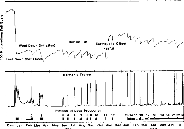
https://volcano.si.edu/volcano.cfm?vn=332010#bgvn_198405
The inflow-models for svartsengi now show near zero gain/slight volume loss, but all available deformation data still indicate slow inflation. I guess the models become more and more unreliable as inflow weakens?
Well that looks kinda close to the numbers needed for the next eruption, i guess it is timd to start paying attention to the grindavik cameras again
It means a trigger becomes needed, for instance an earthquake or another intrusion. That is unpredictable.
It’s hard to tell if it’s really stopped. It’s at a point now where the short term variations and measurement errors are larger than the long term trend. We need at least another 2-3 weeks before we can say anything for sure about the trend. Also, there’s modeling errors. These graphs try to isolate the ground deformation caused by magma accumulation from the overall deformation that’s caused by the plate motions.
Important to note is that the GPS trajectories have not flattened out. In other words the plate boundary is still in motion (beyond the normal background levels). I’m not so sure it’s the level of inflation under Svartsengi that’s the trigger for a new dyke intrusion. It could also be that the plates have to separate enough since the last event to create the conditions needed for a new dyke.
Juno has managed to measure the thickness of the ice on the Europa’s ocean. (If you are confused, we are talking about Jupiter’s moon.) It is 30 km.
Then there is water inside and submarine tidal fueled volcanoes on the seafloor alien space fish around volcanic vents
Send Nigel Marven down there in a sea cage and we will see if “space dunkleosteus” will appear…
I think some exoplanets coud be superhabitable
rocky exoplanets somewhat larger than the earth is around orange dwarf stars are huge intrests in astrobiology
A Super Earth moon around a Super Jupiter in a habitable zone of an orange star is also very intresting benefitting from tidal heating to runn the geological carbon cycle forever
Souch worlds orbits longer lived stars and stays geologicaly active for much much longer than earth will through mass and tidal heating. And may benefit from a much denser nitrogen atmosphere ( 2 bars ) to even out temperature extremes
Oh hello, swarm in Reykjanes… checkes cams…
It’s nowhere near Svartsengi.
That’s right. It’s near Nesjavellir geothermal plant. There’s a nearby injection well with the borehole pointing in the direction of the swarm. It’s 4km away, so maybe it too far away to be injection induced quakes. There’s also an old crater row right next to the swarm. Not completely unlike the Sundhnúkur crater row.
Anyway, swarms of this magnitude are common in the area. If we start getting quakes around M4 and higher, then it’s time to keep an eye open.
There must be a pocket of expansion going on around 6.7km deep….most likely hydrothermal? Drumplots show lots of rock fracturing events going on, but no sign of magma movement in the form of tremor or “wet” patterns to any of the shocks. Also, the areal coverage of the active seismic zone is not that linear, so I’m suspicious that the source is tectonic activity…though it can’t be ruled out that some extensional faulting is activating.
Given the number of shocks is now probably close to 100, something is going on…but is it volcanic magma that’s involved? It could be that a small pulse of magma has ascended into a water-rich section of the crust that’s in turn starting to pressurize/expand. Time will tell.
That would be about the locking depth of the reykjanes fault.
Today Katla/Myrdalsjökull looks interesting with five quakes within 15 minutes around 9 a.m. Three were M2, two M1.
Still continuing.
Iceland is today in general above-average active with earthquakes: Reykjanes Ridge, Reykjanes Peninsula, Snæfellsnes, Katla, Lanjökull, Vatnajökull, Askja and Tjörnes Fracture zone. Maybe the relatively calm weather allows more earthquakes to be detected, but there are also times with higher and with lower seismic activity.
Interesting that there’s “little” discernible GPS movement at HUSM. At ~5km east of the ongoing swarm, I would think there would be some sign of movement on the surface other than a “possible” westward and/or downward shift of a couple of mm since the swarm started…which can explained best by an expanding bubble of some kind to it’s west? So far, it’s only one data point and well within the normal noise, so we’ll need to further monitor the progression/cessation? of further activity to get a better sense of what’s going on. Personally, I’m rooting for a tectonic explanation since it might be the precursor to a new breakout sometime down the line?
Tephra deposits by E41:
https://www.usgs.gov/observatories/hvo/news/volcano-watch-when-it-rained-rocks-tephra-fall-during-kilaueas-episode-41?fbclid=IwY2xjawPpVdFleHRuA2FlbQIxMABicmlkETA0MVJVaklDRzAwRTI1dUhpc3J0YwZhcHBfaWQQMjIyMDM5MTc4ODIwMDg5MgABHh7ty_3VrMeGfJPrEyy2av-X3j-e0_OTjvzlnOhUVLqtPSVlyEhl3Azq52cS_aem_W0a2-6S02mnclF4w-QMBpw
This time exceptional westerly winds in upper levels of atmosphere carried the ash to the east, while usually trade winds push tephra towards the opposite direction.
A geological disaster in Sicily caused by sedimentary rock: https://www.dw.com/en/sicily-landslide-forces-evacuation-of-1500/a-75702595
https://en.wikipedia.org/wiki/2026_Niscemi_landslide
There are layers of sand above layers of water-proof clay. Strong rain from Mediterannean cyclones let the geology react. The mountains of the town Niscemie look like plateau mountains. Do we know, when these sediments were deposited?
Bárðarbunga just did a quake. It registered as M3.5, but the waveform looks a lot bigger. Should land upwards M5 after review.
The “specialist remark” has it at M4.1, but the lowpass response kept ringing for 15 minutes on a seismometer located at the tip of Reykjanes, so I imagine it would be a bit larger.
It’s now verified as a M5.3 quake at 2.5 km’s depth.
Quite a big one!
Congratulations to Tomas for getting it wrong! The M5 he predicted for February arrived one day early.
Well, I did say around February. I’ll try a bit harder next time 🙂
‘around’? A career in politics beckons
So they swapped the digits of the initial estimate:)
There’s a few aftershocks in the direction of the starting point of the Holuhraun dyke. Not a high intensity swarm, but still a bit interesting.
Congratulations for predicting this quake, Tomas.
The Surtseyan eruption of Home Reef Volcano (not far away from the HTHH volcano) continues: https://matangitonga.to/2026/01/31/home-reef
The eruption began in Mid-December, it releases mainly steam and gas plumes. The eruption is until now mainly phreatic, not effusive.
According to GVP Home Reef Volcano has Dacite magma. Is this a reason why the eruption is different to Surtsey’s lava show?
Mauna Loa’s shallow quakes during last month are more below the summit than in the years leading to the eruption 2022. They concentrate pretty much in the southern part of the caldera, where longterm summit eruptions occured 1940 and 1949: