This is a repost of a summary by Hector, of the previous round of Reykjanes eruptions, a millennium ago. (The post is not as old as that, though. It was written during the first Fagradalsfjall eruption, at the very start of the new fire season.) The discussion includes two of the three Svartsengi eruptions of 1240 that ended the previous phase. It is probably coincidental that the current phase starts close to where the previous one ended. It seems eruptions sites are almost random across the peninsula. Fagradalsfjall had not erupted for 7000 years before 2021, and would have been nobody’s guess of where the reactivation would begin. There is a certain unpredictability about the Reykjanes eruptions. And as we see now, that extends even to ‘will it – won’t it’. Enjoy Hectors’ historic tour de force !
Now that Fagradallsfjall has finally erupted it is clear that a new eruptive period has initiated in the Reykjanes Peninsula, we can expect many more eruptions to come in the following few centuries, but what should we expect? and what about the eruption that has already started?
The last time the Reykjanes Peninsula was active was during a series of eruptions, roughly in the 950-1240 year period. Although there were people around, there was of course no one to take scientific notes, so the information is very sketchy. In an attempt to fill the lost history I have looked at a couple of lava flows in Google Earth and tried to interpretate their origin. And how do I do that?
Volcanic landforms reflect the kind of eruptions that created them, for example the height of a lava fountain is about the same as the diameter of the top of the cone that it creates. There are also various types of lava flows, pahoehoe sheets, aa sheets, tube-fed pahoehoe, toothpaste lavas, raised lava channels and ponds, all of this together, and with the relationship between the various features, the volume and complexity of the lava flow, it can give clues as to how the eruption happened.
Before getting into the individual eruptions I should mention the two general progressions that fissure eruptions generally follow.
Two types of fissure eruptions
We are used to used to seeing Piton de la Fournaise, Kilauea, Galapagos, or Bardarbunga erupt, their fissure eruptions follow one general pattern. First, the curtain of fire, when a long fissure bursts into a chain of lava fountains and for a short time the highest eruption rates are reached. Then the eruption focuses into one or a few vents and stays there, the effusion rate falls exponentially until it stops, or it enters a prolonged phase of slow activity at just a few cubic meters per second. From a curtain of fire to a single vent is the typical sequence of a fissure eruption.
However there is another important end member, this is a somewhat rare type and not many examples come into my mind, but there is a big one, the Timanfaya eruption of 1730-36 on Lanzarote, in the Canary Islands. This is a very dramatic case, but that’s why it’s a good end-member example.
Timanfaya started from one single vent initially, but then over the following 6 years, the focus of activity kept shifting from one vent to another, countless times. By the time it was over there were many vents lined up in a row, so that it looked like a fissure, but no one would have thought that when it started. There was no clear reduction in activity either, it just kept going, a terrible deluge of ashes and lava with no end in sight.
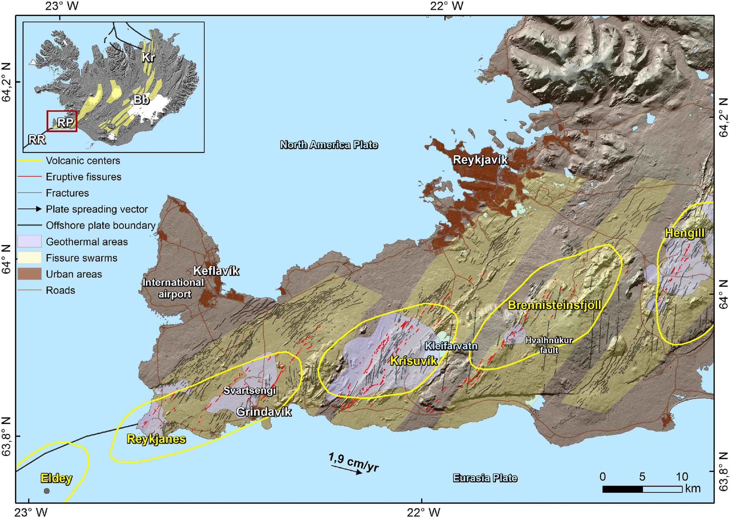
It’s not easy to tell apart the two types from looking at moss covered lava flows from ages ago, however, I do get the impression eruptions of Brennisteinsfjöll and Hengill may follow the Timanfaya type, whilst eruptions of Svartsengi follow the curtain of fire type, I’m not sure about the others.
And now, with that explained, we should start where the Reykjanes Fires started, with Brennisteinsfjöll.
Brennisteinsfjöll eruptions. ~950 AD.
There are four different historic lava flows in the Brennisteinsfjöll fissure swarm. All of them formed in slow eruptions, from fissures that were less than 500 meters long with one to a few active vents, and fountains that only reached up to 100 meters high at most. From what I’ve seen each of the flows must have been erupted in a period longer than a month.
Hellnahraun is an example of a very slow eruption. Lava moved inside lava tubes, it inflated from within and formed many small breakouts of glassy pahoehoe lavas. It was the sort of activity that was typical in the Pu’u’o’o eruption of Kilauea. Lava reached what is now the small coastal town of Hafnarfjörður, on the outer edge of Greater Reykjavik. Taking into account the volume of around 46 million cubic meters, and effusion rates that must have been in the range of lava tube eruptions, 1-10 m3/s, I estimate the eruption most likely lasted around a few months.

Example of pahoehoe lava breakouts. From Wikimedia.
Another nearby flow, Húsfellsbruni, was possibly the longest and most voluminous eruption of the Reykjanes Fires. It forms an extensive apron of lava flows that is extremely complex. It was hard to understand its origin story because at places there are as many as 4 or 5 flow sheets that seem to lie on top of each other. The eruption involved mostly channelized flows and aa sheet flows, but there were also lava tubes, ponds, inflation plateaus, and toothpaste lavas.
Toothpaste lavas, also called rubbly or spiny pahoehoe, are a higher viscosity form of pahoehoe. Although Reykjanes lava flows have a very low viscosity the cooling lavas within the core of aa flows can erupt again from breakouts and form fields of toothpaste lavas, these look a bit like a mix of pahoehoe and aa.

Lobe of toothpaste lavas formed in the Húsfellsbruni eruption, it is shaped like the roots of a plant.
The volume of the Húsfellsbruni lava flow is hard to estimate because of how complex it is, however I wouldn’t be surprised if it came close to or exceeded 1 cubic kilometre. This eruption I’d say most likely lasted one to a few years. There is also the question of whether the historic lava flows of Brennisteinsfjöll represent separate eruptions, or rather just stages in a long eruption with a shifting focus of activity.

Example of a lava tube skylight. Every Brennisteinsfjöll eruption had some of them. From USGS.
Svínahraunsbruni. ~1000 AD.
This eruption happened between Brennisteinsfjöll and Hengill in an unnamed fissure swarm. There are three lava flows that are considered historic, according to the geologic map I’m following. They lie close to each other with vents that line up.
Each of the flows issues from a fissure that is only 250-500 meters long. One fissure is unnamed and seems to have had only weak spattering and a very small flow. Two bigger flows issue from fissure vents called Nyrðri and Syðri respectively, and both had lava fountains that probably reached 50-80 meters high at some point, issuing mainly from 1 or 2 vents. Syðri erupted on top of Nyrðri.

Nyrðri craters feeding a lava channel. This eruption happened around 1000 AD. From Google Earth.
It is hard to know if they formed in one or multiple eruptions. If we follow the Timanfaya model it could have been an eruption with three stages in which the vent focus shifted, but it can’t be ruled out that they were different eruptions altogether.
I shall describe Nyrðri, the biggest flow. Most of the time the lava erupted from a single circular spatter cone, bubbling up or making low fountains that spilled into a lava channel 30 meters wide. Lava streamed down this channel, raised above the ground with flanks covered in shiny pahoehoe. The channel shifted its path a few times throughout the eruption. The lava was channelized for 2.5 kilometres, then it was distributed over a branching system of blocky aa lobes and toothpaste lava outbreaks.

Example of a raised lava channel with pahoehoe overflows. From Wikimedia.
Considering the three lava flows as stages of one eruption then the volume is 110 million m3. I thought eruption rates of 10-20 m3/sec were reasonable for its level of activity, that gives a duration of 65-130 days. This is a guess. The flows may have formed in separate eruptions, but still most likely the duration would be in the range of one to a few months.

Aa lava flow with a folded surface and toothpaste lavas around the edges. Syðri eruption. From Google Earth.
Eruptions of Trölladyngja and Krýsuvík. 1151-1188
Fire is reported near Trölladyngja mountain in 1151 and again in 1188. These reports probably refer to three historic age lava flows that exist in this area. Of these, Ögmundarhraun and Kapelluhraun were large eruptions. Each formed large lava channels running into the ocean in opposite sides of the Peninisula. The other smaller flow was short lived and may have been part of the Ögmundarhraun eruption; their fissure systems line up too.
These lava flows, as well as many other prehistoric eruptions of both Trölladyngja and Krýsuvík, are stronger than those of Brennisteinsfjöll and Hengill: they erupt curtains of fire with tens of lava fountains bursting at once over a length sometimes exceeding 1 kilometre, and very rarely some fountains can reach up to 200 meters height.

1984 Krafla eruption, the Kapelluhraun lava flow from Krisuvik volcano may have looked similar.
In the eruption of Ögmundarhraun intermittent fissures opened over a length of 9 kilometres, I don’t know if there was an initial phase of fire curtains affecting the entire length or if the various segments were activated at different times. The vents opened along the valley of Mohalsadalur, flooding the entire floor. Lava poured in rapids where the valley was narrow, and then dived below the smooth brilliant crust of lava lakes that collected where the valley was flat and wide. Lava entered the ocean in massive flows of aa lavas. It seems the system of winding channels extending towards the coast reorganized multiple times, so it was probably a lasting feature and a significant volume of lava must have ended up underwater.
In the late stages of the eruption activity had focused in a 500 meter long fissure, on the order of 10 fountains were playing to low heights, or some perhaps up to 50 meters, their streams merged into a singular mighty river slowly flowing towards the ocean 6 kilometres away. The flow broke into two branches, each half a kilometre wide, and entered the ocean 2 km from each other, amidst what must have been boiling seawater, dead fish, and towering columns of snow-white steam.

Example of an ocean entry like those of Kapelluhraun and Ögmundarhraun. From USGS.
It seems difficult to make any guesses about the volume or duration of Ögmundarhraun, other than it must have lasted more than a few days, but could have been much more, and that the volume must be more than 100 million cubic metres.
Eruptions of Svartsengi and Reykjanes. 1210-1240 AD.
We arrive to the last volcanoes of the Reykjanes Peninsula as we travel westward together with the migrating activity of the Reykjanes Fires. These two fissure swarms produce intense eruptions with curtains of fire similar to those of Trölladyngja and Krýsuvík, or even more intense. For example, one prehistoric eruption included a kilometre long unbroken curtain of fountains shooting to heights of 100-200 meters.

Example of a fire curtain, a line of fountains, which are probably frequent in Svartsengi eruptions, the lava flow is a sheet of pahoehoe which typically forms in eruptions of >100 m3/s. From USGS.
Svartsengi produced three lava flows, Arnarseturshraun, Illahraun and Eldvarpahraun, I will focus on the first two, which I think are parts of the same eruption.
Illahraun erupted from a 200 meters long fissure, but the eruption was very intense. An area of 8 km2 was rapidly flooded by a sheet of molten pahoehoe lavas, including the present location of the Blue Lagoon. The surface flowed as a mass of crustal plates carried by the molten rock below, as it moved the slabs clashed against each other lifting into broken ridges.
The cones that fed the eruption barely have any prominence and the flow is one simple sheet, this is all probably because the outbreak was very short lived. The total volume was 38 million cubic metres and eruption rates must have been on the order of hundreds of cubic meters per second, so that the effusion can’t have lasted much more than a few days. Illahraun however may have taken place concurrently with the opening of fissures along the same line to the northeast which fed the longer lived Arnarseturshraun flow.
Arnarseturshraun must have opened with a line of fountains and a rapid outpouring of pahoehoe lavas, although this initial stage is largely buried under later activity. The eruption rate declined progressively. For some time a raised lava channel kept supplying lava towards the north which fed a massive slowly advancing wall of aa lava, crustal plates from the initial lava flood as large as hundreds of meters across were rafted downstream and collided with each other raising up meters high ridges of rubbly scoria, much like tectonic plates that collide to form mountain ranges. Activity kept decreasing and some more lava channels were formed to the north, however activity focused more and more around the vents.

Large crustal plates in the Arnarseturshraun lava flow, they are separated by ridges of broken up lava. From Google Earth.
Because the ground is mostly flat, lava had ponded around the fountains of the Arnarseturshraun lavas, this evolved into three lava lakes raised slightly above the ground by overflows, the largest with a triangular shape and 200 meters wide. Small fountains and dome fountains probably played in the lakes and distributed lava over an intricate system of channel and lava tubes leading up to small lava flows nearby. It is clear that this must have been long lasting, more than a few weeks, but it is hard to know how long.

Example of a raised lava lake, similar to the lakes of Arnarsetur. From USGS.
Lastly the historical records mention some submarine eruptions offshore Reykjanes, or by the coastline. An eruption in 1211 formed new islands, called Eldeyjar, meaning islands of fire. An eruption in the winter of 1226-27 is said to have produced darkness at midday, it must have been an explosive phreatomagmatic eruption with ashfall. New eruptions happened in 1231, 1238 and 1240. This last event was the final of the Reykjanes Fires and then the whole region entered a prolonged dormancy that was only broken now that Fagradallsfjall has erupted.
The future
The story of older eruptions can help understand what is to come. I can now make some general predictions. For example, if Reykjanes of any offshore volcano erupts it might be explosive phreatomagmatic and ashy, if Svartsengi erupts it will start with a very intense eruption with curtains of fire and be followed by an exponential drop in effusion rates, but if Brennisteinsfjöll or Hengill erupt then expect slow eruptions at near constant rates.
Problem is that the current eruption doesn’t belong to any of these volcanoes, in fact it opened in a very strange location and it turns out the magma is coming straight from the mantle. According to scientists this is quite extraordinary, and extraordinary magmas bring fantasies of extraordinary eruptions.
There is one very rare type of Icelandic eruption known as a lava shield, or a dyngja. These eruptions are thought to feed from primitive magma from great depths, and they are not associated with the shallow magma chambers of central volcanoes that feed the large fissure eruptions. Many commenters have already been discussing that we may be witnessing the birth of a shield volcano, Irpsit I think was the first to mention the possibility. The reason to think this is that the magma is from the mantle and the vent has opened outside the fissure swarms. A shield is a huge eruption that produces multiple cubic kilometres and lasts decades, it is a slow tourist-friendly eruption with lava tubes and inflated pahoehoe flows. The magma coming from the mantle is certainly a good sign, the last time an eruption came from the mantle was in Mayotte… 5 km3 or more, and still going. But while it’s true that shields erupt magma that is very primitive, it is not true that every eruption that brings out primitive stuff is going to be a shield.

Sandfellshæð, a lava shield of the Reykjanes Peninsula, formed 14,000 years ago, it seems to have had a lava lake or shallow sill intrusions, or more likely both, at its summit. It is cut by normal faults from many grabens that form when dykes intrude. From Google Earth.
So far the Fagradallsfjall eruption has followed a similar pattern to those of Brennisteinsfjöll and Hengill, a short fissure eruption at a slow steady rate. If it is similar in the other respects, the eruption should probably last on the order of some months, but it could also last years if it is a large eruption like Húsfellsbruni, or even decades if it becomes a dyngja. If it is Timanfaya-like then dyke activity may keep going and new vents could open elsewhere as much as months or years from now.
We shall see what comes to be of Fagradallsfjall, but in the meantime we can understand the eruption from a much more full perspective knowing about previous fissure eruptions of the Reykjanes Peninsula in their rich variety.
Hector


.jpg)
I am also quite impressed since it would give all sorts of abilities in my field of geophysics assesments of deep geothermal fields.
I should really one day have to sit down and have a chat with her.
For those interested in the new DAS technology, please see https://eos.org/science-updates/sensing-icelands-most-active-volcano-with-a-buried-hair
Ferreting away for watching next week when I am a tad less busy with mundane things, like marrying off a friend.
I somehow have a new profession as a wedding planner.
I am thinking vodka-volcano and a couple of tanks to keep the guests in order.
Weddings should have those two things.
I had a tequila-volcano at mine after all. (tequila-fountain, but I think of it as a volcano)
Oh dear you know what is going to happen Carl? this beastie of a volcano will decide that the day of the wedding is just the time to make an appearance..
Ah! Now we know why this eruption is dragging it’s heels. all Carl’s fault.
Fagradalsfjall 1 took from 24th February 2021 to 19th March 2021 to reach an eruption (c. 24 days) so we could have to wait a tad longer.
Laughing.
So Merlot if that first eruption took 24 days and this ones volcanic unrest has taken from 26th October until now then this latest episode is due to erupt tomorrow. 🙂 😉 😉
And before anyone jumps on me, that was said totally tongue in cheek as clearly every eruption will be different. Be nice if it was more than wishful thinking though.
Friday 17.11.2023 06:35:56
4.5 km
2.3 magnitude
90.08 %
3.4 km NNE of Grindavík
I guess this quake is in the area now considered most likely to produce an eruption? I.e. Just North of Hagafell in the Svartsengi area.
Now revised:
17.11.2023 06:35:56
5.1 km
3.0 magnitude
99.0 %
3.7 km NNE of Grindavík
It is pretty much at the feeder from the sill into the dyke, as such indicative of pressure building up.
The DAS-plot of the quake:
Nice to see the propagation down the fibre. It first arrives at the top horizontal line, which is the point closest to Svartsengi power plant, then progressively reaches lines further down the fibre. With this technique, you get a drumplot, spectrogram, or any other analysis you can get for a standard seismometer, but for every single point along the fibre, down to 25cm spatial resolution for the sampling points.
ETH Zürich mentioned in the chat what equipment they are using, and if you’re interested in the details it’s this one: https://silixa.com/technology/idas-intelligent-distributed-acoustic-sensor/
The speed along the fibre seems something like 7 km/s. Typical for a P wave
It seems about right in this case, but you have to be a bit careful in general. The slope in the waterfall plot depends both on the wave propagation speed and the angle of arrival.
To make it even more complicated, the fibre is not laid in a straight line. It has a kink at about 40% of its length (measured from the power plant). Finally, the quakes are of local origin, so we can’t expect the propagation to be a planar wave. In radio lingo we are in the near field of the sensor array. In this case it’s a good thing, since it makes it possible to determine both direction and distance. Had it been a linear array and planar waves, only direction would be possible.
earthquake_map_past_week.png
Kilauea is still restless. It is basically doing exactly the same thing as the dike under Grindavik, only in this case the question is nit if it will erupt, but where will it erupt… 🙂
It seems the SWRZ is becoming a formidable part of the magma system now. And the ERZ connector is really flaring up too, just as well it appears to be blocked or magma may have found its way back into Puna far sooner than would be expected. A SWRZ eruption seems likely, and may be inevitable with this setup, although another short summit eruption or 3 could easily occur before that too.
🙂
Chad is it possible that the pahala swarm area that could be a will complex be connected with the swrz, or is it impossible?
Sill complex yes but it isnt connected to the shallow bit of the SWRZ, probably. But it probably does connect to Kilauea still.
Its still pretty uncertain exactly what the quakes under Pahala are. They are magmatic but thats as far as is knkwn for sure.
My theory recently, is that the swarm is magma that would have gone to Mauna Loa intruding the deep fault zone under the island. Perhaps normally this would do nothing ir accumulate until it has a huge deep sea eruption, of which many are known on the ocean floor around Hawaii some of which make Laki look pretty miniscule.
The thing that makes this different is that the fault zone is pierced by Kilaueas plumbing, so the Pahala magma will probably escape there.
Kilauea might not be what it appears too. Im going to get speculative here, Hector brought up some very interesting data that Kilauea erupted the same transitional alkaline basalt as Kama’ehuakanaloa (Loihi) for an extended period around 1500 years ago while Mauna Loa was particularly active. Additionally Kilauea is apparently only slightly older than Loihi, despite its much larger size and being on land. I think there is a distinct possibility that Kilauea has been a parasite of Mauna Loa for millennia and managed to grow far larger than it was supposed to by now if left to its own devices Only when Mauna Loa gets highly active does Kilauea reveal its true nature. Kilauea still has yet to fully dominate the plume and enter its proper shield building stage, hence its nearly nonexistant topographical prominence and small volume relative to its size and how active it is at present. O e very curious bit of data I remember reading about is that Mauna Loa – composition magma was erupted by Kilauea in the late Pleistocene, around 21000 years ago if I recall correctly. That may have been when magma began to flow from Mauna Loa to Kilauea, and perhaps by extension when the Pahala swarm first appeared but we will never know the answer to that.
Sorry Sill complex, not will. Stupid predictive text.
If we had the current digital instruments, how early would we have noticed signs of Eldgjà and Laki before? How would the 10 years before the event look like with modern monitoring? How early before Holohraun did they predict the size of this eruption.
I think Carl is the one to answer that question, he is very good at predicting when the lava begins to flow and he was also correct when it would end too.
About halfway through the Holuhraun eruption it was possible to calculate the final size based on the parabola of the height measurement in the caldera and also the rate of seismic moment release due to the caldera collapse. Before that? We knew it was preparing for an eruption in about 3 months in advance, and at that point we could not say when or how large.
Was in the months/years before Holohraun something different to an ashy summit eruption like Grimsvötn’s recent onces? Bardarbunga in most cases does ash eruptions like Grimsvötn, so that they maybe have similar signs like Grimsvötn. Was there 2014 any unusual deformation around Bardarbunga that was different to typical summit eruptions?
Laki and Eldgjà were larger than Holohraun. Can we estimate that they had certain unique precursory signs that were different than usual summit eruptions of Grimsvötn resp. Katla?
These are good questions and ones I frequently ponder myself. I have an intense fascination with these recent historical giants and their precursory activity, and what that would look like today.
I would guess that for Laki and Eldgja there would be significant magma accumulation in the crust, so possibly an anomalously elevated area although maybe not an obvious one. Eldgja probably formed Katlas current caldera, so it may have been taller before, although its not really clear.
It is uncertain how long it would have taken, if neither volcano erupted at all for a few centuries that would probably do it but both were active before, especially Katla was more active before Eldgja than now… so most likely the magma was accumulating in deep storage for millennia, safely out of reach of the shallow activity of the central volcano until it couldnt be contained any longer.
But the best answer I can give is that most likely we would probably have no idea until it happens. No one predicted Kilauea in 2018. Holuhraun was predicted but it wasnt exactly a pinpoint accurate job, not to downplay the tracking done. We were looking at one of the biggest Icelandic calderas engaging in a rifting event when most of its prior eruptions were moderate to huge in scale, not a hard bet something big was in the works. But still no one eally knew, thats the key point.
Were Edlgjà and Laki similar dependent on Katla resp. Grimsvötn as Holohraun depended on Bardarbunga? Can fissure eruptions also occur more independently from the central volcano than Holohraun was? Holohraun depended on Bardarbunga so much that the magma evidently came from the central magma system towards the fissure system. But there may also be cases when magma comes up directly from deeper fissure sourced (like f.e. Mauna Ulu did).
I would assume it is possible for direct mantle eruptions to occur in the fissure swarms of the Vatnajokull volcanoes. But the bigger eruptions need a magma chamber of some description, mantle decompression cant explain the eruption rate of the big fissure eruptions, otherwise there is no mechanism to turn it off and we would have got another Laki back in 2021.
https://twitter.com/Icevolcanx/status/1725461103461716246
Could a magma dike be found under Reykjanesbær?
Reykjanesbær (with Keflavik airport) lies outside the fissure swarms. Grindavík lies within a fissure swarm, as do easternmost suburbs of Reykjavík, Kópavog and Garðabær
More: https://visindavefur.is/svar.php?id=85792
https://twitter.com/Icevolcanx/status/1725485480525853020
For at least several minutes, ending just a few minutes ago, my access to this site was completely blocked. During a crisis situation whose public tracking mainly occurs here.
I think I, and anyone else whose access was blocked, am owed an explanation.
You are assuming you were blocked. The site is publically available and if it’s not then it will not be personal, more likely an infrastructure issue.
I was unable to access the site, the same as you, but would never demand an explanation, more a hope that whatever is causing the issue is resolved as soon as possible at the convenience of the site owners.
I also found I couldn’t access it for a while this morning. I just thought Oh well check out something else for 30 mins and try again later. It worked then.
I liked the Queens motto. Never complain, never explain. It makes life so much less stressful.
absolutely – just one of those things, thankfully I was driving down the M5 so not aware that I couldn’t get on the site
Good God, could you possibly sound more entitled if you tried?
Free clue: you’re not “owed” jack sh!t 🙁
Nobody owes you anything.
Everyone, let’s not pile on B. Bound. Cultural and language differences could be in play and the comment may not have been as entitled or demanding as it came off. As my mom always told me for situations like this, if you have nothing good to say, don’t say it all. Let the site owners respond in a professional manner. This world could really use love and understanding instead of anything else right now. I love you all and most importantly I love volcanoes and this site. 🤗
I would have to disagree on two grounds:
1. The poster who made the comment has ‘form’; during previous eruptions, I’ve seen them deploy what I can only describe as ‘conspiratorial’ reasoning to explain webcam outages, glitches, or delays.
2. They state “During a crisis situation whose public tracking mainly occurs here..” – errr this is a site where (mostly) amateurs contribute observations and discussion, some to a very high standard. But ask me, or any other professional working in this field, and we will always tell you the same thing: for reliable, actionable information about any volcanic crisis, go only to the relevant agencies with responsibility for the area – civil defence, whatever geological or volcano observatory or agency is responsible etc. The notion that Volcanocafe, however admirable and interesting, is the place where “public tracking mainly occurs” is risible; and dangerous.
Go to IMO or Almannavarnir if you want accurate information.
I agree, go to the actual sources responsible for protecting the public. You are giving a good reply in that sense. I was simply asking people to reply with civility.
I know nothing of the previous posts during past eruptions.
I will go back to lurking. Sorry for speaking my mind.
Nothing wrong with speaking your mind 🙂 its what this site is for. No one here is a volcanologist, even Albert and Carl have no more say in the matter than you or I, we are all here out of common fascination of the same subject.
Your contribution is appreciated. We know that people get emotionally involved with volcano watching and can get upset when things don’t work. We try to do the best we can but we don’t promise perfection. We don’t accept abuse of others, but can live (somewhat) with criticism of ourselves. And Mike is completely right: for accurate information and facts, go to the professionals. The discussion here is often at a high level and anyone can learn a lot from the comments, but it is also speculative. We try to predict the unpredictable – accountable professionals can not, and for good reason. This site is a Calvin and Hobbes of volcanoes. (Calvin of course is Carl.) (O dear – I just lost my adminship here.) We are the people who postponed the first Reykjanes eruption by a year (did you like that story?). We are the people of the funcanoes.
(I’ll get my coat)
I think it will erupt 21 Nov – 2026.
Due to the release of tension, it is likely that the magma will have an easy way to the surface, and therefore it cannot be assumed that eruption turbulence will be visible on the meters ( measuring devices ) before the eruption begins.
https://twitter.com/DottirGongu/status/1725402493310456311
Sounds like the eruption in July, lots of uncertainty untill it just started.
Yes…
It’s possible that the eruption begins like Mauna Loa 2022 with an initially long Curtain of Fires. Reykjanes and Svartsengi belong likely to this type of fissure eruptions. Maybe it need to collect the satisfying pressure before this happens. The rocks above resist the upflow of magma and have to be overcome by enough pressure Newtons. When the point of enough pressure Newtons has come, the fissure may very suddenly open.
Maybe not now. If it erupted last week when the dike was extending then yes but an eruption today would probably be similar to the one in July. It is likely future intrusions in this rift will erupt in that early stage though, given the 2nd and 3rd Fagradalsfjall eruptions erupted in a fraction of the time of the original dike and tended to go much more vertically up compared to sideways.
So basically an eruption now will be fairly slow and restricted, though possibly visually impressive. But the next one could get scary.
https://twitter.com/ICEYEfi/status/1725509643152048574
Our #InSAR analysis is supporting the Icelandic Met Office in identifying where in the Reykjanes Peninsula the upcoming volcano eruption might happen.
👉 Read the full story from ICEYE’s Valentyn Tolpekin: https://hubs.li/Q029fpS80.
Am I seeing maybe 6 moving faults in this image ?
After looking at that picture closely, all I see is alternating color bands.
EVERYWHERE!
PLEASE MAKE IT STOP!!! 🙂
Luis, I tried to do the best that I could do on overlaying the inSAR image with the topo of the area. Here’s what I have – and
and 
Wow very nice! Thanks!
If you want to HEAR how the Nov 10th quakes sounded like (if sped up) then this is for you:
https://arstechnica.com/science/2023/11/earthtunes-app-lets-you-listen-to-icelands-intensifying-earthquake-activity/
To me it sounds like thick raindrops on a flat, bendy sheet of metal or plastic.
Does anyone know if there is some way to listen to seismic data in near-realtime?
I know realtime isn’t possible because audibly anything at below 20 Hz would just be total silence to our ears, so it needs to be sped up by several factors.
I tried the Earthtunes app but it seems broken for me, won’t download most samples and the ones I get are really short.
Audio/dsp nerd here. Yes, it’s possible. You don’t simply speed up the signal, but you scale the entire pitch range. Say you start with a signal in 0-10 Hz, it is possible to stretch that band to any other band, say 0-20000 Hz. And you can do it in near real time with modern algorithms. Of course, there are various trade-offs. You may have to sacrifice latency quite a bit and you may have to accept artifacts in the signal.
This is essentially what DAW plugins like autotune do today when they “correct” the pitches of song tracks. This is done in real time.
Having said that, I just looked at the article and it seems to me that they are simply resampling everything. This cannot be done in real time, because an hour of material might produce a few seconds of output. This is not how autotune works.
Cool thought! I’d really like to listen to the seismogram in realtime. I like some static noise in the background anyway, to smooth out any disturbing noises like .. neighbours. Ugh.
Coming back to this “how does an eruption look like on the DAS seismogram”:
https://twitter.com/DottirGongu/status/1725170530150400415
The DAS seismogram is streamed here: https://www.youtube.com/watch?v=MUt7Lz4y-jg
I realized that it will NOT look like the comparison image. Not even close! The comparison image has frequency mapped vertically, on DAS however the vertical axis is NOT frequency, it is distance! On DAS, the colors encode the ‘intensity’ (amplitude?) of the shockwaves, and frequency is – at best – seen over time. You can see that in some of the bigger quakes as the colors seem to wave up/down a little (between warmer and colder colors) after the initial shock.
I asked on the stream’s chat and had this confirmed.
 ?w=800&ssl=1
Someone also said it’s not set up to register tremors according to ETH. So we may not see the tremors shown in this picture:
I guess we’ll just have to see how much of the above image comes through in this DAS setup.
If something BIG happens I’m sure it’ll be visible on the graph in some form.
If you see “distance” as wave length, you can just take the speed of wave propagation (speed of sound in the rocks) and divide it by “distance” to get a frequency. Same unit: per second.
So, in that the tremor was ongoing and the source was near one end of the fiber; and there was a point source near the middle of the fiber that abruptly produced circular waves, whose impingement time on different segments of the fiber resulted in those purple hyperbolas. Probably a quake, given “point source” and “brief impulse”.
If the tremor source moved away from the fiber the striped pattern would both get vertically broader and fade; moved toward, the pattern would get narrower and brighter. If the quake had occurred farther away the hyperbola would be broader, approaching eventually a vertical line, and weaker, and had it occurred closer the hyperbola would be narrower, approaching a sharp-pointed < if it were right under the fiber, and darker.
Am I getting that right?
Also: the vertical-ish bands in the hyperbola would be spread out more for a more distant source, and bunched together more for a source closer to the fiber, as the P, S, and surface waves, traveling at slightly different speeds, would have had more (resp. less) time to separate from one another before reaching the fiber.
I would give one major caveat here; where we have volcanic earthquakes, involving magma or fluid movements, the point-source assumption isn’t always valid; EQ mechanisms can be non-DC, including deviatoric high CLVD moment tensors – all likely to be due to EQs involving a *volumetric* change.
I haven’t seen any MT solutions for events in this swarm yet – haven’t been playing that close attention – so don’t know to what extent that might be happening here.
I see the US Navy transmitters are flashing again.
So these are not huge Daleks then, I was wrong.
No. They just control them.
That’s just made my Friday 🙂
Yjry don’t control Me 🙂 lol
I’ll call the volcano doctor
No quakes now?
Is it the quiet before the Fire?
Maby… they started again but very few…
I’m sure the Fires will begin when I’m offline …
For a long time, it was believed that most magma tunnels originated at great depths & propagated in a mostly ▌ direction. This has changed. There is nothing against magma tunnels being able to travel ▃ in the 🌐crust, even long distances
https://twitter.com/DottirGongu/status/1725564009150108060
Is this true? We had a very long-distance horizontal dike in Holuhraun for which the direction of propagation was well predicted (albeit after the fact) and similarly there was a very very long dike known in Ethiopia, so long that it caused an unrelated volcano on the way to erupt when its stale magma chamber was heated by the passing magma dike. So I am not sure what this refers to?
The original article…
https://www.visindavefur.is/svar.php?id=85792
Thanks. I had to run this through translate (although I know now what a Kvikugangur is – and it isn’t a mercury gangster). So ‘for a long time’ means before 1975. Good article.
😀
I think some scientists still treat dikes as mainly vertical intrusions, from what I’ve come across in articles, despite the wealth of evidence against it.
With the advent of InSAR, and recent events like Bardarbunga 2014, Kilauea 2018, Ambrym 2018, Taal 2020, Nyiragongo 2021, and the ongoing Reykjanes Fires this mindset will hopefuly disappear.
What was the volcano in Ethiopia? Sounds like something i’d enjoy a bit of digging into while we wait for reluctantus eruptus
Manda Hararo-Dabbahu, it’s certainly worth looking into. A dike intrusion series that involved more magma than Holuhraun (2.5 km3 going from memory) and kickstarted a series of eruptions and intrusions in the Afar-Arabia area that involved six different volcanoes (Manda Hararo itself, Nabro, Dalafilla, two Red Sea systems, and Harrat Lunayyir)
Great stuff. The Erta Ale region is truly monstrous, a flood in action (not all basalt)
Yes, that is the one. It is the largest observed dike formation I am aware off, at 60 km long. There was 8 meter of rifting in one week and 2 meter of subsidence. The magma dike came from Ado’Ale and it caused a completely different volcano, Dabbahu, to erupt
The Skaftar Fires dike appears to have done the same thing, setting off Grimsvotn and Thordarhyrna but sourcing most of its magma somewhere else. The commonality: divergent plate boundaries run through both sites.
The Holuhraun dike did something even weirder, as it seems to have intersected both Barðarbunga and a small tuya to its north, while arcing around in an over 90 degree turn and heading toward Grimsvotn before reaching the saddle halfway there and dog-legging another 90 degrees and zipping out toward Askja. Halfway there it hit a local minimum of the terrain and erupted.
One thing is clear: dikes propagate horizontally as cracks or tears, like a run in stockings or splitting wood. If there’s a grain it will follow that, or else run perpendicular to the direction of larger-scale tensional strain. An initial vertical intrusion from below starts this, like a chisel, or the head of an axe splitting wood, but once the tear is initiated it propagates laterally in both directions until it hits an obstacle to further extension.
A zone of compressional strain can furnish such an obstacle, as can a tougher-to-break rock type. (The Skaftar dike was not stopped by the “knot in the wood” of the Laki edifice likely because the latter’s roots weren’t a large enough obstacle and/or were offset a bit from the dike, and the edifice proper just sits on the surface above the top of the dike.) If a dike has been propagating downhill, a change to uphill will also stymie it.
Once an obstacle is encountered, propagation will usually stop, except in the case of downhill propagation reaching a saddle in the terrain, where it may make a ninety-degree turn instead. Pressure may deflect it or stop it before it intrudes an actively inflating volcano but nothing stops it intruding a volcano that is not actively inflating, and it can remobilize mush in the latter’s chamber.
The magma that acted as the chisel to start the crack intrudes the crack, and pressure from it may assist the crack’s propagation, but tension stress being concentrated at the growing tips of the dike is the main driver. In the absence of such tension intrusions just go up vertically to the surface, or pool below it in sills. Dikes require tension, and big ones require an extensional tectonic setting, or at least micro-tectonics like the slumping flanks of the large Hawaiian edifices. Short radial dikes around a volcano summit exploit the local tension from the volcano’s own inflation bulging the landscape. (The bulge can be thought of as the top portion of an inflating balloon, so its surface is under all-directions tension; what breaks the symmetry here is gravity, so the dike propagates downhill, which makes it radial in direction.)
Cone sheets and ring dikes are a different thing from regular, linear(ish) dikes. The former are intruding preexisting circular faults, usually created in a past caldera collapse, and the latter result from an undermined roughly-circular chamber roof exceeding the shear strength of the rock where it attaches, unzipping along an outward-dipping fault, and dropping straight down under gravity, with frothy buoyant magma rising up around it. There has to be a pre-existing eruption of magma to remove volume from the chamber and undermine its roof. That’s why there were ongoing smaller eruptions at HTHH and Krakatoa shortly before the big kablooeys. Bardarbunga’s chamber was too deep for Holuhraun to trigger this process, so a tall cylindrical plug of rock above the chamber pistoned down and its weight lent power to the ongoing flank eruption instead. If the ring fault around this plug got intruded, it wasn’t much. It didn’t make the kind of short, outward-dipping ring fault needed for a runaway collapse.
Currently there is also an economical and financial crisis. The banks are not very helpful for Grindavik’s suffering people: https://www.mbl.is/frettir/innlent/2023/11/17/lilja_osatt_vid_vidbrogd_fjarmalastofnana/
And there is already a housing shortage…
What? Grindavik has less then 4000 residents. This is a very small town.
Iceland has fewer than 400,000 people. Grindavík is not a large town in absolute terms, but relocating one per cent of your national population on short notice does require some effort.
Maybe I’m just tired, literally and of waiting. Over the past hour or so I noticed what I haven’t seen on the DAS spectrum the whole day. Or perhaps I missed those. These are faint quakes, seemingly. I may be jumping on those because I had the graph run on my phone as opposed to my iPad so these often very faint “waves” are just more noticable on a smaller screen. I’ve seen maybe 15-20 of those within the past hour. Again, I’m tired, so I’m probably just looking for ANYTHING at this point. 🙂
Some are even fainter than these actually.
Forgive my lack of awareness.
What is DAS and why is it relevant to predict an eruption ?
What new signs point to tomorrow possibly being the day?
https://eos.org/science-updates/sensing-icelands-most-active-volcano-with-a-buried-hair
I read the link and now I know the wonders of DAS
Is this real time.DAS data from the Reykjanes/Svartengi volcano? Where can I see real time data?
Wow that’s a cool article
can existing internet fibre optics in Grindavik have a UI plugged in at one end and be used to measure the current event ?
I scrolled back for a while and counted about 15-ish of those within the past 20-25 minutes, pretty regularly also.
Some appear as just a faint green but vertical line of greenish-tinted blue in the center of the graph because the noise on top and bottom ends eats them up.
Someone needs to get the beam forming algorithm up and running.. raw data isn’t enough See https://agupubs.onlinelibrary.wiley.com/doi/full/10.1029/2021JB022358 and scroll down to section 4.2.3 Beamforming. If this can be done, a fairly accurate location for these microquakes can be found.
I think tomorrow is the day. Next to Hagafell. Perfect view from the Husafjall cam.
I’ll put 20 on it.
Na-ah! When you wake up, it’ll be fountains all over and you totally missed the great show because you wouldn’t stay up until 3:21 AM. 😀
I have a football game at 10am so there’s no chance. Too old for that now!
I think Monday evening at about 7pm…. when next storm arrives, rain, clouds, wind and darkness….that’s when the dragon shall emerge!
Wednesday Morning, 3 A.M.
Three tracks from that wonderful Simon And Garfunkel album tell me that will be the case…
what we are enduring at the moment (“The Sounds of Silence”) together with “Go Tell It On The Mountain” and “You Can Tell The World”. It’s obvious, surely? Well, as obvious as those stupid clues they used to give on 3-2-1 back in the 1970’s and 1980’s.
Yes, the over 60 year old crew need their sleep! With the live stream cameras, we usually get to wake up from our naps and review the last 12 hours.
Macusn
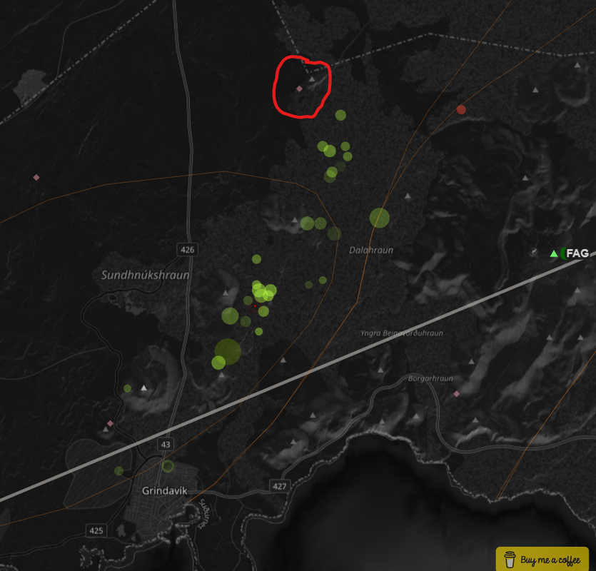
I put a red star on the topo map posted earlier where the maximum stress seems to be.
I don’t mind these long waits as I learn so much from the comments. Hi Albert! That is one long dyke. It’ an area I haven’t spent much time reading about. The large volcanoes, yes ‘ but I haven; given the whole system mch thought. Something for me to do in the near future when I am a bit laid up. Not looking foward to it but needs must. Tomorrow cataract surgery in Rught eye, naybe after my typoes will improve lol!!!! This surgery will not lay me up so will be peering with a very blurry one eye for a few days and you ccan bet the eruption will happen then!
Good luck with your surgery tomorrow, and very speedy recovery, Diana.
Seconded!
Thirded!
Fourthished
Best wishes for tomorrow Diana. Be careful of the blurry eye though. I can’t give a prognosis for your surgery but I guess Sunday morning for the eruption around 3 to 4 km NNE of Grindavik. It dare not erupt tomorrow, although the extremely small and sparse quakes are now ringing alarm bells. Tomorrow afternoon I am looking after 2 very young grandkids, one still a toddler so I will have no chance to watch anything except kids! So it cannot dare erupt before Sunday as I have had a very stern word with this very irritating toothpaste tube of magma, Anyway it cannot erupt until Carl has got his friends wedding finished with.
Good luck!
Hi DalekDiana,
I wish you a speedy recovery from your recent surgery. While you emulate the Daleks with mono-vision, let me tell you about my shocking encounter with a real Dalek long ago and far away.
Back in 1970, during my gap year, I was working at a Yorkshire Dr. Barnardo’s children’s home located in a converted mansion. I needed to borrow the bicycle that was kept in one of the old carriage houses. It was dark in there and totally cluttered with old toys and junk. I flipped on the light, a single, dim 40-watt bulb. In the gloom, not 10 feet away and facing me was a real Dalek! A jolt of adrenaline surged through my core and took my breath away.
Yes, it was a real prop from the BBC. When they had finished shooting and updated the design, some of the early props were lent (given?) to Barnardo’s to entertain the kids and for fund-raising purposes. Having outlived its usefulness, this one was left lurking in the gloom to scare the wits out of the unsuspecting, like me.
Thank you for the story. It made me smile. However alarm bells are einging . Are you sure it was a prop and not s REAL hibernating Dalek? I worry it may be the first of many, collecting for an offensive on Lancashire. I live near the Yorkshire border.on the red rose side!!!!! For those who are newer to Volcano cafe. Years ago there was a webcam focusing on Hekla with an object on the webcan that was possibly a monitoring station, It was nicknamed The Dalek , The sheep were also observed mustering around it often, Hence the sheepy references.!!!! Happy memories.
Happy memories indeed. I hope your surgery went well, Diana.
Hi Diana!! I hope all goes well tomorrow. I don’t mind the typoes, it’s just so nice to see you here!
Diana, I really hope for success in your eye surgery. I’m so glad you’re back to commenting on the cafe. Brings back many memories.
Professor Shawn Willsey was discussing the SV26 borehole and the rock lithography in relationship to the stall of the current fissure dike. If you refer to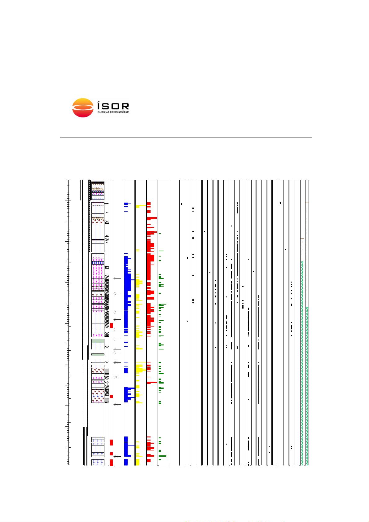 diagram, you can see what rock layers are in the region. His guess is that the magma just cannot make it through the last (1000 ft or so) of rock layers. From the well log a 14 ft layer of glassy basalt exists at the 398-412 meter depth. That would be hard to penetrate. Document cited is https://docslib.org/doc/12528607/borehole-geology-hydrothermal-alteration-and-structure-of-well-sv-26-in-the-svartsengi-area-sw-iceland
Never say never! I have said never so often, and always been proved wrong eventually. Not scientific I know.
(Never say always)
hahahah touche. 🙂
That’s the worst possible scenario, isn’t it?
Large quantity of magma trying to move up, finding a “hard ceiling” that it can’t penetrate easily – until the pressure becomes too much and it finally forces its way through… maybe in a more dramatic manner than if it’d found a “softer” route?
Perhaps that’s why Fagradalsfjall 1,2 & 3 were on or near previous hills. Less of the comparatively recent hard lava layers and weaker older edifices?
Long time lurker and even longer time berzerker when it comes to volcanoes. I have research experience but not in geology. Thanks B Bound for helping me better understand how the dike was formed. I have visited both Campania and Hawaii but my only basalt frame of reference is the latter. I am struggling with different terminology used at different sources. Why it is called a dike when there is a substantial horizontal component running well north of Grindavik all the way down into the sea and it is just below the surface (~500 meters)? I see maps of the Reykjanes Peninsula with long fissures from previous eruptions marked by red lines trending SSW-NNE. What would the dike look like on a map from the vertical perspective perpendicular to the trend?
At the HVO, if I recall correctly, a sill connects the magma supply from the plume south of Pahala to the magma chambers underneath Kilauea and Mauna Loa. From there, magma is supplied through horizontal connectors to the rift zones as has occurred recently on Kilauea’s SWRZ. A dike most often means a vertical magma conduit, as in from Kilauea’s East Rift Zone to Puʻu ʻŌʻō, or from the main magma chamber to Halema’uma’u more recently.
What am I missing? At least it’s not any harder to spell or pronounce Icelandic volcanic fissures than it is for Hawaiian craters…
So… while we wait.. memories of Grindavik. A friend of mine, a technologist at JPL, often went to Iceland to support SLR missions (Side Looking Radar). When he found that our family of nine was going to visit Iceland, one of his recommendations was a restaurant in Grindavik. Café Bryggjan. All-you-can-eat lobster bisque. As it turned out, there was a limit. Nonetheless, it was awesome. One of our many great memories of Iceland.
Btw, if there were a contest on guess-the-eruption-start, I’m in for Nov. 20, just after midnight.
We’ve been listening to this rather wonderful series of plays on Radio4, ‘Hulda’s Cafe’… ‘By Tiffany Murray. Five tales from Grindavik, a place of volcanoes and earthquakes, and apparently, the happiest town in Iceland. Read by Rachel Stirling.’
The main protagonist lives in Grindavik. Lots of volcano action. Very enjoyable but bittersweet now. First broadcast last year I think. https://www.bbc.co.uk/programmes/m001brjm
thanks Marinecreature – I will have a listen to that
i just love Your “Ladybunion” handle…. wish i’d thought of it.
Thank you all for your kind wishes. I have had more time on my hands (and sleepless nights) so I am back to commenting but I never really left this lovely group of Volcano fanatics. Whilst we wait I am looking forward to the rash of entertaining comments that tend to appearabout stopping the greenhouse gases from the volcano and sheepy methane gas from the icelandic sheepand horses.::)
Seems to me that the ideal solution to the CO2 issue is to legally require the advance purchase of carbon offsets. This should prevent any eruption (and thus CO2 emissions) due to volcanoes being notoriously cash-short.
Best wishes on the cataract surgery. My mom had that done, and was very happy with the results, plus found the procedure itself far less unpleasant than she’d feared.
Name me three carbon offsets guaranteed to sequester carbon for >20,000 years.
Possibly injecting CO2 into wells (but these can leak and are probably already full of detergent liquid). Dropping carbon torpedoes into deep sediment above a plunging slab. The what? Trees burn and are really carbon neutral. Bogs dry and burn. Not easy to find any guaranteed to survive war pestilence and plague situations.
Ah, but in my use of carbon credits, it really doesn’t matter, because their won’t be any actual purchase of said carbon credits. As I mentioned, volcanoes are notoriously cash-short, and thus unable to afford the purchase necessary to erupt. .
It’s a 100% effective means of preventing volcanic-eruption Co2 via preventing eruptions, unless of course volcanoes are scofflaws.
There is literally nothing we can do that will guarantee survival for that long, its the same problem as designing a nuclear repository that wont be at risk of future individuals forgetting what it is and digging it up.
If someone can figure out a way to cheaply react CO2 and water into methanol then they would basically solve most of the problem of transport emissions. Obviously an electric powertrain is much more efficient, about 3x less energy required for the same work, which is absolutely critical when you make the fuel from scratch (and why H2 car fuel is a stupid idea) but it is also generally better not to build more cars regardless of powertrain and it isnt yet convenient to retrofit most existing cars to electric, so a cheap alternative is needed in the meantime.
Offsetting! CO2 emissions from Grindavik are way down already (even more when they turn of the lights). We had a post once on CO2 emissions from volcanoes. Eyjafjallajökull turned out to be carbon neutral. It saved more carbon by stopping flights than it emitted during the eruption. That is the way to go. Volcanoes saving humanity from itself
I would think the emissions from Grindavik at this point would be basically 0 now in regards to power, Svartsengi has been open for a long time and those plants are usually a few years of operation to recover the carbon debt, mostly from concrete being made.
I guess at the moment it is possibly being run on diesel generators to keep the lights on but I dont know if that was actually completely set up or if the power plant is still running it all, or a mix, and a week out of decades is not a bad run anyway 🙂
It’s not running on diesel for as long as the power plant is operational.
Hopes to move to Iceland in the near future so I can have warm home and get free geothermal energy, you pay almost nothing in Iceland for it and it will never runn out either.
The quakes have dropped off. So an eruption is probably clise now if it is going to happen. But if something does happen it would be slower and that doesnt really fit with the style of large fissures and extensive sheet pahoehoe flows. Its entirely possible those fissures were late stage eruptions that obscured some earlier smaller flows but that would also imply the early stuff was small regardless.
So no big eruption but we might get some fireworks soon. And Grindavik should be safe now 🙂
The noise graph is almost back to background levels. Quite a change from Nov 10 when it frowned out all of Iceland.
Does anyone have a picture (or other media) showing how the wall to protect the power plant is coming along?
Also, where is it located exactly? I expect it to be somewhere east of the power plant, and stretch between Sylingafell and Thorbjørn to block a potential lava stream originating in the Hagafell area.
Here is a topographic map of the area:
https://i.imgur.com/aDGeI1a.jpeg
Can someone also confirm that this camera covers the work-site (“Thorbjørn North”)?:
https://www.youtube.com/watch?v=P1e_MWJ1nQc
Also an interesting tidbit of information from geology Professor Shawn Willsey’s YouTube video a few days ago: He said the wall is constructed from basalt and it will not melt if lava comes in contact with it.
I.e. it will most likely be an effective way to block off the lava and keep the plant safe, as long as they can finish it in time. Apparently it is 3 meters tall.
I don’t remember which video the quote is taken from, but here is his newest daily video from yesterday:
In daylight on the camera linked above what seems like the wall is clearly visible:

If one fast forwards the video during last night one can see wheel loaders working the wall continuously, but the dump trucks picking up rocks in the red-square area drives off camera along the road westwards. I wonder where they go.
Mind that the above observations/interpretations might be wrong!
It is not very exciting, but there are always traffic cameras. One is linked to on:
https://eruption.acme.to/
Here is a direct link to the page https://www.road.is/travel-info/web-cams/south-west-iceland
– the particular camera is Grindavíkurvegur [43], Þorbjörn, third one along.
On this camera (not panning) you can see the eastern part of the defense wall that is built close to the crater ridge: https://www.youtube.com/watch?v=BerZJunvSik
I highlighted the wall here … it did make quite some progress since yesterday evening. Impressive! But it’s also the most crucial first line of defense I would say.

Based on the earthquakes that are plotting on https://vafri.is/quake/ the densest concentration is at about the following location.
This was generally a pretty good predictor of the eruption in July, so should be ok, even if this site places unverified quakes.
I think it will happen below or at the side of Hagafell. There will be a difference in pressure of the crust due to the weight (or containment if you like) of the overlying rock, so this seems like a good place. Fagradalsfjall 1 popped up in the lower ground adjacent to a small ridge.
Quakes of the past 24 hours:
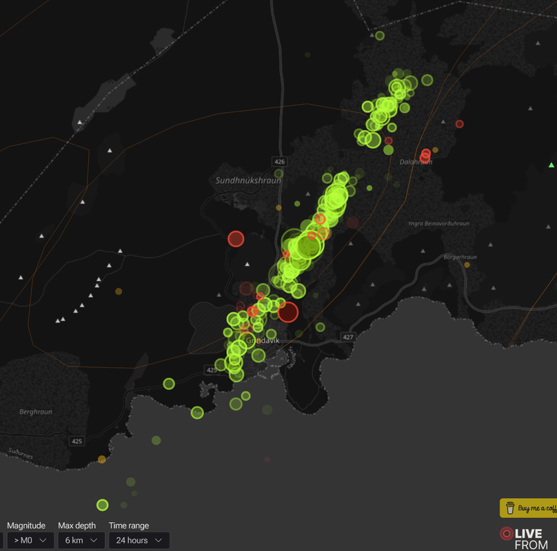
So nice to have that data visualized in realtime.
I place my bet on that rather empty spot just between Grindavik and Hagafell. Basically right next to the green house, I’m afraid.
That was my original thinking, but perhaps a little further north.
I’m now looking at north side of Hagafell. There’s a lot of hard stuff above the dike, so it’s spreading out along paths of lesser resistance.
Either that, or there’s not enough pressure to break for the surface. That would be a better short-term solution – until a future big “cough” from way down anyway!
Does anyone have old visualization of quakes of the past 3 eruptions in Iceland? Mostly interested in what happened the 24 hours before eruption started.
Can the stupid volcano erupt already? This is getting tiresome.
you know what they say “a watched volcano never erupts” – we just have to pretend not to be watching for the next few days and then maybe it will surprise us
LOLOLOL! He get shy…
I seem to remember that comment about previous eruptions in Iceland.
Is there any new information about CCN available anywhere?
CCN is producing a hydrothermal-source swarm along with some moderate volcanic seismic activity. There has never been a hydrothermal swarm for the past 10 years of constant seismic activity. The IGEPN has stopped making reports on the volcano and is either having big problems with their seismograms or refuse to release data so all of this information comes from the SGC
On the one hand I also feel the torture of waiting for something, on the other hand I know that any eruption will be the End of the World for an innocent and beautiful Icelandic town.
can imagine at this stage they just want to know what is going to happen, the town looks badly damaged whatever and suspect some may decide to move elsewhere and settle down there
The state of uncertainety must be nerve-racking for the people of Grindavik. What happens? What’s going to happen? Will our house survive? When can we come back? How much damage? How long do we have to stay at exile places? …
Today there is a misterious line of earthquakes from the Ocean far offshore (50-60km NW of Geirfugladrangur) in the far west to Hekla in the far east. Is this caused anyhow by Grindavik’s intrusion of is it a completely different development on Iceland’s rift systems?
I see what you mean when you look at the whole island IMO earthquake map. To me it’s like we can see the MAR opening up across south west Iceland and little snaps happening all along it. And it would make sense that tension release or change in pressure from the magma beneath propagates along that direction because it is where the MAR goes.
But most likely it’s coincidence, we humans do love to see patterns everywhere.
On some occasions in the past I noticed that there happened earthquakes both on the Reykjanes peinisula, the Tjörnes fracture zone (northern end of Iceland) and on a curving line following the VZs between them. There appear times of “makro” movements when earthquakes appear on a long line, and other times of “mikro” movements when earthquakes stay in a localized region.
Sometimes – like now – the line of earthquakes stops at Hekla or Katla (Myrdalsfjökull).
50 years ago Heimaey in a video clip Werner Herzog’s movie that used sources of the Kraffts: https://www.youtube.com/watch?v=ADlAVGCwLSM
Without the Unzen disasters they could enjoy the present development at Grindavik and show how professional volcano enternainment combined with scientific knowledge is done! Certainly they would also enjoy reading Volcanocafé 😉
11.15 big one on the DAS feed
11:14:48 timestamp
Sorry typo 11:14:58
Your time of 11:14:58 is exactly what is shown on the DAS display as I had to back up the display by almost 8 hours to take a careful look at this. What is interesting is the the officially recorded time for this quake is 11:15:02 which is 4 seconds time difference. Is the clock for the DAS display off from the UTC time centers (atomic clocks) or is the IMO time off? Obviously someone’s time is off by about 4 seconds.
Engineers notice things like this.
Is there any possibility that this will become a Holuhraun-type event, with a collapse happening from under Grindavik? (as per Bárðarbunga). That wouldn’t be nice to see, but it makes a lot of sense to the untrained eye in the context of what could be happening under the surface at the moment.
With my limited knowledge the answer is no.
Bardabunga is a volcano in its own right that is a high mountain and the magma chamber drained out along the dyke feeding the Holuhraun eruption. Grindavik is not a volcano like that. There are volcanic systems to the east and west, but the feed of magma is totally different from what I understand.
My description of the difference is that the dropping land in Grindavik is from a narrow and long slice of land being pushed apart causing a graben. Bardabunga was a large upside down cone that drained out along a crack in the side to Holuhraun causing the top of Bardabunga to drop because there was nothing keeping it up any more.
Feel free to correct me if I’m wrong with that analogy.
That’s good to hear.
Whilst I have been an “interested lurker” for a long time, I’ve not really looked at the mechanics in any great detail before now. I rather wish I had… It’s all so very interesting!
Worth stating as well that Grindavik is not a volcano at all, it’s a town that happens to sit on top of a where there is a previous fissure (Sundhnutksgigar).
That fissure has had new magma flow into it and open up as a new dyke. This is because the Mid Atlantic Rift has opened slightly at this area allowing the magma to flow into it. The magma could have come straight up from the mantle or from the Svartsegi / Reykjanes system a few miles to the west or the Krysuvik system a few miles to the east.
These two volcano systems like all on the Reykjanes peninsula do not form huge stereotypical mountain volcanos, they do big rips in the land that the lava gushes out of at first then flows for a bit, causing a line of small mini cones at the most.
That’s my very simplistic interpretation. There are plenty of old articles worth browsing through here on VC that will show plenty of pictures and explain these things. Albert, Carl, Henrik and everyone else who has written articles are really good at explaining these things.
ie, a fissure arising further north that is fed from a main chamber under Grindavik, leading to a collapse event in that area
The systems on RVZ (Reykjanes volcanic zone = on whole peninsula) are too weak to build a central volcano like Grimsvötn, Bardarbunga, Katla or even Eyyjafjallajökull. They erupt fissures (Curtain of Fires) where they like to. Fagradalsfjall maybe also is able to do a shield volcano, but that’s uncertain.
Krafla did Grabens like Thorbjörn currently does. These graben of 1975-1984 still exist. It looks that they are after all permanent, not temporary. But it’s possible that during the Fires period of Reykjanes/Svartsengi/Thorbörn there are going to happen more uplift/sinking events like in Campi Flegrei.
11:47:07 on the DAS feed – don’t worry, I’m not going to shout about every one, but this one looks odd and unlike the others. Any ideas?
I thought maybe it was a large global earthquake, but i see no appropriate candidates.. IMO lists no candidates. So i have to assume man made noise !! It has a very long wave train, whatever caused this signature …
Thank you!
lots of ground roll at a distance to the source (5000+ meters from origin of array)
looks like we are getting a reflection off something at about 4500 meters down the array
IMO is NOW listing a magnitude 1.1 close to the array at 11:47:09
No, the dike that had just formed came from magma that had been intruding as sills in the area where the power plant is. If there was anywhere that would collapse it is there, but the sills are not merged into a magma chamber like is at Bardarbunga.
Moreso, Holuhraun erupted at an elevation of 730 meters above sea level while the summit of Bardarbunga is at a tad over 2000, and the floor of the caldera is probbaly still over 1700. So basically Holuhraun was more than 1 km below Bardarbunga at least. Kilauea in 2018 had comparable numbers, Ahu’aila’au (fissure 8) is at 220 meters elevation while the lava lake in Halemaumau the day before the eruption in Puna started was at about 1150 meters elevation, so 930 meters difference.
The Blue Lagoon and Svartsengi power station is 40 meters above sea level, and the highest part along the potential fissure line is only a bit over 100 meters, and that spot is actually where the quakes seem to be clustering and where an eruption is most likely in the near term. So the eruption is probably going to take place on land that is actually higher up than the land directly above the magma source, even if only by 50 meters.
So basically no Grindavik is definitely not going to end up in a caldera.
But if rifting keeps going it is going to subside enough that flooding may become a problem, and the risk of an eruption happening is near certain somewhere on the rift if it remains active long enough to subside that much. So there are still many risks but ending up in a caldera isnt one of them at least.
This was a reply to Crystal Palace about Grindavik ending up in a caldera
I just realized there is a GPS + Seismometer near the northern end of the Dike:
It’s name is “Litla-Skogfell”. The uplift there is an impressive +25 cm:

For whatever reason the yearly plot shows more datapoints, indicating this was a very, very recent uplift:

Grindavik has dropped over 120 cm:

Thorbjörn dropped by 90 cm:

What is that telling us, if anything?
I’m tempted to think that magma has been pushed northwards due to the “sinkhole” (sigdalur). But not because that’s where it wants to come out but instead to make room for the ground that’s sinking in. So that pressure from up north in the dike, and the pressure building up in the sill in the Svartsengi region, with all the cracking in the sickle valley leads to a likely eruption in the sickle valley unless pressure release is somehow, for whatever reason, happening quickly, suddenly at the northern part of the dike.
This isn’t particularly a ‘new’ development, just thinking I better understand now why that assessment of the likely eruption near Hagafell does not necessarily conflict with contradicting opinions that expect an eruption further north or near Eldvörp.
Oh, the things you do when you’re left waiting … 😀
https://twitter.com/volcaholic1/status/1725853627774869832
Closeup of Semeru from this morning
Luis, good one! I liked the background nature sounds too,relaxing! David
Quakes since Thursday midnight (with smalles depth downwards). There seems to be a kind of lower threshold for most quakes?
(Save the gif and watch it with an image viewer to get an infinite loop)
IMO is saying that magma is very close to the surface [like Geldingadalir]
https://www.ruv.is/english/2023-11-10-liveblog-reykjanes-peninsula-and-grindavik-396249 [update at 13:15]
They say west of Hagafell, the place on my map earlier is more north of Hagafell, seems this area is the place to watch.
So no eruptions inside Grindavik. It might be hard to see any lava on the live though, unless it has tall lava fountains.
The first part of a walkthrough of the seismicity for the upcoming eruption at Grindavik.
https://www.volcanocafe.org/grindavik-visualised-part-i/
COSMO-SkyMed wave interpolation images, published on IMO’s website 8 minutes ago. Show the deformation of the surface of the Reykjanes from 11 – 18 Nov
https://twitter.com/Icevolcanx/status/1725872880657809644
Sometimes on top of the data it would be nice if they’d also made an indicative statement as to what that means, something like “easy peasy” or “RUUUN!!!”
Just to put it in perspective. 🙂
Luis, I am looking at the GPS data from stations to the east, such as STAN, FEFC and KAST, and I don’t see a -50 to -60 mm drop on the east side. These stations show slight rise or stationary on elevation changes, but no -50 mm change is evident from Nov 11 – Nov 18 (at least to me) I believe we would want to coorelate the inSAR readings with the GPS readings. I hope I am not missing something here??
The map does not show ‘up’ but ‘movement towards the satellite’ which in this case is from the south. It combines elevation and horizontal movement. These images can be misleading if not realizing this.
Starship second launch was just done, the improvement in less than a year is nothing short of insane.
You mean it didn’t blow up?
Yes it blow up!
Something something Kessler syndrome,
Flight termination, so yes it blew up, but the launch was complete with no engine failures and successful stage separation. If it was a non-SpaceX rocket the getting to space part would be a total success but SpaceX lands their boosters, which didnt go to plan, though im sure you remember how many Falcon 9s blew up trying to land and look where that is now.
The actual ship was also terminated at altitude. There is no risk of kessler syndrome as the trajectory was never planned to actually be orbital, only to reach orbital velocity, so the reentry can also be tested. I expect the termination at altitude may have been a mistake as it seemed unplanned, a few people at SpaceX might not be getting a cybertruck for christmas…
But remember historically all of this development was a closely guarded secret and the public usually only ever saw the polished result, which often still failed the first time. Getting to space with the second launch attempt is a crazy achievement. Starbase, as it is called, was literally a sandy dune field only 6 years ago, it took Boeing about 6 years to decide what colour of foam to put on the SLS… maybe not exactly, but the pace of development at SpaceX is like the space race of tbe 60s but with decades off accunulated advances on top. Tesla started as a crazy idea in 2006, and now sells the most popular car of 2023, sometimes a new player in an old field is what is needed to get things done.
Having over 30 raptor engines working togther is also pretty rad, they seems to overcome the technical instabillty problems that the russian N1 rocket had with its booster engine complex that led to its destruction many times.
Im russian born adopted from so knows a thing or two about the old sovjet space programme and current rockes and russian rocket engines are fabulous in performance and efficency, but Space X is probaly going to exceed them with their raptor – merlin engines
But Im not a expert like you
https://twitter.com/JudithGeology/status/1725875028565110807
Today, I am reading Caracciolo et al. (2023): https://doi.org/10.1016/j.epsl.2023.118378
In the “Reykjanes Peninsula … there have been three 400-500 years long eruptive cycles in the last 4000 years at time intervals of about 800 years.”
The last cycle is illustrated in their Fig 1 and their Figure 9, which illustrates what the “magma plumbing” might have looked like during the eruptions in 800-1240 CE.
Luis, I took a short bit of time reading the drill log of the SV26 borehole data. It seems like Iceland is just one volcanic eruption after another. What fascinated me, is to see weathering of some of the layers into clay, but also pillow lavas which are those erupted underwater. After all this consideration I began to wonder.. once these layers were on the surface, but are the newer layers pushing the land down underneath? The well drill was 2537 meters deep, which is well below sea level. I am wondering if any land subsidence takes place in Iceland? and if so, how much?
Yes, outside the inflation periods Reykjanes is sinking. It’s heavy oceanic crust after all. Very simplified, continental crust is light and floats on top of the mantle, creating dry land. Oceanic crust is dense and make basins that are filled with water. Iceland is more or less oceanic crust held afloat by the hotspot upwelling.
Hello!
Seems the volcanic eruption started in the HydroPlant (Im not sure)
Look at MBL.IS
https://youtube.com/clip/UgkxLqgJgD7u1GFDn0bOBNO4zXBxcVjNjDRA?si=mnB9TB_7xePncFaW
It looks like black smoke coming out of the plant…
Steam from normal operations, illuminated by floodlights and partly self-shaded. It is quite convincing – but no eruption. If it were, it would have bee safely contained behind the new wall. On the wrong side, but that is a detail
Thank you Albert!!
@Vedurstofan
has changed the text on its homepage ……………
https://twitter.com/DottirGongu/status/1725973790872514649
Not surprising, this isn’t another Fagradalsfjall eruption, Different location, and somewhat different magma system. It took a while before we got the eruption in 2021 so it might take a while before we actually get in a eruption.
Yes… sooner or later i think…
So exciting to see those live … 🙂
That was 3 minutes ago.