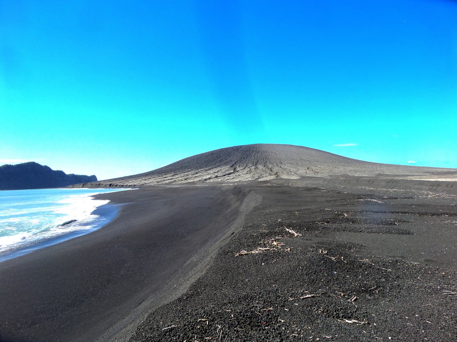
The cone and ridge before the destruction
As more information comes in, it is time for a brief update, and for a theory on why the eruption of Hunga Tonga was so destructive for what was, after all, a fairly small volcano.
The death toll of the tsunami at the moment stands at five, three at Tonga and two in Peru. There is extensive damage along the western shores of the Tonga archipelago. Damage at the capital is limited, but other islands have not yet been contacted, and it appears that they have been affected much worse than initial reports suggested.
There is damage further away, boats in harbours in New Zealand and Japan, and some minor coastal damage in the US. There is an oil spill in Peru, from a tanker that was pumping out oil as the tsunami rolled in. The coast is polluted over 1 or 2 kilometers. But these pale into insignificance compared to the local damage.
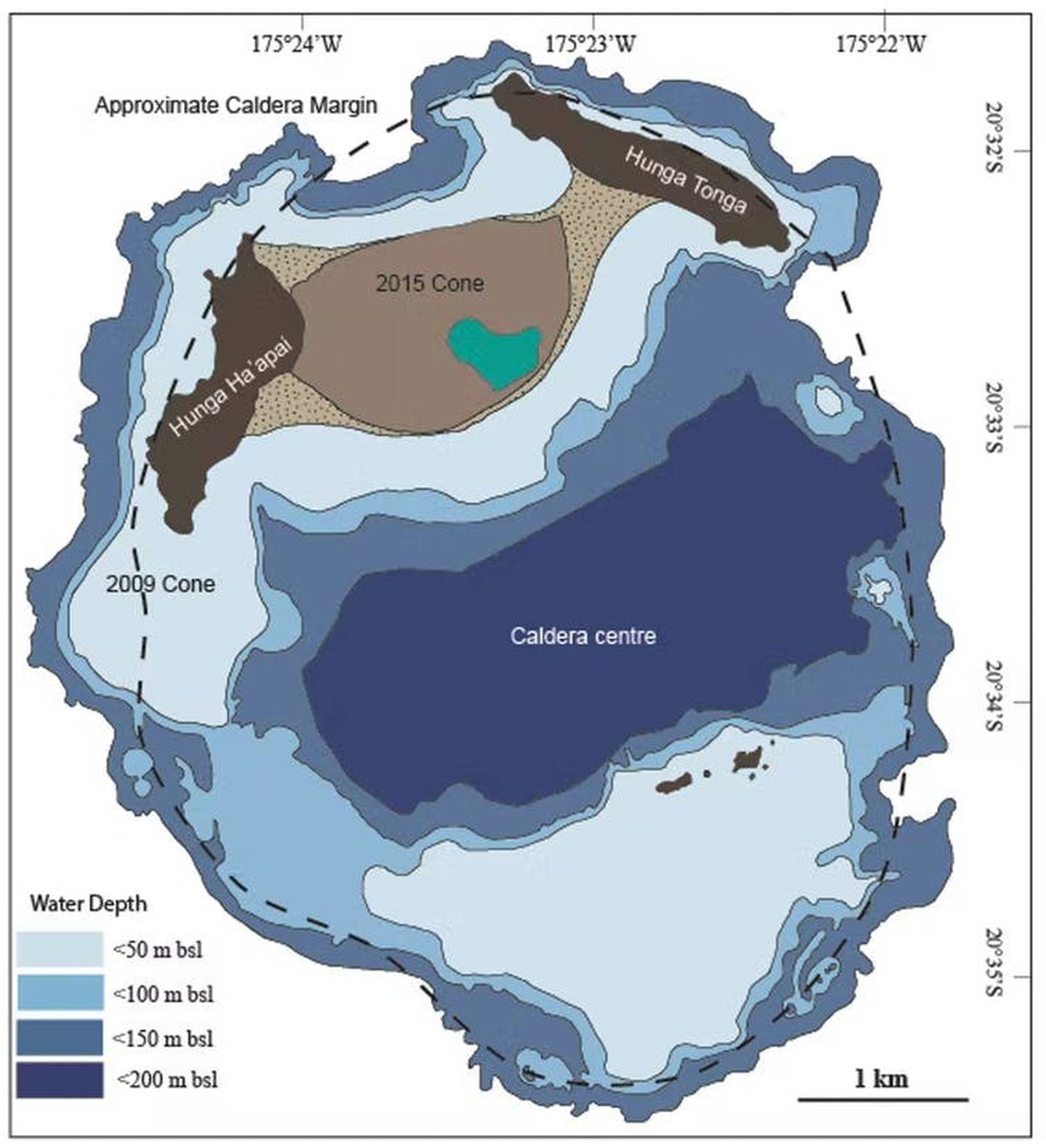
Hunga Tonga has been reduced to two small slivers of land, as shown above. (Officially it is called Hunga Ha’apai, and Hunga Tonga is the eastern ridge, but this distinction has quickly been lost.) It is interesting that these are the highest ridges of the old caldera rim. The lower lying land, perhaps some tens of meters above sea, is all gone. That includes two small islands that existed 3 kilometers to the south, on the southern caldera rim. The destruction suggests that it was caused by more than the explosion (which would have gone for the steep, high ridges) . The tsunami may have contributed to the lost land, especially if it was much higher than we assumed.

Sentinel 2, Jan 17 2022

This is from the same Sentinel image as above, but using different filters. It covers a larger area of about 20 km across. The bright spot right of the centre is the remnant of Hunga Tonga. The linear stripes are floating debris.

Photos suggest something like 1-2 cm of ash on Tonga, 60 km from the epicentre of the blast. That information is not enough information to calculate the total volume of ash! For that you need to know thickness at several distances from the eruption. But we can do a comparison. Hekla in 1108 AD covered about 10,000 km2 within the 2-cm isopach (contour of ash thickness). Note that that was with a strong southerly wind: the ash was almost entirely to the north, with 2 cm thickness out to 150 km away but only in a narrow cone. Assuming equal distribution in all directions, the 2-cm isopach of Hunga Tonga would be similar in area. Hekla ejected 2.5 km3 of tephra. We are in VEI-5 territory, but with very large uncertainty!
Comparing to to Ilopongo 540 AD, where the same isopach covers an area of around 150,000 km2 shows that we are very definitely not talking VEI-7! Taking that eruption (107 km3 tephra including ignimbrite) and scaling it to our area gives 8 km3 for Hunga Tonga. Those two numbers, 2.5 and 8km3 give us a ballpark, but no more than that. We don’t know enough yet.
A report from Tonga itself speaks of 10 cm of ash. That would push the numbers up to over 10 km3 of ash. However, I expect this refers to maximum thickness (wind blown) rather than average.
There have been claims that this eruption was ash-poor for its size. Before we make that conclusion, we need to know much more about the amount of ash. These estimations point at a VEI-5 tephra class, but it is based on a number guessed from one long range photo!
The tsunami was far worse than first reports suggested. The early videos and stories showing a dangerous but manageable wave appear to have come from sheltered areas. The capital was not exposed to the largest waves. But elsewhere on the archipelago, waves of 5-10 meters high have now reported. A few small islands were wiped off the map. This explains the size of the long-range tsunami, with 0.5-1 meter commonly across the Pacific. The height of a tsunami depends a lot on the shallowing sea near the coast, and on bay resonances. A 10-meter wave at Tonga would be down to 10 cm at the distance of Alaska (this includes a correction for the curvature of the Earth – people adamant that the Earth is flat will see a smaller tsunami). That is indeed roughly what was reported.
The scary thing is that a VEI-5 managed a Pacific-wide tsunami. Imagine what a large VEI-6 could do in similar circumstances!
Let’s discuss three aspects: the explosion, the tsunami and the air pressure wave. After I will talk about the destruction of the islands of Hunga Tonga before the bottom line: how did this happen, and can it happen again?
Boom
This was an underwater explosion. This is clear from the fact that the area above sea level around the centre of activity had already been removed b the explosion of Jan 14, itself possibly VEI 4. The sea had covered this area.

Planet, Jan 14, after the initial explosion but before the main event. The centre of activity is now under water
There are of course examples of underwater explosions. We even had made some ourselves. Here is one we made earlier: the Hardtack Umbrella event, in hindsight a stupendously stupid polluting idea to use nuclear weapons in the sea. It was an 8 kton explosion. detonated 50 meters below water. On the video, note the wave engulfing the ship.
The wave is caused by displacement of water. The big explosion vaporises the water around it. This expands by a lot (roughly taking up 1000 times its original volume). If a globe of 100 meter radius evaporates, it creates a bubble of 1 kilometer in radius. (The Hardtack explosion did not reach anywhere near this size.) The bubble expands supersonically – faster than the speed of sound in water (1500 m/s). The water can’t get out of the way that fast, and a shock wave forms. The bubble continues to expand but it overshoots. Once it gets too large, the pressure in the bubble is now lower than that in water, and the bubble begins to collapse. You will get a pulsating behaviour where the bubble expands, collapses, expands, etc, all within a fraction of a second. There are many youtube videos showing this effect. Each collapse causes an overpressure of water at the central point, and this causes a jet of water suddenly spraying up, as seen in the video above. And if the explosion is at the bottom of the sea, this jet can also bring up debris from the sea floor.
The description above is for explosions where the bubble is smaller than the depth underwater. This is also the case for those youtube videos on experiments of underwater explosion (if only for reasons of safety!). In the case of Hunga Tonga, this wasn’t true. The bubble became larger than the depth, and exploded into the air on its first expansion, with a speed far exceeding the sound speed in air. This caused the huge bang heard as far as Alaska (though regrettably not by our local correspondent motsfo): it was a sonic boom amplified by the fact that the speed of sound in water is so much higher than that in air.
On reaching the freedom of the atmosphere, the overpressure in the bubble dropped instantly and water saw a chance. It pushed back into the hole, with the water flowing in from all directions and colliding in the centre at the speed of sound. This violent collision threw a big jet of water kilometers into the air. It also caused the water bulge which started the tsunami. The bulge, tens of meters high, began to travel outward.
Tsunami
The speed of a tsunami depends on the depth of the water: it goes as the square root of the depth. The wave took around 10 hours to arrive at Alaska. That gives a speed of 250 m/s. This speed is reached for an average depth of roughly 6 km. This is indeed the depth of much of the Pacific.
The wave travels at this enormous speed through the ocean, but at very small amplitude, only a few centimeters in height. A wave a few hundred kilometers long and a few centimeter high is difficult to detect! But when the wave approaches the coast, things change. It slows down by a lot. When the sea becomes 100 meter deep, the speed is down by a factor of 7. The wave from behind is still traveling at the old speed. The water now piles up. This piling up causes the tsunami.

The same effect occurred at Hunga Tonga itself, but in reverse. Initially the wave was slow, as the water around Hunga Tonga is not deep. It accelerated as it reached deeper water. The other Tonga islands are sitting on a separate underwater ridge, so here the wave slowed down again and the wave height build up. The height it reached would have depended very much on local conditions, the presence of a reef, etc. But the wave would have come suddenly. As it began as a water bulge, there was no initial withdrawal of the water. There was no real warning.
There has been discussion whether the long distance tsunami really was a water wave. The alternative would be a meteo-tsunami, formed by the air pressure wave. The timing settles this question: the arrival in Alaska agreed with speed of the ocean wave, whilst the air pressure wave had arrived saveral hours earlier. The tsunami around the Pacific really did come from this single-point failure, the Hunaa Tonga eruption. It will have been amplified by local conditions, such as the shape of a bay, but it originated from the sea.
But what about the reports of waves in the Atlantic? That is rather far away, and America forms a bit of an obstacle: it takes a big wave to cross that! In the Caribbean, waves of some tens of centimeters were reported. That could be within range of what can be caused by the air pressure wave. And it is not unique: after Karakatau 1883, the tsunami reached far and wide with an arrival time consistent with the known depth of the oceans. But in the Caribbean it arrived much too early. It was unexplained at the time, and a different cause was suggested, perhaps some local event such as an earthquake. Perhaps this too was the air pressure, a meteotsunami. Meteotsunamis are often caused by wind, but that can be excluded here.
Air wave
The explosion was heard far and wide. It arrived at Tonga still as a sonic boom, and it was deafening. That would have been within minutes of the explosion, perhaps five minutes before any ocean waves arrived.
It is an interesting fact that closer to the eruption, nothing may have been heard. The sound wave was emitted in all directions. But the speed of sound is larger at sea level than at higher altitudes. It depends on temperature (not pressure): the sound speed is higher in warmer air. As you go up in the atmosphere, the temperature drops and sound slows down.
Imagine carrying a very big vertical stick (representing the crest of one wave of the sound where the sound is moving horizontally; it may be easier to visualize as water wave on its side). If the top moves slower than the bottom, then the stick will not remain vertical but will start to bend back. The sound wave travels at a right angle to the stick, so now it begins to travel away from the ground. Indeed, when St Helens blew, people tens of kilometers away (where they should not have been) heard nothing. As far as sound was concerned, it was a deadly quiet zone. The same is true for lightning storms. You hear the thunder for nearby storms, but not for ones you see on the horizon. You are in their silent shadow zone.

Sound carries further if the air at ground (or sea) level is colder than air higher up. In that case the wave hugs the ground and can be heard farther away. You really do hear better in winter!

Once the sound wave travels upward and away from the ground, it eventually reaches the tropopause. But here the opposite happens. The temperature, and thus the sound speed, now increase with altitude. The temperature is lowest at the tropopause, and it gets warmer again higher up. So the sound wave does not enter the stratosphere but it reflects back to the surface.
This reflection can happen close to the ground if there is a temperature inversion. This is called troposphere ducting and it allows (sometimes) thunderstorms to be heard to hundreds of kilometers distance. That is not enough for us. By ducting the sound at the tropopause, if it is loud enough it can carry many thousands of kilometers. In the right conditions it bends back to earth, to startle the unsuspected listener with the sounds of a distant battle. In the past, it was often compared to cannon fire. Of course that is not something we are too familiar with nowadays!
The people on Tonga startled by the bang, heard something that may have come back from the stratosphere. So did people on Fiji, in Australia, New Zealand and even Alaska. Hunga Tonga, I think, now holds the record for the most distant sound heard by ear by people. Someone in Alaska is the world record holder!
The audible sound was accompanied by a pressure wave, a rise and fall in air pressure, This wave was measured all around the earth. In Manchester it arrived at 7pm UT, some 15 hours after the eruption, and lasted 20 minutes. A quick computation shows that it traveled at roughly 350 m/s, i.e. at the speed of sound. Krakatoa had done the same, and its pressure wave was measured all over the world.
There was a second pass of the wave in Manchester at 2am. This was the wave that had traveled the other way around the world.
The next day, the wave re-appeared at 7am, followed by its counter-rotating counterpart at 2pm. By this time it had gone around the world 1.5 times. After Krakatoa 1883, in some places the pressure wave was detected 7 times. Imagine a sound so loud that it was heard worldwide for five days! (Of course we can’t hear these pressure waves.) We are not there yet with Hunga Tonga but who knows.
The figure shows the Manchester wave of Jan 17 with bumps at 7am and 2pm. There are better detections available – but it is nice to see one next door.

The Manchester wave carried an excess pressure of 1.5 mbar. This was similar to what was reported at various places after Krakatoa. The sound wave appears to carry a similar amount of energy to the sound wave of Krakatoa, even though that was a significantly larger eruption. I believe this is due to this eruption being a little below the water surface. This amplified the pressure wave in a way similar to tsunamis: as the pressure wave entered the air and slowed down, it piled up and this increases the amplitude. This was (and perhaps still is?) a pressure tsunami.
Destruction of Hunga Tonga
Explosions under water create a far more destructive pressure wave than one in air.
This wave expands out into the water. The water is incompressible and just passes the wave on. When it reaches something solid, it becomes hugely damaging, as the wave has the weight of water behind it. A torpedo acts this way: the shock wave in water punctures the hull of a ship. (It also does considerable more damage as the wave passes through the structure of the ship, much more so than an explosion in air would.)
https://www.navygeneralboard.com/how-do-torpedoes-damage-a-ship/
Such a pressure wave was set by the original explosion at Hunga Tonga. But this was within a confined space. The old caldera wall, 3 kilometer wide, is still there. This shock wave would have bounced off the shallow bottom and the steep wall and reflected back towards the centre. Perhaps this is the cause of the wide destruction of Hunga Tonga. The two small island on the southern rim are gone, even though they were some distance from the explosion. I imagine that this supersonic shock wave shook the old crater rim to pieces below sea level. This acted together with a water wave perhaps as high as 50 meters and the explosion above the water. Only the toughest parts of the caldera ring, protected below water by a shelf and above water by its height, survived.
The power of water
That leaves the question how this eruption happened. Why was it so large and so loud?
We are talking about water getting in contact with magma, as driving the explosion. It has been presented here as a collapse of the roof of a magma chamber, water rushing in and instantly flashing to vapour. That picture has the basics but it is too simple.
When water is brought in touch with lava, there are explosions. But there isn’t one big explosion. For instance, when lava entered the Kilaueau lake (remember that one?), the lake boiled away but it did not cause a big explosion. That is because of insulation. The water touching the lava becomes vapour. It now forms a layer between the water and the lava, and this layer insulates the water. The rest of the water does not boil until the vapour has moved out of the way and the process begins again. Lava itself also insulates well, and once the surface has lost heat to the water, it takes time to heat up again. This is not the way to get a big explosion.
What you need is to confine the water, so nothing can escape. You also need to put it under pressure, and give it time to heat up. The pressure raises the boiling temperature so now the water can be superheated. But don’t put it under too much pressure, as it can no longer boil (see the post on black smokers).
How is this done? For Hunga Tonga, the process started with the Jan 14 eruption. It destroyed the central part of the island to below sea level, and left the conduit open and under water. Water flowed in, but did not do too much except make a big steam cloud, for reasons explained above. Now the conduit collapsed. Suddenly the water was caught between a rock and a hot place, and under considerable pressure from the mountain above. I imagine this happened a few hundred meters below sea level, but no more than 500 meters because the rock would have carried too much weight for the water to boil. The water could not escape, and it began to heat up. Eventually some water boiled and vaporized. The expansion as it vaporized increased the pressure: remember that water is not compressible, and does not respond well to being pushed. The extra pressure broke the blockage. This dropped the pressure, and therefore the boiling temperature came down. All of the liquid water suddenly found itself above the boiling temperature, flashed into vapour (cooling down quite a bit in the process) and suddenly the conduit was 1000 times too small for its contents. And up it went.
The same process could happen on the flank as well: the flank breaks open, water goes in, flank slides down which closes the hole, and it is time to get yourself to a safe distance. It is now a ticking grenade.
This model explains why Hunga Tonga’s destruction happened a day after an earlier large eruption which took the cone top below sea level. It explains why Krakatoa’s huge boom came after three or four big booms over the previous day. These kind of events require priming. And finally, it explains why Krakatoa’s magma chamber survived. (We know that it did because Anak Krakatau formed in the same location.) The roof of its magma chamber was fine: all the action was in the conduit. It predicts that while the initial explosion happened under water, it immediately reached the surface: the vapour bubble grew larger than the depth of the explosion which was only 100 to 500 meters below the sea.
This model it makes it less likely that another such explosion will happen soon. Grenades don’t go off twice. It is possible there is a second grenade there waiting to be primed. For now, however, we should look very carefully at similar locations elsewhere around the world. We know similar sea level volcanic islands, and have discussed them here at VC. We will be much more cautious about them in the future. This kind of explosion is not common. It may not happen every century. But once burned, twice shy.
This won’t be the end of Hunga Tonga. One day the island will reform, and the cycle begins again. But that will take time. In the mean time, few people will ever be able to say to have been on this island. That also is similar to Krakatau: if we had know it would cease to exist, they would have documented it better. We know remarkably little about it. You may want to look at the story below, perhaps the best remaining photographic record of this phase of Hunga Tonga. I think the person is too old to qualify for a Darwin award, but what a story to tell, walking on the biggest bomb on earth. Almost nothing in the photos and video still exists.
Albert Zijlstra, Jan 2022


Before reading (will follow):
There’s always a bigger fish (28km at base), top 65 m under surface:
https://earth-planets-space.springeropen.com/articles/10.5047/eps.2013.01.002
https://earth-planets-space.springeropen.com/articles/10.5047/eps.2013.01.002/figures/7
Thanks for the article!
I am not sure I agree with the “this was a VEI5, imagine what a VEI6 would be capable of”. First, as you state, we simply do not yet know the VEI here. Second, more important, this eruptions is “VEI-punished” for being short and clean. To make a big shock, bei it water or air, one needs a sudden change. As has been calculated here, to drive the pressure wave alone about 50 to 60MT TNT equivalent seem to be needed. In total energy, it is not at all clear if this event is smaller than several VEI 6 that happened to use “their” energy budget for excavating more material over hours/days instead of instantaneous release.
Second, the pressure wave to me seems actually at least as powerful as the Krakatoa one. Then, in Tokyo 1.45mbar were reported, but looking at that plots, it seems this is already “peak to valley”. That does not really compare favourably to your ~1.5mbar at a whopping 16000km distance. Thus also the observations that the Krakatoa pressure wave required “only” 33MT TNT equivalent to initiate.
Bottom line, I am not at all sure (again!) that the VEI scale meaningfully describes such a short violent “clean” blast. Let us not forget that the umbrella cloud of the explosion is absolutely enormeous, even by hydrogen bomb standards…
Yes, that is a good point. But I think the case remains that this is unlikely to be the worst that this kins of volcano can do. The air pressure wave is very impressive and may well be the biggest for several centuries. The tsunami though collects its energy over a bit longer time and does not need an instant bang. The tsunami could have been even worse.
Yes, agree of course! I just mean that whatever the final verdict on the VEI as measured by tephra volume is, what we have seen is an unusually violent event. To be honest I still listen to the videos of the atmospheric shock recorded in Fiji with some scientific disbelief. No rumble, not even like a thunderbolt from lightning. Basically just an instantaneous “bang”. It sounds like the sound files from atmospheric nuclear tests at much shorter range. I struggle to understand the process behind this sudden release. The caldera itself is ~ten seconds big in sound travel time…
Do you have a link to a true unbelieveable video?
I watched some, and I found it “okeyish”, maybe I forgot about the large distance^^
The only one with a real sharp detonation crack was from up close, some tens of km maybe..?
I mean this one here:
https://www.youtube.com/watch?v=SNRAfS_xhhw
at about 3 seconds. A sharp bang. At presumably 700km distance! There are videos where the sound is much louder, I think they are from much closer, but still many tens of kms away.
In a community I’m member of, I found that video link: https://twitter.com/portiajessene/status/1482331548330659841
I don’t know which one is original, or what is the true source in the first place.
But if that is really Fiji, and it is really the volcanic sonic boom, and not some 2022 clickbait fake gun sound, then it is more than slightly massive.
700 km and still that sharp … seriously daheq was going on??
Wonder what Krakatoa sounded like 😮
And of course thank you very much, 2 sources of the same video is better than one, and I might not have gone back to the first post in the community’s thread without you posting a video more impressive than all before from the explosion 🙂
Microwave, I think that is identical to the video I linked! Yes. Exactly what I mean.
Always the chance that there are fakes. But it matches with the videos from closer by (Tonga??) where the bang is truly massive, and also exceedingly sharp, although also that must be tens of kilometers at the very least.
Dominik,
admittedly though, what is a bit fishy in the video that is ostensibly from Fiji is the fact that it is not at all clear why the person is actually filming. Why would they expect a shock to arrive in that very moment, and they were not filming anything else. People have used random videos to create fakes in this way before…
And since it has been re-posted and re-posted a dozen times, probably, any accompagning info presumably is lost…
So it is believeable that this video is about this volcanic detonation.
There are minor boring “cracks”, and then that extremely loud sharp crack.
And in the video below from Dominik there is *also* the boring cracks and than the sharp aggressive crack.
So looks possible to me.
Now one could remove the original soundtrack from a video about Fiji (so everyone can be shown it is really filmed on Fiji…), and overlay it with the sharp crack filmed on Tonga. Then tell everyone that even in 700 km it had sounded so aggressive.
Such a fake would be feasible, in theory.
Or it wasn’t even filmed on Fiji. I don’t know what it really would look like, filmed from Fiji.
So if none of these 3 fake possibilities is true then the video might be the truth.
But Groundhog made a fair point, something I didn’t even think about, when saying that the video was very coincidentally filmed.
Yes, in truth you would have to have filmed with some infinite buffer system, where you could film some 30, 40 minutes and immediately after hearing the crack for yourself stopping the video, thus only keeping the last 15 s or the likes.
Or it was pure coincidence the video author was filming right at that very moment.
Could we also tie it to the lighting? Sun was just about to set when the detonation took place, IIRC??
There gotta be some way to prove or reject that video for good 🙂
Groundhog: that may just be bias. People film all day long. Before the big blast, there were several smaller ones. Maybe the thousands of vids without the big boom just get no popularity…?
Probably Tonga??
Remember that the shock raises the air temperature behind it, at least close to the explosion. The sound speed in the heated air behind is quite a bit faster. So the sound wave from a bit further away which follows will catch up with the front wave, and they arrive as one sharp bang.
It may be I am biased. I was immediately thinking about light crossing time arguments. There will be effects that counter dispersion, surely. But there will also be the contrary. I mean, we hear the sharp bang. All I am saying is I am puzzled. Even at 70km, and much more at 700km.
Suppose the model you present above is correct. Probably we are then talking a sizeable fraction of a cubic km of water, no? If that is supposed to release the 60++MT energy equivalent we seem to need, there must be catastrophic failure of the “lid” over square kilometers. A kilometer is of course already 3 seconds in sound travel time.
I am not saying I have a better idea of course. I am just amazed by such a large object releasing such a sharp shock.
Dominik,
your concern is understandable, but you need to keep in mind that the initial expansion is supersonic, and a shock wave forms. As the shock wave expands, the expansion speed becomes subsonic at some point, and later also the focusing nonlinearity (due to the effect that Albert mentions) decreases, but the original, seconds-long source effect has still been compressed to a very short wave front (followed by longer noises, like an aircraft supersonic boom), and will continue to propagate like this for a while as a sharp “bang” or “crack” sound, until dispersion “dilutes” the wave packet, making it evolve into a longer “rumble” sound.
Groundhog, I see the point. I have no direct data to compare. What I have seen recordings of are such sharp “cracks” from very small scale explosions during more Strombolian eruptions (e.g. happened a few times at La Palma last year).
But even very energetic eruptions seem only rarely be so sharp. E.g. no such reports I know from Pinatubo 1991.
It seems however we in a way agree that the original source was on timescales of seconds. Which is exceedingly rapid for such an amount of energy. Now thinking more closely, there is of course the famous Manastash Ridge observatory logbook from 1980, where the observer writes he “Beard a loud ‘boom’ while sleeping”. I always imagined that as more akin to a thunderbolt…
This is all the problems of the VEI-scale.
I would say that it was a VEI-5 based on the likely amount scoped out. That number may go up when we have bathymetric data in the future, but it is unlikely to go down.
On an energy release side of the equation it was definitely more akin to a VEI-6, but the VEI-scale does not give shit about energy release. So, I instead used the pressure wave to calculate the yield using the formulation for nuclear tests.
I am happy with this being a VEI-5 at 55 to 60 megatons. It is as close as we get without a redefined scale.
It does though give food for pause. For one, we do not know yet how many ships disappeared that was closer to the island. The reason I say that is that if those ships was not warships they probably was blown apart.
In the end, I hope this does not happen in a larger volcano near a city. It is here scary as hell to think about that most of Camping Flagrant is out in the bay of Naples.
Won’t the total energy release be larger than 50MT by quite a bit? I have not seen your calculation of course, but the volume of water vapour you expand would require about that number already it seems.
This would also match well with Yokoyama 1981 / Krakatoa:
“In this paper, the above method will be applied to the barogram at Tokyo which recorded a pressure disturbance of 1.45 mbar from the Krakatau erup- tion as shown in Fig.9. Tokyo is about 5863 km distance from the origin. The average volume introduced into the air is 260 km3. Taking 1 cal of ex- plosive energy as giving an expansion of 8 cm3in the atmosphere, it may be concluded that the Krakatau explosion had an energy of 1.4 × 1024 erg.”
1.4 yotta-ergs are “only” 33MT TNT.
The rest of the energy budget is as always probably hard to assess. But as said above, another lower limit could actually come from the size of the mushroom cloud before it stopped free expansion. If scalings are anyhwere close to how they seem to be for nuclear airbursts, a 300km umbrella cloud requires a scary amount of energy…
This is about PDC (Pyroclastic Density Currents) in the area,
https://www.frontiersin.org/articles/10.3389/feart.2017.00072/full
Not pretty:
https://www.bgs.ac.uk/geology-projects/volcanoes/pyroclastic-density-currents/
Nice article Albert; priming the gunpowder is a neat way of explaining it. The question remains, where next?
The SO2 at Taal is back up to ~10000, if you can trust phivolcs.
Very good summary of the events and also explanation of more difficult things like tsunamis.
Thank you.
When I saw the older man in the short yt- film at the end I suddenly saw the early birds (here seagulls flying around) and flying dinosaurs survive, whereas he, the land creature, would have died, if he had been there on Jan 14th.
With this relatively small well monitored tsunami travelling around the world we now know how most of the dinosaurs died, and that’s also how they are found: Washed up together in muddy creeks back then, river valleys, all together in one place like in Hell’s Creek, North Dakota. And this was around the world and can perfectly be seen in Peru.
So, this will also tell us about 65-66 Ma. For the people there intimidating, for science of course precious.
Dinosaurs (many fossils actually) are sometimes found in ancient muddy creeks. That is however because those where conditions conducive to fossilisation. There has never been a confirmed finding of victims of the impact itself, with a possible exception of a new site in Dakota, but everything is hmhmhmhm “secret” there. Overwhelming majority of the dinosaurian fossil record is very far from the K-Pg-boundary…
Is that the site in North Dakota that was int the news two years ago? On photos, they seemed to be working quite far below the boundary. I had some doubts at the time
Tanis Site in Hell Creek haves animals that inhaled and ingested the hot tektites from Chicxulub as well as fossilzed tsunamis from the impacts earthquakes that caused lakes in the landscape To go wild
Its the Only site so far that preseves impact effects
A lot of birds were flying around, some of them may have been gulls, but if you freeze the frame what you see are terns — notice the forked tails, the black-capped heads, the sweep of the wing — possibly Bridled Terns.
To all new and recent commenters: Welcome! Please be aware that new commenters will see their first comment put in the ‘for approval’ queue (also known as the dungeon). A passing dragon will release them but this can take some time. Once a comment is released, further comments will appear instantly. We regret that the dungeon is necessary but we do attract some unwanted comments. So if you do not see your comment appear, please be patient. The demon at times puts other comments in the dungeon, for a variety of unexplained reasons. These can include suspicious links, too many links, too many comments in a short time, a typo in your login, and other things we know nothing about. The demon is quite suspicious. The same thing holds, please be patient. Sometimes a comment goes straight into the spam folder. In that case it is lost, I am afraid.
Are there any giant murder worms and pythons in the VC dungeons? I will never dare to visit these dungeons
Looks like this I guess:
Yeah, but i gave them a carcass to gnaw on yesterday.
Nice of yours.
Thanks for the link to Drachinifel Battle of Samar, that site has many interesting videos about the pacific war which, as a brit, I was totally ignorant, and he tells a good tale.
How the US survived with the type 18 I have no ides (and some daft commanders).
Ahhh 🙂 the VC dungeon is a snake pit
Do you have pythons and anacondas there ? I know that Carl haves a fascination for Pythons .. maybe he installed them in the dungeons
I hope they are reticulated pythons. Gorgeous animals, and smart by snake standards.
Thanks for this wonderful article Albert!
It explains a lot I didn’t get right.
It is a keeper (still in rock mood, the reposts earlier…).
Thanks for the interesting article, it definitely raises some questions about the suitability of the VEI scale for measuring the power of short explosive eruptions caused primarily by a steam explosion.
It makes me wonder if a similar mechanism was involved in past eruptions that appear to have been more devastating than the VEI we have from the ash records we have today. Santorini (Thera) springs to mind as potentially a similar but more powerful event.
It also raises the question about how often such events occur as they will be difficult to observe historically as most would likely be believed to be much smaller when we look back today than they actually were.
About DART (Deep-ocean Assessment and Reporting of Tsunami):
https://www.gns.cri.nz/Home/News-and-Events/Media-Releases-and-News/DART-network-proves-invaluable-in-assessing-tsunami-threat-following-the-Hunga-Tonga-Hunga-Ha-apai-eruption-18-01-2022
I am about to do a bit of a Jesper here but what if we put La Garita underwater and made it erupt similarly to its big one 28.2 mya?
I loved the “what if” comics =D
La Garita is the heftiest volcano explosion, am I rite?
As such, maybe half of the ocean full of pumice ==> some unpredictable climate change..?
How deep below water? Same as Hunga Tonga? So then, maybe water vapor/debris to the edge of space?
And a sizeable tsunami likely…
Apologies for much “maybe” etc., but I don’t know La Garita well… 🙂
To be honest, it needs to be maybe continental to form such a volcano but put it about 0.2 to 1 km deep. I am honestly don’t really care about the parameters here. 😉
That woud be alot of fun!
We also haves the gigant 150 kilometers wide Apolaki submarine Caldera outside the Philippines. Apolaki Caldera is the largest caldera on Earth. Althrough its quite old, and exactly How it erupted is unknown.
But perhaps many 10 000 km3 was ejected If it was formed through a single event. Much more investigation is needed on this volcano that soon will be subducted into the trench. It erupted a long time ago
If it was formed though a single event, then we may have a solid standing VEI 9, but that will be almost impossible to prove in souch old caldera, but its quite well preserved on the ocean floor
Never heard of that, now I know. Wikipedia also has some brief entry on it 🙂
You have some broad volcanic knowledge, you can be proud of!
Most complicated region on earth. At least for me. Check Benham Rise.
How?
Oki-Daito mantle plume
Possibly not existent any more
Similar situation to Iceland with a spreading ridge and a V-shape. Not existant any more. All assumed and in research. A lot of research. Difficult though.
Apolaki coud also be an impact crater, But its clearly volcanic in investigations and a 150 km wide impact crater woud have formed a recent extinction event If it was an impact crater.
Its an old caldera, and clearly not acossiated by any subduction zone, but maybe from earlier back – Arc rifting. Its certainly a large feature
I am honestly however not sure that a 150km caldera forming ultraplinian eruption is much milder on life than an impact. Anyhow. Should be readily distinguishable. No signs of hypervelocity induced shock in stone –> no pile falling from the sky…
When I looked up the Apolaki Caldera, it looks similar to the coronea on Venus, but smaller.
No, really. It has a ring around a nearly circular depression with a uplift at the center, pretty much typical of such a feature. It is not only too big but also pretty much too circular to be a caldera. It also lays at an oceanic plate – the exact opposite of the requirements to form a large-scale supervolcanic caldera. It could be something else but I do think it is something like that rather than some massive one-time explosive caldera.
Jesper, definitely no. Chicxulub crater/Area 25,450 km², Diameter 14 km.
We wouldn’t exist. Nobody.
Meteorites come with an incredible speed. Volcanoes collapse in place and don’t make a speedy Gonzalez through the Solar System.
The impactor for Chicxulub was 10-15km or so. The crater itself is vastly larger, about 180km. So that would indicate also a 100TT TNT scale event. With the normal side effects like mostly everyone having a bad day, and man having the last day.
But then, as said, this probably also would go for a volcano of that scale.
Then Apolaki is volcanic feature?
I do not know! I have never studied the literature for it. Just saying that there are in principle ways to find out.
Yeah 150 km it says though. And 20 km deep at least which is probably the decisive unit. Then it has traces on the rim. I bet they have looked at that caldera. And then there seem to be cones in that crater. Then rock samples say it is between 26 and 47 million years old.
Just saying: We wouldn’t exist if it had been a meteorite. No way. Not with that age.
Dominik: 12 km per second. that’s 720km per minute. And over 50.000 km per hour.
To pretty much meet the requirements, the crust must be continental ( I.e. pretty much anywhere on the continents), but it needs to be a extensional setting (to be honest, I only heard of it on one of the VolcanoCafe articles I’ve read and kinda do not have an understanding of it for the longest time). Nearly none of those features fit to my scenario. However, such a place could exist at northern part of Cook Strait in New Zealand in the future (hopefully, no one will be there by that time), because it lays near an extensional setting to the northeast, overlays continental crust and is underwater… a perfect area to answer our what if scenario.
Welcome to Tondano…
El Spooky.
Note, technically an actively erupting “Stuper Volcano”. All the surounding volcanoes are ring fault systems of it.
Nice article, explained some things I wasn’t sure about, thanks!
Anyone having a stab at how much water was evaporated?
Having read the article about Amatitlan and it’s violently extruded rhyolite domes, I can well see how they could ramp up to a VEI5/VEI6 even in a relatively minor eruption, calderatively speaking.
Not sure how different the effect would be, you’d have to account for water composition, seafloor/lakefloor depth etc. etc. but the mechanism sounds the same. Perhaps Momotombito could do something similar.
I posted the following way too late on the previous topic. I would however like an explanation if anyone has one to my post.
Repeat.
Did anyone else notice on the satellite image immediately preceding the blast that the sea in a large area around Hunga Tonga appeared discoloured, or was it just my imagination? I just wondered if it was some undersea turbulance prior to the blast.
Many thanks if anyone still has that satelite video and has an explanation at all.
Can you repost the satellite video? 🙂
Sorry I didn’t save it. 🙁
Just found a link.
https://www.space.com/tonga-underwater-volcano-stunning-eruption-from-space-video
And apologies again, I’m afraid I misread your last sentence.
Ok, if anyone has that satellite video, reposting highly appreciated =D
I heard there was a typhoon around the area but not sure if that could produce the discolouration.
I take it you don’t mean the sun that’s reflecting diffusely in the water, moving in from east to the west?
Other discolorations may have arisen from flat low clouds/random water vapor in the air just where Hunga Tonga was…
If you look at historical satellite images of the island, the sea was often this colour around it, clearly from run-off from the island. I expect that the recent discolouration is also material from the island, thrown out by the two eruptions. There is also floating debris visible around the other Tonga islands, by the way, on the images from after the main eruption. That will be the tsunami
Similar result using asteroid impact calculator of a 150m diameter dense rock object striking 150m water depth at 17km/s
Creates an up to 10m wave at 50km distance
https://impact.ese.ic.ac.uk/ImpactEarth/cgi-bin/crater.cgi?dist=50&distanceUnits=1&diam=150&diameterUnits=1&pdens=3000&pdens_select=3000&vel=17&velocityUnits=1&theta=45&tdens=1000&wdepth=150&wdepthUnits=1
Energy is 100 megatons
And is a VEI 0 *duckandcover* 😀
Very nice link, didn’t know that!
Just attempting to figure out how I would create a maximum air blast while having minimum surface impact 😀
I like air blasts, as I like everything supersonic =D
Expanding on the point made in the penultimate paragraph, what would be the criteria for saying that a particular volcano has the potential to erupt in this style (call it ultra-surtseyan?)? Maybe an inventory of such volcanoes could be made?
Iwo Jima comes to mind! Bogoslof in the north Pacific, Surtsey in the north Atlantic. Any volcano just breaking the surface of the sea could be at risk.
Could the dike under Fagradalsfjall extend just out to sea of the coast of Iceland and trap some water and have a similar explosion. It’s not far down and trying t find its way to the surface.
Maybe not as big, but the magma is close to the surface, cracks could form, trap water and collapse. Is that possible?
Nope, and even if it extended that far, and water penetrated, the dyke would be to narrow to be able to cause such a large eruption.
You need a proper magma reservoir that is shallow, with a body of water above, and that has either a permeable roof or a ringdyke.
Katla has the permeable roof, but not enough water.
Grimsvötn has a surprisingly solid roof, but a ringdyke.
Askja has both.
The rest are not an option for this.
Santorini and Campi Flegrei maybe ?
Makes sense. Not even a little burp then. I guess it’s all about volume of magma in touch with the water. Interesting must be a pretty rare, in human timelines, event then.
Preliminary inventory of volcanoes potentially at risk of “going ultra-surtseyan” (summit no deeper than 200 metres):
Ioto, Anak Krakatau, Vestmannaeyjar, Bogoslof, Sumisujima, Hunga Tonga (obviously)
Eldey, Curtis Island (prime candidate: 18m uplift in the last 200 years), Lateiki, Nishinoshima Myojinsho, Kolbeinsey Ridge, Zealandia Bank, Kuwae, Banua Wuhu Hankow Reef
Campi Flegrei del Mar di Sicilia, Home Reef, Don Joao de Castro Bank Fonuafo’ou
Ile des Cendres, Kavachi, Unnamed (#274050), Fukutoku-Oka-no-Ba, Curacoa, Macdonald Adams Seamount, Unnamed (#243091), Esmeralda Bank
Protector Seamounts (rhyolite pumic raft 1962), Unnamed (#243011), Giggenbach
Unnamed (#243010), Kita-Fukutokutai, Tjornes, Ahyi, Eastern Gemini, Kaitoku
Minami-Hiyoshi, Kurose Hole, East Diamante, Monowai, Kaikata, South Sarigan
Kick ’em Jenny, Monaco Bank, NNE of Iriomotejima (the big 1924 one)
Feel free to add more
Some of those I would never have even considered, Eldey and Tjornes in Iceland for example.
Do those 2 have “proper” magma chambers or are they more like Fagradalsfjall?
Rabaul is on a bay.
Going to also add a few that are not necesarily at sea level but have got shallow groundwater or lakes.
Fernandina, Cerro Azul, Wolf, Ecuador, Marchena and Genovesa in the Galapagos.
Kilauea, at least under certain conditions (not now).
Grimsvotn and Askja.
Masaya and Apoyeque.
Rabaul.
Taupo.
Taal.
Also possibly some exceptions to the shallow magma chamber, Newer Volcanics in southern Australia. Mostly is completely effusive but some of the maar craters there are big enough to be calderas, if not for how they formed. the power to excavate a 4 km wide hole in the ground, probably was even bigger than what we saw the other day…
Not sure if this could happen anywhere else, the lack of similar sized maars all over the place says no, but really who knows now. These exceptions aside though just look for wet volcanoes with magma chambers.
Queen Mary’s Peak perhaps? I have no idea about the internals of it, but for some weird reason always had an idea that Tristan da Cunha would go kablooie some day.
I think we are waiting your post on this! It would be brilliant
I saw a program that talked about the recent discovery of an active volcano a few dozen meters under the sea about forty kilometres from the entrance to Tokyo Bay.
The name starts with “oo———” but I can’t find my paper where I wrote it down and my research doesn’t turn up anything.
I think total edifice size counts. Big enough to have km^3 of liquid water deep enough to be supercritical, small enough that water can get into the innards early after the previous explosion. Unlike everyone else I think the water for the big bang in 2122 is already being/is emplaced in volume whilst pressure is low and fractured rock has many interstices.
Then its just slow heat to brew the pressure cooker back up to pressure.
Then repeat.
Different islands will take different times to blow, and have different yields.
You don’t need a km3 of water. 0.01km3 or even 0.001km3 would be enough. This because it expands so much
Really? For 10-50MT?
a mere million kg at 542.2kJ/kg (latent heat)
have not the time to do this but 1kg TNT packs a bigger bang than 1kg supercritical steam, no? Oh, lets havago.
4612 kJ/kg TNT so a 30MT blast requires ~250 MT supercritical steam or 0.25 km^3, Perhaps 3-6 km^3 wet rocksworth at 5-10% (could be less).
Carl was in the right ball park.
Thanks! I hadn’t gone through the thermal numbers. It is indeed just basically compressed steam. If the water is at 100 bar, then the steam will be at 10^5 bar. To get the 30MT TNT, that requires 0.1 km3 of water. About your number
Indeed, although it turns out to be less straightforward than I thought.
I have added a new post for info.
Basically every volcano either at sea level or with abundant water, plus a shallow magma chamber of any composition
In my mind’s eye I’m having trouble picturing how this can happen: “What you need is to confine the water, so nothing can escape.”
That the earlier explosion caused an underwater cavity or void is perfectly understandable, but why wouldn’t matter settling from that explosion fill that cavity? And wouldn’t that material be loose, pulverized for the most part? Seems like it would be quite porous, unsuitable to create the lid of a pressure cooker.
Maybe easier to imagine if the initial explosion was a flank eruption, followed by an underwater landslide, as you wrote.
I don’t know. Just typing. Quibble of the day. Very interesting article.
I don’t know! But you do have to confine the water somehow, and at pressure, but not in the main magma chamber which is too deep. The water can of course be in the magma (a few per cent) but that doesn’t quite seem to do the job.
As carl points out, low sulphur suggests little magma. Maybe just enough intruding into a large rubble-and-water filled void from previous eruptions to do the heating. A few dykes will do.
Ultimately the source of the explosion is the magma source
Heat
Pressure
Gas
Water(including water contained in the source magma
And what combinations these leads to such an explosion
Just to further the quibble, could we be talking something more akin to the boiler on a steam locomotive (without the safety valve)? The water in the boiler doesn’t come into contact with the fire, but the intense heat and reheating causing the pressure to build. On the locomotive the superheater is a “dry tube” that passes back through the boiler superheating the steam.
Is it possible that the effects of the paroxysms in the previous days created a sealed chamber in which the steam was superheated?
Providing convection is constrained (rubble will do) its actually in equilibrium. The sea pressure at depth is enough to stop any steam even if the water gets to several hundred C.
Eventually the temp gets to the pressure (height) where steam is produced (a minor eruption) which will be OK as long as not enough is produced to reduce the overburden pressure (gassy rock/water weighs less the non) and more starts to turn to steam until at some point the top blows off. Now there is little pressure and a big chunk goes bang. The stuff really deep is now underpressurised and it goes big bang!
Neat really, just a superjumbosized geyser with attitude.
“superjumbosized geyser with attitude”
Got it! Thanks FarmerOz
First Official report says tsunami was 15 m high. Not sure if this is actual veight or run up (dont know how high is land there)
https://mobile.twitter.com/ConsulateKoT/status/1483384039826464768
Media reports say thay NASA estimate the blast having a 10 megaton equivalence
Try the impact calculator to get 10 megatons
It is going to have quite small effects
A 60meter rock entering at 90 degrees to the surface at 17 km/s creates an atmospheric energy release of 10 megaton
So it kind of works
How big was the russian meteorite in 2013?
20 meters
So 3.times that
https://twitter.com/gbrumfiel/status/1483522047242350594
BREAKING: NASA scientists estimate Tonga blast at 10 megatons.
I have to say I am highly sceptical about the 10 megatons.
It will be getting bigger by the day, the wave higher and people who have seen UFO’s in the past will call their local paper and say Hi, I heard it too, and there was also a strange light. A report of a woman in an Alaskan paper sounds like she describes Poltergeist. Tallis won’t call. Neither Craig. It is certain people. Wondering that nobody from downtown LA called, while X shot Y.
Well thing is, I just fail to see how 10MT TNT will make the observed pressure wave alone.
For context, I want to note that the distance from Hunga Tonga to Anchorage is about 23.4% of the polar circumference of the earth. Think about it: this was a sound heard nearly 1/4 of the way around the world! Simply amazing.
I only believe it if it was heard in Siberia as well.
We all know that Americans have also seen UFO’s.
And we also know Sarah Palin, right. She had a hobby: Shooting, hunting. They have bears up there. Deer. And guns.
For noises and size of waves I recommend to stick to some Japanese paper in English. She heard a boom said one woman in Alaska. Where? When? And then another boom. And another boom. I hope he got his deer.
It is now the right time to become sceptical. Like with hobby fishers on the days after they caught a blue Marlin. They also tend to grow.
Skepticism is always warranted. However, I believe there was a VC member who reported (in a comment to the previous article) that while he didn’t hear anything, his children did hear some rumbles. If we can’t trust VC members, who can we trust?
Me, I can’t hear my wife from the next room. 🙂
Lucky you1 🙂
Also think on how uninhabited is that 1/4 of the planet
The 100 megaton asteroid impact according to calculator would be heard at 3000 km at 39 decibels
Thanks.
Albert, thank you this fantastic article. It explained all kinds of things in a very understandable way for a lay person.
Being a geology discussion paradise here I am a bit ashamed to admit to what I call rock narcolepsy, along with cloud narcolepsy – any time someone mentions a cloud or rock name ( oooh that’s a nice lenti… 🥱…cular cloud 😴) my brain just falls asleep 🤣. Don’t get me wrong, I love the articles that get techy as much as the others, I just still don’t get the difference between basalt and granite, and recently you added a new one grabbo??? Arrrgghh by brain hurts. But I love the enthusiastic discussion and I persevere though the tough times for the articles that are like this!
The whole idea of the bubble under water and it’s explosion is really interesting, and watching the clip Dominick posted with the sound of the sonic boom really puts this into context. How scary must that have been for anyone not pre warned about the eruption! Certainly made me jump.
The tsunami point about the water slowing down and speeding up depending on the depth of water suggests that damage across the pacific is going to be highly variable depending on the island structure. I saw a comment from someone (sorry forget who) who suggested a reef might protect an island because it cause the wave to break. But wouldn’t a reef = shallow water and then an higher wave? It would just have further to go to cause damage as it would need to cross the lagoon, but the water still has to go someone given its non compressible. Have I got that logic right?
I also found this tweet, https://twitter.com/ragnarheidar/status/1482770582445903875?s=21, where a map of Iceland (can’t keep the VC favourite quiet) has been overlaid Hunga Tonga. It also puts the explosion into context. If this happened just off the coast of Iceland the whole island would have been covered. Fagradalls extended dike letting in sea water anyone? Would that be possible if the dike split open just off the coast under water and trapped some water. Miniscule likelihood, but could it be possible?
This clip, https://youtu.be/-kbVc4FtbE0?t=88 (it should start 1:28 into the longish newscast), gives a good indication of how things were heard (and felt) on the main island of Tonga. The sequence of
“Are your ears popping?”
CRACK!
“Oh ****!”
Stumbles backward to the ground.
really drives home the power of the sonic boom hitting them. I hope these people (and everyone in the Tongan islands) are doing as well as can be expected.
That was impressive.
What is noticeable is that the air seems to have been punched out of her lungs when the first boom came.
And the ears crackling before, that is a lot of air moving.
I am still trying to find out if there was ships near the Hunga, and how many of them dropped off AIS.
Calculate the over pressure and the distance from the blast
It wasn’t enough to injure
But how far was that from the volcano?
If they are on the main island it is about 65 km.
BTW, if you want another sound datum, this clip https://youtu.be/pVgLThOsTRE?t=438 (skipped to 7:18), features two sisters describing the sound on Fiji (almost 800 km away) as deep rumbling that shook the windows and doors for 20 – 30 minutes.
It’s interesting they first thought it was “music;” I’m thinking by that they mean the deep sub-bass rumble of an over-amped car stereo that forces you to roll your windows up when it gets within fifty feet of you.
I have just had a look on AIS, there is very little in the way of shipping in and around Tonga, most of it goes along the Aussie coast. It is possible a few could have been lost…
I’m trying to figure out if the multiple shocks seen in the video are an indication that this wasn’t just one big kaboom, but had smaller explosions leading up to it. The already-massive eruptive plume indicates the latter. Before seeing this, I thought that perhaps the multiple booms in other videos might be due to differing atmospheric reflections, but this video (thank you!) seems to indicate otherwise.
As an aside, at the normal speed of sound at sea level at 80F (I’m guessing the temperature), the sound (if we ignore that close it in was supersonic) is 776mph. That’d mean that at a distance of 40 miles (65km), the sound would take no more than 3.09 minutes to arrive, assuming a direct path.
About the multiple events……there must have been. At least two loud shocks occurred in in Nukualofa around 5:20. The eruption had been going then for at least 20 minutes. The first plume reached the stratosphere around 5:10, and that was too early for the volcano to make the shocks that arrived i Nukualofa around 5:20.
Carl is the giant Apolaki feature a volcanic submarine caldera? The data that exist says so, If thats true its the largest caldera on Earth 150 km wide! More investigations are needed on that arera.. and what formed it. But philipines geologists says its a volcanic caldera
I do not think it is a true caldera. It lays in the wrong place to form a caldera, ailas one of that size. It lays on pretty much straight oceanic crust, which means it isn’t thick enough for the magma to crystallize to form more explosive magmas like dacite or rhyolite. Another explanation is needed for this “caldera”. Asteroid definitely not possible, either because of lack of evidence to point towards an impact.
It is part of Benham Rise which rises from an about 5.000 m deep seafloor to 2.500 m and is supposed to be part of the continental shelf of the Philippines, therefore a continental structure under water, a little larger than Luzon. This might be a similar situation to New Zealand which has a continental part under water as well.
The United Nations Commission on the Limits of the Contintental Shelf (UNCLCS) confirmed this in 2012, and the Philippines have “sovereign rights” which means basically rights that are superior to those of other nations.
It is one of the areas where China seeks trouble, read two passages down from here:
https://en.wikipedia.org/wiki/Benham_Rise#United_Nations_recognition_of_the_Philippine_claim
So, the Philippine government has certainly research going on there, i.e. by Jenny Anne Barretto’s team, which discovered and definded Apolaki, the “Giant Lord”, but I bet not all of it will see the public (media). This situation is so serious that it explains very well some silence about Taal and e.th. else.
Benham Rise was renamed and is now Philippine Rise and is a “protected food supply exclusive zone”, where drilling for oils and minerals is not allowed.
The Philippines claimed it to be continental, even though there isn’t really any proof of its continality. Found this link that could explain its most likely origin, even though it is slightly outdated.
http://www.largeigneousprovinces.org/19nov
On that same note, to be continental crust, it needs to be thick (it is thick) and also have all 3 rock types (metamorphic, sedimentary and igneous), but according to Wikipedia and also this site, it is mainly made of basalt, hence is only a volcanic ridge. Zealandia only got its recognition of the 8th continent because it acquired all of these features (the size part is controversial).
I will admit, though, that it is shallow enough to be considered a shelf, despite the geology.
I’ll give you a prognosis that it might be a high mountain range in 50 million years. But I cannot provide evidence unless we see each other in heaven. Carl always wants evidence, but you cannot give any evidence on the future, that is the problem.
That mountain range will go from Taiwan or even Korea over the Philippines, Tonga and Kermadec to New Zealand, so lots of volcanism to be expected in the many million years to come. At the end it will look somewhat like the Andes, and the Pacific Ocean will be considerably smaller.
But as I said, no evidence for future events. So, I’m saying that it is an orogeny, and that the Andes started like that, out in the Pacific as an island arc. And the Colorado Plateau is assumed to have started on the bottom of the ancestor of the Pacific Ocean. Basically fascinating, the Pacific Ocean, pure suspense in geological times.
The Chinese themselves have an enormously huge, rich and beautiful country, and I keep wondering what drives them so close to small nations. Maybe they should read some literature about that Austrian guy who governed Germany once and was interested in Czechoslovakia, Poland and the Ural Mountains (lebensraum and minerals), instead of taking care of his own country and all of his population instead of only blond ones.
So, it is a normal process down there in the Southwest-Pacific, a huge oceanic plate subducting, and events like this one only seem rare as we don’t live very long.
Besides there might have been a plume under The Philippine Rise.
I’ll continue my prognosis after that. Albert gave the Pacific Ocean some 200-300 million years. If it really closes up (with the Pacific Plate, the largest on Earth, completely subducted), Ecuador and Peru very neatly fit into that big bay north of the Tonga Trench. That new Pangaea will then have a vertical mountain range running all the way from Kamtchatka to South Island or even to Antarctica.
An enormous Atlantic Ocean will run parallel to that in some distance.
So, it will be the other way around. The mountain range of Pangaea ran horizontally, and Tethys opened up parallel to it. There would have been different winds and completely different currents.
But I have no evidence. If you don’t agree, complain to Carl. Say you read somebody here, a fan of Alfred Wegener, who said that. But I tell you what it is: An idea, based on eyes. No more, no less.
Aside from that I would be extremely thankful and with me probably 99% of all folks if big nations stopped fiddling around with small nations. But they won’t listen to me.
That’s why, however, Phivolcs is stingy with info.
And that is good because, no offense, but China is big enough. At least the Philippines have a bit of territory for the other big guys. Besides, it is quite a place (despite the fact I have never been there) and I think they should have that territory.
I ment by “at leas the Philippines have a bit of territory FROM the other big guys”.
Darn it, these spelling mistakes keep emerging.
On the seemingly odd occurrence of hearing a distant boom in Alaska I remember hearing people within 30 miles of My St Helens did not hear a noise of explosion due to atmospheric layering. With that in mind and the fact that the Pacific Ocean is wide open all the way to Alaska perhaps they did. Sound is a wave just as the pressure wave traveled around the world, could it have been directed upward to deflect back down due to an atmospheric temperature change in a layer of atmosphere?
Aside from wether or not it was heard in Alaska, my fascination is with the unbelievable amount of electrical discharge in such a short time period. There is a video on you tube that illustrates this and it is amazing!
I agree about the lightning. The YT videos I’m aware of are:
https://youtu.be/zoMRwyNhqJ4?t=228 (forwarded to 3:48). This video is worth watching in its entirety since he has found more different satellite clips than I’ve seen elsewhere.
https://youtu.be/qIpSgWdId4w?t=65 (forwarded to 1:05). He claims 200,000 lightning strikes in the first hour, or 55 strikes per second.
https://fb.watch/aDjuBe1qyA/
Earlier on Carl said there would be some nice surfing at Kilauea… 🙂
Indeed Hawaii is incredible with its magma production
Iceland too haves the melt generation
But haves a unique geological setting that prevents constant activity
This video is a farce. I’ve commented further on Facebook.
An absolutely awesome article, and even more amazing considering the short time-frame and incomplete data.
As for NASA’s 10 megaton estimate, I’m taking that with a very large grain of salt, as they didn’t disclose their methodology.
In the Netherlands, the wave has been detected already six times.
Impressive! Do they have their data live somewhere?
This gives an explanation for the 7 times around the Earth explosion of Krakatoa
Here we are already at 6.
Here too. The wave passed twice last night. One of the two seems to travel a bit faster than the other one, presumably with the wind in its back for part of the way. The next pass should be tomorrow morning
It is funny that the wave that traveled 0.6 times around the world (via the “back”) to the Netherlands is so much weaker than the “direct” one, that traveled 0.4 times (the “direct” route). Any ideas why?
As far as I can tell, there are not much higher mountains on the “round the back” route, quite the contrary…
Rotation of the earth?
Just in passing it has been suggested that tsunamis are responsible for pushing debris into the island centres which is why many are several meters above sea level. Destroying with one hand whilst building with the other.
This was written after Jan 14th by Shane Cronin:
https://theconversation.com/why-the-volcanic-eruption-in-tonga-was-so-violent-and-what-to-expect-next-175035
From article (Headline: “Why the volcanic eruption in Tonga was so violent, and what to expect next”):
“If magma rises into sea water slowly, even at temperatures of about 1200℃, a thin film of steam forms between the magma and water. This provides a layer of insulation to allow the outer surface of the magma to cool.
But this process doesn’t work when magma is blasted out of the ground full of volcanic gas. When magma enters the water rapidly, any steam layers are quickly disrupted, bringing hot magma in direct contact with cold water.
Volcano researchers call this “fuel-coolant interaction” and it is akin to weapons-grade chemical explosions. Extremely violent blasts tear the magma apart. A chain reaction begins, with new magma fragments exposing fresh hot interior surfaces to water, and the explosions repeat, ultimately jetting out volcanic particles and causing blasts with supersonic speeds.”
Also from article about growing Blue Marlins (sizes):
“The latest eruption has stepped up the scale in terms of violence. The ash plume is already about 20km high. Most remarkably, it spread out almost concentrically over a distance of about 130km from the volcano, creating a plume with a 260km diameter, before it was distorted by the wind.”
Link from article, also by Cronin:
https://eos.org/science-updates/new-volcanic-island-unveils-explosive-past
Explanation of rilling, linked in second article:
http://milford.nserl.purdue.edu/weppdocs/overview/rill.html
From the neighbourhood (no quiet sign by Michelin guide):
https://theconversation.com/underwater-volcano-creates-huge-floating-islands-of-rock-disrupts-shipping-25954
This is about the volcano Le Havre.
Not totally convinced by this argument. Its as likely, possibly more likely, that the water is ejected as liquid in front of the explosion. A weapons grade chemical explosion (I take it he means fuel-air) first disperses the fuel into the air with an explosion, then ignites it. Quite different from trying to get ash into a column of water equivalent to shooting a shotgun into the water. Momentum will transfer, but little mixing compared to the effect in air..
I think the idea is that basically there is a lava fountain through water, which causes rapid steam generation, fragmenting the magma further. Then that gives more surface area, so more fragmentation, gets very big very fast. Doesnt even have to be liquid lava either, anything with enough energy to heat water to a couple hundred C would do it. This phenomenon is very similar to the coulomb explosion that happens when sodium metal reacts with water, and the mechanism for an airburst impact, different cause but the effect is exponentially increasing surface contact between the two reactants. As you know an exothermic exponential reaction is also called an explosion 🙂
I watched a video once of an iron slag pot falling over onto snow and the explosion was rather enormous.
I wonder is it like super cavitation that allows an underwater object to travel at high speeds
The process creates a supersonic column in the water that creates a sonic boom as it exits the surface
The cavitation is provided by superheated volcanic gas which shoots this fast traveling eruption column which rapidly disperses at altitude giving an oversized compared to volume cloud at altitude
This is responsible for atmospheric shockwave
Effectively a volcanic missile launch effect rather than a explosion as such
If it was a surface level explosion of that power windows would have been blown out like the chelyabinsk meteorite
Just an idea
For people who are interested i read about a 1924 submarine eruption that happened near Japan, also being VEI 5.
https://www.data.jma.go.jp/svd/vois/data/tokyo/STOCK/souran_eng/volcanoes/099_submarine_volcano_nne_of_iriomotejima.pdf
Good read. Iriomote Cat, endangered species, subspecies of the leopard:
This eruption – thank you for pointing it out – from 1924 and the earthquakes from 1992 – see link – are astonishing.
About every knwon geologist from Japan and also the US and Germany i.e. had been there in the late 19th century and in the 20th century. The neighbouring island is described with three disturbances (faulting) going as far back as to the Paleozoic, after that to the Cretacious. The rocks are thought to have formed on the Asian continent.
So, dormancy seems to often turn out as an illusion. Volcanoes are good for surprize which makes them fascinating and also dangerous, lovable and reason for fear at the same time, the Beauty and the Beast.
https://volcano.si.edu/volcano.cfm?vn=282010
Concerning folks who heard some booms in Alaska I want to kindly remind of those folks on the Maldives who swore that they saw MH370 fly by at low altitude in the morning. Florence de Changy who took three years to visit all people who had “heard” and “seen” something has then written a book about it (“The Disappearing Act”), mind the title, which comes to the logical conclusion that MH 370 is lying shattered on the ocean floor in the South China Sea in an area where the Chinese have a submarine base and the Americans are more than active as well.
So, nobody saw MH 370 fly by the Maldives. The creation of the pings was a great show, neo-Shakespearean.
Big nations tend to save their face, esp. when they are involved together.
All the witnesses Florence talked to turned out to have a considerable amount of imagination and nothing more. Important was her research about looking away at Kuala Lumpur Airport when cargo is loaded on planes, also on passenger planes.
We don’t encourage conspiracy theories here
That’s okay with me, but this a theory, set up by a brillant French research journalist working for “Le Monde”. If it were pure conspiracy she wouldn’t have found an editor. It’s a more or less boring book in which she untangles every single conspiracy theory that had existed before and comes around with a solution based on satellite images of debris. I’m not saying it’s right, she wouldn’t do that either, I guess. Just saying that oral testimony has to be sorrowly questioned and researched. What she did. Took her three years. The book doesn’t pay it off. She didn’t need it. She was known before by working for France’s best paper.
It becomes conspiracy if she claims that the satellite detections of the aircraft over the Indian oceans were made up. Then denying data, you need to have good reasons. That was done for the Maldives, I gather from your post, but denying the satellites is another matter. We have a fair idea where (roughly) the aircraft is. What actually happened is speculation.
Conspiracy is, that the Maldives sightings had it land at Diego Garcia. And that’s more than evil.
Sometimes things need a thorough cover-up to prevent wars. 300 People is better than 60 million like in WW II. And concerning WW I am reading a book about the Lusitania.
WW III was probably prevented by Vassily Arkipov, and this story only popped up after the Wall had come down and Americans and Soviets/Russians were on speaking terms.
Booms were heard in Canada (Yukon), too.
Perhaps the sound travelled further than expected because of direction of the blast, weather conditions, etc.? I’d keep an open mind until more research has been done on the size and mechanism of the eruption.
Wait? What? “The creation of the pings was a great show, neo-Shakespearean.
Big nations tend to save their face, esp. when they are involved together.”
Please explain… Are you saying that at the geopolitical frontline that is the South China Sea, both the USA and China, together, conspired to save face?
Denaliwatch, in all my years of reading your intelligent conversation on this blog, this seems out of character. I could totally be missing your message here. No offense ment, just looking for clarification. Peace be with you and everyone here.
Another mad Idea is What woud happen If 30km3 of water near boiling point was injected in Kilaueas main caldera magma stoorage, that woud setup the situation for a serious explosion
Or nothing woud happen, If the chamber is deep enough, But this tought experiment woud probaly be catastrophic .. resulting in the biggest boom that you can ever imagine
Luckly the technology to do this does not exist and never will, But woud be fun to develop physics programs to simulate eruptions
Kilauea was basically Taal × 100 in the late Pleistocene. Most eruptions were out on the ERZ so the caldera was wide and deep, probably filled with a hot hydrothermal lake. This was the case for possibly as long as the volcano was above sea level until 10,000 years ago, and one can see the result of that in the 50-100 km3 of tephra that forms the Pahala ash. That is just what is actually exposed on land too, more is in the ocean, if I recall the deposit is meters deep at Ka Lae, 50 km from Kilauea. The older Hilina formation seems to be layers of thick lava and unwelded ignimbrite, suggesting the summit of the volcano did the same overflowing and collapse explosive cycles as recent times except on a way bigger scale. Since then Kilauea has been recovering its magma system, but it seems to be getting more powerful again, with large shields on the ERZ in the past 1000 years and a wide outer caldera fault, though the deep pit is presently not too big.
I found interesting to see the shock-wave come from both direction in the US

Videos: https://eruption.acme.to/tonga.php#shockwave
[Video by Tomer Burg]
I just found this:
Tsunami Generation by Underwater Volcanic Explosions: Application to the 1952 Explosions of Myojinsho Volcano
Paywalled : https://ui.adsabs.harvard.edu/abs/2021PApGe.tmp..236L/abstract
ça marche pas
https://link.springer.com/article/10.1007%2Fs00024-021-02857-1
ça marche abstracte, article nearly 40 bucks.
This might interest you and is fully readable without getting poor – thank you, Royal Society. And it is about several tsunamis induced by volcanic eruptions or even preceding them Etna is mentioned as well:
https://royalsocietypublishing.org/doi/10.1098/rsta.2014.0380
I have just been having a brief look at the eruptive history of the volcanoes in Indonesia and the Philippines. As we all know it is quite an active region; what I find interesting is the amount of VEI’s 0-3 from these volcanoes; interspersed with a massive 5-7. In some instances, there has been a long period of dormancy before the biggie, which is then followed up by centuries of decadal eruptions.
Question, what percentage of the volcanoes in that region are capable of a VEI-5+?
Probably all of them at some point, just part of the cycle of life for volcanoes in that setting, they grow up until they are too tall and collapse. As for which ones right now, probably a few, would most likely be the tallest volcanoes that have not got calderas already or have not done so in along time. Dont pay too much attention to magma composition, Tambora was trachyandesite which is an intermediate rock and not a silicic eruption like commonly believed, it quite likely never would have even been a suspect if the conventional wisdom was applied to its precursors. When the mountain collapses it doesnt matter much anymore because it is all going to end up depressurizing violently anyway, even basalt would explode in that situation.
So pretty much tall stratovolcanoes, preferably ones with low activity to give them time to accumulate magma.
What happens when you heat water at various pressures?

There are three stages.
• As you go on heating the water, the temperature of water increases till it reaches 100 deg C. This is the Sensible Heat addition.
• Further heating does not increase the temperature; instead small bubbles of steam start to form. The temperature remains constant at 100 deg C till all the water becomes steam. The water absorbs the heat without temperature change for conversion to steam. At atmospheric pressure the Latent Heat of vapourisation is 2256 kJ/kg.
• Further heating called superheating will increase the temperature of the steam. How high one can go depends on the withstanding capacity of the vessel.
What happens when the water is at a higher pressure, say, at 100 bar? Then the boiling takes place at 311 deg C and the latent heat of vaporisation is 1318 kJ/kg.
If the water pressure is 200 bar then the boiling takes place at 366 deg C and the latent heat of vaporisation is 584 kJ/kg.
As the pressure increases the boiling temperature increases and the latent heat of vaporisation decreases.
A further increase in pressure and temperature leads us to a point at which the latent heat of vaporisation is zero, or there is no boiling. Water directly becomes steam. This is the Critical Pressure and the Critical Temperature. For steam this occurs at 374 deg C and 220.6 bar.
This needs some thought. Clearly since the latent heat is zero at supercritical temps that is not an issue (and in any case I had it the wrong way round). As albert suggested, but perhaps using not quite the right methodology, its basically a gas at temp and pressure X going to a gas at temp and pressure Y, less latent heat (not plus), how much energy is produced. I donlt have time to sort this out right now though.
Seems there is a nice swarm going on in the Flores Sea, just off the coast of Tambora.
https://www.volcanodiscovery.com/region/2135/earthquakes/flores-sea-showMore.html
That’s because everybody talked about Krakatau. Tambora is jealous 🙂
Albert,
I am somehow confused by the times in the discussion of the pressure wave in the article.
Wasn’t the explosion at ~4 AM UTC? So the wave should have passed Manchester in the evening, 7 PM or thereabouts. But in your graph (and in the text) somehow it is different.
Or am I stupid and we are talking about some “Manchester, New South Wales” (Or a Manchester in NZ)? But then I’d expect more than just a measly mbar amplitude…
Maybe I am missing something with the time zones here?
(But a very nice article of course!)
I had in mind that the eruption was at 6am UT, but that should have been 4 am. The first wave passed Manchester at 7pm, not 7 am. I’ll fix this in the text. It returned at 7am on Monday. Something else to fix..
A light disturbance in the -87 deg. C. area of the atmosphere (Mesosphere) seen in satellitedata does not seem that far off anymore. As I suspected they have normal settings (to achieve good resolution) below 30 km for most applications detecting volcanic plumes. It is not like we have needed reliable data for higher altitudes before….
“Based on preliminary satellite data from global weather radars, an estimated height of the eruption column likely reached an altitude of 39 km (128,000 ft)!
This detail has yet to be confirmed, but if correct, that’s the highest eruption plume in modern times ever.”
Prelimenary = Wait. Please wait, we are still working on this. But it is not like plume height has a downward confirmation-trend.
https://www.volcanodiscovery.com/hunga-tonga-hunga-haapai/news/170762/Hunga-Tonga-Hunga-Ha-apai-volcano-Tonga-activity-update-preliminary-measurements-estimate-39-km-erup.html
IF it has been recorded it is correct, and there is no more room for “I still don’t think…”. This is Lidar-data. Not tea-leaves. Vice versa = not confirmed.
That would be issue one for me. Issue two is to know how much SO2 interacted with H2O and produced sulphuric acid straight away? None? A little? A lot?
I can’t access Lidar data from CALIPSO. Anyone here who can?
https://www-calipso.larc.nasa.gov/
https://twitter.com/jscarto/status/1483565713939914753
CALIPSO profiles from the #HungaTonga eruption show the plume of ash and gas exceeding 31 km (19 miles), well into the stratosphere.
@avoiland with more details and imagery: https://earthobservatory.nasa.gov/images/149347/hunga-tonga-hunga-haapai-erupts
Another article that claims the island dates from 2014. That is no true. Only the central area, connecting the two parts, dates from that time. The rest is much older. And bits still survives
The height of 30 km seems well established. It is not easy to compare with past eruptions. Satellites can see the tops of the clouds much better than ground based instruments can. Volcanic plumes have grown a bit because of that. In the past an eruption like this might have been measured at 25km
Wouldn’t the plume height also depend on the atmospheric layers? Buoyancy should be larger in a cold environment? If yes then we can’t simply compare the plume height of different eruptions.
“Top altitudes of the Hunga Tonga eruption column (in km) measured by @weather_models ‘s tool based on the parallax between Himawari-8 and GOES-16 satellites.”
https://twitter.com/fikgm/status/1483812113391177731
Based on these measurements, I see a maximum height of 48.8 kilometers!
That would need a day or seven to sink in with the conservative party. I think.
This starts to seem like a measurements “I like” or “don’t like”-thing. I can not wrap my head around it. It is data. Science. Measurements. There is nothing else to it. Do not get me wrong Albert, I is a good thing to not be jumping to concusions, it is just that the data are coming in, with more and more supporting a higher top plume height than first thought. Those are not opinions.
“Based on these measurements, I see a maximum height of 48.8 kilometers!”
That would fit -87 deg. C fairly good in this area. But more data is needed and will come. Absolutely no reason to conclude on anything yet.
I would be surprised if the height is really so much higher than measured by other satellites. There may well be effects higher up in the stratosphere, and different methods will see different aspects of the plume. For instance, a shock wave can form a cloud far in advance of the plume itself. (Not saying this happened – it is just an example). As for temperatures, it is expected that the plume will become colder than the surrounding air once in the stratosphere. The stratosphere is warmed by ozone which absorbs UV radiation from the sun, and some infrared radiation from the ground. The plume has no ozone, and it was rising into sunset. It did not receive much direct warmth from the sun, and warming from the surrounding (very tenuous) air would take quite a bit of time. As the plume rose, it cooled because of its expansion. That continued in the stratosphere. If I use the cooling rate of wet air in the tropics (0.4C/100 meters), and start off an air temperature of 30C (the air above the volcano), then the temperature reaches -87C at an altitude of 30 km. If I use the cooling rate for dry air, it is much lower than 30km. The right answer is somewhere in between. The dust may cool slower, and it is likely that dust particles and air have different temperatures. But not so much ash will have reached that high. There may of course be a component to the plume that reached higher. But it is always best to wait a bit and not jump on the highest number you see. 30 km seems well established by now, 35 km seems possible, but a single data point that goes so much higher should be viewed with caution. That too is science.
Lower stratosphere (~15-20 km) T average in this area would be apx. 215 deg. K. or apx. -58 deg. C. Going further up, the T normally increases throughout the Stratosphere. Which should place this in the lower part of the stratosphere. I totally agree.
But. You do not have anything remotely close to -87 deg. C at ~30 km. altitude. Averagely. Temperatures range from an average of −51 °C (−60 °F; 220 K) near the tropopause to an average of −15 °C (5.0 °F; 260 K) near the mesosphere. And even close to 0 from the cold side in the pause. However they vary within the Stratosphere, locally, seasonally, daily and are generally cooler in winter than summer. It is important to know the actual T of the location right before the incident. At different altitudes. Those data I have not seen. General assumptions wo knowing the spesific location/time/pressure/T is as useless as a one-year weather forecast.
The lowest recorded Stratosphere T of the pacific was on the 29. of December 2018 with a whopping -111 C. During a storm. And not far off seasonally or geographically. So yes, displacement of air (like in a storm that breaks through the tropopause) does affect T in the Stratosphere. meaning T can vary by a lot. And therefore there is a clue in a -87 C reading (but where?). In this location. Based on normal T distribution througout the Stratosphere (and the layer varying) you will find the lowest T apx. 1/3 of the first part up in the Stratosphere. Rising steeply towards the top of the stratosphere where it normally is not very cold. However, where to say (Altitudewise) that -87C reading was/is at the time of the eruption is difficult with no data pre-during-after corresponding to altitude/location. Because it can vary. A lot.
https://www.iflscience.com/environment/record-low-temperature-of-111c-seen-in-atop-a-fierce-pacific-storm-cloud/
I would also like to say there is a recent estimate from NASA of 39 km height in a comment that you seemingly dismissed due to a completely unrelated error in the article. I am fairly sure that is what set of my comment. Do not get me wrong. I LIKE your articles, I love your broad coverage of an impressing order of disciplins covered when you sum up this article. I do. I just think you dismiss some more than other info wo stating a reason (before answering now). That could be as simple as workload or me. Not for me to decide. But following this incident we have been at 17 km. 19,2 km., 20 km. ~28 km. and now 30 km. With the information at hand to confirm 30 km alt. much much earlier than it was. Please read back if this seems off. And new info are emerging to suggest even higher alt. I have to say I do not know. Because I honestly don’t. I just try to follow datapoints and analysis as they emerge.
Sorry if this came out somewhat the wrong way. I stated early on that I don’t “care” whether this is a “VEI5 or 6”, I follow the data. And it will take time to have a conclusion on what happened. But with two (new but early) assessments saying 39 km and 48 km. there is (very recent) data analysis made to suggest more than 30 km. That’s it. We will have to wait for it, but in the meantime VC proves amazing in collecting pieces to the puzzle. 😉
This is not me shooting for “40! 50! 60! km”. I am puzzled by the readings too.
Don’t dismiss. Help me (us?) understand… 😀
I wish everyone a nice evening from Greece!
3,2C out, wind and snow in the forecast. Brrr
I didn’t dismiss the 39 km. I do like confirmation: there should be more than one measurement, preferably with different instruments. With current technology, we can detect disturbances more easily than in the past, and one effect has been that volcanic columns are now commonly reported higher than in the past. So around 35km is high but not impossible. The troposphere is much higher in the tropics anyway, which presumably would help. And I think the number has been obtained by more than one measurement. 50km is another thing though. I am not sure whether such a value has ever been reported (reliably) for a volcanic eruption. A significant outlier certainly requires confirmation. Asking for confirmation is not dismissal, it is scientific caution, because the experience is that outliers often do go away. Measurements have uncertainties and this can happen. And sometimes they turn out to be right.
I have been in the stratosphere twice, although one of these is disputed. The other one was on a plane flying at 14km. The flight was curtailed because a layer of cloud formed above us. That was quite unusual, and said to happen maybe twice a year (my bad luck!). The next day, indeed, a big storm front came through.
I think it’s pretty easy to get 50-60 km by looking at some of the satellite pictures. That overshooting top was MASSIVE. The plume must have went higher than 50 km as the central bulge overshot the already stratospheric plume by a significant distance. Judging from the 48.8 picture it looks like the cloud could even have been >60 km when it peaked in height.
At 4:30 UTC you can see what I believe is how the cloud looked when it was close to its maximum height: https://weather-models.info/news/20220115HungaTonga/parallax/.
The central bulge is around 120 km in diameter so it doesn’t require much curvature to reach 50 or 60 km when everything around it is most likely also 30+ km in height. In the next picture the area looks completely different as the central bulge has collapsed and expanded. In those 10 minutes the cloud grew laterally by about 133 km, or an average velocity of 400 km/h, slightly faster than what has been reported for e.g. the Caste Bravo nuclear test. And the waves that you see are much faster than than that, so 200 km/h for those is not accurate.
I did some parallax measurements, and indeed I found the cloud to have reached 56.8 km, which is probably not the maximum as it’s unlikely that the cloud reached its peak at the moment that the satellite photos were taken. I also haven’t checked every part of the cloud. But that’s getting into the territory of Tsar Bomba. Someone else could measure and try to come up with greater heights. I think it will get very close to 60 km. Certain features in the lower part of the central bulge are hard to match between the two photos, and this is probably where the altitude is the greatest. One could guess how much higher the cloud could have been at other times, which you could try to get from other satellite photos.
Wow 48 kilometers high blast then it shows how powerful this eruption was! Thats 7 kilometers higher than Alan Eustaces spacejump
The shadow to the east of the value 48.8km is about three times shorter than the shadow to the east of the value 31.5km.
If this is not right at least it is consistent.
Notice that the maximum of 48.8 is only for the center part of the column, which seems somewhat distinct from the surrounding part of the column, as indicated by it casting a shadow on top of the surrounding donut.
It’s probably my imagination, but does the center part seem “cleaner” than the surrounding part of the column? If it is, would this indicate that it is more ash-poor, while the dirtier donut is more ash-rich? Could this help explain the greater height for the center part of the column? Also, are ash plumes typically differentiated like this one seems to be?
Note also that the surrounding donut has heights in the neighborhood of 35 km, which is more in line with other estimates.
My theory is thus was a gas/ steam column that carried some ash and rock with it
My guess the predominate gas was CO2
There wasn’t a huge ash eruption to give huge quantities of SO2
Feel free to demolish this theory
Albert,
in the previous article you mentioned a wind wave traveling with 200 km/h (but it is unclear if that is wind speed or something else).
What was this referring to? I have not found it referenced in other places, I would be interested in what this is, as I am still interested in the nature of all these atmospheric effects.
So, interested in more input. Thanks!
It is the expanding, somewhat bright but faint ring around the plume that you see in early satellite images. It is about twice as large as the plume
Pingback: Tsunami Troubles – Dr. Roseanne Chambers
Impressive gravitational waves from the Hunga Tonga eruption:
https://www.mirror.co.uk/news/uk-news/tonga-volcano-triggers-mystery-waves-25991817
The centre of the waves seems to be a little bit to the west of the volcano?
Everybody has a different tolerance. For some people the DM is not covered by it, for me it’s the Mirror and the Sun.
A better source, if that is what you are after:
https://www.nature.com/articles/d41586-022-00127-1
A little late to comment but when I read about something like this, Iwo Jima always comes to mind. It seems like the proverbial frog in the pot of about to boil water; a ton of uplift but over many decades?
Iwo Jima has been inflating for hundreds of years, probably since about 0 AD. It is going to blow up and wreck East Asia at some point, but chances of that being in our lifetime are relatively low given it has been doing this steadily for so long. It will probably erupt before the entire island clear to the caldera edge is above sea level, so within the next 2,000 years, short geologically, long from individual prospective. It is a pressure cooker though, each year it fails to blow up, it builds a little more.
Thanks for that, appreciate the reply. Didn’t know it had been inflating for that long even though I read an article in the archives. Dim 65 yr old brain probably forgot 🙂
Don
A large eruption commenced on 14 January 2022 sending clouds of ash 20 km (12 mi) into the atmosphere. The government of Tonga issued a tsunami warning to residents. Tongan geologists near the volcano observed explosions and a 5 km (3.1 mi)-wide ash column.
THE NEXT DAY a much larger eruption started at 17:15 local time (04:14:45 UTC).
Wrong, isn’t it? It was the same day, at least for them there. If anybody here writes for Wikipedia, it wouldn’t be a bad idea to correct it right away.
https://en.wikipedia.org/wiki/2022_Hunga_Tonga_eruption_and_tsunami
What i don’t understand, has no-one tried to do calculations based on the shadows of the ash cloud. There are three layers of shadows (the second almost being as big as the first one), and there’s an overshooting top on top of the second layer. Given the ash cloud is maybe as big as entire northern Germany one could maybe do some estimates based on that? (although that might be complicated with the earth being round).
This is one what I mean, and if you go back to ZoomEarth, you could draw lines to calculate the distance of the shadow, and maybe based on that one would be able to have an idea of the height of the cloud?
Based on that you have shadows that extend up to 70 km (for the two lowest layers) and a 25 km shadow layer for the overshooting top too.
But this might not have been the point the cloud was at it’s highest. How can one know that. And the shadows might be influenced by the sunset?
At the start of the eruption you get this. 10 minutes before this, you don’t see anything on satellite images.
The higher in the air, the more sun you’ll get probably when the sun sets, so that might mean that the higher shadow layers are underestimated than (given that the lower layers already get less sun and might have a larger shadow than higher up that might still get more sun, but maybe this is a negligible effect).
Actually, I found a high resolution visible satellite image of the times around 5:00 PM local time. The one for 5:10 PM looked exactly like the bottom image that you have above, but even at 5:00 PM (ten minutes earlier) something had started. There appeared to be a big bank of low but tightly convoluted cumulus about 10 km wide at the island. That is about a third of the diameter of the cloud pictured at 5:10 PM that already has a long shadow. The 10 km wide blob of cumulus that suddenly appeared during the couple of minutes before 5:00 PM still had almost no shadow at 5:00 PM, but something had suddenly started.
I don’t really understand why those shadows are not longer between 4 and 5 pm. sun rises there now ar 6.15h am and sets at 7.28 pm.
There may be a bit of foreshortening because of the viewing angle of the satellite. It is also very hard to tell which part of the cloud casts which shadow. We don’t see depth in the cloud (it is not a 3d view) and we don’t see everything. Even illuminated parts of the cloud may be hidden from the satellite by other parts of the cloud
Wow so high!! higher than Alan Eustaces jump up there water can only exist as Ice crystals or gas .. the air pressure is very low in these altitudes.
It woud take many minutes to fall from these altitudes
“Given the ash cloud is maybe as big as entire northern Germany”
If you want an entire country I suggest Belgium 😉
I’m from Belgium lol, problem is i did compare it and Belgium is too small to make the comparison.
Yes Canada haves a cruel continetal climate: cold winters and hot summers
In Siberia its even more contrasty with +50 C possible in summer and – 71 C possible in winter at same latitude! These places are found at same latitudes as northen parts of central Europe in Asia.
Meant to be reply to Zach Trent
Belgium have been many times covered by epicontinental seas during the meozoic
Your entire country probaly haves a sheet, a cap with carbonates under the soil layer
Hmm I tought you where a girl from Iceland.. soo you are from belgium..
Belgium must be so flat and boring.. just like my own homecountry : ( 🙂 and very stormy I guess sometimes!
At least we haves some forests to breakup the agicultural flat monotomy. But Myself gets quickly bored by my own homelands: depressing flat
I have heard that Belgium can get massive seabreeze thunderstorm MCS sometimes as a ”Spanish Plume” moves in. How is the climate In Belgium.. really warm summers? windy in winter?
Well, I am from Saskatchewan in Canada…
Really boring except for lakes and the Cypress Hills in the SW. The weather here is crazy with wind chills in winter as low as -50°C and summers that are hot and humid with humidex of more than 40°C. That’s Saskatchewan weather for you.
He just loved it there:
Scotty, now living in Royal Saskatchewan Museum.
He finds it boring there. Maybe you could change places.
The geology there, though, isn’t that boring. We pretty much live on a really ancient craton and the area has seen not one but 2 or 3 ancient seaways that gave us our oil and potash and a few extinct volcanoes in the north and southeast that gave us diamonds. We have experienced ice ages and once hosted part of one of the largest lakes on Earth. Now, however, it is quite a boring place…
I finds my homecountry the most boring and depressing place on the planet and is one reason behind my poor mental health.
When I added some useful skills, Im then going to move To Iceland, I have tired of this boredom
Althrough Big Island of Hawaii is my favorite place, But its too far away and way too controversial to move to .. the stolen paradise
There are a few Belgians here.
Summers are moderate, winter is gray.
Mostly unstable weather.
And mild enough to grow grapes and even small palm trees
Trachycarpus does well there thanks to the Gulf Stream
Should one then deduce from the coversation that girls from Iceland are not flat and boring and vice versa?
She is from Belgium
: D
And thats pretty flat basicaly Kansas of the Europe
South Sweden is just as boring and flat 🙂
Belgium has very nice hill country as well. And interesting cities. And I know a very nice pub in Brussels
Whats the geology of Belgium? Is it a Craton or just thinner inactive European continetal crust?
https://en.wikipedia.org/wiki/Ardennes
What about this forecast? Did this happen like predicted?:
“Tropical Cyclone Five was moving south-southeastward in the South Pacific Ocean as of early Jan. 10. As of 06:00 FJT, the storm’s center of circulation was approximately 257 km (160 miles) southwest of Suva, Fiji. Forecast models indicate the system will turn southwestward in the South Pacific Ocean Jan. 10, away from Fiji, before turning southward from Jan. 11 and then southeastward from Jan. 12. The system is subsequently forecast to generally maintain its strength before transitioning into a post-tropical cyclone as it approaches Raoul Island, the northernmost island of New Zealand’s Kermadec Islands, by early Jan. 15. The storm’s track and intensity forecast remain somewhat uncertain, and the system may change accordingly over the coming days.”
Mind: Raoul prediction for the 15th.
https://crisis24.garda.com/insights-intelligence/intelligence/risk-alerts/wip1001346432/fiji-tropical-cyclone-five-tracking-south-southeastward-in-south-pacific-ocean-as-of-early-jan-10-update-1
So, a one-shot mega-geyser…
Seems we can add ‘Hunga Tonga !!’ to our collection of volcanic superlatives: ‘Pinatubo !’, ‘Krakatoa !’, ‘Vesuvius !’, ‘Santorini !’ etc, with ‘Toba !!’ when even the extraordinary does not suffice…
Incidentally, do we have any data on how much ‘Hunga Tonga’ tsunami reached the Antarctic ice-shelves ??
What might have happened is that the eruption could be heard in Antarctica (however Antarctica is the windiest continent, so maybe not but if conditions were calm, and you know more people would be there to observe, it probably would have been because of this
And maybe it could have been heard in Algeria (because of the pressure waves converging) but i’m not sure of that. Again middle of Sahara so no-one around to really confirm that if this is true.
____
What I have noticed is a very large spike in interest again for volcanic eruptions, incl. Tonga’s geology, because a large eruption did happen that got worldwide attention. Last year might have already caused a spike in interest because of La Palma and Fagradalsfjall.
I used to complain about the lack of attention Tonga’s volcanoes got three months ago in a rant on some other internet site… so in a way i’m glad it finally get some attention.
And down to – 80 C in winter
It can drop to – 98 C in extreme cases thats so insanely cold its crazy
Souch cold air must be extremely dense too, collecting in crevasses and low points on the icecap
Better take that line through Tonga, 4000 km or more from the middle of Australia. Then you get to Antarctica as well. And better even, you pass close to Guam. And right over Hawai’i, I think, where they have people with the best hearing capabilities of the world on their submarine base. As long as American officials haven’t heard anything those Poltergeists seem to belong back in their creators’ head.
Hahaha Yellowstone
First thing I learned when I came here, was akin of “don’t even think about Yellowstone”.
Or “it is out because of over mentioning”. Don’t know the exactly words, but yeah, Yellowstone is rather boring.
Wait a few months to see if a large iceberg breaks off the Ross Sea ice-shelf, which was probably shaken up a bit by the tsunami.
Vesuvius is highly overestimated by Pliny. Sayeth Carl.
Sayeth Carl correctly. The first thing that strikes you on maps is that it says Vesuvius, Metropolitain City of Naples and Pompei, Metropolitain City of Naples. Then it says 25 km by car, but that is first towards the sea on a bendy road. So I chose Torre del Greco instead. Vesuvius is only about 15 km from Pompei by air.
They should have built it near Amalfi or Positano, Costa amalfitana, then the whole thing would look different, and they would have had a nicer view.
To the best of my knowledge I have never stated that.
Yes, you have. In a thread. You might have said hyped or s.th. like that. Maybe you had some mead before. But 15 km is no distance, really. That cannot be compared with Thera, can it? For several reasons though.
Anything of interest on the Reykjanes webcam?
Source: https://www.livefromiceland.is/webcams/reykjanes/
If there is, I assume that it is the light in the middle of the shot. The Moon on the left?
Whats up with the quakes on the Langjökull map? Is that a volcano?
Yup, that is Ok.
Wanted to ask the same for a while now – haven´t noticed much activity there since I follow that map (must be 8 years now, started with Bardy), but it is quite a persistent swarm with good sized quakes at varying depths!
I already was hoping for an excited post from your side about Ok coming back to life potentially? The mountain and the area around is stunningly beautiful!
It’s not directly under Ok though, but rather 10 km to the west. There’s a small peak called Eystra Sandfell directly above the swarm.
Incidentally I have figured out the mechanics behind the eruption.
It is hilariously simple.
And since I am an annoying old git I will wait a day or two to write the article about it.
So, in the meanwhile you guys can guess what the answer is.
Great suspense. I’ll get some wine.
Whatever you write I would like to read some words about the weather and that cyclone hanging around there:
“In 1991, Typhoon Yunya hit Mount Pinatubo on the Philippines island of Luzon and triggered lahars that, according to Masters, killed as many as 300 people. Yunya, barely a typhoon at the time, delivered a glancing blow to Mt. Pinatubo as the mountain—coincidentally—ended almost a year of fitful activity with the 20th century’s second-most-monstrous volcanic explosion. The lahars easily inflicted more damage than the eruption.”
https://www.theatlantic.com/science/archive/2017/10/hurricane-vs-volcano/543198/
My favorite journal. They are nice. Three free per month.
Energetic magmatic gas release water interaction
Sudden large influx of gas charged magma at shallow depth
Let’s be clear to get that level of reaction
Requires a very large source of initiating
Not matter what the sequence of events
An unstable emplacement of magma
This event was likely a precursor not a climax
The mechanism is the compressibility of gases :p
I suspect I’m wrong, but at the moment I’m sticking with my current guess from an earlier comment of mine; A landslip, with supercritical water playing a major role in what follows.
BAsically, I suspect a landslide, akin to St. Hellens, though not needing to be as large (and of course, under water in this case). The slide exposed either part of the magma chamber, or more likely, part of an intrusion. The resulting high-energy deflagration of magma created a powerful blast (not the main one). That blast suceeded in exposing the magma chamber, resulting in a much higher-energy event via the same process; a deflagrating magma body coming into direct contact with water. The inherent energy in magma is extreme, as we’ve seen from sea entries elsewhere. Magma being blasted out in small peices would of course have vastly higher surface area, causing a heat transfer to the water at a vastly higher rate.
The boiling point of water varies with altitude because of the lower air pressure. It thus varies at a vastly higher rate with depth below the sea surface. for example, the entire depth of the atmosphere equals about 1 bar at sea level, but at 100 feet underwater, you’re at 3 bar. At 200 feet, 6 bar (caveat: I’m rounding very slightly). So, what’s the saturation point (Boiling point) of water at 200 feet? 317F (158C). While this is a significantly higher temerature than sea level normal (112F, 100C) it’s still well below the saturation point of gas in magma, as is 3 bar pressure at 100ft (we’ve seen pumice generated at depth, and pumice generation requires pressures below the gas saturation point of magma).
So, a simplified scenario; either via a landslip, an intrusion creating a Maar-type eruption, or water penetration of part of the ring fault, we end up with water under pressure in contact with magma, resulting in the kind of activity we saw in the days before the big kaboom – enough to destabilise and fracture the roof of the magma chamber. Once the magma chamber is exposed, things happen fast; the pressure release caused the magma, at lease the upper layer of it, to deflagrate (much like it does in a continuous eruption on land; blasting out small particles of magma (Such as we saw the La Palma volcano doe, though this would be over a vastly larger area) though in this case it’s doing it directly into water.
The small magma particles create a vastly higher surface area in contact with the water, so the water is heated very rapidly, soon surpassing its saturation point. It begins to boil in spite of the depth. As it does, its volume increases, making it lighter than the surrounding sea water. Result? You get a very large volume of now-supercritical water rising, and as it rises, the boiling point of water decreases, so it flashes to steam (and turning water into steam increases its volume by about 1000X). Result? Massive explosion, which further rips open the magma chamber.
Plausible?
Other extreme: just a steam explosion.
The explosion the day before the big event punched a hole that exposed water to magma. The hole was deep enough so that the water, heating and interacting with magma, is contained by the pressure from the cold water above. At 200 – 500 m depth water vaporises at around 200 – 300 C. Even if the crater was half a km deep, hot water can still expand and vaporise, but it may be separated well enough from the surface by the colder water above, so that it never reaches the surface, but cools below boiling point before arriving there.
At some stage, when enough water is sufficiently hot, this changes dramatically. Maybe a large amount of water vapour is able to punch through to the surface. Or water has heated up sufficiently that a very hot and/or very large hot water bubble moves upwards (with “bubble” I mean a body of hot water moving through colder water, not a gas bubble surrounded by water). With falling pressure, the bubble becomes superheated, and eventually explodes. The explosion removes enough of the cold water cover, reducing the pressure at the bottom. This creates a chain reaction that allows the hot water lower down to suddenly vaporise. There is some similarity to the sudden degassing of a CO2 oversaturated volcanic lake.
These steam explosions were the loud bangs. Steam at sea level is less than half the density of air. The buoyancy of the steam moves it upwards fast. The rising steam further expands, cools, and condenses. Condensation creates more heat keeping the steam/water mix rising.
The steam condensation also creates a vacuum. That might have made people’s “ears popping”, caused by the massive collapsing steam bubble (with steam bubble I mean a large volume of steam within the atmosphere). First a rise, then a fall in air pressure in the atmospheric wave was seen by many weather stations.
That might explain the big waves. Not sure it explains the faster small ripples or “ringing” in the atmosphere. Maybe something like what Albert showed in the video (repeated expansion and collapse of steam bubbles under water) would explain the ringing.
Water is certainly involved, and at depth. I don’t think you can keep hot water below a lid of colder water: it will immediately rise and overturn. You need a way to stop the water from moving, either with a blockage (as I proposed in the post) or by doing the whole process so fast that the water has no time to move. In the latter case, you need a mixture with more magma than water since otherwise there is not enough thermal energy in the magma to heat the water by this much. I didn’t understand the reported ‘popping’ of ears before the bang, since in shockwaves the drop in pressure comes after the shock, not before.