
Hunga Tonga after the 2014 eruption. This is the rim of the cone and the crater. Both were removed from existence on 13 and 14 January 2022. The 15 Jan eruption occurred below sea level. Source: BBC youtube
Did you know that there is an international treaty on eruptions? In truth, there isn’t. But there is a treaty on nuclear explosions, and there are similarities between explosive volcanic eruptions and nuclear explosions. Banning eruptions would go a bit above the United Nations powers. Could a volcanic eruption appear as a nuclear test? There is a system of detectors set around the world to detect nuclear explosions. Could they tell the difference? If not, could a nuclear explosion hide by pretending to be volcanic? We now have the answer, thanks to Hunga Tonga.
Hunga Tonga had come to life on 20 December 2021. This is (or was) in fact a fairly active volcano. The island of Hunga Tonga had been created in 2014 when an eruption occurring between the islands of Hunga and Ha’apai had merged the two. Previous eruptions had occured near to or along the edge of an apparent caldera, building submarine cones and two rock stacks which reached above the sea. Both the original islands and the 2014 eruptions were also on this ring. When the activity resumed in 2021, it was at near to the previous eruption. There were some explosions and a new cone build, but it was fairly minor and had ended by 11 January 2023. On 13/14 January 2022, a large explosion destroyed the 2014 cone and caused an eruption cloud 20 km high with a small tsunami.
The big event came on 15 January. It destroyed Hunga Tonga, leaving only two small remnants of the previous islands, removed the two rock stacks from existence, caused a tsunami which washed over islands 50 km away and caused damage around the Pacific Ocean, caused two fatalities in distant South America, produced a 600-km wide eruption cloud that reached above the stratosphere(!) and generated the biggest lightning storm ever recorded (it even produced gamma rays!), and it caused a atmospheric pressure wave that travelled around the Earth more than three times, and was detected in Manchester 7 times over 4 days. It was the loudest volcanic explosion since Krakatau in 1883. If any volcano had violated the test ban treaty, this was it. Time to call in the nuclear detectives. But no worry, they were on the case. A recent paper by Stefanie Donner (Hannover) describes their work.

The Comprehensive Nuclear-Test-Ban Treaty
The wave of hundreds of nuclear tests done in the 1950’s were very damaging and dangerous. The worst fall-out on record came from the US Bikini test in 1954. The largest explosion came in 1961 with the USSR Tsar Bomba, a 50 megaton monster. Even milk was now contaminated with strontium. The Atomic Energy Committee (a powerful US group) in vain argued that radiation was not something to worry about. It destroyed its own credibility in the process. This became a struggle between the nuclear hawks (with the AEC on their side) and a population in both the US and the USSR which became more and more worried and demanded that something was done. The Cuba crisis, when nuclear war was briefly more likely then not, finally galvanized the leaders into action. Some form of sanity had to prevail. The world stepped back from the brink. We may never really know how close we came to disaster: left to its own, there can be a destructive tendency in humanity, an inability to see beyond the battles of today to the damage of tomorrow.
One of the sticking points in the treaty negotiations was the need to devise a way to detect nuclear explosions. A treaty has little meaning without a mechanism to test compliance. A system of monitoring posts was proposed covering land, sea, and (more controversial) the air, to distinguish nuclear explosions from earthquakes. There were arguments about how sensitive such systems could be, how such a system should be run and who should be in charge. These uncertainties were never fully resolved,
But this uncertainty did not stop the final agreement. The Partial Test-Ban Treaty of 1963 banned all nuclear tests in outer space, the atmosphere and the oceans. The Soviet Union, the US and the UK quickly signed and ratified. But China and France did not. France especially became a nuclear menace, carrying out 50 atmospheric nuclear tests in the 1970’s and at one point even attacked New Zealand to safeguard their right to irradiate the rest of the world. After this low point, sanity came even to the French. By 1980, atmospheric tests were finally ended.
The treaty did not forbid underground tests – that was the ‘Partial’ part. Completing the process took more than 30 years. The Comprehensive Nuclear-Test-Ban Treaty (CTBT) was adopted by the UN only in 1996. The CTBT bans all nuclear explosions, whether for military or peaceful purposes. It did not come easy and it is still not in force. 44 nations have to sign and ratify it before it becomes legally binding: these all the nations with some sort of nuclear capability in 1996, ranging from Algeria to Zaire in the alphabet of nations. Three rather important nations among the 44 have not even signed: Pakistan, India and North Korea. These nations now present the highest nuclear risks in the world. Some other countries have signed but not ratified, including the US, China and Iran. Russia had signed and ratified the treaty but withdrew their ratification in November 2023. The world is not in a good place and sanity is hard to gain and easy to lose. Still, anyone attempting a nuclear explosion will be found out. Russia tried but failed to hide the accidental explosion of a nuclear-power missile.
The reason for the inability to carry out secret nuclear explosions lies in a global network of monitoring stations, reporting to the International Data Centre in Vienna. The monitoring network includes seismic stations, hydroacoustic stations, infrasound stations and radionuclide stations, all working together to detect explosions across the globe and determine whether they are nuclear.
The seismic stations do what many other such instruments do across the world: they detect waves coming through the Earth. Hydroacoustic stations detect similar waves but ones coming through water. Infrasound detects the ultra-low frequency waves in the atmosphere. Radionuclides are the radioactive particles and gases that would be released by a nuclear event (such as the Russian missile test) in the atmosphere. The complete network is called the International Monitoring System or IMS. It works: the IMS has succeeded in detecting all of North Korea’s nuclear tests.
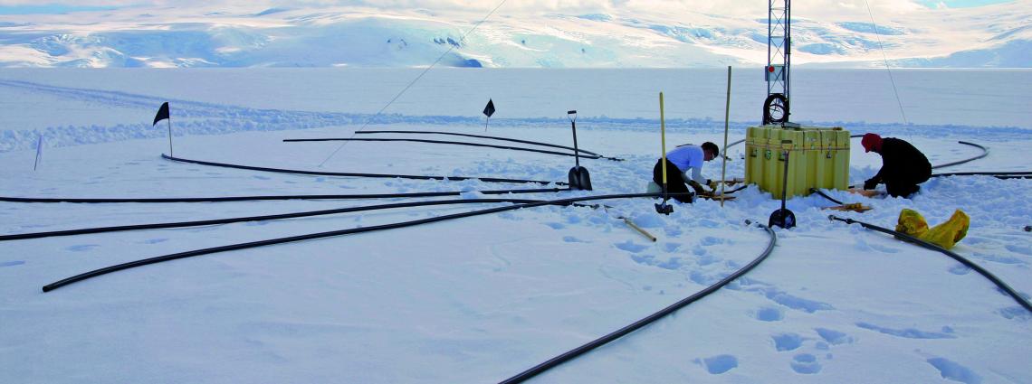
IMS 54, Palmer Station, Anvers Island, Antarctica peninsula
Palmer station and the local penguin colony
Since nuclear explosions have become very rare, almost all detected signals are from other events. These instruments are used to detect such non-nuclear events. The seismic stations can pick up events that warrant tsunami warnings. These signals are therefore reported to various countries. They were among the ones that allowed Japan to issue tsunami warnings before the arrival of the waves in 2011. The radionuclide detectors saw the ejecta from the Fukushima plant. The ultrasound detectors detected the eruption of Eyafjallajokul in 2010. The hydroacoustic detectors have seen signals from underwater events such as the deep Mayotte eruption. The demise of the Titan submarine was detected in real time by hydroacoustic detectors (it was quite a large implosion) although this was reportedly run by the US military rather than the IDC in Vienna. Two of the IMS hydroacoustic stations were well placed to detect the lost airplane MH370: one did detect a potential signal, but there was interference from a possible Antarctic ice collapse, while the second station was affected by a nearby ship.
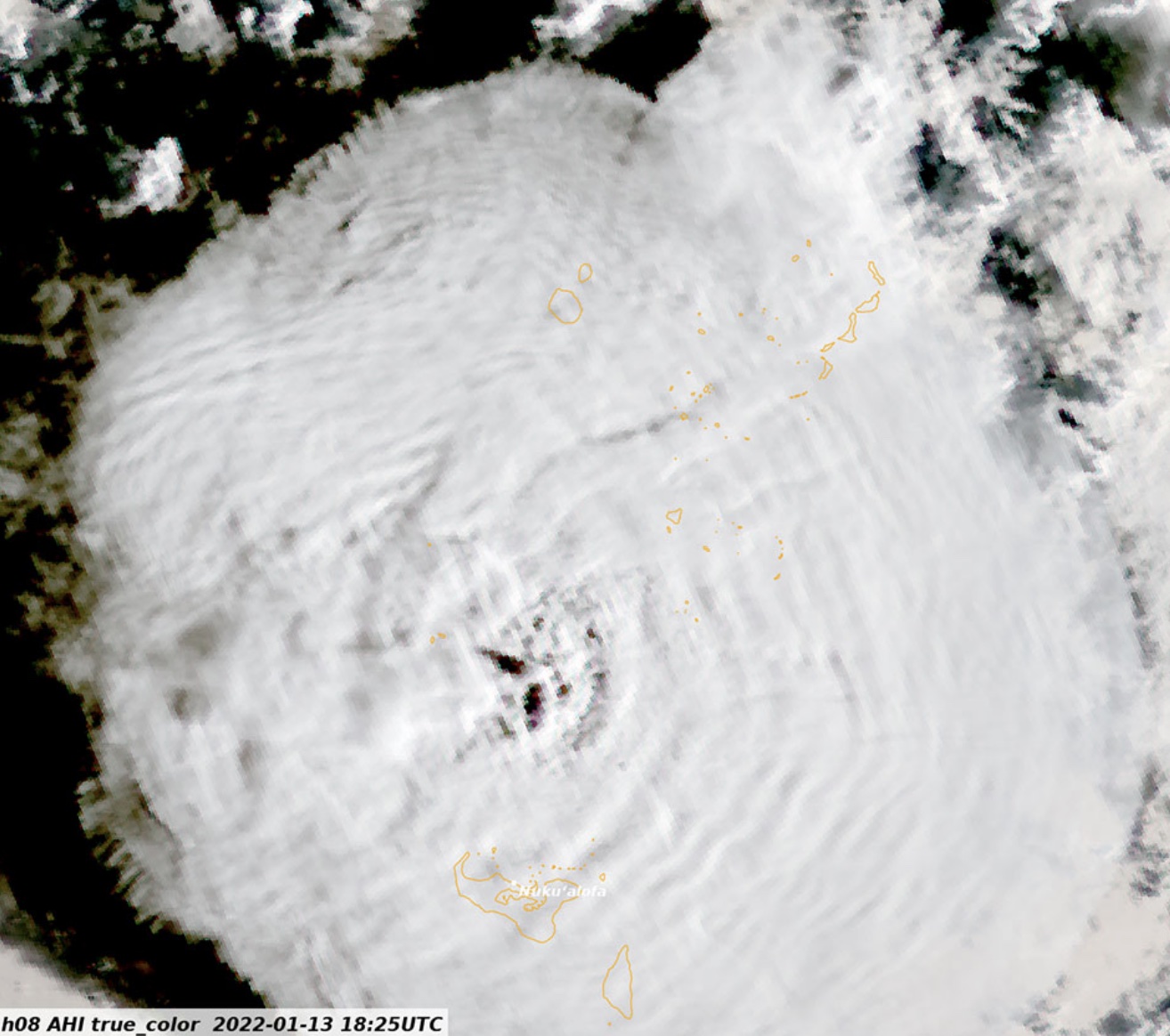
The eruption of Hunga Tonga on 15 Jan 2022 was picked up by much of the IMS network.

The stations of the CTBT monitoring network, or IMS
The goal of these systems is to detect large energy releases and to decide whether these are from nuclear explosions. The most common energy releases are from earthquakes. These come from large rock masses held in place by friction, and suddenly begin to slide past each other when the stress exceeds the friction force. Because the friction force between moving masses is much less than that between stationary ones, the sliding rapidly accelerates. True explosions act different but they are rarer. Some of the missiles used in the Russia-Ukraine war were strong enough to be detected by seismographs. Volcanic explosions can also produce a lot of energy: imagine a missile strong enough to excavate a crater several kilometers across! But such explosions are rare.
Hunga Tonga had a major eruption in January 2022. It was immediately clear that this was a large one, but the full size only became apparent in the weeks and months that followed. The islands of Tonga received a generous helping of ash. More devastating was the tsunami which overwhelmed some of the islands and caused damage and casualties across the Pacific ocean. It could have been much worse but the waves were mainly directed away from the nearest and populated islands. At Hunga Tonga itself, the initial wave may have been 90 meters high. The explosion had major impacts in the atmosphere. The wind speeds away from the eruption reached hurricane speeds, the ejected water reached the stratosphere. The pressure wave went around the world several times. In Manchester we detected the pressure wave 7 times. A lightning storm hit the rising column of water and ash, with the most lighting strikes every detected. One of the strikes was so strong it was detected in gamma rays, the first time this was ever done from lightning. The ejecta ended up in the ocean, but it was discovered that these debris flows had cut the communication cables to Tonga – 50 kilometers from the eruption. It turned out to be the largest volcanic explosion since Krakatau – not the largest eruption, but the largest explosion. It was an ideal test for the detection systems for violations of the Comprehensive Nuclear-Test-Ban Treaty
Wave physics

Explosions generate a series of waves, which can be detected at distance. Some waves travel through the atmosphere, some through water and some through solid rock. An explosion in the atmospheric will cause mainly atmospheric waves, underwater explosions give water waves and underground explosions cause earthquake-like waves in the earth. The CTBT monitors listen for all these kinds of waves.
Let’s first do some physics. A wave occurs when something is pushed or pulled forward, backward or sideways, and the moving particle then pushes or pulls the particle in front of it in the same way. The original particle ends up where it started, while the wave moves forward.
The best known type of wave is the sound wave. It is how we communicate (or at least it was until the invention of the mobile phone effectively ended communication). Air particles are pushed forward, they push the air ahead of them, etc. At the same time the air ahead pushes back, forcing the molecules behind to go back to where they came from. The wave moves forward at the speed of sound, while the air molecules themselves stay where they were. The speed of sound is 330 meters per second. The sound from an explosion 100 km away will take 5 minutes to arrive.

P wave
Sound waves can occur not just in air. They can also travel in water or in rock. The mechanism is the same, but they travel faster that way, reaching several km/sec in rock. The sound wave in rock from an earthquake is called the ‘P’ wave. ‘P’ stands for ‘primary’, as it is the first wave to arrive.
The second type of wave is where the particle is pushed sideways rather than forward/backward. It doesn’t work in air or water, as they don’t mind going sideways and don’t push back. But in rock, there is resistance. Rocks do not like being deformed this way and they push back. Now the wave travels the same way as before. This wave is called a ‘shear’ wave. In earthquakes it is called the ‘S’ wave, but ‘S’ stands for ‘secondary’, not ‘shear’, and it is called this because it travels slower and arrives later than the ‘P’ wave.

S wave

Because shear waves exist only in solid rock, if a P wave is seen but no S wave follows, it suggest there is liquid between us and the earthquake. This may indicate a magma reservoir, for instance.
Confused? This youtube video may help explain how a wave travels – or not.
In an explosion, the force (pressure) is directed away from whatever detonated. This is very good at generating P waves but terrible at S waves because there is little or no sideways motion to begin with. In contrast, an earthquake arises from movement along a fault, for instance the Andreas fault (just to scare the Californians among us). Now all the movement is sideways, so this is very effective at generating S waves but terrible at doing P waves. (It depends on the direction you are looking. P waves are generated along the fault line.) So this is a way to tell the difference between an explosion and an earthquake.
Waves can also travel along a surface. This can be a water wave on the surface of the sea, but it can also happen on the surface of the Earth. There are two types of these surface waves. In a water wave, the particles mainly move up and down. On a rock surface, the particles can also move sideways, similar to the shear waves that were already mentioned. The ‘up and down’ waves are called Rayleigh waves. The sideways ones are called Love waves. If you see an earthquake roll towards you, and your house is moving up and down before collapsing, it is Rayleigh wave. If the house is being shaken apart sideways it is a Love wave. Californians, take note.
Finally, surface waves can also travel in a plate of some thickness. Whereas Rayleigh waves only affect the surface to a depth of about the length of the wave, these waves affect the entire plate thickness in a quite complex motion. They are called ‘Lamb waves’. They occur for instance in the atmosphere, where the ‘plate’ corresponds to the troposphere. Explosions in air can generate such Lamb waves. However, atmospheric Lamb waves need a lot of energy to get started; they have been seen only after major events, such as Krakatau, Tunguska and solar eclipses. The pressure wave that circled the globe multiple times after Hunga Tonga was a atmospheric Lamb wave.
You may also have come across the term ‘gravity wave’. In most of the cases which we have seen, particles pull each other back to where they came from. In gravity waves, the pull-back comes from gravity. Clearly, this only happens if the wave is up and down, not sideways, as as gravity is not interested in sideways motion. Waves on the surface of the water act this way. As the wave arrives, sater rises; gravity objects and pulls it back. This mechanism can also work in the atmosphere. Because gravity is not affected by the boundaries in the atmosphere, such as the troposphere-stratosphere transition, gravity waves can extend across these boundaries, even into the mesosphere.
Hunga Tome eruption cloud. The wave pattern in the cloud are gravity waves
This is the end of the physics lesson. Time to wake up and smell the coffee.
Seismographs
All 50 or so seismographic stations picked up the signal of the Hung Tonga explosions. The figure below (as most pictures it is taken from Donner et al.) shows some of the signals. The traces are ordered in distance from the explosion. The blue circles show when the P wave from the onset of the eruption (just after 4am UTC) would have been seen at each station. The blue triangles show the same for the S wave: these arrive later, because they travel slower. The blue line shows the predicted arrival of the Rayleigh wave, the slowest of the lot at about 3.7 km/s. For the nearest seismographs, the signals of the three waves arrive near-simultaneously and become mixed up.

Seismograph signals from the Hunga Tonga eruption
The nearest seismograph show two more explosions, which happened at 4.15am and 4:18am. The orange and red points and lines show the progression of the various waves from these two events.
It is immediately obvious that the dominant seismic signal is from Rayleigh (surface) waves. The P and S waves of the first eruption are not visible on the traces. The P waves from the later eruptions are seen, but only at stations more than 5000 km away – for closer stations, the Rayleigh waves of the earlier eruption arrive before the later P waves and make them impossible to see. For the same reason, S waves are only discernible at the most distant stations. Where they can be seen, they seem similar in strength to the P waves.
For earthquakes, the S wave is normally much stronger than the P wave, because an earthquake originates in shear motion. That is not the case here, and it favours an origin in an explosive event rather than an earthquake rupture. The strength of the Rayleigh wave also favours an explosive origin, possibly near the surface.
Combining all the stations and extrapolating the signal back to the source, it is possible to see the individual events. This is shown below. The plot is logarithmic, meaning that a signal that looks two times stronger is in fact 100 times more powerful. There are explosive events at 4:01am, 4:15am, 4:18am (those two are by far the strongest), 5:30am and 8:30am. In between there is considerable seismic noise.
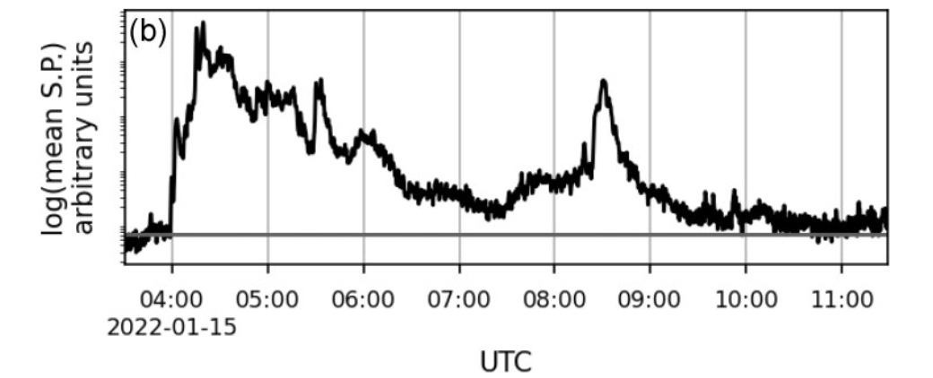
The seismic power generated by the Hunga Tonga eruption
The eruption started around 4am, building up a large explosion within a few minutes. After that the activity continued, with a sudden very large explosion 15 minutes later, following within minutes bu a second one. The activity was continuous until 5:20 when it dropped but quickly followed by a new burst. After 6:30 activity was low level, but with another large outburst at 8:30. The activity became very weak by 9:30 and had ended by 10:30 am. The complete eruption lasted 6 hours.
Infrasound
Infrasound is an atmospheric sound wave, in the form of a traveling pressure wave. Although called ‘sound’, the frequency is far too low to be picked by our ears. The frequency is milliHerz, rather than the few hundred Herz our ears are designed for! It traveled large distance using the stratosphere as a waveguide. Such a wave was first detected after the Krakatau eruption, In 1908, it was detected after the ‘Great Siberian Meteor’ as it was known at that time (now known as Tunguska) with an amplitude of 1.2 mbar in Irkutsk and 0.3 mbar across Europe. The Tsar Bomba caused around 2 mbar more than 2000 km away. In comparison, Hunga Tonga caused 5mbar at a similar distance, similar to the Krakatau wave. Clearly a lot of the explosive energy went into the atmosphere.
All 53 IMS infrasound detectors recorded the pressure wave. This is unprecedented. Because the travel speed is affected by the winds in the stratosphere and can vary, extrapolating back to the exact time of origin is not as accurate as for the seismic signal. The best results were found for four stations westward of Hunga Tonga.


Infrasound signal fro the atomspheric pressure wave
The infrasound waves show the sharp events at 4:15 and 4:18 am. The 4:01am event was only weakly detected. After 4:18, the atmospheric noise continued high until 4:30am. There was another explosion around 4:34am and a smaller one at 4:50am. This agrees with the high level of seismic noise until after 6am but the details are different. The sharp infrasound signals between 4:30 and 5am are not visible on the seismographs.
Hydroacoustics
The IMS contains 11 hydroacoustic detectors. Five are deep-water seismographs and 6 are hydrophones. These last 6 are used for Hunga Tonga. These stations are at a depth of around 1 km, which is the depth where acoustic signals can travel long distances.
Only the instruments ones with a direct line of travel from Huna Tonga. In several instrument, there were islands in the way which delayed the signal.


Hydroacoustic signal
The underwater signals differ from the other two in some respect. The early phase is picked up relatively stronger, and there is a quiet phase between the 4:15 and 4:18am events. A precursor event is seen around 3:45am, and there is an event at 4:12am not seen by the other methods.
The yield
The seismic signal has been difficult to assess. The body waves (P and S waves) have been used to assign magnitude, while the Rayleigh waves give a higher strength. Combining all seismic signals may give a magnitude of the three main explosions of 6. Converting this to energy would indicate 300 kton TNT. On the other hand, the strength of the atmospheric waves have been used to calculated as much as 100 Mt TNT. That is an entirely different beast! If that amount of energy had been used to generate seismic wave, an earthquake magnitude of 8 would have been possible. Clearly, very little of the energy went into the ground. This was not a closed magma chamber blowing up.
The energy becomes comparable to (but perhaps a factor 2 lower 4) than Krakatau. This was indeed a once-in-a-lifetime eruption.
The eruption
The different methods saw different aspects of the eruption. They agree on the duration, the presence of large explosions and the continuous activity. They disagree on the details, especially the hydroacoustics. The natural explanation for this is that the eruption occurred partly below water, partly above. The relative weakness of the seismic signal indicates a shallow, mostly open eruption.
There is little doubt that the eruption started below water. The eruption the previous day had removed the part of the island where the eruption occured, as shown by images taken afterwards. Therefore, the fact that the hydroacoustics picked up precursor activity missed by the other methods is understandable. The lack of seismic activity may suggest that the 3:45am event wasn’t explosive in nature. A vent may have opened. My thinking is that a small flank collapse may have started the events.
The 4:01am explosion was the proper start. It was strong in the hydroacoustics but weaker in seismic energy and infrasound, at lest relative to the events that followed. This again was mainly below water, as was the 4:12am explosion. The 4:15am explosion was very much larger. This was also the explosion that started the atmospheric Lamb wave. It was massive, the loudest volcanic bang for over 130 years.
It appears that the eruption started 150 meters under water. One suggestion is that the 4:01am event opened the conduit, so that water began to intrude into the magma. Such an intrusion leads to a phase of film boiling: wherever magma and water are in direct contact, the water boils in a thin layer. This can be stable for a brief period (minutes) if it happens under sufficient pressure – 150 meters of water will do for this. There is now a thin layer (film) of vapour which keeps the magma and water apart. Eventually, the boiling films become unstable and the vapour condenses back into water. This can happen naturally, or it can be caused by a new failure, such as a rockfall. Now water and magma are in direct contact. Within milliseconds, the pressurised water flashes back to steam, fragmenting the magma. The water at this point is supercritical, at high internal pressure. The new vapour wants to take up 1000 times its original volume. The water-magma mix explodes.
The eruption cloud was first seen by the Himawari satellite at 4:10am. (There are images every 10 minutes.) This indicates that the 4:01am eruption was already a large one which broke through the water surface and lifted a cloud to 10-15 km height. This explosion generated a loud hydroacoustic signal but much less seismic signal. My personal opinion is that this was a continuation of the large eruption of the previous day. The 13/14 January eruption lasted 22 hours with numerous individual explosions. It may have ended when the conduit became blocked, perhaps by debris or collapse. The 4:01am eruption was throat clearing: the loud hydroacoustic signal could indicate a slide. The explosion deposited energy into the water but less into the ground, so it was probably fairly open upward: this was not inside the conduit but at the top.
The process of water entrainment in the magma now began. At 4:12am there was a larger event seen (heard) in hydroacoustics. And at 4:15am came the climactic explosion, the one that pushed the eruption cloud into the mesosphere and generated the atmospheric pressure wave. The size of an explosion from water-magma mixing is determined by the surface area that is in contact. The enormity of this eruption would suggest that water had come in to the major part of the conduit or perhaps to the magma sill. The previous bangs had caused a large opening for the water to pour in. Pour in it did.
The next event was at 4:18am. But here the characteristics were different. The P waves of the 4:15 explosion started with a positive excursion: this was a high pressure wave radiating in all directions, i.e. an explosion. But the 4:18am started with a negative excursion, a pressure drop. This was not an explosion but an implosion. The 4:15 am explosion had blown out the magma. The 4:18am bang came when the volcano collapsed into the hole. This gave a bang as large as the preceding explosion, as it involved the same volume. These two explosions generated the large and damaging tsunami which spread across the Pacific ocean.
There was a poorly understood event around 4:30 and a larger explosion at 5:30. A large explosion at 8:30 finished the eruption: the plume from this again reached the stratosphere. It was not seen in satellite images because of the previous clouds, but probably reached over 20-25 km. Over the next hour or so the eruption wound down and Hunga Tonga was not heard from again.
The eruption was a low VEI-6 to high VEI-5 on the volcano explosion scale. That puts it on par with Pinatubo and Santa Maria, but below Krakatau. However, the energy deposited into the atmosphere was ten times larger than Pinatubo and was comparable to Krakatau, while comparable little energy went into the rock.
This is probably typical for shallow submarine eruptions. Santorini may have been like this, explaining the large tsunami but leaving little evidence in the ice cores. It is not the volcanic islands that are the problem. It is the ones you can’t see, or which only just break the surface. Think Bogoslof – or Iwo Jima.
Nuclear volcanoes
This study of the Hunga Tonga eruption used the CTBT network, aimed at monitoring for nuclear explosions. Did this network work? It showed that this event was not an earthquake but an explosion. It showed the importance of monitoring water, earth and wind. But did it show that this was not Kim of North Korea doing a Bond? Could it tell that this was not nuclear?
The fact that multiple explosions were seen with continuous activity in between is a pointer at a volcanic origin rather than a nuclear weapon – they tend to explode only once. The decisive data though came from the fourth element, fire. No radioactivity was detected.
An event like this may not re-occur for a century or more. Or it may happen again in 2024. In any case, the 2022 eruption was an opportunity to test a system we hopefully will never have to use in a time of anger. Nature is not friendly – but it is not our enemy either. It is not like us.
Albert, January 2024
This post is based on the following paper. The images are taken from that paper.
S Donner, A Steinberg, J Lehr, C Pilger, P Hupe, P Gaebler, J O Ross, E P S Eibl, S Heimann, D Rebscher, T Plenefisch, L Ceranna, The January 2022 Hunga Volcano explosive eruption from the multitechnological perspective of CTBT monitoring, Geophysical Journal International, Volume 235, Issue 1, October 2023, Pages 48–73, https://doi.org/10.1093/gji/ggad204

Tsunami aftermath at Tonga


Just an FYI on HVO website. They have either changed the website or they have a glitch. If you are looking for the monitoring data for the month or year it has been moved. It now sits under Science, science topics. The monitoring tab only has weekly data.
Mac
Now they’ve cancelled access to most websites/services of HVO. Only Multimedia works. Have they changed the rules for access?
I think they’ve just reorganised the site. If you go in the map the info for the gps stations and so on can be seen when you click on the relevant star or other shape.
Those stars were missing from the map yesterday but have re-appeared now. They are fixing the issue
Is Grimsvotn finally about to go? Apparently it dropped by a meter to the southwest, and a jokulhaup is likely to occur. Given that it’s the middle of winter this is very likely to be volcanic related.
A bit soon for a jokulhaup? But if one happens, it could trigger the eruption. That would make it a three-way race with Kilauea and Grindavik. Bets are open. All profits to go to the VC prediction service.
Hmm….
Saturday
06.01.2024 20:42:05 63.871 -22.413 5.4 km 2.4 99.0 3.8 km NNE of Grindavík
Thats a bigger quake than a while! maybe I shall stay up watching a little longer in view of Svarsengi must be close to over pressurisation.
These are 5km-ish. I think this is the dike finally being refilled after the reinflation at svartsengi – it’s in the ‘gap’ also. Should mean an eruption in 3 days or so
2.39 and a 1.78 right in there.
Yes, interesting. It was classed as a 1.7 initially then went up to a 2.4
Very close to each other on the dyke too.
There are two earthquakes at the same location, 30 seconds apart. One was the 1.8, the other 2.4.
What I saw Albert was 1.7 and 1,3 intiially then both were revised upwards.
I see. That would have been the manual re-assessment
I agree Albert and it reminded me of the need for those manual assessments as there must be a lot of input from the human brain as opposed to automatic input. AI will never overide the need for himan input. Well so far anyway.
Seems that the assumption another eruption at Sundhnjukur would occur at the same pressure point are incorrect. It reached that point a week ago and still going up unchanged. It is getting more likely that the next eruption will be larger which is obviously not great, just as well a wall is being built around Grindavik. Another eruption is basically inevitable, the sooner it is the better as pressure will be low and consequently so will volume and total scale.
Old Sundhnjukurhraun floods both the north edge of Grindavik and the whole Svartsengi/Blue Lagoon area, in what seems like a single eruption, probably the last of many in a rifting event like now. Eldvorp and Arnarseturshraun are of similar extent and origin… its an unfortunate reality that Grindavik is unlikely to get out of this unscathed
Updated 5 January at 14:30 UTC
The rate of land uplift near Svartsengi continues to decrease.
This statement is taken direct from the IMO website.
Thinking they had some information I didn’t, I waited to see the latest GPS readings but I can see no indication that this statement is true. The land seems to have risen at a similar rate for the last five days.
How they can justify opening the Blue Lagoon in these circumstances I fail to understand.
I tend to agree with Chad’s assessment.
Seems to me that the last time they reopened the Blue Lagoon, there was an eruption that night. Perhaps a repeat is in order?
It slowed down for a couple of days, then seemed to start increasing again (at some stations anyway). As a consequence, the decrease is no longer obvious. The most sensitive stations seem to be HS02, Svartsengi, Grindavik (GRIV) and Skipastigshraun. The first three, plus Thorbjorn surround the chamber/sill I think.
I am glad you said “Another eruption is basically inevitable”, because I was begining to wonder if it would erupt again at all. I did wonder why it wasnt erupted by now but was a bit scared to ask. It is good that it is delaying, for the sake of Grindavik anyway. Hopefully the amount of berm that they have already built would at least delay things enough for people currently in the town to leave again. Just looks to be a really difficult problem for Grindavik people if the eruption happens soon though.
A bit of delay is good but the longer it goes the bigger the next eruption will be. The walls are better than nothing but are still not great and historically have not been very affective (Kapoho 1960). Theres also the small possibility the fissures will directly breach the wall, which is also more likely if things tale a while to get going.
I agree letting the Blue Lagoon open is weird, especially when the comparison to Krafla has been made which was a repeating rift event. The way the statistics of intrusions erupting gets thrown around like the risk is low is dangerous too. Most intrusions are in rifting events and it is very unusual not to get any lava surfacing during one of those. The 10% rule of magma to lava in Iceland is based on magma generated vs erupted lava meaning most generated magma fails to reach the surface, but doesnt actually mean only 1 in 10 intrusions reaches the surface. The actual data for Krafla shows that after 1980 every intrusion had a major eruption, it was far from random. Rifting events start with plate movement that allows magma to intrude and after a while there is no more room underground and it all goes out. The Grindavik rift did stages 1 and 2 in a single sitting back in November, theres nowhere left underground to fill and every intrusion now is going to be at the surface in an hour. IMO and the volcanologists need to be conservative but anyone saying there is a meaningful chance that the next intrusion fails is being very optimistic. Not to mention it will need to go somewhere underground regardless and that did a lot of damage to Grindavik anyway. Best case for Grindavik is Svartsengi making a different rift but theres no present evidence
Thanks for the explanation. I had been fooled into thinking there would maybe be just another ‘dry run’ so to speak. So as far as I can see it at the moment is if the rift opened further north would be the best thing for Grindavik but sadly not so sure that is likely to happen because of the amount of quakes close to the area of Grindavik. Perhaps that reasoning is a bit simplistic anyway. It will go where it chooses and as you pointed out, a rift ‘could’ open right through the berm anyway.
I’m guessing that they are working on the assumption that the next eruption will be at or close to the site of the December eruption. Or if it isn’t, an earthquake swarm will precede it and give some warning.
The trouble is that we don’t know what the precedents to an eruption at Svartsengi, itself, will be and whether or not there is likely to be enough time to issue a warning and evacuate safely.
From what I can tell, only parts of the Blue Lagoon are open (mostly the restaurants). Suspect that permitting the Blue Lagoon to open is a committee decision …
They judged the threat for Blue Lagoon as “yellow”, because fissures won’t happen there. But … lava flows can’t really be excluded there, if physical laws decide so.
Due to modern digital instruments we can better observe the whole development of the early Fires stage. During the Middle Ages they could only rely on their humans five senses: See lava, hear volcanic thunder, smell&taste sulfur, feel tactile earthquakes. Now we’re glad to observe more than this. But actual eruptions still bear some surprise like 1210.
You can’t say precisely where fissures will happen until they actually open.
There was discussion whether the sill below the area of Sundhnukur acts like a (temporary) Central Volcano and magma chamber. This structure could act like Krafla’s Central Volcano that directed many eruptions, but wasn’t active 1975-1984. After the establishement of the central magma chamber several intrusions/dikes will likely move around SW and NE during next 30 years. How many eruptions will happen vertically on the central magma chamber/volcano? How many will move into the fissure swarm?
Maybe the single measurement point that is the up-component of a single GPS station is not a perfect indicator of the system pressure. Consider the fact that we have multiple sources of ground deformation at play here. There’s the obvious sill intrusion under Svartsengi/Þorbjörn, but there’s also the huge displacements caused by the dyke intrusion, plus the general rifting movement of the tectonic plates along a large portion of the main Reykjanes fault. I think the fact that the dyke and the eruption happened at the same level of the Svartsengi GPS was just a coincidence.
The uplift is a good indicator that we haven’t seen the last of this, but I doubt that the absolute value of the uplift is a good predictor for when the next part will happen. I know I did a prediction myself (January 10), but that was (mostly) meant as a joke.
Perhaps uplift has to reach or exceed the highest point?
An eruption is expected within hours or days according to Þorvaldur Þórðarson.
Source: https://www.ruv.is/frettir/innlent/2024-01-08-ae-fleiri-grindvikingar-gista-heima-401441
I have also wondered about that Merlot and also wondered if that point was a true breaking point or a misplaced mark.
I have also wondered if perhaps the area above the magma intrusion has become more ductile, meaning that it may even have to excede that high point before an eruprption. Is that even possible?
I honestly think, as I thought before the previous eruption, that no one can be expert enough to say when an eruption can occur. With Reykjanes volcanology I think we are travelling in unknown territory that no living human has explored before.
Therefore there ARE no experts.
Has HVO closed the website for non-US visitors? I only see the multimedias, but can’t access anything else.
Does not appear to be limited to non-US visitors. I also get “You are not authorized to access this page.” (https://www.usgs.gov/volcanoes/kilauea/volcano-updates)
My guess is it is not intentional and will be fixed soon.
It happens on the general USGS website. HVO only allows access to some multimedia websites (f.e. December map).
But other Hawaiian sources are working. Big Island News published warning about floods in Ka’u desert. So a water flood may precede a possible eruption. Erosion of tephra/aged lava can be dangerous and remind to a lahar. It would also increase the risk for phreatomagmatic explosions, if magma hits groundwater.
Indeed the present radar shows a lot of rain in SE Big Island (SWRZ area):
 ?refreshed=1704649406450
https://radar.weather.gov/region/hawaii/standard
The wet side of Big Island its basicaly Singapore but outside the equator, Hilo was very similar in apparence and same vegitation and also pretty hot at noon even in winter. The wet side is wet and warm enough to have a lowland tropical rainforest classification in coastal areas in north east parts of the Island. Hilo and lower Puna looks very equatorial, and soon will be a copy as invasive tropical plants from the plant trade runns over everything on the Island.
But the hottest areas of Big Island is lowlands of Kailua Kona and Kohala desert, they pretty much always go above 30 degrees c even in winter, making them as hot as the equator, but they are pretty dry and sunny and haves an India savannah looking forest cover. The hualalai and mauna loa lava fields towards waikoloa coastal plains are probaly getting up to 50 degrees c as the black basalt soak up the sunlight, something Chad woud not like to be stuck in.
That’s the normal climate. It looks as if currently there is a hard rain in the deserts of Big Islands. Rain in a desert is always a threat for floods with a lot of erosion. In the volcanic desert of Ka’u floods like this it can do a fluvial sediment transport of volcanic materials (ash, old lava) like a lahar a long time after the eruptions. In Alaska they sometimes have the Aeolian sediment transport for ash. More than 100 years after Novarupta, occasionally there appear ash plumes created by the force of storms.
Kau desert isnt a desert technically, more of an open woodland that is buried by ash and exposed to a lot of acid rain. It rains almost as much there in a year as it does on the green side of Kilauea but the soil is very porous. The Kona side is also not quite a desert either although is more arid for sure.
latitude 19 – 20 but as hot as many equator locales even in winter, was very supprising for me as I spent my first time in Big Island in january. Was defentivly ALOT hotter than canaries was in same season. Kailua Kona was unbearable after lunctime 31 c and high humidity. Only the coasts are tropical, the higher interior is temperate
Big Island is probaly the warmest tropical Island locale at latitude 20. And I dont think it woud be any diffrence if Hawaii was on the equator ( but woud be no dry zone )
During Last Glacial Maximum with low co2 levels I can imagine that Big Island and equator had a very pleasant weather, about 24 c in lowlands in Noon. Most of Mauna Loa and the highlands woud have neen very cold back them, Ice sheets covers Mauna Loa and Kea and halema’uma’u may have gotten some seasonal night snow in winter.
During PETM the lost Big Island that was back then woud probaly have avarged 43 c or more in lowlands for comparsion
https://news.climate.columbia.edu/2021/05/12/during-the-last-ice-age-the-tropics-were-colder-than-we-thought-bad-news-for-us/
https://en.m.wikipedia.org/wiki/Nintoku_Seamount
This is that lost island. Its not clear if it was actually active at the time of the PETM though. Maybe Hawaii didnt have a hyperactive island at the exact time of the PETM. The next youngest former islands are Jingu and Ojin seamounts which might have been in shield stage at the PETM but little information on them.
The next island after that is the massive Koko seamount which was probably similar to the Big Island or Maui Nui but it was at least a few million years younger than the PETM.
Thanks chad.. and probaly woud have been a dangerous climate at sealevel for humans, very humid and perhaps 40 c or much more depending on season. Its the high humidity of Supergreenhouse phases thats the killer of human time travellers combined with higher than todays tropical temperatures
Today equator max out at ( ”only” 31 – 32 c in shadow) still even that feels awful with the high humidity
Jesper, I for one just love tropical orchids. So I am probably an outsider in hoping to see orchids run wild in the Hilo and lower Puna areas. I think at the last eruption in the rift zone there were some orchid nurseries over run in those areas but my memory is faulty so I cannot be sure. It certainly seems that those areas are perfect for raising orchids.
I did buy orchids in the town of Volcano when I was there last about 6 years ago and I would love to see them growing wild too! It was exciting to see tree fern growing and other vegetation. Some varieties I was told were just weedy orchids but as a horticulturist new to me plants are interesting plants not weeds
My daughter passed her love of orchids on to me, She would buy neglected ones at a very discounted price and nurse them back to health in the UK. She even wanted to start growing her own from seed as she managed to fertilise some in the UK after researching the method online. Then she married and had children, so now has no time or money at all to spend on orchids, especially as one child has a serious congenital heart defect that means she can no longer go to work until the child hopefully survives further operations that are necesary to keep him alive. But my own dream has always been to go to a tropical area and to see them growing in the wild. One day maybe.
Here in the UK there are few varieties of hardy orchids but are small plants like the bee orchid, which I have found growing in a location in UK that I will not disclose, as they are now an endangered species.
We love orchids. Beautiful, long lasting and easy to get back to flowering with sufficient neglect. We used to have quite a few but not as many now after a mealy bug infestation – it turned out neglect was not the solution to everything orchid. But it is close.
Sea surface temperatures during the PETM ( if it pops up )
Paleocene-Eocene Thermal maximum is one of my main intrests as well, because it almost became an alien planet, Earth was competely covered in tropical jungles and swamps, and the seas in many areas became as hot as bathtubs. Its the most extreme greenhouse since Siberian Traps. The Equatorial rainforests took the heat well despite 46 to over 50 c temperatures in congo and amazon. Many parts of the middle latitudes in PETM was warmer than equator today so around 35 c in france and germany in some models. Some reptiles got gigantic too in these times as hot humidity allowed larger bodies
Polar and Subpolar regions also warmed to tropical climate temperatures at PETM, Sweden and South Greenland woud have avarged 25 c or more in air temperatures. The high arctic woud have warmed to 17 to 20 c at the peak of PETM with 24 c summer sea surface temperatures, so a warm july day in PETM northen greenland coud have been 28 c to get souch a polar sea surface temperature. Fossils or crocodilian scales of PETM age are known from the Arctic Ocean. Primates fossils are also known arctic canada ( that was roughly same latitude back then, and primates are no fans of cold. polar winters in early eocenes heatwave probaly got no lower than 15 c. Antarticas coasts where fringed with palm trees back then.
During Paleocene-Eocene thermal maximum the hydrological cycle vent into overdrive due to hot oceans and warm air temperatures so an insane ammounts of global rainfall and that suits well with global tropical rainforests fossils, a warm wet world. Its incredible how strange earth was back then, competely covered in tropical rainforests. Many areas of PETM woud be deadly for humans with an combination of very high heat and humidity, it woud be impossible for humans to live at the PETM equator or anything at all below latitude 35 with over 40 c in shadow and saturated humidity woud kill a person very quickly back then. The seas near equator woud been almost unlivabley hot for most lifeforms too. Hard to imagine Scandinavia at least the sourthen parts being as warm as singapore today with giant snakes
Early Eocene was green and muggy and overcast and totaly alien, probaly closer to a star wars planet than earth is today. We normaly acossiate deserts and savannahs with hot climates, but these only appeared when the drier Ice Ages came. Tropical Rainforests are probaly the default global biome of a supergreenhouse earth like PETM.
The extreme global heat during the eocene optimum had many background causes souch background volcanic co2 outgassing. But PETM spike was probaly caused by the immense NAIP trap eruptions. I wants to write an VC article about the PETM and trap volcanism and its geochemical signatures, but Im sick and Im very busy so dont feel I have the energy for now.
We humans are lucky we started changing a cold planet that does already not have souch a mad climate as preindustrial setup. Eocene heatwave woud likley not allow human evolution if it never stopped
Both Scandinavia and UK woud have looked very much like equatorial South East Asia back then in vegitation despite being only a few latitudes south of today. Albert is probaly very familiar with the London Clay deposits. South East England has been was as a paratropical rainforest fringed by coastal mangroves… and giant sharks stalked the warm waters
Thats what little extra co2 can do and was from volcanic origin. Scary is that we human are putting in co2 in the atmosphere much faster than the PETM did
“I wants to write an VC article about the PETM and trap volcanism and its geochemical signatures, but Im sick and Im very busy so dont feel I have the energy for now.”
I hope you feel better soon and recover quickly, Jesper! I would love an article from you on this topic, paleoclimate states & differences to today is such a fascinating subject.
yes NAIP flood basalt eruptions co2 gas have been suggested as the cause of the ultra heatwave in Early Eocene. It woud be massive fissure lava eruptions and pheratoplinian eruptions in wast tropical rainforests at high latitude 50 s with small primates and giant land crocodiles looking on the show. Global supergreenhouse conditions allowed tropical primates to migrate over greenland and into north america. Then the Iceland land bridge broke up and tge populations became isolated.
We often acossiate deserts and scrublands and svannahs with warm
climates and global warming.. but ironicaly they are enviroment products of the glacial period we live in. The colder earths gets the drier it will get too. Deserts thrive best during the Ice Ages .. with cold oceans, dry atmosphere and not during a supergreenhouse Earth like PETM.
true deserts only started to appear in pliocene I think as the world was cooling down
The true natural state of a hot supergreenhouse earth is rainforests and high rainfall from warm seas and warm air holds more moisture than cold. Eocene was rainforests everywhere, even in mongolia and siberia
Thank-you for sharing your knowledge about this climate optimum, Jesper!
I imagine a lot of tropical cyclones on worldwide oceans, also monsuns in countries that don’t have them now.
Geological interesting is the high sea level. It decreased the erosional force of water/rivers (together with a lot of tropical/subtropical vegetation) and often created soft, flat landscapes. A big mass of the whole landscape was eroded into the oceans during Ice Age. The location of many rivers shifted a lot after this climate optimum.
The Baltic Sea was a large river, maybe the size of present Wolga, that flowed from St. Petersburg over Kopenhagen and Jutland, where there was a river delta like the Rhine has around Rotterdam. Without glaciation all this river system would still be present. Sweden today was a continental nation without any sea access. The Nordish and Russian cold air would have it much more easier to get to central Europe.
Thanks PETM is probaly the hottest and most humid that Earth been since complex life evolved and got into land. The cause was high co2 levels. Palm trees ( coconuts) grew in south greenland and alaska and gigantic snakes and turtles lived in antartica that was polar latitudes even back then. Sweden was competely tropical back then, I think all of it, despite being only a few degrees south of todays latitude.
Its an Earth that was nearly competely tropical, competely covered in wet forests. The coldest was polar regions ( and never got colder than the avarge winter in New Orleans so +16 c woud be a super cold PETM winter night in Antartica. Compared to – 96 c today, but the ice itself makes it much colder than it woud be without ice even today in an Icehouse planet.
Its an Earth so bissare and alien its hard to even imagine that! equatorial seas became hot 40 c tubs nearly unlivable
I didn’t really know that PETM was so hot. I rather thought that Cretaceous climate was last climate optimum and afterwards a slow cooling through Tertiary age (Paleocene, Eocene, Miocene, Oligocene).
The PETM climate is like a different planet, it feels like a step towards Venus, but with water atmosphere. It likely supported the sedimentation of coal by a lot of tropical trees and vegetation – even on Svalbard, where they had coal mines.
And apparently a type of fern growing in the arctic ocean helped bring the earth out of the PETM state due to overgrowth; didn’t something similar happen in the Carboniferous that resulted in an ice age? It’s been a while since I’ve researched this stuff.
Azolla I think.
Yes, that’s an important way to reduce CO2 from atmosphere. On longterm I’d also assume that limestone played an important role during the evolution of our moderate climate. The Mediterannean Sea is filled with masses of limestone. Croatia is famous for its karst landscape which is a spectacular type of limestone landscape.
Tropical Cyclones woud be able to stay tropical warm
core right up to Iceland IF Earth was this warm today. PETM poles where still subtropical, but hot enough for crocodilians and palm trees and warm enough for primates to endure the polar winters. At sealevel frost was non – existent at PETM.
Reading geosicence data the co2 levels coud have been anything from 2500 to over 4000 ppm during the peak.
PETM happened during the massive NAIP basalt eruptions that formed giants causeway as a part of the Thulean LIP.
Interesting to imagine how Tropical Cyclones meet the early stages of Iceland’s volcanism. Maybe Iceland was like Big Island today, but with more Jungle that was occasional burnt by lava floods.
The PETM climate really sounds like Congo or Amazonas Earth. Imagine Rain forests all over the world. Did deserts survive? But I’d assume that they got a lot of erosion, because Monsun/rain seasons would be very severe.
Yes . ) the entire planet being a super malasyia, completely green, cloudy steamy and wet, basicaly a jungle planet. But most of the PETM earth woud be unlivable for humans, the equator warming to well over 40 degrees c with super high humidity, you die from heatshock. PETM woud be a supernasty place,,full of insects, diseases and agressive crocodilians and mosquitoes and a heat and humidity thats even very nasty at latitude 45, and you woud wander endlessly through dark forests always wet and feeling hot…
Jesper you need to do an article on this stuff, I’m serious. I could read you discussing this subject for hours. You paint extremely vivid pictures.
No deserts I think mostly rainforests, the heat skyrocketed the humidity. cO2 of 4000 ppm made this extreme hothouse possible
Jasper, you are from a cold climate and are genetically not predisposed to exist in very warm climates.However those of us who have lived in warm climates are able to deal with the heat with out such dire consequences. Even more so people who have lived in the tropics for thousands of years. For me 30°C isn’t unusually warm and vigorous sport is still played without ill effect. Even at 40°C normal physical work continues. Physical adaption to your environment is an amazing thing.
You woud never be able to adapt to a 43 to 46 c equator with max humidity. You cannot loose your body heat and dies from heat – shock. We humans are evolved to live in hot dry conditions in the savannahwhere sweat can evaporate. PETM became a hot steamhouse that we are not evolved to be in.
I just thought about the limestone production during Cenozoic Age. Was the PETM an era of forced limestone production? Do we know important sediments from this time? Cretaceous was the last important limestone age for Europe with the soft Chalk cliffs of Dover or Moen (DK). But I don’t know what was added during Cenozoic Age.
Not as much as cretaceous, because sealevels while much higher than today,they have been dropping since the cretaceous high sealevel stand. Seafloor spreading was slowing down in the non pacific oceans as meozoic was comming to a close, and mountain building caused land uplift.Still despite that, PETM had much higher oceans than today as it was icefree and warm. PETM had widespread water sedimentiation in Europe, but not as massive in scale as meozoic that had hyperactive ridges pushing up the oceans. Cenozoic limestone is not as extensive as Meozoic ones
Some imaginary habitable exoplanets with large oceans and hyperactive tectonics and a denser atmosphere ( Super Earths ) coud have PETM as a standard world. A denser atmosphere than we have in a habitable orbit coud be very useful for some orbits.
5 .. 6 .. 8 atmospheres of nitrogen.. an Earthlike mix is breathable all way up to 6 earth atmospheres of pressure. A denser air pressure evens out the pole – equator temperatures gradient as it traps sunlight better. And much less co2 will be needed to keep the planet warm. In a correct distance from the sun to balance the greenhouse effect. Souch thick aired worlds coud have worldwide warm tropical conditions with more air pressure than we haves as the denser air holds heat better than our atmosphere does
Earrh woud overheat with that pressure, we are too close to the sun, But other exoplanets in other orbits coud benefit alot from having souch dense atmospheres, and have much more globaly mild climates than earth does, no Ice Ages and poles unfrozen and green even with low co2 levels. Souch an air mix woud be even more habitable than ours, as partial pressure on co2 and oxygen woud be higher than ours. Dense atmopsheres coud make cold orbits habitable.
Earth does not have to be ideal at all..
Weird to imagine the coasts of northen siberia, covered in tropical mangrove forests thats been found in deposits and drill cores. That coast was even back then at similar latitudes as today. Thats what some extra volcanic co2 can do.
And South Greenland being almost as warm as Phuket in Thailand today. Its almost un – imagine- nable an Earth like that as Volcanophil says
Some comments on GeologyHub’s youtube video that seismicity has been detected around the magma chamber of Pico de Tancitaro in Mexico. It’s just below Paricutin on a map. Was Paricutin not just a parasite cone of this huge stratovolcano? They look very close.
The paucity of quakes the last 12 hours in the Reykjanes Peninsula makes me wonder if we’re close to another fissure eruption? Some of the GPS stations are showing northward movement the last 3-4 days. See https://en.vedur.is/earthquakes-and-volcanism/earthquakes/reykjanespeninsula/
Monday
08.01.2024 18:03:27 63.870 -22.400 3.3 km 3.5 50.5 4.0 km NNE of Grindavík
Obviously not checked yet as only 50% accurate but could this be the start!
Nothing appeared on DAS which I would have expected for that magnitude and location. Probably weather related..
Vafri showing it as a 1.5 so probably downgraded already. and just checked \grindavik drumplot and it shows a small quake. Panic over.
If it checks out at 3.5 (which it quite likely wont) blame Randall for speaking of a paucity of quakes.
Aaaand? It was a piddly little 1.1 quake. Still I enjoyed the adrenalin rush!
The northerly motion is reversing on most stations.. possibly weather related as even Krisuvik was moving north.. something wasn’t adding up..
It is warm, wet and windy in SW Iceland right now. The weather turned yesterday and looks to stay this way until the weekend. The biggest indicator that an eruption is close is that the Blue Lagoon hotels open up tomorrow. People will be able to spend big kr for the privilege of sleeping on a volcano…
And the joy of running away in their underwear in the middle of the night.
On the map the Blue Lagoon looks as if it’s well protected by the saddle between Thorbjörn and Sylingarfell. On this saddle were old craters/fissures that may serve as a natural lava barrier. But in worst case the volcano can indeed surprise us all (and the scientists).
Poor weather at the moment may make weak earthquakes hard to detect
New News: https://en.vedur.is/about-imo/news/a-seismic-swarm-started-north-of-grindavik-last-night
Anytime since 1-2 weeks they expect the eruption to begin suddenly. But the volcano appears to play with the scientists.
The high plain “Dalahraun” between Sylingarfell and Fagradalsfjall’s plateau is likely the place of the maximum output of lava during the last Fires there. It is also the area which is close both to the location of December 18th and the next eruption. If this area acts like a “Central Volcano”, it may get the majority of eruptions, but intrusions may also go NE into Fagradalsfjall’s lavas and SW towards Grindavik.
The latest US mission to the moon appears to have failed after a fuel leak. It was carrying human remains to the moon. I can’t say I was particularly happy about that: only people who have been to the Moon themselves should have earned the right to be buried there. Anyone else is just memorial pollution. I also felt a manned mission should require that the people on board are alive. But not good for NASA – haven’t been able to land on the Moon for 50 years and now can’t even get close.
I totally agree with you. The moon is a pure and relatively unpolluted area and should never be allowed to be polluted by human remains. I would go even further than you and suggest NO human remains at all be allowed to be sent there.
Peregrine One was carrying far more than human remains. It had quite a few payloads, such as the six micro-rovers for Mexico.
The human remains for Celestis would have stayed within the lander, so what harm are they? I rather like the concept (of various paying customers, not just Celestis,) because it defrays mission costs and does no harm – and certainly no more harm than the 12 other non-science “timecapsule” “plaque” and “art” payloads on this mission. There’s even cryprocurrency from The Seychelles. It was spare upmass capacity, and a very tiny amount of mass at that, so why not sell it to defray the mission cost?
And BTW, although NASA is paying for much of this program, it’s not providing anything in the way of launch or operations, aside from use of its Deep Space Network and some of the science payloads (Five, if memory serves). The spacecraft builder and operator is Astrobiotic, one of NASA’s commercial partners in the CLPS (Commercial Lunar Payload Services) program.
It’s worth remembering that the reason NASA funded CLPS mission series (this was merely the first one) was to enable low-cost commercial access to the lunar surface. I for one would love it if it works, because it would open the door to low-cost lunar science opportunities to universities, etc.
An example of this low-cost lunar access concept was on the mission; a student designed lunar rover, Iris, from Carnegie Mellon University. It’s tiny, about 2kg, and would have tested some new concepts, such as carbon fiber for the wheels, plus navigation and communication systems. It’s also, IMHO, a very good thing for science students to be able to work on such projects.
Opinions will differ on this. But who has the right to decide that the moon can be used as memorial cemetery? We don’t view our own remains as just another payload – if we did, it wouldn’t be there. Burying someone creates a sense of ownership. Who does the moon belong to? Anyone rich and famous? I adhere to the philosophy that people should be buried in a place where they have lived. Armstrong would have have stayed on the moon had he died there and that is fine and correct. But for the people on board the peregrine 1, it was just an ego trip. That is not what the moon is for.
As for the mission itself, NASA has chosen this way to go back so bears responsibility. Their own efforts have become far too expensive – they can only afford one launch per year! In the mean time other countries have had no problem landing on the moon. What does this tell you? Cheaper – faster – worse?
Nasa has to use the SLS because of US politics and some other bs. If it was up to then on their own they probably would have just put everything on a few Falcon Heavy launches. I have seen excuses why that wouldnt work but surely it would cost way less than a 4 billion rocket to fit Orion onto a Falcon core, and stick on a few of the solid boosters that are used on the newly flown Vulcan or outgoing Atlas. Or just build a Falcon series rocket powered by a Raptor engine as was that engines original use case.
The fact Starship has actually got to space on its second fully stacked flight, which is historically a rare thing for a developnental rocket to do so early, should be enough to show how obsolete a lot of the Artemis hardware actually is… SpaceX is the only reason the US even has a say in anything to do with what goes on above the atmosphere at this point.
Chad, regards SLS, you’re right, that was mostly political. IMHO, it’s also an utterly massive boondoggle. Even if we ignore that utterly astronomical cost (exceeding two billion per launch, not counting development) and the low launch cadence (one every year and a half or so, due to manufacturing constraints), SLS/Orion is unsuited for either Lunar or Mars missions. SLS (even the as-yet undeveloped Block 2) can’t do single-launch landing missions like Apollo could, because SLS/Orion can’t reach and return from low lunar orbit. It can only do high lunar orbit, so the lander has to be far more massive to attain the needed delta/v to make the trip from HLO (high lunar orbit) to the surface and back. So, you have to launch the lander and the capsule/service module separately.
The initial concept for SLS was indeed political; it’s nicknamed the Senate Launch System for a reason. Congress came up with the specs for it (!!!), and chose it because the Ares system (Constellation) was judged too expensive (Which it was). SLS, of course, has cost vastly more. Even congress largely sees it as a boondoggle, as evidenced by the fact there’s now partisan finger-pointing going on. However, this was a very bipartisan boondoggle, so it’s in the interest of both parties to not admit its faults. Thus, it lumbers on.
As for other options, my preference was to build a service module for Dragon 2 (which was designed to accommodate a beefed-up heat shield needed for lunar return), to replace SLS/Orion in the lunar mission architecture. Falcon Heavy could handle the launch and trans-lunar injection, at about 8% of the cost of SLS. FH doesn’t have the TLI mass capability that SLS does, but assuming Orion’s mass doesn’t increase yet again, the Orion/SM wet mass, at 26 tons, is within FH’s TLI capability of 28 tons (In expendable mode). Dragon 2 with the Orion SM would be better (that could reach low lunar orbit due to Dragon 2 massing about 1/3 less than Orion).
Starship? That’s (The upper stage ship) already NASA’s pick for a crewed lander. So, just replace SLS/Orion with FH/Orion (assuming Starship isn’t rated for reentry by then). The argument against this is FH isn’t human-rated. Neither was Shuttle, of course, but that’s forgotten. So too is the fact that human-rating FH would not be hard. The real reason is doing this leaves SLS with nothing to do, and that’s a political embarrassment. The answer is easy; rename the Starship system the Starship Launch System (thus abbreviated SLS) 🙂
Albert, IMHO differences of opinion are not only important to the scientific method, but also make the world far less dull. 🙂
As for the question of who has the right to decide that the moon can be used as a memorial cemetery, would it not also follow that who has the right to decide that it can’t be?
You mention Neil Armstrong, which is a very good case on point. He was both the first to set foot on the moon, and the first to use the moon as a memorial to a departed loved one; he placed a memento that had belonged to his dead daughter on the Sea of Tranquility. I see no harm in that.
I’ve never heard that burying creates a sense of ownership? There are, after all, a lot of US military cemeteries in Europe, and I’ve never heard anyone claim that that creates US ownership of Europe. Likewise, scattering ashes, both on land and at sea, is common, and I’ve never heard it imparts ownership.
Personally, I consider the Celestis concept rather silly (As you say, an ego trip), but I don’t see the harm. I likewise consider the other 12 tiny non-science payloads aboard Peregrine to be rather silly, in some cases moreso (Cryptocurrency on the moon…), but I don’t see the harm, plus I like the cost defrayment.
NASA chose this method in large part as a R&D program to develop robotic lunar landers, which are needed for actual Lunar exploration (Such as the next one, also by Astrobiotic, called Griffin, carrying a large NASA rover to the lunar south pole, due to launch on a Falcon Heavy in a few months). Robotic landers will also be needed for supplying any manned base established on the moon. Honestly, I’m not too concerned about the latter, because I consider NASA’s current path to be about as likely to establish a lunar base as I am, though for robotic exploration, small landers that are cheap enough to use often are crucial (And the landing systems and tech do need testing). The idea is to make them cheap enough to use often, and this kind of path is IMHO probably the least bad option. (I don’t trust NASA to do something like this internally, because if they did, it’d at best take many years, and be insanely expensive). And you’re right, landing a lander on the moon isn’t all that hard, it just requires closed-loop terminal guidance based on doppler radar. Nasa did this in 1960, with the Surveyor lunar lander series (5 of 7 landed successfully), which does rather beg the question of why they can’t do it now…
As to NASA bearing responsibility, as far as I know there’s no stipulation in the contract regarding not selling spare upmass, to Celestis or any of the other 12 non-science payloads. The fact Astrobiotic was able to sell the spare upmass reduced the contract amount, so NASA benefited, and so did US taxpayers like me. Absent a reason, why would they do otherwise? IMHO, it’s worth remembering that a foreign lander did take along a few thousand Tartigrades, plus there’s many pounds of human waste (and thus a plethora of microorganisms) at the Apollo landing sites.
IMHO, you’re mistaken about NASA being able to afford only one launch per year, because that’s way too optimistic! 🙂 SLS construction rates alone limit it to about an eighteen month rate, plus SLS is such an expensive boondoggle that there’s very little left over for payload, manned or otherwise. And even without the cost constraints, SLS build rate potential is about one per 18 months, max.
Cemeteries are sacred places. To be allowed to dig up a cemetery for developing is a major undertaking. The area has to be de-consecrated, the bodies have to be handled with respect and with allowance for their descendants. You talk about spreading ashes but that also is subject to limitations. We have a memorial garden here which is used for it but it is full! It has reached the legal limit for amount of ashes. In some cultures burial places really are forever and can never de redeveloped. People keep the ashes for their relatives on the shelf. Not everyone will feel this way, but our remains are far more important to us than a material society may accept. Memorials are not the same: a child’s teddy bear is of immense importance to keep their memory, but it is not the same as the child’s ashes. It becomes a matter of respect. I felt that was very much lacking here and I was not sorry to see the mission fail.
Albert, I agree cemeteries are sacred places. I’m undecided, though, whether I’d consider a ceramic pill-sized tiny fraction of someone’s ashes to create a sacred place. Some of my father’s ashes are in a forest in the UK (He was from the UK, and that spot was special to him), per his request just before he died. It’s a very special place to me as a result, but I don’t consider it sacred. To each, their own, I suppose.
The Peregrine lander wouldn’t have even been the first delivery of human remains to the moon – it’s over 20 years too late. The first was an actual NASA mission, Lunar Prospector, which carried remains of Gene Shoemaker, a geologist as well as the co-discoverer of Shoemaker Levy 9, the comet that impacted Jupiter.
Also, it’s far too soon to say whether the Peregrine Lander will impact the moon; its in an elliptical earth orbit with an apogee about 2000 km past lunar orbit, and timed so that the moon will be at that point in its orbit on the second apogee. Given the resulting low relative velocity when Peregrine enters the lunar Hill Sphere, there’s about an even chance it will impact the lunar surface (the big variable is how close is its current trajectory to its planned one, and that I don’t know).
Well, you can pretty well scatter someones ashes wherever you have access, which is most of the world. Anyway, what is a persons ashes (or bones come to that) but a curiously shaped lump or pile of dust, comprising various salts and biodegradeable chemistry. Its not a person, the person left at death (if not earlier). Why people attach stuff to remains is odd, why they should do so to ancient remains where the original person is essentially unrelated and unknown is even odder.
Humans are odd. I don’t care what happens to my corpse when I die, nor do I care what happens to my possession; I will be dead and by definition will not care one iota.
Indeed, we are funny. It is what makes us human.
Care for our dead is a pretty universal aspect of human culture. Interesting, it appears that Neanderthals did not share this. As you say, it is not for ourselves. It is about people from our past.
Recently, it’s been discovered that it wasn’t just Homo sapiens that cared for their dead. It seems that Homo naledi also cared for their dead 200,0000 years ago. With that in mind, who is to say Neanderthals didn’t and we just haven’t found the evidence? Over time sapiens has had various funereal practices, including burning and sky burials. These would have less obvious evidence and would require more luck to find the right area for investigation.
Albert.
Looking afted dead bodies is not for those in the past, its for those in the present. Of course it comes down to fear/respect where a weak and feeble (but valuable for handling disputes and knowledge) elders are looked up to in an ethical/religious way to preserve their valuable position.
This continues after death because it is a feeling in the living, and so persists after death. Be respectful because is salves your conscience in one aspect or another.
Richard
There is quite a bit of evidence that neanderthals did respect their dead. Hardly surprising since we are so closely related.
Many human societies eat their dead out of respect. Burial under the floor of the hut/cave is also very common.
Actually there is surprisingly little evidence for how Neanderthal treated their death. There are a lot of claims but in the literature it is an on-going dispute hampered by lack of evidence. It seems plausible that they didn’t bury them intentionally, based on how few suspected cases of neanderthal burials there are. There is only one case where burial seems more likely than not.
I was curious whether the moon landrover would work with 21st century’s technology. Now this opportunity is cancelled.
Might not have to wait too long; NASA’s VIPER rover, about the size of a golf cart, is scheduled to launch in November on a Griffin lander, on a Falcon Heavy. It’s planned to explore sunless areas on the lunar south pole.
Hilarously fun video what woud happen if a population of Megatheropod dinosaurs where somehow magicaly released in cenozoic ecosystems. Highly not recommended to do, even a small group of carcardontosaurs woud competely demolish the african mammal ecosystems. Even the largest pleistocene elephant relevantives woud be no match against these Megatheropod predators.
Only Palaeoloxodon and Indricotherium may have any chance against a single one being as massive as they where, but they have no chance against a megatheropod group attack. Some of these megatheropods vent after the largest sauropods on land ( its a slow and bloody hunt with the largest sauropods and death piece by piece ) so perhaps Palaeoloxodon woud have no chance either
No volcanoes but fun enough that one laugths as these creatures are put into near pokémon like battles
https://m.youtube.com/watch?v=GJXpHhx7TZQ
You can think of it this way, a Triceratops is basically what you get if you combine the most dangerous parts of an elephant, rhino and hippo, and make it bigger… 10 tons, 2+ meter horns, and a bite that would probably compare to the mightiest of crocs today. That is what a T rex was eating on a semi-regular basis and was evolved to hunt., meaning an adult rex would have to basically fight a living siege weapon every other time it got hungry… The other option was Edmontosaurus which was not obviously defended but was a very heavy animal that lived in large groups and was almost as big as Paleoloxodon if some remains are real. Again, T rex was eating these things on a fairly regular basis. The only thing a mature T rex probably feared was an angry adult Alamosaurus, and maybe a mob of Quetzalcoatlus with all their pointy beaks going for the eyes…
Literally, a rex would probably be able to solo a male elephant in musth like its no big deal, by its standards it is basically fighting an unarmoured triceratops with its beak removed and the ‘horns’ facing the wrong way… It gets even worse for the Cenozoic giants if you pit them against a carnosaur like Giganotosaurus or Carcharodontosaurus, those things were evolved to kill sauropods, and went about it much the same way as their aquatic namesakes do, rushing in to do a lot of damage then following it until it is weak enough to finish the job.
Most giant theropods could also probably fast walk at over 20 km/hr without even really trying, so good luck trying to escape…
Remember a small weak human has remove almost all the existing megafauna (and is just finishing off) so even though large and ferocious I wouldn’t be surprised if dinosaur steaks wouldn’t be on the menu.
I am sure it will taste like chicken
Probably more like wild game birds. And larger megafaunal dinosaurs probably tased more like large mammalian megafauna due to convergent evolution, as in more like beef than chicken
🙂
ostrich legs crossed with alligator.
Recently am mid-sized allosaurus was found with its lunch intact. legs (one of each) from two smaller raptors. Whole. The jaw was the spitting image of a caiman so I suspect there were several dismembering a carcass and eating chunks whole (as alligators do). Immediately the dentition makes sense as against mammals specialist teeth who can cut meat into chunks and chew.
The fossil you are talking about was a tyrannosaur, not an Allosaurus. It had the legs from two oviraptorosaurs (silly name really) preserved intact inside its ribcage.
Dinosaurs also didnt all just swallow stuff whole like birds do. Hadrosaurs and actually ornithischians in general could chew. Some sauropods also had powerful bites and strong teeth to deal with tough vegetation although calling that chewing might be pushing it.
Large carnosaurs (basically every giant carnivorous theropod that wasnt a tyrannosaur) also had teeth that were sharp enough to cut through bones like a bone saw with fossil evidence of bone consumption from Allosaurus. Tyrannosaurs of course had crushing teeth as adults, maybe because most of its prey had solid bones like modern mammals do and not pneumatized bones as sauropods did, so just having sharp teeth didnt do tbe job anymore.
Theropods also didnt replace teeth frequently, apparently less than once a year. So more often than mammals but they would have been careful about what they bit into still and losing a lot at once would have been a serious problem.
OK, a tyrannosaur, but the legs were whole (see pic) and not chewed up. I’m not convinced that T rex etc opend up large bones. Bone crushing mammals ten to have short muzzles and teeth close to the hinge designed for bone. T rex had steak knife teeth a lomh muzzle and all were much the same design, see alligator (who do not crush bone) they dismember.
One of the defining things about tyrannosaur coprolites is the shear amount of bone fragments they contain…
The fossil found with the intact legs in its ribcage was a Gorgosaurus, which while still massive by todays standards was a lot smaller than Tyrannosaurus, even before considering the individual was a subafult, smaller tyrannosaurs both by age and by genera had a more gracile build. An adult Tyrannosaurus was certainly eating bones. Their skulls were extraordinarily robust compared to other similar sized giant theropods, and even compared to animals now that have robust skulls and teeth tyrannosaurs were on a different level.
Alligators also definitely do take advantage of their bite force, there are many videos of them eating turtles like they are not even trying, or whole limbs of larger prey animals. Large crocodiles are even more so, yes they swallow stuff whole if they can but their jaws are rigid and cant flex so there is a limit to that, but it doesnt stop them eating anyway.
The pressure at the tip point of a tyrannosaurus tooth is tremedous when Rex bites into a meal, probaly like deep sea pressure or more, bones litteraly explodes when Rex jaws close and the teeth press togther. They have no problem with biting bones and eating tough stuff, enamel is also very hard. T Rex had one of the highest bite forces of any land animal. Only very large crocodilians and large sea predators pf various ages may have had more psi than Rex s bite. I can also imagine that Livyatan melvillei also gave a tremedous bite force, enough to destroy a human competely.
Both rex and leviathan are evolved to quickly disable its pray through lethal puncture bites that cause a quick bleedout and the food is served
High bite force and robust teeth are the trademark weapon of most large marine carnivores. Sharks are a notable exception. But large oceanic tetrapods tend to evolve enormous bite force and pointed but not necessarily cutting teeth. This is seen in modern orcas which apparently have a bite force much higher than any land animal. Livyatan was basically the same thing but twice as big in dimension so indeed quite the appropriate name.
It goes back to the Mesozoic too, large mosasaurs had flattened but robust teeth and either a blunt skull or a toothless upper snout that they used to inflict immense blunt force damage. Bite force of Mosasaurus seems estimated to be similar to that of orcas, and rather more than even the largest crocs now.
Plesiosaurs in general all seem to have had some pretty potent jaws. Pliosaurs are obvious but even long necked genera often had much more robust teeth than would be expected for something eating small fish they could swallow whole. And when you are 12 meters long if your head is only 5-10% of total length that is still in the league with the biggest crocs of today in absolute terms so… 🙂
What is most surprising is that ichthyosaurs also had immense bite forces. Temnodontosaurus trigonodon was basically the orca of the early Jurassic, actually it was quite a lot bigger. But it didnt have crushing dentition so was overlooked until a study found the thing could bite harder than a T rex… Ichthyosaurs are very underrated really, most of their appearences are either to highlight convergent evolution or as cannon fodder for giant pliosaurs, when the group were basically the supreme rulers of most of the planet for about 80 million years and spanning at least one mass extinction. What most people dont know is the largest predatory marine tetrapod was an ichthyosaur from the Triassic, basically the Jurassic World mosasaur but actually real. Doesnt have a name yet though 🙁
Again I find myself longing for the day a paleo documentary truely does the Triassic justice.
The HVO has reorganized their website. I don’t know about non-US visitors. From the home page map, I click on the (currently) Yellow triangle labeled Kilauea, then click Go To Site which pulls all her instruments. Most of the GPS data goes back 10 years. Most interesting is that the MMAU GPS station just east of Mauna Ulu down a little lower on the upper East Rift Zone has clearly doglegged up since December’s intrusions. The other ERZ stations nearby still show a great deal of noise, so it is unclear if the trend is up for those as well. Would it be correct to assume that the overpressure from the caldera and SWRZ are starting to backfill into the ERZ? Thanks Y’all.
MMAU hasnt gone up enough that it avoids the margin of error. Pu’u O’o has done this lots of times and caught me out. If it is magma the movement will be much faster and more obvious like it is at the summit and SWRZ. The ERZ connector is also showing rapid inflation now too so it might not be all that long before the ERZ proper is unlocked, but probably not before the summit fills up a bit more and the SWRZ sees significant activity is my guess.
I think that the problem was caused by USGS, not by HVO. The day HVO was not completely accessable, the general USGS website wasn’t working. So it likely was some kind of computer accident.
The page seems to have been rearranged, no too much, but a few things. For the time being I don’t see any obvious signs that the ERZ is waking up. I expect that if the East Rift wakes up what we will see is the connector lighting up with earthquakes down to Napau Crater, maybe a seismic activity increase under the South Flank, or a clear resumption of MERZ uplift. For the time Kilauea seems to be active only west of Hiiaka Crater, and mostly fixated in the SWRZ although in brief spurts only.
By the way, I use the same process as above to see the data for Mauna Loa even though she is currently Green according to the HVO and not doing diddly squat since her little deep swarm a month or so ago.
What’s going on with the tremor graph for GER, located SW of Grindavik, near the coast? It looks like a recent increase in tremor, but maybe it’s wind or waves.
NewupdatebyIMO today.
Updated 9 January at 13:00 UTC
Seismic activity continues to exhibit a pattern similar to that of recent days. The earthquake activity remains relatively low, primarily centered between Hagafell and Stóra Skógfell, where the center of the intrusion is situated. Additionally, there is ongoing seismic activity in Fagradalsfjall, persisting since December 18th.
Land uplift is still being measured in the Svartsengi area, exhibiting a relatively stable trend since the eruption on December 18th. The accompanying image, marked with red dots representing data from the GPS station SENG in Svartsengi, illustrates this trajectory The recent rate of uplift is approximately 5 mm per day, resulting in a current elevation that is about 5 cm higher than before the eruptions on November 10th and December 18th last year.
Calculations from models relying on deformation measurements (GPS and satellite images) indicate that the amount of magma accumulated in the reservoir beneath Svartsengi has reached a level comparable to the volume that led to the formation of the magma conduit and the subsequent eruption on December 18th last year. This suggests that there is an increased risk of an eruption in the coming days.
The Icelandic Meteorological Office issued an updated hazard map on January 5th, and it will be reassessed on January 12th.
Does anyone know if a new Insarimage has been posted anywhere?
I came across an image, processed by someone from satellite data, but not an official image. This was in the Iceland Geology Facebook group.
Interestingly, the shape of the inflation isn’t dissimilar to the shape I estimated looking at relative east/west and north/south motion from the nearby GPS stations, although the orientation is slightly different. It was just something I was playing with just after Christmas for my own amusement.
BTW, I wasn’t able to post a useful link.
It’s interesting that there was a slight drop when it reached the same level as before. It also briefly stopped moving north on the same day.
https://www.visir.is/g/20242512377d/segir-likur-a-gosi-ef-til-vill-mestar-vid-krisu-vik
Volcanologist Haraldur Sigurðsson says scattered shallows and a few deeper earthquakes in the area around Krísuvík may be signs of a large horizontal magma intrusion. If so, it can be fifty to one hundred square kilometers. The probability of an eruption is perhaps the highest there, he says.
Build a wall! Everywhere!
Fissure eruptions can be really good at building walls!
Those pesky lava flows crossing the border. Taking our homes and infrastructure.
What has lava ever done for us?
Even looking at the low number of quakes in the last 48 hours, there are very few below 5 km around Grindavik and Svartsengi and nothing below 6 km. There are a number of quakes around Fagradalsfjall at 7-8 km, although not many quakes overall. Not many quakes around Krisuvik in that period to compare.
Lewotobi Laki Laki alert was raised to red (level IV). There is also a large increase in tremors. Glow, active ash venting and possible bomb are visible by the local, seen on social media.
https://magma.esdm.go.id/v1/gunung-api/laporan/242395?signature=3db9348624bb5556312d0cdb2d98b97f12ece4376f1081e509fbaa4871f9c805
Lewtobi was the last volcano I expected to care about this year but here we are.
Geologyhub put some videos on about it. It had a regular eruption through a fissure on top but not enough pressure was being released and it’s just gradually built and built and got more and more violent. They’ve evacuated within 8km distance.
For the past three days Lewotobi has been doing some gigantic SO2 emissions (gigantic for a volcano that is not in major eruption). Marapi is still venting sulphur dioxide too. And another odd thing, Isluga volcano in Chile also seems to be producing SO2, this volcano is supposed to be dormant and has been since 1913, but SO2 is usually related to eruptive activity of some kind since magma needs to be close to the surface to degas:
https://maps.s5p-pal.com/so2/
Other degassing volcanoes are Semeru, Raung/Ijen, Dukono, Taal, Ulawun, Bagana, Ambae, Yasur, Popocatepetl, Nevado del Ruiz, Sabancaya, Ubinas, Villarica, and maybe Nyamuragira. The north is very quiet.
Interesting that most of those are stratovolcanoes and not shields with lava lakes. And at least 3 of those are viscous dome volcanoes with basically 0 actual effusion in recent time, just an open vent that somehow degasses very efficiently despite the magma involved.
Also interesting that Etna, Shevluch, Klyuchevskoi and Sakurajima arent on that list, they are all recently or presently erupting.
It’s what stratovolcanoes are good at, being open. Yes, it was odd to see no sulphur dioxide coming out of Kamchatka or Etna.
I think lava lakes end up depleting the volcano of gas after a while, and only degass substantial amounts when getting fresh magma. Erebus and Erta Ale, have probably been convecting magma to the surface for so long, without supply coming up, that they must be pretty gas-depleted. On the other hand degassing stratovolcanoes are probably getting quite a bit of influx at depth. We weren’t monitoring SO2 from satellites 50 years ago so it’s hard to know, but these volcanoes that are degassing so much right now will perhaps display stronger eruptive activity in the future, as the magma evolves and becomes buoyant.
Phivolcs just released a nice graph regarding the SO2 emissions of Taal.
“Time-series Sulfur Dioxide or SO2 emission from Taal Volcano for 2023 and (inset) since the 2020 eruption, showing an increasing trend (since August 2023). The latest SO2 measurement was at 10,933 tonnes/day on 08 January 2024.”
https://pbs.twimg.com/media/GDelxfuaMAEkx1x?format=jpg&name=large
Here you see a photo inside the VD article:
https://www.volcanodiscovery.com/lewotobi/news/231050/Lewotobi-Lakilaki-volcano-Flores-Indonesia-emissions-of-incandescent-lava-by-fountaining-lava-flows-.html
It reminds to the style of Fuego’s eruptions. Likely a combination of fast lava flows, ash and lava bombs.
Thanks. From what I’ve seen in Open Topography, Lewotobi Lakilaki is one of four craters of the volcano. that form a NW-SE line across an old central edifice. Lakilaki is the smallest of the four craters, but has the largest amount of young lava flows, which are highly viscous blocky lava flows, my guess is crystal-rich andesite, with felsic molten portion and mafic crystals. The very small crater , only 200 meters across, shows that it doesn’t have a large explosivity. So I think it’s like Bagana, a young effusive-dominated edifice. Just now I think it’s just venting magmatic gas, with some ash alongside. Probably deep magma recharge, maybe basaltic melt that once it evolves a bit more will overflow out.
Lewotobi:
Lalilaki is the northwestern cone.
I do not think Grimsvotn is far away at all.

I’m going to take a punt on March – the warmer Spring weather usually brings with it eruptions
What VEI would you expect on Grimsvötn?
Historical eruptions during last 100 years:
1. 1933 VEI 1
2. 1934 VEI 2
3. 1938 VEI 1
4. 1954 VEI 1
5. 1983 VEI 2
6. 1996 Gjàlp VEI 3
7. 1998 VEI 3
8. 2004 VEI 3
9. 2011 VEI 4
Added to this there were several uncertain events, either bad observed or only jökulhlaup.
1972 the scientists of IMO wrote:
“The jökulhlauts–glacial outburst floods–from under the Vatnajökull icecap in the recent past have occurred almost every five years, and in most instances have been the results of subglacial volcanic eruptions which do not penetrate through the icecap completely. They melt a large volume of water which in some historical cases has amounted to as much runoff as the Amazon River yields in the course of a few days. We do not know the cause of the present jökulhlaut.” (Dr. Friedman)
https://volcano.si.edu/volcano.cfm?vn=373010&vtab=Eruptions#bgvn_197203
Probably on the smaller side after 2011 being about 10x as big as a typical eruption. If it is a rift eruption then something rather larger could be an option but then it would also be somewhat uncertain if that would actually belong to Grimsvotn too. Gjalp involved interaction with Bardarbunga and was a more evolved basalt. There is also Thordarhyna, which erupts rarely but historically appears inclined to go a lot bigger than Grimsvotn, a VEI 4 or even 5 is possible there, and so is a sizable fissure eruption if it erupts outside of Vatnajokull on the south flank.
If you ask me, the volcano most likely to do the next big eruption in Iceland is probably Hekla, but only because it was very active to 2000 and not a full century has passed without an eruption in that area. It is though not unlikely the cumulative eruptions on Reykjanes will be the most voluminous volcanism of Iceland this century. I think people here have been mislead that Holuhraun was somehow average, it was not at all in fact it was one of Icelands largest since settlement, most stuff is smaller and brief.
If we get one of the historically “uncertain eruptions” without VEI, IMO today has better obversation capabilities than 50-80 years ago. Even if they only observe tremor, they know that Grimsvötn has begun to erupt. That was one way they observed activity on Reykjanes Ridge 1989-1990.
Next Hekla eruption could become a more silicic than 2000. Does Hekla has more magma chambers than it used 1990 and 2000? Some volcanoes have several magma chambers with different state of magmatic evolution.
I’d also expect that Katla does something during next decades. It is overdue after 106 years without eruption. Katla missed to do something significant after Eyyjafjallajökull. It only did some hydrothermal acitivty, but not major volcanism.
Im not really sure what Heklas magma chamber looks like, just that it is deep down. It might not even be a proper magma chamber yet, in my research Hekla is not as unique as it looks, only within Iceland but many other volcanoes show some similarity in other geological settings. Hekla is just a young stratovolcano, its magma storage is constant and accumulates at depth, where some of it evolves. It doesnt present early warning because all of the inflation and associated seismic signals happen deep down and out of detection range, so when the fissure opens everything just goes, like we saw at Svartsengi. The actual weird thing about Hekla is that it is a polygenetic fissure volcano that has grown into a full mountain without forming a true central vent. But that is also not completely unique either for a young volcano.
The next eruption will probably start off andesutic but if it lasts any length of time the lava will become more mafic. Rhyolite erupts if the volcano goes to sleep for much longer, no real risk of that unless it stays asleep into the 22nd century. That also depends on how connected it is to the surrounding fissure swarm, including the supposed second volcano of Vatnafjoll, which I cant find any concrete evidence of being radically different other than what Carl has said without giving a primary source…
Should be smallish like 1998 or so as chad says.
Grimsvötn have been totaly utterly overblown by Carl. The volcano system is very large, but thats right very little of the magma inputs do erupt in Grimsvötn. The activity level in Grimsvötn is not much higher than many medium activity subduction zone volcanoes. Many other Icelandic volcanoes may never do anything in a human lifetime, the magma deep down is alot, but most of that goes into making gabbro rather than basalt. Iceland is kind of nerfed by its geological setting
Yes, the frequency and volume of Piton exceeds Grimsvötn usually. Piton does every year at least one eruption that might be comparable to Grimsvötn’s eruptions, if they were effusive without glaciation. But Grimsvötn only erupts on average every five years, while Piton erupts one or more times per year.
Small eruptions of Grimsvötn only do minor steam and ash plumes, they tend to do mainly Hyaloclastites that are similar f.e. to Fagradalsfjall’s Keilir.
Depends entirely where it happens and what time of year for snow cover. VEI2/3 maybe, just based on history.
Inreresting times ahead this year it seems.
COWBOY #1: “Awful quiet nowabouts.”
COWBOY #2: “Yeah. Too quiet.”
Has anyone kept a record of earthquake frequency for the Reykjanes Peninsula for a week just before the last 3 events (1 was the grauben)? Can the quieting down of quakes be a reliable guide to the nearness of a fissure eruption? Clearly we have dminished the past almost a month now and things seem oddly quiet. Yet the GPS readings show things being pushed up and up, still.
On that note, I was looking for archives last night but got sidetracked somehow. I’m sure they exist, I just haven’t found them.
Inflation decreased before the last eruption. I guess the ground could not stretch further. There was no such decrease before the gräben; the ground just tore, which may or may not have given a path for magma.
Either the ground is more ductile so it can stretch more or the gräben / existing faults are accommodating the inflation without the need for a lot of quakes at the moment. Something is going to have to give soon, unless the magma stops accumulating.
I noticed 3 small quakes to the NW of the usual fissure line, in an area where I have not seen quakes before, which caught my attention. They were around 5 km depth or so. In checking on the Skjalfti website, I see that the IMO has been keeping very careful track of the quakes in the Reykjanes Peninsula, even giving the depth of the quake to the nearest meter.
My thought was that perhaps inflation stress might have triggered these 3 quakes in that area.
I’m not convinced that there hasn’t been magma feeding into the dike since the 2nd. It must have emptied to a degree with the eruption and will take time to refill and repressurise.
The volume of the eruption was similar to the volume of the dike ..
Thanks Albert, I couldn’t remember the figures. So presumably it would need to refill the dike before erupting again (at least partially anyway).
https://www.astrobotic.com/update-8-for-peregrine-mission-one/
Very sad and space is hard. For us armchair fans next mission to look forward to is only next month. https://nssdc.gsfc.nasa.gov/nmc/spacecraft/display.action?id=IM-1-NOVA#:~:text=Launch%20is%20currently%20scheduled%20for,a%20100%20km%20lunar%20orbit.
Here’s a place with a lava ocean the size of the Pacific.
Gliese 367 b is a dark and hot sub-Earth with no atmosphere, study finds (Phys.org, 9 Jan)
About 31 light years away, so tourists won’t be going there any time soon.
It would be a nightmare journey if they were using British Rail.
No such thing as British Rail anymore. They were all privitised and have far worse service now than British Rail ever had. At least that is the casein my area. Southern Railways, is now owned by a French Company and has since gone downhill rapidly. It seems no country has a really good rail sevice anymore. Maybe bring back Steam trains. 🙂 🙂 😉
Totally archaic method of transport.
Expensive (compared to a bus)
slow (compared to flying-also cheaper to scotland).
Scrap trains (except inner city, eg tube), tarmac over tracks and run fast buses on route which have:
1) No traffic congestion.
2) Gentle slopes and curves so great ride.
3) 1/2 the price
4) Do not require a 50% subsidy to be dearer than bus travel.
5) Might even pay some taxes.
Agree. When tarmacking the tracks, the tracks are quite narrow so the bus needs to stay in line. Might as well just tarmac two narrow strips, one for each wheel, which is cheaper (we had those strip tarmacs in Africa). You need something to guide the wheels so they can’t leave the tracks. And the bus should be modern, thus electric. Why not bring the power from overhead wires rather than carry huge batteries? Even better, use maglev. And of course, they should bring people to the cities (which planes do not). This bus is beginning to sound like intercity trams.
Once driverless cars take off, you would expect them to drive in convoy – more aerodynamic and less congested. Just like trains, really.
In cities, tram systems beat trains hands down. In Munich we had the U-Bahn (underground trams) and the S-Bahn (underground trains). The U-Bahn was far more convenient, probably because each line was separate while all S-Bahn lines were interlinked – and thus congested.
In the UK, in my experience trains are faster than driving as long as you need to be somewhere near where the train is going. If you need to be somewhere else, trains are not competitive.
Albert,
I’m not sure about the general economics of trams, but I surmise they are much better than trains. Much lighter, should be much cheaper to buy, low maintenance tracks and flexible for low and high volume work.
Yes, that would be a goer, particularly as the numbers should allow three or more suppliers and thus keep costs down.
Whilst we only generate 50% of our electricity by non-fossil fuels I’m not convinced that electric has any advantages as extra electrical demand simply gets supplies by gas or coal, but in the future, maybe.
Electric propulsion has a lot of advantages in cities. It is more efficient (battery mass can be an issue) and keeps the pollution out of the confined areas of the city. Electric trams are not quite as good as an underground system but far better than most other things. You do have to consider traffic volume. Trams can carry a lot of people only when they do don’t run on the main roads themselves, otherwise they interfere with other traffic. The London underground carries most inner city person volume, but the Manchester tram system does not.
Suppressing cars becomes key for city transport! The Sydney harbour bridge has I believe three lanes for cars and one lane for busses and taxis each way. That one lane carries several times more people volume than the other lanes combined – at least so I was told (fact check not done).
Trains are good for carrying people between population centres. Planes also, but for larger distances.
Go out in the country side and none of these solutions work. Which I think is your point.
Diesel engine + manual transmission = 99% of 35% = 34.6% efficient. Some newer engines are better but most cars are old. No car diesel gets to the 50% or more that a marine diesel or a generator gets.
Oil to petroleum is about 6 kWh/L to refine, and contains 9 kWh. 3 of those kWh are electricity too, a Model 3 can go about 18 km on those 3 kWh. An electric bike can probably go over 100 km on those kWh.
So a diesel car is about 99% of 35% of 30% = 10.4% efficient. Not including shipping because that is way too variable but makes it worse. Of course it also isnt exclusive.
Electric generation from coal is 50% if optimal, and a gas turbine can be 65%. And basically everywhere has a big part renewable now too, even poor places go renewable as it is cheaper.
Grid efficiency is variable but seems to be about 92% from the source I found. EV charging is AC-DC so about 90% efficient. So say 90% of 60%.
Battery DC to AC is 90% efficient, electric motor is %95 efficient. So all up is 95% of 90% of 90% of 60% which is about 46%.
So basically an EV on the UK grid is about 4x as energy efficient as a petroleum powered vehicle. Which means 4x less CO2 on all fossil, in reality even less with other sources.
🙂
The whole “56 km3 Dike” problem is still a nagging thought in my head because it makes little and yet too much sense in the same vein. It answers a couple of big questions I’ve had concerning the irregularity of the inflation, and seismicity, and provides a logical connection to Potrerillos and CCN Deformation was looking stable from 2015 up until 2022 and even though the deformation has been going nuts for the past couple of years, it doesn’t have the signature of the formation of dyke. Looking back at the volcano’s activity in the past decade, there is only one moment that screams “Dike” and it’s 2014. Most amount of earthquakes and probably the most intense deformation of the unrest so far. I don’t know how intense it was but safe to very intense.
Another problem I have is where this volcano got the pressure to form such a big dike? All of the data suggests this dyke is small, 12,000,000 m3/ year at the absolute maximum with it more likely being at 8 million m3. I can’t see such a tiny intrusion triggering over 1 million earthquakes, a massive dyke, and some of the most intense active deformation on the planet so far. {inflation is at 5+ cm/month. d
Link wasn’t working, https://www.igepn.edu.ec/nosotros/proyectos/the-ecuador-volcano-supersite
Just scroll down till the end and you’ll see the picture I am talking about
Looks like a worker who was helping to repair the cracked area in Grindavik may have fallen into one – and vanished. They’re looking for him now. I was wondering how deep those cracks were seeing as it’s reacting to movement ~1km down. Yikes.
https://www.mbl.is/frettir/innlent/2024/01/10/sersveitarmenn_siga_nidur_dypi_sprungunnar_oljost/
That’s like something from a horror. Hope whoever it is is found and hasn’t been eaten by mother nature.
Sadly from what I have read in Icelandic news, they still have not found the missing man. Very sad indeed!
Please keep us informed, thanks.
I sympathize with everyone involved, including the project superintendent. He or she will be called upon to answer, not “How did this happen?” but “How COULD this happen?”
Hopefully it turns out the worker was indeed missing, but not missing down in the huge crack in our planet’s crust.
This shows that Grindavik already has suffered an evil disaster. The graben, faults and cracks are types of volcanic activity even if it’s without emission of gas/tephra/lava towards the village. Maybe this is already the worst Grindavik has to expect.
What is most worrying of all about the scenario in Grindavik is that where the man disappeared was though tot be just a narrow crack. It had been infilled and he had been using a compacting plate to smooth the area. Apparently, and of course it is not proven what really happened, but it appeared that the ground just opened up and he probably went down tools and all. Once they sent rescue workers down in a cage they discovered that far from being a small crack, it actually opened up into a far wider and deeper void than anticipated.
Also having a lake at the bottom with an estimated depth of 13 metres surely would make it impossible to refill?
So what is most worrying of all, in my view, is how many of these other cracks also just have the surface appearance of small cracks, but could be hiding further massive voids. Like papering over cracks in the wall of an old house that needs to be demolished.
Here’s the latest … they’re still searching for the man, 10-20 minutes at a time two people go down there.
For dramatic effect, they threw in a statement that an “eruption within city limits is not impossible”. Oh, the drama.
Anyway: https://www.mbl.is/frettir/innlent/2024/01/11/veit_i_raun_enginn_hvad_gerist_inni_a_thessu_svaedi/
I’ve been wondering all along first time I heard they are “filling the cracks” whether they actually know anything about those cracks or consider them still widening and deepening over the coming weeks and months. It seemed rather helpless and rushed to me.
I would expect the area to be scanned by geologists thoroughly for weeks or longer to rule out any chances of there being a house-sized or larger cavity anywhere within the city which may cave in long after residents moved back. I have not heard this was done or considered, doesn’t mean they didn’t. I’m not sure it’s at all possible to be honest but I would normally expect a lengthy period of assessment, not rushing in to “fill the gaps”.
Same with the blue lagoon opening … are there any safety precautions? Are visitors informed of evacuation plans? It just seems very, very negligent opening the blue lagoon.
What is happening on Lewotobi, any info???
There is a bit of discussion above.
I have just discovered this article on the ruv.is site. It was written 21 Nov 2023, thus after the rifting/graben formation, but before the subsequent volcanic eruption. It talks about volcanism in Iceland in general, more specifically about the Reykjanes Peninsula and the rifting episode. It then looks at humanitarian issues and discusses the consequent problems for one family from Grindavik and how they are trying to cope.
“Disasters in Grindavík could herald a new reality on the Reykjanes Peninsula.”
https://www.ruv.is/kveikur/grindavik-reykjanesskagi/
(There is a button on the top/right for English translation if you wish.)
Some very interesting commentary and graphic here by Iceland volcanologist Haraldur Sigurdsson – https://vulkan-blog-is.translate.goog/blog/vulkan/?_x_tr_sl=is&_x_tr_tl=en&_x_tr_hl=en&_x_tr_pto=wapp (hopefully Google translate will work) about possible magma sills
See
From what I understand, the ductile brittle transition is shallower at the high temperature regions of Svartsengi and Krýsuvík, so the observed difference in quake depths compared to Fagradalsfjall is to be expected. The quakes at Krýsuvík are exactly in the region that is maximally affected by the strain transfer from all the dykes since 2021 and there’s no GPS or InSAR measurements indicating a sill intrusion in the suggested area. I’d say it’s just triggered quakes from the nearby large events, taking place in the brittle part of the crust.
Interesting Randall, thanks!
About the Krysuvik part. I think it is the usual situation as past years. No magma involved here. Iceland is in a rifting period and tension in the en-echelon type faults causes quakes.
That red line of earthquakes is highly interesting. It’s shaped like a dike and matches with a line of tindars (subglacial eruption fissures) that runs through the west side of Fagradalsfjall Mountain. So I think it’s probably the top of a perpetual lithospheric mantle dike that is inflating a bit. It’s not really the same magmatic structure that is associated to the Fagradalsfjall eruptions of the past 3 years, that one is more to the east.
If I remember correctly, that line of quakes activated just one or two days before the eruption.
Maybe it shows elevated pressure in the broader magmatic system.
Do the systems on Reykjanes peninsula erupt parallel to each other or usually after each other? The list of historical eruptions on Iceland shows how it all began during the Middle Ages around 900:
900 Afstapahraun (Krysuvik, close to Fagradalsfjall)
920 Reykjanes with tuff layer (likely Surtseyan eruption)
Here the two first events happened after each other. There were volcanoes outside the Reykjanes peninsula that erupted a lot around 900: Hallmundarhraun (WVZ), Hnappadalur (Snaefellsnes peninsula) and two Vatnajökull eruptions.
If we get a similar future, Krysuvik would have to wait until Svartsengi is over. But volcanic systems outside Reykjanes peninsula (f.e. WVZ) could do something parallel.
So let’s get this straight, I write an article about Iwojima’s eruption and the moment I almost finish it stops erupting. I write a piece on CCN and get confusing new information that no one agrees on. So I write a piece on Grimsvotn and the volcano has new swarm… as I finish…
3.7 and 4.6 quake at Grimsvotn it’s gonna blow!
Note that the 3.7 has a very low quality and no matching waveform in the drumplot. That one’s a false detection. The 4.6 was downgraded to 4.3, but is still the largest quake at Grímsvötn since measurements started.
It will blow, sooner or later…
I picked up the 4.3 / 4.59 (?) was an “ice quake”, or maybe it was the 3.7. Very shallow, probably ice cracking (quite the understatement).
Grimsvotn quakes very shallow. Steam explosions from meltwater?
There’s an ongoing jökulhlaup and the quake is close to where the outlet from the lake is. For all we know, Grímsvötn should be primed and ready for an eruption. Like Albert said a few days ago, a jökulhlaup seems a bit early, but the tremor plot now speaks a clear message. The slow linear increase in the noise floor is very typical of a jökulhlaup from Grímsvötn. Maybe the heat output from Grímsvötn has increased, making the time between hlaups shorter.
Link to the tremor plot?
Let’s see if this works. It’s the usual tremor (oroi) plot for the grf station.
The link worked on my phone, but got eaten by chrome on my pc. Just do like Richard says in the comment below.
I usually click on the Grindavik tremor plot link on the Ongoing Events page, then change grv to grf.
Can you be a bit more precise with the starting page please? The ‘tremor measurements” link on IMO has been a 404 for me for a while now.
If you look in the menu for Volcanocafe, there is an Ongoing Events page, the link is there. It usn’t easy to copy links from my phone.
For the GRF tremor graph, you can try http://hraun.vedur.is/ja/oroi/allarsort.html . It probably won’t work on Chrome, but it shows up well on Edge.
An jökulhlaup is said to facilitate an eruption of Grimsvötn. Is this true in the current moment?
Depends on pressure in the magma chamber and I dont think its really a well researched area in reality, 2020 ( if it was that year ) was massive but did not result in an eruption. I dont think Grimsvötn will erupt for the moment, 2011 takes time to recover from, because the magma inputs in the caldera are not super large
Grimsvötn does on average every five years an eruption. So it’s after 2011 overdue. 13 years without eruption. But I also would expect a minor eruption, rather something phreato-strombolian than Plinian.
Also Katla does some earthquakes, maybe some hydrothermal activity?
Someone knows where the access to online hydrology measurements went? IMO shows a dead link now.
Have you checked the usual https -> http issue?
I bookmarked https://vmkerfi.vedur.is/vatn/index.html in the past but the ste doesn’t show up any more. I reckon it has been moved.
If you remove the s from https, it takes you to a login page, so I think you need an account now to view the data. I found the same page from the link on the hydrology section on the IMO site.
You can find the username and password to use conveniently written in plain text on that same page. Maybe it’s just used as some simple “not a robot” thing.
Thanks Tomas. It is off the side of the page when using a mobile, so it will need to be viewed on a computer.
Thanks Richard!
Last glacier runn in 2020 I think it was was quite massive over one km3 of water was removed from the caldera lake in the south central caldera bowl, the ice shelf dropped well over 100 meters I think. There was no eruption back then unlike in 2004 so the magma chamber was likley not enough pressurerized to go off with removal of load. But a 100 meters of water is not alot compared to the pressure of the 3000 m thick caldera crust lid, so that a flood woud cause an eruption is kind of debatable, they say a hair like sensitivity to loads removed from the caldera, but that may not be true everytime, and certainly not with a depressurized Grimsvötn just a few years after an eruption.
Last one from Grímsvötn was in October 2022, and the one before that was in November/December 2021, so my previous statement that it’s sooner than expected seems to be wrong. It’s expected to be a small one.
https://vedur.is/um-vi/frettir/hlaup-hafid-ur-grimsvotnum
https://www.youtube.com/watch?v=bA2afzgT1iM
I just loves.. the rock vapour wall shockwave as it approaches the Himalyas, its the very esscence of doom, awe inspiring is the huge scale. This impact simulation is pure art, and is a major youtube famous thing. And its the only animation ever done that shows what woud happen IF a protoplanet hit Earth, souch impacts where very common in the hadean era when Earth formed. This animation was shown on “miracle planet” episode one the violent past a long long time ago. This woud completely reset earths biosphere to bacteria sheltering kilometers deep in the crust.
The uneven volcanic-tectonic unrest in Iceland makes it hard to interpret what is happening overall. Have seen an uptick in tremor in many stations lately (no weather to explain it) but low eq-activity to go with it and no gps movements that stands out so not so easy to say.
If next popcorn-time occours at the same location one would think that fewer eq’s (and at lower magnitude) would happen due to a softer ground than before the first eruption. The second fill up phase of the dike has had that characteristics. We now know that Svarsengi GPS has had the ~same uplift as running up to the first eruption in November but wo. the profound seismic swarm. The reason beeing a softer already heated underground?
On Haraldur Sigursson’s blog post mentioned above it makes quite sense. A large horisontal sill at 6-7 km depth would probably dampen the ability from the seismic network to report deeper EQ’s. Could this explain the large number of ghost-eq’s during the seismic crisis in November? Making the waves spread more out than in normal bedrock where nothing would skew the signal?
—-
This leaves us where? Is ep.5 in the Reykjanes series ready to air? Prime(d) time friday is my bet. My Hernia, the tealeaves and Skybert tells me it is so. 😀 Jokes aside, no matter what airingtime the dragons decide for, a human and animal friendly episode is what I hope for.
Grimsvötn will have to wait. To much hassle to watch one episode and record the other on my Betamax VCR…
Maybe the Krysuvik system currently shows the behaviour that Svartsengi had some years before 2020. It is slowly awakening, but may still wait for 30 or more years until it makes the first significant intrusion or a successfull eruption.
Isn’t a “horisontal sill” a dike? (pardon my ignorance)
nevermind … all sills are horizontal. The redundancy threw me.
Well, there has been a series of small quakes over the last couple of hours, but it could be the calmer weather making detection easier.
The ghost quakes happen whenever there’s intense earthquake activity anywhere in Iceland. It’s simply the automatic system being flooded with too much data.
In principle the automatic system works like this. At every seismometer, the data is first filtered to include only the frequencies that typically carry seismic energy from local earthquakes. After that, a moving average of the absolute value of the filtered signal is used to check for sudden changes in signal level. If a threshold value is exceeded, we have found a potential quake onset.
Now a matching algorithm tries to match detected events across other seismometers. If a candidate quake is found at enough stations, the onset times from each station are used for triangulating the hypocenter. The number of stations used and the corresponding signal to noise ratios are then combined to form a quality estimate for the quake.
It is in the matching algorithm that things go wrong when we get an intense quake swarm. Basically, there are so many events happening all the time, that events at one station gets matched against the wrong event at another station. This inevitably causes false detections, ghost quakes, and on top of that a lot of the actual quakes get large errors in their hypocenter locations.
A slightly more detailed description of the automatic SIL network can be found in section 1.2 of this dissertation:
https://www.diva-portal.org/smash/get/diva2:1286849/FULLTEXT01.pdf
Also very shallow green star at Bardabunga. They use to sit deep down in this location!
Occasionally Grimsvötn and Bardarbunga both do earthquakes before an eruption of one of both volcanoes. They are all in all very close related volcanoes.
New map about unrest and uplift at Kilauea:
 ?itok=IlTQUQoZ
https://www.usgs.gov/observatories/hvo/news/updated-map-unrest-kilauea-summit-over-past-month
Interesting, if you look at the satellite-measured uplift, the fringes, it is now centered elsewhere. It has shifted from west of the SWRZ connector to now being located in between the two connectors. It is my understanding that it is common for inflation to shift east-west across the area south of the caldera. It could be related to the increasing activity of the ERZ connector.
The OUTL GPS is also interesting. From late August to early October inflation was centered to the west of OUTL, so the GPS moving eastwards. During October and November, OUTL was positioned roughly above the inflation source, there was southward motion but that might have to do with the seaward spreading of Kilauea, it was not shifting in the east-west component. Sometime towards the end of November inflation shifted to the east of OUTL so it is now moving westward. I´m not sure how this may relate to magma transport into the rifts, maybe it is heralding magma flow eastwards, but maybe it has nothing to do with it, will be interesting to watch where this goes.
Could erupt at Keanakāko’i Crater if the uplift stays in that area. This switch from southwest to southeast is opposite to 1974 curiously.
Looks a bit like both of the connectors filling up, with the ERZ obstructed at or near Mauna Ulu and the SWRZ seemingly open further down. From that alone I would put an eruption on the SWRZ as being more likely short term but possibly unblocking the ERZ by inducing south flank movement, as seems to have happened around 1823.
The ERZ seems to be open down to near where the 2018 intrusion started so things could get scary if it suddenly all rushes down.
My guess is around the southern edge of the caldera, either inside or just outside.
Now that this is on record, anywhere else is probably instantly more likely. Volcanoes don’t like predictability.
IMHO, volcanoes are contrarian by nature. During the Fagra 1 eruption, there was a long pause that many thought was the end of the eruption. I said it’d resume erupting once a majority of experts had pronounced it over, and it did. 🙂
I think it’s clear; insufficient attention is payed to volcanic psychology.
The situation reminds to the 1970s, but with smaller magmatic pressure. The whole situation looks like we may get several One Day eruptions on varying locations. 1961-1968 there happened several of those short eruptions on upper MERZ. We may get a concert of varying eruptions from SWRZ over the summit to upper MERZ = Hi’aka to Napau region.
As we saw during Mauna Ulu, the eruptions in the Upper MERZ are more open for parallel activity on SWRZ and the Summit. Contrary to this the Lower MERZ of Pu’u O’o was closed for much activity elsewhere 1983-2008. Only the last ten years 2008-2018 allowed a lava lake in Halema’uma’u, but this was on the whole timespan the excemption to the rule.
Mag 4.23 at 220m depth at Grimsvotn today.

Must have shaken things up a bit.
Been a few aftershocks all around the SE of the complex.
Shawn Willsey thinks or has read that this shallow 200m quake was an “ice quake”. I have no info but I suppose the ice sheet is more than 1 km thick in that place, which begs the question whether 200m is below the ice surface or below the rock surface?
As I have understood it (but I might be wrong here), the reference level for depth is the average elevation of the entire seismometer network. That means for Grimsvötn you would have to get well into negative values for something above the rock surface. Now, I have never seen negative values reported, so I just use to think that any depth less than 1km is near surface, between 1-5km is shallow, and below 10km is deep. The depth coordinate is really not that accurate. At some point I also learned that ice quakes are filtered out and not reported by the SIL network, but I’m not sure if that came from a reliable source.
The reference for seismic networks is generally MSL. And I have definitely seen earthquakes with negative depths; they sometimes happen in Hawaii, where the volcanoes are at a substantial elevation, and the networks dense enough to ascertain that the earthquake is above sea level!
And unless you have a VERY dense network, it’s impossible to get a robust depth for shallow earthquakes. Our rule is, if the nearest seismic instrument is further away than twice the estimated depth, the depth must be fixed to 5km. This is because, for very shallow events, the difference in seismic energy travel times between, say, 2km and 4km depths, is smaller than the errors and uncertainties inherent to the process.
Note that I was talking specifically about the Iceland SIL network here. I have never seen negative depths reported in those lists. Hawaii and other places, yes, but never for Iceland.
You make a very good point about the difficulty to resolve depth. I wish more people could understand this.
There are several references used. It should be sea level and that seems to be common. But I wonder whether Iceland uses the average height of the seismometers. For worldwide earthquakes, it is possible that an earth model is used.
True, Mike, on rounding to depths, but the La Palma earthquake tables and chart caused a few people to think some conspiracy was afoot, since the artificially rounded depths were not natural.
I honestly don’t know how to get around this problem. Most people are ignorant of the very detailed intrinsics of seismometer data and interpretation, and splashing graphs at them can be misleading, or maybe people mislead themselves?
Ice at Grimsvotn isnt that thick, part of it is exposed even, as well as parts of the lake being seasonally open since 2011 or so I have heard. Parts of Vatnajokull in other areas is 1 km thick though, but not above the summits of the volcanoes.
IMO have said in their update that the quake was probably pressure release as a result of the glacial outburst. The increase in tremor starting a few days ago was also due to the outflow. It is expected to peak after the weekend.
Severe coldwave comming for Iceland in comming days as a result of a weak and swingy polar vortex
Already going -48 with the wind chill here in Saskatoon , maybe -50 or less tonight. Quite a late winter since we had a nearly warm and snowless December here, too.
Oooo wow Saskatoon is a real continetal extreme really, rather russian in weather you haves. Freezing cold in winter, but in summer it gets very hot as large landmasses soaks up the summer warmth and warm gulf air may flow all way up to the arctic. Looking in google earth it looks rather scandinavian the biota, despite being much further south than us, but probaly as an effect of your cold winters thats under infuense of the canadian freezer.
On the Webcam you now can see dense shower clouds that originate on the ocean if arctic cold air is above warm water:
* Not sunset * – there’s an awful lot of steam visible on RUV’s Sylingafel Vel 2 camera just now. Just rain landing on hot rocks?
Yes https://www.ruv.is/frettir/innlent/2024-01-12-gufa-stigur-upp-af-hrauninu-401702
Rain makes steam clouds.
I assume Kverkfjöll is linked in a similar way to Bárðarbunga or Grímsvötn? There was a tiny swarm of quakes there today around 6 miles deep underneath it.
They’re all sort of linked. Kverkfjoll sits in the rift axis of Grimsvotn but seems to be it’s own volcano.
There’s also been swarms at Herdubreid in the same axis but whether this is due to Askja or not…
There’s other spots of earthquake swarms:
SE of Grimsvotn where the maps show some sort of edifice, about halfway to Oraefajokull
W of Grimsvotn and S of Bardabunga
N of Grimsvotn and E of Bardabunga (where Greip hides)
Greip is a deep feeder to Bardarbunga, its like a smaller and shallower version of the Pahala earthquakes in Hawaii. It was fun to speculate but I think the claims of it being a proto volcano are really pushing it.
It is also worth noting that Greip basically didnt exist before Holuhraun and has since declined out of observation after peaking around 5 years after. Seems a good case for it being a deeper chamber that was under pressure and suddenly decompressed.
I think the process of forming a new central volcano in Iceland is something that takes many lifetimes. If Hekla is an example it is 8000 years old at least, possibly much older if the basaltic volcanism around it is the same system. Even now 8000 years later it is still in the early stages, being a fissure with no shallow magma storage, and it may be as long again before that does happen if not more. Then even longer to go caldera. Whether it becomes a mostly basaltic caldera like Katla or a mostly rhyolitic caldera like Torfajokull is an unknown yet, although the latter is more likely.
For the fully basaltic systems they probably just form massive sills like we see at Svartsengi but keep going for centuries or millennia. The fissure swarms can probably erupt on their own too but central volcanoes likely represent spots of increased upwelling. After a while the sills either melt together or collapse together, or both. Maybe this process can occasionally occur deeper down and when that happens it may be what spawned Laki, given Grimsvotn is actually still intact after all that.
Now that I think about it, the DI events of Kilauea might be the signal of a sill complex collapsing on itself into a homogeneous magma chamber. Kilauea might be in the process of evolving from a constantly active shield volcano into a mature mafic caldera that does huge eruptions at wider intervals. The south flank of Kilauea is mostly untouched in the Holocene but is made of layeted lava sheet flows, like it had innumerable huge lava floods to the south up until around the last glacial maximum, which is when the Pahala ash happened… 🙂
“It is also worth noting that Greip basically didnt exist before Holuhraun”
That statement is not correct. Skjálfta-Lísa records go back to 2009, so it’s easy for anyone to check. There was just as much activity there in the years 2009-2014, prior to Holuhraun.
Thats what I mean though, it was hardly visible then flared up after a major rift opened in the area, and has now declined again as that all calmed down. Similar to Pahala quakes, there were always some quakes there for decades but it started getting more obvious around 2016 and then went crazy from 2019 onwards, after a major rifting eruption of similar scale to Holuhraun.
More my point was about calling Greip a proto central volcano, or it being the source of the older Holuhraun eruptions, stuff like that. If that is all it took then the sill underneath Svartsengi is already a full central volcano.
Greip is still a potential eruptor if that is the case, all it would take is for a dike from grimsvotn/bardabunga to intercept during one of the large rifting events. In a similiar manner to how Torfajokull was ‘set off’?
It might have done that in 2014 but smaller intrusions like that dont throw huge eruptions, the lava floods all come from central volcanoes and their huge magma chambers.
The only exceptions to this possibly Laki, because Grimsvotn still exists. Laki was probably around 30 km3 of magma including the intrusion, while Grimsvotn erupts about 1-1.5 km3 a century, so erupting more than 20,000 years worth of magma 240 years ago would be expected to do some damage… Eldgja might be similar, although it is also the only Holocene eruption of Katla that could have created its present caldera.
That’s interesting, I assumed Katla’s caldera was older, like >4000 years ago older.
Just saw that Tokyo has now over 37 million inhabitants, Shanghai over 30, tendency: growing. Concerning Ioto/Iwo Shima I consider this criminal negligence.
See. New Decade proposals, here number 1.
One crater of “upper MERZ” (west of Pu’u O’o) is Napau Crater:
https://www.nps.gov/havo/planyourvisit/hike_napau.htm
Napau was active October-November 1968.
Napau was involved in Pu’u O’o’s 1st eruption 1983: “The outbreak began at Napau Crater (figure 15), 14 km SE of the caldera rim, and extended progressively NE. By 0740, the line of eruptive fissures was 6 km long and its E end was about 0.7 km SE of Pu’u Kahaualea.”
1997 Episode 54 of Pu’u O’o reached into Napau Crater: https://www.soest.hawaii.edu/GG/HCV/ep54.html
Napau Crater was the most western extension of Pu’u O’o’s eruption. It also was the most eastern eruption 1961-1968. Napau could again be the east end of the possible future MERZ eruptions.
Very sadly they have now had to give up the search for the worker who fell down the crevasse in Grindavik. It is too dangerous to procede further with the search and of course at this point the man could never be alive anyway. Very sad for the family of the worker for his body not to be retrieved but I am so thankfull they are now putting the living ahead of the deceased. Clearly looking at the pictures of the crevase on mbl.is it was never going to be a search for a living person at this stage. Also with continuing quakes, one really close to the search area then they had to make a decision that it was no longer worth risking mens lives when they have had no sight at all of the person.
I really hope that now they will reassess the possibility of anyone being allowed to stay in the area in the foreseable future. At least no-one at all should be in the area of the rift.
At least until it has been possible to do some proper assessments of other areas opening up. Grindavik may in the future become a town of 2 halves.
Thank you Alice for updating us. This is truly a very sad trajedy. I grieve for the family and relatives.
The earthquakes on Iceland today show 1. a line from RVZ over SISZ and 2. a through NVZ until Tjörnes Fracture Zone. Out of both lines are Myrdalsjökull (Katla), Vatnajökull (Grimsvötn, Bardarbunga) and Langjökull:
I would interpret the 3 quakes (in orange currently Sat 13 Jan 2024 04:04:16 am Iceland time) as indicating that we still have magma injection at depth into the Grindavik dike. The GPS stations still indicate upward movement.
The Iceland Meteorlogical Office (IMO) has NOT replied to my inquiry asking them to explain why they feel the decrease of quakes indicates increased pressure before a fissure eruption.
This is NOT meant to be a critical post, I am simply informing you that I have not gotten any reply from them.
I’d guess that it is because:
1. continuing inflation is indicative of more magma entering the system
2. fewer earthquakes to release built up pressure
3. prior to the previous eruptions at Fagradalsfjall and Sundhnúkur earthquake activity decreased
Nothing to do with IMO so happy to be corrected.
I forgot to mention that before the previous eruption, inflation slowed down. That has not happened yet.
Inflation at SENG
The 4hr plot is not quite so alarming
About a week ago (on the previous page of comments I posted an animation of all the plate movements in the last billion years. One of my friends asked if I had seen https://www.gplates.org/ which looks funky and might be interesting to people here for showing how the micro plates are moving in Iceland/Hawaii ?
This is amazing, thank you for sharing!
Breadcrust Bombs are an important phenomen of certain volcanic eruptions. Definition:
“A breadcrust bomb is a pyroclast that has many surface cracks, a dense rind, and a vesicular interior.” (cited from https://www.sciencedirect.com/science/article/abs/pii/S0377027314000444 )
The cracks develop when such a large bomb hits the ground. The thin solid crust cracks, because it can’t withstand the movement of the molten interior. Breadcrust Bombs are typical for Vulcanian explosive eruptions on basaltic to rhyolitic volcanoes. Known volcanoes for Breadcrust Bombs are f.e. Montserrat, Mayon and Vulcano.
Pictures from inside the crack in Grindavík
https://www.facebook.com/bjorgunarsveitinthorbjorn/posts/723272916573680?ref=embed_post
https://www.icelandreview.com/news/grindavik-evacuated-again-due-to-crevasse-risks/
when you see the map of crevasses it is suprising they went back in.
They don’t have to be out until 19:00 on Monday.
Are the new crevasses accompanied by earthquakes or are the aseismic?
I assume they must be caused by earthquakes, as I personally know of no other ways the earth could move so violently. I do know that very shortly before the workman disappeared, there had been a quake of around mag 2 in the area of Grindavik. Whether that had caused a widening of the crevasse he was infilling we will never know but certainly I would assume that the compacter he was using would have disturbed the ground enough for it to give way. In my view that must be the reason they have stopped any further infilling of the area until further notice.
They found that the crevasse was tens of metres deep with a lot of water at the bottom of it. The ground may have given way regardless of the compactor.
Not sure where the water has come from – accumulated rainfall or a nearby aquifer?
Could be either, but accumulated rainfall is the simplest explanation. There have been quite a few landslides in the UK from the heavy rainfall and sinkholes associated with underground cave systems and mines have also occurred around the world.
Every landmass has a water table. Where I live close to the sea that water table is very shallow. In fact all large buildings must be built on piles driven into the ground because of rish of subsidence. The water at the bottom of the sink hole and the crevase is almost certainly the water table for the area. For a country with deep fissures such as Iceland the water table will likely be deeper. For Grindavik so close to the sea it is highly likely the water would also contain salt water.
They say there is an underground river right beneath Grindavík. Which explains the water at the bottom.
I would think the ground is pretty unstable around there and with the wet weather, collapses are quite likely.
What I cannot understand was why the opening of the sink hole close to the fish restuarant, wasnt sufficient to make the authorities or contracters stop and think of how unstable the whole of that rifting area must be! As soon as I saw that photo of a geologist, (incidentally with no rope or harness!) standing on the edge of that sinkhole with a rope that couldnt even reach to the bottom of the water, then I saw massive red flags! I think being a scaredy cat like me is good for your health!
This is just a guess, but I am wondering whether the accident was collapse of a rift that was not yet visible on the surface. A bit like the sink holes elsewhere in the world that can suddenly appear out of nowhere.
Grimsvotn Tremor plot ramping up. I wonder what it will do.

The highpass has some noise on it too.
IMO said the increase in 2-4 Hz is due to the Jokullhlaup.
Could be the jöklhaup.
Ambrym is erupting
https://m.facebook.com/story.php?story_fbid=pfbid02Pc2XmYJ39126ji77AxMwGXHefwgzLhx6SqhYWZBBFzmrHBswVTD5DVxNT4xwTdfUl&id=100057432759923&mibextid=Nif5oz
What a night it’s going to be. A fissure eruption?
As always, it’s raining in Ambrym, so hard to see anything:
https://www.vmgd.gov.vu/vmgd/index.php/geohazards/volcano/our-active-volcanos/ambrym
The seismogram looks calm right now, but the one extreme Pursuit shared looked a lot like a dike reaching the surface? Is the eruption already over. Maybe a short lived intra-crater fissure?
So there was a fissure eruption in January 2022 too. Wasn´t aware of that.
Having serious doubts on Grimsvotn’s next eruption being small.
More magma, almost twice the inflation preceding the 2011 eruption, total CSM energy smashes both of the preceding eruptions as well
It depends where it erupts and whether or not the rift gets involved. If it’s another eruption on or around the caldera then it will be relatively small as I don’t think the uppermost magma chamber is all that large at present. Of course there will still be an interaction with the ice layer/meltwater to give it an explosive component, but I’d say VEI2/3 max.