
Source: Dave Hoggan, https://davehoggan.com/tag/ethiopia/
Africa is broken. It is being dissected by the famous East African Rift which extends over a length of 5000 km along the eastern side of Africa and seems poised to destroy Africa as we know it. Some say a new ocean will form here. In that case a new name will be needed. Suggestions are welcome. Be aware that ‘Sea of Europe’, ‘Gulf of America’, or ‘China Channel’ are unlikely to be acceptable to the locals. It has happened before: the last time the new waterway was named after the part of the continent that left, hence the ‘Indian Ocean’. This time, Somalia seeks to escape.
The East African Rift begins at Afar. Here is the most famous triple junction on the planet. The three rifts join in the classic picture of a triple point, splitting Arabia from Africa and splitting Africa apart. It is also the location of a flood basalt and it is considered to host or have hosted a mantle plume. The image of a mantle plume breaking up a continent is irresistible. It is too good not to be true.
But what is the evidence? Is Afar the beginning or is it the end of the East African Rift? Did the rise and fall of Afar spell Africa’s demise? Paraphrasing Hermione ‘Afari’ Granger, using an unlocking spell which in her story is of West African origin: Alohomora Africa!
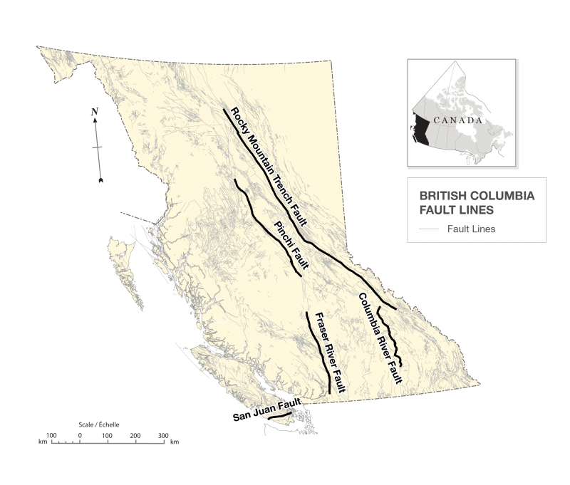
The East African Rift system
The Afar triple point combines three rifts: the Red Sea, the Gulf of Aden and the East Africa rift. We will start with the latter, as it is the one that grabs most attention.

Gregory rift valley, Kenya. Source: World Atlas
The African rift valley is a sight to behold. I remember driving into the wide rift valley in southern Malawi. The slope was not particularly steep, but it still felt like descending into the depth of the Earth. The last part was cross-country to get to a small village near the Shire river. I was glad not to be the driver!
This was towards the southern end of the rift system. The East Africa Rift is a system rather than a single rift: it is not a single structure but consists of separate pieces, not all well connected. There are four main branches. (I recommend looking at a map of Africa at this point.) The West Arm runs from Kenya to Malawi, west of Lake Victoria. The East Arm runs from Afar through Tanzania, east of Lake Victoria. It (almost) joins up with the West Arm at Mbeya.
There are two less familiar arms, located in the south. The Southeast Arm branches off near Nairobi towards Zanzibar on the coast, and from there southward into the Mozambique Channel. The Indian Ocean Arm runs from the southern border of Tanzania to the Comoros and beyond, and from there southward through Madagascar.
The Kariba rift towards the Okavango may in the future develop into a 5th arm. This is beginning to sound like an elephant in the making!

Source: Michan et al. 2022, Earth-Science Reviews, Volume 231, 104089
The four (or five) arms are in different phases of development. They seem most developed in the north and are still feeling their way forward in the south. This suggests that the Rift system started in the northern half. This brings Afar into the picture. Lava adds to this view. Although all four arms have some volcanic activity, major basaltic flows are only found along the East Arm, in Ethiopia and Kenya. Here is where mantle melt is breaking through. Thus, the East Arm is viewed as the main rift, and the others are side shows. The West Arm (with the main Rift lakes, the Mountains of the Moon, the gorillas and some good-looking volcanoes) may be known as ‘the Rift Valley’, but it is not the main-stay and is not where Africa will break – at least this time.
Volcanic dating shows that the Rift system formed over some 40 million years. The oldest lavas are found in the Turkana region, in southern Ethiopia, and were erupted 40 million years ago. Northern Ethopia was next, at 30 million years ago. Other parts of the East Arm were active by 15 million years ago and by 10 million years ago there was activity along all four arms. The West Arm is therefore younger than the East Arm. Clearly, the Rift system is still developing.
And in spite of its reputation, it has not split the continent yet. There is no sea invading this rift. One day, perhaps.
The Gulf of Aden
The Gulf of Aden is the most developed of the three rifts of the Afar triple point, has widened the furthest and has formed a proper sea. The rifting in the Gulf of Aden started already 40 million years ago, with the formation of a basin from stretched continental crust. Oceanic crust began to form in the basin around 18 million years ago, first at the Sheba ridge in the east and over the next 8 million years progressing westwards. 10 million years ago the rift reached Aden. Here it waited. The basin further along towards Djibouti had already subsided, but not yet split.
The westward extension of the rifting toward Djibouti resumed 2-3 million years ago. It breached the coastal mountains 1 million years ago, forming the Gulf of Tadjoura and splitting the Danakil Block from the Ali-Sabieh Block in the process. It remains a work in progress.
The Red Sea
The Red Sea started its formation later than the others. A series of basins had already existed, but it developed into a rift 24 million years ago when volcanic activity started over a distance of 1700 km. The basins started to rapidly subside, first in some locations, and along the entire Red Sea by 20 million years ago. By that time, the Red Sea had formed.
Over time, a small oceanic spreading centre formed in the central Red Sea but it did not progress. Only in the last million years or so has the rifting moved into the Danakil Depression, taking a detour from the straight line through the Bab-el-Mandeb Strait. This is also about the time when the Gulf of Tadjoura formed, working to complete the Afar bypass.

‘Where shall we three meet again’?
The old volcanics
Afar is known for its volcanic activity, both present and past. The three rifts themselves ranged from hyperactivity along the African rift to little along the Gulf of Aden. Africa had been volcanically quiet for a long time, in fact ever since Gondwana broke up. After a volcanic sleep of almost 100 million years, a careless prince wandered in and volcanic episodes began. This started in northeast Africa, but not (at first) in Afar.
First stirrings

The lavas from the Amaro/Gamo event. Source: Tyrone Rooney, Lithos, 286, 264
Volcanic activity along the East African Rift system started near Turkana, in southern Ethiopia and northern Kenya, where lava began to flood the region. This was 45 million years ago and lasted for 10 million years.; it can be viewed as a ‘minor flood basalt’. It is called the Amaro and the Gamo basalts, where the latter name is assigned to the later phases of this long volcanic episode. The total volume is 30,000 km3. A tuff layer dated to 39.6 million years ago show evidence for an explosive event.

Lake Turkana, Kenya

The rifting in Africa thus started not at the triple point, but south of Afar, in the middle of the East Arm.
The next event was far more dramatic.
The Afar flood basalt
30.5 million years ago, a true flood basalt started in central and northern Ethiopia. It continued for a million years, brief compared to the previous or following events. It is called the Ethiopia-Yemen Continental Flood Basalt (not a name that rolls off the tongue – Afar flood basalt is a lot easier to remember) and is typically attributed to a hot spot. A total of 350,000 km3 of lava was erupted, ten times that of the previous eruptions (which also had lasted ten times as long). To put it in context, this is about twice the volume of the Columbia flood basalt but less than a third of the Deccan flood basalt. Lavas from this episode are found in Ethiopia, Eritrea and Yemen, and extend south as far as Turkana. It is mostly absent from the Somalian plateau.
Near the end of the flood basalt phase, a very large shield volcano formed on top of the erupted basalt. It is called the Simien shield, with a centre in Ethiopia some 200 km northwest of Afar. The volcano formed when the magma supply was decreasing and the eruption began to focus on a smaller central region.

The Simien mountains and a tourist (a gelada baboon) in need of a haircut
In its final phase, the flood basalt gave way to silicic eruptions producing large ignimbrites. 29 million years ago, activity largely ceased. For the next several million years there were only a few eruptions across the region.
Wake-up call
This volcanic sleep ended 24 million years ago with a new phase of volcanism. It occurred over a large region along the Red Sea, Ethiopia and as far as Turkana. Different from previous events, this phase formed distinct volcanoes. In Ethiopia, the new volcanoes formed on top of the large Simien shield. They are enormous in size. The highest point in Ethiopia, Ras Dashan (4500 m) on the Simien shield, is one of these volcanoes. Choke also rises to over 4 km and is 100 km across. The lavas are basaltic, with a thin pyroclastic cover. Being so old, these mountains are now deeply eroded. The lavas from this time are also found on the Somali plateau, but here it erupted along fissures rather than individual volcanoes. The Somalian fissure flows were low viscosity and went far into Ogaden, the low land to the east.
The new phase of volcanism differs from the earlier flood basalt. The eruptions were smaller but extended over a large region. The phase also lasted much longer, for some 4 million years. This indicates that this phase has related to tectonic motions and stresses, rather than a singular hot spot.
The activity extended well beyond the earlier flood basalt. There were eruptions along a long stretch on the Arabian side of the Red Sea, although not on the Yemen plateau. To the south, there were eruptions in the Turkana basin. By 20 milllion years ago the entire East arm of the African rift was participating . However, there is no record of volcanism along the Gulf of Aden. After 20 million years ago, activity moved south into Kenya but declined elsewhere.
Remains of this volcanic activity can be seen around the Afar Triangle itself. The escarpments and the Danakil Alps show the dikes left by this phase.
Younger activity
A longer period of semi-quiescence followed, with some volcanic eruptions but no large basaltic flows. This changed 12 million years when again basalt began to flood the land along the East Arm of the African rift. The event started out (again) at Turkana but extended from there both south and north. By 11 million years ago it arrived at the southern point of Afar. This was the first time the Ethiopian Rift reached Afar.

The flows of 12-9 million years ago in the Ethiopia region are indicated in blue. Source: Tooney 2020, Lithos Volume 360, 105291
Some of the flows near Medina on the Red Sea date to this time.
The final (and last?) volcanic phase in the Afar Triangle started around 4 million years ago; it lasted until 0.5-1 million years ago. For the first time, this focussed on the interior of the Triangle. It was another minor flood basalt, called the Afar Stratoid series. (‘Stratoid’ is a word used for flood basalt.) This outburst covered 55,000 km2 of the central and southern Triangle to a depth of up to 1500 meters. The lava flowed from fissures along the general direction of the rifts, parallel to the Ethiopian rift or parallel to the Red Sea.
Basaltic activity subsided again after 0.5 million years ago. The volcanics here seems to go in phases, with a period of basaltic flows followed by shield building and silicic volcanics, after which the cycle begins again.

Volcanic activity along the different parts of the African rift system, showing the start at Turkana Tyrone Rooney, Lithos, 286, 264 (2017)
Rifting
.
In this region, basaltic activity often coincides with rifting. We can try to piece together the formation of Afar and its three rifts from this volcanic history.
We have seen that the East African Rift system has been 40 million year in the making. It began not at the current triple point in Afar, but at Turkana, much further south. The Gulf of Aden also first formed far from Afar, 40 million years ago, and expanded towards it.
The rifting activity accelerated 24 million years ago. The Red Sea flared up along its entire length: it became a proper rift at this time. The African rift activated and extended northward but was slow to progress. The southern part existed by 18 million years ago, but the Afar Triangle was reached only 11 million years ago. Only in recent years (geologically speaking) did the African rift organise itself towards splitting an entire continent.
The fact that Ethiopia and Yemen both show the outpourings of the flood basalt of 30 million year ago, but the plateau in Yemen lacks the 24 million year event suggests that their split happened in between these times. In fact, the Yemen plateau shows no volcanic activity after 26 million years ago. The coastal region shows volcanic activity continuing until 20 million years ago, and erosion sediment indicates that the coast was subsiding. Thus, it is reasonable to assume that the Yemen split occurred 26 million years ago, and it drifted away over the period between 26 and 20 million years ago.
When did the Danakil Alps separate from the Ethiopian Plateau? There are similar granite intrusions in both dated to 20 million years ago, so at that time the two were close together. This intrusion was likely related to the rifting. One possibility is that the Danakil Alps separated at the same time as Yemen, as two parallel rifts. At first, the spreading was mainly accommodated by the eastern side (the Strait) and later mainly by the western one (the Danakil depression). The split may also have happened 20 million years ago.
Either way, this occurred long before the arrival of the Ethiopian rift. Thus, Afar first formed as part of the Red Sea, some 6 million years after the big flood basalt. The subsiding basin of the Gulf of Aden may have arrived around the same time or later, and the East Africa Rift joined up much later, 11 million years ago. Oceanic rifting reached the region only in the last few million years. Tectonics takes time.
The most recent volcanic outpouring, starting 4 million years ago, took place inside the Afar depression. This stratoid series was probably also related to renewed rifting, when Afar began to transition toward oceanic spreading. This was when the Gulf of Aden and the Red Sea spreading centres approached and moved into the region. The effect of spreading was also seen in the Bab-al-Mandab’s Strait, which dropped below sea level at this time, with the Red Sea now filling with water from the Indian Ocean. (Before this time, it received water at its northern end from the Neothethys.)

The Bab-al-Mandab’s Strait
That leaves a question: why did the spreading centres not move into and through the Bab-el-Mandeb Strait? The Strait widened and deepened enough to become submerged, but the rifting from both sides turned away from it to enter Afar itself. A possibility lies in the basalt intrusions. Much of the magma never reached the surface but formed intrusions in the crust. While the crust stretched and thinned, the magma from below was thickening and strengthening it again. The density of the crust in the Strait can indeed be fitted as thinned continental crust with a large injection of basaltic magma. In the end, the crust here may just have become stronger than that in the Afar triangle. But it is also possible that when the Ethiopian Rift reached Afar 11 million years ago, it also split the Danakil Block from the Ali-Sabieh Block. In that case, the rift of the Gulf of Aden found a ready-made gap which provided a more attractive route than the Bab-el-Mandeb Strait.
The flood basalt and the split


Reconstruction of the Arabian plate evolution, by Bosworth et al., Journal of African Earth Sciences 43 (2005) 334–378: The Red Sea and Gulf of Aden Basins. The final panel shows the expected layout 10 million years from now. This is subject to change!
Perhaps surprisingly, the Afar flood basalt 30 million years did not play a major role in this. There is no evidence for strong rifting at this time.
In fact that makes sense. Flood basalts may happen every 15 million years or so on average. It is not something to expect to happen soon (neither do we know what signs would herald one), but they have happened many times in many places. Most flood basalts did not break up plates – it is not a standard part of the procedure. There were large flood basalts in various places during the break-up of Gondwana so there can be a relation. But most commonly there isn’t. The Columbia flood basalt didn’t break America. The Deccan traps and the Siberian traps didn’t break India and Siberia. Why would Afar have been different?
It is not easy to split a plate. It takes more than a push from below. It needs a pull as well. That pull needs to come from existing plate movements, such as a subduction zone pulling a plate towards it, as happens in the Pacific ocean. During the break-up of Gondwana, there was plenty of pull. Africa is more stable.
In Africa, the pull in the east-west direction is distinctly lacking. But there was a pull towards the north, where the final generation of the Tethys ocean was disappearing underneath Asia. This pull only ceased 10 million years ago when the collision was complete. And to the east, India continued to move north into Asia, in a collision that was already in slow-motion progress. The India plate was separated from Africa by a fracture zone in the Indian ocean, but this was a sticky zone and India was doing its best to pull Africa along. So Africa was under some north-south stress. The stress had create a number of basins, where the crust had stretched and weakened. Both the regions of the Red Sea and the Gulf of Aden already contained such basins, 60-80 km wide.
So the rifting had started before the Afar flood basalt. It developed in the general direction of the Afar flood basalt (which was actually centred south of Afar), but took a very long time to get there and arrived long after the time of the flood basalt. In the process it managed to form a decent width of oceanic crust. The fact that in the Gulf of Aden the rifting progressed east to west shows that the pulling factor came from the Indian ocean. India pulled the zipper.
The Afar plume hit south of a region where the crust was already being stretched and weakened. It helped it along: it melted and thinned the lithosphere and heated the bottom of the crust, creating a focal point for the stress to focus on. It pushed Africa over the edge. But not immediately. It took 6 million years for the Red Sea-Gulf of Aden rift to develop. The Ethiopian rift did not arrive until much later. The flood basalt did not form a triple point. That came much later.
Afar and away
Let’s go back to the Afar triangle itself. The triangle is in effect the region between the escarpments of the Ethiopian and Somalian plateaus, and the microcontinent of the Danakil Alps / Ali-Sabieh Block. On the other side of this block, the Bab-el-Mandeb Strait separates it from Yemen plateau. The Afar Triangle can be viewed as a by-pass, a road around the Bab-el-Mandeb Strait.
When Yemen rifted from the Ethiopian plateau perhaps 26 million years ago, it drifted north, and the subsiding crust formed the Bab-el-Mandeb Strait . This provided a seaway connection to the developing Red Sea. The Danakil Alps / Ali-Sabieh Block remained close to Africa. But then this microcontinent started to move. In the north the Danakil Alps remained pinned to the African plate, but in the south, it was pinned to the Arabian plate. Under the pull, the new microcontinent began to rotate anti-clockwise. This rotation expanded the Afar depression and is one reason for its triangular shape. The rotation has now reached 23 degrees. Much of this happened in the past 5 million years: this rotation is related to the Afar stratoid basalt flows.
(The existence of the microcontinent is not universally accepted. It is also viewed as part of the Arabian plate, just on the wrong side of the Strait.)
Where does this leave the famous triple point? The location at the southwestern tip of the depression was never it. This is where the microcontinent split off. The connection with Yemen was on the other side of that block. But a triple point could not have formed until the East African rift arrived, which was much later. Even now, the three rifts haven’t fully formed yet and it is hard to point out a precise place where they meet. Perhaps there is no such thing as the ‘Afar triple point’: it is a region, and has not yet become a point. Perhaps it is pointless.

Rise and fall
The change in elevation between the Ethiopian plateau and the Afar depression, between close to 2000 meters to near sea level is extreme. It is also recent. Originally, the plateau was much lower and the depression less depressed, with a much smaller step change between. What happened?
We should first note that the high plateau is not in itself caused by the deep flood basalt of 30 million year ago. Basalt is heavy, only a little less than the mantle below, and the weight would have depressed the region by about its own thickness. In any case, the flood basalt does not cover the entire plateau. To support the 1000-km wide plateau requires support from below, either in the form of heat (making the mantle less dense) or upward convection (pushing the crust up). This is part of the evidence for a mantle plume, which would have provided both the flood basalt and the uplift. A mantle plume head also has about the right size. But this was 30 million years ago. Why is this region still so high?
It turns out, it wasn’t. Up to some 5 million years ago, the plateau was no more than 1000 meters high. The further rise of the plateau to the current height happened after that. It is not fully known what caused it. A new pulse of heat may have reached the region. Was this a new plume, providing the push, the enhanced spreading and the stratoid basalt? Models are not in agreement on this.
Incursions
Currently the Afar Triangle is dry, even where it is below sea level. That has not always been the case. The Danakil Depression is deeply covered in salt (mixed with a fair amount of volcanic ash). It shows that this depression was once connect to the Red Sea. At times this connection to the Red Sea became closed off, and the sea arm would evaporate, leaving the salt behind. This may have happened several times over the past 200,000 years, the last time 30,000 years ago. Scattered around the region is fossil coral, left behind from the time this was an open sea arm.

Fossil coral in the Afar depression
There are also remnants of evaporated saline lakes, but these are much smaller than the massive deposits of the time when this was sea.
Lake Assal has also been connected to the Gulf of Tadjoura in the relative recent past. This connection was closed off by the growth of the intervening volcanic range.
Oceans past and future
There are many articles in various newspapers and websites that talk about a ‘new ocean’ forming. The depressions and cracks which these articles point to are along the Danakil depression. But this is not a ‘new’ ocean but is a completion of the Red Sea. And the Ethiopian rift is nowhere near forming an ocean. So those reports should be taken with a grain of salt.
But all across the regions are the signs of submersion, from the extensive salt layers to ancient volcanoes with submarine shape. How is that reconciled with on-going subsidence? There is uplift in regions which interferes with the inflow of water, as it does at the moment at the end of the bay of Djibouti. It is not a one-way route towards a sea. The water comes and goes as the land rises and falls.
Play of plumes
A topographic map of Africa immediately draws the eye to Ethiopia and its high plateau. It sticks out like a sore thumb. It looks like the elephant in the room.
To create high altitude plateaus in the absence of continental collisions requires a push from below. A plume is often assumed. Plumes have limited size, but a large plume can create a plume head 1000 km across. Mantle plumes are expected to cause large basaltic eruptions, while their heat causes the land to rise over the size of the plume head. This fits Ethiopia and Kenya, both of which show such eruptions and a size of the bulge of around 1000 km, as expected for a plume head. The mafic flood basalt and the size and shape of the Ethiopian rise fit the expectations well. The ‘Afar plume’ is among the best established ones in the world. That was 30 million years ago. Africa is slow moving, and the plume could not leave a trail like Yellowstone or Hawai’i. The fact that the rise still exists suggests that the plume still lingers as well.
But is it not the only such plateau in Africa. There is a second one: the area in between the two arms of the African rift. It covers Kenya and Tanzania with Lake Victoria at its centre. The edges of the plateau show mountain ranges, among them the Mountains of the Moon. A low corridor exists between the Kenyan and Ethiopian plateaus: they appear to be separate structures. Since the two plateaus are separate, does this require two plumes? It is commonly interpreted as such. The lava compositions show that both regions are fed from the mantle, with Afar having a deeper source than Kenya. So one is considered a deep plume and the other a shallow one.

Much of the southern third of Africa also has a high altitude, peaking at the Drakensberg. This large rise (a ‘swell’) even extends into the nearby Atlantic ocean. This swell connects to the Kenyan plateau but appears to be a separate structure. Unlike the other two rises, it is also entirely non-volcanic. The rise of Southern Africa extends over a much larger region than the other two, larger that expected for a plume head. That is no problem for the geologist: to explain such a region (a super-swell, as it is often called, where presumably a ‘swell’ is limited to the size of a plume) must obviously require a super-plume. So now we need two plumes and one super-plume. We are looking for a plurality of plumes.
(The elephant analogy would suggest four plumes, as an elephant has five arms and four stomach chambers.)
A name is needed. What is an appropriate collective noun for plumes? Sheep come in flocks, bananas in bunches, girls and ladies in gaggles (I am not making this up) but if they are movie stars they bunch up in galaxies, rioters form mobs (soon to be known as Muskies), lions form prides, owls make a parliament (thank C.S. Lewis for that one). So how about plumes? If strict alliteration is required, then ‘play of plumes’ or ‘plume plethora’ will do. People who fight for plumes (the PLF or Plume Liberation Front comes to mind) may prefer ‘exuberance of plumes’. Plume opponents (the WOPS or ‘War on Plumes’ party) may prefer ‘plume extravaganza’ or ‘indulgence of plumes’. Neutrals could pick the boring ‘plenty of plumes’. Pick your choice – or suggest a better one.
Afar is the poster child for mantle plumes, flood basalts and continental break-up. It makes a strong case and a good story. But sometimes a story is too good. This plume did not break up the continent. It just helped things along that were already happening. And the story is incomplete. One plume can not explain the rifting of all of east Africa. Multiple plumes will help but where do several plumes in short succession come from? And what is a ‘super plume’?
Deep underneath southern Africa lies a peculiar region. The LLSVP (large low shear seismic velocity province) is often blamed for the superswell, and sometimes an LLSVP is even equated with a superplume. (If you do not know what an LLSVP is, you may want to read The Living Earth.) But the LLSVP is located 1500 km deep, and although warm, it is neither rising nor a plume. Can it explain the superswell in Southern Africa and could it trigger the other, smaller plumes? We don’t know.
Being a poster child is not easy. It hides complexity: real people are always so much more than the poster. Afar has everything. But it is neither the end nor the beginning. It is itself, a region of fascination where we can see tectonics in action.
Albert, January 2025

Rifting and subsidence in Afar. Source: Columbia University https://news.climate.columbia.edu/2013/07/08/in-the-ethiopian-desert-a-window-into-the-rifting-of-africa/
Further reading
https://www.volcanocafe.org/volcanoes-of-saudi-arabia/
https://www.youtube.com/watch?v=E8ltsv-Jmew
https://www.youtube.com/watch?v=LZc1bf8R3fw
https://www.nature.com/articles/39853
Conti et al 2015, Rift-Related Morphology of the Afar Depression https://flore.unifi.it/bitstream/2158/1136615/1/Corti_2015_springer_book.pdf


Bravissimo, Albert! I was looking forward to this post. Feedback coming as soon as I’ll have finished reading!
Thank you RenatoRio
Africa is the hardest continent! Hard to understand, and hard to break up. Sorry for the long post and I hope it makes some sense of what is going on. Any misunderstandings are purely mine. There may be another post on volcanoes of Afar – I’ll see.
wow thanks Albert.
“Everything you wanted to know about the African rift system but was afraid to ask”
Superb, taken me a few days to get to grips with your amount of detailed information and research!
I think I’ve got it now….ish!,
Fantastic
Many thanks
Great post, Albert.
Flying in to Nairobi, the evidence of rifting is stunning.
Regarding the post, the missing elephant in the room is Kilimanjaro. Is it at all related to the moving plates?
That looks like another post..
Excelent, mind-blowing post!!!
Where else would mankind arise other than amidst this plethora of plumes ? No wonder humans are such complicated beasts!
Craving for more here! I would love to understand the connections with all the weird volcanoes that thrive in this region, such as Oldonyo Lengai, Nyiarongo, etc. And could never have imagined that you would stretch as down south as Drakensberg – thought it was a way older continental feature.
And I have a question: I remeber Carl mentioning once that Mount Cameroon was supposedly a child of yet another mantle plume, is that so?
Thank you very much indeed! Food for thought!
Mount Cameroon would definitely need a track inside contnental Africa which is possible, but hard to find and prove.
Alternative:
“Two giant blobs in Earth’s mantle might explain Aftica’s Weird geology”,
(LLSVP=Low Shear Wave Velocity Provinces),
Stephanie Pappas, LiveScience
If Mount Cameroon was sitting above a mantle plume it would have to have a trail to the area of Tibest/Northern Chad, which is not entirely impossible.
There’s more to it though. There is the Central African Shear Zone (CASZ) running from Cameroon to the Red Sea north of Eritrea and the West an Central African Rift System (WCARS).
Wow! How do you do it? This has been an excellent series on a region I know (or knew, til recently) next to nothing about. I really enjoy learning HOW the rocks and strata are analyzed to find out what happened and in what order.
Also regarding the name for a collective of plumes, I recommend “a parrot”… as in “beeeyoooteeful plumage”. The parrot of plumes beneath Africa must’ve had many a long squawk.
This is long and detailed, so I have to read it twice or more. It is excellent.
At the beginning you write hosts or hosted a plume. I believe some thought should be given to the idea that Africa once before it got stuck NNE, might have travelled faster. Considering the Indian speed there is a chance.
Getting back to the past tense of hosted the q arises whether the big mass of Nyaragongo and its siblings could now sit right on the plume.
I remember Jesper once pondering this.
To spare you work, Djibouti-Goma 2.130 km as the crow flies, the idea only survives with a larger speed 40 Ma +
You will know whether there are flood basalts in or near Rwenzori Mountains.
Nyiragongo and Nyiramuragira is at the western rifts of what I calls
the ”victoria plume” the swelling continental boulge that encases both Tanazia, Uganda and Lake Victoria that swell boulge is 1500 kilometers maybe 1800 kilometers wide, in USA the litosphere dome woud stretch from Seattle almost all way down to San Diego.. this place in Africa coud be the locale of the next LIP scale flood basalt and maybe Nyiramuragira coud be the embryo of something to come..
In the mean time we will have to be content with Kilauea by far the worlds most productive and powerful individual volcano, If pressure is not relived that much in Halemaumau we will end up with Kilauea iki sized fountains, but it coud soon get too open for that as well as the conduit erodes and gets bigger
Thank you Albert, fantastic article.
What is the idea for movement of Arabian plate? I thought the major mover in tectonics is a pull of subducting slab. So closing of Neotethys creates subducting slab which then pulls yet another “ribbon” continent?
Yes, it was pulled in by this subduction. There is also Turkye’s westward movement. It is all related
https://www.facebook.com/share/p/1A2VRgo9vJ/

It is confirmed (maybe), Fentale volcano has been gassing a bit…
Theres been 2 dikes in the area in a few months, seems likely to be an actual rifting event. That is making subsidence in the caldera which might become visible in the topography with time. If theres any shallow magma there it will probably start leaking out this year some point. Thats my guess, such a major rift is very unlikely to not involve some eruption at some point. 90% of magma staying in the crust isnt the same as 9/10 intrusions fail, which us what usually gets repeated. Most if not nearly all big intrusions do erupt somewhere.
It’s somewhat reminiscent of a ring fault or ring dike. Maybe Fentale collapses and pulls off an Askja 1875-like eruption. Or perhaps it does nothing, idk.
Maars on Mars.
Kitchen experiments shed light on Mars’s volcanic rootless cones (Phys.org, 27 Jan)
The Martian maars will have all dried out by now, but it seems there was a lot of phreatomagmatic stuff going on earlier.
Does CO2 ice do phreatomagmatic eruptions?
Lots of water on Mars, but at the moment almost all of it is in the ice caps. Back in the early period there was plenty of liquid water to interact with lava.
I have wondered if there might be liquid water under some of the ice.
Kilauea starting back up now 7:18 pm PST see https://www.youtube.com/live/w0KulR_3wQk?si=8Xnv1t4t3DMFY1PR
Yes, spattering and probably an overflow within an hour. Still no tremor or deflation just yet.
I think episode 4 was the point of equilibrium in the magma system. Episodes since have been small and frequent, and have also only occurred after net inflation of about 0.5 microradians on the tiltmeter over the trigger point of the episode before. So basically now Kilauea is inflating again for the next eruption while it is also already erupting… 🙂
This is where it gets interesting, higher pressure, the fountains could start to get bigger.
Seems like the southern vent is getting involved too.
Yes and the fpuntain is throwing a lot of lava up on the wall behind the vents and feeding a rootless spatter flow. The fountain isnt enormous but does seem stronger than last time. I wouldnt be surprised if it is over 100 metets but perspective can fool. Still it seems a safe bet fountains will get bigger if pressure increases.
The tilt is dropping way faster than in earlier episodes, the eruption rate has ramped up.
Yes I was thinking that too, already half way to over if it stops where the last episode did. The fountains are still huge just not as tall now, maybe getting drowned a bit by the lava within the cone, its kind of pulsing as it blows it out and the lava just flows back down the wall into the vent again.
I guess maybe eventually the lava built up on the wall might slide into the vents and fill the crater, preventing a pond forming over the vent. When the crater of Pu’u O’o filled in in mid 1984 the fountains got way taller, no obstruction. But when or if that happens soon now is unknown.
Been only 7 hours and already dropped to the low point of episodes 5-6. No sign of gradual decline so its either ggot a lot more dropping to do or its going to stop very suddenly in the next hour.
I havent seen any eruption rate ever posted for this eruption yet, but E7 is so far about 3x the rate of the last 2 and probably the highest since the first few hours of the eruption. Its looking very plausible that fountains get higher than the rim at some point soon at this rate. Even now its having pulses that get close to the top of the live view.
The fountains are 100-120 feet = ~30-40m high. If we add this height to the present caldera floor level of ~945m, we get a height of ~980m. This is probably the upper limit until which the lava field/lake can grow.
A different topic: I’ve recently noticed many earthquakes along the cliff S of Mauna Ulu. Are they tectonic because of the moving flank, or are they magmatic?
The top of the fountains isnt as important as the elevation of the vent in that regard. That is probably around 950-960 meters for the north vent, a little less for the south but they are both higher than the crater floor.
But keep in mind that most of the lava for over a week now has actually not really flowed over the old 2020-2022 vent that the laser points at, so it is underestimating. It has done so overnight and lifted it up to 950m already, this alone might actually make all of these other numbers unreliable until they move the laser to point at the vents now or directly state the vent elevation somewhere.
Also the south flank quakes are tectonic because there isnt magma directly causing them, its tension and compression stresses like a plate boundary quake. But yes uts kind of a grey area in terms of technical classification.
Im also not sure this particular part of the south flank actually means much for ERZ magma pressure, that seems to be more related to quakes seaward of Pu’u O’o and near Kalapana, more than in the Hilina Pali area. Its kind of more the latter right now, pressure from the summit it I would guess.
An unusually sharp picture from the M2 cam, usually it is a bit overexposed.
https://i.imgur.com/dTOiLqR.jpeg

Very beautyful during the Mauna Loa 2022 show it looked like a thermite reaction 🙂 due to expousre
Theres a pretty big cone building around the vents, probably about 40 meters tall now. The north vent is also clearly elevated above the crarer floor now too, its building up quickly. The southwest bay of Halemaumau is certainly going to look unrecognisable by 2026.
A lot of rootless flows in this particular episode.
Very fun indeed when supply is near record high as it is now, I dont think even “supervolcano” or even “hypervolcano” is able to even describe Kilauea compared to most other volcanic edfiices, Kilauea is an an absolute beast whos submarine massif can swallow some small countries on Earth..and its direct magma supply is equal to many 100 s of other sleepy volcanoes at once which is rather fascinating…. Kilauea is providing us with our dreams: lots of lava to see nearly daily at high output
Ots a sypervolcano in the long term productivity. But its individual eruptions are pretty normal sized just frequent. A basaltic supervolcano is what creates traps formations. Hawaii probably cant become that, but Iceland possibly could turn into one, lots of oceanic plateau LIPs have complex history involving flood volcanism but also normal scale stuff, Iceland is just one of those thats still actively forming. If the plume ever becomed detached from the boundary or gets more active, magma can accumulate. Maybe the descendent of Hofsjokull will be a real heavy hitter.
But after seeing the elevation of the Victoria craton in the article I am betting the next flood basalt volcano will be on the side of it and reasonably soon. If they average around every 15 million years worldwide then its right about on time too. Possibly on both sides even, although the west side seems likely sooner with how active the Virunga province is.
Yes I knows that Hawaii is Not a VEI 8 basalt traps volcano, but the hawaiian shields are simply massive anyway as shield edifices as long term growth as result of their high magma supplies, really large older individual Hawaiian shield edifices can grow as large as the entire CRFB province in one single shield! .. but as you say its frequent eruptions that piles up but of a quite normal size compared to huge VEI8 traps lava flows
How large will the flood basalt be when Africa goes crazy? the Victoria mantle boulge is quite sizable indeed in this map and its a feature that appeared in the middle- late cenozoic, coud the next African LIP be larger than the CRFB? that where in reality a small one.. I guess Nyiramuragira and Nyiragongo coud turn into a rather scary volcanoes in the future.. their isotopes like Hawaii also comes from very deeply down
Columbia River flood basalts were relatively small in volume but the eruptions individually were not, some were multiple thousands of km3 erupted in under a year and maybe much faster than that. Just that eruptions that big were pretty rare probably millennia to even 10s of nillennia apart. Although, its very likely there were a lot of smaller and normal sized eruptions too perhaps like there is today in the SRP. As well as the silicic calderas at the start of the Yellowstone trail.
I could see something like this happening along both sides of the Victoria craton, maybe not at the same time though. But it looks exactly the sort of situation that large scale basaltic volcanism happens.
Iceland as you say is likey to top of another developing major LIP here is a elevation map of the whole atlantic but its likey old data and maybe incorrect.. and map is extreme exaggeration to show the elevation
2 microradians of tilt already, in only 15 hours. If the tilt needs to recover back to the point that episode 7 started then episode 8 could start in 3-4 days, on Friday or Saturday local time. But if it is going to go after the same recovery as the last few episode then its going to be ready tomorrow 🙂
Im leaning to later this week or on the weekend still.
I am wondering – Albert – whether you really meant the Okavango when you wrote about the fifth arm.
I was wondering whether you were rather thinking about the Zambezi. Both rivers originate in Angola, the Oc. In the west, the Zamb. In the east. The Zambezi then turns east though and has its mouth in Mozambique whereas the Okavango teters out in its inland delta in Botswana.
If not I do not understand the passage about the fifth arm.
You can see it on the map of the rift system in the post. In the left image it is designated as the Kariba rift. In the right image you can see it lines up with the Okavango rift. It is located within a basin called the Makgadikgadi-Okavango-Zambezi basin. So both rivers follow it for a while, in opposite directions. In the future, the Okavango river may change direction if the rift continues to develop.
Thank you. Interesting.
Interesting:
David Hilton, geochemist, specialized on stable isotope geochemistry and volcanology, (unfortunately late – died at the age of 59, obituary on site UC San Diego) on his analyses of Helium and Neon isotopes from the African Rift and the possibility of a superplume under the length of the rift, eastern branch. From 2014, but fresh and in no way outdated, above all very well presented:
Rift! Geologic clues to what’s tearing Africa apart
Youtube
Would have loved to have such a chemistry teacher 🥲
This series is fascinating and I’m learning a lot – thanks for writing and posting it!
Thanks for episode 2 on Afar Triangle, Albert!
I’ve thought about whether divergent plate boundaries and rifting usually is combined with a hotspot. All in all a divergent plate boundary runs a bit similar to a plume. The break-up of continents may work with a combined force of plate and plume dynamic.
The south end of the East Branch in Kenya indicates to me that the rift won’t succeed to make an ocean, but in best outcome a new sea arm towards the south that looks like Red Sea. The Ethiopian-Yemen Plateau looks like a typical horst structure that happens often on the sides of a rift. The present Scotish and Scandinavian mountains developed like this, when the Atlantic rift(s) happened. Here the uplift presents the Caledonian structure again that otherwise would have been buried below an even landscape.
Hot spots and plumes are not necessarily the same thing. A hot spot may have other causes. In a rift, mantle material will naturally come up and create a temperature excess. No plume is required for this, and it is driven by the rifting. A plume comes from below and is driven by a larger temperature difference between the bottom and top. It is driven either by deep heat, or by a colder than usual top.
The presence of horst structures has been suggested along the oceanic rifts. They can be quite high, but the entire Ethiopian Plateau is much too large and is not centred on the rift, and the Yemen plateau is nowhere near the rift. It can be a contributing factor but probably no more than that.
It should also be added that the Caledonian Orogeny is older than the Atlantic Ocean and resulted from collision it is thought, not from rifting.
Subduction might have been involved as the Iapetus Ocean closed.
Reykjanes has been shaking a bit today, as has Ljosufjoll. Bardabunga also had another star in the last couple of days.
The columnar basalt in Turkana reminds me of the similar structure in New Jersey, Palisades Sill. The latter is 200 million y old. That was when rifting started there, Morocco being seperated and the Atlantic Ocean forming.
Fingal’s Cave and the Giant’s Causeway might also have to do with rifting.
“There is no seawater invading the rift. One day perhaps.”
The seawater levels are too low in comparison to much of Earth’s history.
Apologies to New York City and Miami.
It might have been better to have the Geology knowledge first and the building later.
What a fascinating and detailed article. Thank you!
I propose that a multiple of plumes simply be called a plumage.
good one!
The Victoria sponge (Sorry, microplate) contains some of the youngest, if not the youngest kimberlite eruptions on earth at the Igwisi Hills complex, approx. 10,000 years old. I do wonder if this is related to a mantle plume as it requires immense pressure from deep in the mantle to push these kind of eruptions out, usually through ancient cratons, and they are ultramafic like some of the magma near Ol Doinyo Lengai in the East African Rift.
Other kimberlites found in South Africa, the Congo etc. seem to be associated with continental rifting and/or mantle plumes.
And there are also Kimberlites in New York State, rifting ~200 Ma. And there is the North America mid-cretacious Kimberlite Corridor from the Canadian Arctic to Kansas passing Saskatchewan. That was the location of the Western Interior Seaway which closed later. Also found in the surroundings of the St Lawrence River..
I cant remember where but I read somewhere the Igwisi Hills kimberlite might be of different origin to the diamond bearing magma. It wasnt a violent plinian eruption but more like explosive strombolian or subplinian, with effusive stage that I have seen interpreted as either a pancake dome or a perched lava pond with limited overflows. Im more inclined to the second, its hard to see how a magma with very little polymerizing elemebts can become viscous, even wet sand (crystals in a melt 🙂 ) can be very fluid. I think the Igwisi magma was fractioned from carbonatite or something like that, really weird chemistry. Someone else might have the paper.
Maybe this is only known in these particular volcanoes because older examples this small would weather away completely. There might be older but still recent kimberlite vents nearby but not obvious. Or it really is the first in this area for a very long time but kimberlites often occur in clusters so more might be likely in the future.
One not on the map is the Copeton/Bingara diamond province. Near the east coast of Australia a couple hundred km inland from Newcastle, where I live.
Once we were fossicking near Bingara and I found a perfect octahedral diamond, only a few mm in size, and black. So not worth anything. But it was nice proof in my hand that the diamonds were there.
We mostly were looking for sapphires, which are abundant in that area too.
One of the interesting thing about Copeton diamonds is they are the hardest natural diamonds on Earth, due to nitrogen inclusions. I don’t know the source magma: indeed there’s been a controversy for a long time about exactly what eruption they came from. No one has found it. They are fairly young too, from the Carboniferous – which makes them a lot younger than any of the cratons on the diagram.
Some nice details about these diamonds in the following paper from 2008:
Ultrahigh pressure macro diamonds from Copeton (New South Wales, Australia), based on Raman spectroscopy of inclusions
Florida is no longer phrozen.
https://m.youtube.com/shorts/q8vhxfm7pWk
OT: If you know your volcanic islands you can take part in NASA’s puzzler competition.
The January puzzler shows a volcanic island with a crater lake, red cliffs, and a small central cone:
https://earthobservatory.nasa.gov/blogs/earthmatters/2025/01/28/january-puzzler-10/
I admit, I’m drawing a blank here…
I know where that is!
Free clue; it’s been in the news, in a small way, in the last few weeks… a mystery solved…
Excellent, you are right of course! Go for it and claim the glory of having solved the puzzle.
I’m not going to steal the fruit of your insights…
I’d look at the neighbours as well. The one in the news has a row of five stratoes. There is ine next to it with two volcanoes and one with high cliffs and one single volcano with a crater lake. I would rather think of the latter.
VEI 9.
Juno mission spots most powerful volcanic activity on Io to date (Phys.org, 28 Jan)
Wow, I guess it must be a lava lake. But bigger than Lake Superior? Yikes. If Elon succeeds with his big rocket somehow I doubt Io will ever be a guided volcano tour destination.
This is ridiculous but some officials from our current administration is considering stopping the culling of birds infected with H5N1.
Tallis:
“This is ridiculous but some officials from our current administration is considering stopping the culling of birds infected with H5N1.”
Damn thing mutates real fast. Will be the next human pandemic. Vaxx only for the lucky (wealthy) few. 😠 😡
https://www.nasa.gov/solar-system/nasa-juno-mission-spots-most-powerful-volcanic-activity-on-io-to-date/?fbclid=IwZXh0bgNhZW0CMTEAAR0O1Ovf7Mj_2kj_STRptMiaWf96NEBWokQBaWeK3BjgHffJrWRKhI8uL6s_aem_Rv5Qcc5pWFUqVBK0lS_XDQ
More mega eruptions spotted on Io
Albert, an idea, wondering what you think about it.
Deducting from late David Hilton’s idea of a superplume under the African Rift east and from your thought that a (an ancient?) plume head might reach a size of 1000 km I suggest such a superplume (which cannot be proved as it would be gone) under – clockwise – Nevada, Oregon, Idaho, Wyoming west, Utah, back to Nevada for 30 million years, emptying out its material nearly completely feeding:
1. Wah-Wah-Springs, Lund Tuff, La Garita
2. The Columbia River Basalt
3. Long Valley and Yellowstone twice plus the Snake River Plain and Columbia again.
Points against: Not visible in tomography. Explanation: a) never there, b) emptied out nearly completely, points for.
Why there? Big masses lead to mantle upwelling. There might have been a week spot. A lot of mountain building and uplifting led to also considerable extension. And 60 Ma before that there had still been an ocean in place there.
Just an idea, which cannot really be proved. But volcanism over a period of 30 million years with that huge amount of material all around the west could empty out such a reservoir, helped of course by the subduction of the spreading ridge of the Farallon Plate and uplift.
Rests of hot material would dwell under Yellowstone, maybe also under Long Valley. Both eruptions in both areas around the same time btw. Both have hot springs.
It’s Long Valley that took me there btw, the volcanism at the same time (~) as Yellowstone and without an explanation at hand. What if we are dealing with s.th. That has been and disappeared?
I think Long Valley is actually part of the Walker Lane fault zone – California’s answer to breaking away if San Andreas fails.

I think these articles from another blogsite will sum it up best:
https://volcanohotspot.wordpress.com/2018/09/21/splitting-north-america-the-walker-lane-part-1-the-tectonics/
https://volcanohotspot.wordpress.com/2018/10/12/splitting-north-america-the-walker-lane-part-2-the-volcanic-fields/
About the La Garita and Wah Wah Springs, they are part of an ignimbrite flair-up called the Mid-Tertiary ignimbrite flare.

From: https://cires1.colorado.edu/people/jones.craig/WUStectonics/CzIgnimbrite/INVESTIGATION/SECTION_4/petrology_intro.html
Basically, they are formed via through a series of tears and rollback from the Farallon slab about 36 to 18 mya.
https://www.researchgate.net/publication/303600918_Slab-rollback_ignimbrite_flareups_in_the_southern_Great_Basin_and_other_Cenozoic_American_arcs_A_distinct_style_of_arc_volcanism
And to dare connect Long Valley with La Garita, the Sierra Madre ignimbrites in Mexico happened at the same time and, in the end, the Gulf of California began forming and leading up to the Walker Lane


https://agupubs.onlinelibrary.wiley.com/doi/full/10.1029/2001tc001302
https://www.researchgate.net/publication/356730755_Tectonic_and_petrogenetic_settings_of_the_Eocene_Challis-Kamloops_volcanic_belt_of_western_Canada_and_the_northwestern_United_States

Speaking of rollback, there were earlier Eocene volcanics at Yellowstone but not related.
It is presumed that they stopped one the Farallon began to roll back.
on the Kamloops group volcanics diagram (below) it appears the the location of the fraser fault is misplaced (if i am not mistaken)
Yeah, I think that was supposed to be the Rocky Mountain Trench fault.

From: https://www.researchgate.net/publication/351221557_Structure_and_Dynamics_of_the_Southern_Rocky_Mountain_Trench_near_Valemount_British_Columbia_Inferred_from_Local_Seismicity
It is like San Andreas but slower and is fairly interesting. (I think the dotted line at Pr is the Fraser Fault).
Thank you: As usual, a totally wondrous article…
A plethora of plumes ??
With a nod to Occam’s Razor for invoking excessive complexity…
Though I’m reminded USGS finds Yellowstone has *remarkably* bifurcated ‘root’…
IIRC, the Cameroon volcanoes and their *infamous* gas-spewing lake over-turns are associated with an Atlantic aulacogen. The coastal leg’s inland tip seems to have tried for a mini triple-junction: Bifurcated, one leg trying to go North, towards what was the Tethys, the other East-ish towards the now-Great Rifts…
Presumably, the Cameroon divergence stalled when Africa / Europe stress patterns changed as Iberia rotated out of the way…
Does Basalt have a single melting point or several melting points for different heterogenous components?
In an article (about Basalt as a usable material) there are these opinions for basalt’s melting point: https://www.sciencedirect.com/science/article/abs/pii/S1359836816311039#:~:text=investigated%20the%20chemical%20composition%2C%20viscosity,Pa%20s%20at%20working%20temperatures.
1. “they found a melting temperature range of 1175–1350 °C”
2. ” determined that the melting temperature is above 1450 °C”
3. “Li et al. determined that the highest melting and crystallization temperatures were 1320 and 1270 °C”
4. “they obtained the melting temperature (1291 °C, 1332 °C)”
It also depends on pressure: at greater depth it will melt at higher temperature.
Indeed, I should have simplified it by applying it to standard atmosphere conditions.
Maybe the answer is a bit difficult, because basalt contains many different components with different melting points. Also the ionic bonds probably vary a lot. If we look at one of the most prominent components of Basalt, we get a melting point of 1710°C for Siliciumdioxide (SiO2). But this is the melting point of pure/homogenous SiO2, as we have it f.e. in Quartz. SiO2 rich magmas (Rhyolite) are probably too heterogenous to get the melting point of Siliciumdioxide.
Thank You !!
Though that article is expensively pay-walled, scant Googling found several related ‘open access’ articles / PDFs: Wrangling Mineral wool / Rock-wool is serious stuff…
I’m gathering material for an on-going Sci-Fi tale, as ‘Hard Science’ as I can make it.
‘City of Fresno’, leaving with five thousand ‘Last Train’ evacuees ahead of impending ‘Repeating Nova’ from that system’s nearby ‘Common Motion’ star, is caught by shock’s ‘Einstein focus’, tossed beyond ‘Local Bubble’. Think squeezed pip or surfing tsunami.
Too far from home, after many adventures, they reach a double ‘edge-case’ system with both a ‘Big Mars’ and a ‘Parboiled’. Latter would have gone ‘Full Venus’, but ran out of ocean to boil. The ‘Big Mars’ AKA ‘Ares’ is easy: Sunny side-wall of rift valley, dig adits for pressurised habs, drill to water-table.. Latter planet has a ‘Mons-grade’ volcanic mega-shield AKA ‘Massif’ poking above the clouds like Maunas and Atacama. Black basalt ‘ropey’ lava, a night dew ? Game on !!
😉
Next episode of the Svartsengi fires is getting close says IMO.
Increasing chance of new eruption around Svartsengi (RÚV, 29 Jan)
Not much in the way of tremors in the Reykjanes so the magma must be coming up quietly through the established dikes and sills rather than cracking preexisting rock strata.
Still wet to white winter on the webcams: https://www.youtube.com/watch?v=kXD4A9uFHcg
But time has come to check the webcams regularly.
Iceland’s emergency services are now getting interested.
Increased likelihood of eruption (RÚV, 30 Jan)
Bad weather in Iceland right now so I doubt the webcams will show much.
Also digital monitoring will probably have problems to observe volcanic signals. In worst case we’ll only see a rough glow behind a haze of raindrops on the webcam.
IMO commented on the weather covering up any activity over the weekend, on there Jan 31st update.
Excellent article.
Would a group of plumes be a plumage?
Flood Basalts should have to do with water too. Water is totally neglected although everybody knows that eruptions that have a connection to water are much more powerful.
We have a symbol for that, it can be called iconic: HTHH.
It is obvious that the Turkana-, the Afar-, the CAMP, the NAIP, the Paraná-Etendeka, the Deccan Traps, probably the Siberian Traps, the Caribbean Plateau and e.th. that floats in the PO with Chief 😀 Ontong -Java had to do wirh water.
Contnental flood basalt is more difficult to decipher, but one thing can go for sure. From Salt Lake City down to the Salton Sea there was periodically a lot of salty water in the form of inland seas.
The Preillinoian stage is telling, the marine fossils as well. Preillinoian is the American nomenclature. In GB and also in the Alps the nomenclature is different.
Is anybody working on this? Yes, of course. One of the papers:
“High Water Content in Primitive Continental Flood Basalts”,
Qun-Ke Xia, Yao-Bi, … Han-Lin Chen
Nature dot com
The work is from Tarim LIP, NW China.
Note that intense LIPs / ‘big’ flood basalts on land often come with regional or global ‘extinction events’, while their ‘submerged’ equivalents; volatiles / fall-out get safely diluted…
Pretty interesting, Zach, the Rocky Mountains Trench. It should be divided into two parts though as the northern part including the Tintina Trench is right-lateral strike-slip like the SAF indeed, whereas the southern part is thought to be mainly due to extension.
Accordingly – I had to look it up – there is a list of quakes -6 between Vancouver and Yukon.
I think they are already seperate faults, with the Tintina Fault having the Tintina Trench in Yukon and Alaska (note straight line):


Whereas the Rocky Mountain Trench starts off rom the empty area called the Liard Plain.
(Semi-straight line through the Rockies)
Some, however, think they might be connected.
There is quite a bit of earthquake activity going on in the Kolumbo volcano in the Santorini region with 69 quakes in the last 7 days with magnitude 2 or higher. https://www.volcanodiscovery.com/kolumbo-earthquakes.html
I suspect this is due to ongoing filling of the magma chamber with melt as reported in 2022.
Real time seismogram of the nearby THERA station on Santorini can be found here: http://www.geophysics.geol.uoa.gr/stations/gmaps3/leaf_plotpage.php?station=THERA&lang=en
Albert has a description of the last eruption, 17th cent AD, called “The other Beast” in his piece “Santorini: The Beauty and the Beast”, 12 down on the main page.
It was higher then though, the top subareal I believe. It collapsed into its crater and the crater rim is ten meters under water, the caldera floor a little over 500 meters.
https://www.volcanocafe.org/santorini-beauty-and-the-beast/
Right here.
Emergency meeting in Greece:
https://watchers.news/2025/01/30/earthquake-swarm-near-santorini-volcano-prompts-emergency-meeting-greece/
Yeah, I noticed this the other day, wasn’t sure if it was magmatic or not, a couple of years ago there was a swarm similar to that which occured near Nisyros, went on for months but it was tectonic in that case.
Nea Kameni (the “Anak Krakatau” of Santorin) was last active 1939-1950 with lava flows, lava domes and phreatic/phreatomagmatic eruptions. The volcano does appr. one eruption series per century. Kind of “Greek Fires” eruption, but on a volcano with viscous magma.
Very interesting article – “Awakening of Maunaloa Linked to Melt Shared from Kīlauea’s Mantle Source”
https://academic.oup.com/petrology/article/65/12/egae121/7902988
Yes, I read a German blog article about this yesterday. There is a “mixed zone” between Mauna Loa’s and Kilauea’s magmatic roots. This mixed zone shifts from time to time from one volcano to the other one and makes eruptions great again … 1840 Kilauea –> Mauna Loa, 1950 Mauna Loa –> Kilauea, 2050 Kilauea –> Mauna Loa?
Thanks for the good read Albert.
I think the multiple plume heads & presence of rifting activity in Africa BEFORE the presence of a well-defined mantle plume is possibly some of the strongest evidence of a “top-down” formation of a mantle plume. Or in other words, the pulling apart of the slab CREATED the mantle plume here instead of the mantle already existing and the plume then forcing apart the slab from the bottom-up.
And to be clear, I believe that mantle plums can work both ways. It’s quite possible that many of the big LIP’s that didn’t break up continents were of the “bottom-up” variety, which aligns with what was mentioned early in this article that the plate breakups often occur when there is room to spread. “That pull needs to come from existing plate movements, such as a subduction zone pulling a plate towards it, as happens in the Pacific ocean.”
This top-down formation of a superplume also supports why the younger Victorian plume head is not as deep as the older Afar plume head. Simply put, it’s still developing, and the top-down spreading has not yet started to reach deep into or past the mantle layer.
Other evidence of this being top-down is that the plume as a whole is very roughly speaking, a gigantic line, similar to what you would expect at a mid-ocean ridge. Other plumes (likely the bottom-up variety) are more singular points, which would not form that way since ripping of sheets does not form singular points.
Final evidence is the lack of plate movement of the plume dissimilar from what we see in Hawaii, Yellowstone, or other traveling plumes. If a plume forms from a top-down perspective, it’s believe it would be driven primarily by what is happening on the crust, pulling up stuff from below. This would result in the plume being more locked to the surface of a continent (although there would likely still be movement in the mantle below it as the deeper plume that forms later moves and distorts over the years).
I think there are some potential counter-arguments here. The presence of the swells could be a counter-argument, although I think that could be seen as a product of upwelling heat due to the pulling motion. Additionally, if the wide plume creation is all driven by surface pressures of pulling the continent apart, then why would this start forming over the middle of a continent instead of simply forming a new mid-ocean ridge in the much weaker ocean floor (unless it’s not actually weaker)?
Evidence to look for here in my opinion would be to look for changes in magma chemistry over the years in the Afar region. If it’s a top-down formation, then you would expect the early volcanic eruptions in the region (30+ MA) to have shallower mantle chemistry compared to the current deep plume magma chemistry.
Yes, that was my suspicion. I think it was mentioned in the post on the Pacific ocean. One notable difference between the various large eruptions and here and the large Afar flood basalt is in duration and intensity. All the events lasted around 4-5 million years, but the big one 30 million years ago lasted only 1 million years while producing a much larger volume. So my feeling is that all these events could have bene caused by rifting induced pluming (shallow plumes- they would have difficulty generating enough temperature differential to break through the division between upper and lower mantle, although mot excluded), while the Afar flood basalt was the real thing, a deep plume suddenly arriving at the surface. At that time, there was no rifting in this region.
I read a paper a long while back about the afar flood basalt, and I distinctly remember one of the big takeaways was that past a certain velocity of rifting / spreading, flood basalt volcanism would occur. But if the rifting was not fast enough, you end up with more “normal” volcanism ala Iceland or the current African plume.
That sounds almost the opposite of what I would expect. Iceland has some big volcanoes but most of the magma stays in the lower crust, compared to Hawaii where at least half the magma actually erupts, which is crazy high ratio. So much so that Hawaii actually erupts more lava than Iceland, despite having a much smaller active mantle area. Divergent boundaries have high melt generation but not high eruption rate compared to what can happen at plumes. I guess maybe there are lots of variables to creating a flood basalt.
My personal idea is the most intense FBs are from continents overriding a plume that probably already exists. The possible exception being the colossal volcanism that occurs during the initial supercontinent breakup. But thats like a really big version of the same thing.
It is interesting. I believe though that there are no mantleplumes under continents esp under cratons. This excludes Afar as well as Cameroon as both are on the coast, so that is different.
There is plenty of explanation for the Yellowstone volcanism, and too many points against the simplifying plume hypothesis. Newberry speaks against a trail, there is plenty of up and down and up and down again, subduction plus mountain building versus extension, plenty of faults.
The Victoria Plate as well as the Somali Plate might always have been separate plates. If Africa had a few more Hutton-like folks there would be more info about rock ages, although it is not so easy in overgrown terrains near the equator. That stuff might have docked onto Pangaea and might want to go home. Even earlier.
Americans and Britons, also Germans kept walking around with eyes and sledge hammers for nearly 200 years, and I would deduct from that that other countries geologic science is far behind as this is not a desk job. Even with satelittes and computers you have to see the stuff. And as not to many students would volunteer for Kongo or Somalia, neither Afar, it is up to Africans themselves to develop that kind of curiosity. It is just very unfortunate that the gifted folks then do a PHD in the US and end up staying there. No reproach, I would do the same thing.
Afar was deep in-land at the time. It was not on or near the coast
If (IF !!!) the African Plate always has moved NNW by – 2cm a year Afar would have been -600 km further SSW or WSW being attached to Yemen, yes, but bordering the Indian Ocean or Tethys south-east.
As movements are reconstructed there is no proof that the Afar Flood Basalt was continental. Tethys was still present and subducted certainly in Oman and possibly also in Yemen which lifted the Rub al-Khali up.
The Arabian peninsula might also have rotated.
The flood basalt happened while Tethys was still in place and possibly also connected to the Mediterranean Sea.
No. The movement of the plate is not relevant. Arabia and Nubia were still connected. The distance to the sea was the sam as it is now: 1000 km towards the India ocean and 1500 km towards the Neotethys. I would not call that coastal. The same holds for the Siberian traps and the Deccan traps: these were in-land, continental events.
No, it was different as Tethys was subducting there.
SZI, Oman
Subduction doesn’t stop at borders, only science does for reasons.
Fran Afar to Oman is over 2000 km!
It doesn’t matter, Albert. It is also ~2000 km from Calcutta to Karachi.
It was a huge subduction zone. In one image they turn the area by 90 degrees.
We know so little. It is reconstruction.
But one thing we know: that Tethys was a huge ocean, old and had long subduction zones.
I bet the basalt is from the subduction of that ocean.
If there is a mantle plume under Afar, what was there before?
I have read a paper on Wiley today. It said there were two spreading ridges before in the same area, one in the Jurassic, the other one in the Cretaceaous.
“There is plenty of explanation for the Yellowstone volcanism, and too many points against the simplifying plume hypothesis.”
No there isnt really. Theres some tentative suggestions of alternatives that I personally have only seen on this forum. And then theres the USGS consensus of a plume, and actual mantle tomography imaging of a low velocity zone going to the core, like at Hawaii. Newberry is a relatively young back arc volcano behind the Cascades, there is volcanism all through that area as part of the Basin and Range, but the caldera track of the Snake River plain up to Yellowstone has age progression matching the plate movement. The alternayive for Newberry that I saw just now is that the plume has been partly diverted west under the subducting slab, while most of it goes right through. So actually Newberry doesnt present a problem to the plume hypothesis.
Yes there is really, sorry. And the coast was once much closer.
It was closer, and the older central volcanoes are indeed closer to the coast. Because the continent moved west leading to the plume being further inland now than in the Miocene. Which is completely consistent with a stationary source being overridden. Yellowstone has some of the best evjdence for being a plume of any volcano on our planet. Theres a better case of a core plume here than in most of the oceanic islands, even Iceland.
Im not sure why you are acting as though the burden of proof is on me when you are the one making the extraordinary claim. And not only me but Albert and Zach Trent who provided multiple links too.
That’s not all, Chad. It was closer because the Laramide Orogen aka Rocky Mountains was the border up to ~50 Ma. What was west of the border was innumerous island arcs and terranes. Wrangellia is only the most famous one. Parts of Wrangellia staid on Vancouver Island, parts have been found near the Snake River, north of the volcanoes.
That was all pushed around, fragmented, settled in different places, and the southern part of the spreading ridge was in place until at least 30 Ma. There was uplift and extension. The funny thing is, for me, that people believe, all this would happen without massive volcanism. It is rocks, and there is no unity at all about the situation.
The other funny thing is that some people seem to think this is finished, only because we don’t feel much of it.
The Cascades are only the youngest arc. They might be 12 ma old.
Another very funny thing is that people look at it with the same glasses they use in Iceland or Hawai’i. The difference. 1. Easy: Iceland, Hawai’i, some other islands. Why?: New (“new”). 2. More difficult, but relatively easy: South America, New Zealand, Japan, Kamchatka, Ring of Fire. Why: Subduction Zone. 3. Much more difficult: The Philippines. 4. Excruciatingly difficult: Africa and North America. Why: The very much oldest with the exception of Avalonia, Baltica, Australia and Siberia which I am leaving out.
There is other volcanism around too, and the Snake River plain volcanism is probably a hybrid origin. All part of the Basin and Range. But theres no other chain of giant calderas, and the layout of faults and rifting are heavily influenced by the passing of this.
Also, again, the gigantic low velocity zone from the core to Yellowstone. All of the other stuff can still be true but volcanism like Yellowstone is atypical, theres as big a gap between Yellowstone and Tambora as there is between Tambora and the constant background volcanism. Even among calderas of similar overall dimensions the Yellowstone volcanism is extraordinary. Not to mention the massive basaltic volcanism associated, the CRB but also the Snake River basalts up to present.
https://digitalatlas.cose.isu.edu/geo/snkrvpln/srptext/ssrpmain.htm#:~:text=Approximately 8%2C000 square miles of,may be an average thickness.
1.5 km thick over more than 20,000 km2. Is 30,000 km3 of basalt in the past 2.5 million years. For the rhyolite, its probably similar, I would need to look at the list of known eruptions. But just Yellowstone is almost 4000 km3 of ignimbrite alone, Heise is at least 3000 km3, and thats just 2 volcanic fields and only the major calderas, not lesser volcanism.
Compare that in 99% of the rest of the Basin and Range its more like scattered lava fields. Theres definitely something under Yellowstone specifically.
I’m now getting a bit tired of this, but still: There is no “scattered volcanism” there.
There is volcanism all around wherever you go, Nevada, California, Northern Utah, Colorafo. There is nothing like “scattered”.
There’s Earth’s rocks and Panthalassa being piled ip around you and under your feet out to the Channel Islands, everywhere. It’s awesome like Indonesia, but more so because it is less grown over. And then one day when you are out catching Blue Marlin or Whale you run into a real monster, “Moby Dick”, “the Old Man and the Sea”, right. And that is then s.th. Like YSt or Toba or Taupo.
But you know what? Nobody ever looked whether a leviathan had eaten a mantle plume. It was just taken for granted that there might be bigger fish.
Another thing, Chad: I am the last person who would make “a claim”. I said: we do not know. I just placed a bet. That is not more than placing a bet on ManU vs Liverpool.
‘We dont know’ isnt the same as saying the plume idea is wrong. It is very complicated at the surface and back through geological history but that was all largely finalized long before the Miocene. The extension might have started as the Farallon ridge started subducting, probably more as decompression of the margin than because the ridge pulled apart. Maybe when the last bit of tbe Farallon ridge off of NA (Juan de Fuca ridge) subducts, extension might become more significant and true rifting starts reversing some of the accretion. Just a guess, but it might already be starting in Baja and the Salton Sea.
But none of this invalidates or is incompatible with a plume. Actually a plume under the western mountains trapped, then suddenly released, is exactly a situation to spawn a flood basalt and megacalderas.
Also:
Timing and development of the Heise Volcanic Field, Snake River Plain, Idaho, western USA
Summary: High Silica content.
You wouldn’t find this on Big Island, would you? You would find it on Galapagos though, right?
Accordingly, they call it “melting anomaly”, Fine.
Corr. Find Galapagos be similar to Hawai’i.
There is no real age progression from the Snake River to YSt as the last Snake River Volcano is younger than the YSt volcanoes.
This is just a hype as mantle anomalies from tomographic images are connected to Wilsons Hawaii explanation.
Hawaii though and the Pacific Ocean might be unique. It is the oldest ocean of the world. Not really a lot of change at all. It should have some uniqueness maybe.
John Tuzo Wilson, a Canadian (not from Saskatchewan 😂 but Ottawa, came up with the mantle plume for Hawai’i as there is no other explanation at hand. The same goes for some other Pacific island chains.
But it needs to be kept in mind that this brillannt geologist also described transform faults like i.e. the San Andreas Fault. He was the first one I think.
Noticed that the Sundhnjukur GPS has done that flatten off thing that seems to occur shortly before an eruption. I havent seen anything reported about the boreholes but its close no doubt.
Kilauea is very probably going to erupt again on the weekend, and again at least once next week, and the recent episode was very impressive. Its a small chance but not 0 that Kilauea has episode 8-10 during the curtain of fire stage at Sundhnjukur in the near future. That would be a crazy double livestream 🙂
Specific – but it’s a bit like when you blow a balloon or an air bed up, and you get to that last bit where there’s just not as much space and you have to slow down as you’re running out of breath and the pressure is pushing back at you.
Then you exhale a large amount at once before sealing it. Except in this case that will be what pushes it over the edge and makes it internally ‘burst’ into the dike.
Has anyone any thoughts on the mini swarm south west of Reykjavik? There have been earthquakes there on and off, and they are small, but there seem to have been quite a lot in the last week. They looks to be about 7km down I think which isn’t really that deep is it?
There’s a geothermal plant in that area SW of Reykjavik. It regularly causes swarms when they do water injections.
The swarm is south of Vifilsfell in what is labelled Blue Mountains on Google Maps satellite view. There is no sign of a geothermal plant in this area; the nearest one is on the other side of the ring road. The swarm shows up well at Lat 64.035, Lon -21.565 on the Skjalfta-Lisa map:
https://skjalftalisa.vedur.is/#/page/map
Hello,
I think the swarm you are mentionning is south-east, not south-west, of Reykjavik. I have been wondering about this swarm to…
You are right, south east! Sorry.
I watched a you tube video by the Icelandic guy from Akyeuri who doles the drone videos and he said that IMO said it was techtonic. I guess the whole of the rekjanes peninsula is on the move and it will show up in hots spots where the tension releases.
He also mentioned and interesting area on the motorway that is getting warm that can be seen on the thermal camera. That looked interesting. I wonder how many places in Iceland are like that!
https://youtu.be/e9X2d6toi9Q?si=FY1ahw_epq44IRb6
From 19:00 minutes onwards. Zeekr 7X in China.
10% to 70% in 10 minutes. 400 kw charge rate sustained… Too bad the US will never see it… Same battery might end up in Volvo cars to get past tariffs to the EU.
Battery is also LFP chemistry so basically non flammable, has nearly 0 degradation unless absolutely drained dead 3000 times (and probably like 10,000 times to actually be a big problem) and no cobalt or other conflict materials. Haters eat your heart out, its over. 🙂
Batteries are an important step but to be green it’s as important how you produce your electricity to fill them up. And there are still a lot of coal plants in China and the rest of the world
LFP is about as green as it can get to move about. The stuff they are made of is already mined otherwise in enormous quantity so its sort of ‘saving’ some of that, rather than dedicated nickel or cobalt mines where some have questionable activities. And they are basically indestructable. The car in the video should be able to drive at least 500 km, and doing that 3000 times is 1.5 million km. Thats a full cycle too, kept within 20-80% and all batteries have basically no degradation at all.
Coal is 60% of China electricity, but clean electricity is the remainder. And 10 years ago it was higher fossil fuel. But even an EV charged entirely on coal power would break even with a comparable ICE within a few years, and any ICE at all well within the lifetime of the vehicle. Most full sized EVs use the same amount of energy as a motorbike, 17 kWh/100km is pretty common consumption, and that is 1.7L/100 km, or 138mpg US (166 mpg UK).
That EV efficiency is about right. One limitation is the weight of the batteries, so lighter batteries could improve this further. (I would recommend not to run them on coal though..even China is weaning itself of this dirtiest of fuels). Hybrids can get close to EVs in city driving but not on motorways.
Its actually still better to run EVs on coal if it gives energy independence, at least the emissions arent in the residential streets. But yes still best get away from coal.
The most ironic thing, most petrol cars use more electricity to drive than an EV… Making 1L of petrol uses between 2 and 5 kWh of electricity (lots of different numbers, probably variable). At 17kWh/100km you could drive between 12 and 29 km with that electricity on those numbers. The average fuel economy of a car in the UK is apparently 39mpg UK, or 13km/L. In Australia or the US its probably much worse…
I drove a BYD DMi hybrid last week, and currently an old camry hybrid. Miles better than diesel in normal driving, about the same at 110 km/hr. The BYD is miles beyond either. The problem with most hybrids is they are still ICE cars with a big battery, so one of the drivetrains is dead weight at any time, or its lightweight but the battery is small so can drain quickly under load and leave the car underpowered. I own one, its noticeable… Series hybrid is much better and very simple but less efficient than mechanical connection above a certain speed. BYD DMi has an overdrive above 70 km/hr to let the engine drive the front wheels directly at low load, if allowed, reported average is 7L/100 km petrol only, no charging. Otherwise its an EV all the time even if never charged externally so much lower consumption. I think stuff like this (called an EREV) is very popular in China, but rare elsewhere. The PHEVs made in Europe and North America are a joke, to be honest. Without charging they are very thirsty and weigh more than a full EV would. Toyota PHEVs are good but they really dont like plug ins in general so very limited numbers…
https://www.windy.com/sv/-Satellit-satellite?satellite,22.208,-156.621,5
Enjoy this: Hawaii gets an european UK type
”winter rainstorm” Will be lots of snow on Mauna Loa and Kea now: Hawaii haves some very un – tropical weather now! even if temperatures are very tropical in lowlands.
This is a real weather front which normaly dont exist in the tropics. At latitude 20 Hawaii is in an intresting locale between the deep tropics and temperate airnmasses in winter.. still Kailua manages to reach 28 c even during these colder conditions
Yes, it reminds to the glaciation of Mauna Kea during Ice Age, when there were Grimsvötn-like eruptions.
Still Kailua Kona haves 28 c and thats ”cold” weather for some lowland residents and on Sunday they apparently will have 33 c
The discoveries in space keep rolling in. JPL’s Juno probe, in orbit around Jupiter, has detected a new volcano on IO. Located near the Ionian South Pole, it appears to be a caldera complex with lava lakes 40,000 square miles/ 100,000 square kilometers. That makes it far larger than Loki Patera, the previous record-holder on Jupiter’s volcano moon. Juno’s Jovian Infrared Auroral Mapper (JIRAM), a sensor that can pinpoint sources, detected a heat anomaly of 80 Trillion Watts there. That exceeds the combined energy output of all Earth’s power generators. The discovery is recent, so an official name has yet to be assigned to the colossal volcano (as of 30, January, 2025).…. this is a series of massive overturning lava lakes
This is really thrilling, thx, Jesper
I absolutely love your idea, Ned! https://en.wiktionary.org/wiki/-age defines the suffix -age as a collection, relationship, place, fee, rate, unit of measure, or my favorite, the act of turning a verb into a noun..
1. The Plumage is a collection of plumes.
2. The Plumage has wreaked havoc on the continent of Africa.
3. The Plumage is in a destructive relationship with Africa.
4. The Plumage is under East Africa.
5. The Plumage toll on Africa is tearing her apart.
6. The Plumage rate on the Afar Triangle is up to 17 mm/year.
7. One Plumage is defined as the distance from sea level to the core-mantle boundary
AVO has pusblished the fast motion of Sitkin’s 2024 summit eruption:
https://avo.alaska.edu/images/dbimages/1736283779.mp4
“New, thick lava lobes to the north, southwest, and northeast have erupted from the centra vent over the past year, reaching up to ~400 meters (~1300 feet) from the vent.”
https://avo.alaska.edu/image/view/196194
There were thunderstorms yesterday off of Lanai that were tripping radar algorithms indicating tornadoes! Blizzard conditions on Maunaloa and Maunakea, I wouldn’t be surprised if Haleakala gets snow, too.
Quite the situation at Kolumbo volcano in Greece. The strongest swarms recorded at the volcano are ongoing. There’s been a government emergency meeting called over the activity. I will include an image of the seismograph today.

https://watchers.news/2025/01/30/earthquake-swarm-near-santorini-volcano-prompts-emergency-meeting-greece/
http://www.geophysics.geol.uoa.gr/stations/gmaps3/leaf_plotpage.php?net=HL&station=THERA&lang=en
https://www.volcanodiscovery.com/kolumbo-earthquakes.html
How significant is the swarm?
Here’s the station someone posted on here a couple of days ago. It looks noisier now than it did then!
http://www.geophysics.geol.uoa.gr/stations/gmaps3/leaf_plotpage.php?station=THERA&lang=en
That looks like a very upset volcano. The last hour has been really intense.
1650 there was a Tsunami event, maybe some kind of minor HTHH explosive eruption: https://www.nature.com/articles/s41467-023-42261-y
The tsunami was caused by a flank collapse, not just the explosion
https://www.volcanocafe.org/santorini-beauty-and-the-beast/
2023 the Blog of the European Geoscience Union published this Article on Kolumbo:
https://blogs.egu.eu/divisions/gd/2023/09/20/exploring-kolumbo-unveiling-the-secrets-of-a-submarine-volcano/
Santorini and Kolumbo are parts of a volcanic field named “Christiana-Santorini-Kolumbo volcanic field (CSK)”.
“The most recent eruption, in 1650 CE, formed a cone consisting of up to ~260 m-thick stratified pumice deposits, which breached the sea surface before being destroyed by a violent explosive eruption that formed a 500 m-deep and 2,500 m-wide crater”
Unlike HTHH this explosive submarine eruptions was probably no Caldera collapse event, but a crater explosion. First the eruption had built layers of Pumice and other deposits, before they were removed during the final explosive eruption. GVP estimates the 1650 eruption as a uncertain VEI4 one.
Seems was a lot of bang for the volume if it was a VEI 4.
Judging from the beauty and the beast article, Kolumbo seems to be some 10000 years ahead of the schedule. Not that volcanoes care much about schedules, but statistically it shouldn’t wake up yet.
The idea that Kolumbo is a very slow volcano comes from a series of studies published in 2020. Particularly this one: https://www.nature.com/articles/s41598-020-71991-y
But in 2022, seismic tomography was done, and a series of studies were published proving otherwise. The volcano is in a state similar to that of 1650.
The important 2022 study: https://agupubs.onlinelibrary.wiley.com/doi/10.1029/2022GC010475
The main argument for the long recurrence time is in the evidence for only 5 such eruptions over 70,000 years. The Nature that the eruptions are fairly regularly spaced, limited by the magma supply rate. That cane be argued with – it depends on where the magma comes from. The 2022 paper finds a small magma chamber, but not of the size needed for a recurrence of the 17th century eruptions. We know little about minor eruptions of submarine volcanoes and those may be much more frequent. But a repeat of the VRI-4/5 would be unexpected.
Kolumbo’s crater is well underwater. Most volume erupted in 1650 likely ended up in the seafloor, like Hunga Tonga. And given the size of the caldera, ~1 km3, it may have well been a VEI-5. Volume likely went into submarine PDCs, (and some over the ocean surface where material ended up sinking to the bottom anyway), the same story as Hunga Tonga, but somewhat smaller, and it’s easy to see where the tsunamis came from.
We know little about the volcano, but I’d say this swarm is worrying. Evacuating to high ground could be a good idea.
Looks like there have been three earthquakes above M 3 around Kolumbo in the past few hours, one of them a M3.5:
https://www.emsc.eu/
And while I’m unfamiliar with that station reposted by Eolienne (thanks!), but it looks like there might be tremor.
I was looking wrong at the http://www.emsc.eu page. The strongest earthquakes thus far were two mag 4.3 earthquakes around 13 UTC today. Within the last hour, it has produced a M 3.8 and a M 3, a pretty strong swarm, clustered around the volcano or its rift zone.
1939-1950 Nea Kameni (Santorini) did dome eruptions. Maybe this shows how an eruption with little (but hot) magma volume can run there.
If anything, it has intensified even more in the last two hours.
Looks like M3+ quakes happen every 10-20min. Many of them over M4.
http://www.geophysics.geol.uoa.gr/stations/maps/recent.html
Can we estimate, how deep/shallow a magma intrusion is there? How close are we to an eruption?
It’s starting to look more like a rift intrusion than a central volcano thing, because of how the swarm has been moving away for Kolumbo along a rift zone that runs NE of the volcano:
So I think we have yet another huge dike intrusion, this time in a back-arc rift, maybe with an eruption from the seafloor, or not.
Yes, that is I think the usual pattern here. It is supposed to a tectonic feature (fault) which provides a pathway for the magma.
Is it a rift intrusion coming from a source of the main Santorin volcano? Should we consider Kolumbo as a side vent or satellite rift zone of Santorini volcano?
It could be something like Bardarbunga’s Holohraun or Etna’s deep flank eruptions.
The dike intrusion seems to start from the north side of Kolumbo, and then propagate northwards, so I don’t think Santorini is directly involved here. They might be connected deeper down, though.
Just from a visual look, it kind of looks like Kolumbo isnt a flank vent of Santorini, but might have the same deeper source. But it also isnt really very distinct, the deep crater of the 1650 eruption kind of looks like a maar, among a field of youngish cones (domes?) where one might have been in the same location by chance. It might be more of a volcanic field with a central caldera and monogenetic vents.
I have seen some stuff about this not being a volcanic swarm too, not sure of the reason.
It seems common that these swarms are designated as tectonic. The same happens in Iceland: it can take months before the message comes that magma may be involved. In a way, all earthquakes are tectonic! In this case, a swarm like this definitely looks like a dike forming, but the events are quite scattered and it is not as clear as in longer dikes. Inflation cannot be seen below the sea. And, as you point out, it isn’t clear where the source of the swarm is. There is a known fault in this region and the earthquakes will be associated with that. The question is what triggered it.
Kolumbo is apparently rhyolitic, with some basalt. So it is very evolved, much more than Santorini which has been more intermediate after the Minoan eruption. But is the quake swarm does shkw a growing dike, that would be consistent with basalt not rhyolite. I guess its possible that the eruption in 1650 started with a rifting event and basalt intrusion (maybe some eruption even) that destabilized a rhyolite magma chamber.
Rhyolite takes a long time to form though, so it could be unlikely any eruption in the current unrest will have much unless theres a huge store of it. Seems more likely to be a basaltic eruption on the seafloor
The 1650 eruption did a tsunami. Something like this would hit Santorini island and much of the Aegean Sea, maybe even the coasts of Egypt and Israel would share some risk. The 365 Crete earthquake shows how dangerous the geological situation in the eastern Med. Sea is: https://en.wikipedia.org/wiki/365_Crete_earthquake
It is also the only crater among that group, so was possibly a weirdly big eruption, not a typical event there. Santorini is also mostly made of effusive structures, including its somma volcanoes. Not that there arent explosive events, and of course the caldera, but it seems rare for them to be big.
Not typical of frequent eruptions but typical in the sense it repeats very 10,000 years. The idea is that the magma supply is low enough that magma evolves before it reaches an eruption. In the end, a final intrusion of some hot basalt sets the whole thing off. At the moment, a small effusive eruption may be possible. But the main worry seems to me that the activity sets off a larger earthquake on an adjacent segment of the fault. That could even be at Santorini itself, but probably not as large as the 1956 double quake.
Fukutoku/Okanaba 2021
test
significant increase in tremor, among the strongest I have ever seen.

Is it just me or is the swarm starting to shallow?
It could be the first major/important eruption 2025. Kilauea and Svartsengi are probably going to do the same limited eruptions as we’re used to in 2024, but Kolumbo would be something new on a since 1650 calm place.
Today or tomorrow the next episode on Kilauea should start. Deformation is close to the last peak, when the last eipsode began:
https://www.usgs.gov/volcanoes/kilauea/f1cam-halemaumau-thermal-image-west-rim-summit-caldera-looking-east
B2cam shows some glow:
The very zoomed-in livestream is showing spattering in the north cone now: almost enough for the autofocus to work though the vog
Spattering last times preceded the actual onset of the (effusive) episodes.
My guess was for it to be on the 1st, some point in the next 24 hours.
The speed of the recovery is crazy, 2 microradians a day and that is typical since the eruption started and very linear. 1 microrad of tilt as it stands right now is about equal to half a million m3 of magma, so the input of magma is 1 million m3 of magma a day or thereabouts, which is about 0.37 km3 a year or more than 3x the average of any time historically before 2018. Even if its 50% voids in the new lava (apparently typical) and magma input is thus half of before, its still very high at 0.18 km3/year DRE.
To put into perspective, at the current likely rate the 2018 caldera will fill up by 2030, and at the high end the ENTIRE caldera will properly overflow out the south side by 2030. Pele means business.
So Chad, new day, new thoughts about the subducting Farallon Plate and its slabs.
Only if you feel like it, otherwise you just tell me pl., then I|ll stop.
We will travel a bit further east.
The most striking structure further east is La Garita Caldera, Col. eruption 26 Ma, long. 106°46′28″W.
Next we|ll pop by an eruption 2,2 Ma on 106°12′W, the volcano is called Cerros del Rio.
We then skip 700.000 years and move to 107°36′30″W, Mount Taylor, eruption 1,5 Ma.
And next to 106°52′W, Jornada del Muerto (yes, settlers died there), eruption 760 000 years ago.
Last but not least to 106°34′W, Valles Caldera, eruption ~ 50.000 – 60.000 years ago.
All of them in New Mexico. North/west of them the Colorado Plateau, last uplift 6 Ma to 1 Ma, sum of uplift from the beginning 2 ~ km. West of the plateau volcanism that I am not going to now and the extremely extended Great Basin of which one part, the Nevada Plateau. was once an altiplano..
So far to scattered volcanism.
Yst is at 110°30′07″W btw, so a bit further west.
And – as they complain in Montana further north – they have volcanism too.
If that doesn|t help we|ll take a plane to say Lima and visit the rows and altiplanoes in the Andes.
Q !!! Is there an American up already who can tell me where I find the apostrophe on the American keyboard?
Wrong comment chain. Also im not sure what correlation those volcanoes have, or how they relate to whether or not the Farallon plate is or isnt fully subducted, or how either actively conflicts with Yellowstone being a core plume. Again the majority consensus and best evidence is for a plume, and its very hard to explain otherwise.
Off of memory, the only times I have ever seen a non-plume idea proposed anywhere, was about 10 years ago on here by either Carl or Geolurking, who both think (or thought) Yellowstone is basically extinct despite vast evidence contrary even then. And the second time is this week… Yellowstone has a much better case for being a plume than Iceland or Galapagos, or Afar, or any of the Atlantic islands, which all have no age progression but at least the first two are never questioned seriously, and have deep core origin too with imaging.
No. The scientific community is in debate about it.
Greetings to Zach – this shear yone ends northeast near Sakatchewan.
Carl and Geolurking?
Great.
Maybe it is time to end this discussion which is straying far from science. The evidence for a hot spot in Yellowstone is strong and undisputed. The past track is also well established and dated and puts it close to the Columbia flood basalt at the right time. The spot is also well tied to the earth hot spot frame and thus has a fairly constant position while the plates (including the Farallon!) move over it. Chad is right that the track is one of the best known for any hot spot. The original and depth of the hot spot can be argued. Yellowstone as a volcano is deeply dormant but not extinct, although from our point of view(a human life time) it may as well be considered extinct.
Sure. No science? Well. Bad translation maybe and arbitrary as I cannot share papers I got for donations or bought. Legal stuff.
And pl do not tell me I cannot buy papers.Of course I can. I can buy what I am up to. And if I prefer papers to shoes it is good for the general intelligence of my surroundings.
Seems there has been some strange small drops on the tilt but with no eruption, and flat tilt for the last day. Its just about at the cusp of episode 8, but has sat there all day.
Might be a DI event, which usually recover with very rapid inflation up to where the tilt would have been in a linear trend if the DI didnt occur. So in other words there might be 2 or more microrad of inflation suddenly in the next days. Which, would very likely set off E8 and probably with a very high output boost. The north vent is glowing like a portal to hell, its ready to go. The longer it goes the bigger the episode.
This might be the one that sends lava up higher than the rim 🙂
The flatening deformation resembles the development around 10th January. It may continue to do a flat deformation until the next episode begins.
Thats why I am wondering if this is a DI event superimposed over the high supply rate, so that the D cancels out to a flat. Soon, the I might show up, and instead of the supply being cancelled out it is multiplied… could be a very big fountain. Even if not its pretty likely to be going within days, HVO gives it another 4 expected.
The north vent is glowing very bright, no doubt there is visible lava in it, just not overflowing. Its certainly ready to go but the south vent could be dead.
Was it a failing eruption? IKI tilt shows no negative tendency unlike during the recent episodes. The glowing lava in the north vent looks like a small lava pond with 1-2m in diameter. Maybe it happens a bit unnoticed.
The blue line on the UWD tiltmeter is mostly picking up deformation of the magma chamber at Halemaumau, with the green being at Pu’u O’o.
But the blue line on the SDH tiltmeter is the tilt roughly radial to the south caldera and start of the rift connectors, and the SDH green is radial to Halemaumau. In that case, Halemaumau is going up slower, while the south caldera actually saw no such flatlining that UWD shows and is rising still well past the E7 trigger point.
SDH
UWD + POC
I think basically the south caldera main magma reservoir is inflating, and supply into Halemaumau has reduced. But this probably means the next episode will have a huge force behind it and so actually could likely get the 200+ meter fountains this time.
Its still WAY too early to start considering this over, especially with the vent still open. And to be honest there have only been 4 open conduits like this on Kilauea historically and the way 3 of them ended was catastrophically with a lower ERZ eruption, so chances are they dont just ‘stop’…
New episode is probably already beginning:
“Sporadic fountaining from the north vent began just around 7:15 pm HST on February 2. Spattering increased between 8:15 and 9:00 HST when steam obscured the vent.”
The timeline of the eruption https://www.usgs.gov/volcanoes/kilauea/science/eruption-information reminds to the long break of 12 days between January 3 and 15. There can be gropus of episodes like the 5th to 7th which behave similar and are divided from other groups of episodes that follow a different schedule.
Its still interesting that SDH and Kilauea Iki have no tilt change, its only UWD, so it isnt like the supply has decreased. I really do think now it will be quite powerful when it does go up, the vent is wide open and very bright, probably containing a vigorous spattering lava lake like the ones that Ambrym used to have. But no view directly into the vent exists…
To Jesper Sandberg, regarding Io’s volcanos –
If I’m remembering correctly, it’s Io’s ash which may be “fertilising” Europa, with the possibility of biology, life, starting in the sub-ice ocean. Just, WOW!! Wondrous!
i’m very, VERY, annoyed that I’ll never know what the Europa Clipper tells us. Oh well, it’s OK, mortality is essential for Life to exist!
Sth else
This belongs to – The Messianic Salinity Crisis – and is interesting because there was then a sub/discussion about the area
https://agupubs.onlinelibrary.wiley.com/doi/full/10.1029/2020TC006271
Reading about the Ronda Peridodite. No diamonds.
How do they/we observe the rise of a magma dome in the ground towards the volcanic cone? Are the signs similar or different to the rise of liquid basaltic magma towards an eruption?
F.e. Pinatubo did a lava dome in June 1991, St. Helens had a rising magma/lava dome both 1980 and 2004. Could they observe the climbing of the dome from the deep magma chamber towards the volcanic cone?
2004 the first significant earthquake swarm was on 23 September, only one week before the eruption began. The earthquake swarm was already at shallow depth (one kilometer), so after the Dacite magma had passed the distance from the magma chamber to the entry to the volcanic cone. Here is a study about St. Helens’ 2004-2008 eruption: https://pubs.usgs.gov/pp/1750/sections/pp2008-1750_sec2_Seismicity_of_the_Eruption.pdf
There they argue that “in a longer term view the first precursory seismicity likely started as early as late 1987 (fig. 2), when the first of several years-long swarms of “deep” (>3 km) VT events began”. So the dome had 14 years to grow and intrude from 3km depth to 1km depth. The last significant earthquake swarm before 2004 was 2001 at <2km depth, but then CVO said "no evidence that an eruption was imminent."
Reykjanes Peninsula is pretty quiet lately, but the GPS curve at SKSH shows a remarkable similarity to the previous episode at 6 or 7 days before it started. If this follows through, the next episode will start on Feb 8 or 9.
The link in the comment above did not show up:
Still not showing up, maybe because it’s not https. I’ll add the s, which should be deleted.

Still not there; one more try: “://brunnur.vedur.is/gps/eldfjoll/thorbjorn/SKSH-plate-90d.png” with http in front.
If we look at the longerm trend (ignoring the episodical spikes) since November 2023, we can use the Radical Funktion as a “regression model” for the deformation graph:
I failed to integrate the first graph of this website: http://brunnur.vedur.is/gps/reykjanes.html
Any thoughts on Santorini? Media getting excited. https://www.theguardian.com/world/2025/feb/02/greece-sends-rescue-teams-to-santorini-amid-fears-of-big-earthquake
Yes. It is more the Greek authorities who are getting nervous. And it is understandable. The last two stronger quakes were near the island of Amorgos, and this is precisely where on 9th July 1956 they had an earthquake with the magnitude 7,7.
https://en.wikipedia.org/wiki/1956_Amorgos_earthquake
The Island of Amorgos together with Thera about 25 -30 km further south/west is situated in the Santorini-Amorgos-Zone which hosts eight faults.
https://www.sciencedirect.com/science/article/abs/pii/S0031920121000182
From the images of https://en.wikipedia.org/wiki/Amorgos it seems to be like a good substitute for Santorini if one is allergic to crowds.
Thought the same.
If you go up in the comment history, there’s a long tread of thoughts up there.
With this intensity of quakes, I think it looks magmatic. But as we know from Iceland, magma intrusions can set off earthquakes on faults some tens of kilometers away. I think that both the possibility of a large earthquake and the potential for an eruption have to be considered. The advice to avoid the shoreline and other precautions is good advice and should be taken seriously.
Yes. That is why they built up tents on a high plateau. If a crater with the bottom 500 m submarine and the rim 10 m submarine produces ashes at a distance of 7 to 8 km it is better to stay in your house.
If the satellite cone in the caldera has an eruption rocks might fly, so you would not be protected in a tent.
But if there happens to be a big earthquake the unsafest place is your house, ask Carl about Guatemala.
The tsunami-protection goes for both possibilities, of course.
Thanks, found the previous comments! Wood for trees, sorry.