Christopher Mathews, March 24, 2021
The best action in the past day has not been at Reykjanes, but at Etna. The spectacular paroxysms produce fountains 100 times higher than those in that small volcano with the strange name in Iceland. But Iceland, a land of ice, fire and utterly open communication, captures attention in a way that Sicily does not. Both volcanoes make compelling watching, in my opinion. Etna does have a naming advantage. Who can remember how to spell Fagradalsfjall or Geldingdalur? (The lava field has been designated Geldingadalahraun.) I am so glad Iceland itself wasn’t named by the locals. They would probably have called it Eldfjallaeyaís.
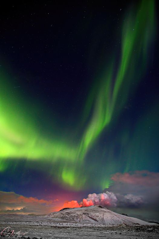
The most impressive action at Reykjanes continues to be at night. That isn’t because of a werewolf nature, but it is because the camera can see the lava much better at night. If you have the chance to (safely) watch lava field, go at dusk. Last night was quite spectacular with a strong double fountain and lava covering the entire flow field. Daytime lava is just as active, but in the light it all looks dark.
Visiting tourism has been on-and-off. The area is at times open, at other times evacuated and closed. It is hard though to keep the watchers away. After all, this is the spectacle of a lifetime, coming after a year of lockdown! There is now a designated access path and a parking area. But SO2 emissions are bothersome. Close to the lava the pollution levels are three times the legal maximum. For those who go, it would be useful to stay upwind and if there is little wind, keep some altitude.

Nighttime lavavision
The eruption has formed four cones on the ridge and two more on the hill on the right. The outer cones went extinct fairly early on. Of the three cones on the ridge, the middle one also stopped, presumably because a big neighbour stole its magma and buried it in its spatter. The second cone from the left has become much more active and is currently building up quite nicely. It is a bit lower on the ridge and gravity favours it. That may suggest that the pressure that feeds the eruption may have declined a bit from its peak, so that the difference in height now matters more. The top cone has also grown further. Since the major collapse of the side, lava has been gushing out on the right and front and no longer on the back. At the moment it seems that the right side has a hole through which the lava emerges. The cone remains very unstable and could easily collapse again. The lesser cone next to it seems to have suffered its own collapse and lava is gushing out on the left. But it is growing rapidly and may even overtake big brother.

Yesterday

Today: the Misty Mountain
As of yesterday, the lava was reported to cover 0.2 km2. It is expanding only slowly, as it is up against the sides of the valley. The total volume was 2 million m3 and the flow rate around 5 m3/s. That gives an average thickness of the lava of 10 meters. Each individual flow is probably around 1 meter in thickness. Close to the cone the lava field has a maximum thickness of 20 meters. If there really is someone buried here, the person got their money’s worth.
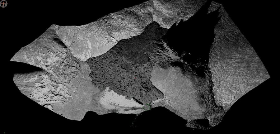
Terrestrial laser scanning of the lava flow field, on Saturday 5pm. It has expanded considerably since. The area behind the cones was invisible to the laser. The shadow instead shows a nice profile of the eruption ridge. Source: Andri Gunnarsson
An impressive video of the lava flow is https://www.ruv.is/frett/2021/03/24/hraunpollar-fljotir-ad-myndast-i-geldingadolum
Note how the lava surface here is a very thin veneer and constantly overturns, with the new surface turning grey fast and pretending to be a lot more solid than it is.
There has been a lot of discussion on how this eruption will develop. How long will it last? Initially, we expected a brief eruption, followed perhaps by another break-out elsewhere along the dike. Instead, it now seems that the eruption is rather stable. The eruption rate has decreased by at most a factor of 2-3, if at all. That has led to suggestions that this will be very long lasting or even very long lasting (years). In the latter case, it might even lead to a proper shield, with a volume of 1 km3 or more. (At the current rate that would take 5 years.) That hasn’t happened here since the early holocene. But these suggestions should be taken with considerable caution. The eruption is only 5 days old. It is very hard to judge the future at such an early phase. Also, few eruptions last more than a few months.
A very exciting finding is that the magma is reported to be ‘primitive’, i.e. from the mantle, not the crust, from a depth of 15 km or more. It is low on TiO2, and this is a sign of a mantle origin. It is unusual for Reykjanes. The new lava is more primitive than lava known from the previous Reykjanes fires, now a millennium ago. Krisuvik (just next door) has in the past erupted fairly similar lava, but Svartsengi on the other side seems to produce much less primitive lavas.
But although primitive (amazing how geologists are allowed to use words that archeologists cannot), the magma did not come directly from the mantle. The crystals in the lavas show that it spend some time at much lower depth, 2-5 km below the surface. That is, it collected in the dike. But the dike itself obtained its magma from the mantle, and not from any intermediate magma chamber in the crust. The lava that currently erupts is fed from the dike.

Reykjanes below the surface. Numbers at the lower right are melt percentages
We can understand what happened by looking below the surface. Reykjanes consists of several layers, as indicated in the sketch. The upper crust is some 5-7 km thick, and it consists of volcanic material. The uppermost regions are fairly low density, while the density increases going down. This is partly because of compression by the weight above, and partly because of a large number of old dikes 4-6 km below the surface.
Below the upper crust is the lower crust, forming a more traditional basement rock. This extends to some 15-20 km depth where the moho is. Below this lies the mantle. The mantle below Iceland is not entirely pristine: it contains subducted oceanic plate material as well.
The mantle is where the melt occurs. Models suggest that the melt begins at a depth of 100 km where the melt fraction is a few per cent, and increases going up, reaching 50 per cent at the top of the mantle. Here is where the melt collects. To get eruptions, somehow the magma has to make its way to the upper crust. the magma percolates up through the lower crust. The lower crust is quite ductile especially along the ridge axis, but it is still a slow process. You might expect the magma to collect in magma chambers where the rock density goes down, at the lower crust/upper curst transition. But that does not seem to happen much in the peninsula. There is no evidence for significant magma chambers in the crust. Instead there may be many smaller melt pockets, which on the right trigger form a dike. This is a bit speculative.
The current dike formed during a phase of significant earthquakes, including an M5.7. A question is whether the earthquakes caused the dike or the other way around. The second seems more likely: the accumulation of magma in the upper crust (i.e. the dike) triggered the Reykjanes fault.
And so, somehow, the dike formed: 10 km long, 5 km high but only a meter wide. Many of the earthquakes were caused by the magma in the dike forcing its way through the reluctant crust. Finally, the top of the dike found a weakness, and managed to split the crust to the surface. It was probably aided in this by a bit of rifting from the earthquakes which had reduced the stress in the rock. The magma is being pushed out by the pressure from the rock on the dike. Imagine trying to hold back a 5 km tall wall of rock, pushing in on both sides: that is the kind of pressure that the magma is under.
What happens next depends on whether or not the dike is still getting new magma from the mantle below. If it isn’t, the dike is now losing magma and it will slowly close: that will eventually end the eruption. The dike would be emptied in no more than 100 days. (This ignores the fact it is also losing heat to the surrounding rock and will partly solidify within weeks.) If it is continuously being fed from below, then we may have a stable situation which can allow the eruption to continue. Future INSAR measurements may show whether the dike is deflating or not. We will just have to wait and see.
So after waiting for 6 years, we are back at watching and waiting. But the watching is mesmerising.
Albert


All this zooming and out with panicking is very distracting from my work… I was almost late submitting my daily report because I kept getting distracted
It’s something they have set up to run automatically.
Automatic webcam movements
No doubt most people have seen the pictures from the webcam on Fagradalsfjall, which shows directly from the eruption in Geldingadalur. These are the pictures that can be found here at the top of this newscast.
There has been a lot of request that we narrow the camera’s field of view around the craters themselves and others want to see the lava field. RÚV has tried to meet these wishes by changing its field of view regularly, without diminishing the documentary value of this recording for geoscientists who intend to use the images for research. And then there are the civil defense and the nature watch, which wants to see conditions on the ground in a live stream.
An automatic camera entry has now been set to meet all of these considerations. The camera moves regularly and shows the craters, the lava field and then the whole area.
Yep I noticed that when I got a chance to check RÚV’s feed… I even made a comment about it below, tough i got distracted by work and missed some of the errors in the translation
Why limit yourself yourself to one camera? Get another and then set one to wide view and the other to cone view. Then consider adding some others around the perimeter, so the backside of the cones can be viewed!
Not complaining, happy to have the the one, but moar is moar better!
https://www.nature.com/articles/s41467-021-21866-1 “Extrusion of subducted crust explains the emplacement of far-travelled ophiolites”.
25/03 10:30
Nýr pistill Veðurstofu um gosið
I won’t copy the whole thing, as it is quite long, but they are saying that there is a direct conduit frmo the mantle to Geldingadalir and that activity is gradually increasing if anything, particularly at night. There is also a chart outlining this, from the FAF instruments.
https://www.ruv.is/frett/2021/03/18/helstu-tidindi-annar-minni-giganna-saekir-i-sig-vedrid
From RUV news feed on 25/03 at 8:21
The lesser vent may have been growing a bit too fast. It is slowly flaking away on the inside.
fast long-range lava flow on the left. perhaps indicates that the big cone now flows into the smaller one?
Maybe, maybe not. I think we’re not quite there yet. From a physics standpoint I have observed it a bit. What i do see is an inward flaking to the left on the lesser vent, which also happens to be the outlet. This may indicate a stronger flow, but I do not physically see it. The fountain also seems to favor spattering towards the left, but it is hard to tell for sure, since a part of the fountaining is obstructed by sight. This may indicate a flow fom the upper cone.
The upper cone-rim has also flaked away on the back-left side, which may indicate a declining support due to more lava on that side. Then again I think it is more likely it’s due to ‘combined heatworks’ of both vents and/or a bit of dumb luck. It’s own outflow may have declined a bit, but it may also be forming a roof. It’s hard to tell.
I’m just a long-time lurker, and I think you’re better at educated guesses ;). What do you see?
Woop, it may just have happened
I doubt it. Its most likely also being fed by the middle vent.
Nice 3D-model of the cone and the closest area surrounding it. Pan, zoom, rotate and get up close and personal with the cone.
https://skfb.ly/6ZT7z
3D model of the cones. It’s probably from a couple of days ago though.
https://sketchfab.com/3d-models/eldgos-i-geldingadal-7bcb3d856e1947a4a78c1810f559b3ea?utm_medium=embed&utm_campaign=share-popup&utm_content=7bcb3d856e1947a4a78c1810f559b3ea
Is the volcano activity influenced by the moon and sun in the way water is affected with ebb and flood? Since at night activtiy seems to be higher than during the day?
There’s a paper here analyzing Holohraun. They found a quite strong influence of tidal forces.
https://www.sciencedirect.com/science/article/pii/S0012821X20300881
Another influential consideration often neglected, for example:

The subject of solar-geo electro-magnetic effects is often considered taboo!
Brain stretching is such an awful exercise it seems to some ?
Unfortunately los draigs refused the link, so I will reiterate:

Trusting that clears the filters !
Btw… There are some who perceive that we live in a mundane atomic structured “reality”…? Our senses condition our perception.
A whole spectrum of other energies await discovery once we have the means to perceive.
This is getting tedious…
(
Trusting that clears the filters !)
Remove the parentheses.
Admin: copied the image so it can be linked. The link above is not directly to the jpg but to a wrapper. WordPress does not allow that.
This paper can be ignored. All their ‘periodicities’ are aliases of the 180-day eruption window. For instance, their 25.6 day period is exactly 1.7th of the 180 days. As they themselves point out, the tidal force is a factor of 100,000 too small to affect the magma.
Not really. It just appears so due to the different lighting at night.
The effects of the tides wont be noticeable by the naked eye.
Actually, although there is the night effect and illusion, there are graphs showing that this eruption activity has been stronger around midnight.
See the RUV newspage at 10.30 this morning.
https://www.ruv.is/frett/2021/03/18/helstu-tidindi-annar-minni-giganna-saekir-i-sig-vedrid
earthquaking on the peninsula also shows greater activity at night over the past three nights.
The latest timelapse. From 1840 untill 0912 next morning. At night i doubled the speed, otherwise 1 second – 1 minute. I did remove bad frames or people in view of the camera.
https://youtu.be/N4MVQsrfTWU
Part of the back wall of the main cone collapsed at 15:01:30.
Also part of the shorter cone collapsed just before at 14:58
This youtube feed has both webcams in one view
https://youtu.be/q3EFNrDhkCk
More of the actual images, and less Iceland flag please!
That would require stretching the video frames or cropping them.
Thursday
25.03.2021 17:59:43 64.496 -17.690 2.6 km 3.0 99.0 5.8 km E of Hamarinn
RUV has compiled the eruption from the day they set up over Geldingardal to today in one minute long clip
https://www.ruv.is/frett/2021/03/25/eldgosid-a-einni-minutu
THE ultimate FUN FILM! Thanks!
RUV News Feed at 13:51
Is there any longer term prognosis yet? What if the eruption keeps going on at this rate for two months … or two years?
Giggle translate. Also the image shows the location of the RÚV cam
“How long can the eruption last? A direct connection now appears to have formed from magma at the top of the mantle to the surface in Geldingadalur. First and foremost, it is the amount of magma at the top of the mantle that determines how much material reaches the surface. It is now about 6 days since the eruption began. Here is a picture that shows the possible spread of the lava 17 days after the eruption began, if the lava flow remains similar to recently. Based on this model, the lava field will reach out the valley on day 12, which is on Wednesday …”
Excellent graphic. I wonder, if the cone(s) were to collapse on the east side, redirecting the flow, whether the lava would breach the next valley earlier than projected?
touristic volcano at its best. The most popular walk path in Iceland now. Despite day time and weather.
https://twitter.com/A_Menshenin/status/1375161868755537922?s=20
New camera angeling/zooming-period from timestamp 19.04.00 – 19.07.10. Enjoy!
Now blowing an absolute hoolie, and it is strong enough to be effecting the trajectory of even some of the mid sized bombs if you watch the zoomed view!
That surprises me, i know that due to the effervescing gas, lava can be relatively low density compared to solid rock, but those bombs must weigh a good number of kilos.
Well… There is that famous case of a lava bomb taking a shepherd’s head clean off… So hasn’t enough to accomplish that
Some activity elsewhere in Iceland. A series of shallow quakes east of Hamarinn in Vatnajökull. Looks interesting. Somewhat outside the usual pattern! Worth to keep an eye on.
The intensity of the volcanic eruption has increased
https://www.mbl.is/frettir/innlent/2021/03/25/styrkur_eldgossins_hefur_aukist/
I am assuming that giggle is to blame, but… “The intensity of the eruption in Geldingadalur has increased steadily in recent days” is followed up by, “The magma flow is estimated at 5 to 6 cubic meters per second and the flow is thought to have changed little since the eruption began.”
You are correct in noting this.
The gap between main vent and “The side Hole” has been breached. New rivulets of lava flowing fast..
In 3d
https://sketchfab.com/models/7bcb3d856e1947a4a78c1810f559b3ea/embed?autostart=1
Kek!
it already looks so different. The baby cone has grown!
Albert,
watching these vents bubbling continuously for many days in their elevated ponds. Is there a conceptual different from lava lake? Or can I imagine these vents as very small lava lakes?
If so – what would need to happen to make it a lava lake?
The term lava lake is used for various types of volcanic phenomena, including rootless lakes that are fed from a vent located away from the edge, or those that represent the top of volcanic conduits. The classic lava lake, for example the one at Erta Ale, is one that forms the top of a very wide conduit and is in a continuous state of convection, lava rises up quietly in some parts and sinks down at places where spattering happens. The ponds of Fagradallsfjall are instead at the top of very narrow conduit, with the width of a dike, it does not have convection up and down the conduit, lava only rises and ponds around the bubbling fountain, then spills over the sides and through tubes. It is not the same as the classic lava lake, but might still be called as such.
Right. So it needs to last longer and be wide enough for convection. I wonder how wide the lake needs to be for convection to happen.
Is it just me or does it look like the cookie monster right now?
Some spectacular foundering in this vid! https://www.ruv.is/frett/2021/03/24/lava-puddles-quick-to-form
The floor is lava!
That’s a rifting fissure eruption alright.
Grímsvötn might want to join in on the action. Small swarm with one M2.0 at Grímsvötn and one M2.4 and one M3.0 at the Loki ridge.
Good we need more focus on action. (wishful thinking)
Iceland is not usually predictable.
As long as Orrablefirejolkal(!) does not get involved we will be fine and in for two or three eruptions at once if we are at all lucky.
If “O” gets involved then run, to EU or US, LOL’s.
Probably be over by Christmas!
New tremors in La Soufriere, St. Vincent. Moving up the risk
https://pbs.twimg.com/media/ExR-1muW8AAT3ma?format=jpg&name=large
This and Taal have been on my radar. Not to mention Pacaya which has been doing some spectacular stuff. The Central American Etna but not quite there yet.
Also new video of the dome. No longer looking like a pudding. Growing in all the area, filling the crater.
https://twitter.com/uwiseismic/status/1375265546934095873?s=20
Taal still restless
https://www.phivolcs.dost.gov.ph/index.php/volcano-hazard/volcano-bulletin2/taal-volcano/11551-taal-volcano-bulletin-26-march-2021-08-00-a-m
Looks like there is a small swarm around Lambafell/Eldborgir. Belongs to Brennisteinsfjallasystem.
“The lava field formed during an eruption in the year 1000, when Icelanders were debating the christening of the nation at national parliament Alþingi at Þingvellir. The story goes that when the eruption started, believers in the old gods claimed that was a token of the wrath of the gods, to which chieftain Snorri Goði is said to have responded “So what were the gods angry about when the lava flowed that we are now standing on?”
Refers to Kristnitökuhraun, the name of that lavafield.
Probably wont be much, Brennisteinsfjoll will probably wake up in exactly the same way as Krysuvik has just done, with a powerful tectonic quake and major earthquake swarm, followed by magma. It is somewhat primed to go now that the tension has been released next to it, but earthquakes are unpredictable so when this will happen is an unknown. I guess some time in the next 1-200 years.
“…what were the gods angry about …”
Can’t fault that logic.
No sign of it calming down. It always looks like its ramping up at night and the last couple nights I would say it was but tonight seems the same. Our twin cones are almost the same now.
My guess is they will merge into one. Then who knows. My gut says (cuz I have nothing else) this will go on for a long time. After 6 months or so will this get boring?
I don’t Think so!!!
Kilauea has gotten boring again now, that is the nature of shield eruptions that last for a long time unfortunately. Most of the time these eruptions are only recognised far in hindsight, Pu’u O’o was the biggest eruption by volume in the last 230 years but it was almost never a big eruption and no one ever paid any attention to it unless it flowed towards inhabited areas or a new lava flow with hig heffusion rate appeared, which were invariably brief.
The massive shields at Trolladyngja and Theistareykjarbunga would have been erupting like this possibly for centuries on end, the just as voluminous Observatory shield complex at Kilauea we know was erupting for nearly 500 years and actively growing for at least 150. But if you looked at any of them erupting it would be a small lava lake and maybe some tiny pahoehoe flows scattered, no massive lava rivers.
Woud be great If the current eruption became a Theistareykjarbunga, because thats lava acessible for 100 s of years in slow Puu Oo like manners. But indeed much less lava at once than we see now. Theistareykjarbunga as chad says was a very slow eruption. In Reykjanes souch eruption woud bury te Sourthen Penninsula and form very nice ocean entries lasting decades .. 100 s of years. But Reykjanes lacks the magma supply for giant monogenetic lava shields.
And no – one knows How the startup of a Theistareykjarbunga looks like
Shields in Hawaii begin with lava flood eruptions, though they are episodic. I would guess a shield in Iceland would be much the same but because known examples lasted so long they bury the initial a’a stage. I think there is a possibility of this happening now at Fagradalsfjall if rifting continues and opens up a lot more space for decompression melting, forcing all of that through a small hole is going to turn this little vent into a geyser from hell 🙂
Eruptions on the Reykjanes peninsula are usually described as fissures but a closer look shows most of the larger flows are fed by single vents along said fissure, with high fountaining and cone formation, very similar to Krafla in 1984, which began as a fissure but was mostly erupted by a single vent.
As a side note I have doubts the really huge lava shields are actually monogenetic, Skjaldbreidur probably is but Trolladyngja is right at the hotspot and surrounded by younger fissures that could just as easily have originated here as from Bardarbunga. At least one of these is historical, the Fjallsendarhraun eruption in 1362, which was like Holuhraun but twice the volume so maybe lasted over a year which is quite impressive for being a fast eruption 🙂 and I suspect many of the fissures south of Trolladyngja are also unobserved historical fissures, they look extremely young in a lot of cases.
For guaranteed lava too you want your shield to be far from the coast, one only has too look at Pu’u O’o again to see how many situations there was of lava flowing directly into the ocean with no visible lava. I remember watching the 61g flow and there was a point where there was no surface lava at all for months, the only lava visible was where it was cascading out of the sea cliff at the end of the tube. If lava flows to the ocean from Chadyngja 🙂 it will probably focus to that point and form a tube all the same and there wont be much lava at all on the surface until the tube breaks or another flow forms.
I am torn between wanting to see this thing open the floodgates of hell or last for a decade so I can possibly see it one day… 🙂
Yes I remember. The flow started quite like this with cones spitting lava but much larger. Then it went underground and lave tubes transported the lava down rift. Not long before the Puna eruption there was still lava coming from it 35 years later. This eruption does not have the magma supply that Kilauea does so no chance it would last 35 years in my opinion. But a few years.. maybe.
I posted earlier about other rumblings going on that need to be watched but I guess the gargoyles in the dungeon swallowed it up. They would be Taal, La Soufriere and Pacaya that has been trying to be the Central American Etna at times with some pretty good video coverage. 2021 is looking up for us volcanoholics!
The vents are really fountaining hard now, particularly the right-hand one. I think there’s been a further jump in the eruption’s vigor. At this rate Geldingadalir has days of life left to it; by week’s end it won’t be a dalir at all anymore. They’ll have to rename it Geldingabunga. 🙂
Lots of wind blowing things to the right. Might be making it look bigger. Iceland is a VERY windy place considering its location. Many big Atlantic storms (and they get big!) seem to head that way. Not to mention the extratropical storms that come that way during the South Atlantic Hurricane season. Flying sheep is the result!!
Still a tiny opening between the two flows, can’t be long now though

Thanks for posting the screenshot so I didn’t have to try! Icelandic kipuka ahoy.
A decent sized crack is developing in the rhs crater’s inner edge. If that goes, there will be a nice lava surge.
The lava flow continues to narrow the kipuka neck.
Close-up panning at 7.55am.
are we now seeing a lava channel forming at Geldingadalur?
Comment count increased from 206 to 211 but I can only find two new comments, the two directly above this one. I checked page 1 as well, looking for comments dated the 26th after 07:15. Nothing. Where are the other three new comments?
If comments end up in the ‘for approval’ queue, they can be added to previous pages when approved
Looks like the kipuka is formed. There’s a good-looking flow headed southwest.
I’m seeing a tide mark developing alongbtge southern side of tge channel moving through the middle of screen. The lava level is dropping, which tells me it is eroding down to a new base level. The lava may overflow to the south if this continues for any length of time.
I had to look it up:
Kīpuka
A kīpuka is an area of land surrounded by one or more younger lava flows. A kīpuka forms when lava flows on either side of a hill, ridge, or older lava dome as it moves downslope or spreads from its source. Older and more weathered than their surroundings, kīpukas often appear to be like islands within a sea of lava flows.
Nope, not yet. Check the webcam from mbl.is which is from the other side and you will find that the two flows have not connected yet.
Sigh. I really must curb my enthusiasm and check all sources!
The pond has drain ed quite significantly and left a good-sized bench.
Do you have the link for this please Tomas? I can’t find it whenI google ‘mbl.is webcam’.
You can find it here:
https://www.mbl.is/frettir/innlent/2021/03/25/beint_eldgosid_i_fagradalsfjalli/
Direct link to fullscreen player:
https://k100streymi.mbl.is/p2p/mbllive?v=1
I often have to try several times before it starts.
Thank you so much!
do you have a link to this live cam?
Is there an Icelandic term for a kipuka?
I don’t think so. But I’ll defer to the locals.
There might be, I don’t remember one of the top of my head but we’ve got so many semi-obscure nature words that just “click” once you hear them…
It might be something as simple as “hrauneyja”
Since yesterday there were 39 earthquakes a little west of Þrengsli (SE of Reykjavik). They are all at about 5-6 km depth. I’m wondering what this is all about.
Crust responding to the stress? There has been some uplift near there. The time to start worrying is if the eq count is in the hundreds or thousands; or, if the earthquake swarm extends significantly NE from Keilir or Krysuvik.
That hump in front of the cones really grew over night, at this rate by tomorrow morning it might be the same height as the big cone. Wonder what will happen then.
Offtopic: every time i refresh the page or after x amount of time the site automatically logs me off. Does this happen to everyone?
I cannot like posts, as it asks for my wordpress password every time I try and says it’s not correct (despite me being logged in with the exact same password!)
Same here.
More people have that issue that they are constantly kicked out after commenting or refreshing the page. We are investigating what causes this weird behaviour, and we keep digging…
It is a known but obscure problem that our it people are trying to figure out. The site is run (and paid) by volunteers!
I’m glad to not be ejected after each post!
I, for one, am very grateful for all you volunteers and dragons. Is there any way to help the upkeep?
We are always interested in guest posts. They can cover a wide range of topics.
Pingback: Pacaya volcano, Fuego, Klyuchevskoy, Popocatépetl, Merapi,… / VolcanoDiscovery – Whiz
The lava is erupting at 1190 C now
Making it the hottest eruption ever seen in Iceland on modern cameras .. Lavas this hot rarely erupts on land .. mostly limited to fast spreading ocean ridges in pacific
There are people doing something (testing?) right in the steaming area on the left hand side of the lava flow, where there was what we thought a possible eruptive rift a few days ago.
Probably just sight seeing, perhaps drawn to the steam emission in that area?
I assume that steam is a result of water flow onto the lava field, which would be logical if the gully is from water erosion. There have been a few other semi permeant spots of steam emission at the edge on the right hand side of camera, probably for the same reason. It would be great however if we could have some close up shots of that gully, just to confirm one way or another if the fissure extended that far.
I’m more concerned about the people on the right hand side of the live cam, surely that’s down wind and a rather bad place to be unless they have protective equipment?
Hope the person on the right of the RUV image knows what they are doing. The site is closed to visitors due to gas emissions and expected bad weather.
Have they measured the temperature by stickning probes in the lava? or just by remote? Lava cools quickly on the surface when exposed to air .. so you never gets correct readings by surface temperature
Small lava tube windows or penetrate probe into live lava flow ..is the only way to get correct lava flow temperature
They say 1190 C and thats really hot
I assume it would be from thermal imaging of the fountains and lava pool in the cones?
Lava pools always have Some kind of crust on .. even If that crust is hot and plastic and glowing .. perhaps its the spattering bursts they measured 1190 C
Nice stream of ruv.is cam with live seismic and weather data inside the pic. It’s pretty cold in Vogar -6.3 °C?
I prefer OBS studio for live streaming, but my PC is still confiscated by the local police and with the Sony Vaio (2×2.1 GHz Intel Centrino / 4 GB RAM) from my wife, it’s on the edge to still be able to stream with a good flow…
https://youtu.be/T_9z9-ndZnA
With this low air temperature, the steady snowing and the snow-covered landscape in the background, would we agree that the lava field surroundings, the brownish snow free areas, are getting warm because the heat from the lava is slowly transferred to this areas? How deep? How hot? What’s about ground beneath the fresh lava?
Or is the snow just sublimated into and/or reacting with the dry volcanic gases/steams/smokes?
Any eyewitness reports or even better measurements known?
Close up sequence starts @ 13:23 @ https://www.ruv.is/frett/2021/03/20/beint-vefstreymi-fra-eldstodvunum
Wow! just getting my first view this morning. Things sure look different. The ridge that people were standing on a couple of days ago is now covered in lava. and the twin cones are now almost if not merged. It also looks like the lava flow has gone around the backside and is heading down the valley.
There was a lava spurt from the main cone just after 13:45 and lava flooded in various directions over the growing slope. 6 minutes later a bit of the top of the cone collapsed. It will regrow quickly enough.