One from the archives (from 2013, with small additions). Karen Z on Snowdonia
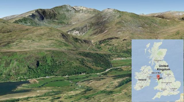
View of Mount Snowdon using Googleearth by Karenz
The British Isles have an extreme diversity of geology. Travel 20 miles from just about anywhere, and you’ll find a region with a very different history. Almost every geological division of time left a mark somewhere here. I live on ice age sediment, thick, back-breaking yellow clay to be specific. But 10 miles from here are remnants of ancient coral reefs. The oldest rocks are well over 2 billion years. There is desert sand, deep ocean sediment, remnants of ancient Himalayas, flood basalts. The ancient tin mines of Cornwall are a geological inheritance. There is an ancient volcano, in the Lake District, a name which draws attention to its tranquility and beauty, rather than its volcanicity. There are reasons for this geological wealth. The British Isles were often on the edges of plates, where the action was. Not always – when you are on the edgeof an ocean, that ocean may one day vanish and you’ll find yourself in the dry centre of a newborn supercontinent. It has happened here. But one day that continent will break again, and often that break will be where the parts last came together. The ocean will return, and the British Isles once more find themselves on the edge. The isles are most at home when the ocean is close.
Snowdon is the highest mountain in Wales and an extinct volcano. The summit is easily accessible on foot, by train or you can practice your mountaineering skills there – as apparently did Sir Edmund Hillary to train for the ascent of Mt Everest. I walked it; mountaineering is not one of my skills.
Snowdon is well worth a visit as it is in a national nature reserve for rare flora and fauna.
Wales has had a marked influence on geology. Early geologists defined periods based on the names of Welsh villages. “Ordovician” is named after a Celtic tribe, the Ordovices.
Snowdon formed during the Ordovician period. It is comprised of tuff with sedimentary rocks and igneous intrusions, folded into a syncline. Around 450 million years ago, a caldera formed, producing ash flows of rhyolitic tuff deposits up to 500 metres (1,600 ft) thick. The current summit at 1,085 metres (3,560 ft) is near the northern edge of the caldera.
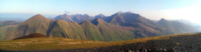
Fig 1: The Snowdon Massif (Wiki Commons)
Much of Wales was under water in the Ordivician period. Wales was in a back arc basin between a subduction zone and in front of the Midland Platform. The basin had both submarine and sub aerial volcanoes. While I have focussed on the volcanic activity, there was a lot of sedimentary activity occurring as well so igneous and sedimentary rocks often form consecutive layers.
Tectonic Setting
England and Wales were part of the Avalonia micro plate; Scotland was then sited on the Laurentia plate and did not join England and Wales until much later during the Caledonian Orogeny. In the early Ordovician period, Avalonia was a volcanic arc on the northern edge of Gondwana where the Iapetus ocean crust subducted under the Gondwana plate. As the Iapetus Ocean closed, Avalonia broke off from Gondwana and moved northward to eventually meet the Laurentia and Baltica plates.
The collision of the plates resulted in the Caledonian Orogeny around 490 ma to 390 ma, the building of a chain of mountains which stretched from the Appalachians, through Snowdonia and the Lake District to Norway.

Fig 2: Caledonian/Acadian Mountain Chains (Woudloper, Wiki Commons)
Volcanic Activity
For Avalonia, volcanism of the Tremadoc era, c. 510 ma, was island arc, whereas the subsequent volcanism of the Llanvirn and Caradoc eras was characteristic of a back arc environment. Wales, itself, was the site of a back arc basin with voluminous calc-alkaline basaltic and rhyolitic volcanic activity which ended with the meeting of the three terranes in the late Ordovician. Acidic lavas were produced by subduction and basaltic lavas were produced by thinning of the crust of the back arc basin.

Fig 3: Profile of a Back Arc Basin and Subduction Zone (zyzzy2, Wiki Commons)
Early volcanic activity in the Tremadoc was subaerial, followed by a period of submarine activity in the Caradoc and subaerial again in the Ashgill.
The Snowdon Volcanic Corridor
The Snowdon volcanic corridor was built in two phases: the Llewelyn volcanic group and the Snowdon volcanic group. These are separated by sedimentary rocks.

Fig 4: Snowdon Volcanic Corridor (based on a map by Nilfanion, Wiki Commons)
The Llewelyn group had five main formations: Conway – rhyolite and ash flow lavas; Foel Fras – andesitic lava and tuffs; Foel Grach – basaltic – andesitic lava; Braich Tu Du – acidic ash flow and rhyolitic tuff; and, the Capel Curig – formation of both subaerial and submarine acidic ash flow and tuffs.
The Snowdon Volcanic Group had three centres: Llwyd Mawr – an emerging volcanic island that produced acid ash flow tuffs that were partially contained in a subsiding caldera; Snowdon, itself; and, Crafnant –deep water acidic submarine tuffs. Snowdon evolved as initial ash flow tuffs from a series of fissures south east of the volcano. The caldera subsided as more ash was erupted. This was followed by pumice and rhyolite. Ash flow tuffs were partially contained by the caldera.
Basaltic rocks also occur alongside acidic: both intrusive and extrusive basalts are found and also hyaloclastites. The sequence is acidic followed by basaltic and then a final rhyolitic phase. It is bimodal: there are basaltic and rhyolitics, but not much in between.
At the end of the Caradoc, most volcanic activity ceased, although there were some minor eruptions later in the region. Successive orogeny episodes led to mineralisation of the faults in the region and further uplift. There are no rocks in the area that are younger than the Triassic period. Any that might have been deposited have since been eroded. Glaciation during the Cenozaic Ice Age and subsequent erosion from wind and rain formed the current landscape, revealing the underlying geology of Snowdonia.
The original caldera was 10 km across. It erupted three main sequences: the lower Lower Rhyolitic Tuff Formation, the Bedded Pyroclastic (basaltic) Formation, and the Upper Rhyolitic Tuff Formation. The basaltic melts came from a compositionally heterogeneous (volcanic arc) mantle which had as much as 60% crystallization during ascent. This fraction of crystallization still leaves SiO2 contents close to that of the primitive magma, so that the magmas remain basalt or basaltic andesite. Snowdon is heterogeneous, showing there were multiple magma chambers where this happened to a different degree. There may have been 500 km3 of magma in the chambers. The basalt erupted in two phases, the second one when the caldera underwent resurgence. The second phase had multiple basaltic flows. There was a third basaltic intrusion but that magma reached the surface only after it had evolved into rhyolite.
The rhyolitic magmas formed by crustal melt merging with one or more of these basaltic chambers, followed by further crystallization. This happened after all three basaltic intrusions. Three main rhyolitic layers formed in the million years after the first basaltic phase. The first one was 2km3, but the second ash layer was much larger and may have exceeded 603. This eruption caused the collapse of the first caldera. The resurgence after the caldera formation gave rise to the Bedded Pyroclastic Formation, comprising basaltic eruptions. This was followed by (and perhaps interspersed with) several rhyolitic eruptive phases, which together ejected 20 km3. The rhyolitic eruptions came from shallow, short-lived magma chambers associated with dome formation. One could envisage a mush left behind underneath the collapse caldera, with a series of smaller chambers within the mush or above it, closer to the surface.

And then it ended. Almost half a billion years later, we can still walk around the remnants of this ancient volcanics.
KarenZ, 26/12/2012.
References:
http://en.wikipedia.org/wiki/Avalonia
http://en.wikipedia.org/wiki/Ordovician
http://en.wikipedia.org/wiki/Snowdonia
“British Regional Geology Wales”, M F Howells, British Geological Survey, 2007
“Geology of Snowdonia”, Matthew Bennett, The Crowood Press, 2007.


Iceland’s ice is in the news. https://www.bbc.co.uk/news/science-environment-55346329
Wauw. That is impressive, and sad at the same time
Melting glaciers in Iceland can enhance volcanism there by decompression melting of the mantle below Iceland when the the burden of ice is removed.
Takes a few centuries to have a big effect though.
Thank you for this re-post.
Snowdon, despite the fact that it is so accessible, and often the summit and all the main paths are crowded when the weather permits, is still I think my favourite mountain to climb. Every one of the main paths seems to offer something…The Pyg Track, with its immediate climb to spectacular views from jagged rocks out over the Irish Sea…The Watkin Path (my favourite) with its twisted oaks and cascading stream, followed by some Tolkienesque “Mordor-a-like” desolation around the ruined mines, and the lung busting and eventually quite exposed final pitch.
I just find it intensely beautiful.
4.1 On the big Island
2021-02-01 19:13:09 4.1 3.9
My guess is that it is an aftershock of the big quake two years ago.
Yes that is most likely the case, apparently all of the southeast flank earthquakes on Mauna Loa are considered aftershocks of the 1868 quake even today, and to an extent the 1975 and 2018 quakes on Kilauea can also be considered aftershocks of this as Kilauea also moved in the 1868 quake.
I do wonder sometimes, in 1868 Kilauea didnt have as much active magma storage as it does today (east rift was not as open) so its collapse in that year was intrusive despite probably being the biggest collapse since 1790 up until 2018, if that were to happen today the results would be I think very different, the caldera will probably have to refill a bit first but that wont take long with the current activity. Mauna Loa obviously had a major eruption in 1868 that probably caused the whole thing. It is also heading towards another major eruption in the future, if in the process it ends up shoving its south flank into Kilauea then things could get very interesting…
The current Kilauea eruption started when the south east flank of Mauna Loa shifted a bit down, back in October. That caused some deflation at Mauna Loa and started the pressure increase at Kilauea. The two volcanoes are independent, but Mauna Loa gives a lot of peer pressure to its little brother. Of course you can never be sure of what caused what, but the change in Mauna Loa was quire notable, and can be traced to earthquakes where the lavas of Kilauea overlay those of Mauna Loa.
Thats not what caused the current eruption, since June there has been overpressure at Kilauea which is actually still being relieved at Pu’u O’o, where it is most obvious in the GPS.
The signal that looked like deflation at Mauna Loa was caused by the source of inflation moving north of the caldera and temporarily causing that reading to show a contraction as the north caldera GPS moved south. HVO just released a video on Mauna Loa with all the INSAR data and GPS directions over the last year and it shows no deflation has occurred in the last year just a change in the location of inflation relative to the instruments. The earthquakes in September were probably caused by Kilauea, the area is not considered specific to either volcano by HVO.
Eruptions have more than one cause. You need a magma supply, you need pressure, you need a weakness. All three together determine when exactly an eruption happens. There was a clear fairly sudden change on Mauna Loa with contraction and deflation, following from those earthquakes. It was fast and afterwards the inflation continued as before. And what you call ‘a change in location of inflation’ is the same as slippage on the south flank of the caldera. I do expect that the change in Mauna Loa affected the pressure regime at Kilauea.
I don’t think there is much evidence for a relation between the swarm near Kilauea and the deformation at Mauna Loa.
The swarm that happened near Kilauea was a Namakanipaio sequence, they are well known and have been recorded many times before, ever since there is seismic monitoring, always at that same location (the Nāmakanipaio Campground). If there were related to Mauna Loa or Kilauea that would be clear by now, but no obvious relationship has been ever observed, they seem to be just tectonic swarms, this time it just coincided with something going on at the volcanoes that was probably unrelated.
There do not appear to be any signs that the flank of Mauna Loa slipped, there is nothing in the GPS like PIIK, ANIP or MLPR that are located between Kilauea and Mauna Loa. There were no unusual earthquakes along the N-S band of earthquakes of the Hilea-Kaoiki Seismic Zones that extends from Pahala to the Northeast Rift Zone of Mauna Loa which would flare up if its flank was to move.
Instead deformation suggests Mokuaweoweo deflated, which is magmatic. The increased inflation of Kilauea was also underway a little earlier that the contraction of Mokuaweoweo Caldera, but I doubt there was any connection between the two events, volcanic stuff happens so frequently at Hawaii that unrelated events are bound to coincide from time to time and there needs to be additional proof.
Earthquakes related to the flank motion of Mauna Loa take place at the Hilea-Kaoiki Seismic Zones, which it’s where the edge of Mauna Loa’s deep rift (the high velocity material area very roughly depicted in the image) pushes against the basal fault of the island that occasionally ruptures in large earthquakes. Expansion of Mauna Loa’s deep rifts is currently much more slower than spreading at Kilauea as clearly visible in the image:
The last significant slip of Mauna Loa’s flank was in 1983:
I think that there is a bit too much emphasis on Mauna Loa being the overall driver of the volcanism of the island. When HVO was founded in 1912 Kilauea was not as active as it is now (summit was very active but no flow within the rift zone) and Mauna Loa had a higher frequency of activity than is typical of the last millennium, so much so that Jagger though it was the younger volcano. The situation now is very different, Kilauea isnt big enough to actually push Mauna Loa but it is likely the dominant player in interactions now, HVO has noted the flank of Mauna Loa sped up after 2018, and both quake rates and deformation negatively correlate with eruptions at Kilauea, almost an exact but mirrored effect of what was observed in the early days of HVO.
Sleeping giants are still giants
Well it wont be able to sleep much longer, its going on 19 years of continuous inflation, 1984 took only 9 years and that was interrupted. 37 years without any eruptions at all is also not crazy but is decidedly longer than normal. I do expect there to be a significant eruption within the 2020s.
The last dike went down the northeast rift so maybe the next eruption will be southwest. A major eruption in Ocean View estates, especially a caldera formation like the early 1700s Hapaimanu eruption, could be a disaster to say the least, like fissure 8 x10 and on a steep slope…
I do wonder if a rupture of the decollement (basal) fault in front of Kilauea can propagate to Mauna Loa’s side of the island too. In 1868 the rupture was triggered by a dyke intrusion in the SWRZ and propagated from the Hilea area to the entire mobile side of the island in a M 7.9 earthquake, as far as Kapoho (and beyond?), the flank subsided a few meters (relaxed). The movement of Mauna Loa’s flank is pointed towards Kilauea’s flank, who instead points away from the island, so maybe a full rupture of the basal fault can only happen when Mauna Loa starts it?
That would mean a full rupture is unlikely to happen until Mauna Loa becomes dominant again with frequent dyke intrusions and deep rift growth.
nice maps from St. Vincent. The dome is not stopping.
https://twitter.com/uwiseismic/status/1357010972809003012?s=20
New post is up! Bravo!
https://www.volcanocafe.org/the-missing-piece-part-2/