Seeing a hill rise up in front of your eyes where there was a lake just weeks before, and seeing it happen close to a major city, that would be something. Perhaps the Neapolitans could have stayed away – after all, the people living close-by were being pummelled with pumice while the new hill grew and they had every reason to be somewhere else. But whilst the locals fled leaving their possessions behind, people from Naples flocked towards the eruption to get a better view. None of them knew about Pompeii – that town had been lost and forgotten about – and neither would they suffer its fate. But this was an experience worthy of Naples. (It was also the only eruption with a Macchiavellian connection, but that is another story.)
Naples is known for Vesuvius, a sleeping giant which shows no indication of re-awakening. Vesuvius is like the other version of Sleeping Beauty, the princess which every prince should be desperate to stay well away from. This princess breaths fire; she is like the nameless dragon which killed and was killed by Beowulf. Tolkien turned it into Smaug, sleeping on the dwarf hoard, with Bard given the role of Beowulf. Its prince needs the guile of the Prince of Machiavelli and let sleeping princess-dragons be. (Remember how Maleficent transformed into a dragon in order to stop the prince waking up the sleeping beauty Aurora? Naples is like that.)
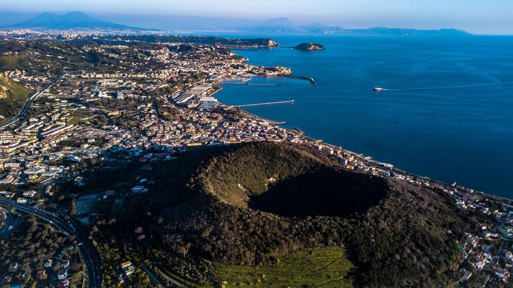
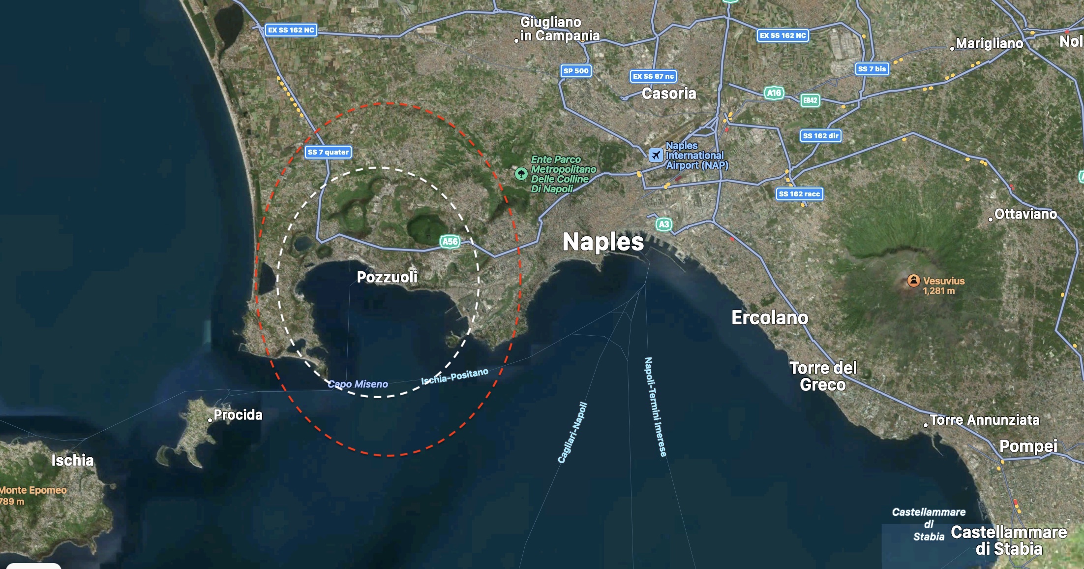
But there is more to Naples than the dragon of Vesuvius that will inevitably one day curtail the encroaching city. To the west lies an older, and larger dragon, the ‘Ancalogon the Black’ of Naples. The town of Pozzuoli lies at her heart. These are the Phlegrean Fields – Campi Flegrei, a region that once burned Europe with her fire. The dragon sleeps – underneath the most densely populated caldera in the world. Over a million people could be affected if any prince dared to wake her.
Prehistory
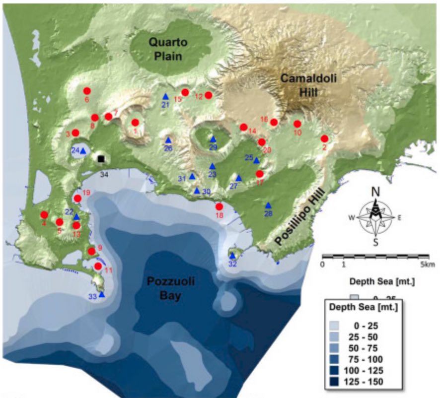
The Phlegrean Fields form a nested caldera, meaning there have been several caldera-forming episodes which created slightly different but overlapping calderas. There were in fact two major eruptions. The older caldera dates from 40,000 years ago and was formed in the Campanian Ignimbrite eruption. It is around 12 by 16 km across, but only parts of the rim survive. The eruption was probably mid-VEI7 but the precise volume is quite uncertain. It may even have been two separate eruptions. The younger caldera is from 15,000 years ago and erupted the Neapolitan Yellow Tuff. It was smaller (low VEI-7) and only partly obliterated the older caldera.
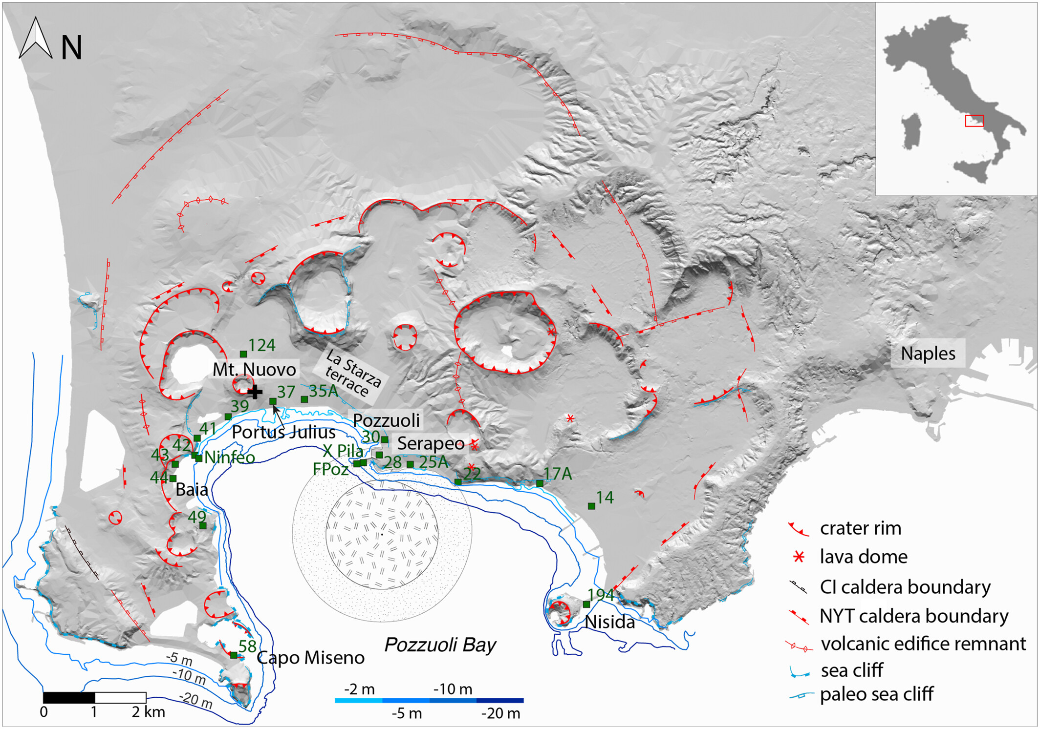
The dashed lines in the map show the approximate locations of the calderas. Red is for the Campanian eruption and white for the Neapolitan eruption.
(This history is not universally accepted. It has also been argued that the Campanian caldera was much smaller and that the current caldera is mostly due to the younger eruption. )
Sometime after the younger eruption, the caldera flooded. The original collapse had left the caldera near sea level. But the eruption happened during a time of rapid sea level rise as the ice age drew to a close, and as it rose the sea transgressed into the caldera. By 6000 years ago sea level had risen by around 100 meters. For much of this time, the caldera was a marine bay, with an estimated depth of 100-150 meters at the centre. But there was also resurgence in the caldera which over time balanced the sea level rise. While this was going on, the region alternated between wet and dry, depending on which rose up faster, the sea or the land.
During this time, the dragon of Campi Flegrei had not fully fallen asleep, or perhaps she had restless dreams. At times, a new eruption or explosion would leave its mark on the caldera. These eruptions were very much smaller than the big ones (most were VEI3 or 4) but they left the caldera pockmarked with cones and craters. There have been some 70 eruptions in the caldera since the Neapolitan collapse. These were monogenetic, meaning each came from a separate magma intrusion in a new location. At first, the eruptions occurred mainly close to the caldera rim. Many of these earlier eruptions happened below sea level. Around 8000 years ago the caldera went quiet. About 6000 years ago eruptions resumed with 20 eruptions over a period of 2500 years. The new eruptions occurred mainly around an uplifted block within the caldera. And 3500 years ago the caldera went quiet again. There is only one eruption known after this: Monte Nuovo.
Eruption sites of the past 12,000 years. The older eruptions are in red and the younger ones (less than 6000 years ago) are in blue. Image from Giuseppi Roloandi et al, 2020, in: Vesuvius, Campi Flegrei, and Campanian Volcanism
The uplifted block is on-land near the coastal town of Pozzuoli. The well known sulphur field, Solfatara, is also associated with this block. Another locus of activity exists off-shore, at the centre of the Bay of Pozzuoli. Both sites, near the city and in the centre of the Bay, show tectonic earthquake activity. It is all in the faults. There is a bit of folding in the region, with one side (the anticline) near Pozzuoli and the other side (the syncline) in the Bay. The uplift has been focussed on the anticline whilst the syncline is a location for magma upwelling.
The larger region in which Campi Flegrei is embedded shows extension, in the form of a 30-km wide graben which runs from northwest to southeast. Over the past 150,000 years, there may have been as much as 750 meters of subsidence within this graben. The volcanic activity is likely related to this extension.
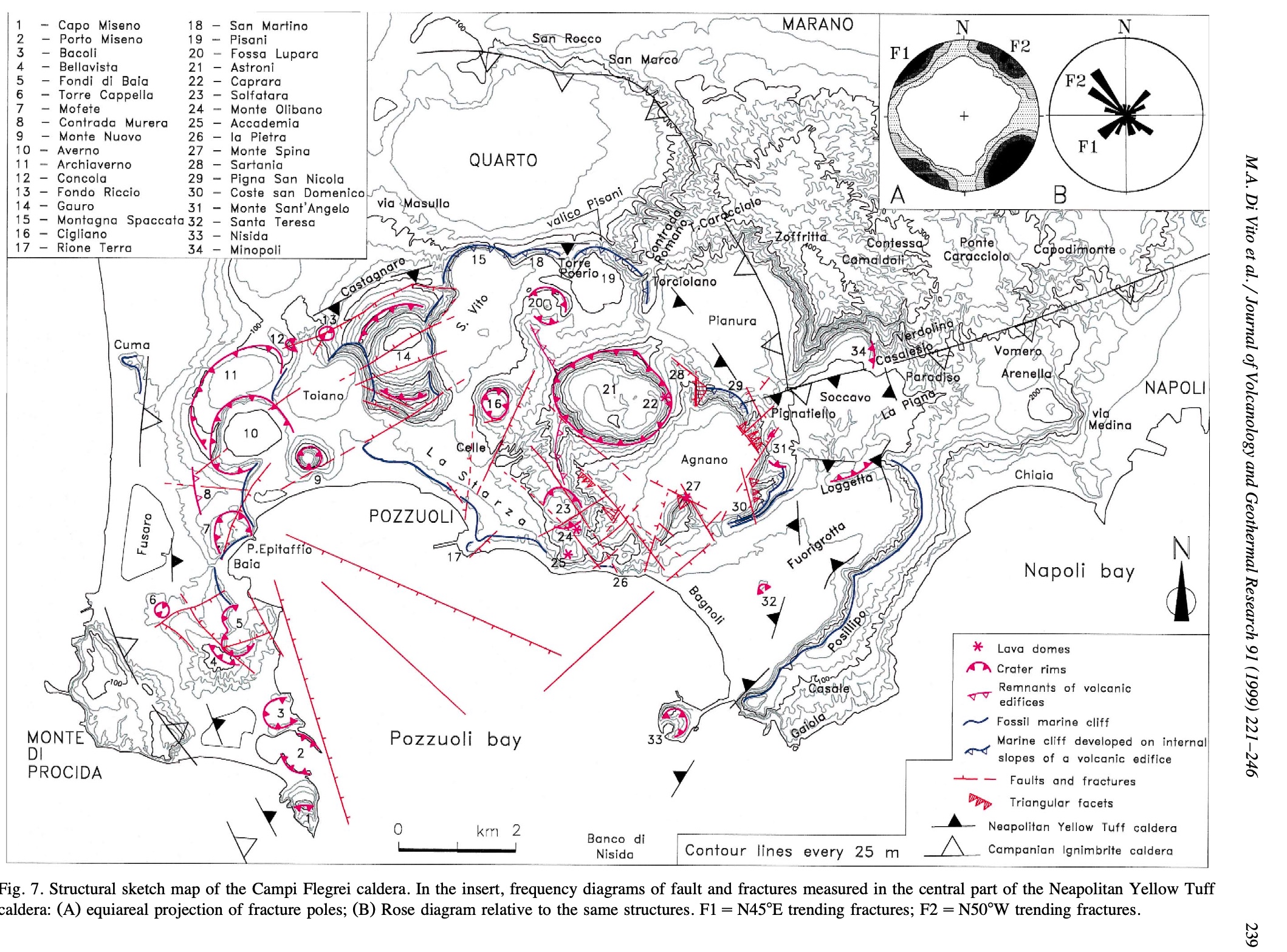
The must-have map of volcanic features of the Phlegrean Fields. Click on image for full resolution
Ups and Downs
The Phlegrean Fields show signs of the sleeping dragon underneath. It belches not fire but steam, in the form of numerous fumaroles (especially in Solfatara, one of the eruption sites of 5000 years ago). It also moves up and down over the years, as if breathing. The ups and downs are called bradyseisms (literally: ‘slow movements’) and they are characteristic of large non-erupting calderas. Although magma may be involved, much of the height changes are caused by underground movement of heated water.
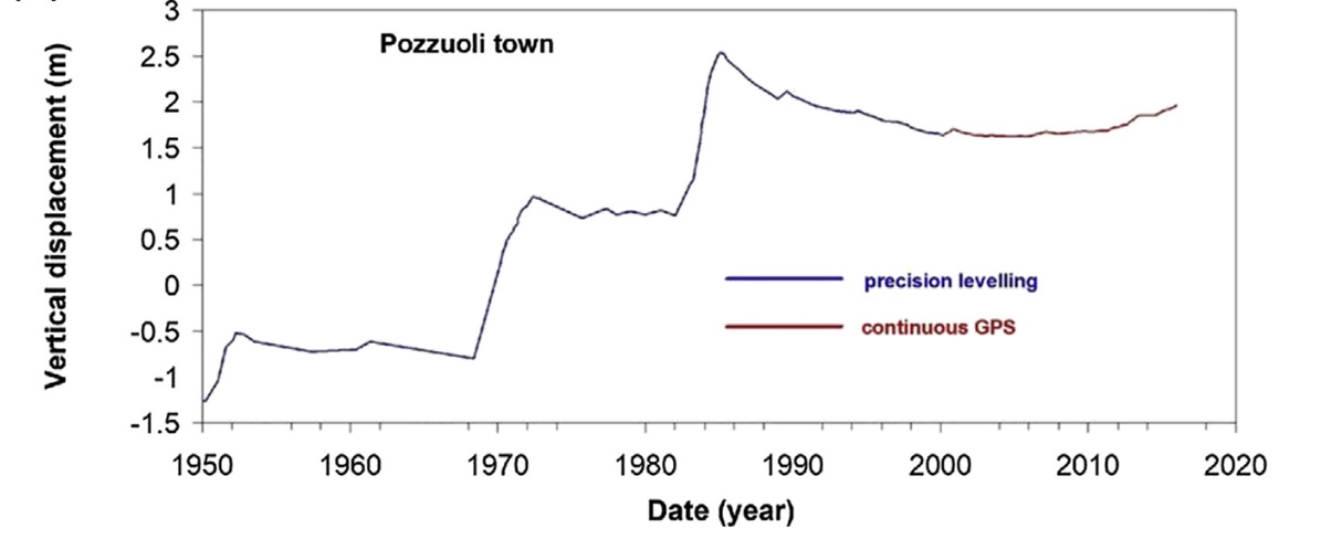
A notable episode of fast changing levels occurred between 1960 and 1990, when the town of Pozzuoli was uplifted by 3 meters. In the Netherlands, such a change (hopefully up rather than down) would have been world news! Since 1990 the town has been slowly going down and more recently up again, but nothing like the exciting days of the 1980’s. The underground water that is causing (some of) this has two origins. There is water present at a depth of 2 km which comes from the Bay of Pozzuoli, while another water reservoir at 8 km depth is much older and is associated with a magma reservoir. The 2-km layer is associated with a cap rock which is poorly permeable, so that water can collect below it. The fast episodes of the 1960’s and 1980’s were related to changes in the shallow reservoir. The slower changes over the past two decades come from the deeper one.
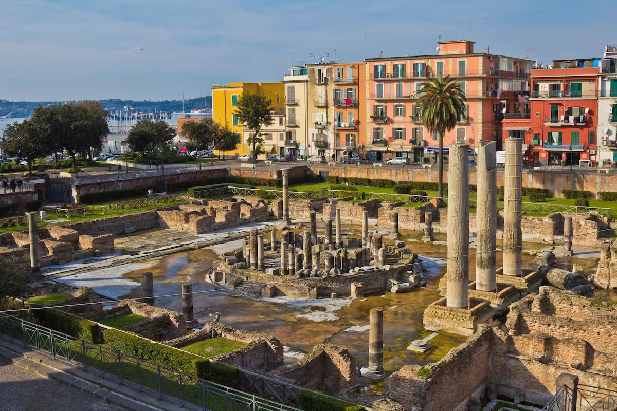
The Roman pillars of the market pace of Pozzuoli
There is nothing unusual about the recent changes. Ground levels here have long been changeable. The Roman pillars at the old market of Pozzuoli show that the village was well above sea level in their days, 2000 years ago. But damage done to the pillars by marine organisms show that at later times they were submerged by more than 7 meters! There is one drawing from the Middle Ages showing the pillars sticking out from the sea, with the market square itself below the water line.
Hot water is of course in demand, and Campi Flegrei has plenty of that. Agnano, a large crater in the Phlegrean Fields, was known for its thermal baths already in Roman times. But this did not last: it became a crater lake in the Middle Ages because of the subsidence. The lake was drained again only in the 19th century.
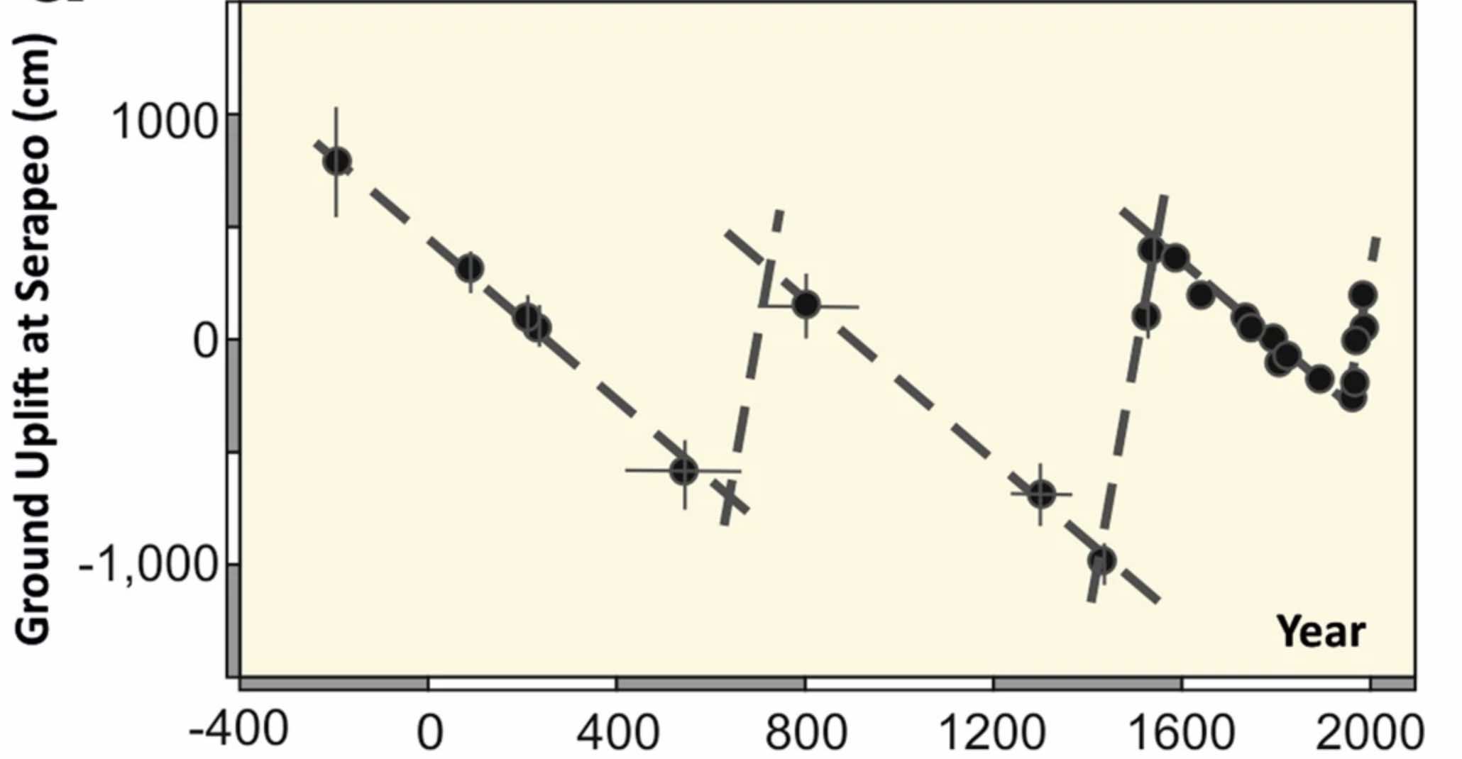
There is other evidence for height changes. Out in the Bay of Pozzuoli are the remains of two Roman roads, now submerged: in Roman times, the coast line was not where it is now. Some, but not all, places recovered from the deep subsidence of the Middle Ages. There is a Roman harbour now 12 meters under water! No – no Dutch person would have build a town here.
After the Roman era, the region subsided at an average rate of 1.7 cm per year. That sounds acceptable, but it amounts to 1.7 meters per century! At times the subsidence went even faster. There were a few reversals, such as in the period 600-700, in a period of perhaps 200 years prior to the Monte Nuova eruption, and in the period since 1950. The town of Pozzuoli ended up being partly submerged midway through the period but close to its old level after the 1538 eruption. But some places along the coast line did not fare as well, as shown by the submerged Roman roads.
Source: Kilburn et al. 2023, Communications Earth & Environment 4, Article number190
More detailed studies have used the Serapeum pillars mentioned above, by carbon dating the marine bore holes. When the market was first built, the floor was 13 meters above sea level. Around 200 AD, a new floor was constructed, raised by 2 meters above the previous one. Was this because of intruding sea water? Another restoration took place in 394, so at that time the market was not yet flooded. By 540 AD (from the carbon dating) the pillars were submerged by 7 meters. This indicates rapid subsidence in the 5th century, by as much as 15 cm per year. Such rapid change can only come from migration of underground water. In fact, during 1986 a similar rate of subsidence was reached in Pozzuoli, and this was attributed to loss of pressure in the water system that feeds the fumaroles of Solfatara.
Those fumaroles of Solfatara have been long known. Strabo (roughly the year zero) wrote “above the city (Pozzuoli) lies the Forum of Hephaestus, a plain shut in all round by exceedingly hot ridges, which in numerous places have fumaroles that are like chimneys and that have a rather noisome smell; and the plain is full of drifted sulphur.” There are even two reports of a volcanic explosion in Solfatara in 1198 . But these reports are from centuries later: no document around the time describing Solfatara mentions an explosion. It has been suggested these reports actually refer to the earthquakes in 1498 (during the run-up to the eruption) and that the date of 1198 is a typographical error. The 1538 eruption of Monte Nuova is therefore considered as the first eruption at Campi Flegrei for 3000 years.
Prelude to the eruption
Often the signs of an impending eruption are recognized very easily – but only in hindsight. Volcanic 20:20 foresight only comes after the fact. So it was here. The old records show indications that something had been brewing but these signs could not have been recognized as such at the time.
Recent studies indicate that slow re-emergence of land lost after the Roman period started after 1250. Around 1300, new buildings (churches, actually) appear at Pozzuoli in a place which previously was submerged. The inflation was probably ‘only’ a few meters. This period may also be when the old market square with the Roman pillars resurfaced. It was the first indication of a change at Campi Flegrei since the deflation had begun a millennium earlier.
The first direct sign of re-activation started in 1470. Between 1470 and 1472 there was an earthquake swarm, strong enough that damage to buildings in Pozzuoli is recorded. More gas was emitted by nearby Solfatara, sufficient to kill trees. After 1472, it appears things quieted down again, although a few earthquakes continued to be strong enough to cause damage.
Around 1500, another slow change was becoming obvious: the land was rising. This was clear because the shoreline was receding. New land became available for people to use. That did not go unnoticed by people in need of new houses because of the damage done to the old ones. A declaration in 1503 was made that the new land belonged to the University of Pozzuoli. Another declaration regarding ownership of new land was issued in 1511, so apparently the sea was still withdrawing further. Between 1250 and 1536, the promontory at Pozzuoli had risen by 14 meters. The coast further west had inflated by 5-8 meters.
Pozzuoli
In between these declarations, there were strong earthquakes in 1505 and 1508, causing significant damage in Pozzuoli. Again, it quieted down apart from a damaging earthquake in 1520.
Crisis
Things suddenly turned for the worse in September 1536 when the earthquakes became much more frequent and more severe. In February 1537, reports state that many houses in Pozzuoli had been damaged, some severely so. People began to leave the town. At the same time Solfatara became smellier.
On April 20, 1538, an earthquake was felt in Naples strong enough to cause fear. Activity continued for the next months, and the earthquakes became progressively stronger and more frequent over the summer. This peaked on September 14, only to restart on September 20. By September 22, people began to sleep outdoors, away from the ruined houses. The shaking continued and became near continuous by September 27. In distant Naples, 5 to 10 events were felt per day. Even for the Neapolitans, this got a bit much.
Run up
On 28 September, people notice a ‘dissection’ of the sea. Just off-shore, a ridge is uplifted to 4.5 meters above sea level. It isolates a bit of water which is covered in dead fish. The remaining locals see an opportunity: the region’s famous entrepreneural spirit regarding ownership was alive already! The fish are quickly collected and taken to Naples to be sold at the market. Perhaps the fish had been killed by sulfur being released into the water. Around this time, wells in Pozzuoli (several kilometers away) begin to fill with water. The land here may have begun to deflate as the activity moves further down the coast.
During the night, the earthquakes continue. Hardly a house is left undamaged and many are close to collapse. People sleep outdoors.
Now something strange happens. In the morning of September 29, along the coast near to where the ridge had formed, over a period of a few hours, a region around 200 meters across deflates by some 4 meters. The hole begins to fill with water. Around noon the deflation reverses and now a bulge forms in the same place. It continues to grow during the afternoon. Cracks appear in the bulge, and water comes out some of them. The height of the bulge is not recorded, but the inflation must have been at least 1-2 meters per hour.
Onset
Shortly after sunset on 29 September, 1538, a vent opens around 4 kilometers west of Pozzuoli and expels flames which rise from the sea. The eruption is near the town of Tripergole. This town has been known for its hot-water baths since at least the 1300’s and possibly since Roman times: Cicero’s house was supposedly here. The town is now lost and the exact location is not known. Over the next half hour, the flames move towards the coast and to Tripergole, destroying its castle and hospital. A strong earthquake occurs and a new vent opens at the top of the bulge. This signals the start of the main eruption. The majority of the eruption will come from this vent.
“In the year 1538 on the day of San Geronimo (28 September) a great earthquake was felt in the said city [Pozzuoli] [The vent] opened to approach the castle of Tripergola and shattered everything and ruined it, and then filled it with sand, with stones and made a new mountain there in 24 hours where it can still be seen today“. Antonio Russo, inhabitant of Tripergole, 30 July 1587 (https://www.archeoflegrei.it/il-villaggio-di-tripergole/)
Such contemporary reports make it clear that the first vent was submarine. The eruption started 50 to 100 meters off the coast, presumably at the end of a dike. After the initial break-out, the rift contracted towards its source, passing through Tripergole. This initial rift is not visible now, and is presumably buried by Monte Nuova. This indicates it wasn’t very long, and also shows that the bulge was not far from the sea shore.
But where was it? The bulge had formed on the land between Lake Averno, Mount Barbaro (a crater rim 2 km east-northeast of Lake Averno) and the Bay of Pozzuoli. Tripergole was on a rise near Lake Lucrino, and the first vent was out at sea.
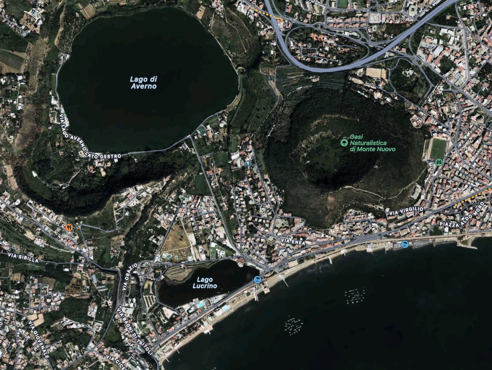
The map shows the current lay of the land. Lake Lucrino was well known in Roman times. It was separated from the sea by a sea wall and was used as a harbour. A canal ran to Lake Averno, and this lake at one time provided safe shelter for the Roman fleet. The outlines of the lake were changed by the new hill. The first vent was in the bay but avoided Lake Lucrino. It may have been south or southeast of Monte Nuova. That would put Tripergole underneath the southern side of Monte Nuova, and suggests the first rift extended between the summit and the sea.
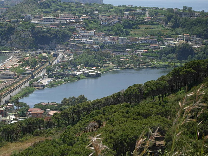
Lake Lucrino, seen from Monte Nuova
Eruption
At the start of the eruption, the plume rises to about 5 km high, producing smoke (both black and white), incandescent plumes, stones, a large amount of pumice and (notably) wet ash or even mud. The wetness was probably initially related to the marine eruption, and later to the pool that had formed at the location of the bulge during the few hours of inflation: it had a direct connection to a water reservoir. Boreholes have shown that the early ejecta were some 7 meters thick and were deposited mainly on the southern side of the current mountain: this may show the initial rifting from sea to shore.
The eruption causes chaos. To the south, the area is covered in the mud and large stones. A large amount of pumice collects in the Bay. Pozzuoli, to the east, also is covered in mud and smaller stones. After about an hour, Naples receives a covering, first from dry ‘sand’ and later from wet ash, at times almost liquid. A warm wind comes from the direction of Pozzuoli.
The eruption continues overnight. Pozzuoli is now covered in 25 cm of debris. Naples receives a few cm, with the fall-out becoming less wet during the night. The ash falls reach as far as 100 km to the east, blown by the westerly wind. Close to the eruption, cracks form in the ground, one of which runs to Lake Averno. Two warm springs form, one on the shore of Lake Averno and the other in between it and the main vent. The spring at the lake produces salty water, the other one fresh water. There may also have been a secondary eruption vent between Monte Nuova and Lake Averno.
During the day of Monday, Sept 30 and throughout the following night, the eruption continues with large explosions, expelling large stones and wet ash. People from Naples, always curious, try to see the new crater, but travel beyond Pozzuoli is impossible. We have several documents describing the events of this day. One of these is by Francesco del Nero, written on Sept 30. Del Nero was the brother-in-law of Niccolo Macchiavelli – but Macchiavelli’s Prince (“Everyone sees what you appear to be, few experience what you really are”) would have known better than to wake the dragon of Pozzuoli! By the end of the day, the new hill has reached a height of 140 meters. Reports describe that many birds are killed by the ash and sulphur.
On Tuesday, Oct 1, the eruption begins to grow less. For the next two days, the explosions lessen and the fall-out slowly ceases. This quietening phase is interrupted on Thursday Oct 3, when a large explosion occurs at around 3pm, dropping pumice as far away as 8km (based on a report from a ship at that distance). A new layer of 2-3 meters of grey ash is deposited on Monte Nuovo. Different from the previous ejecta, this ash is dry. Whatever water reservoir was interacting with the eruption has either run out or lost its connection to the mountain.
On Friday Oct 4, Francesco Marchesino visits the devastation in Pozzuoli. He reports “there were not ten houses…that were not either destroyed, or completely or partially ruined to the ground, and without a citizen and such was the devastation that not a single stone remained in the place where the master had placed it mason”. Half the Cathedral had collapsed and all the gardens were “covered in ash“.
October 5 and 6 continue the decline of the eruption. Naples being Naples, people flock in to see the new hill and to have a look in the mouth of the crater. The people scattered across the slopes are caught out by a sudden explosion, at 3 or 4pm in the afternoon. There are again reports of wet ash in the area, as far as Naples, but on Monte Nuovo this last layer has been found only on the southern slope where it reaches a thickness of 25 meters. This seems to have been a collapse event: the reports from Naples should be taken with caution. 24 people die, either from suffocation from the gas emissions or from the explosion itself. These are the only known fatalities of the eruption.
After this, there is no further activity. Smoke rises for a few weeks and abundant fumaroles deposit sulphur, but the eruption has now ended and the princess-dragon returned to her lair for a well-earned nap.
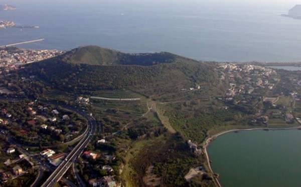
The new mountain
Afterwards
Although not a large eruption, it built a substantial hill. Monte Nuovo is 140 meters tall and covers a bit over 1 km2. The eruption volume was 0.05km3, a VEI-3. The eruption column may have reached around 5 km high. This would be a minor eruption in most places, especially in a location that had twice done a VEI-7. Indeed, it was a well observed curiosity but not something to panic a Neapolitan, although the locals suffered loss. The village of Tripergole was destroyed for ever and it is still buried under the mountain, but this was not seen as a great loss. It was just a part of life in Naples.
After the eruption, deflation set in. Over the next two years, Pozzuoli sank by some 6 meters while the shore near Monte Nuovo went down by a similar amount.
But it almost wasn’t the end. Trasati et al (2023, Geophysical Research Letters) present archeological evidence indicating that inflation resumed two years after the eruption. Over the next 40 years, Pozzuoli regained 1 meter in height, before deflation resumed. Models indicate that this inflation came from the same source (location and depth) as the inflation before 1536. Was magma still flowing in, and was this the onset of another eruption, but one that failed? Or was this just Campi Flegrei doing what it does best – changing elevation?
Magma sources
Where did the eruption come from? Models suggest that the post-1250 inflation had come from a magma reservoir located some 5 km deep in the Bay of Pozzuoli, south of the town. This may have been close to the centre of the NYT caldera. The volume of this intrusion was around 1 km3. The magma was not particularly hot, at some 840 C. In 1536, an intrusion occurred towards or under Monte Nuovo, at a depth of 3-4 km and with a volume of 0.3 km3. The rapid bulging before the eruption can be modeled as an intrusion of order 500 meters deep, of volume of 0.05km3. The eruption of wet ash suggests a significant amount of water may have been present at this depth. Studies of the crystallization of the ejected magma indicates that the ascent from 4 km to this 500-meter deep chamber occurred in only hours to days. The rapid bulging was caused by this ascent.
Source: Trasati et al. 2023. The circles show the location of the original magma chamber of 1250-1536
Lessons
It should be stressed how unusual this eruption was. The area had not erupted for 3000 years. The previous eruptions had come in phases, separated by decades, but this was a stand-alone eruption, a singular event. It was also on the small side: previous eruptions had ranged from 0.01-1 km3 and this one was closer to the lower limit (more like a Jabberwock than a full-framed dragon, perhaps). The feeding magma was also rather cool. Clearly, it was a marginal eruption. If the magma hadn’t found a route to Monte Nuovo, perhaps it would have given up and failed.
And, as in uffish thought he stood,
The Jabberwock, with eyes of flame,
Came whiffling through the tulgey wood,
And burbled as it came!
(Lewis Carroll: Jabberwocky)
The location was also slightly unusual. It was close to the original caldera rim and most eruptions here took place more than 5000 years ago. (However, the most recent eruption from neighbouring Lake Averno was also one of the youngest eruptions, dated to 3700 years ago. So one could also argue that with two of the most recent eruptions located here, and both being of similar (small) size, there is a pattern developing.)
A recurrence in the near future is therefore not too likely, at least if we only look at the two eruptions in the past 4000 years. But the activity in the region since 1960, with inflation, earthquake episodes and increased emissions at Solfatara may be a warning sign. Based on 1538, one could argue that an eruption in the next 300 years is not implausible. If the run-up to the 1538 eruption is typical, we would get much more warning than we have had so far, though, so anything in the next few years would be less likely. But we don’t know how typical this was.
Should we prepare for an eruption? (“How to train your dragon“?) The question becomes, for what precisely? Large or small? Where? During the unrest of the 1980’s, the population of Pozzuoli (72,000 people) was evacuated – but to a place also inside the Campi Flegrei caldera! That attitude to safety too is Naples.
We can probably assume that if something is brewing, there will be a few years of notice. The best thing to do is to already write the policy on how to handle such warning signs. Once the event begins, there will be too many competing interests to do anything. It is as with any crisis: action taken before it begins is much easier to implement. Once a crisis is developing, the main call will be to delay action. That is human nature: ask Machiavelli. (“How we live is so different from how we ought to live that he who studies what ought to be done rather than what is done will learn the way to his downfall rather than to his preservation.” ― Niccolo Machiavelli, The Prince.)
But remember that over 150,000 people live inside the caldera and a million people live within reach. If a Monte Nuovo eruption were to recur, the eruption would directly affect over 100,000 people and bury the houses of perhaps 10,000 of them. There is no such thing as a minor eruption inside a major city.
And there is one lesson everyone should take to heart. Don’t buy sea front property in Pozzuoli.
Endings
“Even dragons have their endings” (Tolkien, The Hobbit).
The best way to end is by re-telling Henrik’s vision of a future Campi Flegrei eruption, taken from https://www.volcanocafe.org/devil-may-care-campi-flegrei-ndvp-3/
It is a fine spring evening and tonight, Napoli are hosting AS Milan, a contest that will have a great bearing on the eventual destination of the Scudetto. It is also the run-up to the local elections and tonight, the Mayor entertains a very important gathering of political backers. Over at the Osservatorio Vesuviano INGV, the seismologist on duty is much alarmed by the series of earthquakes , apparently centred near Pianura, 10 km from the city centre and close to the margin of both the CI and NYT calderas. He calls the Direttore and by the time she arrives, the instruments indicate that the ground has begun to inflate, possibly as much as 50 cm as the instruments located at Solfatara, more than 4 km away, indicate 12 cm. The direttore immediately calls the Mayor but is told that he is unavailable. It is not until nearly midnight before she gets through to him.
Over at Stadio San Paolo, no-one has noticed anything as the greatest quakes were no more than M3.3 in strength and in any case, the Neapolitans are too exited. By the time the game ends, Napoli have won three goals to one and the streets are filled with a jubilant throng. Barring an improbable upset away at Siena, the Scudetto will return to Napoli!
Signor Sindaco is not best pleased by the call from Signora Direttori. He too, as well as his backers, is caught up in the jubilant mood and he has no time for unwanted news – it’s time to turn sporting success into political coin – and in any case, if we are to be honest, he is not fit to deal with serious matters effectively at present. He hangs up on the Direttore with the promise of a meeting at 10 a.m. next morning.
During the night, INGV staff have established that the ground is indeed inflating rapidly over a large area centred on the suburb of Pianura, that it inflates at a rate of almost 50 cm per hour which seems to be accelerating and that by four a.m., the ground has already risen more than four metres and it looks as if an eruption may be imminent. Armed with irrefutable data, the Direttore finally manages to get some response and together with the Chief Commissioner decides to begin an evacuation on their own initiative.
At 7 a.m., inflation stands at almost seven metres. Evacuation of the Pianura and Astroni suburbs has begun but it collides with the morning rush. In spite of the efforts of the Carabinieri, by 8 a.m. the roads in and out of Naples are completely congested. The Mayor, woken at five, has made a public appearance and urged calm as well as full compliance with the directions given by the Carabinieri, but few Neapolitans hear this. Most are on a high from last night’s victorious game against AS Milan and furious at the congestion of the traffic.
At 8:53 a.m. there is a series of large earthquakes that most people feel and three minutes later, an ominous cloud rises over where Parco Attianese used to be, one that resembles an acacia tree but is dark, grey, billowing and from which lightning bolts streak towards the ground. It is a cloud that rises higher and higher in the air as well as spreads rapidly in every direction with great walls of darkness through which a glow of lightning can occasionally be seen.
References
A description of the eruption can be found at
INGVI: https://ingvvulcani.com/2019/11/15/storia-del-monte-nuovo-lultima-eruzione-dei-campi-flegrei/
Details of the eruption used in this post are described in De Vito et al. Bulletin of Volcanology (1989), 49, 608 and in Guioboni and Ciucarelli Bulletin of Volcanology (2010) 73, 655
The magma system is described in Di Vito, et al., Sci Rep (2016) 6, 32245
Albert, October 2023


I believe the most recently imaged magma chamber was imaged just east of the old one, so it is possible the older chamber survived, with a few blobs to the west.
Regarding Henrik’s frightening tale/prophecy(?), what is now Diego Armando Maradona Stadium sits to the west of Naples, close to the site of Solfatara & Agnano where the most recent earthquake swarm has been and reportedly where magma is closest to the surface.
A cap rock will keep an eruption at bay for a while but anything that does come out will be forced explosively in a maar-like manner. The same is true of the ‘Roman cement’ in the harbour enfused with seawater, it will take a lot more force than has currently been seen before it is breached.
I expect that both the chamber underneath the Bay and 4 km below Mont Nuova survived, because the volume of the eruption was much less than the volume of these chambers. Whether they are active is a different question.
Thank you, a nice description of a Pumice Cone eruption, more viscous and gas rich than a cinder cone eruption, this Trachyte cone eruption is probaly very similar to the trachytic intracaldera holocene pumice cone forming eruptions inside Sete Cidades caldera at the Azores. Similar viscous magma and low temperatures, many pumice cones have a subplinian first stage and later viscous vulcanian blasts and pumice fountains and ends in extrusion of a lava dome in the vent when gas content have dropped to low. But what I have described here is more typical of historical Trachyte eruptions of Furnas and Sete Cidades, earlier larger Furnas tephra eruptions are probaly similar to the large tuff and pumice rings inside flegerian caldera
Indeed even a small eruption woud be a mess in a city as densely populated as this one is. Italy high density residental zones is a nightmare of narrow roads and passages, but its also very pretty there
I liked Naples a lot. It is a lively and in my experience, friendly city (don’t stay near the railway station though – that area is a bit run down). But you do wonder how they would cope with a real emergency.
I too likes the Mediterranean the stylish architecture, rugged limestone coasts and crystal clear blue waters and these creamy skies and surreal warm summer nights outside. All my best vacation memories in Europe been from the Mediterranean. But Mediterranean is also sunburnt and kind of dead in summer, but that blue water is stunning…
Their foods are also better in general than western europe, its less sugar and less ultra-refined carbohydrates, so less heart disease. Italian food items also even their processed ones have much higher quality, than many others similar products so are healthier than other similar wanna-be brands thats made in my country.
Its otherwordly beautyful really and specialy so Italy .. so No doubt that the Mediterranean it draws alot of tourists. My own homecountry needs to improve their archictecture, build more classical stuff instead of building our modernist bunkers thats sadely the mainstream in Scandinavian archictecture.
I woud be much happier in the Mediterranean than in this rainy drab place, but they dont speak english well and the summers are simply way way too hot. But ultimately Iceland is where I wants to be! It too is otherwordly beauty and I hopes to move there soon in the near future with my Nordic Citizenship, specialy now when Fagradalsfjall is in a rifting phase and may produce an fissure eruption every year or more for quite some time in the future. Iceland is insane scenery too
Apparently the magma of Monte Nuovo was K-phonolite, about 14% (Na,K)2O abd 59% SiO2. So it is very evolved but far from silicic, and was very crystal poor so probably was not a viscous magma. Although, it probably wasnt very fluid either.
Very potassic indeed, and the parent magma miles miles down is probaly some kind of basanite, which is the ancestors too of Vesuvian tephrites, Flegeri is very potassic and most of its magmas borders on Phonolites or are Phonolites, Vesuvious is tephrites, Tephrite-phonolites, some Vesuvian samples even broders on ”evolved foidolites” for Vesuvious to produce phonolite it haves to be dormant for a very long time so the magmas can get old.
Italian magmas are very alkaline and strange compared to other continetal rim volcanoes and things gets insanely strange when you get to Colli Albani that erupts insanely superalkaline Lecucites thats so gas rich they explode as soon as they reach the surface, Alban Hills are still alive in some geophysical studies any eruption there woud be insanely violent even the smaller ones been and woud destroy alot of towns, lecucites and melilitites are very fluid and haves an insane gas content. Campanian volcanic arc are strange and haves difftent melting conditions and potassic enrichment compared to other convergent volcanic lines, so alkaline they cool into syenites and ijolites so too alkaline for normal granite the plutonic stuff
The potassic nature of Italys volcanism also made their very nice concrete and richly carved italian trachyte Porphyry thats found in their palaces each object worth millions, Italy is famous for their porphyry and here in Scandinavia we have the infamed Älvdals Porphyry that was formed in catastrophic pyroclastic ingmigbrite eruptions 1,7 billion years ago some rich with melted pumicestones that adds value to the polished stone products, our own porphyry is as hard as saphire and is often ground down and used on winter roads in the northen parts of the country where the phenocrysts can resist the force of automobile steel spine tires
Phonolite is pretty lava knowing Erebus looks, the lava stone can have many colors, grey – green, grey blue, olive green, often in terms of grey but with these other tones and new spatter from the lava lake can look like dark pistasche 🙂 some other Phonolites examples in the world are just white pumice but that maybe due to light and bubbles in the glass froth
Just the 59% SiO2 alone would make its felsic equivalent mid-way into andesite which would have plenty of potential for violent results on its own.
And specialy so since ultra-alkaline lavas are very gas rich, and they dont get more Sio2 saturated than that as the base ancestral magma was already very sillica undersaturated at start.
Erebus is a super rare case of a degassing convecting Phonolite thats not blowing up, and shows that these magmas are indeed quite fluid But Erebus is probaly close to 1050 to 1100 c so is much hotter and so more fluid than most other Phonolite examples.
Erebus and Kilimanjaro are alkaline giants, when most souch magmas makes smaller volcanoes, Alban Hills is a Lecucitic giant ..most Lecucites are just explosive maars
Erebus is quite the rare unicorn even for the already quite rare phonolite volcanoes indeed.
Yes, Phonolite is kind of an outlier on the magma chart, because that chart mostly focusses on SiO2. By that logic phonolite would be intermediate, but it is as evolved from the base magma as rhyolite is from basalt, just in a different direction. I guess it is one of those things where evolved in the context of magma doesnt only apply in one direction, evolved magmas can still be very SiO2 poor relatively.
Trachyte, which is what a majority of Campi Flegri erupts, is properly silicic though, to a similar degree as dacite. But phonolite is actually more evolved than trachyte despite the low SiO2 in comparison. I remember seeing somewhere that phonolite can secondarily fractionate into trachyte and then rhyolite, maybe it was from Hector. But i dont know how important this process is, it would require a huge magma input without erupting beforehand which seems unlikely, maybe at the outskirts of a system but not as a primary function. There isnt
Not sure where the number of 840 C that the article gives for magma temperature comes from, it seems like an intrusion of trachyte began, and then settled in the upper crust where it lost its crystals and turned into a phonolite melt, or perhaps was already a phonolite melt with less alkaline crystals. Either way that settled melt was what erupted at Monte Nuovo. Hot silicic magma especially if it is highly alkaline is not as viscous as it is often described, only crystal mush erupting directly makes huge domes etc otherwise you get sticky but mobile lava. The settling out probably could have happened in the couple decades before the eruption easily.
I guess now we just need to find if there is something similar going on now. As the article describes Monte Nuovo was weird in being isolated, when the previous eruptions were frequent in the span of a few millennia. That being said, it isnt impossible for gaps of 500 years between even then, just that there were also gaps of much less to even out the average.
“I remember seeing somewhere that phonolite can secondarily fractionate into trachyte and then rhyolite”.
I used to think this, but it turns out it’s more complicated, something related to ratios of potassium vs sodium. Within volcanoes of similar alkalinity, for highly evolved magmas, there seems to be an inverse correlation between sodium and potassium. In Italy, most volcanoes have a potassium-rich sodium-poor composition. The volcanoes themselves vary and they form a trend from more sodic compositions and potassic compositions. Ischia, Campi Flegrei, and Sabatini-Vulsini-Vico have the same alkalinity (similar to the Canary Islands), but increase potassium and decrease sodium in the same order that I listed them, although all of them would be on the potassic side. If you plot them in K2O vs Na2O plots they make a chain from the Roman volcanoes to the sodic Canary Islands, which seems to mark a particular level of alkalinity but with changing levels of potassium vs sodium. Pantelleria has a milder alkalinity and is the only sodic caldera in Italy (similar composition to Ethiopian calderas). Vulcano is the same alkalinity as Pantelleria but potassic. Vesuvius is more alkaline than the aforementioned calderas (comparable to Cape Verde’s alkalinity) and in the sodium vs potassium range occupies the whole spectrum spanned by Ischia and Campi Flegrei. Colli Albani is difficult to compare because it doesn’t have fully evolved magmas like the others, although I think it is similarly potassic to the Roman calderas, and as alkaline or more than Vesuvius.
However, the sodic magmas are higher in total alkalis than the potassic ones and a little poorer in silica, so they plot in different parts of a TAS diagram. At Campi Flegrei which has a big range of compositions, the more sodic magmas plot in the phonolite field, and the more potassic ones in the trachyte field. So it is not that they have evolved from phonolite to trachyte or that they have different alkalinity, but that they represent two different compositions with either different origins or different paths that they have followed. Monte Nuovo represents a very rare sodic endmember of Campi Flegrei, most eruptions of Campi Flegrei are closer to the potassic endmember, the Neapolitan Yellow Tuff is also on the potassic side, while the Campanian Ignimbrite covered almost the whole spectrum of the caldera reaching to most potassic compositions ever erupted by Campi Flegrei but didn’t reach to the sodic endmember of Monte Nuovo.
Thanks Albert for this fun description of the Monte Nuovo eruption. Let’s hope Ancalagon doesn’t wake up any time soon.
The eruptive history of Campi Flegrei is still being explored, apparently, some big eruptions have been discovered recently. First, the Masseria del Monte Tuff, 29,000 years ago, which is thought to have erupted ∼16 km3 dense rock equivalent, it was a plinian eruption and not an ignimbrite eruption:
https://pubs.geoscienceworld.org/gsa/geology/article-abstract/47/7/595/570173/Evidence-for-a-large-magnitude-eruption-from-Campi
Then five huge explosive eruptions between 92,000 and 109,000 years ago have been found to come from Campi Flegrei. Two of the events were strong enough to rain ash in Greece; the 92,000 BP Triflisco unit, and the 109,000 BP Maddaloni unit. And another eruption deposited ash in the Balkans. The Maddaloni eruption tephra is much thicker than the Campanian Ignimbrite in a lake 120 km away, and has the second largest dispersal of any CF eruption after the Campanian Ignimbrite. PDF of the article:
https://cronfa.swan.ac.uk/Record/cronfa59518/Download/59518__22539__00aa3dfc98fd4a38a7a4cf47718418d0.pdf
It is an interesting neighbourhood with the “New Mountain” (Monte Nuovo) next to the “New City” (Neapolis).
Monte Nuovo was a phreatomagmatic eruptions. Are other types of phreatomagmatic eruptions common there? F.e. Maar euprions, Surtseyan eruptions, phreato-vulcanian/plinian eruptions.
Monte Nuovo was Italy’s Paricutín: A monogenetic volcano that rises from zero to a strombolian cone. Compared with Paricutin Monte Nuovo was both small and short. Paricutin erupted for 9 years, while Monte Nuovo had a short life of 7 days. A Maar eruption – that is another possible eruption type there – would be much more dangerous and explosive.
Monte Nuovo is famous for its location and that it’s the only historical eruption of Campi Flegrei. The eruption had a big social impact. It hit a dense populated area (unlike a remote Alaska eruption of similar size). It showed that also during Middle Ages the human fascination for volcanism was vital. To be challenged by the danger of fire and to deal with it savely, is a general human passion that also helped to develop all kinds of skills to use fire (like furnace, charcoal burning, blacksmith).
Monte Nuovo happened during a dormant phase of Vesuvius. But during the long dormant phase previous to Plinian’s Vesuivus eruption 79AD there were no eruptions at Campi Flegrei.
As a fan of the football club in Naples (Forza Napoli!), it’s sad knowing our stadium and such a beautiful city can be ruined by an impending eruption.
At the same time, it’s fascinating to see how the city has developed around its volcanic landlords over millennia and endured the rising and falling land, the lava, and the ash. Humans are astoundingly determined to live in dangerous places.
Thank you, Albert. Fascinating knowing more about this restless giant.
I have a look on Google Maps at the waterfront around the bay. It is interesting to see remnants of housing under the waters, and a lot of very large blocks of rock, too.
“I have a look…” Oh dear. “I had a look…”
That is ok. It is not like you are a librarian. Anyway, I switched between tenses in the post too
I was a librarian before I retired!
The colonization of Nyiragongos 2021 lava flows have already began, seeing sizable bushes from FB videos from ”congo tourism gate” page from videos posted already october 2022, in the wet tropics and with souch potassic chemistry plants move in quickly, and explains why the 1977 and 2002 flows are pretty much gone by now, and their lower parts been removed by humans, quarried, the flows probaly weather quickly at least the surfaces, weathering is indeed fast in tropics and toprocks decompose into red oxidised soils
In the meantime Nyiramuragira haves some intense lava lake activity, possible pahoehoe fillings of the caldera, there is lots of vog in satelite images and not strange as it is an incredibley powerful volcano, its one of the most powerful of all continetal volcanoes at current on the planet and maybe the most powerful land one, Erta Ale is also powerful as well, but Nyiramuragira is more so, Nyiramuragira is noteworthy for its alkaline productivity when most other basanite – tephrite volcanoes are monogenetic cinder cones. Nyiragongo and Nyiramuragira must be what most people imagine a volcano should be like – deadly gas pockets, hot fast lava, a lava lake, and a beautiful steep conical profile rising out of the jungle. Its fiery glow casts an eery shine over the night jungle far far away in a ”dark, poorly known” mysterious land. It is as stereotypical as a volcano can be on Earth. It is just like every child imagines what an active volcano would look like.
https://apps.sentinel-hub.com/sentinel-playground/?source=S2L2A&lat=-1.3995876582668811&lng=29.183807373046875&zoom=11&preset=1_TRUE_COLOR&layers=B01,B02,B03&maxcc=20&gain=1.0&gamma=1.0&time=2023-04-01%7C2023-10-14&atmFilter=&showDates=false
A living tree If this photo pops up ( confirmed by the source ) with a big spatter bomb from 2002 upper fissures at Nyiragongo. The trees high water content and high heat capacity and very low conductivity is what saved it from death. Many other trees where covered in sheets of lava and killed.
Excellent! I wish I had had these visuals when I was in that region in June 2022. Hiked Vesuvius nevertheless.
Naples got covered in cement! A pozzolan is a cement base mineral, and is named for Pozzuoli. The Roman Empire was literally built with tuff from Campi Flegrei.
Meanwhile the dragon is stirring sleepily…
The European city at risk of a supervolcano eruption as it is shaken by daily earthquakes (3 Oct)
Whether he’s clearing his throat, or just snoring louder than usual, we will see.
You need to mix it with sand and lime to make it proper cement. But yes 🙂
I find it strange how so many people think we dont know how Roman concrete was made, or that it was somehow better than the stuff we can make today. Same as Damascus steel, by todays standards its pretty average carbon steel. What is mysterious is how someone figured out how to make those things millennia ago not the material itself.
Tip: If you want to locate quickly those Roman pillars on the Google Maps, search for “Macellum Temple of Serapis”.
Thanks for the article, Albert!
The role water plays in the rather fast uplift is curious.
“The underground water that is causing (some of) this has two origins. There is water present at a depth of 2 km which comes from the Bay of Pozzuoli, while another water reservoir at 8 km depth is much older and is associated with a magma reservoir. The 2-km layer is associated with a cap rock which is poorly permeable, so that water can collect below it. The fast episodes of the 1960’s and 1980’s were related to changes in the shallow reservoir. The slower changes over the past two decades come from the deeper one.”
Do you know/is there documentation available about how such fast movement of water that deep under surface is possible? The water content must be enormous….
Are there other volcanoes known interacting with deep water reservoirs like Campi Flegrei?
It is complicated and I didn’t fully follow the papers. There is agreement on the shallow water reservoir. Below that, people quote different depths and perhaps the best way to summarise is that there is ‘meteoric’ (percolating down) water below 2 km, and water dissolved from magma at 8 km depth, where the two interact and mingle. The changes are caused by ‘movement of hydrothermal fluids’, i.e. water heated by the magma and convecting up. There is currently no convincing evidence for shallow magma being emplaced. Water, of course, moves around and up far more easily than magma, so can cause much faster and larger changes. Magma requires overpressure to rise – water doesn’t. But do correct me if this picture is wrong!
Water doesn’t need to be pressurized to rise. But it will be pressurized, while it is heated.
Interesting that it can cause so much uplift. Could bentonite or something like it help to expand?
To get the usual meters of uplift and downward motion in calderas requires water. Yellowstone is an example. It goes with fumaroles and geysers, so there is no doubt that water is circulating. The large uplift in the 1538 eruption (10 meters, perhaps?) within 48 hours is more difficult to envisage, and since it did initiate an eruption, it was more than just rising water. But water was part of it, as shown by the fact that water appeared just before the eruption, and by the wet almost liquid ash. The rise must have come from fluid migrating rapidly from a few kilometre to very shallow: that gives inflation in a very localised area. How much magma rose at the same time is more difficult. Was it 80% water and 20% magma or the other way around? Note that the eruption started with fire. There is no report of lava flows but the explosions involved magma. It is complicated..but water was involved at most stages.
Water does not expand that much when heated (neither does magma). You get inflation though when it rises because its volume act on a smaller region. To get real volume increase you need to release water from magma, or turn some into gas.
Thank you Albert! 🙂
Looks like the show is over for now 🙁
Although, even over an area of maybe 100 km2 that was affected by some form of uplift, 10 cm uplift is only about 10 million m3 that moved into the rift to cause all this. At present supply that is probably only a few weeks off, an eruption after that is not unlikely to occur in short order.
It seems that at least for Kilauea unless an intrusion is a rock breaking event, of which the majority of which seem to result in some sort of eruption, then it isnt doing anhthing to remove pressure. The above number of 10 million m3 was assuming 10 cm uplift all iver when it was only that high at peak. Most probably the real number is half that. 4 million m3 in the time this swarm went on is not even really above the supply rate, which fits to there being no deflation at the summit. To me it looks like the volcano has just confirmed my suspicion that the SWRZ is activating, it could have kept erupting in September but it didnt, then weeks later starts pushing magma into the SWRZ connector area. There is a DI event ongoing now so will be interesting if maybe I jumped at calling this over too soon.
As far as I can tell, the 10-cm uplift is only seen in an area of a few kilometre across. If anything, you number of the intruded volume is too high.
Thats what I said in the second part, that the 10 cm is the middle not all of it. I halved it and then went down even a bit more to get to 4 million. That number over the course of a week is about 6.5 m3/s supply which is not really outside the range of supply rate that is going on right now, it is elevated compared to before. If it was 10 m3/s though that is probably still too high even now, then that would probably cause some degree of deflation at the summit that wasnt observed.
Yeah, if you model the inflation as a dome, it works out to slightly over 4 million m^3
What’s happening with Tambora?
https://www.volcanodiscovery.com/earthquakes-volcanoes/past24hours.html
Thanks Albert for this article. It’s been a pleasure to read it
The only thing I would like to suggest, though, is a change from “Monte Nuova” to “Monte Nuovo”. “Nuova” is a feminine adjective that according to Italian grammar needs to agree with its noun. “Monte” is a masculine noun and requires a masculine adjective, which is “Nuovo”. Sorry for being pedantic, but your article is so well written and needs just a little adjustment.
Thank you for this! I’ll fix this: the comment is much appreciated and always happy to learn. I did envisage the dragon of Campi Flegrei as being female, but that was only because of the sleeping beauty storyline.
Meanwhile a 3.6M a couple of hours ago in Campi Flegrei.
Is there any more information on this earthquake?
need translate italian
https://twitter.com/INGVvulcani/status/1713875059427664075
depth 1.9 km, in Solfatara; then only little quakes… now it’s quiet, the dragon is sleeping
Its looking like a new intrusion on Reykjanes could be imminent. There is significant uplift compared to earlier gaps in activity, even official word seems to be that an eruption before the years end is not unexpected.
I read somewhere that the last few eruptions have been identical to the lava erupted in the seco d half of the 2021 eruption but different to the start of 2021, and that both are highly distinctve among Holocene lavas on Reykjanes. It was interpreted as a common deep source with no new input. The degree of inflation at Fagradalsfjall now would suggest maybe the latter part of that isnt true anymore if it ever was… there isnt going to be a Laki or anything like that, but I cant help but think the capabilities of the system have been greatly underestimated by the recent activity and that way faster eruptions will soon happen.
It is something worth mentioning, but if Fagradalsfjall does rift like Krysuvik later on and engage in curtain of fire style eruptions, then following the fissure swarm goes directly into Reykjavik. Just saying…
It’s looking promising. Not so sure it would go into Reykjavik, itself, but it could be close enough to cause disruption and take out the road to airport, should the fissure extend that far.
More referring to all of that rifted terrain just inland of Reykjavik, thats all part of Krysuvik. Eruptions mostly havent happened there in the Holocene but rifting and intrusions evidently do, which would make sense looking at other rifts we have seen forming recently elsewhere. Fagradalsfjall hasnt done this in the Holocene but then it also has only one other eruption on it in the Holocene too and it is not certain from the vent location that it wasnt just a weirdly located vent if neighboring Svartsengi, than the same system at present.
But yeah, a big rift that goes way past Keilir would potentially go under Reykjavik, or at least to Hafnarfjordur. Not a likely event but not something to be ignired either at this point.
Meanwhile, there was a fourth 6.3 in devastating sequence in Herat, Afghanistan.
Quadruplet being exceedingly rare, here are some interesting comments:
https://earthquakeinsights.substack.com/p/fourth-m63-earthquake-strikes-afghanistan
https://twitter.com/RLacassin/status/1713500425448464583
It cannot be ruled out that the next eruption does not follow the same pattern as Monte Nuovo, the more large earthquakes happen the more potential there is for a rupture of the cap rock in the Antininia region. There would still be some warning, but it could come suddenly and ferociously – a real dragon-esque display of angry fire.
If we compare it with the current situation, now the swarm appears around 4km to the east of Monte Nuovo. It is a different place. The small distance from Monte Nuovo may lead to very different behaviour in case of a future eruption (either near 2024 or distant f.e. 2204).
The present swarm accumulates at Campi Flegrei Crater, where eruption no. 31 is place in the second map of this Article. What do we know about the eruptions on this location?
Kilauea’s SWRZ crisis is back. There have been more inflation and earthquakes since yesterday, more or less coincident with the end of a 3-day-long deep DI event. Interestingly it looks like the area where the Kamakaia Hills dikes start, the lower portion of the connector, has been slightly more active than the middle portion, while the upper portion of the connector seems relatively inactive. So earthquakes have been shifting along the connector since late August, first the upper part, then the middle, and now it looks like the lower section is the focus.
There seems to be trace quakes along the very uppermost part of the ERZ connector too, at least that is what it looks like in the map. Its not enough to indicate anything imminent there but I remember seeing this before the last eruption too, I think it is showing pressure. There is also more quakes in the caldera too, also not in actually large numbers but compared to their almost total lack before it is interesting.
It seems like this event, whatever it is, is caused by slow intrusion of magma into the connector being fed more or less at the base supply rate. That is significant, as it probably means the summit has reached max capacity, even though the lava level there is lower than in 2018. It is quite likely the next eruption will be on the SWRZ, which part of it will remain to be seen.
Lava is filling Nyiragongos summit crater again, looks alot like the 1980 s and 1990 s temporary activity, it came to life rather quickly after 2021 drainout. This does not look like to be an open conduit lava lake that circulates, its just lava filling the crater floor. But it does have filled quite alot the 2003 – 2021 lava lake was this high in 2010, so been probaly filling faster than then previous lava lake did on avarge, the higher it fills the more likey the magma column is to rupture due to pressure its putting around it.
Nyiragongo is a small volcano, althrough its pretty powerful for its small size and haves a high heat output, the magma supply is probaly little above avarge now as it came back so quickly.
https://apps.sentinel-hub.com/sentinel-playground/?source=S2L2A&lat=-1.5211273164375816&lng=29.2606258392334&zoom=14&preset=6_SWIR&layers=B01,B02,B03&maxcc=4&gain=1.0&gamma=1.0&time=2023-04-01%7C2023-10-17&atmFilter=&showDates=false
It filled up fast in the 1980s and 1990s eruptions too, faster than the yearly average after 2002. Seems that maybe a similar situation to Kilauea in 2021 is going on, where the initial filling of the 2018 caldera was extremely fast, but nowdays the new eruptions barely add anything. Nyiragongo is smaller and steeper so the same rate of filling will be faster to actually fill up the crater though.
Its very interesting really, before 1977 there was maby decades of lake activity and filling, at least 50 years and maybe several decades more. But after 1977 there have been drainouts more or less every 20 years since, and the lake has filled to not quite as high but much more rapidly. Maybe it has got a magma supply cycle, possibly rifting related. Or maybe it interacts with Nyamuragira somehow although it doesnt seem to be the same sort of alternation that Kilauea and Mauna Loa have.
It is still very interesting, Nyiragongo has probably changed its behavior significabtly in the recent past, from a fire fountain volcano to what it is now. The flows are greened over rapidly so that big flow on the east side of the volcano still being visible in the landscape is suspicious, it might have been the last drainout before 1977, maybe back in the 19th century between written records. Certainly the reputation of Nyiragongo seems to be a lot older than the 20th century.
Beautyful activity, with a central salmon deep orange dome fountain with bursts, sending lava waves under a dark thin fissured crust, fissures bop and heave as each wave passes through the pond. Above the fountain vent is thick steam that sometimes hides it and dark spatter pieces sometimes fall.. sometimes fluid ribbons are thrown out that cool and breaks into fragments as they are thrown out, sometimes near yellow part are seen in the dome fountain, each bursts of spatter forms a wave
The lava crust is dark and glossy.. clearly without Hawaiis shine althrough still very fluid and smooth.. with radiating deep orange zig zag fissures that constantly flex 🙂 up and down as sourges comes from the central fountain, fluid waves wash on firey shores, each wave comming from the central fountain upwelling licks the edges with deep saturated salmon hot orange, that leaves a glowing thin veneer on the walls that quickly fade away.
At night its even more intense looking like a iron foundry…
Highly alkaline fluid lavas are beautyful looking ..
Weird that Nyiragongo and Nyiramuragira haves so diffrent magmas despite being close to eachother, Nyiramuragira is a tephrite so a sligthly evolved basanite, and the nearby Nyiragongo is an even much more undersaturated Nephelinite. Nyiramuragira is more crystal rich too being more evolved.
Nyiragongo probaly haves much deeper and smaller partial melting as source, its still incredibley productive for being a Nephelinitic volcano when most other souch composition volcanoes are simply monogenetic cones, so Nyiragongo is probaly quite large melt rates anyway, just very very deep down under high pressure in a metasomatic carbonated mantle to form these highly undersaturated magmas.
Nyiramuragira is the most powerful magma source of the two.. being shallower mantle melting of sligthly larger ammounts. Both volcanoes probaly haves a very large powerful supply deep down.. so yes not all highly alkaline volcanoes are weak, these two volcanoes are proof that highly alkaline volcanoes can be very powerful and are the most powerful volcanoes of each magma composition now on this planet. Nyiramuragira is probaly capable of flank eruptions of multiple km3 knowing how large its summit caldera is, making them giants among alkaline productivity.
https://m.youtube.com/watch?v=tRwqdvXMusU
08:15 – 08:25 the birth of the 2002 – 2021 Nyiragongo lava lake was insane stuff, I never seen any other lava lake recorded being this violent, the gas content is tremedous to make a magma column behave like this, easy explains the giant pyrocumulus steam column that hanged over Nyiragongo during the first lava lake years after 2002. Woud be an ideal place to film the Sammath Naur scene in Return Of The King at least use recorded footage and paste that into CGI enviroment 🙂
https://archive.org/details/H_Tazieff_raconte_sa_Terre_1984/H.+Tazieff+raconte+sa+Terre.+6-+Haroun+Tazieff+et+les+volcans%2C+premiere+partie.mp4
And some older videos of the 1977 lava lake
https://archive.org/details/H_Tazieff_raconte_sa_Terre_1984/H.+Tazieff+raconte+sa+Terre.+7-+Haroun+Tazieff+et+les+volcans%2C+derniere+partie.mp4
51:25 – 55:05
Very nice recordings showing how low Nyiragongos viscosity is, from the early 1980 s activity, similar to Halema’uma’u in 1966
Images of Io from the recent flyby are being released
Lei Kung Fluctus lava field the large one there, looks competely unchanged.. we will have to wait until the winter flybys, one that will go as close as 1500 km from Io for better images of the surface, this also images areas that Galileo did not image very well
Isum volcano just below it looks unchanged too, but other areas on Io ( unseen ) have had MASSIVE eruptions since the 2000 s and will be major resurfacing. Will also be fun to see If we can get a look at the Prometheous, and Amirani pahoehoe lava flows and see how much they changed in over 20 years as they are still active in other thermal data imagery
We will have to wait until january
Pillan Patera woud be fun to If we can get a New look at it… it too have had massive eruptions .. in recent past and many since 1997 and 2015 was very large
There are higher resolution images released, but I liked this one. But don’t expect too detailed images. Juno only has a limited camera
The winter flybys will be much closer .. and should be able to get some really good shots.. at least much better than now
In December we will get much closer to Io and much better photos
Next in December at it will be much closer and later one again in January I think
What do we know about the linkage between Ischia/Procida, Vesuvius and Campi Flegrei? Do they sit in the same graben?
There has been some evidence (partial, not full) for volcanoes that grow from the same deep magmatic source; Kirishima & Aira, Sinabung & Toba; Mount Cameroon & Tombel/Oku
We know that Ischia has been steadily inflating for a long time for instance
It is a separate volcano, about as far from Scampi Flegrei as is Vesuvius. It is sitting in the same wide graben but has a separate feed and history. A new eruption would not be impossible: it mainly does small eruptions, the last one around 1300.
Scampi Flegrei is pretty funny, some shrimp might be cooked at one point…
yum
I love shrimp too
New webcam covering the SWRZ and Kaʻū Desert:
https://www.usgs.gov/observatories/hvo/s2cam-kilaueas-upper-southwest-rift-zone-looking-southwest
I made a short video about our trip to Iceland: https://youtu.be/DQr_Ssl-Blk
we hiked from Thorsmörk to Landmannalaugar, sadly my action cam got lost, so not a lot of footage of the first two days. Some footage might be of interest to VolcanoCafe readers, Torfajokull, Landmannalaugar, etc.
Amazing video astro, would definitely watch more 😀
Thank you for the kind words!
Wonder what’s the deal with the two quakes around Puhimau Carter? It is basically on the outermost ring fault…
Possibly earthquakes along the ERZ conduit/connector/deep rift, which has been seeing some weak activity lately.
Honestly, people, you must be nerds or crazy. Coming back from France there were about 20 police on the Austrian border to Germany, France is on “Emergency Attack Level”, there were murders in Amiens and Brussels besides Uganda, threats again several airports in France: Rishi Sunak and the American Pres. are trying to mediate in the Middle East, China and Russia do not condemn Hams for genocide and seeking their advantage for Taiwan/Ukraine, and we are on the brink od WWIII, and you discuss s.th. that won’t happen at the moment (Campi) or alternatively your darling Kilauea. Mankind is the enemy.
Go on like that, it is cute, but some words to that planned genocide about ten days ago wouldn’t be wrong. Volcanoes are our friends. They give us soil and food. If they erupt and damage people they hadn’t planned it, and they are pretty. What’s going on in world politics is not pretty at all.
You must be living on islands. and you are.
1. Albert, Island of Albion
2. Jesper, Island of Io
3. Chad, Island of Australia and Big Island.
4. Héctor, Big Island
Go on. It is good, it is deviating. But keep in mind, that volcanoes are our friends, and that we are now all maximally endangered because a terror group began a barbarism which was finished for a while in 1945. Forgive me. I am absolutely taken down by the fact that we are living among much bigger monsters than Taupo or Campi Flegrei. I am devastated about what seemingly human beings can do to people, esp. women (rape and murder or abduction) and children because they happen to be Jewish. I am totally devastated, dass das hier keine Sau interessiert, weil Kilauea so wichtig ist. Und jetzt habe ich mal die Sau rausgelassen. Das kann außer mir nur Carl.
You can take this out dragons in case it is too much fury. It is pretty volcanic.
corr. against several airports, The a in the org. was left out on purpose
If the world is going to end then nothing said here matters to that. Why bring it here when most of us are here to get a little escape from that reality, not because we are unaware.
And volcanoes are not our friends. The Hawaiians didnt see Pele as their guardian, rather as the creator who could also take away, which is no less relevant today as it was 500 years ago as was so poignantly demonstrated in 2018. They are a part of the world we live on, and one of the only things we have no means to control. We live on their slopes to inprove productivity in agriculture but it is a great gamble.
That was an unnecessarily personal attack, Denaliwatch. Yes there are bad things going on in the world, and everyone feels bad about it. But this is a forum for volcano related badness not people related. Just because it’s not mentioned here doesn’t mean people don’t care. And what impact would your comment have if someone reading this has family or friends involved?
To everyone mentioned in Denaliwatchs post (and anyone else reading) please don’t take it personally. There are people here who value the non political chat here because we can find plenty of that elsewhere.
Dragons, this chain of messages should probably be removed as being off topic.
Thanks Eolienne, you expressed my thoughts/feelings very well.
One of values of this blog I like so much, is that it is about volcanoes and non political.
Please let it be this way. 🙂
This blog is about what brings us together, not what sets us apart. We have learned that interest in all things volcanic is completely separate from political or other opinions. We have people from the left and from the right of the political spectrum, from religious and atheist persuasions, and from the western and non-western world (although the comments are mainly western, our readership is more diverse). World events do get mentioned but they are not what this blog is about.
This does not mean that our commenters and readers are not affected. We do feel for each other. This was the largest terrorist atrocity for 20 years. We have readers fighting in wars, past and present. Where I live in Manchester, we had a suicide bomber attacking a children’s concert. I did mention this here but did not expect comments on it. And it is not only the big things. Many of us will have experienced personal tragedies. Commenting on VC does not deny this human world, but our focus is the other world out there. So are we an island? Perhaps our role is that of a safe zone for people. When covid reigned (three people I know died of it), we put out a light-hearted April-1 post. That seemed appreciated. For terrorism and wars, though, that is not an option.
Volcanoes are not really our friends (they are more like sharks in that respect). We are well aware that we are enjoying something that also causes suffering. But they are not our enemy either. They are what they are. VC is about our interest in that other world.
Thank you Albert, also Chad. It wasn’t meant as a personal attack. Some words are important at times:
“This does not mean that our commenters and readers are not affected. We do feel for each other. This was the largest terrorist atrocity for 20 years.” Thanks.
It wasn’t only the largest terrorist attack. It was the largest pogrom against Jews since the “Reichskristallnacht” 1938 (leaving the Holocaust out being state-organized industrial slaughtering). Some can’t see that not being from Europe, esp. Germany, France or the Netherlands and being younger. It is the same mentality.
Btw, Eolienne, wake-up calls and criticism are no attacks. When people get bored if I talk too long about beloved Earth I declare that I am a nerd of Plate Tectonics. So never mind.
I offered to take the comment out, but it staid. Thanks, Albert, Carl, dragons, VC. Great minds. And: “Great minds don’t think alike”, book, Emily Gosling. Debate is important.
There are way more reasons Hamas is attacking Israel than just because the majority of Israelis are Jewish, the Palestinians are not evil even if the local government is a terrorist organisation. That is probably a part of it but to pin this as just an act of racist (religist?) terrorism is not honest to the reality. Israel has got its own long list of very questionable activities they have comitted against the Palestinians especially those in the Gaza strip, which is mostly protected by the West and especially the US in their own interests of having power in the area.
Neither sides government is innocent, Hamas is a terrorist organisation and deserves their title, but Israel is a US puppet to project power and they dominate the area. Only the civilians who are caught among it are the victims as is the case for every war.
Really probably just a good idea if one of the admins coudl delete all of this, its not really relevant to this forum and most people here probably want an escape from reality not an excust to talk about it internationally, there are other forums for that.
I understand and will cut you some slack. For those unfamiliar if you are Jewish or have family that are this is devastating and as it dominates the news it becomes more terrifying by the hour so not a surprise when one becomes overwhelmed. Please take into consideration the tension that has accumulated at least here in the US. Over the years my granddaughters have been bullied due to heritage and now their parents have told them not to mention their heritage for now. I tell you this so that you can forgive a moment of frustration as I think we are all concerned and understand
They are both digging their own graves on both sides as Chad says, and often its the fundamentalist part that cause the most suffering for normal citizens in both sides. They most violent factions are also trying to make each side s side look bad as bas as possible in the media causing even more confusion and suffering. Its one big tar bath for everyone in there on both sides
Volcanoes allow us to get a break from human madness … and all kinds of civilization stress
Volcanoes are a threat, but more friendly and often more reliable threat than human violence.
Politics and religions easily mobilize humans’ passions and emotions. Therefore it’s always risky to debate about them. Added to this the digital world makes it even more difficult to talk in a personally appropriate way.
Just giving up on you Chad. Just in case you want to read up:
When Husseini eventually met with Hitler and Ribbentrop in 1941, he assured Hitler that “The Arabs were Germany’s natural friends because they had the same enemies… namely the English, the Jews, and the Communists”. Hitler was pleased with him, considering him “the principal actor in the Middle East” and an Aryan because of al-Hussaini’s fair skin, blond hair and blue eyes.
https://en.wikipedia.org/wiki/Amin_al-Husseini
https://en.wikipedia.org/wiki/Relations_between_Nazi_Germany_and_the_Arab_world
https://en.wikipedia.org/wiki/List_of_massacres_in_Israel
Hamas is a branch of the Muslim Brotherhood, btw., founded by Hassan al-Banna and Qutb, the inspirators of bin Laden.
Be all of that as it may, none of it justifies the forced relocation and murder of children, nor the bombing of a hospital, nor … well, let’s just say that the list goes on.
Two wrongs don’t make a right.
Uh-huh.
Careful what you think. When the Germans decided to change their mind, 6 Mio were dead.
“The Covenant proclaims that Israel will exist until Islam obliterates it, and jihad against Jews is required until Judgement Day. Compromise over the land is forbidden. The documents promote holy war as divinely ordained, reject political solutions, and call for instilling these views in children.
The updated 2017 charter attempts to moderate Hamas’s image by stating that Hamas is not anti-Jewish but anti-Zionist, but retains the goal of completely eliminating Israel.”
https://en.wikipedia.org/wiki/Hamas_Charter
Whatever opinion we may hold, the simple truth is peace is impossible while Hamas exists.
The point I am making is in the modern day war is not the same as it was, and if you think I am antisemetic just because I dont wholehardedly support Israel in this then it is you who has the narrow mindset, two wrongs dont make a right and if you dont want to understand what I mean when I say that dont bring up controversial topics when other peoples opinion may differ.
It is off topic but it also something that is affecting people badly. We ban or delete posts that are insulting or discriminatory, or incendiary. We don’t ban people from telling us about what is affecting them personally, such as stories like Ellen’s.
The Middle East is not a problem that we are going to solve here, though.
Mind you, some of the political catastrophes do show the logistical nightmare of evacuating a large population in a short timeframe. If Campi Flegrii were to wake up…
What they also highlight is the speed problem in particular.
Armies move at a certain pace. Even though modern mechanised forces can go very quickly in short bursts they always outrun their logistical tail within a few days.
An army will never go 50 to 100 miles in a few minutes. A pyroclastic flow from a big eruption on the other hand WILL do that. Hence by the time a big eruption starts it being far too late to escape if nearby.
Right. An evacuation in a worst case scenario at Campi Flegrei or alternatively in Tokyo is practically impossible.
Anarchy will likely be seen, could be worse than the actual eruption. Can you imagine if it decides not to erupt at the last minute?!
Bit of a pickup in deep quakes in the Pahala area. The shallow swarm seems to have paused again though, interesting what is going on there, maybe it is somehow related to the same mechanism as the DI events although no such signal appears on the instruments this time.
It was mentioned on the HVERI/HawaiiPODD livestream today that the deep sills under Pahala are as much as a couple hundred meters thick particularly closer to Kilauea. The fact it is a compact structure also probably means this isnt crystal mush but concentrated melt and a lot if it. Not that it is going to go off necessarily but if these structures are novel and relatively young then that does suggest an eruption that is well outside the standard activity is possible. It might be impossible to know how old this area is though, only that it is older than thr 1970s but really picked up 4 years ago.
Still, I cant help but wonder. The sheer uptick after 2018 to me looks like that is when the sills began to form, especially the area closer to Kilauea and east of Pahala itself, that was entirely absent before this time and has the largest structure in the quake plot from the 2022 paper. A magma body separating from crystals to make a melt rich magma body is exactly what would probably set off an eruption were it shallower. The sills contain tens of km3 if magma, which has only organised in the past 5 years, if only a few % of that makes a run for the surface at either volcano things could get pretty scary.
Shallow earthquakes have decreased. Is it the quiet before next storm?
A big green blob has appear. In my highly unscientific observation in recent times the green band depth is very quiet with earthquakes. They seemed to appear around the time of eruptions….so maybe. Will be watching out the next few days.
Green band is usually free yes, maybe there are not many faults at that depth. Not sure if they are reliable indicators of eruptions but there have been a number of these strong green quakes around Kilauea when it is strongly inflating. But this is the first quake in a while under its SWRZ that is in this intermediate area. By itself it is probably not important but if more of them happen or if they keep recurring, that could be huge as it would mean the deep magma has gotten much closer to Kilauea and to erupting.
In the short term though, watch the SWRZ anyway, this intrusion isnt over and gravity is going to favor a flank eruption. Even if the next eruption is at the summit again the trend is that those are small and intense, not large events that relieve pressure.
Good odds it doesn’t amount to anything too meaningful up here on the surface, but is there any particular reason Kilauea couldn’t have a catastrophic deep drainout a-la Grímsvötn 1783? Of course even if that happened, quite possible out at sea.
I remember Hector a few years back suggested the Kaoiki Pali is the outline of a huge caldera. He didn’t state it in so many words but implied Kilauea may have essentially killed itself with a little too much drama show and took a couple thousand years to recuperate. https://www.volcanocafe.org/kilauea-i-magma-waves-from-the-phantom-rift/. That of course though was explosive at least in meaningful part in terms of the eruptions. Which is something we forget at times I think. Yes Hawaii mostly does lava, but there are *thick* ash layers out there.
That is what I was kind of thinking about, Laki… I agree the majority of it wont get to the surface but some will, how much is the question and in what way.
It really didnt occur to me until yesterday that even if the magma was not all -generated- in 3 years, a sill of the dimensions around 300 meters thick and probably something like 80 km2 in area, which is a volume of 11 km3, that whole structure has probably just spontaneously appeared out of the mush and wedged itself into the faults, which go right to Kilauea… With all the uncertainty of the exact dimensions this might even be conservative given there are multiple sills.
Its a bit of a false statement that only 1 in 10 intrusions erupt, that isnt the same as 10% of the magma erupts. From what I can tell if a volcano has high supply then the chances if intrusions erupting is generally high. It can also vary, Kilauea has had times where nearly all its magma stayed underground, but then it also has times where more intrusions erupt than do not, today included. It also had nearly 40 years where more than half of the magma generated by the hotspot directly erupted onto the surface continuously. In Iceland the fact it is a rifting plate boundary makes it different to Hawaii but still, Reykjanes has a similar situation, Fagradalsfjall has had 4 dikes form and only one failed to erupt. Holuhraun was erupted from a huge dike but the volume of the eruption ended up exceeding the intrusion. Maybe a lot of magma stays plutonic, but if a big quake swarm starts raging somewhere near one of the volcanoes I think it is naive to say it only has a 10% chance to erupt. The next Laki or Holuhraun will not be contained by any amount of crust the volcanoes have access to.
Maybe we eventually get a new period of very strong caldera filling like in the early 19th century. The only reason we’ve had fairly rapid filling lately is obviously due to the massive collapse and loss of elevation. Otherwise filling has almost stopped since 1924. The caldera will have to fill eventually to reach the next phase of the long cycle started around 1500 i.e. a summit shield and no caldera.
It hasnt filled much in the past century because the eruptions were almost all out on the ERZ. Pu’u O’o would have more than filled the caldera, maybe not to the extent of the pre-1500s by itself, but not far off. In the 19th century the ERZ was mostly inactive early on, the SWRZ wasnt but it doesnt have the size to affect the summit the same way, although that isnt to say it is always smaller, it was highly active in the 1810s. That changed in 1840, which is also when Mauna Loa began to get more active, although I dont know how much that is directly related.
Its not really unlikely that most of the time between 1000 and 1500 was pretty low in activity, Mauna Loa had some pretty big eruptions in that interval too, as well as in the early 1700s when Mokuaweoweo formed. So Kilauea (or Mauna Loa) having or lacking a caldera doesnt seem to be completely diagnostic of which is more active, nor does a lack of summit overflows as the last century has demonstrated.
With a thickness of several hundred meters, wouldn’t this imply at least some surface deformation that could be observed? Whether its recent (INSAR), or geologically recent (maybe some recent-ish lava flows that didn’t follow the fall line?) wouldn’t there be something that would show several hundred meters of displacement underground?
Not necessarily, as the magma comes from the general crystal mush of the mantle, but has separated out. There wont be any additional gas release that deep, so no expansion. But quakes mean brittle enough to crack, so the magma has probably forced itself up into the fault zone that goes around the base of the island but which also acts as a path towards Kilauea.
If that’s the case, it’s possible that much of the magma will erupt not from any of the island’s central volcanoes but from the submarine fissure fields that form a wide horseshoe around the base (and whose name I don’t recall, and cannot seem to find via Google, though I know it was mentioned here in the past; McCall Seamount, Jagger Seamount, and a number of other features shown on Google Earth appear to be part of it).
So, the amount that pops up on land might ultimately prove disappointing to Jesper. 🙂
The SWRZ swarm is still chugging along, not as intense as a few weeks back but still over 100 quakes daily at present. The southernmost blob of the swarm also seems to be spreading out south of the Kulanaokuaiki fault which is something I noticed was happening before the 1974 intrusion and eruption. Maybe doesnt mean anything but I think we are getting close to breaking point.
It will be interesting where. The ERZ actually broke out way down at the end in 1955, and multiple intrusions broke out that year going from Napau crater down to the tip of the ERZ, with two erupting. The next eruption in 1959 then was a large summit eruption that immediately went all the way down to the tip of the island again at the turn of the decade and nearly caused a caldera collapse. It was only after this in 1961 that the sort of gradual build up of a mostly intrusive to mostly eruptive rifting event happened.
So basically, the last ERZ cycle began with a bang, two bangs even, then took the slow rout that finished off with 2018 and another large eruption. If the SWRZ is similar then maybe the first eruption there will be pretty big, not the tiny event that might be expected. All just a guess at this point still though, but maybe not much longer.
Hello everyone. A volcano in my own backyard, Mt Saint Helens, seems to be increasing in earthquake activity. The quake count for the past month period is 162, which is a lot. See https://pnsn.org/volcanoes/mount-st-helens on this. There haven’t been any posts from the Pacific Northwest Seismic Network website on this increase, but when should we become concerned that another eruption from St Helens is due?
Yeah she’s in my backyard as well. Most of the quakes seem to be centered around 2-3 km depth. Around the magma chamber maybe?
Nothing to worry about as it stands. This is just another episode of recharging; we have seen several of these in the past few years. It is notable as the strongest so far in the post-2008 quiescent period we are in.
However, recharging episodes were much stronger in the 1990s during the 1986-2004 quiescence. I believe this is due to the depletion of gas that has been occurring ever since 1980 (except briefly in 1982); the 2004-08 eruption was remarkably gas-poor and ended when the volcano became “constipated”.
Unless there is another injection of gas-rich magma it is going to be very difficult to get another eruption for a long time, potentially several decades or even centuries. So any unrest before an eruption is going to have to be very intense, like in 1980 and 2004 (likely stronger than 2004 but obviously 1980 was an extreme case).
In other words, until the volcano starts “screaming”, no eruption will happen. If unrest does unexpectedly escalate dramatically (this would happen rapidly) we should expect about a week’s warning before the eruption begins. Curiously, in 2004 the unrest started out of nowhere after several years of much reduced earthquake activity, so maybe another reason to consider an eruption to be highly unlikely.
This paper has more details: https://www.frontiersin.org/articles/10.3389/feart.2018.00142/full
Mount St. Helens is indeed the most active volcano of USA’s 48 states. It’s more likely that it does something again than that f.e. California’s volcanoes erupt again. Interesting at Mount St. Helens is the variety of magma from basalt to dacite. We don’t know how often this magma changes and when again.
Some millennias ago St. Helens did fluid basaltic lava flows and tubes like Puu Oo. Later an andesite dome built the peak of the mountain that persisted until 1980. This andesite plug caused the desastrous way the eruption 1980 progressed. Otherwise the (Dacite) explosive eruption would have been more purely Plinian instead of Plinian-Pelean.
Sad to hear Jim Kauahikaua has died. Another HVO legend gone.
https://m.youtube.com/watch?v=u0wsRYmx4vY&pp=ygUSbnlpcmFnb25nbyB0bGV0dGVy
Nice video that explains how its really like to travel to Nyiragongo and Nyiramuragira, so beautyful and green it is there, tropical highland climates are often saied to be the worlds most comfortable and are cool enough to avoid some of the hot lowland diseases. Most of Africas tropical rainforest and savannah population live in the higlands where the weather is more tollerable than in the lowlands. Many major African cities are because of this pretty cold at night.
Goma must be a very comfortable climate thats about as warm as an Icelandic home in the day 24 c and about 19 c in the night, the high humidity and closeness to the equator keeps Goma even more even than most other highland climates. During the Last Glacial Maximum it must be been quite chilly up there with lower cO2 levels and the Virunga peaks was glaciated I guess, Nyiragongo did not exist back then at least least its cone
About the same temperature range as what it was like in Leilani Estates when I was there 🙂
Hilo was pretty humid, though it wasnt sunny when I was there most. But the Big Island really demonstrates how important elevation is to temperature, Keanakako’i was not hot at all at night, felt like a little piece of home if you closed your eyes 🙂
It is a shame Goma is so unstable. The DRC is not a poor country, it has a vast amount of mineral wealth and sits on a very fertile area of the world, but it doesnt get to the people. Kigali, the capital of Rwanda, is not too far away and has had massive economic growth in the 21st century, it looks like any other modern city now, and Rwanda had a lot of war too not that long ago so change can be rapid. I guess maybe Goma as it is today probably isnt the best place to build a megacity though, future growth will probably be mostly away from the volcanoes. The limnic eruption threat is probably not somethign to worry about, the amount of gas dissolved is immense but a power station was made last year to use it to make electricity, at 25 megawatts the thing will be depleted in no time 🙂
Yes Big Island is probaly the most climate diverse piece of land of the planet, it ranges from subpolar to about as warm as Singapore in Hilo to as hot as coastal south India in Kailua Kona, and cool and comfortable in Kilaueas highland forests. Hilo and Kona was unlivabley hot for me as the sun is immensely strong even at latitude 20 in winter which supprised me.
DRC indeed have lots of problems with local military junta groups and warring militia tribes and the immense resources of DRC often goes to them and paying their activities. DRC have alot of problems with political corruption and persons claiming resources for their own fortunes. Large wars and long lived conflitics have also made economic development and exploration of minerals very slow in DRC althrough its defentivly fast urban development in Nyiragongo region as Goma grows. Despite the poverty I do like Goma and finds it beautyful looking.. tropical and almost the photogenic image of a remote tropical volcano town, so green and lush and the mountains are so beautyful and Nyiragongos red glow and steep cone. And the fabulous Virunga National Park 🙂 thats in one way one of the worlds most Epic places
DRC haves immense development potential with their mineral wealth. Once the political situation gets stable and they have immense potential to become one of the worlds very richest countries and a major supplier of REE minerals. Big potentials in Re – newable energy and biofuels and green electrification and souch developments.
Its better that Goma gets re – located perhaps the flat lands of Kinyambohu woud be safer in terms of volcanic hazards from Nyiragongo and Nyiramuragira, but Nyiramuragira flows can also get very long. But its very difficult to relocate millions of persons in an area where regional politics are quite explosive.
Nyiragongo is one of the worlds most problematic volcanoes .. woud be good with more monitoring of it, exciting to see whats going on inside the caldera
New post is up! Hector in Gran Canaria
https://www.volcanocafe.org/gran-canaria/