
Tree fall at Tunguska
I still remember the birch trees. Two million of them – they were the main view from the train, interrupted by small villages of wooden houses. Closer to Moscow those houses had been colourful but here in Siberia, paint seemed to be a rarity and the houses looked weathered. We finally left the train at Novosibirsk: our goal was the town of Akademgorodok, 30 km south, on the shores of the Ob. The train had crossed from Europe into Asia at the Ural mountains, just after passing Yekaterinburg. This followed the traditional route into Siberia. But the railroad had not always taken this path. In the early 1900’s, when the Great Siberian Railroad (now known as the Trans-Siberian, a name endowed by the British) was built, the route ran about 200 km further south, and entered Siberia at Chelyabinsk.
25 years later, the region would become world news when on 15 February 2013, just after sunrise, a large meteor exploded over Chelyabinsk. Over 1000 people were injured, two of them seriously. The meteor came in from the southeast, just around sunrise. It was captured on a large number of dashcams and security cameras – one wonders why Russia needs so many! On the various camera views, the explosion was notably brighter than the Sun which had risen in the southern part of the affected region. (Cameras further north did not yet see the Sun – it happened very close to sunrise.) The casualties came about a minute after the final explosion of the meteor, when the atmospheric shockwave arrived and blew the windows in. (When seeing a large meteor explode, do get away from windows and do hide from the coming shock – and wait. It is not safe until the shock has passed.)
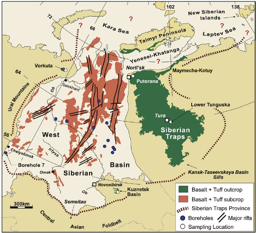
The extent of the Siberian traps. Source: Reichow et al. 2009, Earth and Planetary Science Letters, 277, 9-20
The Chelyabinsk meteor was by no means the first major event in the region. A very long time ago, the Earth here was burning. Lava came out of the ground and buried a quarter of Siberia under a kilometer of basalt. This was the famous Siberian traps – apart from the damage to Siberia, it wiped out almost all life on Earth. The entire train journey from Yekaterinburg (or Chelyabinsk) to Novosibirsk, with those millions of small birch trees (berezkas – the importance of this tree shows in the name: many languages use essentially the same word, showing that the name is older than any of those languages), had been on the buried platform of the Siberian traps. The taiga of birch trees and pines was growing on an unforgiving land.
In west Siberia the traps are buried under more recent sediments. Surface outcropping of the Siberian traps occur further east, indicated by green on the map below. They are centered on the area called ‘Tunguska’. This region is famous not for the Siberian traps – as it should be – but for a much more recent disaster. It is the location of another celestial visitor, one more damaging than the Chelyabinsk meteor. It became known as the Great Siberian Meteor of 1908; it is now more commonly known as the Tunguska event. Siberia does collect famous catastrophes.

Chelyabinsk
The meteor was about 20 meters across when it began to enter our atmosphere. It came in from the east-southeast, traveling at an angle of 18 degrees with the horizon. It first became visible at a height of 100 km, while moving at a speed of 15 km/s. The shockwave formed at 90 km. At 83 km height it began to lose fragments, and this worsened at 54 km. Peak brightness occurred at 30 km height; the meteor disintegrated at 27 km. Because of the small size of the meteor, the fragments escaped the shock front and were decelerated individually by the atmosphere. This may have helped to limit the damage from the explosion, and it also allowed some parts to reach the ground where they could later be recovered.
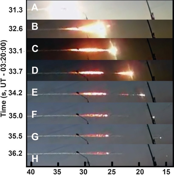
Footage of the Chelyabinsk meteor from a security camera. From A to H covers 5 seconds. A and B show the bright fireball at 30 km height when the object appeared as bright as the Sun. C and D show the secondary explosion at 27 km which is when the object largely disintegrated. Two remnants can be seen to survive in E and one in F and H. Source: Popova et al 2013, Science, 342, 1069-1073
The shock wave caused damage on the ground, mainly from broken glass. This damage occurred over an elongated area of 40 by 100 km, extended perpendicular to the line of travel of the meteor: this pattern is called a butterfly diagram and it helps to determine the direction of travel of the meteor.

Map of glass damage. The black line shows the trajectory of the fireball. Coloured circles represent town and villages with damage. Open circles reported no damage. Yellow points show where meteorite fragments were found. The contours show models for the pressure of the shockwave. White indicates the brightness of the fireball. Source: Popova et al 2013, Science, 342, 1069-1073
Directly underneath the fireball, the shockwave was strong enough to blow people of their feet and push in ceilings. UV radiation from the flash caused sunburn as far away as 30 km (perhaps made worse by reflection from the snow on the ground), but eye damage was avoided because people had time to look away. The heat was felt by everyone outside but it was not strong enough to ignite fires. The major cause of injuries was flying glass, made worse by the fact that the shock wave arrived as much as a minute after the flash, after the event seemed to be over and when people were not expecting it.
The energy of the explosion was around 590 kT. Most of the meteor disintegrated and evaporated in the destruction at 31-26 km, but small parts fell to the ground and one large fragment of some 500 kg fell into a lake. It has since been recovered.
The Chelyabinsk meteor was a long time in the making. It was a rocky object, which had split off from a much larger object (probably after a collision) about 150 million years after the solar system formed. About 1 million years ago it had a close encounter (probably with Earth) which made it break up further. The fragment that was to hit Siberia in 2013 was now on an orbit that took it from outside the orbit of Mars to the orbit of Venus. It hit Earth on its outward journey, coming in from the inner solar system. No one had seen it coming because it came almost from the direction of the Sun and therefore was hard to detect.
Other fragments of its parent body may still be in orbit around the Sun.
Tunguska

An Evenk family of around the time of Tunguska. Source: https://www.museum.state.il.us/exhibits/changing/journey/hunters-people.html
It happened on Tuesday, 17 June, 1908, at a quarter past seven in the morning. (If the date comes as a surprise to you, Russia still used the Julian calendar. On the more modern Gregorian calendar, the date was 30 June – Russia was living in the past.) This was the time of Tsar Nikolai II. Much of the Great Siberian Railroad had already been built, and it had opened up the region around the track. But away from the railroad, travel was very difficult. Rivers formed the main transport routes. In this region that was mainly the Yenisei and its tributaries. One of those was a river called the Podkamennaya Tunguska. Small settlements had formed along the rivers, with factories, farmers and fur traders. But otherwise the area was inhabited mainly by nomadic reindeer herders from the Evenk people (at the time called Tungus by the Russians), who did not have a written language at the time. They were not treated well, as described in a classic Russia novel ‘The gloomy river‘, telling a story from the Siberian gold rush. The area is cold, with average temperatures ranging from -25C in January to +15C in July. There is permafrost and this keeps the area swampy in summer in spite of the limited precipitation. The local taiga consists largely of pine trees, birch, spruce, willow, and larch, with a ground cover of blueberries, cranberries, mosses and lichens and with a generous helping of mosquitos.

Lower Tunguska river, running to the north of the Podkamennaya Tunguska river. The meteor hit the region between these two rivers. Source: V. Kiselev, 1989, Sovetskaia Kul’tura, 12
The explosion did tremendous damage and caused three deaths, perhaps more. But this news took a very long time to come out. A newspaper in Krasnoyarsk mentioned the event a few weeks after the event, when some news began to trickle out. They reported that in Kezhemskoye (about 150 km from the blast but the epicentre was nt known at the time) “In the morning there was a noise as if from a strong wind. Immediately behind this came a terrible blow, accompanied by an earthquake, from which the buildings were literally shaken, and it was as if a strong blow had been made on the building by some huge log or heavy stone. The first blow was followed by the second, the same strength and third. Then – the interval of time between the first and third blows was accompanied by an unusual underground buzz, similar to the sound from the rails, over which a dozen trains allegedly passed at a time. And then within 5–6 min there was exactly the same artillery shooting: followed by about 50–60 strokes at short and almost the same intervals. Gradually, the blows became weaker towards the end. After a 1.5–2 min break after the end of the continuous “firing”, six more blows, like remote cannon shots, were heard, but still clearly audible and sensed by the earth shaking”
Semyinov was a farmer, living near Vanovara, some 50 km south of the epicentre. his story was reported only after 1920:
“About eight o’clock in the morning, I had been sitting on the porch with my face to the north, and at this moment in the northwest direction appeared a kind of fire which produced such a heat that I could not stand it. And this overheated miracle I guess had a size of at least a mile. But the fire did not last long, I had only time to lift up my eyes and it disappeared. Then it became dark, and then followed an explosion which threw me down from the porch about six feet or more but I heard a sound as if all houses would tremble and move away. Many windows were broken, a large strip of ground was torn away, and at the warehouse the iron bolt was broken. ” Semyinov was found unconscious by his daughter.
Leonid Kulik in 1924 reported a story from closer to the centre of the event. It was told by Lyuchetkan:
The spot where all the trees are now dead had previously been used by a rich relative as a pasture for a large herd of tame deer. After the fire they went to find the herd and found many scorched carcasses, but never found a large part of the herd, dead or alive. Also some small storehouses in which the man used to keep implements, and so on, were all completely ruined; everything in them being either burned or melted, clothing, utensils, deer equipment, dishes and samovars, so that only a few buckets remained fit for use out of all his property.
The ‘deer’ were reindeer. Each family group of the Evenks would have some. In the summer, these were grazed in larger groups, in this case using this particular person’s pasture. This herd might have been 20 or 30 strong.
(The main source used for these quotations is Jenniskens et al. 2019, Icarus, 327, 4-18)
The shockwave covered a long distance. Even 400 km away, fences were blown over by three or four thunderclaps, and at Kansk, 600 km away (on the new Siberian railroad), a train driver stopped his train because of the violent vibration of the air and the loud noise, and when he reached the sidings, asked for the train to be checked to see whether some of the goods might have exploded. Seismographs worldwide recorded the seismic waves (caused by the shockwave hitting the ground), while barometers detected the air pressure wave. In Potzdam (Germany), the air wave was seen twice, having circled the globe. And in Europe, there was ‘night dawn’ for several days when the moonless skies were brightened by clouds of dust and ice at 80 km height.
Many of the reports were obtained only decades later while scientists were looking for the epicentre. Details may be confused: memory is not reliable over such periods of time. But there are consistent reports of extreme brightness seen even from the inside of thick tents, and of heat and fire. Very notably, there are no eyewitness reports available from near the centre of the region.
The damage near the epicentre was substantial. However, there wasn’t much property to be damaged. Tents were blown over, and reindeer were lost – dead or maybe just fled. Most of the damage was among the trees: over a large area they were just blown over. Whole forests were felled. The map below shows the butterfly pattern of the fallen trees, with the arrows showing the directions of the falls. This area is similar in size to that of the Chelyabinsk glass damage. At a distance where the latter managed to break glass, the former toppled trees! The whiter area inside the red contour is where the trees not just fell, but also were burned.
Surface burns of the trees were reported by Kulik out to the edges of the tree fall area. However, the forest had suffered a fire some decades before 1908 and those burns may have predated the Tunguska event. But the reports consistently mention the heat from the explosion, and the fire damage in the central region is from the meteor. Also be aware that in a mature, undisturbed temperate forest, as many as 30% of the trees may be dead while still standing. Some of the trees that were flattened in the Tunguska event may not have been particularly strong.
But the 1908 fire was extensive. A report from 1961 states “…distinct signs of the spreading of the 1908 treetop fire were found in the form of arcuate strips and surviving older forest to the north of the Kimchu River, at a distance of 1 to 2 km from the bank, in the stretch from Lake Cheko to the extensive marshes on the left side of the river. In this area the fire spread from south to north. Indications of the fire’s spread were found on heights to the north of Lake Cheko, as well as on the western slopes of hills 373.6, 491.0 and 476.0. From here the boundary of the fire area can be traced easily along an arc from the mouth of the Chavidokon River to Mount Shakharma. The surviving traces of the fire-line advance indicate that it spread toward the west and southwest, i.e., as if from a central depression. The treetop fire here gradually changed into a ground fire, with some damage to the old forest. On the northeastern slopes of the heights where the headwaters of the Churgim River rise there are arcuate strips of old forest, convex toward the south. We find identical signs of the spreading fire on Mount Shakharma, but facing east… The old forest remained intact only in narrow strips along the banks of rivers with highly developed valleys and in the form of solitary trees in the midst of swamps and rock streams.” (http://www.defendgaia.org/bobk/tungmet.html)

Map of the tree fall and tree burn area
The yellow dots on the tree fall map show the locations of known eyewitness reports. They are near the edge of the tree fall area, but not further in. Perhaps that is because people there did not survive. There are a few casualties reported in the oral stories, but perhaps there is a message in the gap of records.
History
But why did it take such a long time for the reports to surface, with all the risk that memories had become distorted or were reported only second-hand? In 1908, few people seemed to have realized that something significant had happened. There were a few notes in the Russian Bulletin of the Central Seismic Commission, which probably was not widely read:
June 30, Town of Kansk. The first shock caused the doors, window and votive lamp to shake. Subterranean rumblings were heard. About 5 to 7 minutes later there was a second shock accompanying the rumbling. A minute later there was a further shock less severe than the preceding two. It is stated that the earthquake was accompanied by the fall of a meteorite near the village of Dalaia. Peasants relate that 70 km north of Kansk in the Ustianovski district there was also an earthquake accompanied by subterranean rumblings.
June 30. Kuriski-Popauich Village; District of Kansk.-At 0 h. 37 m. a severe earthquake was observed in the vicinity of the village. After this there were two loud bursts, like the firing of a large calibre gun near Lovat Village. It was afterwards found that a large meteorite had fallen.
(The times in these reports are given in GMT). The earthquake was also registered at Tiblisi, Tashkent and Irkutsk but the relation to the meteor was not generally recognized at the time. Only the director of the Irkutsk Observatory made this connection. He determined that the stone had fallen near the Podkamennaya Tunguska river, 600 km from Kansk. No one went to have a look: the area was too inaccessible.
Leonid Kulik became interested in 1920, and he found the funding to go to Kansk and collect more information about the event. Among his findings is the following report, which reached him in 1924:
A certain N. N. Kartasheff states: ” According to Ilia Potapovich, a Tungus living on the Teter River, his brother (now an old Tungus, speaking scarcely any Russian, who was seen by Kartasheff) was living 15 years ago on the Chambe River when a terrible explosion occurred. The force of the explosion was such that for many versts along the Chambe River trees were uprooted on both sides of the river. His brother’s tent was hurled down, the wind carried away the top, deafened his brother, dispersed his reindeer, which, when he recovered his senses again, he could not collect, except a very few of them. This all affected him so much that he was ill for a long time. In the part of the forest which was uprooted a big hole appeared in one place from which a stream flowed into the Chambe River. The Tungus road formerly passed through this place; it is now abandoned because it is blocked and impassable and further because the Tunguses are terrified of the locality. There are Tunguses on the Chambe River now who could lead one to the spot. N. N. Kartasheff is of the opinion that Ilia Potapovich’s story is not true.
Kulik began to explore, and managed to finally reach the location in June 1927, after 3 months of travel from Vanovara. He found the devastation exactly as described. A summary of his ordeals was published in The Geographical Journal of March 1929:
“At Taishet the railway was exchanged for sledges and the journey was continued amid snowstorms and at a temperature of -40C through the boundless coniferous forests. From Keshma on the Angara a reindeer track through the Taiga was followed and as the party approached the region of the Stony Tunguska [Podkamennaya Tunguska], they were struck with the frequency of burned patches in the forest. Reaching the factory of Vanovara on the Tunguska about the end of March, Kulik obtained the services of a Tungus family with their reindeer, but the deep snow made progress slow and even the reindeer path at last came to an end. By pressing on on snow-shoes Kulik reached a commanding spot whence a view to the north showed a vast snowy expanse, bare of forest, which he took to be the locality he was in search of. A further advance being impossible, he returned to Vanovara determined to make a new attempt by water, as the rapidly melting snow made land-travel impossible. Rafts were built, and the ice-obstructed streams were navigated with the greatest difficulty, the men having frequently to carry the baggage on their backs through the rapids. Pushing desperately on, Kulik took notice of the varying directions in which the trees had been prostrated, and at last convinced himself that he had actually crossed the spot on which the meteorite had fallen. The heated gases and solid particles must have spread out in all directions from the point of the impact, carrying devastation around, and either overthrowing the trees of tearing or burning off all their branches. About ten shallow craters were found, with diameters of 10-50 metres and an average depth of 4 meters, their bottoms being covered with bog-moss. The traveler was almost at the end of his resources and was quite unable to excavate the ground in search of fragments of the meteorite. He reckons the area affected by the tornado at hundreds of square kilometers.

Kulik’s house in Tunguska. https://www-th.bo.infn.it/tunguska/tu99foto.htm
Kulik’s reports drew widespread attention. C. Cave in 1930 heard about the report and linked it to the peculiar, unexplained air waves which had been seen in the UK in 1908. F. Whipple picked up the story: he publicised the evidence for ‘the great Siberian meteor’ to the English-speaking world. From here on the Tunguska event became known to the world.
Track
The oral reports left the actual trajectory of the fireball unclear. This was for two reasons. The meteor had moved very quickly across the sky, in just a few seconds, so few people would have caught the movement itself. By the time they looked up, only the trail was visible (as in the Chelyabinsk videos) but not in which direction along the trail the meteor had moved. The second reason is the wide region over which the meteor was seen. As many had seen the event from a considerable distance south, the oldest publications said that it had come from the south. The butterfly pattern shows this is not correct: the travel was closer to east-west.
Arguments have been made for the bolide coming in from either the west or from the east but the old oral reports do favour a direction coming in from the east. The angle of entry is best determined from where the meteor was visible and where it was behind mountains on the horizon. The combination of all show that the meteor came in from just south of east, and travelled at an angle to the horizon of about 25 degrees. This trajectory is in fact very similar to that of the Chelyabinsk meteor.
The orbit of the original body was not identical to Chelyabinsk: the orbit was slightly more elliptical, moving between the asteroid belt and a bit outside of the orbit of Mercury. Like Chelyabinsk, it came in from the general direction of the Sun: the Earth was hit while the object was returning from a sojourn in the inner solar system.
Explosion
The meteor entered the atmosphere with a speed of 15 to 20 km/s or more, moving fast across the sky in only a few seconds. The first visibility was at 110 km height. What happened after that is not nearly as well known as for Chelyabinsk. Reports of two objects and trails suggested it may have fallen apart part way through its descent, however this may also just refer to the debris cloud after the explosion, which can bifurcate because of buoyancy of the hot gas in the trail. Some of the descriptions mention that the fireball was red. That would have been the debris cloud, after the explosion while it was cooling.
The very strong explosion shows the full destruction at the end of the trajectory. Chelyabinsk which had an initial explosion at 30 km and the final, much larger one at 27 km. But the Tunguska meteor reached much lower altitudes. Its big explosion occurred between 6 and 12 km height.
Models indicate that as an object the size of Tunguska travels hypersonically through the atmosphere, it becomes enveloped by a shock wave which shields it from the air. Fragments that come off remain within this envelope. That is unlike Chelyabinsk where those fragments were slowed down by the air and came down by themselves.
In these models, the object begins to deform at 20 km altitude, when the sreess exceeds the strength of the material. It now behaves more like a liquid under the pressure and takes on a pancake shape. That increases the drag with the atmosphere and generates a lot of heat. The objects completely disrupts and evaporates. This happens so fast that the vapour cloud has no time to expand, and the pressure an temperature in the vapour becomes enormous. This causes the radiation flash. Th extreme pressure pushes the cloud out in all directions – some backward along the atmospheric hole that the meteor just drilled, some up and some down. This adds to the shockwave (sonic boom) which comes especially from the final part of the trajectory, through the densest air. (Note that at larger distances there may be two sonic booms for each shockwave, one at the rise of the pressure and one at the subsequent fall.) At larger distances, the impact was mainly from the sonic booms (shockwave), but close to the epicentre the downward vapour cloud may have caused winds and perhaps heat.
The burning of the trees (and reportedly of some of the reindeer) shows that the energy was a lot higher than Chelyabinsk: the explosion is estimated at 10-15 MT, which is 20 to 30 times larger. (Some estimates of the energy are much lower or much larger but these values represent the most likely range.) This generated much more radiation than at Chelyabinsk: the heat was felt as far as 70 km away, and ignited fires over a large area.
People below the explosion would have suffered from more than just a touch of sunburn. If outside, first-degree flash burn and blinding eye damage was likely. (However, many reports came from Evensk people who had been inside their tents (called ‘chums’).) The shock wave would have caused eardrum rupture, something that did not happen at Chelyabinsk. People can lose consciousness from such a shock and in fact this was reported for several people even at the edge of the tree fall region. At the centre, the shock wave may even have been lethal. The area of tree fall begins about 4 km from the epicentre: at the centre itself, trees were left standing although singed and stripped of their branches. (It is sometimes called the ‘telegraph pole region’, as that is what the trees looked like.) This pattern indicates that the explosion happened at some 8 km height, so that the shock wave came in vertically at the centre leaving the trees damaged but standing. Further out, the shock came in more horizontally and the trees just snapped.

Picture: Leonid Kulik, May 1929. https://www-th.bo.infn.it/tunguska/tu99foto.htm
The epicentre of the singed trees is 2-4 km east from the centre of the tree fall: the heat originated a second before the vapour cloud exploded, and the object moved a few kilometers in between.
The total area where the trees were flattened is about 2100 square kilometers. Some 80 million trees were flattened! But this was only discovered in 1927. The area was so remote that although an expedition had been sent out in 1921, they had not found the epicentre itself.
The epicentre is in a crater-like valley, which may be one of the central craters of the Siberian traps. Clearly this is a spot that attracts double trouble and it is one to avoid! The 1927 expedition of Kulik described it as:
The outer fringe of the “windfall” bears traces of a continuous burn from above. Moreover, the branches of fall trees, as well as those which still remain standing, are, as a rule, broken and destroyed. Every surface of a break bears a little bit of charcoal. There is no break without a burn. The central area of the “windfall” lies on permanently frozen, hilly peat mosses which alternate with swamps among the hills. This central area is surrounded by burned trees, still standing but totally devoid of branches. (Kulik 1938: https://adsabs.harvard.edu/pdf/1938ASPL….3…78K).
This description indicates that the central area had not been particularly hospitable before the event, and perhaps was not or very little occupied. This may have limited fatalities to the three we know about. However, the lack of reports from within the tree fall area is very notable. There were no survivors in this region, but whether this is because everyone died or because no one had been there is not known. There is one early report which states that several families on the Taimur river perished, but we don’t know which river this was. (A Siberian taimen is a 2-meter long(!) type of salmon which was widely distributed along the main rivers of Siberia.)
Why the evidence for burning on the breaks in the trees and branches? This was not due to the flash, as the shockwave arrived some time (15-30 seconds) after the flash. It indicate that material had caught fire. This is most likely the dry moss (this being summer) on the trees. The trees themselves did not catch fire. At the outer edges of the tree fall region, some of the charring may have occured decades earlier, during a forest fire.
On the night after the explosion, high altitude clouds brightened the night skies in Scandinavia and Scotland. The clouds were white to golden and so bright that it was possible to read by the light, even though there was no moon. (It was two days after new moon.) In Gothenburg, the light appeared an hour after sunset and lasted until 2 or 3am. In Stockholm, the luminous clouds covered only part of the sky. Aberdeen too saw the white night light. Greenwich reported a bright sky in the north. The luminous clouds were seen over three nights. But elsewhere in Europe and in the US, these clouds were much less bright or not seen.
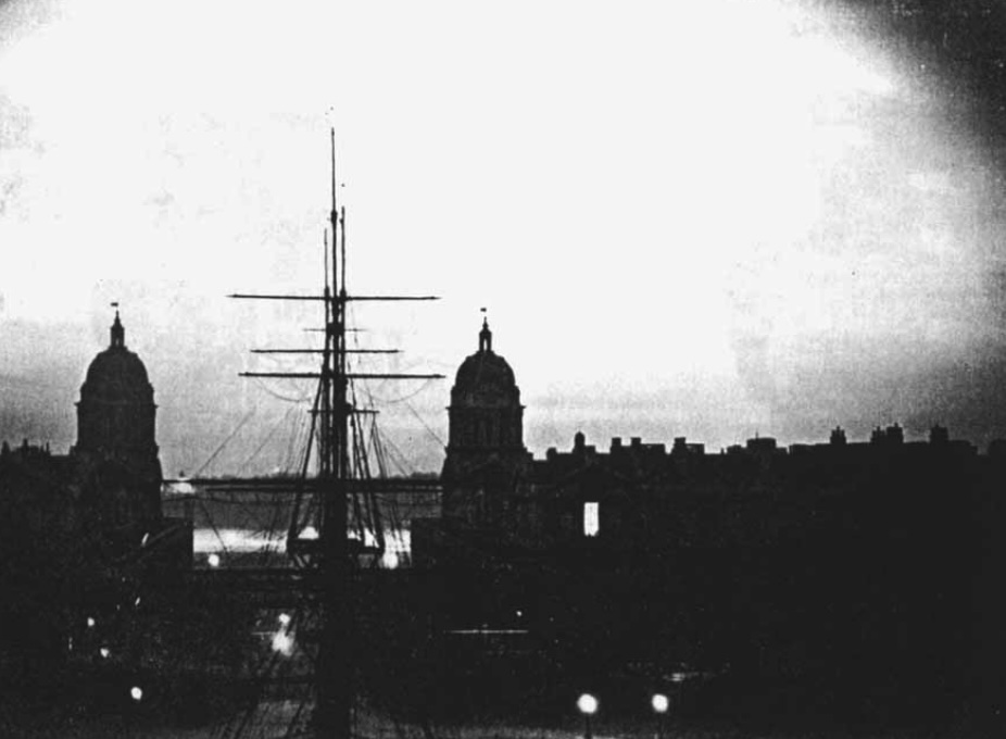
A photograph taken on the night of 30 June at Greenwich Observatory,. The ship is the ‘Fame’, used for training purposes (and located on land)
The explosion caused an atmospheric pressure wave which was detected in various places in Europe. Below is a trace from Petersfield in the UK. It shows two distinct waves, an early one with a slow fluctuation and one arriving 15 minutes later which fluctuates much faster. The first travelled at a speed of 323 m/s, the speed of source in the troposphere. The second one travelled at 308 m/s, and apparently traveled through the stratosphere.

The air wave seen in Petersfield. Although this disturbance was noted by N. Shaw in 1908, the cause was not realized until 1930! Source: F. Whipple, 1930>
Debris
Kulik reported that there were some ten small cone-like craters, 10-50 meters across and 4 meters deep, in the cemtral area. He thought that each was caused by a fragment of the meteorite. But no debris was found, in spite of several searches. This is in contrast to Chelyabinsk where many fragments and one large piece were recovered and in some cases being offered for sale.
A 2-meter boulder was found in the permafrost close to the site of the eruption. This ten-ton quartzite boulder became known as ‘John’s Stone’ and was proposed to be a remnant of the explosion. However, quartzite is not found in meteorites, and the alternative suggestion that it came from Mars was not too plausible, to put it midly. (Tsunguska has a tendency to attract the wildest speculations, from people with a healthy imagination but a more limited grasp of reality.) Instead, the rock seems to be related to the Siberian traps, where silicate dissolved in hot water and became deposited on this rock.
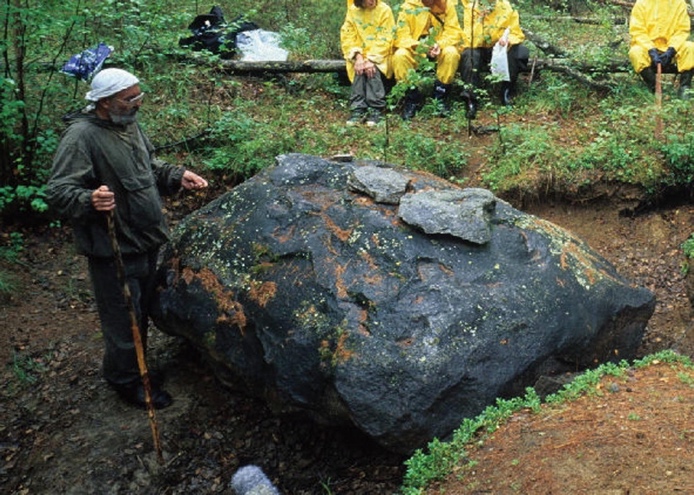
This is not it. A stone found near the explosion site, but not related to it
Cheko Lake and Suzdalevo Lake
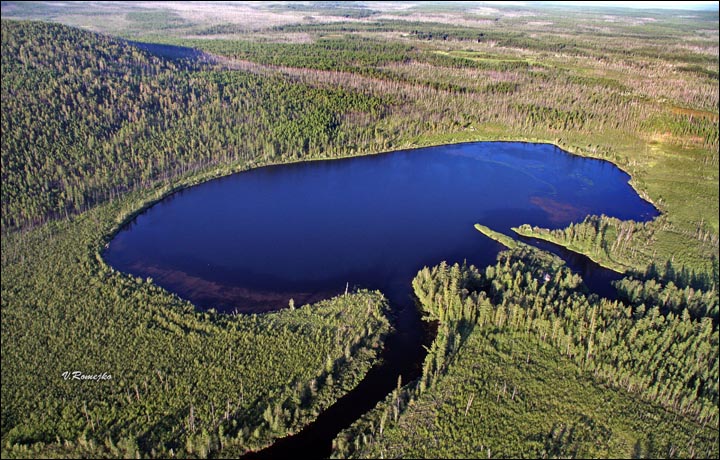
There is no obvious impact crater associated with the explosion. The area is swampy and a crater would likely show up as a lake. There are few such lakes here. Lake Suzdalevo is interesting. It is about 20 km southwest of the explosion site. In local reports, the lake is said to have appeared just after the explosion and that it did not exist before. Was it formed by a fragment from the impactor?
Apparently not. The shallow lake next to the Chamba river (the main access route to the region) is 150 meters wide but only a few meters deep. An impact structure that size would be far deeper. The sediment in the lake is older than 1908. The lake is an old river arm, not a bolide. The lake is named after someone called K. Suzdavelo, a merchant from Vanovara who visited it sometime after 1908. The story that it didn’t exist before that time may just refer to the fact that it was visited ony afterwards. The non-existence of undiscovered terrain is a common misconception.
Lake Suzdalevo. Source: https://www.natur.cuni.cz/fakulta/aktuality/archiv-2022/ovlivnila-tunguska-udalost-vodni-ekosystemy
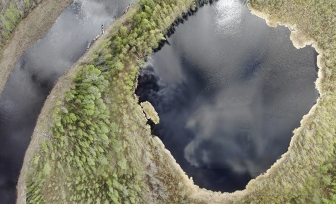
About 8 km NNW from the explosion epicentre lies Lake Cheko, 350 meters diameter. It drew attention for its shape (elongated along the trajectory of Tunguska) and its large depth of 53 meters, far more than expected in the region. It lies in the path of the Kimchu river which flows in and out of the hole. Again there were reports that the lake was recent and had not existed before 1908.
Lake Cheko
But studies of the sediment in the lake refute this. They find an age of 300 years or more. Furthermore, several lakes were found in the region which are far from the epicentre but with a similar shape and depth. The origin of Lake Cheko is still unknown, but it does not appear to be related to the Tunguska event.
Neither of these lakes has a raised rim, which is generally seen in craters. However, craters in such swampy conditions behave differently. The meteoric fragments bury themselves far deeper than in craters in solid rock. The explosion energy than becomes deposited at this depth. It excavates a cavity. The upper layers now collapse into this hole. Such a ‘collapse crater’ (which can also occur in volcanoes) do not have raised rims and have funnel shapes. Although neither of the two lakes appear to be young enough for this, the ten funnel-like holes found by Kulik in 1927 do fit the description, although with much smaller fragments. But this also failed: Kulik later found more of these holes, and excavated one. At the bottom, a decaying tree stump was found. The trees may have died in the Tunguska event: they were perhaps toppled, with the size and depth of the depression coming from the root ball. But the trees did not fall from the sky and were not extraterrestrial.
Several searches for large pieces of debris have not found anything. Instead, microparticles were found in the 1908 peat layers: metallic spherules, less than a millimeter across. Peat cores clearly show the Tunguska 1908 catastrophe layers, and these have a higher concentration of the spherules. Could these be debris from the explosion, droplets melted in the explosion? Detailed analysis showed that 90% of these spherules consisted of iron-oxide and contained no or little iridium, quite different from what is known from meteorites. The composition is in fact consistent with an industrial origin, although this has also been disputed. A second group seem to come from the continuous flux of micrometeorites which falls on Earth. That leaves a few grains which appear to be extraterrestrial but without a clear origin. These could be from Tunguska, but without dates this is hard to prove. Carbon spherules were also found in the peat but these could have formed from the shockwave impacting the peat. Tunguska destroyed many trees and stripped the bark from them, and stirred up the vegetation and the soil on the ground. Not all pollution may have come from above: there was redistribution of pre-existing pollution.
Asteroid or comet?
Without certified debris, it is difficult to know exactly what the object was. The energy of the explosion indicates that it was roughly 60 meters across, if it was a stony asteroid. An iron asteroid is unlikely, as with higher density it would have been more likely to reach the ground and leave remnants, or a crater. Such objects are also less common than stony or icy objects.
The lack of debris led to the suggestion that the object was a comet, a snowball from space which completely evaporated in the explosion leaving nothing but water This possibility remains popular. A comet would need to be somewhat larger to provide the same amount of energy: it is estimated as a bit less than 100 meters. The orbit fits with a group of short-period comets, caught by Jupiter with similar orbits. A long-period comet, such as Halley, can be ruled out though as they have very different orbits. The main argument against it that such a weak body should have self-destructed much earlier in the trajectory through the atmosphere. However the concept of comets as snowballs is dated. We now know they contain much more than water and can have a high fraction of carbonaceous material. Short-period comets also lose much of their water during the frequent approaches to the Sun.
The possibility of a stony asteroid is far from dead. The orbit is similar to Chelyabinsk and this would fit with an origin in the asteroid belt.
Models for the entry into the atmosphere find that objects of 100 meters diameters will often reach the ground (depending on incoming velocity, entry angle and strength of the object) but for 50 meters across most will not unless they enter near vertically. The object is enveloped in a protecting shockwave and can vaporize completely in the explosion. This is true for both asteroids and comets: both types can fit the event, the energy, the explosion altitude, the lack of craters, and the damage on the ground. Large airbursts can be very damaging regardless what causes them!
What happened after the explosion? The body of the meteor evaporated leaving little solid material behind. Some of the remains will have drifted down: one model predicts that the main debris may have landed some 11 km to the west-northwest. Some may have been lifted into the stratosphere by the heat of the explosion. Ice depositing on the dust grains could form the luminous clouds that caused the bright nights in northern Europe. Two US observatories found that the atmosphere was less transparent for several months after the event. This may be due to the same dust. We don’t know whether this was dust form the final explosion, lifted up even above the stratosphere, or dust lost by the meteorite during its earliest decent through the atmosphere. It has even been suggested it was dust in a cometary tail (which assumes the object was a comet) which arrived separate from the main body, but this is unlikely: the amount of material in a comet tail is very small, and the bright nights would have been seen over a much wider area than they were.
It would really help if we could find some debris, to find out what hit us. The models are not conclusive without these data. And it would also help us to determine how common Tunguska-type events are. Airbursts are not uncommon: they occur about ten times per year, of which on average 2 have an energy above 1 kT. These airbursts are much smaller than Tunguska, and come from objects 1 -2 meters across. The Kamchatka meteor of 2018 was likely about 10 meters across and was the largest known since Chelyabinsk. Chelyabinsk-size events may happen once in one or a few decades. Estimates for Tunguska-type events range from one in 300 years to one in 2000 years. Most will occur over the sea and do little damage. The risk of one hitting a populated region is not high – but it is not zero either.
Albert, January 2024

Oops – said the dinosaur


Quakes are picking up again.
Kilauea earthquakes are spreading beyond the connector towards the NE near Keanakakoi Crater, and towards the SW towards Puu Koae, making a line that is parallel to fissures in the area. We have a dike!
SDH inflation surprisingly now seems to be coming from the north, I wonder if this intrusion can manage to erupt from the south wall of the 2018 caldera.
Seems the UWE tilt is slowing down, although it might either drop again or reinflate.
The difficulty of the depth of the current magma means that a vertical move will likely also include a horizontal move. So the location of the possible future eruption can be on a different place than the current earthquake swarms. Can we estimate the horizontal direction of rising magma?
Seems over. The summit is reinflating.
Well, there’s still a bit of quaking, but very subdued.compared to earlier.
Yeah, I don’t think it’s *quite* through yet. Definitely subsiding overall, but still lots of quakes with some occasional resurgent swarms.
“Seems over”.
Or maybe not, Halema’uma’u deflating again (UWE, IKI tiltmeters), and SWRZ connector quakes are up again. Kilauea seems fixated on the SWRZ connector.
Yep, even just in the past 30-60 minutes, there has been a significant increase in quake frequency.
Not alot of tremor though.
Deflating Halema’uma’u can still mean a SW Summit eruption.
Yes magma pulses down the SWRZ connector a new behaviour since summit eruptions began in 2020, feels like it will be an outside caldera eruption pretty soon ( althrough not necessary next time it erupts ) sadely they will proably restrict acess to an eruption for tourists, but coud be very intense too and fast as eruptions are in the area, 1974 and 1971 made some spectacular lava falls, hopes to see that again..if it can flow over the caldera edge
Would be a good thing to restrict access to this one, being downhill of a curtain of fire eruption is about as safe as being downhill of a dam bursting. 1974 lava flowed about as fast as walking speed but that is walking speed on a flat solid surface not loose gravel…
Actually now that I look at it, the September eruption was not all that different to the 1970s eruptions, 18.5 million m3 of lava most of which erupted on the first day.
Loves how fluid the Kilauea summit lavas are, they are looking like floods of liquid aluminium 🙂 yes very crystal poor and quite unevolved, its rare for any central well developed volcanoes to have lava like this, most does not have a magma supply thats fast enough, Kilaueas hyperfast supply makes it able to produce souch nice crystal poor thoelite, minus some cooling and minior evolment on the way up its pretty much a pure astenosphere melt.
I think the SDH seismometer stopped updating.
Will have to look at it properly later but the dike seems to have started at the top of the SWRZ connector and goes some way down the SWRZ but also up to the caldera ring fault where the quakes are currently concentrated. The southernmost part of the dike is still under land that is 1000 meters elevation while the floor of Halemaumau is about 60 meters lower. So if there is an eruption it will probably be in the southwest part of the caldera.
The intrusion is relatively large and draws from a large supply, if an eruption does start then it could be different to those which we have seen recently. Something more like 1959 with huge fountains as the whole dike starts to degas through the vent. Even if not, there is a weak point now so something has to give soon.
The swarm has really picked up again.
New info from USGS:
Activity Summary: Kīlauea volcano is not erupting. An increase in seismicity in the south caldera region started this morning and has remained at high levels since 3 a.m. HST. Kīlauea’s summit remains pressurized; in recent months unrest has escalated quickly, and an eruption could occur in the future with little warning.
Summit Observations: Seismicity began to increase just before midnight. Since 3 a.m. HST, 25-30 locatable earthquakes have occurred per hour at depths of 1.5–3 km (1–2 mi) below the surface. Earthquake clusters have migrated between the area just south of Halema’uma’u and the region southwest of the outer caldera boundary. The most intense activity occurred between 6 and 8 a.m., when earthquakes were clustering just south of Halemaʻumaʻu. There have been over 180 locatable earthquakes in this region in the past 6 hours, with magnitudes ranging from a maximum of 3.4 to less than 1. Several of these earthquakes were large enough to be felt by HVO staff in the field, who also reported rockfalls on the south side of Halemaʻumaʻu.
At the time of this report, earthquake activity remains elevated, and the overall number and intensity of earthquakes is fluctuating with time. Periods of increased seismicity can be expected to continue during repressurization of the summit magma reservoir, which has been ongoing since the end of the September 2023 eruption.
Kīlauea’s summit region remains at a high level of inflation. Nearly 10 microradians of change have been recorded since 4:00 a.m. HST at tiltmeters near Sand Hill and Uēkahuna bluff. Both of these tiltmeters have shown highly variable directions and rates of tilt, typical of shallow crack growth that can precede either an eruption or shallow intrusion. Step-wise changes in the tilt signal are likely due to the instrument being shaken by nearby earthquakes or rockfalls.
Sulfur dioxide (SO2) gas emission rates remain low. Field measurements indicated an SO2 emission rate of approximately 70 tonnes per day on January 17, which was similar to measurements in October, November, and early December.
Patterns of ground deformation and earthquakes since this morning indicate that pulses of magma continue to move beneath the surface of the region south-southwest of Kīlauea’s summit. HVO is closely monitoring Kīlauea volcano, watching for any signs of accelerated rates of earthquakes or ground deformation, or signs of shallowing earthquake locations, which usually precede a new outbreak of lava or propagating dike. We are also closely monitoring gas emissions and webcam imagery.
On that same note, looks like the seismographs have not been updated since about 10:00 am HST.
Seems that HVO dont see the quake swarm as a dike but rather as tbe same activity as seen before only a lot stronger. Not sure about that but then they do have access to all the instruments not just a few.
Still if this is a dike the quakes are mostly at depths of around 1 km, which presumably is 1 km below sea level so 2 km below ground in that location. But still that is the base of the dike, the top is much shallower. There are a few quakes within the northern end of the swarm that are under 1 km deep. I dont think this particular dike will erupt but now a weak spot exists it is likely to be reused, just like at Svartsengi.
Have they issued a warning? If the threat increases, shouldn’t they communicate better about the risks in SWRZ area? Emergency management is the main task of volcanic observatories. Until now I haven’t read any advice from HVO about what to do and not to do.
The Ka’u Desert cam, MITDcam, is out of order. Probably a coincidink, but you never know…
Ok it is certain there is an intrusion going on now, the 1 week tilt at UWEV has plummeted, the 2 day tilt and it seems most other sources havent updated yet.
Still, the amount it has acrually dropped is not even to the bottom of where it was 1 month ago, which will likely change but goes to show how much magma was able to move without breaking anything.
It also means either this dike is going to erupt or another one will form somewhere else and do it instead. This dike also has a trajectory that it could potentially erupt both within the caldera and down on the rift, if it manages to intersect the lava lake and also open a vent lower down then things could move quickly…
In case you were unaware, on the Two Pineapples livestream, there are actively updating spectrograms: https://www.youtube.com/watch?v=v4K5Tr0o5dM
The quakes have come in surges. For a while there this morning (Hawaii time) it looked like everything was subsiding, but then it picked back up again in the afternoon and is currently still going fairly strong (though not quite as intense as at its peak).
Looking at the quakes I dont know if we should expect the dike to erupt in the immediate future. Up until a few hours ago it was getting shallower to the north but seems to have hit the caldera ring fault and stopped. Now it is going south but it is also getting deeper as well as having shallow quakes, so the dike is expanding both up and down relative to the source area. Which is something that I think also happened in 1975 and 1981. 1975 erupted immediately just before the new year then began rifting for over a week, and 1981 didnt erupt at all, so we probably missed the most likely time for an eruption to happen.
Thing is though, 1975 and 1981 were major rifting events that were abruptly cut off by major changes elsewhere in the volcano. 1975 was within a year of the 1975 Kalapana earthquake that opened up the ERZ. 1981 I think was probably a somewhat delayed and ‘failed’ attempt at a second round of rifting in the 1975 location, held back by most of the magma going elsewhere (although the intrusion was very large, calling it a fail doesnt feel quite right). Then of course Pu’u O’o started about 1.5 years later.
Now though the ERZ is seemingly cut off, and there was another massive quake only 6 years ago, so I dont think it is likely we will see the south flank slide again like that. The ongoing intrusion therefor only has to compete with Halemaumau which loses its advantage over the supply with every eruption thaf raises the crater floor. The magma supply rate now also seems to be higher than in 1975, probably even higher than during the Pu’u O’o era, so if this rift can get lower than the elevation of the crater floor in Halemaumau I think an eruption will occur in the Kau desert this year. But maybe not this week, unfortunately.
700 quakes today, double the amount of any day on Kilauea since 2018
The red (recent) earthquakes are moving SW now. This could mean that magma searches for the easier paths on lower altitudes of SWRZ. Maybe the aim are the Kamakai’a hills?
And -25 microradians deflation
The area of Kamakai’a Hills can host older evolved reservoirs. Are there more like this? A possible intrusion of new hot basaltic magma into an old evolved basaltic-andesitic one can cause a Strombolian eruption. Sometimes eruptions (f.e. Lailan Estates 2018 or Hekla) first have explosive viscous magma before the more hot and liquid magma follows.
https://www.usgs.gov/news/volcano-watch-kamakaia-hills-what-are-they-and-why-are-they-there
That assumes the evolved magma is shallow enough to interact with the new dike, it might be deeper down, 5 km or so. I dont know if any actual study on this has been done though, or if it is possible to find it from composition.
I guess if the two do interact a strombolian eruption or maybe a tall fountain could result. But I dont think the Kamakaia eruptions in the past were caused by dikes in the current area, being more local in origin from the end of the connector.
The Strombolian cones of the Kamakai’a hills remind to small versions of Mexico’s Paricitun, maybe the eruption style is similar. I’d imagine f.e. an ongoing strombolian eruption for some days or weeks.
Thats why I think the Kamakaia eruptions in the 1800s were not triggered by the sort of intrusion happening now. If the current dike intersects evolved magma and erupts it would be a different sort of eruption. Maybe like fissure 17 with a sort of continuous strombolian fountain and a thick a’a flow. That seems to be how the Kamakaia eruptions did start but they lasted a long time while intrusions that have happened from the upper connectors have historically been very fast to form and will fail quickly if they dont form a stable vent, hence all the short eruptions and intrusions.
Map an depth of current earthquakes show an accumulation of earthquakes just west of 155.3°. At the same time the deep earthquake swarm of Pahala continues (big blue balloons at 30km depth).
https://www.flickr.com/photos/194933949@N05/53502169981/in/dateposted-public/lightbox/
Four shallow earthquakes in the past 2 hours, something happening?
(This is from 12:27 UTC).
https://www.flickr.com/photos/194933949@N05/53502179776/in/dateposted-public/lightbox/
And earthquakes in past 2 days and I am noticing a swarm of shallower earthquakes. (Taken at 12:36 UTC).
)Apologies for the bad quality, but they were cropped screenshots.)
Major Kilauea dike intrusion. Comparable at least to the May 1963 dike. And the shape is so weird. At times it seems to stop completely and the summit reinflates a bit, but then it plummets again.
A lot of earthquakes are happening in Kulanaokuaiki Pali. I would not rule out that a dike segment extends from there, following the southern strand, reaches the Kamakaia Hills, and erupts some of the basaltic andesite that probably lies there. Although for now the action is focused in the middle strand of the SWRZ which I greatly doubt will erupt due to the high elevation.
The weird thing is the ERZ connector is still swarming too. Must be triggered earthquakes from the SWRZ because I don’t see how the ERZ can be active with a major SWRZ dike.
That is the backflow. Magma flows out, hits the end of the dike, overpressurises, and a wave flows back.
I do know the Pu’u’o’o dike grew in three pulses as seen in tilt, but this is quite extreme.
The latest USGS HVO update is saying “Step-wise changes in the tilt signals are attributed to the instruments being shaken by nearby earthquakes or rockfalls”, so I gather some of that weird shape is just instrument calibration ahifts
I think that refers to the sudden jolt UWE had yesterday, during a big earthquake that had a slow oscillation in RIMD.
Saw something odd when looking at the Google maps of the SW Rift zone (while this is going on) and found these:
https://www.flickr.com/photos/194933949@N05/53502431743/in/dateposted-public/lightbox/
A series of somewhat shield-like structures surrounded by lavas from the Mauna Iki eruption. The coordinates here if you guys want to check out – 19.332°N, 155.354°W.
Seems like we should be looking over by KOSM where the quakes are shallowing?
Mac
An interesting development of increasing quakes again in Grindavik to Svartsengi area. They are not large quakes but what has been interesting if the shallow depth of many and the situation too, especially the ones that are showing up on the west side of the road 43 down to Grindavik.
I am wondering if the next fissure eruption could be to the west of that road down into Grindavik. More possibly it is Thorbjorn wriggling its toes after getting cramps from the continuating increase in inflation.
It could be the feeder from the sill to the dike. I think it’s in the gap just north of Thorbjorn.
There been a few sequences of quakes, almost like a mini version of Kilauea, but much fewer, much weaker and much slower.
Thanks Richard. That does make sense of what is happening.
The IMO update says:- Models based on GPS data, reviewed this morning (1 February) by scientists from the Icelandic Meteorological Office and the University of Iceland, indicate that approximately 6.5 million cubic meters of magma has accumulated beneath the Svartsengi region. According to this assessment, magma will soon reach the same volume as drained during the January 2024 eruption. Therefore, the timescale for the next eruption could be within two weeks or possibly days. This means that the likelihood of a magma intrusion, and a volcanic eruption, have increased.
Reading the above would also align with what you suggest. I personally feel days rather than 2 weeks until another eruption but feelings don’t mean much.
New article is up. The intrusion of Kilauea:
https://www.volcanocafe.org/the-kilauea-dike-of-2024/
Some possible lava on V1 cam?
Mac
Nope, sunrise.
While the focus is on Hawaii, I turned my attention to what I remember from childhood: a massive, unfathomable landslide that caused a likewise megatsunami depositing corals a hundred meter above sea level.
Didn’t take long to find that it’s called the “Nu’uanu slide” and must have happend just over a million years ago. Here’s an interesting although short article, which also delves into the most dangerous slide area just about Kilauea.
https://www.e-education.psu.edu/earth107/node/1610
This article details some of the known landslides all around the hawaiian islands: https://hilo.hawaii.edu/~kenhon/GEOL205/Landslides2/default.htm
And this wonderfully graphic overview of Hawaii’s topography was a delight:
https://earthathome.org/hoe/hi/topography/
I just wish these articles would go into far more detail without reverting to pure text. Do you know more articles about these slides?
If it was going fast, well over 30 km/s, that will explain the lack of meteorites. It would just disintegrate in a lot of heat. Given the uncertainties in direction and inclination, it shouldn’t be too hard to find plausible orbits resulting in a such speed.