
Tree fall at Tunguska
I still remember the birch trees. Two million of them – they were the main view from the train, interrupted by small villages of wooden houses. Closer to Moscow those houses had been colourful but here in Siberia, paint seemed to be a rarity and the houses looked weathered. We finally left the train at Novosibirsk: our goal was the town of Akademgorodok, 30 km south, on the shores of the Ob. The train had crossed from Europe into Asia at the Ural mountains, just after passing Yekaterinburg. This followed the traditional route into Siberia. But the railroad had not always taken this path. In the early 1900’s, when the Great Siberian Railroad (now known as the Trans-Siberian, a name endowed by the British) was built, the route ran about 200 km further south, and entered Siberia at Chelyabinsk.
25 years later, the region would become world news when on 15 February 2013, just after sunrise, a large meteor exploded over Chelyabinsk. Over 1000 people were injured, two of them seriously. The meteor came in from the southeast, just around sunrise. It was captured on a large number of dashcams and security cameras – one wonders why Russia needs so many! On the various camera views, the explosion was notably brighter than the Sun which had risen in the southern part of the affected region. (Cameras further north did not yet see the Sun – it happened very close to sunrise.) The casualties came about a minute after the final explosion of the meteor, when the atmospheric shockwave arrived and blew the windows in. (When seeing a large meteor explode, do get away from windows and do hide from the coming shock – and wait. It is not safe until the shock has passed.)
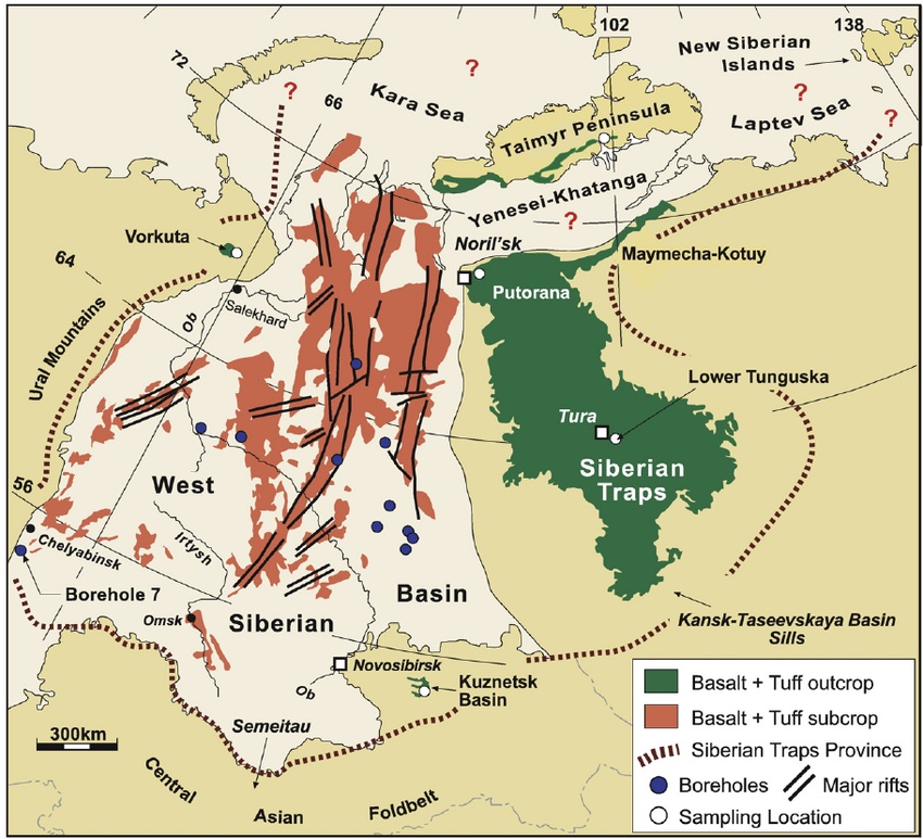
The extent of the Siberian traps. Source: Reichow et al. 2009, Earth and Planetary Science Letters, 277, 9-20
The Chelyabinsk meteor was by no means the first major event in the region. A very long time ago, the Earth here was burning. Lava came out of the ground and buried a quarter of Siberia under a kilometer of basalt. This was the famous Siberian traps – apart from the damage to Siberia, it wiped out almost all life on Earth. The entire train journey from Yekaterinburg (or Chelyabinsk) to Novosibirsk, with those millions of small birch trees (berezkas – the importance of this tree shows in the name: many languages use essentially the same word, showing that the name is older than any of those languages), had been on the buried platform of the Siberian traps. The taiga of birch trees and pines was growing on an unforgiving land.
In west Siberia the traps are buried under more recent sediments. Surface outcropping of the Siberian traps occur further east, indicated by green on the map below. They are centered on the area called ‘Tunguska’. This region is famous not for the Siberian traps – as it should be – but for a much more recent disaster. It is the location of another celestial visitor, one more damaging than the Chelyabinsk meteor. It became known as the Great Siberian Meteor of 1908; it is now more commonly known as the Tunguska event. Siberia does collect famous catastrophes.

Chelyabinsk
The meteor was about 20 meters across when it began to enter our atmosphere. It came in from the east-southeast, traveling at an angle of 18 degrees with the horizon. It first became visible at a height of 100 km, while moving at a speed of 15 km/s. The shockwave formed at 90 km. At 83 km height it began to lose fragments, and this worsened at 54 km. Peak brightness occurred at 30 km height; the meteor disintegrated at 27 km. Because of the small size of the meteor, the fragments escaped the shock front and were decelerated individually by the atmosphere. This may have helped to limit the damage from the explosion, and it also allowed some parts to reach the ground where they could later be recovered.
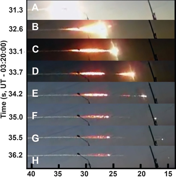
Footage of the Chelyabinsk meteor from a security camera. From A to H covers 5 seconds. A and B show the bright fireball at 30 km height when the object appeared as bright as the Sun. C and D show the secondary explosion at 27 km which is when the object largely disintegrated. Two remnants can be seen to survive in E and one in F and H. Source: Popova et al 2013, Science, 342, 1069-1073
The shock wave caused damage on the ground, mainly from broken glass. This damage occurred over an elongated area of 40 by 100 km, extended perpendicular to the line of travel of the meteor: this pattern is called a butterfly diagram and it helps to determine the direction of travel of the meteor.

Map of glass damage. The black line shows the trajectory of the fireball. Coloured circles represent town and villages with damage. Open circles reported no damage. Yellow points show where meteorite fragments were found. The contours show models for the pressure of the shockwave. White indicates the brightness of the fireball. Source: Popova et al 2013, Science, 342, 1069-1073
Directly underneath the fireball, the shockwave was strong enough to blow people of their feet and push in ceilings. UV radiation from the flash caused sunburn as far away as 30 km (perhaps made worse by reflection from the snow on the ground), but eye damage was avoided because people had time to look away. The heat was felt by everyone outside but it was not strong enough to ignite fires. The major cause of injuries was flying glass, made worse by the fact that the shock wave arrived as much as a minute after the flash, after the event seemed to be over and when people were not expecting it.
The energy of the explosion was around 590 kT. Most of the meteor disintegrated and evaporated in the destruction at 31-26 km, but small parts fell to the ground and one large fragment of some 500 kg fell into a lake. It has since been recovered.
The Chelyabinsk meteor was a long time in the making. It was a rocky object, which had split off from a much larger object (probably after a collision) about 150 million years after the solar system formed. About 1 million years ago it had a close encounter (probably with Earth) which made it break up further. The fragment that was to hit Siberia in 2013 was now on an orbit that took it from outside the orbit of Mars to the orbit of Venus. It hit Earth on its outward journey, coming in from the inner solar system. No one had seen it coming because it came almost from the direction of the Sun and therefore was hard to detect.
Other fragments of its parent body may still be in orbit around the Sun.
Tunguska

An Evenk family of around the time of Tunguska. Source: https://www.museum.state.il.us/exhibits/changing/journey/hunters-people.html
It happened on Tuesday, 17 June, 1908, at a quarter past seven in the morning. (If the date comes as a surprise to you, Russia still used the Julian calendar. On the more modern Gregorian calendar, the date was 30 June – Russia was living in the past.) This was the time of Tsar Nikolai II. Much of the Great Siberian Railroad had already been built, and it had opened up the region around the track. But away from the railroad, travel was very difficult. Rivers formed the main transport routes. In this region that was mainly the Yenisei and its tributaries. One of those was a river called the Podkamennaya Tunguska. Small settlements had formed along the rivers, with factories, farmers and fur traders. But otherwise the area was inhabited mainly by nomadic reindeer herders from the Evenk people (at the time called Tungus by the Russians), who did not have a written language at the time. They were not treated well, as described in a classic Russia novel ‘The gloomy river‘, telling a story from the Siberian gold rush. The area is cold, with average temperatures ranging from -25C in January to +15C in July. There is permafrost and this keeps the area swampy in summer in spite of the limited precipitation. The local taiga consists largely of pine trees, birch, spruce, willow, and larch, with a ground cover of blueberries, cranberries, mosses and lichens and with a generous helping of mosquitos.

Lower Tunguska river, running to the north of the Podkamennaya Tunguska river. The meteor hit the region between these two rivers. Source: V. Kiselev, 1989, Sovetskaia Kul’tura, 12
The explosion did tremendous damage and caused three deaths, perhaps more. But this news took a very long time to come out. A newspaper in Krasnoyarsk mentioned the event a few weeks after the event, when some news began to trickle out. They reported that in Kezhemskoye (about 150 km from the blast but the epicentre was nt known at the time) “In the morning there was a noise as if from a strong wind. Immediately behind this came a terrible blow, accompanied by an earthquake, from which the buildings were literally shaken, and it was as if a strong blow had been made on the building by some huge log or heavy stone. The first blow was followed by the second, the same strength and third. Then – the interval of time between the first and third blows was accompanied by an unusual underground buzz, similar to the sound from the rails, over which a dozen trains allegedly passed at a time. And then within 5–6 min there was exactly the same artillery shooting: followed by about 50–60 strokes at short and almost the same intervals. Gradually, the blows became weaker towards the end. After a 1.5–2 min break after the end of the continuous “firing”, six more blows, like remote cannon shots, were heard, but still clearly audible and sensed by the earth shaking”
Semyinov was a farmer, living near Vanovara, some 50 km south of the epicentre. his story was reported only after 1920:
“About eight o’clock in the morning, I had been sitting on the porch with my face to the north, and at this moment in the northwest direction appeared a kind of fire which produced such a heat that I could not stand it. And this overheated miracle I guess had a size of at least a mile. But the fire did not last long, I had only time to lift up my eyes and it disappeared. Then it became dark, and then followed an explosion which threw me down from the porch about six feet or more but I heard a sound as if all houses would tremble and move away. Many windows were broken, a large strip of ground was torn away, and at the warehouse the iron bolt was broken. ” Semyinov was found unconscious by his daughter.
Leonid Kulik in 1924 reported a story from closer to the centre of the event. It was told by Lyuchetkan:
The spot where all the trees are now dead had previously been used by a rich relative as a pasture for a large herd of tame deer. After the fire they went to find the herd and found many scorched carcasses, but never found a large part of the herd, dead or alive. Also some small storehouses in which the man used to keep implements, and so on, were all completely ruined; everything in them being either burned or melted, clothing, utensils, deer equipment, dishes and samovars, so that only a few buckets remained fit for use out of all his property.
The ‘deer’ were reindeer. Each family group of the Evenks would have some. In the summer, these were grazed in larger groups, in this case using this particular person’s pasture. This herd might have been 20 or 30 strong.
(The main source used for these quotations is Jenniskens et al. 2019, Icarus, 327, 4-18)
The shockwave covered a long distance. Even 400 km away, fences were blown over by three or four thunderclaps, and at Kansk, 600 km away (on the new Siberian railroad), a train driver stopped his train because of the violent vibration of the air and the loud noise, and when he reached the sidings, asked for the train to be checked to see whether some of the goods might have exploded. Seismographs worldwide recorded the seismic waves (caused by the shockwave hitting the ground), while barometers detected the air pressure wave. In Potzdam (Germany), the air wave was seen twice, having circled the globe. And in Europe, there was ‘night dawn’ for several days when the moonless skies were brightened by clouds of dust and ice at 80 km height.
Many of the reports were obtained only decades later while scientists were looking for the epicentre. Details may be confused: memory is not reliable over such periods of time. But there are consistent reports of extreme brightness seen even from the inside of thick tents, and of heat and fire. Very notably, there are no eyewitness reports available from near the centre of the region.
The damage near the epicentre was substantial. However, there wasn’t much property to be damaged. Tents were blown over, and reindeer were lost – dead or maybe just fled. Most of the damage was among the trees: over a large area they were just blown over. Whole forests were felled. The map below shows the butterfly pattern of the fallen trees, with the arrows showing the directions of the falls. This area is similar in size to that of the Chelyabinsk glass damage. At a distance where the latter managed to break glass, the former toppled trees! The whiter area inside the red contour is where the trees not just fell, but also were burned.
Surface burns of the trees were reported by Kulik out to the edges of the tree fall area. However, the forest had suffered a fire some decades before 1908 and those burns may have predated the Tunguska event. But the reports consistently mention the heat from the explosion, and the fire damage in the central region is from the meteor. Also be aware that in a mature, undisturbed temperate forest, as many as 30% of the trees may be dead while still standing. Some of the trees that were flattened in the Tunguska event may not have been particularly strong.
But the 1908 fire was extensive. A report from 1961 states “…distinct signs of the spreading of the 1908 treetop fire were found in the form of arcuate strips and surviving older forest to the north of the Kimchu River, at a distance of 1 to 2 km from the bank, in the stretch from Lake Cheko to the extensive marshes on the left side of the river. In this area the fire spread from south to north. Indications of the fire’s spread were found on heights to the north of Lake Cheko, as well as on the western slopes of hills 373.6, 491.0 and 476.0. From here the boundary of the fire area can be traced easily along an arc from the mouth of the Chavidokon River to Mount Shakharma. The surviving traces of the fire-line advance indicate that it spread toward the west and southwest, i.e., as if from a central depression. The treetop fire here gradually changed into a ground fire, with some damage to the old forest. On the northeastern slopes of the heights where the headwaters of the Churgim River rise there are arcuate strips of old forest, convex toward the south. We find identical signs of the spreading fire on Mount Shakharma, but facing east… The old forest remained intact only in narrow strips along the banks of rivers with highly developed valleys and in the form of solitary trees in the midst of swamps and rock streams.” (http://www.defendgaia.org/bobk/tungmet.html)

Map of the tree fall and tree burn area
The yellow dots on the tree fall map show the locations of known eyewitness reports. They are near the edge of the tree fall area, but not further in. Perhaps that is because people there did not survive. There are a few casualties reported in the oral stories, but perhaps there is a message in the gap of records.
History
But why did it take such a long time for the reports to surface, with all the risk that memories had become distorted or were reported only second-hand? In 1908, few people seemed to have realized that something significant had happened. There were a few notes in the Russian Bulletin of the Central Seismic Commission, which probably was not widely read:
June 30, Town of Kansk. The first shock caused the doors, window and votive lamp to shake. Subterranean rumblings were heard. About 5 to 7 minutes later there was a second shock accompanying the rumbling. A minute later there was a further shock less severe than the preceding two. It is stated that the earthquake was accompanied by the fall of a meteorite near the village of Dalaia. Peasants relate that 70 km north of Kansk in the Ustianovski district there was also an earthquake accompanied by subterranean rumblings.
June 30. Kuriski-Popauich Village; District of Kansk.-At 0 h. 37 m. a severe earthquake was observed in the vicinity of the village. After this there were two loud bursts, like the firing of a large calibre gun near Lovat Village. It was afterwards found that a large meteorite had fallen.
(The times in these reports are given in GMT). The earthquake was also registered at Tiblisi, Tashkent and Irkutsk but the relation to the meteor was not generally recognized at the time. Only the director of the Irkutsk Observatory made this connection. He determined that the stone had fallen near the Podkamennaya Tunguska river, 600 km from Kansk. No one went to have a look: the area was too inaccessible.
Leonid Kulik became interested in 1920, and he found the funding to go to Kansk and collect more information about the event. Among his findings is the following report, which reached him in 1924:
A certain N. N. Kartasheff states: ” According to Ilia Potapovich, a Tungus living on the Teter River, his brother (now an old Tungus, speaking scarcely any Russian, who was seen by Kartasheff) was living 15 years ago on the Chambe River when a terrible explosion occurred. The force of the explosion was such that for many versts along the Chambe River trees were uprooted on both sides of the river. His brother’s tent was hurled down, the wind carried away the top, deafened his brother, dispersed his reindeer, which, when he recovered his senses again, he could not collect, except a very few of them. This all affected him so much that he was ill for a long time. In the part of the forest which was uprooted a big hole appeared in one place from which a stream flowed into the Chambe River. The Tungus road formerly passed through this place; it is now abandoned because it is blocked and impassable and further because the Tunguses are terrified of the locality. There are Tunguses on the Chambe River now who could lead one to the spot. N. N. Kartasheff is of the opinion that Ilia Potapovich’s story is not true.
Kulik began to explore, and managed to finally reach the location in June 1927, after 3 months of travel from Vanovara. He found the devastation exactly as described. A summary of his ordeals was published in The Geographical Journal of March 1929:
“At Taishet the railway was exchanged for sledges and the journey was continued amid snowstorms and at a temperature of -40C through the boundless coniferous forests. From Keshma on the Angara a reindeer track through the Taiga was followed and as the party approached the region of the Stony Tunguska [Podkamennaya Tunguska], they were struck with the frequency of burned patches in the forest. Reaching the factory of Vanovara on the Tunguska about the end of March, Kulik obtained the services of a Tungus family with their reindeer, but the deep snow made progress slow and even the reindeer path at last came to an end. By pressing on on snow-shoes Kulik reached a commanding spot whence a view to the north showed a vast snowy expanse, bare of forest, which he took to be the locality he was in search of. A further advance being impossible, he returned to Vanovara determined to make a new attempt by water, as the rapidly melting snow made land-travel impossible. Rafts were built, and the ice-obstructed streams were navigated with the greatest difficulty, the men having frequently to carry the baggage on their backs through the rapids. Pushing desperately on, Kulik took notice of the varying directions in which the trees had been prostrated, and at last convinced himself that he had actually crossed the spot on which the meteorite had fallen. The heated gases and solid particles must have spread out in all directions from the point of the impact, carrying devastation around, and either overthrowing the trees of tearing or burning off all their branches. About ten shallow craters were found, with diameters of 10-50 metres and an average depth of 4 meters, their bottoms being covered with bog-moss. The traveler was almost at the end of his resources and was quite unable to excavate the ground in search of fragments of the meteorite. He reckons the area affected by the tornado at hundreds of square kilometers.

Kulik’s house in Tunguska. https://www-th.bo.infn.it/tunguska/tu99foto.htm
Kulik’s reports drew widespread attention. C. Cave in 1930 heard about the report and linked it to the peculiar, unexplained air waves which had been seen in the UK in 1908. F. Whipple picked up the story: he publicised the evidence for ‘the great Siberian meteor’ to the English-speaking world. From here on the Tunguska event became known to the world.
Track
The oral reports left the actual trajectory of the fireball unclear. This was for two reasons. The meteor had moved very quickly across the sky, in just a few seconds, so few people would have caught the movement itself. By the time they looked up, only the trail was visible (as in the Chelyabinsk videos) but not in which direction along the trail the meteor had moved. The second reason is the wide region over which the meteor was seen. As many had seen the event from a considerable distance south, the oldest publications said that it had come from the south. The butterfly pattern shows this is not correct: the travel was closer to east-west.
Arguments have been made for the bolide coming in from either the west or from the east but the old oral reports do favour a direction coming in from the east. The angle of entry is best determined from where the meteor was visible and where it was behind mountains on the horizon. The combination of all show that the meteor came in from just south of east, and travelled at an angle to the horizon of about 25 degrees. This trajectory is in fact very similar to that of the Chelyabinsk meteor.
The orbit of the original body was not identical to Chelyabinsk: the orbit was slightly more elliptical, moving between the asteroid belt and a bit outside of the orbit of Mercury. Like Chelyabinsk, it came in from the general direction of the Sun: the Earth was hit while the object was returning from a sojourn in the inner solar system.
Explosion
The meteor entered the atmosphere with a speed of 15 to 20 km/s or more, moving fast across the sky in only a few seconds. The first visibility was at 110 km height. What happened after that is not nearly as well known as for Chelyabinsk. Reports of two objects and trails suggested it may have fallen apart part way through its descent, however this may also just refer to the debris cloud after the explosion, which can bifurcate because of buoyancy of the hot gas in the trail. Some of the descriptions mention that the fireball was red. That would have been the debris cloud, after the explosion while it was cooling.
The very strong explosion shows the full destruction at the end of the trajectory. Chelyabinsk which had an initial explosion at 30 km and the final, much larger one at 27 km. But the Tunguska meteor reached much lower altitudes. Its big explosion occurred between 6 and 12 km height.
Models indicate that as an object the size of Tunguska travels hypersonically through the atmosphere, it becomes enveloped by a shock wave which shields it from the air. Fragments that come off remain within this envelope. That is unlike Chelyabinsk where those fragments were slowed down by the air and came down by themselves.
In these models, the object begins to deform at 20 km altitude, when the sreess exceeds the strength of the material. It now behaves more like a liquid under the pressure and takes on a pancake shape. That increases the drag with the atmosphere and generates a lot of heat. The objects completely disrupts and evaporates. This happens so fast that the vapour cloud has no time to expand, and the pressure an temperature in the vapour becomes enormous. This causes the radiation flash. Th extreme pressure pushes the cloud out in all directions – some backward along the atmospheric hole that the meteor just drilled, some up and some down. This adds to the shockwave (sonic boom) which comes especially from the final part of the trajectory, through the densest air. (Note that at larger distances there may be two sonic booms for each shockwave, one at the rise of the pressure and one at the subsequent fall.) At larger distances, the impact was mainly from the sonic booms (shockwave), but close to the epicentre the downward vapour cloud may have caused winds and perhaps heat.
The burning of the trees (and reportedly of some of the reindeer) shows that the energy was a lot higher than Chelyabinsk: the explosion is estimated at 10-15 MT, which is 20 to 30 times larger. (Some estimates of the energy are much lower or much larger but these values represent the most likely range.) This generated much more radiation than at Chelyabinsk: the heat was felt as far as 70 km away, and ignited fires over a large area.
People below the explosion would have suffered from more than just a touch of sunburn. If outside, first-degree flash burn and blinding eye damage was likely. (However, many reports came from Evensk people who had been inside their tents (called ‘chums’).) The shock wave would have caused eardrum rupture, something that did not happen at Chelyabinsk. People can lose consciousness from such a shock and in fact this was reported for several people even at the edge of the tree fall region. At the centre, the shock wave may even have been lethal. The area of tree fall begins about 4 km from the epicentre: at the centre itself, trees were left standing although singed and stripped of their branches. (It is sometimes called the ‘telegraph pole region’, as that is what the trees looked like.) This pattern indicates that the explosion happened at some 8 km height, so that the shock wave came in vertically at the centre leaving the trees damaged but standing. Further out, the shock came in more horizontally and the trees just snapped.

Picture: Leonid Kulik, May 1929. https://www-th.bo.infn.it/tunguska/tu99foto.htm
The epicentre of the singed trees is 2-4 km east from the centre of the tree fall: the heat originated a second before the vapour cloud exploded, and the object moved a few kilometers in between.
The total area where the trees were flattened is about 2100 square kilometers. Some 80 million trees were flattened! But this was only discovered in 1927. The area was so remote that although an expedition had been sent out in 1921, they had not found the epicentre itself.
The epicentre is in a crater-like valley, which may be one of the central craters of the Siberian traps. Clearly this is a spot that attracts double trouble and it is one to avoid! The 1927 expedition of Kulik described it as:
The outer fringe of the “windfall” bears traces of a continuous burn from above. Moreover, the branches of fall trees, as well as those which still remain standing, are, as a rule, broken and destroyed. Every surface of a break bears a little bit of charcoal. There is no break without a burn. The central area of the “windfall” lies on permanently frozen, hilly peat mosses which alternate with swamps among the hills. This central area is surrounded by burned trees, still standing but totally devoid of branches. (Kulik 1938: https://adsabs.harvard.edu/pdf/1938ASPL….3…78K).
This description indicates that the central area had not been particularly hospitable before the event, and perhaps was not or very little occupied. This may have limited fatalities to the three we know about. However, the lack of reports from within the tree fall area is very notable. There were no survivors in this region, but whether this is because everyone died or because no one had been there is not known. There is one early report which states that several families on the Taimur river perished, but we don’t know which river this was. (A Siberian taimen is a 2-meter long(!) type of salmon which was widely distributed along the main rivers of Siberia.)
Why the evidence for burning on the breaks in the trees and branches? This was not due to the flash, as the shockwave arrived some time (15-30 seconds) after the flash. It indicate that material had caught fire. This is most likely the dry moss (this being summer) on the trees. The trees themselves did not catch fire. At the outer edges of the tree fall region, some of the charring may have occured decades earlier, during a forest fire.
On the night after the explosion, high altitude clouds brightened the night skies in Scandinavia and Scotland. The clouds were white to golden and so bright that it was possible to read by the light, even though there was no moon. (It was two days after new moon.) In Gothenburg, the light appeared an hour after sunset and lasted until 2 or 3am. In Stockholm, the luminous clouds covered only part of the sky. Aberdeen too saw the white night light. Greenwich reported a bright sky in the north. The luminous clouds were seen over three nights. But elsewhere in Europe and in the US, these clouds were much less bright or not seen.
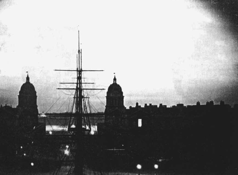
A photograph taken on the night of 30 June at Greenwich Observatory,. The ship is the ‘Fame’, used for training purposes (and located on land)
The explosion caused an atmospheric pressure wave which was detected in various places in Europe. Below is a trace from Petersfield in the UK. It shows two distinct waves, an early one with a slow fluctuation and one arriving 15 minutes later which fluctuates much faster. The first travelled at a speed of 323 m/s, the speed of source in the troposphere. The second one travelled at 308 m/s, and apparently traveled through the stratosphere.

The air wave seen in Petersfield. Although this disturbance was noted by N. Shaw in 1908, the cause was not realized until 1930! Source: F. Whipple, 1930>
Debris
Kulik reported that there were some ten small cone-like craters, 10-50 meters across and 4 meters deep, in the cemtral area. He thought that each was caused by a fragment of the meteorite. But no debris was found, in spite of several searches. This is in contrast to Chelyabinsk where many fragments and one large piece were recovered and in some cases being offered for sale.
A 2-meter boulder was found in the permafrost close to the site of the eruption. This ten-ton quartzite boulder became known as ‘John’s Stone’ and was proposed to be a remnant of the explosion. However, quartzite is not found in meteorites, and the alternative suggestion that it came from Mars was not too plausible, to put it midly. (Tsunguska has a tendency to attract the wildest speculations, from people with a healthy imagination but a more limited grasp of reality.) Instead, the rock seems to be related to the Siberian traps, where silicate dissolved in hot water and became deposited on this rock.
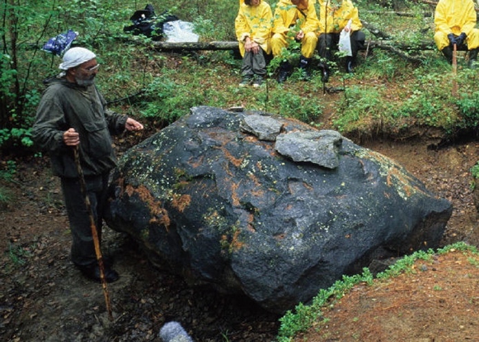
This is not it. A stone found near the explosion site, but not related to it
Cheko Lake and Suzdalevo Lake
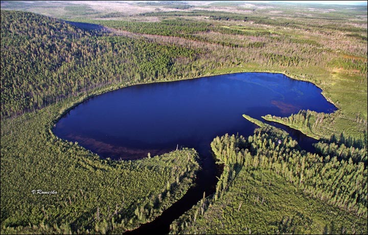
There is no obvious impact crater associated with the explosion. The area is swampy and a crater would likely show up as a lake. There are few such lakes here. Lake Suzdalevo is interesting. It is about 20 km southwest of the explosion site. In local reports, the lake is said to have appeared just after the explosion and that it did not exist before. Was it formed by a fragment from the impactor?
Apparently not. The shallow lake next to the Chamba river (the main access route to the region) is 150 meters wide but only a few meters deep. An impact structure that size would be far deeper. The sediment in the lake is older than 1908. The lake is an old river arm, not a bolide. The lake is named after someone called K. Suzdavelo, a merchant from Vanovara who visited it sometime after 1908. The story that it didn’t exist before that time may just refer to the fact that it was visited ony afterwards. The non-existence of undiscovered terrain is a common misconception.
Lake Suzdalevo. Source: https://www.natur.cuni.cz/fakulta/aktuality/archiv-2022/ovlivnila-tunguska-udalost-vodni-ekosystemy
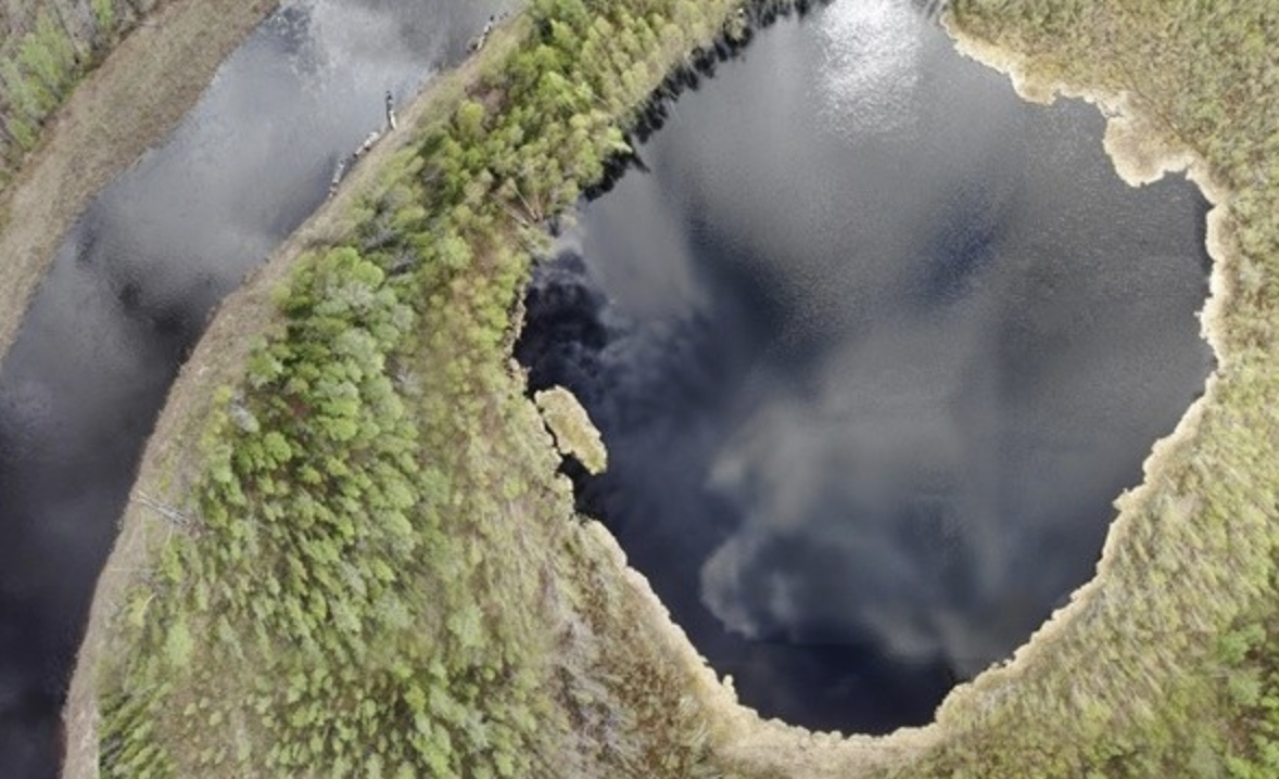
About 8 km NNW from the explosion epicentre lies Lake Cheko, 350 meters diameter. It drew attention for its shape (elongated along the trajectory of Tunguska) and its large depth of 53 meters, far more than expected in the region. It lies in the path of the Kimchu river which flows in and out of the hole. Again there were reports that the lake was recent and had not existed before 1908.
Lake Cheko
But studies of the sediment in the lake refute this. They find an age of 300 years or more. Furthermore, several lakes were found in the region which are far from the epicentre but with a similar shape and depth. The origin of Lake Cheko is still unknown, but it does not appear to be related to the Tunguska event.
Neither of these lakes has a raised rim, which is generally seen in craters. However, craters in such swampy conditions behave differently. The meteoric fragments bury themselves far deeper than in craters in solid rock. The explosion energy than becomes deposited at this depth. It excavates a cavity. The upper layers now collapse into this hole. Such a ‘collapse crater’ (which can also occur in volcanoes) do not have raised rims and have funnel shapes. Although neither of the two lakes appear to be young enough for this, the ten funnel-like holes found by Kulik in 1927 do fit the description, although with much smaller fragments. But this also failed: Kulik later found more of these holes, and excavated one. At the bottom, a decaying tree stump was found. The trees may have died in the Tunguska event: they were perhaps toppled, with the size and depth of the depression coming from the root ball. But the trees did not fall from the sky and were not extraterrestrial.
Several searches for large pieces of debris have not found anything. Instead, microparticles were found in the 1908 peat layers: metallic spherules, less than a millimeter across. Peat cores clearly show the Tunguska 1908 catastrophe layers, and these have a higher concentration of the spherules. Could these be debris from the explosion, droplets melted in the explosion? Detailed analysis showed that 90% of these spherules consisted of iron-oxide and contained no or little iridium, quite different from what is known from meteorites. The composition is in fact consistent with an industrial origin, although this has also been disputed. A second group seem to come from the continuous flux of micrometeorites which falls on Earth. That leaves a few grains which appear to be extraterrestrial but without a clear origin. These could be from Tunguska, but without dates this is hard to prove. Carbon spherules were also found in the peat but these could have formed from the shockwave impacting the peat. Tunguska destroyed many trees and stripped the bark from them, and stirred up the vegetation and the soil on the ground. Not all pollution may have come from above: there was redistribution of pre-existing pollution.
Asteroid or comet?
Without certified debris, it is difficult to know exactly what the object was. The energy of the explosion indicates that it was roughly 60 meters across, if it was a stony asteroid. An iron asteroid is unlikely, as with higher density it would have been more likely to reach the ground and leave remnants, or a crater. Such objects are also less common than stony or icy objects.
The lack of debris led to the suggestion that the object was a comet, a snowball from space which completely evaporated in the explosion leaving nothing but water This possibility remains popular. A comet would need to be somewhat larger to provide the same amount of energy: it is estimated as a bit less than 100 meters. The orbit fits with a group of short-period comets, caught by Jupiter with similar orbits. A long-period comet, such as Halley, can be ruled out though as they have very different orbits. The main argument against it that such a weak body should have self-destructed much earlier in the trajectory through the atmosphere. However the concept of comets as snowballs is dated. We now know they contain much more than water and can have a high fraction of carbonaceous material. Short-period comets also lose much of their water during the frequent approaches to the Sun.
The possibility of a stony asteroid is far from dead. The orbit is similar to Chelyabinsk and this would fit with an origin in the asteroid belt.
Models for the entry into the atmosphere find that objects of 100 meters diameters will often reach the ground (depending on incoming velocity, entry angle and strength of the object) but for 50 meters across most will not unless they enter near vertically. The object is enveloped in a protecting shockwave and can vaporize completely in the explosion. This is true for both asteroids and comets: both types can fit the event, the energy, the explosion altitude, the lack of craters, and the damage on the ground. Large airbursts can be very damaging regardless what causes them!
What happened after the explosion? The body of the meteor evaporated leaving little solid material behind. Some of the remains will have drifted down: one model predicts that the main debris may have landed some 11 km to the west-northwest. Some may have been lifted into the stratosphere by the heat of the explosion. Ice depositing on the dust grains could form the luminous clouds that caused the bright nights in northern Europe. Two US observatories found that the atmosphere was less transparent for several months after the event. This may be due to the same dust. We don’t know whether this was dust form the final explosion, lifted up even above the stratosphere, or dust lost by the meteorite during its earliest decent through the atmosphere. It has even been suggested it was dust in a cometary tail (which assumes the object was a comet) which arrived separate from the main body, but this is unlikely: the amount of material in a comet tail is very small, and the bright nights would have been seen over a much wider area than they were.
It would really help if we could find some debris, to find out what hit us. The models are not conclusive without these data. And it would also help us to determine how common Tunguska-type events are. Airbursts are not uncommon: they occur about ten times per year, of which on average 2 have an energy above 1 kT. These airbursts are much smaller than Tunguska, and come from objects 1 -2 meters across. The Kamchatka meteor of 2018 was likely about 10 meters across and was the largest known since Chelyabinsk. Chelyabinsk-size events may happen once in one or a few decades. Estimates for Tunguska-type events range from one in 300 years to one in 2000 years. Most will occur over the sea and do little damage. The risk of one hitting a populated region is not high – but it is not zero either.
Albert, January 2024

Oops – said the dinosaur


Thank you !!
Is there more than circumstantial evidence associating the Tunguska bolide with a specific ‘debris stream’ ?
This really would only apply to comets. Comet Encke has been suggested, or at least the beta Taurid swarm that has some association with it, because the time of the year and the radiant are consistent. But the evidence is limited. We don’t know the orbit well enough.
Thank you !!
By considerable coincidence, a metre-scale bolide recently blew over Berlin, scant hours after being spotted…
Wow, that is really interesting! Thank you. These poor shocked people in the video…
They surely have thought to a nuclear war event …
The first clip shows people talking about the trail being like Sputnik!
Good article, unfortunately the remoteness of the place of the event prevented any tempestive act of research…
One of the oddest hypothesis I have read was the occurrence of a relatively smaller meteor, but built in antimatter, as an explanation for the high energy developed without any collectible debris of the body itself.
Now with satellites looking for nuclear blasts we could have many more informations. Next time we will be in !
There have been many explanations proposed for Tunguska. I only listed ones with some grounding in reality!
But… reality, like sanity, is highly overrated! 🙂
Seriously though, thank you for this superb article.
I do wonder if some small fragments of Tunguska might have survived. It wouldn’t surprise me if a pebble-sized bit or two turns up in lakebed sediment one day. I don’t think those lakes (the ones in the article) were caused by the event, but I do think that lakebed sediment might be the best place to look for fragments.
As for the abundance or Russian cameras, those are dashcams. They became exceedingly popular in Russia due to insurance scams becoming very common; people staging “accidents” of the targeted vehicle/owner “hitting” a pedestrian, who then claims injury. One clip I saw a few years back was memorable; the pedestrian feigns getting hit by the car (which wasn’t actually moving), but apparently wasn’t happy with the result so got up and did it again.
Agreed, many odd ball explanations. I think at one point someone suggested a mini black hole.
Yes,some of the explanations don’t have any reasoning in facts!
The flat earthers, conspiracy theorists etc, do more to erode science education and must be put in it’s place.
Thanks albert ( even if its not volcanic) impact events are indeed stuff of tremedous power and awe, imagine in Earths early days, when we was hit by acreating protoplanets, some as large as our moon or more in mass, the energy of it is simply beyond collossal, and is hard for me and for anyone to process. Souch events results in blinding hot rock vapour photosphere envelope atmospheres around the infant Earth, as hot as the sun, until it condense and rains down as magma. … luckly souch impacts are stuff of young solar systems in formation
How often does the 1908 s stuff happen on Jupiter? Jupiter is the largest fish in the solar system and is the most hungry for cosmic bodies to swallow. Jovian impact events are tought to be 100 s of times more common than ours. Jovian Impacts are also the most energetic in our solar system due to the very high entry speeds on Jupiter
On earth is typicaly 20 km a second, but on Jupiter its 60 km a second or more depending on angle and relative speed to the planet, so Jovian events are far more energetic, comets can hit Earth at jupiter speeds, and therefore are far worse than asteorids, if one comes into the atmosphere
Even if its moving at 30 kilometers a second or more, a moon sized planetesimal impacting the young Earth, will be creeply slow because of its huge size seen from afar, it all happens in slow motion from the view of an observer in space. Earth is around 100 moon masses and 10 mars masses, that gives the possibilty for 8 theia collisions and 80 moon sized collisions during the Hadean Era to grow the Earth to todays size.
Souch large impacts are difficult for any brain to process the scale and energy
https://m.youtube.com/watch?v=RFLUuIa8wuQ&pp=ygUmbW9vbiBoaXR0aW5nIGVhcnRoIHBhcnRpY2xlIHNpbXVsYXRpb24%3D
https://m.youtube.com/watch?v=gJdwccH37Ss
Events of Earths violent past in terms of scale, the fluid dynamics of planetary bodies are correctly calculated
Simulation lacks the blinding hot rock vapour envelope that woud result from a planet merger, but otherwise this is quite correct in terms of physcis.
Very many thanks indeed for this article Albert. You have explained something that has puzzled and fascinated me for many decades since I was a teenager in the 1960’s and first heard of the Tunguska mystery.
The meteor coming in over Chelyabinsk I remember from many videos on the news in 2013. Again I was fascinated by the dashcam footage that was in the press at the time. What I hadn’t considered was the extreme power of that shock wave. I do not recall seeing that posted anywhere. Watching that video in your article I suddenly realised the power of that was immense. That made me realise how fortunate it was that Tunguska happened in such a remote area.
About 50 years ago I was talking to an older gentleman from London and he was recalling his life in London during the blitz. He told me about how he was walking down the road on a sunny morning after a night of bombing raids. As he walked he suddenly saw a wall approximately a hundred yards away just apparently collapsing without a sound! A second later the blast wave hit him, knocked him over and deafened him. Apparently a doodlebug had come down close by and the shockwave from the blast collapsed the wall but then just seconds later the blast wave hit him and knocked him over. He was profoundly deaf for the rest of his life and had hearing aids in both ears. He just thanked God that he was still alive as he was so close to that blast.
I remember reading a theory about this years ago related to Tesla’s Death Ray, which was quite amusing. Something like Tesla trying to impress his mate adventuring in the arctic and overshot his calculations. Still not sure how he could have fired without having some sort of satellite orbiting mind.
Also if you’ve seen russians drive – you’ll understand why the need so many dashcams.
Blue lagoon opened on Saturday. Following previous reopenings we are now overdue an eruption aren’t we?
On a more serious note, I was just looking at the gps and to my eye it looks like inflation might be slowing a little in recent days. And the earthquakes have gone quiet (check for wind in Iceland and it doesn’t look stormy right now, unlike some places a bit further south)
Didn’t this happen before the first eruption in Nov? Or am I making up patterns that don’t exist?
No, I think you are right in that there is a pattern developing, but whether it results in an eruption this time, is still unknown.
“The epicentre is in a crater-like valley, which may be one of the central craters of the Siberian traps. Clearly this is a spot that attracts trouble and it is one to avoid! The 1927 expedition of Kulik described it as:”
Would be very interesting if this is the case, being so old. Does bring up the question of what volcano on land is the oldest while still preserving its original structure as opposed to a plug and dike swarm/intrusive complex. The oldest I can think of is the Brukkaros mountain in Namibia which is 80 million years old and still intact. But an intact crater of the Siberian traps would be 3x older.
The oldest impact structure that still survives (in part) is the Vredefort crater, at a bit over 2 billion years. Volcanic craters do no last as long as they are much less deep to begin with.
Thats why I was asking, because volcanic craters are surface features and erode, what is the oldest one that still looks obvious as a volcano to someone who only knows the basics.
Brukkaros mountain is looking like that candidate though, 80 million years. I do feel that such an age might not be completely accurate though for how uneroded it looks, but then Namibia still preserves Carboniferous glacial terrain at the surface, its really remarkable how little erosion has got to the area even after Gondwana broke up.
Thanks : D did not knew there where volcanic edifices that old that are still visible! Rather remakable its still even there, knowing since Namibia have had lots lots lots of diffrent climates during the last 80 millions years. Most of these 80 million years woud likley been warm and humid and rainy, and erosive, only getting really dry towards end of the pliocene .. or was it drier before than I imagined.. or dating is wrong?
Yes it’s remarkable! I had heard of it but never investigated too much, and wasn’t aware it was THIS old. It seems Brukkaros is some sort of stratovolcano or caldera carbonatite volcano with radial carbonatite dikes and two large overlapping central craters, the largest over 3 km wide, at the center of a Cretaceous kimberlite volcanic field. The crater (if that’s what it is) may have survived by being very large and deep since more than 300 meters of rock have been eroded from the area.
The best way to survive over a long time is by being buried in sediment and later eroding that sediment back to the original surface! It is the same process for dinosaur footprints. But there were many more dinosaurs than volcanoes..
Worked for the Lewisian gneiss; where the younger sedimentary cover has been removed, you can walk on a relict landscape a billion years old!
I’ve seen some, probably maar, craters in the Sahara, in Sudan. They consist of rows of linear circular and elliptical depressions along what seem to be dikes, which if I remember right some of them outcrop in nearby valleys and carry the same direction as the craters. It’s close to the caldera volcanoes of Arkenu and Uweinat which date to 45 Ma, and also to the Gilf Kebir basalt that dates to 59 Ma. So the possible maar craters I saw are probably Eocene or Paleocene. Nearby there are more than a thousand crater-like structures in Gilf Kebir that are actually endogenous and not real craters, they are probably basaltic saucer sills that may have supplied maar eruptions in the in a vast sedimentary basin and are now eroded down to theirs roots. However the possible craters I saw are in a seemingly uneroded surface of Cretaceous Nubian Sandstone so they might be original, they are not as old as Brukkaros though. Here is a hillshade map of the location:
https://ibb.co/DVRjcGD
Very interesting, I guess Africa might be the best place to look for this stuff, it is ancient and geologically very stable (well mostly) but has also got a comparitively large number of volcanoes that are lacking in the interior of the Americas or Australia where similarly ancient cratonic crust exists.
I didnt think about the last option though, which is Antarctica. Most of it is covered in too much ice to be useful but that ice also acts as a time capsule, it only flows near the edges and the interior is still or doesnt move fast enough for erosion.
Mt Sidley looks like a recently lateral blasted stratovolcano still and yet it is dated to the middle Pliocene almost 5 million years ago. It isnt nearly so old as Brukkaros but the fact it still looks even potentially active and yet is nearly older than all of the Hawaiian islands is remarkable.
This discussion has also made me wonder what is the oldest still actively erupting or at least recently active volcano too. I know Yellowstone caldera complexes often lived for several million years and the current one is over 2 million. I also saw that the modern cone of Colima volcano in Mexico is young but the complex has been erupting more or less continuously since the late Miocene, though not at the same location. The Canary islands volcanoes also live for a very long time, but I dont know if the oldest ones that still erupt are really drawing from the same source or use the same magma system as they did when young, soemthing more of a coincidental monogenetic eruption than a revival.
You could also look below the sea. There is little erosion at depth and the cones can survive for as long as the crust. Hawai’i is situated in a field of such old cones
Yes, that’s true, and actually the best place to look. Pretty sure that intact Mesozoic cones and craters can be found underwater.
Was ignoring the deep sea as there is no erosion
That’s an interesting question too.
I think Gran Canaria can be considered to be one intermittently active volcano since over 14 million years ago. Fissures from Holocene eruptions radiate from the same point near the center of the island as 14 million-year-old dikes did, which was also the location of the caldera 14-10 million years old and the summit of the Pliocene Roque Nublo stratovolcano.
Valles caldera is thought to be about as old as Gran Canaria, and did a rhyolite VEI 6 just 60,000 years ago or so:
https://www.nmnaturalhistory.org/volcanoes/valles-caldera-jemez-volcanic-field#:~:text=The%20Jemez%20Mountains%20are%20volcanic,largest%20young%20calderas%20on%20Earth.
As for volcanic complexes the area of Mount Baker has remained a distinct locus of volcanic activity for 35 million years, making what is probably a series of overlapping calderas, some VEI 8 sized, that now are exposed as granitic plutons, while migrating seawards (due to rollback?)
https://tspace.library.utoronto.ca/bitstream/1807/87390/1/cjes-2017-0167.pdf
Even more interesting is the Socorro Magma Body, a deep inflating body of magma that perfectly matches with the center of the Magdalena radial dike swarm, a 29 Ma massive mafic dike swarm that is nearly LIP in size and was centered over the Socorro caldera that produced a supereruption at 32.5 Ma. Coincidence or not:
https://geoinfo.nmt.edu/staff/chamberlin/SocorroCaldera.html
https://nmnaturalhistory.org/volcanoes/socorro-active-magma-body
I lived there at one point.. There is evidence of more recent volcanics along the edges of the Rio Grande rift. There is also a large recent lava field just off the east side of the map. These volcanics are related to the current rifting, I think, and not to the ancient calderas. Socorro is fairly high on the list of US towns at risk of eruptions. But the most recent explosion is not shown ion the map. The Trinity site is southeast of Soccors
Have heard about the Socorro magma body, but it is new to me that it sits under an old caldera. Im not sure if that is a foolproof connection but certainly it is intriguing.
I do wonder too how many silicic calderas today have huge mafic dike swarms around them too that we dont see. It seems like a lot of eroded ancient calderas have wide intrusive complexes. Long dikes from Kverkfjoll and Askja go to the north end of Iceland and these are not even particularly large systems. It seems like a huge caldera like Yellowstone or Toba could have huge deep mafic dike swarms.
The connection is likely to be that, though it’s a new magma source related to the recent rifting, it has found and is exploiting an old weakness in the overlying crust.
Yes, well the caldera is uninportant. There are tens if not hundreds of VEI 7-8 Cenozoic calderas across western North America. Most of them from about 30-20 Ma. But the Magdalena radial dike swarm is the second largest mafic dike swarm of North America during the Cenozoic, after the Columbia River Basalt. And overall there are some parallels between the Columbia-Snake River-Yellowstone province, and the Socorro-Jemez Lineament-Valles province, both having a major mafic event, a line of volcanoes in the same direction, that are now mafic, and the arguably only two sub-alkaline, intraplate, silicic calderas of the planet. The later performing worse on all aspects though.
This sent me down a right old rabbit hole,
I’ll just run through the surface thoughts so that someone else can have the fun looking at wikipedia articles too if they want to.
First thing I remembered was a circular feature which I think was an article here on volcano cafe that was an eroded volcano I think in australia/africa and the thing I recall about that while it was eroded down to this series of rings it was still in good condition despite having been formed before multicellular life had evolved.
Eventually I found that article https://www.volcanocafe.org/pilanesberg-intrusions-from-the-past/ on Pilanesberg and that looks like it was 1.4 billion years ago – incidentally new scientist says that 1.4 billion years ago, days were only about 18.7 hours long.
And that also appears to be the age that the first single celled algae evolved – https://ucmp.berkeley.edu/education/explorations/tours/geotime/guide/geologictimescale.html
So if you had a time machine and wanted to go back and watch that eruption you would need also breathing apparatus – because the Great_Oxidation_Event had started only a billion or so years before, and while the oceans has oxygen in them the land surface had not rusted properly yet and so kept absorbing any extra oxygen there was lying around – not leaving enough to breath (I think the graph shows about 5% oxygen content rather than the current 21%).
That took me to the paleoatmosphere article and from there to the Carboniferous_rainforest_collapse 305 million years ago and the insane amount of detail there is on the extinct Lepidodendron, which were eventually wiped out in the Permian-Triassic extinction event 251.9 million years ago – mainly caused by the siberian traps .
That article gave me a new word Euxinia, which means anoxic sulfurous water – suggesting that if you wanted to go watch the siberian traps in your time machine you would probably need breathing apparatus there too (even if not in the direct path of the outgassing), but at least that brings us back to siberia for the tunguska event.
The question I’ve still not got my head around – if you had a time machine, what would be the earliest volcanic eruption you could go watch with the atmospheric conditions prior to the eruption being safe?
https://youtu.be/XMQKCfXRW8A?si=ojIVkznZsgySf7BY
🙂
The pressure of the atmosphere at 8000 meters is about 1/3 the pressure at sea level. Its possible to breath above this for a while but lack of oxygen will kill you eventually. Concentration of O2 is the same though so it is basically equivalent to 7% O2 at sea level. I guess to be safe any point with more than 10% O2 in the atmosphere would probably be safe as long as CO2 wasnt also too high.
https://encrypted-tbn0.gstatic.com/images?q=tbn:ANd9GcS8-UxaAK3Fj3wDTjNf8KKmC4nyP8f-GfeQjA&usqp=CAU
Apparently O2 in the atmosphere got above 10% around 600 mya and has stayed above that ever since, so basically any point at which complex life has existed would have a breathable atmosphere by that definition. CO2 percentage in the Cambrian was 4000ppm, so 10x more than today. That level in about the limit of what is considered safe with current O2 concentration but maybe would be potentially dangerous with Cambrian O2. Maybe just sitting down watching an eruption would have been fine though 🙂
The P/T had O2 of 14% and CO2 of about 2000 ppm, which is about the lowest ratio that animals with similar anatomy to todays animals have had to deal with. It would have been like being at the top of Mauna Kea but at sea level and it is 40 C instead of -4… Apparently that is the sort of thing Lystrosaurus was built for though, and it is probably also why birds have unidirectional airflow in their lungs.
In the future this oxygen curve will crash totaly, when rainfall weathering from increased solar radiation will crash the co2 levels totaly as they will be scrubbed almost as fast as the volcanoes can replace it, plants are doomed in the comming 100 s millions of years
The rate of uplift at Svartsengi acts like it’s downstream of an orifice or other pressure drop, where the upstream body has no pressure communication with it. Critical flow. The upstream pressures are such that the downstream pressure doesn’t provide any feedback. That’s the straightness of that line. The source (upstream) pressure and flow rate doesn’t care how much resistance that downstream flow has pressing against it because it can’t sense it. This would be true up to a certain pressure at which the rate of increase would gradually begin to flatten out for the downstream flow and thus the inflation. Mach in the fluid medium being transported has something to do with the explanation but my understanding of that is pretty foggy. I also have a question if these physics are only true of a system with a single orifice, or the if the pressure drop can be gradual and due to friction over a longer path with the effect of gravity added to it. I think the latter has to be true.
sounds like we need a plumbing lesson from a physicist 🙂
https://www.youtube.com/live/HF8gHPhF6MQ?si=MFPsExpy982Y7mvL
Interesting video about Kilaueas SWRZ.
1823 lava flow was modelled to have had to advance at about 35 km/hr to overtop those cones downhill. 🙂
The 1974 eruption looks very similar to Grindavik North.
Yes it was exactly the same sort of eruption, curtain of fire fissure eruption.
Except it was about 3x more intense, 6 million m3 of lava in 6 hours, but most of the lava erupted in about 1 hour at the start. So effusion rate of about 1500 m3/s 🙂
The 1974 flow advanced at walking speed nearly 10 km downslope and crept a few more km after that when the eruption had already stopped. It does put the situation at Grindavik into perspective, it is too flat to let lava flows like that happen, although a major eruption in the wrong place might not matter.
The SWRZ eruption on the last day of 1974 was preceded in September by a single day eruption on the SW area of Halema’uma’u and Kaluapele (Kilauea Caldera).
The video linked by Chad shows that the Great Crack Eruption 1823 had very fast running lava with speeds of 22mph = nearly 36km/h. That’s faster than normal humans can sprint. This was like Grindavik on high speed. A potential scenario also during the future SWRZ eruptions on lower parts.
“In 1823, an eruption caused lava to surge out from the lower section of the Great Crack and flow for about 6 miles (10 kilometers) into the ocean. The eruption was noteworthy because the extremely fluid lava moved rapidly and reached the ocean.”
https://www.nps.gov/havo/learn/historyculture/the-great-crack-and-ala-waii.htm
Can SWRZ eruptions be preceded by SW leaning Summit eruptions? 2023 already had sometimes vents on the SW cliff near Halema’uma’u. The eruption 9/1982 also happened close to the SW corner of the Summit caldera.
The Tunguska event was a severe warning to take care for the asteroid threat. It was the most famous historical asteroid impact. Were there more of similar size during the last 6,000 years of advanced human history & cultures? Wikipedia mentions the Qingyang 1490 even with 10,000 deaths: https://en.wikipedia.org/wiki/Qingyang_event
Historically the sightings of large comets happened more often: https://en.wikipedia.org/wiki/Great_comet
The probability for a relative small asteroid impact is higher than a global apokalyptic event. Worst realistic risk is something like Tunguska over a dense populated city. That would have a comparable impact to a small nuclear bomb or a firestorm.
I think the Qingyan event is an extreme giant hail. It’s the same wording used for old giant hailstone descriptions here in Spain, “stones fell of different sizes, the smallest like nuts and the largest like fruits or eggs of whatever bird”, I have read that description many times. I bet a meteor shower would bring other words to the human mind, maybe fire, dragons, or who knows what. The casualties may be an exaggeration, or maybe it was a very extreme hail in a densely populated exposed area, where a lot of people may have perished from hits and hypothermia.
There’s this presumed Tunguska-like event:
https://www.smithsonianmag.com/smart-news/destruction-of-city-by-space-rock-may-have-inspired-biblical-story-of-sodom-180978734/
Yes, I was very doubtful about the Qingyan being a meteor swarm. The description would be pretty much impossible. A hail storm is much more likely. The other story is also very unlikely. The data it is based is also queried:
https://www.nature.com/articles/s41598-022-08216-x
Quakes and tremor are likely to be difficult to see in the immediate future in Iceland. The forecast for most of Iceland is 18-25 m/s, with strong gusts. The North and northeast could be as high as 35 m/s with strong gusts. My interpretation of that, is that they are therefore sustained windspeeds. This will show an increase on the tremor plots and mask smaller quakes.
Could get a bit of motion sickness watching the webcams in windy weather 😯
Today there was a likely tecontical 3.1 earthquake close to Eldey at 10km depth, followed by some aftershocks at appr. this depth.
Looking on satellite, at Erta Ale, I could see the remnants of the 2017-19 eruption and the landscape is very interesting. Lava tubes, pāhoehoe, frozen lava lakes, rootless shields, etc.
The report of it is on the Volcano Smithsonian site here – https://volcano.si.edu/showreport.cfm?doi=10.5479/si.GVP.BGVN201804-221080
When it started, as far as I remembered, on the VD app, it was at a dark hue (major eruption), which looking back, is quite ridiculous, but I am quite surprised no one talked about (maybe because of the remoteness of it).
Any ways, here is a paper on how it might’ve happened – https://agupubs.onlinelibrary.wiley.com/doi/full/10.1029/2019GC008692
This is what Fagradalsfjall should’ve been (if it did not make the pause…).
https://dataspace.copernicus.eu/browser/?zoom=16&lat=13.60334&lng=40.66461&themeId=DEFAULT-THEME&visualizationUrl=https%3A%2F%2Fsh.dataspace.copernicus.eu%2Fogc%2Fwms%2Fa91f72b5-f393-4320-bc0f-990129bd9e63&datasetId=S2_L2A_CDAS&fromTime=2023-07-24T00%3A00%3A00.000Z&toTime=2024-01-24T23%3A59%3A59.999Z&layerId=6-SWIR&mosaickingOrder=mostRecent&demSource3D=%22MAPZEN%22&cloudCoverage=30&dateMode=MOSAIC
Erta Ales lava lake is overflowing now, rather like it did in 2017, if this keeps going perhaps the magma column coud rupture again and drain downrift into a flank eruption, 2017 s rift eruption lasted for years, we will see what will happen next
Interesting that the 2017 eruption was probably more of a vertical eruption from the deeper parts of the system that was just hydraulically connected to the lava lake. One would expect such an eruption to involve stronger fountains but all if the Erta Ale volcanoes seem to be completely effusive in the Holocene, except Dabbahu, which might imply a lava lake has existed there for millennia and completely degassed the system to great depth. Certainly at the rate of activity it has now the whole of Erta Ale itself is probably Holocene, although maybe most of the range isnt so much.
It does have two calderas, of which the SW caldera is implied to be the older one, hence indicative that it might’ve had a few magma chambers one time and said chambers eventually drained. Maybe it is like the Iceland volcanoes, instead of gravitationally draining it, it is hydraulically drained. The history should be studied a little more (if it hasn’t).
https://www.academia.edu/1080000/Regional_and_local_tectonics_at_Erta_Ale_caldera_Afar_Ethiopia_
Looks like the explanation for the caldera is kinda figured out…
Seems the caldera isn’t really a caldera, but rather a few parallel fault lines that border a depression of an active volcano…
https://www.sciencedirect.com/science/article/pii/S0377027320304327#:~:text=Alu%2DDalafilla%20and%20Borale%20have,eruptive%20stages%20in%20their%20evolution.&text=Activity%20is%20dominated%20by%20fissure%20eruptions%20producing%20basaltic%20lavas.&text=Intermediate%20and%20felsic%20activity%20occurred%20at%20all%20three%20volcanic%20centres.&text=Modelling%20shows%20compositions%20can%20be%20achieved%20through%20fractional%20crystallisation.
Paper for the geology of the northern Axial Range
I mean, a caldera is basically a circular graben or rift, so still the same kind of thing. Erta Ale does appear to have rift zones but they leak out effusive flows even at distance from the summit.
At the very least, Erta Ale does appear to be in a stage of active shield building
Had a look, the volcano at the north end of Erta Ale is Alu Dalafilla, not Dabbahu (which is a rhyolitic volcano some distance to the south). Alu Dalafilla is a weird shield volcano made almost entirely of a’a flows from intense fissure eruptions of a shallow lacolith, which forms the mountain with the name.
It and all the volcanoes of the Erta Ale range, from Dallol going to Lake Assal, all seem to be a single huge fissure volcano fed by a common sohrce at 5 km depth. The 2017 eruption was a shallow dike though modelling shows.
https://agupubs.onlinelibrary.wiley.com/doi/full/10.1029/2020JB019562
Its very interesting, most of the volcanoes are mafic shields, but then there is Ale Bagu, which is a basaltic stratovolcano, and Bora Ale which is another stratovolcano but made of rhyolite, yet looks like it is made of fluid lava. It is also highly alkaline while Erta Ale is not. Alkaline magmas tend to have lower melting points but still to get a rhyolitic volcano to erupt pahoehoe and thin a’a requires a low viscosity and extreme temperature.
Then there is Hayli Gubbi, which is to the South. Nothing known about it, except this – https://volcano.si.edu/volcano.cfm?vn=221091
Looking on the maps, it lays within a gaben, with the massive cone being the most prominent feature. Along its southern rift zone lays a series of cinder cones and pit craters all along there, similar to Kīlauea, except less active and maybe more violent even.
Regarding the southern caldera of Erta Ale, I find it curious that there is a massive uninterrupted sheet of lava that can be followed almost along the whole perimeter of the caldera and spreads around like a huge flood. It’s also strange that it’s mostly sheets relatively fluid thin lava, but there is one place near the SE corner where it turns into a thick aa that seems either more evolved or fed from high fountains. A very strange sight in a volcano that is mostly made of sustained flows of tube-fed pahoehoe.
Big speculation: Could it be a product of the collapse of the southern caldera, a huge flood that erupted out all along the caldera rim? I guess a more conservative view is that it did a vigorous Mauna Loa-like fissure from the center of the to-be-caldera, but it would be odd for it to manage such a full coverage of the flanks around the rim though.
This is also the land of laccoliths. Dallol being possibly an uplift above a magma chamber. This is more obvious for Borale where the cryptodome is surrounded by a ring of fissures. Alu-Dalafilla has an 11 km long laccolith that was tracked in action during the 2008 eruption. Gada-Ale looks like two small interconnected domes. And even Hayli Gubbi has an uplift inside its caldera.
Looking around, especially with the 2017 lava flows, there are quite a few a’a lava flows on the flanks, meaning it is very capable of doing a few more violent than usual eruptions. However, that wouldn’t surprise me that the volcanoes to the north (Alu Dalafilla) did a “violent” 3 day long eruption back in 2008. It us quite interesting that this area isn’t well studied, so there is a chance a much bigger monster lays amongst the ash and fresh lava flows. Maybe a Lanzarote or Laki scale eruptions during the Holocene could be hiding in the Afar here.
Lanzarote was not an intense eruption, so would probably require a sustained huge supply rate for several years to occur. This might be why it has only happened rarely. Actually the only examples I can think of are on volcanic islands, like Lanzarote, the other examples being some of the 1500s eruptions on the SWRZ of Mauna Loa, and the fissure eruptions north of Thingvellir and at Fremrinamar in Iceland. I know wandering eruptions was a proposed name but that also occurs in most fissure eruptions, nor the big stuff I think something more specific like ‘Lanzarotean’, the same way intense fissure eruptions are called ‘Icelandic’ even though Mauna Loa probably displays the fissure eruption style better than most Icelandic volcanoes 🙂
Anyway ‘Lanzarotean’ eruptions seem to be a thing of plume volcanics, and particularly of less active areas that might accumulate magma at the base of the crust for millennia. Erta Ale doesnt seem to fit this, its a mid ocean ridge volcano that is on land, with an open vent probably for centuries.
Dallol one of the hottest regions on the planet, even hotter than the Arabian deserts on avarge all year around: even in winter I gets 36 c readings from the area last week, which is probaly the warmest winter of any hot desert, or any fully tropical locale. Sahara is quite cool in winter, but I guess its more about its not a fully tropical desert either unlike what Afar is. The only volcanoes to visit with a harder climate is those in the Antartica icesheet.
Places like Afar and Death Valley really shows that Earth cannot have more air pressure than it already haves, otherwise these locales coud reach boiling temperatures of water, even with a sligthly increase in atmosphere pressure. Mediterranean during the salinity crisis was kilometers below sealevel and near the boiling point of water in summer. Earths seems parked close to the inner edge of habitable zone
But other exoplanets in other orbits coud benefit alot from having a much denser atmosphere than we have 5 to 7 atmospheres, souch worlds coud orbit further out to balance their greenhouse effect, a denser atmosphere have many advantages over Earths current 1 bar. But on Earth it wont work, we woud overheat too close to the sun
Indeed. However it makes orbital flight hard, or even theoretically impossible using chemical rockets. Its also likely to be hard on astronomers because the mountains will still be well under any weather and atmosphere and suspended dust levels are likely to be high, and permanently so.
There would be a great sci-fi story about a very advanced race but with no knowledge of astronomy because of this, and suddenly deciding to look at the cosmos via (say) radio waves when their religion and world view state their planet is all of existence.
Been done. Asimov’s Nightfall
Sounds to me more like the planet Krikket from ‘Life, the Universe, and everything’ (D.Adams)
Yes, it has been done but I’m not talking about a nightfall scenario. They can see suns orbiting but I’m proposing a planet with a deep opaque atmosphere so that even the concept of anything being out there is simply never a consideration. Obviously its tricky to set up without having no light at all arrive for some sort of photosynthesis but I can think of a few not-too-unreasonable scenarios. This society can be pretty advanced, perhaps near western 1980’s with some science gaps of course.
A denser atmosphere woud mean a warmer more humid global climate, with less diffrence between the equator and poles as the density spreads out the suns heat better. Oxygen and cO2 partial pressures woud be higher too, so it coud be much more habitable and breathable than what we haves, and weather woud be more stable and seasons less extreme in temperatures in terms of seasons.
But here on Earth it will not work.. as we are too close to the sun and woud overheat, but some exoplanets coud benefit alot from this
Earths current mix woud be breathable for humans all way up to 6 atmospheres of pressure like at the imaginary Super Earth world concept Lyr. It woud not work here on Earth as we woud get too strong greenhouse effect and overheat, we are simply too close to the sun.
If Earth was moved further out we coud benefit alot from having a very thick nitrogen atmosphere, it woud give us a much more even mild worldwide climate, yet having perhaps the same global avarge temperature as today. Poles woud melt and populations woud have to move inland, but the colder areas woud get livable winters with more air pressure, Scandinavia maybe woud be subtropical with mild winters and comfortable summers IF air pressure was much higher and a correct orbit woud be found for temperature balance. Given the right orbit and a thicker nitrogen atmosphere than today.. earth coud get a competely uniform tropical climate as denser air spreads the suns warmth more evenly than it does with just 1 bars of pressure
Just call in the Puppeteers, job done.
That takes me back a few years!
Thank you Albert. Excellt as always!
520,000 years ago was a huge rhyolitic eruption in the Aegean Sea with a volume of 90 km³ and tuff sediments of 150 meters. It was 10 times the size of Hunga Tonga and the tuff is 6 times of the Minoan eruption. The eruption was fed by gasrich magma. It started on a submarine vent, but quickly rushed to the atmosphere. So in fact an explosive Surtseyan-Plinian eruption. The magma had a content of 78 wt% SiO2.
https://www.nature.com/articles/s43247-023-01171-z
Nice eruption. There’s probably a lot to be found by drilling into oceanic sediments in subduction zones.
It’s quite a complicated area. The Aegean sea plate is being crushed southwestward rapidly which is causing various zones of extension in the west and compression elsewhere. Next to the eastern end of the megathrust trench there’s a gap which magma floods into including a large graben close to the Nisyros-Gyali volcanic province, where a colossal eruption occurred roughly 600ka, a VEI7 most likely.
I wrote more than half an article on this a while back but never got round to finishing, I may do one day!
Thank you for sharing your insight and knowledge with us Albert. Tunguska has been this “what actually happened” for many people. I enjoyed this long-read very much.
By chance – or by whatever – I read Siberian Times (an english newsoutlet covering Siberia) from time to time, and have seen some mention of a Tunguska/Chuko expedition there. And going back now, I see they dived into lake Chuko in feb. of 2022 if the article is correct. I don’t seem to find any published paper from this, but maybe you have seen something Albert?
“Russian scientists will be travelling to the remote Tungussky nature reserve in Krasnoyarsk region, Central Siberia, at the end of February.
A team of four received a permit to dive below 30 metres; this would be the first research at Lake Cheko at such depth. The winter expedition will start a cycle of long-term research, said Evgenia Karnoukhova, the senior inspector at the Tungussky reserve.
‘Lake Cheko is 54-metres deep. The team of researchers aim to study how thick the lake bottom’s sediments are, and take primary samples. The data they’ll gather will be analysed and passed on to geologists. We are not speaking about the search of any celestial body at this stage’, Evgenia said. ”
https://siberiantimes.com/other/others/news/first-expedition-to-depths-of-lake-cheko-close-to-the-epicentre-of-tunguska-event-to-start-in-february/
The upside down Real SLIM Shady!
https://www.jaxa.jp/press/2024/01/20240125-4_j.html (Google translated)
https://i.imgur.com/t0kzDDj.jpeg
I believe they are still hopeful SLIM wakes up again when the sun finally reaches the solar panels.
Hmm didn’t embed. Try again
Does anybody but me wonder where the landing struts on that thing are? Legs? Pads? Anything? I’m pretty sure this isn’t the case, but it seems designed to fall over when encountering the very terrain they planned on encountering.
Yes it was planned to tip over 90 degrees onto the side after landing but not completely upside down!
Okay. That explains a lot about its appearance. So it got carried away when performing the falling over bit. I caught myself before I spoke critically of the design team for failing to anticipate the failure mode. There but for the grace of god go I.
I can’t say I would have flagged it amongst several million other possibilities before launch.
So many things can go wrong in space, many with fatal consequences. When Apollo first started, the chance of success was estimated at 5%! Indeed, two very serious incidences showed the pessimism was justified. However, the very high failure rate of Moon ventures in the past decades is extreme. This is in sharp contrast to Mars ventures which have a success rate of near 100%. We spend ten times as much on each Mars mission compared to each lunar mission and it shows. I strongly recommend that the next manned mission goes to Mars rather than Moon: much safer.
I should add to this the remarkable track record of the Chinese. They do have a 100% record for their lunar missions. In fact, almost all successful moon landings are theirs! So if you want to go to the Moon, go with the Chinese.
It was supposed to land on its side, with the rockets nozzles pointing horizontally. That did not go quite to plan when the main engine failed, apparently, but I do not know the details of the landing but it seems to me that it landed correctly but with too much horizontal speed and that that made it topple: planes use wheels to prevent that from happening! The two mini beasts did get out: they were ejected at the last moment before the landing, and so the craft was probably oriented correctly at that point.
Well, almost 100% success at Mars. However, let us not forget that the 1999 Mars Climate Orbiter burned up in the atmosphere because the navigation software had a disagreement with the attitude control system. The former used metric measurements, the latter imperial.
It could only happen in America..
SLIM appears to be upside down to me.
I do have to admit though being able to land upside down and still relay a picture of itself from its mini robots is pretty impressive though!
Initial JAXA analysis is that one of the two engines failed at 50 metres altitude with the descent cameras actually seeing the engine nozzle fly away. The remaining engine was able to slow the vertical speed enough for landing but couldn’t on its own cancel out the horizontal velocity so it tumbled on landing and not in the way intended.
[Mods: Just delete duplicate in moderation with wrong email address]
From a JAXA press conference “However, due to the landing conditions such as horizontal velocity and attitude exceeding the specification range, a significant attitude change occurred after landing, resulting in a stable position different from the intended one.”
I like that – “a stable position different from the intended one” 🙂
I need to remember that.
What happened to you?
Oh well, I went down the stairs but ended up in a stable position different from the intended one.
I do wonder if they’re just mocking themselves trying to sound as factual as possible. 😀
Better than a ‘rapid unscheduled disassembly’. Chalk it up to the Japanese – they got a rover onto The Moon despite a weird landing. Good luck to the mission.
It toppled. Not that unusual for landing craft, actually. It has happened before. Engine failure during the descent is normally terminal, so it could have been worse but I would not call it a success.
From the image it seems they landed inside the crater, on the slope. Not sure whether that was intentional: I expect they targeted just outside the crater.
When ARPA was developing what would become the internet, they had to ship these phone booth sized modems (called IMPs) across the U.S. The following is from “Where Wizards Stay Up Late,” Katie Hafner, 1996
—–
Once the IMP was crated, Barker took a red Magic Marker and in large letters wrote DO IT TO IT TRUETT on the side of the crate. It was loaded onto an early-morning flight out of Boston’s Logan Airport, and Thach was there to meet it at LAX that afternoon. When he arrived, accompanied by a freight mover, he was relieved to watch the crate come off the plane but appalled when he noticed that Barker’s message to him was upside down. “Somewhere along the way, the IMP had been inverted an odd number of times,” he observed.
—–
Analysis with translation of the press conference and slides.
Japan Finally Reveals What Happened To Their Lunar Lander! And It Really Did Surprise me!
– Scott Manley
Looks like all my links for the 4 and 8 hour Reykjanes GPS plots are down, anyone else having the same issue?
Yes. 🙁
Same.
Yup.
Same here. Read something about power outages today in Reykjavík. Perhaps it is related?
There were 3 hours of disturbance from about 2.30 this morning. That must have been when the very strong winds hit.
That was disturbance on the high pass plot.
https://www.jpl.nasa.gov/news/after-three-years-on-mars-nasas-ingenuity-helicopter-mission-ends
After its 72nd flight on Jan. 18, 2024, NASA’s Ingenuity Mars Helicopter captured this color image showing the shadow of one of its rotor blades, which was damaged during touchdown. Credit: NASA/JPL-Caltech
Hats off to a superb NASA team and their little helicopter that could. 72 flights on an alien planet and it worked out of the box. Amazing stuff!
It’s still a wonder to me how, considering the amazing competence of the engineers on these automation-spaceflight projects, they always seem to play second fiddle to the human-spaceflight folks.
I notice that the Kilauea lava lake surface has increase by 10cm this week after slowly slowly decreasing for a while (cm by cm).
Could this the the first indication that magma is rising and putting pressure on the crust over the lake…and therefore an indication that an eruption will occur as soon as the pressure exceeds what the crust can hold?
Wouldnt expect it to be a sign like that, the laser rangefinder points at a part of the lake which wasnt touched directly in September so possibly is weighing down, or maybe there is accumulation of degassing volatiles under that part of the lake crust which might mean if the next eruption is in Halemaumau again the start will be rather violent and with huge initial fountains 🙂
The amount Kilauea has inflated since its last eruption is extraordinary though, at the summit there has been 30 cm of extension across the caldera, and about the same in the vertical. The SWRZ has spread apart by about 30 cm at least too and with even more uplift than the summit. And now the seismic swarms have slowed but the south flank seismicity has increased and possibly so has southward slipping.
Kilauea is doing the same thing it was doing between 1975 and 1983, filling in the gaps. If the supply remains high then in a couple years time we could get some major activity after all the underground is filled in. Its the same idea as the rifting in Iceland but much larger in scale. It wouldnt surprise me if another open conduit forms somewhere in the next couple years and we get another Pu’u O’o
Specs for Kilauea since the end of 2018 eruption, 5.5 years or so.
204 million m3 / 0.2 km3 of lava erupted.
+40 cm uplift at HVO/U’ekahuna (80% of 2018 drop)
+90 cm uplift at Keanakako (50% of 2018 drop)
+70 cm uplift at Kilauea Iki (40% of 2018 collapse)
Basically Kilauea is about half way recovered from 2018.
But there could still be some short-term events when the amount of input exceeds the ability of the ERZ to absorb it–1977 and 1979. Going back to the 1960 to 1969 period, there was the ittybitty 1961 dike event where only ~1% of the intrusion erupted.
That is probably true, but such activity would probably be similar to what was seen at Grindavik where an intrusion happens that then subsequently erupts again. Which is basically the activity of 1961-1969.
But Pu’u O’o basically just happened… There were a couple intrusions on the ERZ between 1975 and 1982 but most of the activity was centered at the summit and SWRZ, which sounds familiar… 1977 never had the transition from evolved rift storage magma to primitive summit magma despite being a relatively large eruption so might have been fed by a magma body in the rift that was depressurized in 1975 and ruptured after further flank movement.
Recently the DEVL GPS station looks the most inflating station of Kilauea. It is on the half distance between Mauna Ulu and the Summit. Maybe an indicator that the region between Mauna Ulu and the Summit may get next intrusion/eruption. The long eruptions of Mauna Ulu and Pu’u O’o let us easily forget the many short eruptions on ERZ:
DEVL is at Devils Pit, which is above the ERZ connector. The connector is open and presumably responding to the same pressure causing inflation at the summit and SWRZ (which are still inflating just not making seismic signals).
The big question is when will the ERZ proper become connected again. It was active after 2018 up until the September 2021 eruption, it started deflating when the SWRZ woke up in August 2021. There has been continued south flank movement though, as Pu’u O’o shows rift zone contraction which would not be the case if the rift was static.
The recent uptick in south flank quakes noted by Hector does show one concerning sign, the quakes are numerous all the way east to north of Kaimu, meaning the ERZ is active tectonically to a greater distance from the summit than Pu’u O’o. This will probably require a lot of magma to fill, if the ERZ conduit unblocks then it is actually not unreasonable Kilauea might stop erupting for a few years even to 2030, analogous to the time before Pu’u O’o. But then, when it is filled, things go from 0 to 100, a major fissure opens in the 20 year old lava east of Pu’u O’o, or even further east of that in the Wao Kele O Puna reserve. Before that happens I still think a SWRZ intrusion is probable, and an eruption being a likely but not guaranteed outcome. Further eruptions in Halemaumau are likely too. But Kilauea is geological time in human timescales, what was true 3 months ago has now changed again 🙂
Can the upper ERZ craters (f.e. Hi’iaka) get eruptions if the connector towards the middle ERZ is blocked? 1968 there was an eruption at Hi’iaka one year before the commence of Mauna Ulu. Even 1973 during Mauna Ulu two eruptions happened between Hi’iaka and Pauahi crater as this map shows:
The map also shows Napau crater, where 1983 Pu’u O’o’s birth began. The whole landscape was heavily transformed by Mauna Ulu and Pu’u O’o. Before there were many smaller craters. Does this show that small eruptions on variable sites are more typical on ERZ than the longterm and voluminous eruptions of Mauna Ulu and Pu’u O’o?
The small etlruptions are always more likely because a big eruption starts off small too and at that stage it is easier to stop than keep going. But if supply is high the fissure erupts again before it can solidify. Pu’u O’o fissure had major activity for a few days but after that the fissure line stayed hot, glowing cracks and occasionally tiny eruptions. Then it had another major eruption a month later, and again about a month after that. Then it went something like 70 days before episode 4 and the vent location moved, Pu’u O’o formed at this spot. GVP actually has a great catalogue of all of this.
The chance of an eruption near Mauna Ulu is low though, because that area is higher elevation than the floor of Halemaumau. If a dike did happen there it would be very tiny if it managed to surface at all. The SWRZ connector is right now the only part of the magma system that goes under an area that is lower elevation than the floor of Halemaumau. If the ERZ opens up to beyond Makaopuhi crater then the situation would also change.
Something I have not considered though, Mauna ulu was right after the summit eruption of 1967-1968, which managed to fill in Halemaumau to where its floor had an elevation of about 1100 meters. It partly drained in the 1971 SWRZ eruption as the remaining liquid in the 1968 lake flowed into that dike. Mauna Ulu did restart but in a sluggish manner at first. Pu’u O’o forming where it did was probably for the most part because of the 1975 quake but I do wonder if the 1967 eruption didnt happen would Mauna Ulu have actually formed east of Napau too, where all the major fissure eruptions on the ERZ were already in the 1960s.
Speaking of which, Kilauea is having a fit at the summit.
New pulse of magma down the SWRZ it appears.
They’re all pretty shallow too.
Pretty much dead quiet North of Grindavik for going on 18 hours. Svartsengi still inflating though. Doesn’t feel like we’re due a quake storm, but then it didn’t feel especially like that before the last one. We could have simultaneous monster eruptions elsewhere right now and I would still have my eyes glued to this little patch of Iceland. I’m wrapped up in this story I guess. It might be because of the people involved. Like plenty of other amateurs, I feel like Þorvaldur Þórðarson is a personal friend. He’s very easy to like, that guy.
Keep the other eye on Grimsvotn. I give it three months
Does Carl still has a bet on the time of Grimsvötn’s eruption?
I’ve added that date to my diary. When the time comes, I’ll eagerly wait for the eruption! Unless Grimsvotn has to put off the date for, say, a dental appointment or something. 🙁
Earth hit jupiter at 60 km a second the ammounts of energy released woud be around releasing the energy equivalent to 2,500,000,000,000,000 gigatons followed most likely shortly thereafter by a ~5,000,000 gigaton hydrogen explosion as the enormous heat of the kinetic impact causes Jupiter’s atmosphere to react with the ~1,200 trillion metric tons of Oxygen gas from Earth’s atmosphere. This whole merger is equalent to 11 months of the suns full, whole total energy output it, woud be much brigther than the sun as well. Jupiter woud be covered in a hot atmosphere of rock vapour for a long time , and possibly the whole Jupiter envelope woud be heated to hotter than most star surface temperatures, Jupiter woud expand in size with the added kinetic heat.
Due to Earths large size it woud all go in slow motion too if you saw it from perhaps ganymede, so much energy woud likley be released, when earth plows into Jupiter that the moons icey outer mantles woud perhaps liquify and vaporize. Earths life woud be killed as soon as Earth hits the jovian stratospause relasing obsene ammounts of kinetic energy. A white hot blinding tsunami envelope woud spread all over Jupiter. Forces that are diffcult to imagine, but fun to play with…
Planetary formation is an insanely violent process, so violent and energetic that its diffcult for any mind to even imagine souch forces. This scenario happened many times in Jupiters youth when the solar system was young and kaotic and planets where colliding frequently. Jupiters fuzzy dense large core many thinks are the remains of a Super Earth that Jupiter swallowed in the hadean era. We dont have any Super Earths in our solar system, and that is kind of strange, many astronomers blame the early migrating Jupiter of kicking our Super Earths that we may have had, into the sun or out from the solar system. A large planet hitting the sun at 600 km a second.. is even more.. mind difficult to render what it woud be like energy wise
Jupiters atmosphere thats above its clouds woud be similar to the diameter of Enceladus in height I think. So any planet or asteorid cannot get lower than that without armageddon, not much air density is above the jovian tropospause, but there is defentivly something there. Jupiter is a gas giant, but hitting at over mach 200 woud not matter so much with composition, with increase of density further down, the result is still an enormous explosion
Jesper, any idea on how Uranus got tipped over? (and its moons too?) This is the only planet which has an orbital tilt almost perpendicular to the ecliptic.
Its very difficult to get a planet to tip over and specialy if its very massive and not solid like Uranus. The maths simply does not work using planetary collisions in simulations, its simply not realistic. The gravity tides from the other Gas Giants probaly tilted over Uranus on its side, its orbital dynamics, very subtle rather than something dramatic like a big smack
Jesper:
Thank you for your reply. I agree that a collision would not do it. But how would the moons be dragged into aligning along the ecliptic of Uranus? We see later moons such as Jupiter and Saturn captured by the gravity field, so they can have retrograde orbits and also not aligned with the rotation axis. I also believe that this re-alignment took place very early in the solar system’s history.
The other theory is that Uranus had a moon that caused the rotation axis to tilt. Eventually the moon got pulled into Uranus.
Chicxulub was ”only” 100 million megatons for comparsion ..
Earth impacting Jupiter is a 2,500,000,000,000,000 gigaton blast! its competely mind – breaking even hahaha. Even if Earth is moving at 60 kilometers a second or more thats 220 000 kilometers an hour, it all appears eerlie slow from distance… because of Earths size. You coud probaly stand for some seconds at Earths north pole, when the south pole toutches the jovian stratosphere, you woud be able to think for some seconds, you coud walk around and think just before you are vaporized by the searingly hot rock vapour envelope that woud engulf everything. You woud also feel tremedous gravity as earth woud deaccelerate quickly, but vaporized quite fast afterwards
Jupiter by far have the nastiest impacts in the solar system, mach 200 and much more depending on relative speed and angle of the impactor, it blows my mind that the 2009 impactor that was only the size of a large ship, coud make a firecloud the size of the pacific ocean, that says something how violent jovian atmosphere entry is…
The Tunguska explosion happened close to two rivers. The temperature was likely high enough to vapour the rivers in a close zone. That could cause a jam effect on upstream side and later a potential flash flood when water returns.
Asteroid explosions are very large explosions that remind to nuclear explosions but without radioactivity. I’ve sometimes thought about a potential military use, but then they would need a standardized size and content of an artificial asteroid. Also the need for speed would be difficult.
Hello everyone, I did some carefully reading of recent NASA publications, then talked with a key scientist with GeoMapApp and she had me install their app. I was looking for submarine volcanoes in the Kermadec-Tonga arcs such that recent collapses have occurred and for any submarine volcano which could be primed to go, just like Hunga-Tonga Hunga-Ha’pai volcano. NASA asserts that maximum damage (or rather maximal km^3 displaced) for an explosion at -150 meters depth as the factors are just right for the maximual Plinian explosion.
So I loaded up the GeoMapApp and to my disappointment found that the bathymetric data is somewhat diffuse and simplified with a too coarse data grid. Does anyone know of a similar app, or data source so that more refined bathymetric data can be obtained?
It is possible to get certain data sets, but despite this, there is mention of at lest 30 submarine volcanoes on the Kermadec arc alone, with maybe 60 or so on the Tonga arc.
Some of those huge craters (like the Brothers submarine volcano) indicate very powerful explosions in the past, which I am sure has caused some cold weather spells for the planet and most likely they appear in the ice core record, Greenland and/or Antartic. I am fairly certain that they account for some of the sulfer dioxide we see in the cores.
Thank you for your reply.
Randall
That data probably doesnt really exist yet, mapping the ocean floor in detail is expensive and slow. It is also a big uncertainty if shallow submarine eruptions can put a lot of SO2 into the atmosphere, they throw up alot of water too which will probably scrub it out and likely overpower the SO2 cooling with its own warming affect.
I guess the other part is whether the magma of anywhere along the arc is rich in sulfur anyway. I cant remember where but I recall island arc volcanoes usually have low volatiles except for H2O and CO2 which are very high and are what makes arc volcanoes so explosive (especially the Kermadecs it appears, few even get close to the surface).
The volcano which has the highest concentration of SO2 in the magma is Kilauea, plume basalts in Hawaii and Iceland have the highest SO2 but are usually non explosive.
There is also crustal contamination too, which affects continental volcanoes a lot. El Chichon had very high SO2 magma but that was from contamination, the rock around there has a lot of anhydrite. The same rock layer is also what the K-Pg impactor hit…
Hekla has a lot of fluoride in its magma too, while nowhere else in Iceland does, not even the basaltic vents that erupt immediately adjacent to Hekla. So the fluoride is probably from a crustal source, maybe a continental fragment that got buried as Iceland formed and has now been involved in a new plate boundary as it shifted.
I use the following page and switch on the Global Multi-resolution Topography basemap. Watch for concentric ripples around volcanoes, those are submarine ignimbrites, and look at the majestic ignimbrite shields of northern Tonga, nothing quite like it elsewhere:
https://www.ncei.noaa.gov/maps/bathymetry/
Thank you, the Louisville Arc is new to me, but stands ouit impressively in the map, rivaling the Hawaiian chain of volcanoes in my opinion. Lots of work remains in plotting the ocean bottom.
Something I have wondered recently. There are a lot of Koa’e Kea birds that nest in the new cliffs that formed at Kilauea. HVO has a lot of images of them flying around in there even during eruptions.
But birds have very sensitive respiratory systems, they are able to breath safely in lower O2 than we can (it seems down well into single digit percentage) but as canaries in mines showed, they also seem to be more sensitive to other gases too, the birds were knocked out in situations where people holding them were still conscious. SO2 should be knocking those birds out almost immediately.
SO2 blocks UV light though, so I wonder if those birds can actually directly see the SO2 and just avoid it? UV vision is pretty much universal in birds although variable in sensitivity
Some birds but not all of them combine uv and visible light in their visual processing into seeing non – spectral colors that we cannot see, so we never really knows what colors they see, thats atudies been done on hummingbirds that have kind of evolved vertebrate insect vision because they live among flowers.
Others see uv as reflections with more human like spectrum, so yes Koa’e Kea birds probaly can see thick sulfur gas clouds in the air and avoid these areas. Many birds where male and female looks same have UV ligth markings
Regarding Kīlauea, the uplift has increased recently…
And was or currently showing a fit.
Looking at a map, some of the earthquakes were from 0.6 to 0.9 miles above sea level (0.97 to 1.45 km asl, the latter a little unrealistic) on the upper SW Rift zone.
I would watch the webcams just in case…
Although, I highly doubt it will erupt, with all the other episodes. It’ll one step closer to a future eruption, no doubt.
Nice and intense, nearly 300 earthquakes were automatically located yesterday HST. 7 microradians up in the SDH tiltmeter in less than a day, and simultaneous Uwekahuna deflation. It’s like the pulse a month ago. I hope this one lasts a bit more, the other died out too quickly.
Significant and sudden increase in Monthly Earthquake Monitoring:
Magma pulse in SWRZ connector
Here is something interesting that I noticed yesterday on the Earthquakes Canada Website (https://www.earthquakescanada.nrcan.gc.ca/recent/maps-cartes/index-en.php). These are the last 11 quakes shown; it appears that they do not update the list on weekends. There was one additional quake 2 days earlier.
What would cause such a concentration of small quakes in a short time? I’m hoping that it is the start of a magma intrusion episode similar to what happened back in October, 2007, when there were hundreds of small earthquakes that were determined to be an intrusion that didn’t make it to the surface in the Cariboo region of BC. Besides magma, what would cause these quakes, hydrothermal fluids? I’m looking forward to the next update of this earthquake list.
2024-01-26 20:08 49.834 -123.564 4.8 km 2.0 ML 32 km W of Squamish, BC
2024-01-26 18:48 49.837 -123.574 3.5 km 2.0 ML 33 km W of Squamish, BC
2024-01-26 18:44 49.834 -123.576 4.7 km 1.8 ML 33 km W of Squamish, BC
2024-01-26 17:23 49.839 -123.577 5.6 km 2.4 ML 33 km W of Squamish, BC
2024-01-26 17:16 49.848 -123.573 5 km 1.7 ML 34 km NW of Squamish, BC
2024-01-26 17:11 49.838 -123.582 7.1 km 3.2 ML 34 km W of Squamish, BC
2024-01-26 17:07 49.836 -123.577 5 km 1.4 ML 33 km W of Squamish, BC
2024-01-26 17:03 49.835 -123.577 5.9 km 1.6 ML 33 km W of Squamish, BC
2024-01-26 16:48 49.841 -123.576 4.8 km 1.9 ML 34 km NW of Squamish, BC
2024-01-26 16:30 49.836 -123.57 4.5 km 2.0 ML 33 km W of Squamish, BC
2024-01-26 16:26 49.839 -123.578 4.8 km 2.9 ML 33 km W of Squamish, BC
Fracking?
Not a chance; the bedrock is granitic at the earthquake site, but there is some volcanic rock about 30 km away.
Most likely tectonic, according to the City of Squamish website.
https://squamish.ca/our-services/emergency-program/hazards/earthquakes/
The linked site is just a generic earthquake description and has nothing to do with the current earthquakes. Did you find a reference to these recent earthquakes?
I’ve never seen tectonic earthquakes cluster so close to each other. The 2007 earthquake swarm started out much like these quakes. Here is a quote from a detailed analysis of that event: “On 9 October 2007, an unusual sequence of earthquakes began in central
British Columbia about 20 km west of the Nazko cone, the most recent (circa 7200 yr)
volcanic center in the Anahim volcanic belt. Within 25 hr, eight earthquakes of magnitude 2.3–2.9 occurred in a region where no earthquakes had previously been recorded.”
In this case, 11 quakes occurred within 4 hours. That website is https://cedar.wwu.edu/cgi/viewcontent.cgi?article=1040&context=geology_facpubs#:~:text=During%20a%2025%2Dhr%20period,1). .
Apologies! I should have suggested it as a possibility instead of what i said.
I think maybe the thought of volcanic activity there caught me off guard (love the place, family is nearby) and as I’d read that page recently, my brain just went there.
I was unaware of the 2007 swarm. Ignorant me is off to do some reading.
Thank you for the links!
Earthquake swarm in Blafjoll today near the outskirts of Reykjavik. Largest was an M2.9 at 5km depth. Also an M2.2 at 600m depth. A little like Svartsengi, this is 5km west of a series of south-west trending crater rows/fissures.
It’s had an increase in activity over the past few days. It looks like the length of Reykjanes is waking up and rifting.
https://www.usgs.gov/observatories/hvo/news/new-usgs-data-releases-available
Released data from USGS on Kīlauea.
https://www.flickr.com/photos/194933949@N05/53494407045/in/dateposted-public/lightbox/
Found this somewhere on Reddit and the persons stasted that it is the photo of the 1907 eruption of Nyiragongo. (Polished and refined).
That’s an enigmatic photo. It looks like an Etna-like paroxysm.
Pretty much. The funny thing is that, when checking the Volcano Smithsonian site in the eruptions isle, there is no mention of an eruption in November 1907, let alone something like this. It could indicate there was either a fissure eruption downslope, or it was truly explosive… (the former is more likely).
During that time Nyiragongo was in Kaiser Wilhelm’s colony, so there was a possible anglo-american blindness towards events there.
The plume is at least 6 km tall above the crater rim (assuming that’s the source) and up to the edge of the umbrella, some 9-10 km above sea level. It’s not extreme, but the lower 2 km of the plume is stuffed with black scoria, so strong fragmentation in high fountains/subplinian activity, and it’s hard to tell but it looks like scoria is showering the area to the left (west) of the volcano. I don’t think a normal fissure eruption makes such a plume.
Perhaps there where no lava lake at the summit when this happened, lava lakes tends to degass the magma supply. This excellently shows how gas rich ultrapotassic magmas are like Nyiragongos
Not strange at all, since Nyiragongo formed its steep shape through tall fountain tephra, probaly was a strong fountain in the crater floor when that photo was taken. Likey is a powerful fissure eruption in the caldera wall, forming a nice thermal column
The aggressive explosive-effusive eruption style reminds to Vesuivus which often destroys villages both by tephra/pyroclastic flows and by lava. Both are volcanoes that kill by lava which is rare in the world of volcanoes. Usually lava flows are slow enough for humans to escape. But not around Nyiragongo and Vesuvius. Both have fluid lava and steep slopes which make high speed.
Vesuvius has killed people by lava flows? Interesting, because I know that Vesuvius has killed people but mainly by pyroclastic flows/surges and tephra fall, not really lava flows. The lava flows emitted by Vesuvius is quite destructive, sure, but I haven’t heard about it killing people by lava flows. Looking into photos, its lava flows seem more akin to Kīlauea’s at best, as Vesuvius did have hornitoes at its summit at times and produced pāhoehoe flows. I did hear about Vesuvius having a lava lake too, but I am not completely sure due to its varied nature. I am curious where you heard about that?
The lava at Kilauea is slow because most slopes in Hawaii are shallow, where it flows down a steep slope the lava moves at great speed. The 1823 lava was recently modelled to have advanced at over 30 km/hr to make the flow features seen there. Nyiragongo and Vesuvius are a lot steeper than most parts of Kilauea. Nyiragongo has proven itself capable to erupt fast many times, but if Vesuvius had a high standing open vent that at times became a lava lake too then the same risk likely applied.
Many of the paroxysmal eruptions of Vesuvius had lava flows, even large plinian eruptions that also sent pyroclastic flows over the area. Maybe some of these powerful eruptions were caused by the degassed lava at the summit draining out rapidly and depressurizing the volcano, which then basically became a gigantic lava geyser.
It was thought that Vesuvius had the tallest lava fountains, but that wasn’t confirmed.
https://www.wired.com/2013/02/stunning-lava-fountains-from-italys-etna/#:~:text=To%20take%20it%20even%20higher,3%20kilometers%20(9%2C800%20feet)!
Vesuvious makes basanites, tephrites so yes, very alkaline they are highly fluid and sillica undersaturated and haves less polymerisation than subalkaline versions. Its alot more fluid than Etna and Stromboli defentivly, what lava vesuvious erupts depends how evolved it is, 79 stuff was an ultra – evolved phonolite for comparsion after a long dormancy period, the 1600 s – 1900 s eruptions involved much less evolved fluid materials, all of these magmas are very gas rich too
Vesuvius has the complete variety of all alkali magma. Often it was very fluid alkaline Foidite magma, but after long dormant periods it can erupt the alkali version of Rhyolite: Phonolite. Nyiarogongo is a Alkali Volcano on a divergent plate boundary, while Vesuivus is a alkali volcano on a convergent plate boundar (subduction).
Coud be a flank eruption too, typicaly generates similar looking condensation plumes, wont look diffirent. If its the tropospause inversion that the anvil hit, then its one hell of a tall column up to 60 000 feet or so in the tropics
Oh, it’s in german. It reads “Vulkanausbruch” which means “volcano eruption”. The other sign is the ä in the name.
I think it’s actually the November 1907 eruption of Nyamuragira. It just happens that when seen from the hilly part of Nyungo the eastern pit crater of Nyamuragira falls in the same direction as the center of Nyiragongo’s crater. GVP mentions a November eruption from the summit of Nyamuragira, classified as VEI 3, and the details: explosion, eruption cloud, and ash. As such, it was probably a paroxysmal event from what is now the lava lake in the eastern pit crater of Nyamuragira, and the plume is about 9 km above Nyamuragira and some 12 km above sea level.
I may have to kindly disagree with that. The shape itself looks more like Nyiragongo than Nyamuragira.
The explanation here – https://www.flickr.com/photos/194933949@N05/53497871971/in/dateposted-public/lightbox/
And a few features I think are cinder cones (could br wrong) – https://www.flickr.com/photos/194933949@N05/53496986302/in/dateposted-public/lightbox/
I might be starting to think this is taken on the slopes of either Mikeno or Karisimbi.
Since you did mention that paroxysm supposedly coming from Nyamuragira, I am starting to think they got the wrong volcano…
To add to this, if this was some optical illusion of a volcano erupting behind another volcano, that would mean the lake shore would be visible on the left-hand view and only one of the older cones are visible (Shaheru). In this case, based on my assumptions, Nyamuragira would’ve been out of frame to the right.
At first I thought it was from Karisimbi too, and that was why I ruled out Nyamuragira. But I looked up the name Nyundo in Google (the name written in the photo), it’s a village to the SE of Nyiragongo, some houses are built on hills and the view from those hills is similar in Google Earth to that of the photo, I think even a cone in front of it matches. From this location, the eastern pit of Nyamuragira is precisely behind the crater of Nyiragongo. It’s still a pretty amazing find, I had no idea Nyamuragira produced this kind of activity.
I am starting to agree this is taken at the village of Nyundo, since looming at Google maps (my messed up to think of Nyungo for some reason at first), I am still on the fence about the plume. I still think it is coming from Nyiragongo as it is clearly coming from its crater. On that note, Nyiragongo is 21.6 km away from the village, Nyamuragira 35 km away. You did mention in you initial observations that the plume is roughly 9-10 km. If this was Nyamuragira, the plume would have to be 16 km in height to be seen in this, or the umbrella cloud supposedly from Nyamuragira would’ve been smaller. Also, if that was the case, where are the degas plumes of Nyiragongo? They would show up well in front of this other violent plume (unless if Nyiragongo was silent at the time).
Either way, records and sparse photographs are the only evidence of the 1907 eruption. The area needs to be more studied in detail. I’ll still stick to Nyiragongo until other studies or photographs say otherwise.
Using the trigonometry formulas it’s supposedly possible to figure out how tall is the plume with:
Diameter of Nyiragongo’s crater: 1.3 km
Distance from Nyundo to Nyiragongo: 22.8 km
Distance from Nyundo to Nyamuragira: 36.2 km
I got a 6 km plume above Nyiragongo and a 9 km plume above Nyamuragira (as far as the column is visible, not considering some likely overshooting, and assuming more or less where the summit of Nyamuragira might stand in the horizon). Add 3 km for the height of the plume above sea level. I think 12 km asl is actually more reasonable, the view of the plume is similar to the 2015 Voragine paroxysms of Etna, with that dark tephra-rich bottom section and that nice although not oversized white umbrella. And the 2015 Etna paroxysms sent plumes to 15 km asl.
It’s a nearly unbelievable that it would rise so perfectly behind Nyiragongo’s silhouette, or maybe it was purposeful, but Nyamuragira’s crater, in particular the eastern pit that is the seat of summit activity, lies exactly behind Nyiragongo from Nyundo.
I guess, but until then, Nyamuragira would be owner of the 1907 eruption, unless otherwise. Pretty much doing a sort of Semeru-Bromo thing in this photograph.
Nyiramuragira is just behind Nyiragongo to the west hidden behind Nyiragongos cone here
Well, I was kind of wrong. Nyamuragira would’ve been in the clouds behind Nyiragongo, but still, the plume is clearly coming from Nyiragongo. If it was from Nyamuragira, it would’ve been smaller and more distant (and only coming from the clouds a little right of Nyiragongo).
Here is a link to the original post on Reddit – https://www.reddit.com/r/Volcanoes/s/OYE3Kvrr0P
Kilauea activity has picked up again over the past hours
Wrote you a comment a little further down offering some reason for not finding any trace of meteor/asteroid in Tunguska with a paper about a long wildfire that might be accessible to you. Regards, interesting piece.
That paper is sadly inaccessible even to me. It was obviously not meant to be read. But there is a paper from the 1960’s which discusses the fire history. This area was affected by fires in the 19th century, but the 1915 ones seem ot have missed it.
I did a quick scan through the paper, but I didn’t see anything mentioned about the impact and its consequences.
It just said “Nevertheless huge portions of the forest were destroyed completely, e.g., between Angara River and Nijnyia Tunguska;” with respect to the Tunguska area.
The rest is just data about forest damage by the fires of 1915 and the preceding drought.
Concerning the Elgin Marbles – also a very intriguing piece – I wonder where the Vermont Marbles are coming from (subduction of Hudson Seaway?):
https://marble.com/articles/about-marble-and-granite-quarries-in-america-#
Eldvorp GPS is getting close to the point the last eruption started at. Next eruption could be within this week.
Thing is Svartsengi has now gone way up above the trigger point so to speak, which could be a sign of there being more magma available there now. Maybe an eruption up near the December fissures wouldnt reach Grindavik but lava might still, and if a dike goes south from the eruption it might spawn small weak vents well beyond the main fissure like last time.
Will the eruptions likely continue with the used size of the previous two ones or should we expect an upward trend? Maybe we only have seen the beginning and establishment of the magmatic system, but the main big eruptions are still to come.
If Albert’s theory is true about the solidified magma taking up space leading to larger later eruptions we could be in for a treat. Well if it’s around Hagafell anyway, hopefully it doesn’t bust out in the middle of the harbour.
Alberts theory is the general consensus of how these rifts work. Whether solid or not the rift fills up underground and thus an intrusion of the same volume later will erupt more with less space underground.
Basically every line of evidence suggests the activuty we have seen so far is minor by comparison to what we should expect these systens to do, unfortunately. If you want an idea then paste the Eldvorp eruptions lavafield over the current fissure and that is pretty close.
There’s been a couple oof interesting earthquake swarms in reecnet days…
East of the Apaneca Range volcano there’s been around 80+ earthquakes in the past few days.
East of Edgecumbe volcano there was a smaller swarm (I think they’ve only recently added a lot of monitoring equitment because of the steady inflation over recent years).
Apologies for the spelling mistakes. My keyboard keys are getting worn out.
I have what maybe is a stupid question. I would think that once a dike fills and propagates to the surface that a significant weakness is created in the crust that would take much less force to re-open. But in the recent volcanic eruptions in Iceland, it seems like the magma almost goes out of its way to erupt somewhere else.
Is there a physical separation of many pockets or something? It almost seems like a bunch of corn kernels or something where one can “pop” over its small region but that this doesn’t mean the next kernel over will “pop” except that the general environment is conducive for popping.
Just curious and figured someone here would know.
It is the difference between force and pressure. Once the magma in a dike begins to solidify, it remains a bit ductile, i.e. while it is still warm it can adjust it shape a bit. Now you try to get in, but this substance resist byt spreading out the force over a large surface. Cold rock cannot do this, so you apply a force and all the force starts pushing at a small crack. In the first case the pressure (force per surface area) is low. In the second case it is very high. It is the difference in being stepped on by a person in flat shoes and a person ion high heels. So the cold rock is actually easier to split. It doesn;t work while the magma is still liquid since the new magma just mixes with the old.
When a dike formed it probably cracked the rock in a number of places. The next intrusion may well take one of those cracks as its route to the surface
I’ve been imagining the cooling magma in the fissures as sort of glue-like. Or goo. Or one of those puttys which are ductile but become hard and stiff under pressure.
Like tearing a paper envelope as against tearing a plastic one.
Once started the paper tears easily, but the ductile plastic one just stretches and is a ‘%$*&£** to get into.
That is a fantastic and clear answer, thanks! Makes complete sense. You’d think someone who deals with glass all the time like me would get that up front!
There might be little evidence as the event took place in 1908, was probably forgotten due to the Messina Earthquake with an estimated death toll of 75 k by tsunami, then there was WWI. Finally some research began in 1927. In between there was a 50 day wildfire in the area in 1915:
von VB Shostakovitch · 1925 · Zitiert von: 45 — portions of the forest were destroyed completely, e.g., between Angara. R•ver and Nijnyia Tunguska; about half-way up the Ob River and its
https://academic.oup.com/jof/article-abstract/23/4/365/4752947?redirectedFrom=PDF
I myself cannot get at it, but maybe the author by his institution. That fire is supposed to have destroyed much of the area, debris might have been buried or washed down by rivers later.
So, basically, in a remote area like this one it is really difficult to find prove.
I am also interested in the Popigai Impact in the north which has an impact crater and was therefore found.
There might be little evidence as the event took place in 1908, was probably forgotten due to the Messina Earthquake with an estimated death toll of 75 k by tsunami, then there was WWI. Finally some research began in 1927. In between there was a 50 day wildfire in the area in 1915:
von VB Shostakovitch · 1925 · Zitiert von: 45 — portions of the forest were destroyed completely, e.g., between Angara. R•ver and Nijnyia Tunguska; about half-way up the Ob River and its
https://academic.oup.com/jof/article-abstract/23/4/365/4752947?redirectedFrom=PDF
I myself cannot get at it, but maybe the author by his institution. That fire is supposed to have destroyed much of the area, debris might have been buried or washed down by rivers later.
So, basically, in a remote area like this one it is really difficult to find proof.
I am also interested in the Popigai Impact in the north which has an impact crater and was therefore found.
Writing this the second time here as I am not sure whether I used the right e-mail-
Looks like some of the quakes on Kilauea migrated down parts of the SWRZ.
Only quakes or magma too?
Kilauea seismicity seems to be coming in bursts, with intense seismicity followed by aseismic or nearly aseismic pauses. I’m not sure how to interpret this:
Instrumental drop-outs?
The HVO seismometers have been weirdly cyclic for as long as I have watched, although it usually drowns out completely if there us something volcabic happening.
There probably is an episodic flow of magma to the SWRZ right now though, an eruption seems likely soon but Pele is being a lot less predictable than she was last year, a SWRZ eruption might still be months off.
The SDH tiltmeter is still going up while this is going on. Either this calms down or something breaks. Either way, it’ll have to break sometime.
We now have about 3 mag 3 earthquakes at the summit.
It’s just surpassed 350 automatically located earthquakes in 21.5 hours, I think it’s the highest we’ve seen since the 2018 eruption:
https://www.usgs.gov/volcanoes/kilauea/science/past-week-monitoring-data-kilauea
The earthquake activity has gradually migrated downrift from its initial focus in the southern caldera rim and has now reached Kulanaokuaiki Pali (MITD seismometer). It comes in pulses, breaks in activity are associated with very rapid summit reinflation, followed by resumptions of summit deflation and seismic activity and inflation along the SWRZ connector area.
One of the stronger quakes pushed the SDH tiltmeter up about 5 microrad, usually the quakes just shake the instruments but this one made a permanent offset, this intrusion might be the one that makes it.
Nearly 400 earthquakes in a day, definitely the most intense episode over the past year period. And SDH tilting almost as fast as in early October, considering that in October the inflation locus was almost under SDH but has now moved away. I doubt this will lead to any dike or eruption though. If Svartsengi has shown something is that vertical deformation might be the best indicator of imminent eruption and the SWRZ could take a months of inflation at late-2023 rate before doing reaching pre-2018 level. And it hasn’t gotten a significant reduction in elevation like the summit has.
Since this started days ago the tilt at SDH has changed by 20 microrads: over a distance of 1 km, there was 2cm difference of inflation. At the same time OUTL has moved by about that much. But in the previous weeks OUTL inflated much faster while the tilt at SDH moved much less. So previously the whole area inflated (tilt can’t see that) but now it is more localised. The GPS’s are not picking up where the current weak spot is, but from the fact all GPSs in the area are moving south, it seems to be inside the caldera. That would fit the increase in the level of the lava lake. My guess (and it is a guess) is that the next eruption will come from the lava lake or the immediate area around it.
Volcanoes hate being predictable, so it’ll now do something else..
The area at Svartsengi is almost dead flat though, where the SWRZ of Kilauea is sloped. There is also a magma chamber adjacent.
Having a look at OUTL, about 40% of the 2018 drop has recovered, but 3/4 of that has been in about the last 6 months. So at that rate OUTL will be where it was in 2018 around the end of the year. But that isnt the whole story either, because in 2018 there had been a decade of degassing and probably all the shalliw magma was degassed. Most or all of that drained out of fissure 8. The stuff erupted since has been very gas rich, the lava of June and September was almost like foam or wet paint in the videos I have seen of it, it looks like the super hot stuff that was in the old lava lake.
Now all the pressure is going to be coming from more volatile magma, stuff which might be able to erupt where it couldnt before 2018. I expect the next eruption to be very intense, and probably a lot sooner than the end of this year though maybe not of the rift yet.
Halema’uma’u is deflating, as shown by the UWE tiltmeter on the NW caldera rim. The SDH tiltmeter shows inflation coming from the SE, so I think inflation is centered somewhere between OUTL and PUHI GPS. Southward motion probably has to do with the ever-present seaward creep.
The possible intrusion happens at around sea level, so 1 to 1.5 km below the surface. Is Kilauea’s most shallow magma chamber at this depth?
Albert (or anyone else who knows).
I tend to see tiltmeters as expressions of angle rather than differential deflection which I know others do. Is there a standard distance (1km was quoted) over which the angle changes (which also give some scale)? In this case, for all reasonable angles 1uR would equate to delta 1mm over a distance of 1km.
As a point of interest are the meters themselves actually spanning 1km, or are they in fact much smaller (eg 100m) in which case 10uR doesn’t really say 10mm, but 1mm over a distance of 100m, and could be almost anything over 1km.
They are very much smaller than 1 km. They are probably a meter long. The mounting is crucial for the stability. They are very sensitive. Look at KAE (Hawai’i south coast) for a tilt meter that responds beautifully to the heating of the ground by the Sun. The Pu’u’o’o tilt meter (when it was still active) responded to changes at the summit, and during the Holuhraun eruption, tilt meters near Hekla responded to it. That makes sense if you consider that 1 microradian is indeed 1mm over 1 km, or 1 cm over 100 km. The tilt change does not tell in itself how far away the change is happening. Nor why: rain can cause soil expansion and change the tilt, and so can sunshine.
Never thought of that, but maybe it’s worth estimating: The area that’s inflating is the same as in this interferogram:
2-3 km might be appropriate for the distance of tilt change given the tilt in question is NE from the center. The problem is that close to the center and the edges of the deforming area the tilting is less strong than in the middle circle, not sure how to account for the complex shape, though if you know the location of the inflation center, the shape, and the station I’m sure it’s easy to approximate uplift mathematically, though it’s easier to wait for the GPS to update and then figure out the uplift from there though.
SDH seems well placed where the tilting is strongest. Maybe half the rate of tilting of SDH over 2-3 km is appropriate which would give 2-3 cm uplift in the 3 days of crisis.
It’s also possible to find the equivalence between tilting and uplift of a particular source since Kilauea uplift areas are repetitive you can easily figure out which one of the 3 possible uplift centers of the caldera-Koae Fault System area is responsible for the tilting from the direction of deformation in the station.
Remember that the eruption in 6/2023 had a vent on the SW corner of the caldera. This matched with the inflation visible in the interferogram. 1919/1920 there was activity in the caldera. Here you can see a video with the vent on the SW corner of the caldera: https://www.nps.gov/havo/learn/nature/june-2023-summit-eruption.htm
This map shows the SW direction of the 6/2023 eruption:
Can an intrusion in SWRZ build a crack/graben on the surface again like 1919? 1919 the intrusion was likely relatively shallow from the summit to Mauna Iki. The present possible intrusion is likely much deeper. The present earthquakes happen below or around sea level. So still more than 1km for magma to go upwards.
It can, particularly if the summit lava lake drains into the dike like it did in the Mauna Iki eruption and 1823. We are not there yet though, this is not magma intruding rock, this crisis is probably due to magma inflating existing magma bodies; seemingly the horizontal magma sheets (sills) that run from the caldera to Kulanaokuaiki Pali about 2-3 km deep, and the dikes under the SWRZ connector 2-8 km deep or so. Hard to know how long it will take for a major dike or eruption to happen in the SWRZ. The 2018 eruption drained a lot of magma from this area as it did from the whole volcano, and the M 6.9 earthquake of that year means the flank doesn’t give much resistance to swelling of dikes under the connector, so it can be a while before the area pressurizes back. At the same time, the ERZ has low pressure, its deep rift has been spreading without much input from the summit at the expense of the Pu’u’o’o area sills that have drained down, and more than half of the 2018-2020 inflation is now gone and still draining out. The summit remains the easiest place to erupt right now due to its lowered elevation.
I’m not too sure what will happen. Maybe at some point, once the SWRZ has recovered enough, magma will start rushing again into the ERZ and all that’s left of the current crisis is just magma recharge for some far-off eruptions there or somewhere else in the volcano
And there’s also the PUHI area inflation. If the sills complexes to the SW of the caldera are related to the SWRZ connector that sources SWRZ dikes and eruptions. The the inflation SE of the caldera in the PUHI area must be related to the UERZ connector pressure build-up, which comprises the most important area of rifting and dike activity of Kilauea, and from the former Alae Crater the UERZ connector can send dikes and produce eruptions well beyond Pu’u’o’o.
Maybe the summit activity has to accelerate before something big can happen on SWRZ. The 6/2023 eruptions showed a possible SW trend of summit eruptions. We don’t know how many SW summit eruptions happened 1790-1800, they could have been an early indicator for a later move towards SWRZ. The whole area from Halema’uma’u towards the Caldera rim can be a possible place for such SW summit eruptions. It’s possible that this area has to be loaded with shallow magma reservoirs that can feed SWRZ.
Looks like the sill complexes in SWRZ are filling with magma, been many pulses, perhaps we coud get an eruption there quite soon, a 1971 or similar events woud be fun to see, these lavas are highly fluid so will form “flood sheets” since Kilaueas supply is elevated woud not be suprised if it breaks after some time more of these pulses. Coud the magma erupt at weak structure points in the koae Fault System? if it erupts it will likley be closed off since the magma flow will be very fast indeed, the deformation is very sill like, but its little west of the main summit magma chamber, or south on a globe map
Maybe the SWRZ eruptions have to be prepared. When they happened first 1790-1800, there was no scientific monitoring previously. We don’t know how the shift from the Caldera collapse 1790 to the first SWRZ eruptions developed.
Is it possible that the first SWRZ eruptions happend at relatively low altitudes on lower SWRZ? 1823 one of the lates SWRZ eruptions happened there: Keaīwa Lava Flow: https://www.usgs.gov/observatories/hvo/news/volcano-watch-most-unusual-kilauea-eruptionmaybe-1823#:~:text=The%20eruption%20was%20over%20by,too%20hot%20to%20walk%20on.
“The 1823 fissure is also unusual in having no substantial spatter deposits along its length; it’s just a big crack where lava welled up from below and then flowed downhill.”
It was in fact a quick lava flood out of the ground without the formation of spatter cones. Like a lava fissure without fountains/curtain of fire.
1823 and Kealaalea (1810s?) eruptions were from lava in the caldera flowing down a shallow level crack above sea level, same as Mauna Iki and probably also 1971. The SWRZ connector fed the Kamakaia eruptions and those hills are pretty far from the summit, about as far as Pu’u O’o. Also fed 1974 eruption too.
An eruption like Mauna Iki or 1823 will very likely happen eventually if the activity stays at the summit and it fills up more. But an eruption from the connector will be very different and a lot more intense to begin with. They can both happen close together or even at the same time too potentially, the activity in the 19th century all seems to have been within the span of a few years leading up to 1823, as evidenced by the many fuming vents seen by the Ellis expedition which were clearly not the great crack and were also necessarily young to still be degassing that way when seen.
If the whole of Kilauea caldera collapsed to the same depth as in 2018 (~520 meters elevation) then that would require about 1.9 km3 to fill up, which at the recent supply rate would take about 15 years. The caldera was also observed basically empty still in 1794 so that 15 or so years begins at least in the later 1790s anyway and maybe even beginning after 1800. If that is the case then all of the SWRZ eruptions probably happened at most in about 7 years from 1815 to 1823. With how much magma has been going into the SWRZ right now it might be that actual eruptions on the SWRZ in the early 19th century didnt really begin at all until basically right before the Kea’iwa flow, after 1820. It did seem strange that no records of any type existed of an eruption outside the 1823 lava flood but if the rift had been basically continuously active for the past year or so before and then suddenly broke out 1000x higher rate and way lower down maybe it is excusable the rest of the details are fuzzy 🙂
Yes, maybe we have to be more patient with SWRZ. The intrusions may need time to accumulate and build up pressure for major eruptions. Caldera filling in the Summit is not as far progressed as in the 19th century. So it’s possible that summit activity continues, but with a SW leaning.
The 6/2023 eruption was a SW leaning summit eruptions. Should we expect more of this? The summit caldera is big, it can have hosted many eruptions in its SW corner 1790-1800, that are buried by later events. The geological map about Kilauea Caldera doesn’t show flows of this age, but it’s possible that later lava flows (f.e.1919/1920 and 1982) buried remains from older SW corner eruptions. 1971 and 1982 showed that summit eruptions in some cases can even overflow towards the SW.
Not too sure if this is important, but this is taken at the MANE GPS device. It lays on the edge of the Hilina slump, which the GPS moves to a southeasterly manner as usual. The unusual aspect is that it is uplifting when it is supposed to to sinking (or so I thought). Here is another graph for comparison. This shows the 2018 drop, as usual.
It happens to other south flank stations near the coast as well, if you check. Kilauea’s flank moves seaward while uplifting, the M 7 flank earthquakes have a reverse focal mechanism, and the seismicity plane 8-6 km below the surface slopes upward towards the sea.
Alrighty, tank you for the confirmation. Just found it a little odd. The GPS are around these coordinates – 19.3401795, -155.2709086.
Even Mauna Loa’s station northwest to Kilauea’s SWRZ shows some change:
On the other side of SWRZ to the southeast is the HLNA station:
A bit of an update from HVO:
Activity Summary: Kīlauea volcano is not erupting. An increase in seismicity in the south caldera region that started on Saturday is continuing, but has remained steady. Kīlauea summit remains pressurized; in recent months unrest has escalated quickly, and an eruption could occur in the future with little warning.
Summit Observations: South caldera seismicity continued through yesterday, becoming somewhat more widespread, but not increasing in event frequency. In general, rates have been fairly steady since Saturday morning. Periods of increased seismicity can be expected to continue during repressurization of the summit magma reservoir, which has been ongoing since the end of the September 2023 eruption.
Kīlauea’s summit region remains at a high level of inflation. Tiltmeters near Sand Hill and Uēkahuna bluff indicate ongoing inflationary tilt localized to the south caldera area, with a steady rate. Step-wise changes in the tilt signal over the past day were due to the instrument being shaken by nearby earthquakes.
Looks to me like the 4-hour GPS cuves are flattening a bit at SENG, SKSH and ELDC. Something about to break?
I’ve been keeping an eye on the quakes too and I think we coild be days away..
Yes, uplift in Svartsengi stopped for a longer time.
The 8 hour plots are also showing it.
Could be it’s going to do a Doors thing.
(break on through to the other side)
Like it did back in November.
All GPS statuons are dipping a bit in the last few samples. That hints of a systematic error, for instance in the satellite orbits. Note that the last few samples are always based on predicted orbits. Only a few days later the data is updated with actual, measured satellite locations.
Also note that the curves have flattened many times without eruption. It’s not really a reliable sign. The only real signal that something is about to happen is an intense earthquake swarm.
IMO themselves commented on a flattening in the days prior to an eruption, as pressure increases. You do have to look at continuing trends though for the overall picture.
The large swarms have only been appearing a matter of hours prior. However, sequences of increases in activity have also been seen during the lead up.
Looks like the Svartsengi gps has stabilized back into a steady rate of inflation. The Svartsengi 8 hour chart is interesting. The line before the December eruption (Grindavik North) is curved as if indicating a loss of critical flow (Wikipedia calls it choked flow).
https://en.m.wikipedia.org/wiki/Choked_flow
After the Grindavik North eruption, inflation forms the present straight line which is indicative of critical flow (which I described, poorly, in an earlier comment). Seeing both behaviors by the same system is kind of odd, as is the lack of a readjustment for the second (Grindavik South) eruption. Of course, both behaviors could be mimicking critical flow or the lack of it without that flow condition existing at whatever depth the source is allowing upward movement of magma. My discussion of flow conditions also assumes the inflation at Svartsengi is acting as a linear bourdon tube, with each centimeter of elevation indicating a finite increase in pressure. That might not be true. The two inflationary behaviors definitely exist though, with the transition from non-linear to linear occurring with the Grindavik North eruption.
If you look at the long term trend, then yes, there is a certain slowing down, but looking at a few of the last samples won’t show it. It’s simply impossible to distinguish from measurement noise. In this case, all stations, even ones far away, showed the exact same downward trend in the last few samples. Even Grimsvötn showed it. Bottom line: subtle changes in gps readings are no good, long term trends are.
From the looks of it, we should probably expect an eruption (or dyke formation) within a week.
As for the lack of readjustment in some stations for the second eruption they were probably masked by the formation of a new dyke, which is apparent from the formation of a new graben to the east of the old one, and from horizontal movements of GPS stations. Look at GPS stations west of the sill. In December, they moved towards the deflating sill, but in January they moved west, away from the sill, but consistent with a dyke forming.
Today they’ve wonderful winter weather in the region:
https://www.youtube.com/watch?v=Bqudj0x0POA
The snow allows an opportunity to watch for geothermal heat below the surface
Tiltmeters, see fragment of long thread above.
Ok so we are seeing a movement ~1uR over 1m or 1/1000th mm (1u!), which is rather small. I will accept this as a crude measure that is “quite useful” but certainly a very crude measurement when extrapolated over many hundreds of meters.
I am not remotely surprised that surface effects (sunlight, moisture, freezing) have major confounding effects. I will also accept this is a cheap, easy to install, device and as such has great utility.
A rather better one, with say 100m baseline and ends well anchored into bedrock for accurate differential measurements would be a nice addition to the arsenal. A couple of lasers should do that quite nicely. Its basically a cheap self levelling laser level with receiver after all. Available with receiver accurate to ~1mm over 10m for a cost of around 100ukp on ebay !
I think they are underestimated actually. The Uwekahuna tiltmeter which is underground beneath the former HVO building is quite accurate. I’ve seen intrusions/magma pulses in the SWRZ connector induce deflations of about 0.05 microradians in the Uwekahuna tiltmeter. Should IMO install tiltmeters at Sundhunukur, on the flanks of the dike, they would probably gain some insight. Probably more accuracy into the temporal variations of magma accumulation and very likely they would be able to detect the formation of a dike a little earlier than with seismicity.
Tiltmeters are extremely accurate, but remember that they measure changes in slope. If inflation is always in the same place, changes in tiltmeters can correlate well with the amount of inflation. If inflation happens in other places than the usual, they may or may not correlate well. If inflation happens in a location opposite of the usual, as seen from the tiltmeter, it may even show as a decrease in the tiltmeter value.
Always complement tiltmeters with GPS measurements and InSAR if available.
My comment is not that they are not accurate, that is easily achieved, but they are extremely local to the local meter or so. As such they will be more-or-less reflecting very local changes (a few meters) which in some/many cases will not reflect the wider situation. OK, you can put them underground in concrete embedded in bedrock but they are still quite local. A longer base would be better because if (say) over 100m rather than 1m, local uR local changes would be swamped by 100uR changes in the signal we are looking for.
The data shows that it is not as bad as that! The tilt meters have been following events very well. It is however important to check the weather before jumping to conclusions on small shifts. By the way, GPS has shown movement around the top end of the southwest rift in the past two days.
The movement seems centred on OUTL and the S2 camera. Sadly the camera is frozen in 2023..
“Tiltmeters are so notoriously untrustworthy that frustrated geologists created the Golden Rules of Tiltmeters. Rule number one, don’t use tiltmeters. Two, if you do use them, don’t believe them. Three, if you believe them, don’t publish. And four, if you publish, don’t be the first author on the paper. Andy Lockhart says tilts can be valuable, but there’s a “huge bogosity overhead.””
I think the term ‘bogosity overhead’ is mixing up units, as one is a fraction and the other a number…
Tilt meters are very accurate but can’t tell the cause of any change. But if the cause is already known, they do become valuable. Have they been superseded by insar?
Wow a 4+ strong shallow quake on the SWRZ of Kilauea now, will have to see if it is a false reading but if not then something broke this time.
Looks like tremor
That’s close to the southern caldera rim…
Seeing a similar tremor near the eastern caldera rim –
 ?fileTS=1706707580
… and to the north of the 2018 collapse.
 ?fileTS=1706707659
Although, tremor is still continuing, albeit at a more intense but continuous tremor than before.
*on the SDH seimometer.
Impressive frequency of earthquakes, they merge into continuous shaking, they have become very localized to the Outlet area (OUTL station) too. Maybe something has ruptured near Outlet, and there’s a mini-intrusion into rock underway. Not the first time there’s a very spatially concentrated intense swarm in that location. If it keeps intensifying it might get quite interesting.
That’ll mean we’ll have to wait to see if it dies down or keeps intensifying, like you said. Here is the one from the OLTD station –
 ?fileTS=1706708816
Same pattern as some of the others.
The Uwekahuna (UWE) tiltmeter doesn’t show any drop, instead, it has recently made a big jump upwards. The SWRZ seismicity didn’t cease during the jump so must have been the inflation phase of a DI event. If there were a sizeable intrusion underway Uwekahuna tilt would be plummeting. So despite being so noisy it doesn’t look like anything big, at least not yet, assuming UWE has updated which usually does right away.
I do agree, although the SDH also slowed down a little, it is still inflating fast. Here is the UWE tiltmeter just in case –
 ?fileTS=1706710515
The UWE is still inflating too. I is also possible it is in the process of trying to break though and find a path to the surface.
Holy, big jump in inflation from the UWE tilt! Someone watch the cams… it might be happening.
During summer 2023 we can even see on Mauna Loa’s most southeastern station AINP (close to SWRZ) a change which likely is caused by Kilauea’s behaviour.
The earthquakes are slowly becoming more shallow, less than 1km below sea level. Maybe they lead towards some kind of Summit eruption?
I think there has been a very-long period event visible in the RIMD station at about 14:23 UTC. A very slow oscillation of the ground over a bit longer than a minute. My understanding is that they happen when the magma in a chamber slashes up and down or to one side and the other. Not sure what caused it, usually there’s a M3 earthquake in the ring fault, but this time there’s nothing of the sort. Or maybe it’s just some error of RIMD.
Big jump in UWE tilt, very short lived, it’s possibly the same thing that made the very long period earthquake visible in RIMD.
If we classify volcanoes by frequency/recurrence time of eruptions, we can begin with …
0. class: Enduring/steadily erupting volcanoes: Volcanoes that never pause: Mount Erebus, Erta Ale, Nyiragongo, Yasur.
1. class: Strombolian volcanoes with recurrence time of 1 to 240 minutes. Which volcanoes apart from Stromboli do this? Etna does it occasionally, but not always.
2. class: Strombolian-vulcanian volcanoes with 1-4 daily ash/bomb eruptions. Usually they get daily Ash Advisory warnings. F.e. Sangay, Sabancaya, Popocatepetl, Suwanose-Jima. Can we estimate the typical VEI size of these single eruptions? Which of these volcanoes does the biggest eruptions every day?
“Which volcanoes apart from Stromboli do this?”
Yasur is strombolian. I don’t think there are any others that have done strombolian activity for as long as those two.
Alert level raised to Orange for Kilauea.
From their site:
Volcanic Activity Summary:
Kīlauea volcano is not erupting. Increased earthquake activity and inflationary ground deformation at Kīlauea’s summit began occurring during the early morning hours of January 31, 2024, indicating movement of magma in the subsurface.
The USGS Hawaiian Volcano Observatory is raising the volcano alert level/aviation color code for Kīlauea from ADVISORY/YELLOW to WATCH/ORANGE due to this activity.
At this time, it is not possible to say with certainty if this activity will lead to an eruption; the activity may remain below ground. However, an eruption in Kīlauea’s summit region, within Hawai‘i Volcanoes National Park and away from infrastructure, is one potential outcome. Patterns of earthquake activity and ground deformation are concentrated south of the caldera region. Any new eruptive activity could occur in or near Halemaʻumaʻu crater or the region south of Kīlauea caldera, within the closed area of Hawaiʻi Volcanoes National Park.
HVO is in constant communication with Hawai‘i Volcanoes National Park as this situation evolves. The activity is confined entirely within the park.
HVO continues to closely monitor this activity. Should activity change significantly, a new Volcanic Activity Notice will be issued.
No shallowing yet, it is all at ~500 meters below sea level where magma migration takes place. But it is affecting the surface tilt a lot.
Yeah, pretty much for now. After the big UWE jump, it continued to rapidly inflate and the SDH tilt is beginning to show a similar signal. Only time will tell.
Looks like the UWE is beginning to drop…
https://www.youtube.com/live/IPniOEVuZnQ?si=LgF_lpFVow-L-ngw
Not sure if it’s sunlight or not, there is “cloud glow” on the top right-hand view. It could be sunlight, but I have no idea.
Just the sunrise.
Yep, knew that as soon as there is more light…
UWE starting to really drop.
 ?fileTS=1706717743
It is better to look at the SDH and IKI tilts. They show strong movement. At SDH, the blue line is now going up rapidly, by 6 microrads in the past hour. IKI seems to show deflation of the caldera. The centre of inflation has moved, I guess towards or along the southwest rift zone. The chance of an eruption near the southwest caldera rim must be quite high.
There’s been a very small dike intrusion just to the west of the SWRZ connector in the 1974 fissures area. Reviewing the data now. Small-scale intrusions continue across the connector, magma is breaching the conduits and making small intrusions into the rock just around it.
The tremor has decreased on all seismographs recording this but is still going on.
Around 15:30 UTC/5:30 HST a cluster of earthquakes forms that is slightly offset to the west from the SWRZ connector.
The seismometers show magma intrusion signatures for 4 hours now. However at 6 HST a cluster of larger earthquakes is visible in the seismometers. In particular, there are five large amplitude earthquakes from 6:01 to 6:09. Only one of them shows up in the catalog though, the last event, and is in the cluster west of the connector. Exactly coincident with the larger amplitude quakes the UWE tilt shows a very brief but strong drop that seems only minutes long:
These 8 minutes or so of increased seismicity seem to comprise a rapidly growing intrusion that deflates Halema’uma’u causing a drop in the tilt components radial to Halema’uma’u of UWE and IKI. At the same time the SDH tiltmeter shows a similar jump in both the displayed components which is probably a combination of inflation coming from the intrusion to the south and deflation to the north at Halema’uma’u, the ground tilting northwards. The intrusion died out quickly, my guess is due to lack of pressure. I think an enormous amount of spreading with deep accumulation of magma is tearing apart the rock, but at the same time the magma doesn’t have much pressure so has entered an hours-long intrusion that doesn’t progress anywhere. The rock can´t hold the strain, but the magma can´t push through either.
Another big drop, small than the first, is happening on the UWE.
Okay, now that drop is looking very big…
 ?fileTS=1706723749
It’s starting to slow down. I’d say decent-sized dikes are those that drop UWE by 10 micro radians or more, so it’s still a small-scale event. While the growth rate is comparable to major dikes, the drop dies out too fast, so it ends up small.
There a small increase in earthquake amplitudes at 7:43 HST. Maybe the dike in the 1974 fissures area has resumed growing, or maybe some other spot along the connector has snapped. In my opinion I doubt we are seeing any eruption out of this, but perhaps it may be possible for spreading to force a major non-eruptive dike.
Agreed, although it might’ve produced a weak spot for new dikes to go through, maybe a future eruption.
Okay, spoke too soon, deflation is accelerating again. More than 3 microradians now, when adding all the step-wise drops. Kilauea is exceeding my expectations. I thought it was gonna be the early January crisis all over again, this is the best there is other than an eruption, an intrusion that comes in steps of increasingly growing size. So, how far will it go?
I am going to bet it’ll reach 6 microrads, 4 to be safe.
And regarding the tiltmeter discussion, it’s thanks to the tiltmeters that such a small event can be noticed. GPS wouldn’t capture an event that’s so brief and so small.