
The stunning photograph of Thorbjörn Volcano was honestly stolen under fair usage for educational purposes, all rights remain with the Photographer.
Volcanoes rarely follow human timescale and human planning. This time it is Þorbjörn that decided to ruin things just after Albert had published a truly nice read about Santa Maria.
Þorbjörn better do as told below, otherwise Albert will have words with the volcano in question for ruining his article scheduling.
Background

Longterm GPS-trend data, Image by the Icelandic Met Office.
In the last 4 years the Reykjanes Fires have kept us amused, and as Þorbjörn is getting closer and closer to erupting I thought we should begin with a short recap.
Before Fagradalsfjall erupted 3 times it all began with Þorbjörn suffering from a powerful earthquake swarm, and an intense inflationary period where it uplifted 80mm.
The magmatic intrusion stopped that time at around the 5km mark, and since then the magma has been sitting there in situ, waiting for better times, and instead we got the 3 Fagradalsfjall eruptions as the pre-show amusement.
The first of those was a pretty tourist eruption that continued for quite some time, the second one threatened to overrun the road, a couple of houses, and burial site. Thankfully none of this happened.
And the third one was fairly unremarkable as Icelandic eruptions go, but the tourists that got there in time got their money’s worth at least.
Last few weeks

During the last couple of weeks Earthquake activity resumed over at Þorbjörn, and that in turn developed into a proper earthquake swarm with magma-tectonic earthquakes. But, to muddle the waters a swarm also started toward the tip of the Reykjanes peninsula, but those earthquakes steadfastly remained tectonic in nature.
About a week ago rapid inflation set in as the intruding magma pushed up the area above, and this inflation can be seen well across the entire Reykjanes Peninsula. By now the inflation has reached 60mm, plus the 80mm that was intruded in the last seismic crisis, so in total the area has inflated 140mm.
The GPS gives this as 100mm in total, but that is due to subsidence caused by Fagradal, and due to the area naturally subsiding over time. But the area directly above the magma is 140mm higher than what is should have been compared to other non-affected areas, if you catch my rift (drift).
Earthquakes

Happy little “bendy” low-frequency earthquakes, image by the Icelandic Met Office.
If we track the earthquakes that are larger than 2.5Mw we end up with them peaking at about 2.1km, those that are smaller are not well defined enough to be able to pinpoint depth enough to really be trustworthy, so let’s stick with the 2.5Mw as a good marker for what is a minimally trustworthy earthquake (no earthquakes are ever trustworthy…), and only if it has a 99 percent marker and is corrected by hand.
2.1km is at, or very near the border of where a volcano will become a runaway train in regards of erupting, due to buoyancy the magma will continue upwards if left alone, and 400 meters higher and it will start to nucleate out volatiles, and at that point nothing can stop an eruption from happening.
Regardless of this, the earthquake swarm is continuing due to magma building up the pressure, so it is not even left alone to its own devices.
Contractions


Breyting plots by the Icelandic Met Office.
At 00.04 Sunday morning the mountain suffered from a sudden strain increase at the same time as there was an earthquake doublet.
If it had been a drunkard outside a pub, this was the first dry heave before that type of eruption. And if we would state it with another physical human process, Þorbjörn had a contraction but the birthing canal was not dilated enough.
During that time there was a tremor episode also indicating that it was one of those “close, but no fish” situations.
But when contractions have started there will be a baby in the end. Yes, it may be a false contraction, and the baby will shoot out a few days later, but it is sort of assured that soon you will need a mountain of diapers at hand.
Now it depends on how fast the earthquakes breaks open the volcanic birthing canal, I do not think it will take a long time.
Eruption time?

Happy little tremors recorded in Grindavik, image by the Icelandic Met Office.
I would say that it is pretty close, at anything from a few hours, up to a couple of weeks. The Icelandic Met Office has it as within a year, but that statement came prior to the last 24 hours.
I would definitely take a bit of time to go out and grab some popcorn and find some nice webcams of Grindavik.
Eruption spot?
Volcanoes that have a fissure line like Þorbjörn are tricky to say where they will erupt specifically, but a good guess would be 3-5km from the town centre of Grindavik towards the Þorbjörn mountain itself.
This is a tricky spot since magma pouring out there relatively quickly would get to the town. There is also the potential that the dyke will propagate further south near the surface and pop up in someone’s basement.
I seriously hope that the last thing will not happen since it would be dangerous.
Conclusion
Þorbjörn is close to erupting now, and if it happens it will most likely impact the lives of the citizens of Grindavik. I do know that they are well informed and are ready to go within minutes of notice, and if it pops up at around where the earthquakes are heading, there will be time to evacuate.
I am not sure if the Icelandic authorities will try to save Grindavik by digging trenches and spray water on the advancing magma front like they did under Fagradal 2 and the Heimaey eruption respectively, but I would sort of assume that the Icelanders will have a go at it since they tend to fight their volcanoes.
CARL REHNBERG


Time to book your yearly volcano vacation in Reykjanes.
I will see if it is still possible when I reemerge next friday to go there.
I wants to be nowherelse now, althrough is simply too busy to go at the moment. Go there and make an article on it and post the Photos on VC
Does anybody know lavacentre dot is? my firewall says it is infected.
I am disappointed. The beauty is the blue lagoon That mountain looks incredibly boring.
An eruption would make it interesting though.
Is there any danger for the geothermal plant in case of an eruption?
That blue lagoon business seems a bit shady not informing people. They say they did, but guests had no clue.
Any chance that Ioto will be subject again after the phreato-sort-of phreatic , no of course -magmatic eruption of another vent on another submarine caldera rim, HTHH?
never forgot this:
https://www.volcanocafe.org/the-new-decade-volcano-program-no-1-ioto-japan/
Well, not all tsunamis are that high.
I quipped not too long ago, on a FB post, that one ought to make reservations just in case. There was one retort observing that I was a tad premature. Hopefully so.
Thank you Carl yes watching with excitment, there is nothing else thats more beautyful than Iceland.. and Im basicaly Icelandic Citizen due to the nordic agreement. So will move there when I haves alot of job experiences and other skills that Im working on
Have you read my recent VC post as well? here is some eruption stuff on much bigger scales https://www.volcanocafe.org/ios-pillan-patera-eruption-in-1997-the-largest-lava-falls-ever-seen/
I’m in work briefly tomorrow, I’ll try to have a wee chat with Sigrun and get some interpretation.
Upon dropping, that baby will be capable of squirting molten rock 300 meters into the air, along with noxious gasses… well the gasses probably aren’t intrinsically more objectionable than those from the waste chutes of some actual human babies. In any case, the responsible field technician will mask up before sampling either.
You lift up a baby, it smiles sagely, and out comes the much dreaded back-poop, during the entire horrifying even the little urchin giggles satanically and is clearly very pleased with himself.
He has produced.
Volcanoes are the same.
And still you love them to bits.
Welcome back!
The eruptions here are real lava floods.. fast short lived fissures with intense eruption rates will likley look like Krafla and Galapagos.. and on flat ground it will be wast sheets of flood pahoehoe moving faster than you can run at least close to the vent, so 1000 s of cubic meters a second maybe possible at start so blue lagoon coud be taken out very quickly togther with Grindavik
Wont be anything Ionian .. but certainly alot faster than Fagradalsfjall, but it coud also be that Porbjörn is a separate small volcano so will be smaller results, icelandic central volcanoes are kind of strange and seems to come in many sizes, Fagradalsfjall was recently reclassifyed as its own central volcano
Well they say its the Reykjanes- Svartsengi system .. so should be a Krafla flood when it erupts
From what I can tell, the increased ground temperature shown in the main picture in the news article at https://www.mbl.is/frettir/innlent/2023/11/05/dronamyndir_syna_hitann_i_illahrauni/ roughly corresponds to the red line I’ve made in the picture below.
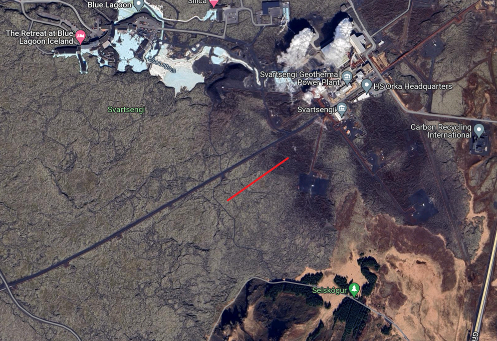
That’s literally on the doorstep of the geothermal power plant. If there really were any increased temperature there, wouldn’t that be detected through increased borehole temperature?
Are there strain meters available somewhere? The strain links on the vedur page are broken.
I also wonder about the tremor you mention. IMO specifically say that no tremor has been detected in the area. In the run-up to the first eruption they did mention tremor that happened during the swarm. Isn’t it just a rapid succession of quakes that make the oroi plot stay high for a while?
It was visible on another feed that I did not use since it is messy as heck graphically speaking.
It just makes me wonder why IMO are not reporting the same thing, since they did report it last time it happened in a very similar way 🤔
What about strain data? Is it available on some obscure page? You didn’t include a plot for that either.
And welcome back! I hope the mantlepower project is making good progress towards saving the world.
Yes Carl, Welcome back! Having been in at the start of volcano Cafe I have been missing your presence. Having being under a different name at the time,
(not many people know that,) due to a problem with Yahoo email after it was hacked, I was unable to comment on here for a long while until I gave up with Yahoo and found a far friendlier email supplier. However I have never forgotten the ‘eat your hat’ saga over Hekla who is still after all these years being a trifle recalcitrent in regards to erupting.
Did you ever BBQ a meat hat? I have often wondered.
However over the years although having very little knowledge of volcanology I have learnt so much from yours, Alberts and many others comments so it nice to hear you also still have a love of Icelandic volcanology. When an eminent Icelandic volcanologist said this impending eruption could be ‘Hours of days away’ I paid attention due to his previous warnings being accurate. I an happy you also agree with the situation. So yes, welcome back for however brief an interval and I shall look forward to your comments,
In regards of the meat hat.
The bet is still open, I stated that I would eat my hat if Katla erupted prior to Hekla.
And that rapidly made both of them go to bed for a prolonged snooze.
🙂 Ah I remember now.. Lost my marbles since the strain of becoming a grandmother twice over. Poonamis are the fault, my daughters name for unexpected eruptions. eruptions
The earthquakes on Kilauea have mostly stopped, its almost earily quiet. But, there are still odd quakes that happen at shallow depth under the Kamakaia Hills. The area has erupted evolved magma so evidently has a storage area somewhere. The current unrest might be over but the connector is now at full length and the next swarm could take off quickly.
Would be quite something to get the first SWRZ eruption on Kilauea in almost 50 years at the same time as the next Reykjanes eruption. And the first magmatic eruption at Iwoto in a millennium…
Fundamentalist Preacher: “It’s the end times!”
Volcano Enthusiast: “Nah man, it’s just a very good week or so.”
I hate week-long DI events, I lose track of the supply variations.
Seems the DI might be over although the quakes havent resumed yet.
Wondering if maybe that little swarm at Mauna Loa last week took away some pressure. Probably not much, but there was a response on its tiltmeter, although very limited so a lot of uncertainty there. It is interesting that it coincides with both the end of swarming at Kilauea (for now anyway) and a rather drawn out DI.
Will be interesting to see the next week if Kilauea comes back strong, magma made it basically to the end of the SWRZ connector so it might take very little to erupt now, but who knows anymore, just about any scenario involving a summit or SWRZ eruption is plausible now.
Yea!!! nice to read…. hope all goes well for the neighbors, tho. it’s not nice living next to a volcano but visiting one is Ewesome. i’ll get the popcorn.
PS… our second Great Grand Baby is several months old now. i thought being a grandmother was great/being a great grand mother is even ‘greater’ 🙂
Pretty sure I’m seeing some Aurora action going on here tonight.
https://www.livefromiceland.is/webcams/svartsengi
Looks like an eruption started on the horizon…
Please correct if I’m wrong
Pretty sure that’s just a city we see in the back (I assume Grindavik)
I am fairly sure that is actually the iceland airport. Sorry forgot it’s name, Whatever it is it is not an eruption as it has been that way for days now,
Keflavik, and you’re right, I just saw a plane land.
Yes. I was fooled by the changing light intensity of the lighthouse(s) that made me think of gas bubbles
This news on Ioto has some footage I hadn’t seen yet:
https://news.tv-asahi.co.jp/news_society/articles/000322894.html
But I think it is a few days old. It’s really difficult to follow the Ioto situation when all the material is in Japanese, and as far as I can tell there are no regular activity updates from whoever is in charge.
Here is another video, shows pumice washing up on some other island.
I wish I understood Japanese.
Morning!
Here is the current quake activity (colors for different days).
Today’s activity (yellow) is so far more to the northeast of Grindavik.
…The situation at Þorbjörn mostly unchanged after the night…
The situation with Þorbjörn is unchanged after the night. Several powerful earthquakes were felt in settlements last night and this morning.
The earth is still shaking on the Reykjanes Peninsula. An earthquake with a magnitude of 3.6 was felt in many settlements at around seven in the morning. Several earthquakes were recorded at Grindavíkurveg last night, the most powerful around midnight.
There is still considerable seismic activity around Grindavík due to the accumulation of magma at the mountain Þorbjörn. Yesterday, an evacuation plan for the town of Grindavík was published, where the townspeople were encouraged to prepare for the town to be evacuated due to earthquakes or eruption.
According to information from the Icelandic Meteorological Office, inflation at Þorbjörn continues at the same speed and there are no clear signs that magma is moving closer to the surface. Experts from IMO say that the situation in the area is largely unchanged after the night.
The Civil Defense has a meeting with IMO today, where the latest data will be reviewed. You can expect an announcement about the latest news as the day progresses.
https://www.ruv.is/frettir/innlent/2023-11-06-stadan-vid-thorbjorn-ad-mestu-obreytt-eftir-nottina-395829?fbclid=IwAR1MZdzclwsdnF7XI0uWkS2DNHGbOSa5A18bpuV1Qt-YKUzK8QAln8AQ6xA_aem_AXxq7uKTCWgkogrYwGaenGyRaWxAf_-HmPSSZUKvX-kMP1p41Z8-So49zHCsjq3DkF4
Inflation keeps going at same rate
And earths interior is stranger than we coud ever imagine, as example LLSVPs in the deep interior of the Earth, maybe the remmains of Theia many many simulations suggests that maybe the truth and was in big science news recently and seems to be more or less accepted fact now. Just like the flaws of the tradiational “food pyramid” we needs also start to see flaws in the general mainstream models of Earths deep interior, thats in reality not that fully understood. Theias materials coud provide some isotope materials seen in some very deep magmas and that was also discussed recently in geology speheres among academics. Theia is tought to be a relativly slow impact, and that explains why not all its parts was vaporised and some coud sink deep into Earths mantle and be stuck in the core boundary in geophysical simulations that was used, so LLSVPs may not at all be any “mantle plumes” but Earths interior is convecting slowly so I ask the question coud the Theia mantle parts avoid being mixed up over billions of years? thats one of the problems with that model, but earths deep interior is poorly understood so the reality down there coud be stranger than we coud ever imagine.´
I can agree that litosphere slabs and even perhaps some ot the more clear examples of mantle plumes are indeed seen on tomography, but most of the Earths interior seems to be just an awful soupy mess
They think the Iceland Hotspot magmas are tapping from the dense Theia LLSVPs, I haves to read these papers as Im not an expert, saying just what I have quick read from news
This is far from accepted science. The LLSVPs and their origin are discussed in (of course) VC:https://www.volcanocafe.org/the-living-earth-rocks-plumes-and-hot-spots-part-ii/. At that time, the proposed origin in Theia seemed unlikely to me. More plausibly it formed from our own mantle, such as from the earliest oceanic crust. By the way, some of the press claimed that the proposed association with Theia was new, but the authors themselves pointed out that it has been discussed before.
Thank you .. I see the Theia parts heat up over time and become mixed in the mantle thats one or the major flaws with that model of LLSVPs with Theia Origin how they must endure 4 billion years of mantle convection
Theias outer parts its mantle was probaly vaporized and vent into Earths mantle and of course forming the Moon and explains the moons very small core it haves today. Its denser parts coud sink into Earths interior by its own density and force, it was probaly a bit ligther than the Earths cores density and Earths mantle even by than may have mostly crystalized so preventing theia from becomming competely mixed in the earlier early hadean magma ocean. The LLSVP origin of Theia Model haves its own questions of legitness, but its pretty possible too ..
Nice to hear from you again, Carl. An excellent article, thanks!
“In regards of the meat hat. The bet is still open…” Who was it on here wanted it to be a Cromwellian Fish Tailed helmet?
Well, that will definitely not happen.
It is a “meat-hat, or go bust” thing for me. 🙂
Hector’s aspirations not withstanding, in this I am reminded of the well worn observation…’Nice place to visit but I wouldn’t want to live there.” The impact of volcanism on the human condition has always been a consideration in these conversation.
I also think there is the potential for minor explosive behavior.
This eruption is at a site with more ground water.
It’s hard to know whether it will erupt to west of Thorbjorn or to the east.
IMO posted another update on the situation at Mt. Þorbjörn a little while ago:
In the last 24 hours around 1300 earthquakes have been detected on the Reykjanes peninsula, of which three earthquakes were above M3. The largest earthquake was M3.6 this morning and located 3 km NE of Mt. Þorbjörn.
Deformation data shows that uplift continues in the area and there are indications on GNSS observations of an increase in inflation rates since 3rd of November. Since the start of the inflation, the uplift at the GNSS station at Mt. Þorbjörn has reached 7 cm. The deformation is caused by a sill-type intrusion at around 5 km depth. Modelling, based on data since 27th of October, indicates that the volume change associated with this inflation event has reached almost two times the volume change associated with the four previous inflation events in the same area between 2020-2022. Inflow of magma/magmatic fluids into the sill-type body is estimated at approximately 7 m3/s which is about four times greater than the highest inflow estimated during previous inflation events here.
While the inflation continues, increased seismicity in the area can be expected from additional stress changes induced within the crust.
See the full text here:
https://en.vedur.is/about-imo/news/a-seismic-swarm-started-north-of-grindavik-last-night
I like the daily updates but this basically says nothing we didn’t already know. The fact that they are looking at potential eruption sites shows that they know there is a decent chance of this intrusion making it
The person who stated that is the well acknowledged master of things GPSy…
The interpretation is correct in regards of center of inflation.
I used quake stack data to calculate the point where it will pop up, the different approaches is giving relatively similar result.
We are a km apart to be exact, and that is just a short distance away from the center of inflation.
The HVO GPS gives directions for movement, which can give information on the source of the deformation. The insar is great but satellite angle can be a factor, maybe not on large scale but for pinpointing the source it is. It looks like the stations in Iceland are very similar although seem to plot less often presumably to give more corrected positions, so it should be possible to find the location and then find where the NS and EW lines cross to give the location of the uplift. If it is a sill then there wont be any exact center of uplift really for the vertical axis but still good to know.
I guess the problem is sills tend to erupt by forming dikes from their edge, not splitting down the middle, so it wont tell us exactly where the eruption will be directly, but at least give a radius.
Updated GPS from article
Data from GNSS station at Mt. Þorbjörn. The graph at the bottom shows the uplift.
And the more the intrusion charges up the more click – baity the …. ” Just Icelandic ” youtube channel becomes, soon its pure market capitalism he is running on his channel, the more the volcano charges up, the more he will really try to capitalise on this intrusion : )
Its kind of fun but also little desciving, but the content overall is good
I personally have found Just Icelandic,s videos to be very interesting. Great to see more of the areas around Iceland as well when no eruptions are imminant. I watch for the sights of Iceland not for clever volcanic explanations as he clearly admits he is no expert on volcanism, Also having lived in Grindavik for a time he has a full insight into how worrying things can be for the Icelanders who could be involved this time.
Iceland is magical and as Nordic Citizen Im basicaly Icelandic Citizen
So I Hopes to move there when I haves more job experience
I wants to be nowherelse now.. and Icelands weather at least around the coasts are very mild, Westman Islands are probaly the warmest winter location in the world at latitude 63 rarely goes below freezing
I hope you get your wish to move there Jesper. I was young when Surtsey first erupted but ever since seeing that magic of an island appearing from the sea I have always been totally fascinated with Iceland. I also will swear that the Icelandic knitwear if the best thingin the world for warmth that I have ever experienced. This year I finally bought my second Icelandic jumper and I will advise everyone who feels the cold to invest in one. I say invest as they are expensive to buy but when you consider they are hand knitted with unspun wool they are the warmest thing I have ever warm on cold winter days and they seem to last forever if treated well.
Typicaly is not cold at all in Iceland during the winter due to the strong marine moderation at the coast
I think the North of Iceland is very cold in the winter for sure. The extremely strong winds bring a massive wind chill do not forget! I am now happy as a pensioner that I live on the South coast of England. We rarely get days where it gets lower than -4C in the winter which is why I can grow beautiful plants in my garden with no winter protection.
https://m.youtube.com/watch?v=zloJ_yptWU0&pp=ygUQZmFudGFzeSBhbWJpZW5jZQ%3D%3D&fbclid=IwAR1qRozFfrUhzDYryfoPEvIdRK7PC2VmFwe1RFWaX-KWw6Fv50lcJlfrEgU_aem_ASH5Zop-mAOhFhd4UDokRPTRaTwK-6PTV6IppSK0ZPg8wbrmrdbmH4oZZGC3QhUGBVg
These soundscape is Iceland in a nutshell.. dark and mysterious and ominous Iceland is otherwordly! Iceland is best looking during an overcast summer day when its green and mysterious and the dark basalt contrast with the green moss in heavy skies and table mountains rise into fog
But its so very dramatic all year around even in winter
To be fair it is basically his job, and the titles arent inaccurate just eyecatching. Hes just a volcano nerd like us but one with an audience, the stuff he says is probably less clickbait than most of the articles on VC… 🙂
Thats correct althrough the logos on each video is baitey as hell
But yes he is a good channel and after all I Loves Iceland so much
Jesper, I think perhaps you have an incorrect idea of what click bait is.
Basically it is pictures and headlines that are NOT correct information and extremely misleading while such videos are full of pictures and events not even from the area they are talking about, plus totally misleading information. I have watched very many of Just Icelandic Videos and have never so far seen one that could be described as click bait and feel it is more than a little unfair to the man to describe them as such..
There is another YouTube channel narrated by a Icelandic-accented fellow that does flip all the gratuitously clickbaity switches. For awhile I was confused about them being two unrelated channels. It was only when I blocked that offending channel that I realized my error, as I continued getting recommendations for Just Icelandic’s excellent videos. Now I check Just Icelandic daily. He really does record some beautiful stuff.
Found it. The offending channel is Dr AstroGeoTech (Hertfordshire Allotment Life) or @TheAstronomer. If you look at the last couple of days video posts from Dr AstroGeoTech, you’ll see the mess he’s creating. He’s even using some of Just Icelandic’s footage. Listening again, I’m not so certain he has an Icelandic accent — perhaps it just sounds that way to my less-than-expert ears.
I found him too, never really took his stuff seriously just watched for the visuals. I thought he had a German accent though, although I guess all of the other Germanic languages have a similar element to them when their accent is applied to English.
Aaa yes thats right you right Alice
Ouch..
Albert, I am always right. 😉 Unless I am wrong. Lol
Feels like back to 2021. The more one starves for news from IMO, the less information is announced. And again, I find myself craving for maybe only a single new sentence, a few words about the magma, about the gases, about what its all about, but no, they want us to endure their cold nordic patience…
Well put.
We can speculate freely. IMO cannot!
( Remember the sunny La Palma? The sweetness of the charts, the ever flowing information? The happiness the colorful Información sísmica brought us? )
I agree with you Albert, for sure no one will quote me but if you are a member of any organisation one must be careful what one says.
And Quinauberon, I do indeed remember but I also remember very many restrictions on ordinary citizens wishing to view the eruption, there is a saying, swings and roundabouts. some prefer swings and some prefer roundabouts, I love both.
,
I am also a very opinionated whatsit at times so my husband says. I just laugh! Getting uptight about things one cannot change is the territory of the young.
This graph GPS Skipastighraun is fitting as addition to the article well.
Skipastighraun is a bit to the west of Thorbjörn (and west of the centre of the inflation as well I think. Therefor is it moving Northwest).
In the start of the graph you can recognize the (triple) inflation of 2020 and further inflation periods easily.
I remember that during the inflation of 2020 some caves in the area were closed because of sulfur gas emission (!?!?!). Can’t remember the details.
I sort of had to limit myself a bit on the graphics since the article was short.
But, I used all of the surrounding GPS-plots when I reasoned with myself about publishing the article.
Sometimes I ponder if Articles like this is really the best format to publish these things at.
I have upon occation pondered making these “It’s gonna erupt notifications” in video format due to the ability to go through more source data.
But, then I would need to grow a third arm and a few more hours per day…
Articles are just fine. Good format. But the blog…. ehhhh. (Better you do not see my face in a vid know).
Non or bad english speakers can read carefully and translate.. . 😮🙂
Thanks Carl!
It was CO2 collecting in depressions around Eldvörp. Not a good thing since exploring lava tubes is a popular thing around there. That happend a few weeks after the first uplift started.
Yes, I remember know. 👍
Answers…
I will try to check and answer questions once per day, but my other real-life obligations must take precedence this week, as they have had to do for more than a year.
It is after all a bothersome world out there beyond our little cosy volcanic living room.
And no, I can’t for “reasons” say what I have been up to, and am up to, and that will remain a fact for the next 75 years or so. So please, do not ask, and do not speculate please.
Just know that my contract ends on Friday at 1500 hours local time, and that after that I will be more active again.
i want to speculate : Carl on a sail boat….. with Wifey …. sailing anywhere he wants. ( the snow has come again; please don’t take my fantasies away.) Best!mots
Winter was created to make us appreciate summer. Hope you family is coming for christmas! And perhaps we will have a nice warm Christmas eruption for mid-winter cheer?
Not that cold in Malmö in winter.. but its dreary as hell with wind and rain and gloomy skies and awful wet cold. The bright white winters further north are much more fun than where Carl is stuck at current
Given the increased seismic activity near the Blue Lagoon – has evacuation begun yet? What about Grindavik?
as far as I know the answer to your question in a resounding No as to the Blue Lagoon. Plans have been made for evacuation at Grindavik once an eruption starts.
https://www.youtube.com/watch?v=0sZzBotLUU4
check the above webcam. Lights still blazing at the blue Lagoon so no evacuation yet.
The NORTHERN lights are blazing from that camera at this very moment.
According to its website, the Blue Lagoon is still open. It may still be taking bookings (I did not test far enough to see if I could actually place a booking). At the time of writing it has changed its cancellation policy; you can now get your money back if you give more than 24 hours notice. There is also a banner on the top of the site advising of increased seismic activity.
The big question is whether or not Þorbjörn will be so kind as to give more than 24 hours notice …. and whether or not staff would stay there to process the cancellations (I wouldn’t).
Very early to say yet but could the thickening of the line on this drumplot possibly the start of harmonic tremor? It certainly looks interesting, however as I dont know the situation of this seismograph it could of course be human interference although havent noticed it before. Does anyone with knowledgehave a view on this.

Of courese, as always, time will tell.
I’m not sure, but it looks like steam:
https://ibb.co/SfKJ4Rm
Of the page:
Sorry, I was too hasty…
I just rewound and saw that there must be a drop of water on the camera…
I should have done this before, sorry again…
It’s a water drop on the camera. If you go back to day time you can see similar drops.
Is this normal in the lower right of this camera?
https://www.livefromiceland.is/webcams/svartsengi
And something going on the left side of this camera… Although not use to looking at this cam at night
https://www.livefromiceland.is/webcams/fagradalsfjall
I am assuming that what you are refering to is the lights from the geothermal plant.
seen on both cams
Please find below one of the more interesting efforts in autotranslating Icelandic:
Mercury deposit and herring
Móberg Mountain .orbjörn has risen by 7 centimeters in recent days due to constant landslides that occur at high speed. The center of the ridge is under the northwest corner of the mountain.
Mercury infusion at about 4 km depth is thought to cause the landslide. Unlike the repeated deposits in Fagradalsfjall in recent years, where vertical mercury shoots through the earth’s crust, it is believed that a so-called “herring” is forming under Thorbirn.
Silla (also known as lagging) is simply a horizontal deposit that penetrates into the earth’s crust and lifts the land above it. The mercury that feeds the inlet comes from a mercury storage or compartment that rests deeper in the earth’s crust, even down on the borders of the earth’s rust and moth. So far there are conditions in the crust under Ennorbirn so that it is easier for the mercury to spread horizontally in the form of herring rather than looking upwards in the form of a vertical mercury.
It is estimated that about 7 cubic meters per herring flows up every second. The herring is increasingly valid in addition to the fact that it spreads horizontally, but each of them pushes landris on the surface. The longer that process goes on, the chances that mercury will shoot itself out of the herring increases, which could lead to volcanic eruption. Such a quick walk does not necessarily have to be shot out of the middle of the landslide, but can be recorded on the edge of the herring and search beyond the landslide itself. This happened e.g. 2010, when a kite ran out of herring under the middle of Eyjafjall Glacier and appeared on Fimmvörðuháls.
When you are in a kite and run out of herring you have to resort to sea biscuit.Here are the latest quakes, colored according to depth.
To add my red mercury herring to the lagging chair (silla) (almost a sofa, Clive), here is my best guess at where the magma is trying to break through, baed on the shallowing of the earthquakes.
The name of the volcano will be Kvikasilfurssíld then! 😉
Blaa Lonidshraun, me thinks. An eruption there would most likely spread northwest at first, although altitude levels are very small so it could go in other directions. Grindavik would be safe though, unless it follows the rod over a 10-meter high ridge. If lava flows around to the west, there is a way to the southern coast but in an unpopulated area next to Grindavik. Past hrauns in this location haven’t spread very far though. If an eruption occurs south of Thorbjorn, then Grendavik will need evacuating. But reading the earthquake plots, this seems to have lower probability. Of course everything could still calm down without an eruption!
No way. Kvikasilfurssíld is almost pronounceable.
Does it have to do with this? Cannot interpret the map:
https://www.visitreykjanes.is/en/place/eldvorp
Also interesting: In the evening, mbl.is reported that a drone pilot had detected heat fields along the Illahraun during an overflight with a thermometer. The volcanologist Þorvaldur Þórðarsson described the discovery as remarkable, which should definitely be investigated more closely if there are daily changes.
Passage from:
https://www.icelandreview.com/de/natur-und-reisen-de/reykjanes-eldvoerp-als-moeglicher-eruptionsort-rueckt-in-den-fokus/
translated by DEEPL
Eldvorp is further west, associated with a small lava field. From the colour, it may date to the last cycle 1000 years ago I think. Yes, that is the kind of lava field I think might form. Depending on where (if) it happens, this could be bad news for the blue lagoon – on the other hand they would have all the thermal power they need for the next decades. Otherwise it would be a tourist eruption
But earthquake activity has moved away from Eldvorp again and the inflation was never there, so I do not expect it to erupt there.. Also, eruptions here are independent of previous activity and have no affinity to past eruption sites. There is no reason to expect they would be at the location of an older cone.
Do you think magma is rising? The shallowing earthquakes have made me worried, but the IMO scientists say there are “no clear signs of magma rising”. The “clear” might be key here. That there are signs, but they’re not sure yet.
It seems most people here on the other hand seems to think that magma is already on the rise. I don’t know what to think 😛
The earthquake activity had shallowed a bit to 4km, but only in this area. The rock is responding to the magma, but that can also happen without the magma rising up. This area is also complicated because of the pumping of deep water that is going on. I is advisable to allow for the option of opinions to change!
I’m convinced magma is not rising yet. Earthquakes are from rock cracking, not magma moving.
Above the intrusion, rock is deforming elastically until the strain gets to high and it cracks in an earthquake. This affects a wide area, and the places that are already under great strain from the tectonic plates separating is where we see the most quake activity.
If magma starts to break way towards the surface, there will be an intense smattering of small quakes with gradually reducing depth. That is not yet seen. The depth distribution is the same now as it has been from the beginning of this episode.
Interestingly Albert a new webcam has been set up really close to that area.
http://www.youtube.com/watch?v=P1e_MWJ1nQc
Cam by mbl.is
I took a walk over Þorbjörn and on to Svartsengi whilst waiting for last year’s eruption. The area you have ringed is ca. 10-15 metres lower than the nearest bit of N-S road and the col a bit to the S is higher still. Much of the rest of the road down to Grindavik is somewhat elevated, too. There are hot water pipes into Grindavik beside the road.
However, whilst it seems pretty obvious that Svatsengi and Bláa Lónið are immediately threatened (with explosive consequences, too), where the lava would flow from there is – equally obviously – much harder to predict.
And since most of the area surrounding Grindavik (and Svartsengi) is lava field, it’d be a lot harder to build dams, I’d have thought, than it was near Fagradalsfjall.
Correction: last July’s eruption
what depth are you estimating? Last time I heard magma was shallowest at 4km?
Albert, that spot looks exactly where the live in Iceland webcam is set up (or at least where I think it is from the view)
Would make for some good footage!
Albert, how can we scientifically tell when a sill at 5 km depth is now starting to create vertical dikes to the surface? Can we accurately guage when they are close to the surface?
The terms used are rather odd. It would make for a good April Fools article
Thanks for the laugh!
That reminds me of the “sofas” off the coast of El Hierro a few years back. (Flooating pumice.)
kvika = magma
kvikasilfur = mercury
🙂
Now that kvikasilfur fascinates me Hilda. English has some Old Norse words mixed in with many other old languages that came to these Islands. At school we were told another name for mercury was quicksilver. I finally see the connection. I always thought it was called quicksilver from the way liquid mercury runs so fast and probably it also was for that reason
Sorry for the wrong spelling of your name!
No worries. And I think you are right, it’s called quick silver because of how it moves, fits with the Icelandic definition of the adjective kvik(ur) which means “lively”, “active”, “constantly moving”. The same goes for magma, it keeps moving too.
In German mercury is called Quecksilber, even though “queck” is no longer a word for us. Quicksilver is literally quick, liquid, silver, There’s also Quacksalber, a fraudulent doctor, those who used to sell salves containing mercury. And in Icelandic quick has morphed into the word for lava!
Hope you don’t mind an off-topic post, amused by the mercurial herring, waiting and not having anything to say except hoping it doesn’t erupt under the power plant or lagoon.
Is that where we get the term Quack in English for a dodgy doctor? Love how languages are related.
Nothing much happening at the moment that is ON topic so I find your post hurax very interesting indeed. Thankk you very much for the interesting input. If others have different views then sorry, however to my knowledge Volcano cafe was built upor on topic as well as off topic posts. They say you learn something every day and you have taught me something today so many thanks.
Now on topic again… I also share your hopes, as I am sure do many in Iceland, that the blue lagoon will be spared, however, mostly I wish for peoples home in Grindavik to be spared. To any Icelanders reading this, please be assured that while we all want an interesting eruption, the vast majority of us would be very sad indeed to see kindhearted Icelanders being displaced from their homes.
@Eolienne: Indeed, the quack is related.
https://www.etymonline.com/search?q=quack
I always thought mercury was called quicksilver because it is a metal with a shiny surface but also a liquid, and which is both heavy and has a very low viscosity, so flows very fast. As in, literally like silver water. But seeing that the other Germanic languages, even older ones, seem to have a variant on the name maybe means it was the original use of the word. But, trade was also widespread too, the word might be a loanword, and Iceland doesnt have any natural mercury minerals or otherwise so they might not have a native word.
The real thing that is weird is why in English it is called Mercury, I presume named after the planet or something to do with it in astrology, as most metals of antiquity were. In French and Spanish the element Hg is called Mercure and Mercurio respectively (at least what I could find online) so the name seems to come from the Latin half of English. Although the actual original Latin name for the element was Hydrargyrum, where the symbol comes from, and that came from the Greek name Hydrargyros, which means ‘water silver’… So the names in Spanish and French could actually come from English, or dont refer to the element and only to the planet, or just mean nothing. Hector can confirm that though I expect 🙂
It is such a shame that Hg compounds are so toxic, it is one of my favorite elements, liquid metal that outside of the above issue is actually safe to touch. With a glove it probably would actually be completely safe although best avoided.
It is far more of a shame though that while mercury is treated like a chemical weapon, lead is almost considered benign, their chemistry is very similar in all of the ways that matter.
Mercurius was the Roman name for the god Hermes, so must have come from there. Not that I know much about it though.
Hermes is a package delivery company here. Their performance is best described as ‘mercurial’
I still remember at school heating mercury oxide until it turned into pure liquid mercury. I always wondered what the science teacher used it for afterwards. i still remember hispanic when someone broke their test tube and it ran everwhere in little globules.
Realistically, the oxide was probably way more hazardous than the metal. Fine powder that dissolves in acid… Hg metal doesnt really react with anything you are made of, it us almost as inert as actual silver. It does oxidize in your lungs though, lots of oxygen and it is wet and maybe slightly acidic with all the CO2.
I remember holding a plastic bottle of mercury. It felt like throwing around a lead weight but it moved around like a water bottle, its hard to describe how it feels to hold a liquid that is so dense, you really cant fake it.
Image link didn’t work. Here is the link to the site: https://www.reddit.com/r/etymologymaps/comments/skferi/etymology_of_mercury_metal_in_european_and_other/
ahh quicksilver ….
The intrusion keeps going on same speeds and is pretty unchanged so far so I see it can erupt If it keeps going, the inflow rate is 7m3 a second so about the same as some faster lava shields eruption rates, If this is the supply from the deep mantle during the rifting fires it coud be significiant
7m3 per *herring* please.
Let’s keep the units consistent.
Kilauea seems quiet but there is still a cluster of quakes going on down on the SWRZ, it is still ongoing now, with a quake at about 1.5 km depth in the last 2 hours. The tilt is climbing rapidly out of the last DI event so this could get interesting.
Ok so the DI event is definitely over… in fact the tilt has gone up so much and so fast that all of the tilt levelling this month has been recovered too.
Very interesting that the SWRZ is still quiet, maybe that is too early to say yet though.
Nearly 20 days of a DI event complex… This was a long one. I’m curious whether the SWRZ will reactivate, it seems to be taking its time.
HVO actually did make a map on the 7th that I missed. They mentioned that by the point the rift went quiet much of the new seismicity was under the Kamakaia hills, which still get some small quakes even now. Seems like the magma has got past the fault zone, which is probably at least partly responsible for the quaking, down at the Hills it is only spreading, further up there is probably some sliding blocks.
https://www.usgs.gov/maps/november-5-2023-summary-map-intrusive-activity-kilauea-volcano
I used to think it was part of the plumbing but at some point I started having doubts whether that cluster downrift of the Kamakaia Hills is actually “dry”. A system of faults starts there that connects with the surface expression of Kilauea’s decollement/detachment/thrust offshore. It is an area that makes a lot of quakes after dike intrusions as if the pressure from the dike affects that location, but it is not very well coordinated with the swarms of the connectors. For example the SWRZ connector shut off during this long DI event, fitting the long-estabished tendency of the connectors to swarm during times of summit inflation and be switched off immediately by DI events due to the reduction in pressure. The downrift of Kamakaia cluster, however has not stopped during the DI event, which does suggest it is not as directly related to the plumbing as the connectors. I’m not sure if I had any other reasons to rule out that particular earthquake cluster as dry, but I do think of it now as more of a tectonic thing that is of course related to the volcano but not directly.
Seems plausible. My interpretation was that the gap between the connector and this swarm area was where the magma that fed the evolved eruptions in the early 19th century was. The connectors seem to be fairly narrow whatever form they are, but evidently given the size of pit craters on the ERZ some parts of the rift system is much wider. This area does correspond to the point just downrift of where the connector meets the Kulanaokuaiki fault, and there is a bend in the rift. The same spot on the ERZ has spawned Makaopuhi and Napau, as well as most of the lava shields. On the ERZ this magma can drain away, I guess it cant on the SWRZ as no pit craters exist there, at least it hasnt done this in the past few millennia. But even being less active it would be expected that similar situations would result in similar formations.
I guess we will need to wait and see, some answers may not take long to find.
“I guess we will need to wait and see”
I did think we were going to see,but why does the SWRZ all of a sudden seem dead? With the ongoing jump out of the DI event complex the summit has already exceeded its previous inflation high by 4 microradians and rapidly going up. There is not the slightest sign of a resumption of activity in the SWRZ though. I may be a bit impatient, but I do remember that in 2019, with the summit-ERZ inflation and earthquakes, when the ERZ connector went silent during DI events it would come back to life as soon as the tilt reached the previous pressure high during the reinflation out of the DI, and reached its maximum seismic activity during the end of the I phase as the tilt jumped above its previous high value.
The ERZ and SWRZ connectors might not be completely identical, so have different levels of reactivity towards the summit. The ERZ has been completely dead for two years now until possibly (emphasis on possibly) this past few weeks. And the same time it dies tge SWRZ becomes much stronger. It seems like at tge very least they are not really completely compatible, strength in one correlates to weakness or obstruction in the other. The biggest obstruction is that the SWRZ doesnt go to the ocean usually so if the ERZ is open lower than about 750 meters then it has gravity on its side. The only successful historic eruption of the SWRZ connector was after a long ERZ eruption failed and magma couldbt go down that ruft further immediately.
The SWRZ connector may connect at a deeper point than the ERZ, so being more affected by pressure but also being lower means if it is open it can cut supply to the ERZ. It also doesnt look nearly so pinched by spreading as the ERZ does, only lower down.
5 microradians up at Uwekahuna and continuing, still no sign of SWRZ reactivation. Things might be going back to the summit. I think Kilauea can still make the 4th Halema’uma’u eruption of 2023 in time before the year is over.
The SWRZ inflation-earthquake episode that we’ve had since late August could be the precursor to something in the future or maybe the deep rift opening of the SWRZ might allow Halema’uma’u to open more now since they are tightly related. Maybe it does resume and we do get a dike/eruption this year but I’m starting to see the possibility that in turns back to the summit and does another outbreak there.
By the way, this is no longer the jump out of a DI event, it’s a really large surge in supply. Maybe it’s the deep long-period swarm under Mauna Loa of some days ago showing up at Kilauea.
A couple of days old, but it has also reached Norwegian state broadcaster NRK.
Can for sure be put into Google Translate for those not reading the language, copy/paste the whole link and chose your language:
https://www.nrk.no/urix/island-pa-kanten-av-vulkanutbrudd-1.16624765
the drumplot looks to be getting interesting too. Surely it cannot be long to wait now.
Chad, do you think any eruption down there could start the draining of the summit lake again or is this likely to be entirely disconnected?
It isnt really certain, but the lava lake at the summit now isnt connected to the magma chamber like the one in 2018. This is like the crater floor of Kilauea Iki, which was a similar lake formed in 1959, only the current one is way bigger and deeper.
The location of that little swarm of quakes is at the Kamakaia Hills, which are about the same elevation as Pu’u O’o, its not low enough to induce a caldera collapse and it isnt clear if an eruption like 2018 is actually possible from the SWRZ. If an eruption does break out down on the rift it will induce strong deflation on the instruments but not physically collapse anything. If it simultaneously opens a fissure in Halemaumau too then there could be a hydraulic connection but I am not aware of any case of Kilauea opening a summit and rift vent at the same time at the start so that would be very surprising.
Many thanks for the reply and explanation Chad.
Biggest rootless lava lake on the planet now.. a very Impressive thing and is now a shallow magma chamber thats not connected to anything. Woud be fun If it can keep filling so it gets even more impressive
Also the biggest lake of any sort with the Pacific ocean. Although, Taal and Taupo are possibly counted, so its a nebulous title. But the Halemaumau lava lake is absolutely the biggest standing body of liquid on the surface within Hawaii, it has that going at least.
With the new data for the last eruption, the total volume is now sitting at about 202 million m3 of lava, or 0.2 km3. So that is about 40 million a year averaged since 2018, compared to the likely 0.5-0.9 km3 of magma that has been fed to the volcano in that time. Even the lowest end of that has only 10% of magma fed actually erupting, the rest is filling in the 2018 damage underground this is much the same as happened in 1975 too after the earthquake.
So basically Kilauea now is only showing about 1/10 of its potential. When the damage is healed things could get pretty wild.
🙂
I wonder how deep the man made geothermal system is under the geothermal plant
If you click on Svartsengi Geothermal Plant in GoogleMaps, there’s a review from when you could tour the plant and someone has left some info:
“The plant is the first in the world to combine electric and hot water production from a clean and renewable source.
Geothermal brine, heated by magma up to 240C is extracted through 17 boreholes drilled as deep as 1.85 km.”
How accurate that is I have no idea!
You can use the National Energy Authority data base to locate and find data on every well in Iceland. They even have a map overlay online here: https://map.is/os/
Chances of an eruption at Fagra again instead of here?
Is Fagradalsfjall still inflating?
It’s not entirely easy to say. The GPS movements from the deep inflation are much slower, so at the moment they are drowned in the inflation from Thorbjörn. Also, there’s so much noise in the GPS measurements so you need more samples. At the moment the up component for spectator hill (GONH) looks like it has stalled, but it’s still within the variation that could be caused by noise.
There are two new GPS stations. One that has been there for a few weeks now, right at Keilir (KEIC), and one that seems to have been installed exactly when the current episode started, Kast (KAST). Looks like it’s placed on a western outcrop of Fagradalsfjall towards Thorbjörn. These will make it easier to track deformations from Fagradalsfjall once the current action slows down.
Please be aware that first-time comments are quarantined by our demon. Sadly this is for good reason! The comment then has to wait for an admin to take a look in the dungeon and release the comment, which can take anywhere from an hour to a day. After that has happened, future comments on the same account normally appear instantly. I will delete your other dungeoned comments. You can resubmit if you want!
Jesper, in Iceland they are discussing it – that’s all I know.
So, you preferred Boulevardier, obviously. My favorite cocktail was and will be Moscow Mule, but it’s not a good choice at the moment as ndp
Thanks.
Volcanic activity proably jumps between volcanic systems during a reykjanes fire
Feel free to adopt another moniker! It shouldn’t get you back in the dungeon. Changing (or mistyping) the registered email is frowned upon by by the demon, changing name is not. I think.. but a Moscow-oriented depiction might raise eyebrows otherwise by some.
I am quite happy with the name change, thing’s “Moo’s-Cow” is having a bad ring in my ears in this part of humanities history.
That being said, a Kyiv Mule is very tasty indeed (formerly known as…)
That is possible – it happened in 2021. But that will require an other intrusion in that area. The two are not directly connected magma-wise but stress can transfer from one area to the next. If this intrusion fails to erupt, then Fagradalsfjall may well be next in line.
If what’s in the article I posted below is true, and the same thing is happening now, then there’s a direct connection and the upcoming eruption will happen at Fagradalsfjall in a few weeks or months and not at Svartsengi in a few days or weeks.
One thing I would really like to know is Carl’s opinion on this theory: (there is a newer publication, but that one is paywalled)
https://www.researchgate.net/publication/353497351_One_year_of_cyclic_unrest_in_a_hydrothermal_field_as_a_harbinger_of_a_volcanic_eruption
Exerpt from the abstract:
“The resulting model explains the geodetic, gravity, and seismic data by magmatic derived gas intruded into a horizontal sealed aquifer at 4 km depth in the roots of the geothermal field at the top of up-doming brittle-ductile boundary. The total injected volume is estimated 9.5·107m3 with optimal density of 840 kg/m3. Our results suggest upward migration of three packages of volcanic gas along the brittle-ductile boundary from a subcrustal magmatic source 8–10 km east of the geothermal field, with important implications for the dynamics leading to the eruption.”
The topic seems right up Carl’s alley and the paper is very well written. The fact that CO2 was detected in depressions near Eldvörp a few weeks after the first uplift episode seems like more than just a coincidence.
“a horizontal sealed aquifer at 4 km depth” – What happens when magma meets water at that depth? Presumably bigger EQs…
Depends on whether or not the constraining pressure is enough to prevent water from flashing to steam. I don’t know the answer to that one.
If I get a few minutes over this night or tomorrow I will give it a read.
I am a tad occupied right now…
Real life getting in the way of volcanic fun 🙁
What’s the weather doing near Thorbjorn & Fagradalsfjall? The drum plots are picking up a bit.
There hasn’t been any large quakes in a while, so I think the autoscaling of the drumplots has changed to make smaller signals stand out more.
Thank you.
Actually, looking at the lowpass plots it does look like weather. It’s equally strong along the entire coast, so it’s not tremor. That would show up stronger close to the source.
So if the magma supply to the area is 7 m3/s (presumably separate to that of Fagradalsfjall, which is similar or even a bit higher), then the current intrusion has formed in about 1 million seconds, or about 11 days, which seems pretty consistent.
The big unknown is how open the path is up to that 4-5 km depth, it seems it is rather mature if it has done intrusions now 5 times in the last 3-4 years. The current intrusion might not erupt for a while yet but if that supply is sustained for a few months the volume of that sill is going to be significant, combined with the prior intrusions it could be over 100 million m3 by the end of the year, and very likely larger than any of the intrisions preceding the Fagradalsfjall eruptions.
This would be very bad news for Grindavik, an eruption now would probably still be intense but volumetrically small, and unlikely to flow towards the town or even reach anything depending on location. But 100 million m3 would open a long fissure and cover a wide area very fast, or if it does stay restricted to a short fissure then that thing is going to be like a geyser from hell and make little difference really. I have always wondered if the name of the nearby Eldvörp craters is literal, there are many vents that would have been seen in that time and many lava fountains, not to mention all the other eruptions with huge fountains seen in the past millennium (Laki and Hekla come to mind). But this particular line of craters is the one that was was given the name ‘flamethrower’… Seems that for all the relative lack of volume the eruptions here really go big or go home, no little spatter cones until it is dying out, the eruptions probably last a few days at most with huge fountains going hundreds of meters high, maybe even taller, the groundwater probably has a bit of an effect. And 100 million m3 is equivalent to a VEI 4, that is a huge amount of lava to erupt so fast.
The same idea also came to my mind. If it would erupt now, it would probably be a small (or medium sized) eruption. Of course a potential destruction of roads or the powerplant would be bad news, but we are still speaking of limited material damage.
If the eruption fails (and for the moment it could be a very realistic scenario), magma will continue to accumulate. Frequent earthquake swarms will follow… and one day it will unzip and cause damage on a much wider scale.
I doubt that the influx of 7 m3/s will continue for a long time, though. If the magma continues to hit hard ground and pressure builds up, it’ll reduce the rate of influx, right?
I’m still confused regarding the magma source. Is it really separate from Fagradallsfjall? Is it derived from MORB? Or is there also a tiny connection to the hot spot as proposed for Fagradallsfjall (which would mean that there is a common supply). Probably only the chemical analysis of the lava will provide a definite answer to those questions.
Some sill intrusions may keep going for years years slowly and later stop.. these are failed lava shields I often imagine for myself, the rate is driven by the magma supply .. if it hits a hard object it will be diverted elsewhere to weaker sourroundings or push to breaking point
I also guess that cO2 gas are the one of major drivers now that push it upwards togther with the background supply. cO2 been detected as well in the area. Its the sulfur and water vapour thats the real rocket fuel and those bubble out much more shallowly and the intrusion becomes like a runaway nuke and erupts through that IF it can get shallower as the pressure keeps pushing
The high magma flux is likely to be strong, it is pretty persistent for Fagradalsfjall, and it is indeed possible the two are connected deeper down although until an eruption takes place at Svartsengi (or somewhere else) it is impossible to be certain about this with only 1 sample location.
The supply will only slow if pressure builds, which is not really good either. I remember seeing something for Kilauea that its supply into Halemaumau is much lower between eruptions because there isnt an outlet, but the pressure grows significantly, hence the intense start. Magma is like hydraulic fluid, to extend the piston makes little pressure and the pump pushes a lot of fluid, but when it has to push something the fluid has a lower flow rate but creares a huge pressure.
If the sill can keep expanding then the eventual eruption might be pretty big but not that intense past the very start. If it stalls but magma is still trying to get in then pressure will build and a much more powerful eruption could result even if less voluminous. If the sill grows large then hits a limit then both of those things could occur…
At least that is what I understand. It is complicated. But the fact most eruptions in the active area now are long fissures with simple sheet flows surrounding would tend to imply magma is building up in the crust and then bursting up all at once instead of continuously like in 2021.
Will look like Wolf 2015 If it erupts just that its on flat ground, yes very fast well over 1000 cubic meters a second is maybe possible, lava fountains dense and fast will heat their own clasts so everything flows away leaving hardly any spatter / cinder heaps.. not unlike Mauna Loas caldera eruptions. Will be a terrfying flood of sheet pahoehoe and thin Aa and the svartsengi flows have Mauna of the features of Mauna Loas caldera with drained sheets and thin sheets flows
Perhaps will be a slow eruption too, fast fissure eruptions like Krafla and Mauna Loa and Hekla are caused by fast moving intrusions, this one seems perhaps slow. But at 4 km down its deep enough so the magmatic gas cannot bubble out and drive it even faster, gas nucleation is a major driver of an eruption rather than that magma supply itself… most eruptions are gas geysers as that magmas gas bubble nucleate and drives it upwards, so a slow intrusion can become superfast ones the gases starts to bubble out most, almost all eruptions are driven by overpressure
But eruptions here in Svartsengi tends to be short and fast but its Impossible to know what will happen, the sooner it erupts the smaller it may become.
Its in a rifting episode so the mantle is melting deep down at increased influx so I see No mean that this will stop anytime soon and 7m3 is pretty significant and coud be very significant if the plume materials are involved thats probaly will be even more melting
Will be very fun to see If fagradalsfjall is still inflating, and since plume materials are present it coud be that the magma from the hotspot is perhaps flows in Icelands rift zones lateraly like in Kilaueas connectors, that woud not be suprising at all
This may be worth what you paid for it, but this lady seems to imply that the hotel operators aren’t telling their guests what’s going on–sorta like a modern-day St. Pierre:
https://www.instagram.com/p/CzUfK99NSul/
Oh God, the number of comments comparing the situation in Iceland to Whakaari…
*Facepalm*
https://en.wikipedia.org/wiki/Maar Could also be much worse Whakaari if groundwater gets involved.
just found this very interesting article in an Icelandic magazine. Pleased someone is taking responsibility for tourists who may not know thw situation.
Suspend Blue Lagoon Transport Due to Threat of Eruption
http://www.icelandreview.com/nature-travel/suspend-blue-lagoon-transport-due-to-threat-of-eruption/
The comment ‘but so far there have been no signs of volcanic unrest’ seems to refer to actual tremor? Funnily on the blue lagoon website the suspension is justified with ‘seismic activity suggests volcanic unrest in the area’.
It’s o.k. we are not nitpickers.
Yes, this was a comment of Alice’s post. Missed the right button for the 67563th time.
…Increase danger level at power plant area and start building defensive dikes now…
Ármann Höskuldsson, Prof. Geology says that the government should immediately give the green light to the construction of dikes due to a possible volcanic eruption.
https://twitter.com/Icevolcanx/status/1722270380436656257
We’re gonna build the wall and make Keflavik pay for it
Another update from IMO on Thorbjörn.
“”Updated 8. November at 2:40pm
Approximately 1200 earthquakes have been measured in the last 24 hours, most of them in the area between Þorbjörn and Sýlingafell, similar to the day before. The largest earthquake was M3.4 at 12:31am last night, just south of Þorbjörn. The seismic activity continues at the same depth as before. It is likely that seismic activity will continue, and be episodic in intensity, while magma accumulation is ongoing.
Uplift continues at a similar rate as before according to Satellite and GNSS data. Interferogram (InSAR) for the period 28th of October – 6th of November showing near-vertical motion confirms this, but it also shows offsets due to fault movements associated with the seismic activity. Updated models based on the same data estimate that magma continues to accumulate in a horizontal sill at a depth of about 5 km and since the beginning of the inflation event (October 27th) the average inflow is estimated about 5 m3/s (uncertainty is ±2 m3/s)””
Interferogram (InSAR) for the period 28th of October – 6th of November shows that deformation in that period is around 7 cm. SW of Mt. Þorbjörn is an offset in the deformation signal caused by fault movements by earthquakes.
The uplift area seems somewhat larger now. The uplift centre has moved a bit the west since last published interferogram. Copied from IMO frettir page.
It’s an illusion since it shows ground motion relative to the satellite. That includes horizontal movement. The inflation center remains in the same location.
Note that it looks like someone took a bite from the bottom part. That’s the displacement caused by the largest quake in this episode (M4.5). On the western side of the quake, motion was towards the satellite, so that part looks like it uplifted more. In reality that was a horizontal movement. On the eastern side of the fault, red has turned to green because the ground motion is away from the satellite. The quakes between Þorbjörn and Sýlingafell are also visible and have turned some yellow into green for the same reason.
I do not agree this time with you Tomas. 🙂
There are slight changes in the movement of gps Svartsengi and Eldvörp that show that the uplifting area is larger than the it was last week of october.
Perhaps evidence is small, but does count to my thought.
Skipastigshrraun stopped going north and Eldvörp has started to move south for several days now. Meantime uplift still is ongoing at those stations. I think the centre of the uplift has moved.
I thought so too at first, but look at SENG in the 8-hour plot (https://strokkur.raunvis.hi.is/gps/8h). At a quick glance it looks like it’s been generally moving west and then suddenly turned east, but look closer. Consecutive samples trend east all the time, but then the earthquakes cause several jumps to the west. The general slope in individual segments never change and have been to the east all the time.
The same is true for the north component of SKSH. It hasn’t been moving much due to the uplift, but has moved north in discrete steps due to earthquakes
The affected area has increased, but I think the center of uplift remains pretty much the same. Horizontal movements reflect both uplift and quake activity, while the up component shows mainly the uplift. This is because earthquakes in this area are predominantly strike-slip and don’t have an up/down component.
Forget to link it proper.
https://en.vedur.is/about-imo/news/a-seismic-swarm-started-north-of-grindavik-last-night
Hello,
Do you know where we can find the daily updated plot of GPS measurements for THOB station, if it exists?
Thanks, by the way, for all these interesting articles and disucssions. I do not comment them regularly, bu I do follow the discussions!
Regards,
Marc
The 90-day plots for THOB can be found here, don’t know how stable this link is:

Nice, thanks!
You can find all of them here on one page with a map that shows where each is located.
http://brunnur.vedur.is/gps/reykjanes.html
To me this alleged eruption now seems like a lot of smoke, but no fire.
I don’t know what’s going on at the IGEPN, but their handling of the current swarm Chiles-Cerro negro is an damned embarrassment. For almost 2 months, they’ve released no reports concerning the current swarm. No special reports, no daily reports, no weekly reports, no monthly reports, the seismograms are down, the gps data is no longer available. There was a M4.8 alongside 25,000 other earthquakes in October and they just barely acknowledged it. They did publish some reports in late September and early October but they’re no longer accessible.
So let’s just get this straight, there’s been 3 major warms in a little over a year and a half, and at the same time, the IGEPN slowly stops reporting on the volcano as the volcano becomes more unstable? What??? Am I missing something? As the 2022 swarm started they stopped the monthly reports and it’s only gotten worst. Keep in mind, that they’re still delivering regular reports on other volcanoes it’s just for CCN, There is only two options, the IGEPN is either GROSSLY incompetent or they’re being deliberately malicious. Pick your poison.
You can see the Aurora on the “Live from Iceland” Svartsengi cam. 19:06 local time.
Mac
Came here to say the same! Saw them last night too. Hopefully will see them live in the flesh one day.
The Selvogur view is quite good too right now.
https://twitter.com/Icevolcanx/status/1722344791134916653
6-8 m high, 4 km long, 2.5-3 billion ISK: This is how the defensive dikes would be
And what would happen should the eruption happen inside the defensive dyke?
I think the objective is to protect the power plant and Grindavik direction…
Oh I am sure that is the objective, However absolutely no-one at all. no scientist, no layman, even no idiot can possibly predict where this eruption will start. A defensive wall could be a death sentence surely?
Perhaps I was taught to ‘think outside the box’ too well.
For a moment I misread that as 6-8km high. Nearly coughed out my coffee. Now that would be an accomplishment…
When I was a child, I read the book “Hill of Fire” by Thomas P. Lewis. For a couple of years after I read it, I was pretty sure that volcanoes are attracted to corn fields. I remember looking out the window of that old Rambler American at corn fields as we drove across Indiana and Illinois. I was looking for volcanoes. I never saw one, but that doesn’t mean volcanoes AREN’T attracted to corn fields. Maybe I was looking at an inferior sort of corn.
love your comment so much!
Always surprises me how many people remember that little book — especially present volcano enthusiasts. The story of Parícutin is magical.
I feel an Alan Jackson song coming on. I had to look up an American Rambler. What a lovely image you conjure up in my mind of driving across those states. “A little slower son; you’re doing just fine…”
Shame you never found those volcanoes.
It’s okay. Not sure what I would have done with a volcano in 1960s central Indiana if I had found one. I’m pretty sure Dad wouldn’t have even stopped the car. He never stopped for anything except fuel.
That would be Mexican corn. Dionisio Pulido would be dismayed.
An image of the new island off Ioto was published at IFL
When was that taken? Is it still going ?
It didn’t say. The photo was likely from after Nov 3 but no date is given, nor have I found the photo anywhere else. The IFL post was published today. https://www.iflscience.com/a-new-island-has-been-born-off-the-coast-of-japan-in-the-pacific-71461
The photo was reportedly taken on Nov 1. Earlier than I thought
I have a New Io article.. ( a general overview of Ionian eruption styles )
Needs to be put up as a resource as condensed information is poor on Io on the internet
Can I submitt it?
I will write more specialized Io articles later when I gets the time, but Pillan Patera was fun to talk about
if you upload it, we will have a look.
Woud be fun wigh something Ionian one day in Iceland .. althrough not really wanted close to Reykjavik
Eruption looks fairly vigorous. Does this image have a date on it?
In other words, has this been going on intermittently or continuously, and for how long?
I used Giggle Translate on the comment section on the YouTube video I posted. Lots of jokes about Japan’s territory naturally expanding itself and some concern about the Japanese defense force stationed there.
Not too much useful expert-derived information.