
The stunning photograph of Thorbjörn Volcano was honestly stolen under fair usage for educational purposes, all rights remain with the Photographer.
Volcanoes rarely follow human timescale and human planning. This time it is Þorbjörn that decided to ruin things just after Albert had published a truly nice read about Santa Maria.
Þorbjörn better do as told below, otherwise Albert will have words with the volcano in question for ruining his article scheduling.
Background

Longterm GPS-trend data, Image by the Icelandic Met Office.
In the last 4 years the Reykjanes Fires have kept us amused, and as Þorbjörn is getting closer and closer to erupting I thought we should begin with a short recap.
Before Fagradalsfjall erupted 3 times it all began with Þorbjörn suffering from a powerful earthquake swarm, and an intense inflationary period where it uplifted 80mm.
The magmatic intrusion stopped that time at around the 5km mark, and since then the magma has been sitting there in situ, waiting for better times, and instead we got the 3 Fagradalsfjall eruptions as the pre-show amusement.
The first of those was a pretty tourist eruption that continued for quite some time, the second one threatened to overrun the road, a couple of houses, and burial site. Thankfully none of this happened.
And the third one was fairly unremarkable as Icelandic eruptions go, but the tourists that got there in time got their money’s worth at least.
Last few weeks

During the last couple of weeks Earthquake activity resumed over at Þorbjörn, and that in turn developed into a proper earthquake swarm with magma-tectonic earthquakes. But, to muddle the waters a swarm also started toward the tip of the Reykjanes peninsula, but those earthquakes steadfastly remained tectonic in nature.
About a week ago rapid inflation set in as the intruding magma pushed up the area above, and this inflation can be seen well across the entire Reykjanes Peninsula. By now the inflation has reached 60mm, plus the 80mm that was intruded in the last seismic crisis, so in total the area has inflated 140mm.
The GPS gives this as 100mm in total, but that is due to subsidence caused by Fagradal, and due to the area naturally subsiding over time. But the area directly above the magma is 140mm higher than what is should have been compared to other non-affected areas, if you catch my rift (drift).
Earthquakes

Happy little “bendy” low-frequency earthquakes, image by the Icelandic Met Office.
If we track the earthquakes that are larger than 2.5Mw we end up with them peaking at about 2.1km, those that are smaller are not well defined enough to be able to pinpoint depth enough to really be trustworthy, so let’s stick with the 2.5Mw as a good marker for what is a minimally trustworthy earthquake (no earthquakes are ever trustworthy…), and only if it has a 99 percent marker and is corrected by hand.
2.1km is at, or very near the border of where a volcano will become a runaway train in regards of erupting, due to buoyancy the magma will continue upwards if left alone, and 400 meters higher and it will start to nucleate out volatiles, and at that point nothing can stop an eruption from happening.
Regardless of this, the earthquake swarm is continuing due to magma building up the pressure, so it is not even left alone to its own devices.
Contractions


Breyting plots by the Icelandic Met Office.
At 00.04 Sunday morning the mountain suffered from a sudden strain increase at the same time as there was an earthquake doublet.
If it had been a drunkard outside a pub, this was the first dry heave before that type of eruption. And if we would state it with another physical human process, Þorbjörn had a contraction but the birthing canal was not dilated enough.
During that time there was a tremor episode also indicating that it was one of those “close, but no fish” situations.
But when contractions have started there will be a baby in the end. Yes, it may be a false contraction, and the baby will shoot out a few days later, but it is sort of assured that soon you will need a mountain of diapers at hand.
Now it depends on how fast the earthquakes breaks open the volcanic birthing canal, I do not think it will take a long time.
Eruption time?

Happy little tremors recorded in Grindavik, image by the Icelandic Met Office.
I would say that it is pretty close, at anything from a few hours, up to a couple of weeks. The Icelandic Met Office has it as within a year, but that statement came prior to the last 24 hours.
I would definitely take a bit of time to go out and grab some popcorn and find some nice webcams of Grindavik.
Eruption spot?
Volcanoes that have a fissure line like Þorbjörn are tricky to say where they will erupt specifically, but a good guess would be 3-5km from the town centre of Grindavik towards the Þorbjörn mountain itself.
This is a tricky spot since magma pouring out there relatively quickly would get to the town. There is also the potential that the dyke will propagate further south near the surface and pop up in someone’s basement.
I seriously hope that the last thing will not happen since it would be dangerous.
Conclusion
Þorbjörn is close to erupting now, and if it happens it will most likely impact the lives of the citizens of Grindavik. I do know that they are well informed and are ready to go within minutes of notice, and if it pops up at around where the earthquakes are heading, there will be time to evacuate.
I am not sure if the Icelandic authorities will try to save Grindavik by digging trenches and spray water on the advancing magma front like they did under Fagradal 2 and the Heimaey eruption respectively, but I would sort of assume that the Icelanders will have a go at it since they tend to fight their volcanoes.
CARL REHNBERG


Quakes since Friday arranged in clusters according to location and depth.
That void area in the middle between the red circles and the yellow to the right (eastward) makes me wonder if magma is pooling right there?
I think we just had the largest quake of the swarm so far. EMSC has it as a 5.2 preliminary.
3km under the blue lagoon. :/
For the first time in some days I am feeling quakes at home in Hafnarfjörður. Four since midnight (the largest one just a minute a go.
Lots of banging away on the GRV drumplot.

My Iceland Drumplot links are out of date and no longer working . Can you please share the source link to this chart?
Thanks Greg
Make sure you use http rather than https in the URL.
Lots of traffic for the middle of the night on the Þorbjörn webcam. I wonder if some people are getting a bit nervous with the last swarm.
Per Víkurfretta, that’s exactly what happened: visitors staying at the Blue Lagoon decided they would like to be somewhere (anywhere!) else: https://www.vf.is/frettir/saekja-ottaslegna-gesti-a-hotelid-vid-blaa-lonid
Can’t really blame them.
Does anyone know how to load this 3d map with the current data, so we can watch to see the hypocenters at the 5 km depth, but also see if we can trace any possible dike formations? Please see https://skjalftar.is/3d/
Is blinking light on webcam Lifefromiceland Litli-Hrutur normal? On the right side of constant light.
Every time I see a number posted for the estimated supply rate it gives a lower figure. In the past I would have assumed it over, but doing that caught us off guard the last few eruptions.
If my theory on supply being pressure controlled is realistic then the point of failure may be drawing closer, the sill might only rupture if it appears to stop growing, that is where the enetgy is no longer going into pushing the rock away but is basically spring loading the crust. At that point it either fails, probably temporarily, or something gives and an eruption begins rapidly. Not to try and stir fear but this doesnt look good at all if this really is the scenario at play.
There iz constant drone overflying
Quakes have kind of gone nuts in the previous 24 hours. Lots above 3. One 5 or thereabouts.
After the mornings action Thorbjörn has now become a Runaway train.
The conduit is now open up to the 2km marker.
So far it seems like it will plop up exactly where I said it would.
I suspect I will get to say… “I told you so” once again to some people.
So great having you back, Carl, we have missed you.
The area of uplift, with the location of the fault. Earthquakes are over the entire area of uplift. The Reykjanes fault zone runs about east west, just south of Thornbjorn. The previous eruptions were all north of the Reykjanes fault – let’s see whether that happens again.
Two live feeds:
https://www.youtube.com/watch?v=P1e_MWJ1nQc
https://www.youtube.com/watch?v=U9QEbirKQx4
Given Albert’s pic above, I’m guessing I should keep my eye on the second one?
A 4.6 with a depth of 0.8km?
09.11.2023 02:56:59 63.856 -22.486 0.8 km 4.6 99.0 2.8 km NW of Grindavík
Thursday
https://en.vedur.is/earthquakes-and-volcanism/earthquakes/reykjanespeninsula/#view=table
The Blue Lagoon has now closed for a week. https://www.ruv.is/english/2023-11-09-blue-lagoon-closes-for-one-week-396091
Is that a new patch of steam in the foreground to the left? It’s not showing on earlier screen grabs but that could be due to different air temperatures, etc.
https://www.livefromiceland.is/webcams/reykjanesviti
Yes i saw it too… but there are small steam rising on many places too.
Interesting times. Wife and I were in Iceland for our fifth time through all of the activity at Þorbjörn / Svartsengi, though for much of it at very different parts of the island (finally got to Öræfi and saw Öræfajökull in person, in all its glory – absolute BEAST of a mountain. I hadn’t realized how much it dominates the coastline in the south and east, we’ve done more of the northwest / north of Iceland in the past).
We actually drove back to the Reykjanes during the slight lull between the bigger quakes the past couple days, and were supposed to stay a night immediately next to Blue Lagoon in the cozy Northern Lights Inn… Having listened to me talk about Þorbjörn the entire trip, we decided doing our last night somewhere else would be advisable, just in case. Ended up in Keflavik for the night before flying out, didn’t feel any quakes though throughout our brief time on the Reykjanes in and out.
https://www.mbl.is/frettir/innlent/2023/11/09/telur_60_prosent_likur_a_ad_thad_gjosi_fljotlega/
Consider a 60% chance that it will erupt soon
If you look at the quakes over the past 14 days there is a gap just west and slightly north of Thorbjorn just south of the Blue Lagoon. And another gap slightly north-east of the Blue Lagoon. I think any eruption will occur in one of these two spots, which unfortunately means au revoir to one of Iceland’s best tourist spots. Not surprised guests have taken it upon themselves to leave, even if it isn’t imminent the quakes would be quite off-putting.
Sentinel image of the new Iwo Jima island, taken Nov 2. The eruption is on the southern top of the new islet

Ooh, pretty. Rooster tails!
New island emerges after undersea volcano erupts off Japan, but experts say it may not last long (Phys.org, 9 Nov)
The article has a nice set of aerial photographs of the eruption.
Increased displacement rate or aberrant measurement over several GPS stations?
A single point should not be taken seriously. I’m also guessing that the green color means it’s a temporary estimate.
The fact that GPS stations all across Iceland–judged from clicking randomly around on the map here (https://brunnur.vedur.is/gps/browser/) until I found those that were reporting–are showing this bizarre behavior strongly suggests that there is a problem with either the GPS data themselves or how it is being ingested/analyzed by the system that generates these plots. Either that or the entire island decided to move something like a whole meter to the northeast and upward all at once, which seems…implausible….
Correction: northWEST, not northeast. I read the chart wrong. The y axis is labeled as “East [mm]”, so negative values mean a westward movement.
But again, I agree with Tomas below that this is almost certainly erroneous data. I’m not an expert in geology or vulcanology but I know enough to be extremely skeptical that such a shift is real.
Iwo-Jima is steaming but it doesn’t look like the eruption continues:
https://twitter.com/Manatone_7/status/1722415671819342121
I guess that’s why there are no news about it. It did erupt in 2022 and in June of this year from that same location, so a small polygenetic conduit seems to be forming. I’m curious to see where it goes eventually, a friendly strombolian cone/dome, or a VEI 6/7.
There is some steaming at the base so coud be an ocean entry of a blocky Aa flow little like Nishinoshima, but you are right.. its probaly over for now
I guess effusion could be happening without much ash. But yes, it’s probably over.
Increased rate of uplift it Grindavik station and other nearby stations over several measuring points (12-hours).
It is definitely not far away now since magma seems to be at 2km depth and moving upwards.
I am still sticking to the location given by me originally will be a good ballpark.
The Blue Lagoon is closing down/closed now, and it seems like the powerplant is moving towards shutdown too.
If I would guess upon the when?
Anywhere from 8 to 72 hours, depending a bit upon if the volcano requires one more earthquake swarm cycle or not before the conduit is formed in the last uppermost stage.
They saied before it was at around 4,5 km depth so is shallower now?
The only one who says that is Carl. Officially it’s still 4km down. Let’s see who’s got it right.
https://www.volcanocafe.org/wp-content/uploads/2023/11/fireworks.jpeg
This was comment number 100,000 on the current incarnation of VC. Party time!
Laughing!
We need to decide on a proper prize for the fortunate winner. One year free access to VC! Plus a holiday on Io! (Sorry, flight ticket not included.)
I congratulate all the administrators for a perfectly done job and the constant orderliness of the VC without unnecessary spam. Thanks to all the other participants for their kind words and correct comments. Let it stay that way until at least 200,000 or more.
It would be best to congratulate the readers and commenters! It is their contributions which make this such an interesting place
I totally agree, we are but the custodians of the living room for the readers and commentators.
Actually it’s without doubt the dragons, who must put in a vast amount of work, who deserve the praise and credit.
Must be like trying to herd cats.
Where did you find updated GPS measurements? The only plots I can find are the 90d plots that are updated once per day and they are clearly off. According to them, the entire southwest of Iceland, as far away as Selfoss, moved northwest and uplifted by a ridiculous amount.
I’m a bit frustrated that you are claiming things that are not visible in publicly available data and is not aligned with the official story from IMO. If you have links you don’t want to give away, can’t you at least drop a screenshot of some plots supporting your claim.
I don’t mean to be a pain in the ass, but sometimes you just have to 😉
O wow if thats the case then a large sheild coud be in stages of forming, thats a ridiculus ammount of magma avaible on souch large uplifted area, the gigantic monogenetic shields of Eriksjökull, Trölladygnja and Ok maybe have had precursours as large scale inflation of their rifts, but I still think this is not at all the case of the current reykjanes fissures, it will just be frequent rift eruptions. But the magma avaible for something large and long lived is defenetivly there…
And the largest sheilds in west rift only form further up, so probaly can be written off in the south penninsula, still Langjökull is a monster and one can also imagine there must be huge buried pillow shields under vatnajökull too
The GPS data is obviously wrong, so that massive uplift is simply not happening. Besides, the horizontal movement would indicate a source out in the Atlantic, so rather than a Reykjanes shield you would get a new Surtsey. But as I said, the data is obviously wrong, so don’t get any hopes up for that 😉
Oo thank you, so its only the svartsengi area thats uplifting now right?
I see THOB has finally updated to 8th November last data point – had been stuck on 7th November and wasn’t yet showing the weird data seen at other stations. It has joined the party now and claims to have moved up 7cm, North 3 cm and a whopping 16cm to the West since the day before.
(@Thomas: Not a pain, not in the ass. Please feel free to correct me whenever necessary. Also if not necessary!)
It is coming from direct feed from the data.
It is not my problem that IMO turned off the public access.
The public data is 2 days old, I get more “modern” data.
And no, I can’t share a link since it was given upon trust to me.
I have always had a bit of better access than publically available.
And a further pointer, I know the person who did the locationing of the magma reservoir from GPS data, and it is spot on.
What I am talking about is the location of the most likely breakout point and that comes from plotting earthquakes.
The difference in distance is roughly 1km between the two.
Well, Carl, it is easy to spot the location. When plotted on a map the quakes of the past days form roughly a parrot. And one just has to figure where on a parrot magma would leak out.
(This sketch was handed to me by an anonymous volcanologist-ornithologist)
Thanks for clarifying that. I think you understand that I’m the kind of person that trust data more than words. If the words don’t speak the same thing as the data, I choose to trust the data. Nothing personal.
The GPS data from UI is usually updated 3 times a day, with one sample point for each 8-hour period. I don’t know why it was delayed today, but now the samples are in, and I’m still confused 😅
The effects of the quake show up, but I still don’t see any increased rate in uplift, only lateral displacements. Thorbjörn is the one that stands out with one sample that looks like the GPS fell down a crack.
I understand perfectly well that you can’t disclose your source, but a picture showing a plot would be nice. Maybe you can’t do that either for copyright reasons and that’s of course understandable.
If I could have done that I would have put it in the article.
It is truly a: “talk and we take toy away” moment.
Note that there is no discrepancy between me and IMO on the centroid-location of the uplift.
I was talking about the quake stack and where that is heading, I have always prefered that methodology for seeing what is what, and it has after all proven itself again and again in Iceland.
Where earthquakes propagate magma tend to follow close behind filling in the happy new little voids created by them.
If anything, this is pretty much the closest I have seen the magma reservoir center and the earthquakes pointing towards a future likely site for an opening spot for an eruption.
I, too, would like to know if he is looking at a different data source than what we have…
That would be the correct assumption.
I have been given access to another source.
And it was handed out on trust, so sadly I am not able to share.
And no, it is not showing the “ridiculous increase” that was referenced above.
Thanks for the clarification! I definitely understand about not breaching trust. No snark intended in my post, by the way!
I did not detect any snark, I just wanted to answer your question. 🙂
Not sure if this has been posted but a new island formed off of Iwo Jima after eruption activity:
https://watchers.news/2023/11/04/new-island-emerges-near-iwo-jima-in-ogasawara-chain-japan/
“On November 1, 2023, military personnel located on Iwoto Island witnessed the birth of a new island following intense volcanic activity. The eruption, which occurred 1 km (0.62 miles) off the island’s southern coast, was preceded by frequent volcanic tremors since October 21.”
Have the Americans stuck a flag in it yet?
That’s about right. We would stick a flag in it before it’s done volcanoing.
Artificial intelligence has managed to reveal the route that the magma followed before erupting, it has done so thanks to the automatic location of more than 7,000 earthquakes 🌋
Until now, by hand,
@IGNSpain
I had only been able to locate 1,400
https://twitter.com/veropaves/status/1722587234002489616
That’s really nice of the Spanish to help out Iceland.
Oh wait, wrong island 🙂
Helpfully the paper is actually free to read.
https://www.sciencedirect.com/science/article/pii/S0377027323002032
which eruption is it talking about Luis?
Ah Thanks Squonk. I knew it wasnt Iceland but wonedered which one.
Well, we have Carl on the record stating that he is still predicting the spot to be
“3-5km from the town centre of Grindavik towards the Þorbjörn mountain itself.”
Now that confuses me as the distance between the two is only something like 2.5km.
So, just to clarify, are you indeed referring to the far side of the mountain from Grindavik?
As in: the 4km mark would be spot on in the middle of the Lagoon main swimming pool?
(Using the crossing of road 43 and Sudurstrandvegur as the city center)
Edited to keep within the ‘being nice’ regime – a minor dragon
Reference point: Grindavik
Direction from Reference point: Thorbjörn
Distance from Reference point 3-5km.
Edit/
Reason, me being a snapping turtle.
For the record: I have had no intention of ridiculing or twisting things against you. I’m sorry if it has been perceived that way.
There have always been such people who ridicule. I have had more than my fair share from some on here through the years. Best to ignore and not allow them to get to you. I am an older and wiser lady since Volcano cafe started and this is the only form of ‘social media’ I have even participated in. when people ridicule I always think of the saying, “better to keep your mouth closed and be thought a fool, than to open it and prove it beyond all doubt. There are always some who open their mouths and prove they have neither brains, humility or empathy towards others feelings. My motto has always been to ignore such ones as being not worth the effort of a reply. There ARE plenty on here who do recognise your qualifications and truly appreciate your comments. Don’t ever give in to the fools.
I did edit the comment.
I snapped for “reasons”.
Due to my “day job” I am worn out, and I have had a few problems earlier today with people trying to pick arguments by twisting my words around to fit their narrative.
It was though wrong of me to snap like this, something that I am sorry for.
On a lighter note.
I really like this webcam which is constantly scanning the area we are most like to see an eruption happen. In my view well worth bookmarking.
https://www.ruv.is/english/2023-11-06-live-streaming-from-thorbjorn-395844
Even I worked out that “towards” should be interpreted as ‘in the direction of..”.
Hi Carl –
sorry for annoying you! And I also was not aware that there is some previous history beyond you (unfortunately, for readers like myself) not having posted for a while.
It was in no way meant to to be a criticism; just a (clearly ill-advised) tongue in cheek way to clarify it for myself. I actually really thought I had something wrong – due to the fact that I would have thought they would close the Lagoon FAR more promptly with the “area of interest” THAT close (particularly as I was taking the summit as reference, and in that case the exact center of the 3-5km prediction – 4.0km- ends up in the pretty much exact center of the lagoon pool). I guess I am once again impressed by the coolness of the Icelandic authorities now.
So, sincere apologies, in no way would I have wanted to be a pain to you or anyone!
Sorry for snapping.
It has been a “bad day”.
If we ever meet beer’s on me (or coffee).
In regards of the lagoon pool, I am also truly surprised about it.
But, Icelanders tend to be a hardy bunch, so unless it is not erupting, why disturb a perfect bath? 🙂
Won’t ask any q’s before Monday, promised 😉
That area, between Thorbjorn and the lagoon, is where I put also my marker for where the eruption was most likely to occur. Not sure what the problem is.. Of course, there is some randomness in the process of breaking a rather tough crust and I would not be surprised if instead it were to happen west of Thorbjorn on the apparent fault. And, even at this point the intrusion could still decide to give up, although the chances of an eruption are higher, I think. Volcanoes don’t like being predictable.
I would not be surprised either if it took of on a tangent.
After all, during Holuhraun it looked like the magma was following a trajectory from a pinball machine…
Yes – although in 20:20 hindsight, the Holuhraun trajectory could have been predicted in all but one place, and in all but distance traveled. The dike always followed the slope of steepest descent of the overlying weight, a combination of the topography and ice thickness. Only at the saddle was there a significant chance of it having gone south rather than north – which of course would also have thrown all predictions off by 180 degrees. Doesn’t work at Reykjanes. The only thing we know there is that dikes normally go off along a NS direction, angling towards NNS-SSE further from the fracture zone.
I agree, I was just pointing out that once upon a blue moon it can get “pinbally”.
I by no means expect any pinballiness here.
But if it is sideway by less that a kilometre it is good enough for me.
GVP’s eruption history for Reykjanes seems a bit wrong: https://volcano.si.edu/volcano.cfm?vn=371020&vtab=Eruptions
When was Þorbjörn formed, or when is the last time there was a magmatic eruption in this location? GVP is rather confusing for the broad fields of the Reykjanes systems. Was interested in knowing the last time magma found its way in and around the area of Grindavik.
Thorbjörn was formed during the last glaciation, what we normally call the ice age, probably on the later side of it.
The last eruption I know of was Illuhraun, or Illir, near Bláa Lonid.
It happened somewhere around 1226-1240.
Best reference I have heard is “some years after 1226 and before Eldvarpahraun”.
Carl, thank you so much for taking the time. Immensely helpful.
As I went down the rabbithole and tried to find every eruption in the 1211-1240 cycle I ended up with so many that it boggled my wee mind.
We have now seen 3 hrauns, and if we go by the last Fires in Reykjanes we would be in for one about every year for the next 26 years or so.
Obviously one cycle is not necessarily the same as the previous, but it sort of gives us an idea of how much fun there is ahead of us.
Have you got a chronology, or even better a map 🙂 of the 1200s eruptions? GVP doesnt list much, only those which were ashy and recorded, it seems not too many people saw the lava up close or thought to write it down.
It seems likely that based on current observation as well as this 1200s series, and maybe also Krafla, that these lava fields dont necessarily form in one go, rather sequentially. Although larger eruptions towards the end bury a lot.
Its different to Holuhraun and Laki, which were continuous. Holuhraun was a caldera collapse and I suspect Laki probably was too in part, or at least drained out a large chamber in the crust possibly too deep to make a surface hole of the dimensions expected. Both were a different calibre of eruption.
Sadly no, I have once seen a map with a few of them, but not anything remotely complete.
And I am not at home where I have my library of arcane Icelandic volcanology lore, so producing a list is best left for a later date when I have access to that dragons hord of riches.
Would if nothing else make for a good article.
I guess, goven that the lava fields in this area are mostly sheet flows and not gigantic, it seems whatever eruption we get out of this will probably be pretty short but also very intense, a very different sort of eruption than in 2021. The last eruption at Kilauea in September could be a good comparison for a recent event.
That being said, the last Kilauea eruption sent lava flowing across Halemaumau (about 1.5 km away) in a few minutes, and that was on flat ground. Things will move quickly.
And then perfect for me to move to Iceland : ) the whole south penninsula will get some major re landscaping
On the warning page from
@Vedurstofan
the Aviation Color Code has been renewed / updated with yellow 🟨- see screenshot
Quakes today and yesterday (colored according to depth):
(I don’t mean to offend or ridicule anyone. I was here during el Hierro, watching Bardabunga at midnight, tracing fissures during Leilani crisis, following lave in La Palma, and was ther first(!) to spot Fagra-1, maybe befor IMO. Cafe was a witty place throughout.)
I found the parrot quite amusing and pictured the eruption coming from the area of, well, waste product eruptions… 😉
Is it a Norwegian Blue? Pushing up the daisies? Are it’s metabolic processes off the twig? Will it kick the bucket?
And foremost…
Is it pining for the Fjords?
I was tempted by an MP reference in my reply but knew that others would quickly fill the void!
Iceland. The drums have fallen silent since 13:00 in Grindavik (well, apart from one that has been sent to the back of the class for being late).
Is the magma on it’s way now? I’ll place a bet on 11:03pm UK time. (Could be tomorrow…)
I have also been watching how silent it is Clive. I always used to be so disappointed when the quakes went silent. Then I learnt for the first time about the aseismic zone. I really hope that is what is happening now as too much waiting is doing the residents of Grindavik no favours! In their place I would want it to happen as soon as possible. If the problem cannot be avoided then better to be able to face it and work with what you know.
“..The drums have fallen silent”
Uh oh. Bass solo!
It seems the relative lull in earthquakes is over, at least for now. A couple of M3+ quakes in the last hour near Grindavik.
So much for my bet! Well, serves me right for trying to be clever.
It tends to go in waves.
Magma rushes in.
Pressure builds up.
Earthquake swarm.
Pressure is relieved.
More magma rushes in.
Pressure builds up again.
Earthquake swarm…
Rinse repeat until squirt.
Evening all, glad to see things have been cleared up with regards to comments. The tone is always difficult to judge in written language.
Here’s a quick illustration of Carl’s prediction of the possible eruption locale:
My current best solution is just on the shore west to that white square with a W, smack bang in the middle of the cone.
Obviously the cone is longer than that to cover for the 5km part.
We shall see how this fares.
Remember that it can be off about 500 meters East or West according to the quake stack due to data not always being totally exact, or magma just deciding to be a bit to the side to drive me bonkers. 😉
Thank you Gaz for saving the world from my horrible skills with MS Paint.
You’re welcome 🙂 It was only a quick 5 min play in Google Earth with the polygon tool. Visually, only a small step up from MS Paint!
I think our readers and dragons should save the image and mark it where their best guesses/predictions are. An eruption sweepstake dartboard of sorts. I’ll update the GE map with everyone’s marker pins as they come in and where the eruption occurs (if it actually decides to in the coming hours/days or makes us wait longer). Winner gets an MS Paint for Dummies book 😉
Spiffing idea really.
I will chuck that in as a section on “saturdayish” update that I planed when I have escaped from god knows nowhereish.
as a mere medic I will just close my eyes and point at the map – probably about as much chance getting it right that way
My guess (at the moment..) is on the road between the lagoon and thorbjorn, 500 meters west of thorbjorn where it crosses the track that runs around the blue lagoon
Long time lurker putting in a guess because I want to, and it’s fun! Is it based off of any actual scientific knowledge or data? Absolutely not, only the feeling deep in my heart and a rudimentary partial understanding of everybody’s comments and speculation.
My guess, is directly to the west of the lagoon by about 1km.
I remeber from somewhere that an eruption from a sill usually comes from the edge of the sill, not the middle where the bulge is. That the weakest point is not where the sill is, but when it grows it’ll encounter a new weaker sport and grow a dike from there, kind of.
Is there any data about where the edge of the sill is?
/Ulwur
Quite a few of the earthquakes cluster around two faults or old dikes, one northwest of Grindavik and one (the swarm this morning) east of the lagoon. This will be tectonic movement on a weakness of the crust. The sill will be in between, just south or a little southeast of the blue lagoon. It might be up to a kilometer wide, but I would guess a bit smaller. (‘guess’ is the important word here.)
ok very arbitrary guess – the terrain seems to be dipping very gradually toward the north west
so I’m guessing that means slightly less terrain above will mean an easier journey for magma to the surface.
I also see a dark squiggly line running west from the blue lagoon that I’m going to guess is lower lying again, so if it’s going roughly in that direction based on Carl’s comment – then my pin should go on the darkest pixel of that squiggle:)
oh it turns out it might be a path – but anyway this is the pin https://maps.app.goo.gl/Fo7MYwHrLZkg4uW56
So, after ransacking the updated GPS values and a bunch of quake beach balls, there is some indication of a dyke forming in approximately the location Carl has pointed out. Thorbjörn and Svartsengi have actually dropped somewhat, and distant stations like GONH and NAMC have gone up. That is actually consistent with a dyke forming. Right above the dyke you get subsidence, because a graben forms there, and to the sides you get uplift.
Looking at the quakes and their beach balls, most are strike-slip, but there are normal and reverse faults that are consistent with a graben forming in that place.
Imagining the butterfly pattern in my head and putting all the pieces together, I would like to move the potential eruption site a bit NE. Draw a line from the existing graben on top of Thorbjörn to the NE, and right after that line crosses Grindavíkurvegur is where I place my marker.
This is based on small changes of very few samples of very noisy signals, so I won’t be as bold as Carl and call it a runaway train just yet. I simply must admit that there are some disturbing changes that indicate that it could be moving in that direction.
So would that be close to where the mbl camera is at Sýlingarfell, over the road from the power plant? It might have a short but interesting life.
I noticed a similar pattern after looking at the beach balls this morning; extension in the Blue Lagoon area and compression under Thorbjörn.
Can you mark your guess on the cone image and post it in a comment, please Tomas?
Le’s see if this works:
https://www.google.com/maps/d/u/0/edit?mid=1wWtdgbY__cxZ6zwbCgqycl0drpkt5Yg&ll=63.89576729368697%2C-22.385189815222166&z=13
I should probably here explain what I mean with a runaway train.
I am here talking about fresh gassy icelandic magma.
If Magma reaches a certain height, it will over time due to heat-buoyancy continue to move upwards.
That time will differ a bit depending on the bedrock, layering, etcetera.
So, from let us say 2.5km (just per example), it could take anything from less than an hour if the path is fairly clear, via a few hours to a few days with fractured stable rock, or weeks up to a years if it is hard horisontal layers without cracks.
In the last case it need to slowly melt its way upwards, but in the end it often pop up anyway, because…
Second stage is when fresh volatile rich magma reaches between 2100 meters and 1700 meters and the volatiles start to nucleate and the magma becomes basically foam, this rapidly increases the pressure and regardless of what is on top, it will squirt out.
This is also affected by the bedrock above to a huge extent, and here hard and layered is not a good thing, because when it pokes through the pressure will then be very high.
Runaway train should perhaps better be stated as “point of no return” since it sounds more scientific. 🙂
I hope I was a bit clearer about what I meant here.
Fotnote: I wrote the article in 45 minutes sitting on the bog out in god knows nowhere…
So, I am quite open to having been less clear than optimal… 🙂
Might not be a dike yet, but an early indicator of where one us going to form soon. If there was a dike there would be distinct quakes but the swarm still looks kind of amorphous in shape. But if the crust has begun spreading in this location then it is only a matter of time and not a lot of time either.
Doesn’t look like there’s a dike yet. Most likely there are some deep dikes and/or sills that are inflating and which were already involved in the previous four inflation episodes. Although the formation of a new dike could be easily missed in the chaotic storm of earthquake activity that the inflating volcano is creating. I also expect that IF a dike forms it will only take hours for it to reach the surface, IF it reaches the surface, so any wall building or any kind of preparation should of course be done well before we have a dike.
There are a lot of IFs so I’m far from certain we will see an eruption in the Svartsengi area in the short term. Eventually, something will give, it might be Fagradalsfjall, or Eldey (remember that there was a very clear dike formation at Eldey concurrent with the last Fagradalsfjall event), or finally Svartsengi. But when where it’s always hard to tell because it’s really just rock snapping, like a fault snapping. How do you predict the snap? Stratovolcanoes are more predictable because they don’t generally use sheet intrusions, or very slow-growth dikes like Fagradalsfjall that you see coming. But Svartsengi does fast eruptions, so it will likely do a fast dike too, it’s a headache of a system, at least it seems to concentrate inflation in short spurts making it a little more predictable as it should snap during one of those spurts.
New day, new data points. I no longer think it looks like a dyke. The subsidence is over a bit too large area and the distant effects seem to have been just noisy samples. You’d expect distant points perpendicular to a dyke to move away and up. GONH didn’t do that and NAMC seems to have reduced it’s westward movement rather than increased it. It looks more like the crust above the general area of inflation extended and relaxed in the quakes.
I’ve had my money on GPS station SKSH being obliterated in the opening salvo of a Svartsengi eruption for quite some time now …
Here’s my guess, based on deep scientific knowledge gained through a crystal ball at Madam Safari’s tent at Croydon Winter Fair, UK. Ringed in a red oval in this picture:
https://postimg.cc/CnyyS7VX
My guess is immediately east of your guess, on the edge of Carl’s triangle, I wonder if we will be close.
I think we need a “pin the tail on the donkey” competition and see who ends up the nearest
Be safe, Icelandic dudes.
It’s one thing having nice, pretty, touristy eruptions – quite another to have one close to somebody’s back garden.
Or rather, in one’s swimming pool.
@Carl, the page with the plots is not a secret, apparently – it has been posted here before.
And, the page has been updated and now has 4 hour time series in addition to 8 hour time series – near real-time GNSS data.
And, intriguingly, some of the latest plots appear to show a deflation in the last few data points (but I’d wait to see if any correction needs to be applied before I’d take that as definitive of anything!), e.g:
But see also:
Good to know, then I do not need to be an hard arse on that, I will though continue to treat the “other persons” identity as a secret until you or that person tell me otherwise.
I tried to get that blasted water chemistry, but still no luck…
I only have old test reports from before the plant switched hands, but the “new” owners are truly into treating everything as a business secret.
This is the link:
https://strokkur.raunvis.hi.is/gps/8h.html
Not all Svartsengi / Reykjanes stations are showing deflation.
Will be much worse than the Heimeay lavas since these lavas that coud flow into Grindavik will be far far more fluid too, and high eruption rates as well, and the viscosity will be much lower and close to the fissures it coud flow faster than you runn. IMO thinks an eruption is now only days away as the lid cannot hold the incomming magma pressure
Is there any link to real IMO expert’s opinions besides the occasionally updated one below?
https://en.vedur.is/about-imo/news/a-seismic-swarm-started-north-of-grindavik-last-night
Status seems to be: There are earthquakes. Plus: There might be an eruption or not.
Er …. that’s all they can say because that is what the status is. However, I did read somewhere (probably RUV or MBL) that they are putting more GPS stations in place to get more detailed information of ground deformation in the event that magma does head for the surface.
Clearly, the long this goes on for, the more likely an eruption.
https://www.mbl.is/frettir/innlent/2023/11/10/thetta_er_bara_dagaspursmal/?utm_medium=Social&fbclid=IwAR2F_FC7iZbPAZenRrAqhJqiev_2PkB8H1-_9wdBrsoQTipPGcFk6y6nhiU_aem_AeWmVUTfGbJHJ60h9eBW-uKriZAesMYHyoRKRCWOBK25uTbSHskBRVpL2obvoaLpLAg
Soon the blue Lagoon will be the red lagoon
This is not an official IMO statement. It seems that the cited scientist wants to warn people that there is a chance of an event with large consequences. Obviously he can’t say that there is also a big chance that nothing happens, because people will be comforted and will take no actions.
If I was living in Grindavik I would be very interested in e.g. hourly updates on the situation (with maps etc.). Do poeple have a serious information source to get objective information, or do they have to resort to newspaper stories, TV and social media?
They get daily updates by the Almannavarnaild, the civil emergency authority.
They have all gotten information for when and how to evacuate if needed.
And everyone will get a message if needed through push notice.
The Icelandic Authorities are truly good at these things, but you do not see it unless you live there.
On top of that they have gotten training on “volcanic eruptions management” in school.
There is always a but: But wouldn’t we die for maps, diagrams, graphical estimates for the magma, possible locations etc.? Maybe Cafe lurkers are not typical people, admittedly, maybe there is not much time to take care of the rare curious, granted, but if you prick us … wait! This becomes to emotive.
What I want to say: Can’t they just show us all graphical/numerical stuff they have?
Btw: GNSS times series files went blank just yesterday.
https://brunnur.vedur.is/gps/browser/
I agree, that data should be open like it used to be.
The new boss of IMO have a more secretive approach, sadly.
https://www.ruv.is/english/2023-11-06-three-escape-routes-for-grindavik-if-the-town-is-evacuated-395830
In all the papers locally.
The road going north is currently closed
Dind’t mean evacuation plans but information plans (maps, numbers, models, experts, opinions, estimations, conjectures, even expert speculations, etc.).
I know, don’t say it: it is not the duty of the offic… … to speculate … people have to … serious … you can’t risk to confuse …
Still: Some of the Grinduvicians may have desires beyond smartphone warnings?
Grindavik route 43 seems to be open right now? Traffic normal and no closures noticed. it must have been a temporary thing.
Route 43 (the north-south road to Grindavík) is open just now. Route 426 (the loop off of 43 that runs past the Blue Lagoon) is closed. See https://umferdin.is/en/road/903300026
I met the scientist involved – Ármann Höskuldsson – at Holuhraun, where he played a significant role in the response, and had heavy responsibility. I would listen to anything Ármann has to say with an above-average degree of seriousness.
Thx Mike, this supports what I meant (heavy responsibility).
Think you are being a bit harsh.
People living in Grindavík are experiencing this first hand. They are feeling the earthquakes, etc.
Newspapers are reporting what the scientists are saying. The media is a recognised route to keep people up to date and educate as part of volcanic risk management. Plus we and Icelanders can see IMO’s earthquake and GPS data. That’s how we know all what is going on.
Not sure how helpful hourly updates would be? You don’t want information overload such that you increase the risk of people missing the messages they really need (e.g. instructions to evacuate / safe routes).
I surrender! I’m giving up my dream of information overload.
Quin, we are volcaholics, we crave information overload.
So much for my bet! Well, serves me right for trying to be clever.
Sorry, this went in the wrong place. Feel free to delete it and this, too, Dragons.
the title of this news item had me laughing:
Florida man rolled over and slept on after quake
https://www.ruv.is/english/2023-11-09-florida-man-rolled-over-and-slept-on-after-quake-396119
American tourist Brian Harris, who was staying at the Blue Lagoon hotel when the earthquake hit, says he thought he was only experiencing normal Icelandic earthquake activity.
He was one of those who decided not to leave the hotel, but rather try to sleep off the disturbance.
About 40 terrified guests did leave the building, after a magnitude 4.8 earthquake struck last night.
The hotel is close to the source of the earthquakes, and rocks fell nearby.
I think the live webcam might miss it, all of the swarm is right now focussed on an area that is on the east side of Sylingarfell, so not so muc next to the Blue Lagoon.
The uplift we have all been watching is from a sill, and those usually erupt when one of their edges (sometimes more than one) rotates vertically into a dike, that is to say a dike is most likely to form at the edge of the area of uplift and not the middle, although obviously in reality the area is fractured and that will play a role too.
The area of quakes as I speak is pretty much in the same liek as the existing Sundhnukur fissures and craters, which do trend pretty much right into Grindavik although there is no certainty of that happening in a repeat intrusion. It is outside of Carls triangle though.
there is this one https://www.ruv.is/english/2023-11-06-live-streaming-from-thorbjorn-395844 which is moving around – does that give a better view?
No that points west, and is the same one as I found live on youtube and was referencing. The area I am talking about is basically if you keep going further at the furthest right point the camera turns to. I dont know if there are any more webcams close up.
ah right – see what you mean
This one shows a little further to the right
Is there not a camera on Thorbjorn facing north?
The fagradalsfjall is pointing more north east at the moment. Seems to have moved slightly since yesterday.
https://livefromiceland.is/webcams/fagradalsfjall
I believe this camera points to NNE from Þorbjörn: https://www.youtube.com/watch?v=P1e_MWJ1nQc Keflavik is on the left border of the view, and the Road #43 is visible going from top center to lower right
That one doesn’t go far enough to the east. The Fagradalsfjall cam gives a better view to that side.
Almost all the quakes in that little cluster have beach balls corresponding to normal faults. The area seems to be going into extension mode, rather that strike-slip which has been the predominant mechanism up until now. This is probably consistent with the subsidence we see in the GPS data.
Speaking of beach balls. The only place I know of where you can find them for the IMO listed quakes are at vafri.is. Unfortunately, you can only look at data from the last 24h. Does anyone know of a catalogue of the Icelandic quakes that includes the beach balls, or even better the full moment tensors?
Here: https://vafri.is/quake/
Some – but not all – quakes have strike/slip/beachball details when you click on it. The 3.34 quake at 11:34:11 to the NE of Thorbjorn is an example.
sorry – just realised you were talking about the same website! So the answer is No I don’t know of anywhere else 🙁
Any idea what the colours in the list on the website means? The bigger ones tend to be red, but theräs yellow, blue and white ones as well.
/Ulwur
this is the best one I can find: https://livefromiceland.is/webcams/fagradalsfjall
It currently covers the area with the old fissure to the east of Sylingarfell, where the current swarm is happening, although I have seen it pan round all the way south the Grindavik, taking in the area to the east of Thorbjorn
Originally it was called Reykjanes I think, and used to do a full 360 of the area. Went off line for a while then reappeared when Geldingadalir kicked off.
this camera just panned a little to the right (east): https://livefromiceland.is/webcams/fagradalsfjall
Mt Merapi in Indonesia on the morning of the 10th of Nov 2023
https://twitter.com/bbasiyo/status/1722788986735980696
The fagradalsfjall cam has now been turned even further east.
https://livefromiceland.is/webcams/fagradalsfjall
Since I’m a total layperson I feel obliged to add my guess for a possible eruption location. It is between Thorbjorn and Thordafjell, just after the left turn of the Illahraun street, where the moustach is. North east of Skipsstigsraun. Just southeast of the crossing of the street with that trail going towards Eldvörp.
Big quake just now… +4M!
Multiple earthquakes every minute, this is really intense!
I think it have started the dyke
I think so too, although not sure. There is some spatial progression to the swarm I’m plotting them on Google Earth. It’s very concentrated in time and space and gradually building in magnitude. It’s along the Sundhnúkur fissure line. It might have snapped!
That 4.1 quake for sure snapped something but still 5k depth.
Would an eruption along that fissure still affect Grindavik?
Not sure if it’s a growing dike or not, the spatial progression is very subtle, it could just be a pulse of magma inflating the plumbing under that area.
Sundhnúkur is the fissure swarm that could affect Grindavik as well as the Blue Lagoon the one to the east of Thorbjorn. Then there is Eldvorp to the west of Thorbjorn which is unlikely to affect Grindavik but could affect the Blue Lagoon. That said it is also possible that fissures would open elsewhere too. Earthquakes do seem to have a predilection for the Sundhnúkur fissure line though.
Even if a dike happens the earthquakes will be 5 km deep. Because dikes make earthquakes along their base, unless they activate faults to the sides. So you will get them around 5 km deep which is the base of dikes here.
Many thanks for that info Hector and for answering my question. I have wondered why so many quakes have been so deep the past day. So now I have learnt one more thing about volcanic activity. 🙂
It’s certainly an interesting swarm with many small earthquakes. Many small earthquakes are more indicative of magma processes. But the swarm is more of a ball than a line right now, until it takes the shape of a well-defined line it’s not a clear dike .
This area has had earthquakes before, always at this depth. As yo say, it is along the old fissure swarm. I think this is the old dike: the outer edge of the dike acts like a fault between different rock types, so as pressure grows this is more prone to failing. I don’t think this is a new dike: it is the fault of the old one, and it is purely tectonic. Of course any weakness can be used by magma, but I expect this one will remain tectonic. Fissures tend to be used only once anyway: magma seems to prefer to avoid the old ones.
Well, the swarm is not moving. At first I thought there was a bit of progression, but it is no longer apparent, earthquakes are still flaring the same area. So I doubt it’s a NEW growing dike. But these many small earthquakes concentrated in an area that is 2×1 km across is definitely something magmatic.
Maybe it’s a deep dike body that is permanently molten, if it swells with magma influx then it is possible the top could swarm with small quakes. Another possibility is an injection of magmatic gasses or similar. Mid ocean ridges do have layered gabbros and layered ultramafic material between 2 and 5 km deep (known from ophiolites), these must come from some magma body, could be deep dikes, maybe these are deeper in Iceland than in typical mid-ocean ridges.
Reykjanes is (mostly) not a spreading ridge. It is largely a transform zone. Spreading is under a different axis and happens mainly elsewhere in Iceland. (It is different on the Reykjanes Ridge, of course). The oceanic crust is 7 or so km deep. Above that is mainly a lava pile, with a lot of solid vertical dikes in the bottom few kilometers
The crust is thicker in Iceland so thats probaly correct, infact Icelands ridge morphology is magma charged, very diffrent from a normal slow spreading ridge, Reykjanes ridge looks kind of like a fast spreading one, beacuse eruptions there are more common than in the south, there is no rift valley at all as frequent eruptions fills them, increased magma output flows for over thousand kilometers south of eldey, maybe there is perhaps a melt channel in the astenosphere there, reykjanes ridge may not be a true spreading zone but sourely is much more active than most superslow spreaders
We inform you that the Nevado del Ruiz volcano registers an increase in its seismic activity and other important changes.
https://twitter.com/sgcol/status/1722958643639759198
Sorry – form an orderly queue – only one volcano at a time to be allowed an eruption..
Haha. I had exactly the same thought. only so much at a time I can deal with.
Bit like London buses, nothing for ages then 2-3 come along at the same time
Geological timescales, though it seems a few volcanoes have set their alarms for this weekend.
Friday
10.11.2023 12:44:59 63.886 -22.389 5.0 km 4.1 99.0 5.9 km NNE of Grindavík
Different Reykjanes live webcams (pulling them all together for newbies like me)
https://livefromiceland.is/webcams/fagradalsfjall
https://www.youtube.com/watch?v=P1e_MWJ1nQc
https://www.youtube.com/watch?v=U9QEbirKQx4
https://www.livefromiceland.is/webcams/reykjanesviti
https://www.ruv.is/english/2023-11-06-live-streaming-from-thorbjorn-395844
You can add this one if you wish.
https://livefromiceland.is/webcams/fagradalsfjall
The thing I like about this cam is you can zoom in.
The thing I dislike is that I haven’t yet found any way to turn the clock back.
Hi Folks,
Long time lerker, seldom poster.
What are the clump of quakes at Porlakshofn Iceland. I would imagine that these are not related to the intrusion. Separate system charging?
Thanks
Richard
Probably just Hengill who says hello to his siblings to the west.
There’s a cluster of monogenetic shield volcanoes in that area (down the Hengill swarm). If it is related to a system it must be that shield volcano group.
The earthquakes are right next to a small postglacial shield. Within a few kilometers, there is one circular tuya (subglacial shield), and another postglacial shield.
Here is some information on the Sundhnukur crater row where the eq activity is right now. Estimated to have formed/erupted last ~2.360 yrs ago according to this field-study from 2009. IMO mentions this crater row in todays update as of just recently (have not seen it on webpage yet, so the twitter-link below is what I found for now).
https://www.researchgate.net/publication/225556671_Controls_on_the_geometry_of_a_Holocene_crater_row_A_field_study_from_southwest_Iceland
https://twitter.com/DottirGongu/status/1722977358204817592
Just noticed something. Right where most of the earthquakes is right now there’s a really steep gradient on the insar image at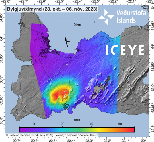
The yellow fringe is not visible at all at that place.
/Ulwur
Sorry, nevermind. I can’t read maps it seems. It’s not at all at the same place.
The steep gradient is real though.
Yes, the steep gradient is a fault line. You have one in the bottom of the inflated part as well, where it looks like someone took a bite. To the west of the fault, ground moved towards the satellite (lateral movement), making it look like extra uplift, to the east it moved away from the satellite, making the map look green there despite the uplift. Note that this was activity prior to Nov 6.
The intense quake activity the night between Nov 8-9 is not included here and I suspect there will be a lot of changes after that one. That quake included some vertical motion as well as lateral as evidenced by GPS measurements.
Rescue helicopter scouting the swarm zone https://livefromiceland.is/webcams/fagradalsfjall
I wonder if they have thermal cameras?
and gone – cam back to ‘normal’
I wonder what they noticed, if anything?
I noticed that too. not sure what they were looking for as someone rang the doorbell with a parcel. By the time I got back all back to normal.
Are the craters that were visible the Sundhnukur crater row? The helicoter was flying very close to them.
I would guess that most/all rescue helis have a thermal camera onboard, so it could be a scout of the area to see if there are any heat anomalies or visual signs like steam or cracks.
Could the craters/fissure line E/NE of Sylingarfell be a possible spot for a dyke to form from this ongoing intrusion? The magma hasn’t had any luck pushing through at Svartsengi so far, so perhaps it found a weakness to take advantage of and move horizontally under Sylingarfell to an old dyke system. There was obviously a dyke there once upon a time, hence the row of craters…
If only there was a GPS station to see whether that area is inflating!