
The stunning photograph of Thorbjörn Volcano was honestly stolen under fair usage for educational purposes, all rights remain with the Photographer.
Volcanoes rarely follow human timescale and human planning. This time it is Þorbjörn that decided to ruin things just after Albert had published a truly nice read about Santa Maria.
Þorbjörn better do as told below, otherwise Albert will have words with the volcano in question for ruining his article scheduling.
Background

Longterm GPS-trend data, Image by the Icelandic Met Office.
In the last 4 years the Reykjanes Fires have kept us amused, and as Þorbjörn is getting closer and closer to erupting I thought we should begin with a short recap.
Before Fagradalsfjall erupted 3 times it all began with Þorbjörn suffering from a powerful earthquake swarm, and an intense inflationary period where it uplifted 80mm.
The magmatic intrusion stopped that time at around the 5km mark, and since then the magma has been sitting there in situ, waiting for better times, and instead we got the 3 Fagradalsfjall eruptions as the pre-show amusement.
The first of those was a pretty tourist eruption that continued for quite some time, the second one threatened to overrun the road, a couple of houses, and burial site. Thankfully none of this happened.
And the third one was fairly unremarkable as Icelandic eruptions go, but the tourists that got there in time got their money’s worth at least.
Last few weeks

During the last couple of weeks Earthquake activity resumed over at Þorbjörn, and that in turn developed into a proper earthquake swarm with magma-tectonic earthquakes. But, to muddle the waters a swarm also started toward the tip of the Reykjanes peninsula, but those earthquakes steadfastly remained tectonic in nature.
About a week ago rapid inflation set in as the intruding magma pushed up the area above, and this inflation can be seen well across the entire Reykjanes Peninsula. By now the inflation has reached 60mm, plus the 80mm that was intruded in the last seismic crisis, so in total the area has inflated 140mm.
The GPS gives this as 100mm in total, but that is due to subsidence caused by Fagradal, and due to the area naturally subsiding over time. But the area directly above the magma is 140mm higher than what is should have been compared to other non-affected areas, if you catch my rift (drift).
Earthquakes

Happy little “bendy” low-frequency earthquakes, image by the Icelandic Met Office.
If we track the earthquakes that are larger than 2.5Mw we end up with them peaking at about 2.1km, those that are smaller are not well defined enough to be able to pinpoint depth enough to really be trustworthy, so let’s stick with the 2.5Mw as a good marker for what is a minimally trustworthy earthquake (no earthquakes are ever trustworthy…), and only if it has a 99 percent marker and is corrected by hand.
2.1km is at, or very near the border of where a volcano will become a runaway train in regards of erupting, due to buoyancy the magma will continue upwards if left alone, and 400 meters higher and it will start to nucleate out volatiles, and at that point nothing can stop an eruption from happening.
Regardless of this, the earthquake swarm is continuing due to magma building up the pressure, so it is not even left alone to its own devices.
Contractions


Breyting plots by the Icelandic Met Office.
At 00.04 Sunday morning the mountain suffered from a sudden strain increase at the same time as there was an earthquake doublet.
If it had been a drunkard outside a pub, this was the first dry heave before that type of eruption. And if we would state it with another physical human process, Þorbjörn had a contraction but the birthing canal was not dilated enough.
During that time there was a tremor episode also indicating that it was one of those “close, but no fish” situations.
But when contractions have started there will be a baby in the end. Yes, it may be a false contraction, and the baby will shoot out a few days later, but it is sort of assured that soon you will need a mountain of diapers at hand.
Now it depends on how fast the earthquakes breaks open the volcanic birthing canal, I do not think it will take a long time.
Eruption time?

Happy little tremors recorded in Grindavik, image by the Icelandic Met Office.
I would say that it is pretty close, at anything from a few hours, up to a couple of weeks. The Icelandic Met Office has it as within a year, but that statement came prior to the last 24 hours.
I would definitely take a bit of time to go out and grab some popcorn and find some nice webcams of Grindavik.
Eruption spot?
Volcanoes that have a fissure line like Þorbjörn are tricky to say where they will erupt specifically, but a good guess would be 3-5km from the town centre of Grindavik towards the Þorbjörn mountain itself.
This is a tricky spot since magma pouring out there relatively quickly would get to the town. There is also the potential that the dyke will propagate further south near the surface and pop up in someone’s basement.
I seriously hope that the last thing will not happen since it would be dangerous.
Conclusion
Þorbjörn is close to erupting now, and if it happens it will most likely impact the lives of the citizens of Grindavik. I do know that they are well informed and are ready to go within minutes of notice, and if it pops up at around where the earthquakes are heading, there will be time to evacuate.
I am not sure if the Icelandic authorities will try to save Grindavik by digging trenches and spray water on the advancing magma front like they did under Fagradal 2 and the Heimaey eruption respectively, but I would sort of assume that the Icelanders will have a go at it since they tend to fight their volcanoes.
CARL REHNBERG


Just noticed a new update on IMO
in the Reykjanes-Svartsengi volcanic system More
Interferogram (InSAR) for the period 28th of October – 6th of November shows that deformation in that period is around 7 cm. SW of Mt. Þorbjörn is an offset in the deformation signal caused by fault movements by earthquakes.
Magnitude 4.1 earthquake east of Sýlingarfell
Ongoing seismic activity on the Reykjanes Peninsula. Around 800 earthquakes have been recorded since midnight
10.11.2023
Updated 10. November at 2pm
Earlier today, at 12:44, an earthquake of magnitude 4.1 occurred near Sýlingarfell, west of Sundhnjúkagígar. The craters are about 2-3 km northeast of Grindavík. A dense swarm of earthquakes began around 07:00 this morning in the same area, and nearly 800 quakes have been recorded since midnight, including 9 greater than magnitude 3. The depth of the earthquakes is about 5 km. Such earthquake swarms have previously been recorded in this area. It cannot be ruled out that the seismic activity near Sundhnjúkagígar is due to magma movements at depth.
Magma accumulation continues near Þorbjörn at the same depth and at a similar rate as before. It is accompanied by swarm-like seismic activity, as was noticed yesterday and this morning. While magma accumulation continues, ongoing seismic activity can be expected due to stress release in the area. Earthquakes up to magnitude M5.5 can be expected in such swarms, and the seismic activity may shift between areas. At this stage, there are no indications that magma is forcing its way to the surface.
The swarm is really intensifying again.
The webcams are shaking!
Wind!
Fagradalsfajall cam zooming in on the craters again.
3.3 at 15:52 – made the Fagfadalsfjall camera shake.
It definitely seems to be ramping up the quakes again. Interesting times.
7 quakes larger than 3, with a 4.3 and a 3.9 since midday.
And there are some shallower ones in the mix, too. Most are still 4-6km but a handful have been 2-3km.
And now some in the 1-2km range. Very small but still…
Most probably it’s wind. The >M5 when Iceland’s PM was being interviewed live on US TV before the first Fagradalsfjall eruption didn’t show much on the live webcam (rewind) at Austurvollur, which is near parliament.
BUT, having now seen the video from just before 5.00 pm (Iceland) on the RUV live news I don’t think that the shaking was caused by wind.
Another 4.1 as well
I’m seeing steam and red glow from the svartsengi webcam. At the risk of jumping the gun, is this it? Or just floodlights and steam?
I think just lights switched on as the afternoon is turning to dusk.
Cant see anything at all that I havent seen before there.
Yeah, from that exact location it’s probably lights, it’s just that I got too eager and thought the color of the glow more strongly resembled redder lava instead of sodium lights
easily done and there were a row of redder lights but too neatly in a row at the top of the building. Could even be last rays of the sun shining of the windows, a very easy mistake to make. I personally now would place my eruption place to be somewhere along the row of craters seen from the fagradsfjall cam.
475 earthquakes in a 7-hour period of the swarm, concentrated in a very small area of 1 by 2 kilometers near the highest elevation part of the Sundhnukur fissure swarm (last erupted 2000 years ago). In the map, the blue translucent balls are earthquakes and the red line is the Sundhnukur fissure swam. The largest cones of Sundhnukur are right where the earthquakes are happening, and the highest elevation cone is 1 km away of the earthquake concentration maximum. So my guess is that the feeder plumbing of Sundhnukur is flaring with earthquakes.
All earthquakes since October 26:
Engineering question – those pipe lines coming from from the geothermal plant, i assume these are heat distribution systems to the local settlements? I would naturally assume they’ll be designed to be earthquake proof given their location, but how do the deal with the larger scale ground deformation that is currently occuring?
They deal with it by breaking at some point, possibly even melting. 😉
No seriously, such pipelines if designed accordingly can withstand an offset / shearing of at least half a meter or a lot more even. They zig-zag to allow for stretching and bending. But it depends where and how they are displaced.
Did you notice they are laid out in a zig zag pattern? That creates some slack for the length to change.
Many thanks, yes i did see those kinks/u-bends but assumed they had something to do with flow control/knocking, that makes sense.
The pipes with the u-bends are steam pipes connecting individual boreholes to the plant. Then there are two hot water pipes, with one going north to Keflavík and neighbouring settlements and one going south to Grindavík.
Yes, and Yes. There’s a hot water pipe (warm to the hand, even though heavily insulated) running parallel to the road down to Grindavik.
The pipes are on elevated concrete pillars, presumably to cope with vertical distortion and they have dog-legs built into them presumably to cope with lateral distortion but apart from that I have no idea how they are engineered to deeal with EQs or at what threshold they might fail. I am not aware of any having suffered damage obvious enough to cause power/water outages since 2021. Fresh lava-proofness is a different question, of course…
SHAKE IT, BABY! 🙂
16:56:26 4.1 NE of Grindavik – really shook the camera at Thorbjorn. Would have given the good people of Grindavik a bit of a jolt.
The Icelandic Meteorological Office has requested that rangers investigate the situation at Litla-Hrút, where unusually large amounts of smoke are now rising from the lava that flowed during the summer’s eruption.
https://twitter.com/FragenuberF/status/1723021763531944238
I saw the smoke on the Reykjanesviti camera, and was wondering about it.
And just to clarify I am referring to the ridge in the background and not the powerplant steam.
Middle distance ridge just left of centre on the Reykjanesviti cam, and far distance on the far left hand side of the Svartsengi cam?
Yes also saw what looked like steam from that old cone line/lava field in the distance. Looked hydrothermal and i think there are vents/hot springs in that area so assumed it was nothing eruption related.
The o/p is however is referring to Litla-Hrút (the eruption earlier this year) and i saw there were emissions also coming from those vents but assumed that is normal as those cones will still be cooling from the eruption.
Pretty impressive swarm popping off now lots of 3+
Impressive, same area that’s flaring up, under Sundhnukur.
The earthquakes in Iceland are nearly continuous right now. Can barely distinguish individual ones on the R1B4E raspberryshake station: https://dataview.raspberryshake.org/#/AM/R1B4E/00/EHZ?streaming=on
Aviation color code is orange now
Nice link!
isn’t the GRV drumplot looking a bit tremorish right now?
I think it is
Saw that. The low frequency is now also off the chart. Something is broken
This is indeed something.
Loooong shake right now.
Now the flight color code has been raised to orange: https://www.ruv.is/frettir/innlent/2023-11-10-fluglitakodi-faerdur-upp-a-appelsinugult-396242
Upwards and onwards. On the Litli Hrutur cam there is definitely smoke if you zoom in.
Friday
10.11.2023 17:30:36 63.880 -22.459 4.8 km 5.2 90.01 4.6 km N of Grindavík
now a 5.2
That area is prone to steaming, and can be particularly strong at times – especially earlier today.
It is just behind a ridge so hard to see what is really going on. But I’m sure it will be very obvious if anything interesting develops.
It is strange though how it turned to whie for a while then back to grey then white. looked like it was puffing but many strange things happenin Iceland. Maybe a little red Welsh dragon has taken up residence in a warmer place. Too much rainin UK at the moment.
Earthquakes over the past hour or so (removing some aberrant depth earthquakes 1 km deep or more than 6 km deep). They are still happening around the same spot. I still do not see the linear swarm of a dike, but the rock can’t possibly take much more.
I think it would be wise for the people of Grindavik and the Svartsengi power station area to be on alert and ready to flee. The Reykjanes geothermal station could also be in danger since that area has been involved in the crisis. I think it is not impossible for an Svartsengi sill to rotate into a Reykjanes system dike, the sill complex (if that’s what it is) reaches quite close to that area, and you never know where it’s going to burst.
A 5.2 combined with what is now an intense swarm looks like magma is likely to make a serious bid for the surface.
Yes, it’s as intense as it gets right now.
This on the civil defence web site. NB giggle translate in some places.
“Civil Defense’s danger level due to the intense earthquake at Sundhnjúka crater.
November 10, 2023 5:49 p.m
The national police chief in consultation with the police chief of Suðurnesj declares a state of emergency for Civil Defense due to the intense earthquake at Sundhnjúkagíga, north of Grindavík. Earthquakes can become larger than those that have occurred and this sequence of events could lead to an eruption. However, there are no signs yet that the magma is seeking the surface. The progress is closely monitored.
As before, residents are encouraged to follow information on almanvarnir.is, vedur.is and in the media.
The Civil Defense’s risk level means that the danger is increasing and measures are being taken to ensure the best possible safety of those who live/stay in the area. This is done by strengthening preparedness in the relevant area.”
Looking at the Fagradalsfjall web cam – plenty of flashing lights on the main road at the junction with the dirt track that leads to the Sundhnjúka crater field
Might give us decent idea where eruption. Don’t like to use exactly old line generally speaking and earthquakes seem skewed toward west side. Given different eruption style, fast and quick here, may not be able to pinpoint a specific place per se, long section might open up.
Declare the danger level to: State of Emergency
Police declares a state of emergency for Civil Defense due to intense earthquake at Sundhjúkagíga, north of Grindavík. Earthquakes can become larger and this sequence of events could lead to an eruption
I’ve been watching this livestream (https://www.youtube.com/watch?v=804nPrAUAxg), and there are so many big earthquakes coming fast and furious right now that the cameras are almost continuously shaking (and no, it is NOT the wind), and the stream even got knocked offline for a few seconds after one of the bigger ones. I don’t recall seeing the activity be this intense prior to any of the previous intrusions/eruptions since this whole cycle started.
Almost constant earthquakes now. I’m in Seltjarnarnes (town on the tip of the peninsula on which Reykjavík sits) and I’ve felt at least 10 in the last 90 minutes. It’s absolutely bonkers, I don’t remember a period this intense in the run-up to the three eruptions so far in Reykjanes.
Road 41 has been closed due to damage (cracks in the road), but it looks like cars are still driving there.
Picture of the damage:
https://x.com/gislio/status/1723044305864896974?s=20
Road 43, Grindavíkurvegur, is closed now. Hadn’t heard anything about 41 yet.
Sorry, that was a typo. Thanks for the correction.
“it looks like cars are still driving there” How Icelandic!
Fagradalsfjall camera has zoomed in on something, trying to work out the location
Lol, and now back to panning – cam operators must be jumping at shadows just like us lot on here.
Yes, lights also on the Thorbjörn cam. Maybe a team of geologists out there?
(No, that is most likely the coastal street south of Fagra.)
No, they’d know better. Probably volcanologists
I retreat now, so that I can be one with my humiliation [Niles Crane]
Earthquakes past hour. That looks like a dike growing along the Sundhnukur fissure line:
Red is 16:30-17:30 UTC, yellow 17:30-18:20. It does look like something broke. The earthquakes seem poorly located though, there’s too much noise:
It doesnt look like getting better anytime soon for sure! The cahrts are going crazy.
charts even. 🙂
Grindavik might be in trouble…
So many stars around the whole peninsula. Are these mostly ghosts or all real?
Many seem to be mislocated earthquakes, there are many stars located over the sea too which aren’t real. But where do the ghosts end and the real ones start?
I recall the person who goes by “Just Icelandic” flying his drone right over this region about a year ago and saying that he was worried about lava popping up here. How ironic if it does.
Is there a good recently updated site that has uplift? All this activity has to be pushing the ground around something fierce.
There’s this one at Thorbjorn:
You can see the contraction and then rapid uplift today.
Note that Thorbjorn has started to creep northward again, while Grindavik is moving south. The fault that is bing stressed at the moment I think runs from in between the two to the NNE where the big activity is. Anywhere along that line needs watching
Look closer. The northward movement is a single jump (big quake). After that it immediately started moving south again (you may need to squint a little through the noise).
Tremor is off the charts.

Looking at this cam.
https://www.youtube.com/watch?v=U9QEbirKQx4
Looks like they may be turning traffic back?
What angle is this? I guess the smoke is from the heat plant.
yes that is the hot steam.
I Have never seen EQ’s like this. ~2 per minute, Mag 2,5-3 at 1Km. I Guess we’re all on Carl’s runaway train now.
You have to feel sorry for the people whose job it is to verify the EQs. I imagine they’ve all given up and are lying on the floor under their desks, gibbering wrecks.
Huge dike is rapidly propagating in both directions, nearly 10-km long, it’s already under Grindavik, and has also reached the northern end of the Sundhnukur fissures. Red is 16:30-17:30 UTC, yellow 17:30-18:20, green 18:20-18:50 :
Then the lid have burst then
There’s quite some activity under Grindavik. A bunch of M3’s at 1Km right under the city.
Even if the magma does not reach the surface the intrusion will make quite a mess of things, cracks through roads, constant shaking.
Poor people. I would be out of there tonight. Even if I had to sleep in a car in Reykjavic.
I am a devot coward which is why I have reached my mid 70’s
It started growing sideways at some point after 17:30 UTC. It has grown to enormous length in a little over an hour. I think this confirms that Svartsengi is a different kind of beast from Fagradalsfjall. Let’s hope the dike does not make it to the surface.
Days rather than hours according to vedur.is.. I’m not that convinced.
Yes, as an inflating sill (horizontal sheet of magma). The change is that we now seem to have, judging from the linear distribution of earthquakes and the lateral propagation of the swarm, a dike intrusion. As it grows in length the earthquakes that are concentrated near the growing tip shift outwards.
The sill is spreading lateraly like liquid glass poured on a flat table thats what IMP says for the moment, so the roof have not cracked yet?
Is there any data on the inflation rates? are they the same or are they changing?
IMO Updated November 10 at: 19:00
The seismic activity that is currently measured at Sundhnjúka crater is limited to an area about 3 km northeast of Grindavík. The shallowest earthquakes that are currently measured are at a depth of about 3 – 3.5 km.
The signs that can be seen now at Sundhnjúka crater are comparable to those seen on the eve of the first eruption at Fagradalsfjall in 2021 and are very similar to the seismic activity that was measured about a month before the eruption. Looking at the sequence of events that culminated in the eruption that began on March 19, and while the seismicity has not subsided significantly so far, the most likely scenario is that it will be several days rather than hours before magma reaches the surface. If a crack were to appear where the seismic activity is at its highest now, lava would flow to the southeast and to the west, but not towards Grindavík.
https://www.vedur.is/um-vi/frettir/jardskjalftahrina-nordan-vid-grindavik-hofst-i-nott?fbclid=IwAR3RvIz1i8NfQG7Cj-nadJhqcR7KF9T9ONy9gBOFtV9Oczq_ruPjcoaFScY
Still going up a little
A little perhaps because the rest is channeled into the dyke now
I guess we will not be able to fully confirm a dike until we see a butterfly pattern in interferograms, or a fissure starts ejecting lava. But when there’s a lengthening line of earthquakes like this, it is almost certain it’s a dike.
It almost looks like the propagation has taken the strain out of the middle, but now its anyone’s guess as to where it is going to breach.
Is it just me that looks at that map, and thinks that the eruptive potential is hiding in plain sight?
Doesn’t look like we’re going to be able to do the ‘guess the eruption spot’ game! Shame, as my guess was going to be on the East side of Thorbjorn on that very line! It didn’t sit right with me that it was going to be under the area of uplift and that it would find a path in the direction of Fagra. I was basing it on the initial activity in 2021.
thanks for that insightful graphic.
Hector, what is your take on mafic lava being erupted? One of the Iceland geologists was worried about this possibility and a large gusher upon eruption at first.
It should be mafic, being the Reykjanes Peninsula. I wouldn’t be anywhere near the outbreak to be sure, unless it’s a tall hill upwind from the fissures. On the bright side, it’s growing so far out sideways that maybe that keeps it from erupting upwards.
Tons of cars on the Reykjanesviti webcam. Maybe some people decided to move preemptively.
People coming to watch the show.
These are Icelanders, they are not fleeing from volcanoes, they go to them with picknick baskets.
According to RUV lots of people are currently leaving Grindavik hence all the traffic.
I would be in one of them with everything I could move. Cowards live longer than daredevils and I really dont like what I am hearing about this almost inevitable eruption.
Most cars by far are going away from the show (right to left, which is east to west on Nesvegur).
I was somewhat teasing.
But, as soon as it starts to squirt they will turn around with full picknick baskets.
As any of us would, but meanwhile I’m sure they would rather sleep in a place that’s not constantly shaking with the risk of even stronger earthquakes.
I agree swiiscompos. I wouldn’t sleep a wink worrying I might fall into a fiery abyss. I sadly have an overfertile imagination as well as anxiety disorder.
True, keeping distance to the danger when you don’t have the situation under control is wise, then seek the danger out when its under fair control.
Convoys of trucks and equipment moving up to the powerplant on the webcams as they are starting to build the defense-wall tonight.
From IMO:
“The seismic activity being measured near Sundhnjúkagígar is confined to an area approximately 3 km northeast of Grindavík. The shallowest earthquakes being measured now are at a depth of about 3 – 3.5 km.
The signals observed near Sundhnjúkagígar resemble those seen in the lead-up to the initial eruption at Fagradalsfjall in 2021 and closely resemble the seismic activity recorded about a month before the eruption. If this sequence of events is viewed as leading up to the eruption that began on March 19 and considering that the seismic activity hasn’t significantly diminished from what it was, we’re likely looking at several days rather than just a few hours before the magma reaches the surface. If a fissure were to open up where the seismic activity is currently the most pronounced, the lava would flow southeast and westward rather than towards Grindavík.”
Westward?
= the main road and then possibly on to the geothermal plant?
Still, better than towards Grindavik!
Once a dike has formed, it still needs to fill with magma. So there may be a much quieter period before it is actually ready to erupt. But note that they are seeing ‘days rather then hours’. They would be as surprised as us if this doesn’t end with lava
Grindavíkurvegur has been closed east of Blue Lagoon, roughly at https://www.google.com/maps/place/63%C2%B052'24.4%22N+22%C2%B025'21.5%22W/@63.8734439,-22.4303543,15z

Source
https://twitter.com/gislio/status/1723044305864896974
That is some sexy landscaping.
The person next to the vehicle seems to be rubbing his noggin. Like he went over that jump.
And we in my town complain about a 2 inch deep pothole. Mind you, even a 2 inch hole gave me a burst tyre, Somethings to complain about indeed. 😉
Lol – The 9 year old me would be lining that up on my Raleigh Grifter!
Watching the tremors, this latest peak also involves the green and purple pens, which is new. I’ve no idea what that means.
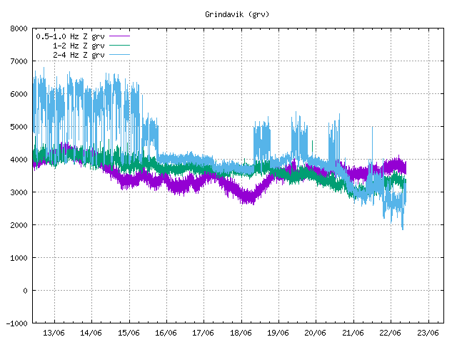
It’s different frequencies, the purple is the lowest frequency and the blue the highest. When there are big swarms they all move up but the blue tends to cover the green and the purple.
Thank you. So there’s something about this swarm that wasn’t true of swarms over the last week. Might be just intensity but could be other things as well?
“Many of the residents of Grindavík have started to leave the town, according to information from rescue teams.”
From RUV who has live-reporting in english now.
https://www.ruv.is/english/2023-11-10-civil-defence-level-of-danger-declared-live-396249
Thx!
That would be sensible. Even if lava does not reach Grindavík, they could have a rough time of it with earthquakes like 2021.
Best news I have heard all day from Iceland.
Earthquakes again plotted as translucent balls, red line is the Sundhnukur fissure system that the dike seems to ROUGHLY follow. Red is 16:30-17:30 UTC, yellow 17:30-18:20, light green 18:20-18:50, dark green 18:50-19:20:
The 19:45:15 Iceland local time mag 4.5 quake just offshore of Grindavik would confirm the expanding dike propagation to the SSW. depth is 2.7 km
Lots of emergency vehicles at the powerplant now.
I hope that nothing burst in it.
A fire was reported to have broken out half an hour ago, but according to the emergency units at the site everything is under control.
Carl
How long would it take to get the plant shut down in a safe manor?
Mac
Hard to say really, depends a lot about how it is set up, and where they have valves to release steam without underpressuring other parts.
Anything from minutes to a day.
I read that the defensive wall was to be started tonight. Perhaps that is what is happening,
M4 underneath Grindavik in the last ten minutes. You have to feel for the poor bugger at IMO who has to manually verify the location and strength of all these earthquakes! Might be running a little behind.
Confirms Hector’s observations about a growing dike, as this quake is right in line with the SSW propagation spead, just offshore Grindavik
To manually get a rough correct location on an earthquake takes ~5 minutes, maybe less if you’re in a hurry and it’s not complex.
To get a refined robust solution can take up to 20 minutes.
They’re running WAY behind! And the complication here is there’s so many earthquakes right on top of each other – a lot of those automatic mislocations, stars out in the middle of the sea etc, will be ‘ghost’ locations where the automatic system has combined bits of energy from more than one earthquake to try to find a solution. Disentangling all those wrong picks takes a lot longer.
Could AI learn how to?
I’m sure they are already using it to a certain degree, even if it’s in a testing phase behind the scenes.
Not sure i’ve ever seen one of these en vedur graphs look like this. I’ve seen it look like it was at midnight on Thursday with Fagradalsfjall. It must be having a tough job breaking through the crust for the first time in 800+ years, a lot of pressure.
Hi, long time no see but Iceland looks scary, never seen such a galaxy of green starts on map!

Stars spangled banger.
It was lively in 2021 in the run up to Geldingadalir.
absolutely nothing like today has been though!
I watched 2021 lively. It was a walk in the park compared to hiking up an active volcano. In my view today has been horrendous and the amount of people leaving Grindavik tonight is my proof of that. Icelanders don’t scare easily. Today they WERE scaredand proved it by leaving their homes,
It’s safe to say that these have been the worst three hours for Grindavík since this whole thing first started in December 2019.
Common sense to leave, especially if you would find it hard to evacuate at short notice – at least until there is more clarity over what’s going on. In 2021, people left their homes as the earthquakes (a lot of 4’s and a few 5’s) were preventing sleep – there’s only so long you can safely go without sleep.
Not seen any mention of the potential hazards from volcanic gases …
Not saying that 2021 was worse than now; I am not there. People in Grindavík would be better to advise.
Tremor is starting to come down now.
That was a surprising jump – almost as if it nearly broke through then failed.
Videos from people in Grindavík are in this article: https://heimildin.is/grein/19559/otti-medal-ibua-og-oroi-maelist/
https://twitter.com/volcaholic1/status/1723063892295684256
So that’s how being on top of a growing magma intrusion looks…
The dike seems like it is still extending in both directions, and the Grindavik side seems to be getting the worst of the deal. I am pretty impressed by the speed of propagation. The sill area seems relatively quiet now, it may take some time to repressurize.
Earthquakes again plotted as translucent balls, red line is the Sundhnukur fissure system that the dike seems to ROUGHLY follow. Red is 16:30-17:30 UTC, yellow 17:30-18:20, light green 18:20-18:50, dark green 18:50-19:20, light blue 19:20-19:50. The intrusion doesn’t seem to be growing sideways anymore so I will stop making these for now:
The (almost certain) dike intrusion is 12 km long. It may or may not erupt. During the Krafla Fires only half the dikes erupted, and only the last ones did large outbreaks. The early dikes were either non-eruptive or did very small effusions. This is not Krafla but it may not be too far off.
This might very well be the end of the Fagradalsfjall Fires, and the start of the Sundhnukur Fires. Iceland better get those walls up quickly and hope this first dike will stay safely underground.
By IMO report, this is sill, not a dike.
Has there been a new InSAR image?
Up until about 4pm, it was…
Dyke on its way to the surface now
I agree with you Jesper, whether sill or dyke, magma is coming up in my opinion too. I personally think the violence of this last earthquake swarm has started a runaway train.
They say been confirmed by goverment agency FB pages
Magma tunnel to surface forming
The Met Office’s meters have shown clear signs of the formation of a magma tunnel to the surface. This is stated in a notice from Civil Defence.
There is still the highest probability that magma will emerge north of Sundhnúki, and therefore lava will not flow to Grindavík, in accordance with the lava flow model that was run earlier this evening.
Utility company HS Orka asks Grindavík residents to contact them on 422 5000 if they are aware of flickering electricity supplies.
Is that from the new GPS etc they were installing the other day?
Well Héctor Sacristán, the IMO agrees with you, about a hour later (but probably due to utmost caution on their part to get things right) Congratulations
https://www.youtube.com/watch?v=804nPrAUAxg
Nice little 4-way setup. It will be better for seeing eruptions at daybreak or twilight however. Seems to go from day to pitch black night in the blink of an eye this time of year.
Currently the activity seems to be concentrated on the two extremities of the dike.
Forgot the picture: https://imgur.com/a/3QKAoAy
Let me try again:
Activity is actually declining a bit. About time.
Lots more shallower quakes showing up now though. Of course they are only checked to a 90% so not totally proven but the quantity of shallower quakes has increased a lot. Not all of them tiny quakes either.
Here’s a close/strong/shallow/verified one:
Friday
10.11.2023 18:46:42 63.850 -22.430 1.7 km 4.0 99.0 1.4 km NNE of Grindavík
Confirmed earthquake for today reported on https://skjalftalisa.vedur.is/#/page/map. (they have focussed on the larger quakes?).
Everyone might find this interesting now from a year ago June 5 – https://www.youtube.com/watch?v=PoxooetECXM
I went to login rather than just read VC and found that the last time I did so was 12 years agao, and guess what….
So I now have a new account to post here.
I thought this was worth noting, whilst the SW corner of Iceland is getting rid of all the stress and strains that it is finding unbearable – it is having wider effect around the country as all the rocks that have mostly being happily co-existing try and settle themseves into the new “new”
[I tried to post a jpg, but whatever – is someone could screenshot this as it is now – it is worth preservation as it is rather rare:
https://en.vedur.is/earthquakes-and-volcanism/earthquakes/
Hi and welcome back… that’s not so. All the seismicity is in a small area on Reykjanes; the quakes that appear to be scattered across the whole of that part of Iceland don’t actually exist, they’re ‘ghost quakes’ created when the automatic system takes bits of energy from different earthquakes and tries to associate them into a solution.
From RUV:
Work to build defenses along the way
More on that briskly activated plan to build defenses around the Svartsengi power plant.
Civil Defense says it is underway and on schedule.
The defenses will be four kilometers long, and six to eight meters high, and will protect the power plant – and the town of Grindavík.
IF…. they can finish it in time. They may have dragged their heels too long on this one. However they are talking about working on 4 areas at once so for everyones sake in that area I hope the quakes hold off enough to give them time and they arent trying to “lock the stable door after the horse has bolted.
They tested the design at Geldingadalir. All they have to do is move earth. (OK a lot of earth).
If they have the days, they think are most likely, they may be able to do do it.
Here’s hoping the lava emerges where and when currently predicted.
Okay, so if Iceland is declaring war on Thorbjörn I officially will name this into Avdivkahraun.
Cheech, haven’t seen that long and high a defence line since…
Some deeper EQ’s are showing up in Svartsengi. At 12 and 15 km. Is this newsworthy?
There is a 2.8 at 44.7 km depth at 21.48 I saw too.
It seems there is confirmation of a dyke with magma moving to the surface: https://www.mbl.is/frettir/innlent/2023/11/10/mjog_skyr_merki_um_kvikugang_til_yfirbords/
Just in from RUV
The Met Office’s meters have shown clear signs of the formation of a magma tunnel to the surface. This is stated in a notice from Civil Defence.
There is still the highest probability that magma will emerge north of Sundhnúki, and therefore lava will not flow to Grindavík, in accordance with the lava flow model that was run earlier this evening.
Source: https://www.almannavarnir.is/frettir/skyr-merki-um-myndum-kvikugangs/
Unless I am wrong, wasn’t Hector the first to post the dike formation?
On VC, yes. This is more of an official acknowledgement from Almannavarnir.
As a laterally propagating dike, and here, yes. There was an important change that happened around 6 UTC, many small earthquakes building in magnitude and frequency within a small area, which was probably the start of the dike in a very subdued manner, or at least something that immediately preceded its formation, and Jesper picked up on it too and said it could be a dike, and was actually the first to comment as I was thinking the same. From that moment on I was on top of the swarm and commented as soon as it started to show lateral migration that was strongly indicative of a dike.
I do expect at least some of the scientists from IMO realized as soon as they saw what I saw. But not all volcanologists are as experienced, and back during the Taal eruption of 2020 I talked about a major dike intrusion that was taking place and that PHIVOLCS never talked about, and maybe still doesn’t even know about. The Taal dike eventually showed up in a scientific article a year later or so.
Do we know yet how far the dike is from the surface? Wondering if this will pop while im out on a hike instead of glued to my PC 👀
Isn’t that the rule with all volcanoes? They start erupting the moment we are not looking.