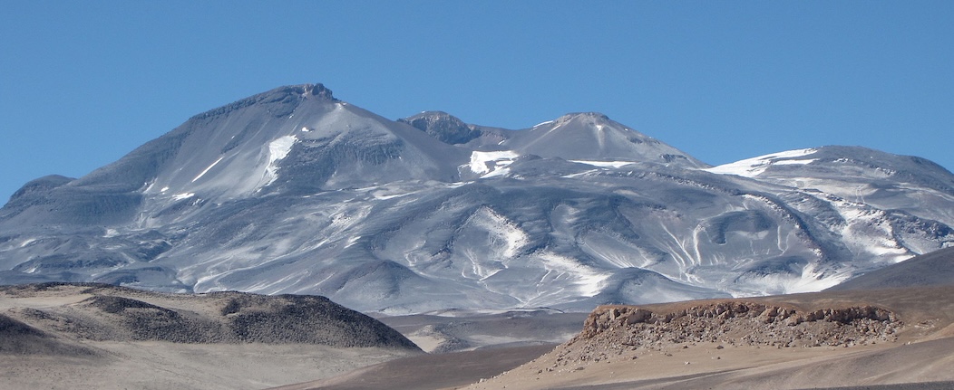
The highest volcano in the world is Cerro Ojos del Salado. It is a stratovolcano in South America’s Central Volcanic Zone, reaching an impressive 6893 meters above sea level (or at least above what sea level used to be). It doesn’t look much: the volcano is a mess of overlapping domes with two separate summits, with the border between Chile and Argentina lying along the two summits. It is an old volcano which has existed since the Pleistocene. There is still some activity: the volcano is dormant rather than extinct. The most recent eruption may have been 1300 years ago, and explosion that deposited tephra in the region. But the activity is low enough that each eruption has to create a new magma path. This is one reason for the disheveled appearance: each eruption creates a distinct feature. There are some 20 separate craters. One of these carries the highest crater lake in the world.
Ojos del Salado. Source: wikipedia
The tallest volcano in the world is Mauna Kea. It stands 4207 meters high. Mauna Loa, the next-door neighbour, reaches 4169 meters. These are puny compared to Salado. But when measuring the height from the surrounding sea floor, the Maunas have it. Mauna Kea becomes 9330 meters tall and Mauna Loa is not bad either, at 9170 meters. Eat dust, Ojos del Salado!
Mauna Loa does have the claim to be being the biggest volcano in the world. It is a shield volcano and therefore very wide. The volume is reported at 75,000 km3, giving a total weight of 200 thousand gigatons. That is 200 times the weight of all the buildings in New York. This beast is badly obese. In fact that is to its own detriment: its weight has depressed the sea floor underneath. It is filling a hole it dug itself.
There is some cheating involved. Mauna Loa looks (reportedly) like an upturned whale, and indeed it has a whale of a time. The bottom 5 kilometers of its edifice, accounting for most of its mass, is below sea level. That means the weight is partly carried by the water – as any slightly overweight person knows, the quickest way to lose weight is by submersion. That has allowed both Manaus to grow a bit more than they would have done on dry land. It also means that with the 20-cm of sea level rise we have had so far, Mauna Loa is able to grow 7 cm or so taller than it did before. By 2100, that could be 20 cm. We are not changing our weather, we make our island volcanoes grow taller.
The question was asked, how high can a volcano get? That is not easy to answer! But we can try.

The world’s tallest volcano: Mauna Kea
Prominence
It makes sense to look beyond the elevation of a volcano to judge its size. Europe’s largest volcano is not Etna. There are several higher volcanoes in the continent, with Elbrus as the number 1 and Kazbek at number 2. Even the Keli volcanic highland stand higher than Etna. But all three (or four, if counting the twin peaks of Mount Elbrus as separate volcanoes) start with an advantage: they have grown on the non-volcanic massif of the Caucasus. It is easy to win a high-jumping competition if your starting elevation counts.

Mount Elbrus, Europe’s highest but not tallest volcano
The prominence of a volcano is measured from its surroundings. That reduces Elbrus to around 2 kilometers. The same is true for Ojos del Salado, which grew on the high plateau of the altiplano. They are also-rans. In contrast, the two Maunas have a prominence that is much more than their elevation. That is also true for that other well-known giant, Olympus Mons on Mars. It has an elevation of 21.9 km (measured above ‘datum’ which is the Martian equivalent to sea level) but a prominence of 26 km because the surrounding land lies several kilometers below datum.
Sometimes it is difficult to know the true prominence. In the case of an island volcano, the depth of the sea floor may be hard to measure. Or the area may be covered with lava flows and it is not clear which volcano they came from, so do they count? Kilauea has grown on the slopes of Mauna Loa, but how deep lies the dividing line? In fact, all Hawaiian volcanoes sit on the slopes of their predecessors, so this problem is not unique to Kilauea. In practice, we take the largest current volcano as being responsible for everything underneath.
Also, note that filling holes does not count. If you built a volcano in a deep crater which it fills up, then only height above the surroundings count. On the other hand, if the volcano is a peak inside a caldera, then it is measured from the bottom of the caldera. It sounds unfair, but that is the rule of the game.
The rise
How does a volcano grow? The obvious answer is that it spits out lava and this creates the mountain. We can currently see this in action with the twin fountains of Hamaumau, which are not only erasing a caldera, but have built a 20-meter tall tephra cone on the caldera wall. But this is not the full story.
In fact, it is more of an afterthought. Since where does that lava come from? Where was it before it erupted? A volcano is just an elevator carrying magma from below to the surface. Basically, since the magma was already there, why would its vertical transport change the total elevation?
Indeed, the initial rise of a volcano precedes any eruption. It rises because magma accumulates below the surface. But doesn’t this just move the problem downstream? Where was the magma before it accumulated there?
The answer is expansion. Rock may seem pretty solid, but it can change its volume and when it does, this creates an irresistible force. Its volume increases when it becomes hotter – very slightly, but the temperature change can be large. If there is a mantle plume below the surface, the heat this carries up makes the rocks underneath warmer and larger – and the ground inflates.
More significant expansion occurs when the rock melts as well. Now the rick may expand by 10%, and this has immediate impact. So it is the melt that forms the magma that is the main first cause of the volcanic rise. The cause is the fact that rocks underneath are becoming less dense. And like a cork in water, this pushes the land up.
The basic model for the uplift was devised by a Japanese seismologist called Mogi, and with all the creativity of scientific language, is called the Mogi model. It assumes a spherical magma chamber, with a certain diameter and pressure, located at a depth below the surface which is much larger than its diameter. This round blob pushes up the surface over an area beyond its own diameter.

The Mogi source model for uplift from a magma chamber
The deep magma at the bottom of the crust is mainly located in sills, and this spreads the rise over an even larger area. The surface rises, but it is diluted because ot happens over such a large area. Magma formation is also slow, and this rise may occur over near-geological time scales. We see the bulge, but don’t normally see the rise. There are exceptions: Uturuncu, another twin-peaked volcano (why do volcanoes split so often? And should we call it multiplication or divorce?) in the Andes is rising by a centimeter per year and has done so over decades.
These bulges can be enormous. Before a flood basalt, massive amounts of magma accumulate at depth. These can push up the land by a kilometer or more, over a thousand kilometers across. If this happens below sea, the sea level rise across the world can be ten meters or more.
Location, location, location
The three most important aspects to consider when buying property are listed above. Everything else is secondary, or even quadronary. That is true when siting volcanoes as well. Why do the Caucasian volcanoes start out so high? What pushed up Ojos del Salado?
The answer is the same as before, just without involving heat or melt, meaning it is non-volcanic. These volcanoes are built on mountains. So what makes non-volcanic mountains grow?
There are two aspects. First, they are built on continental crust. Oceanic crust is made out of mantle material: it is dense stuff. Continents are mainly made from silicates, such as granite. This material is less dense, and this has made the continents rise. This is why seafloor is flooded and continents are not (with exceptions, of course). In a human analogy, mantle material has more muscle (higher density) and continental crust more fat (lower density).
The amount of the rise depends on the thickness of the crust. In places such as the Afar Triangle, the crust has thinned and this made the land sink. This suggests that non-volcanic mountains form where the crust is very thick. And this is correct. A continental collision forms a crumple zone where the two crusts are squeezed together. This makes the crust twice as thick, and therefore it rises twice as far. Roughly speaking.

The Grand Teton mountains in Wyoming, possibly the visually most impressive mountain range I have seen
This tells you something else: composition matters. Shield volcanoes are mantle-like in their composition, therefore have higher density and tend to sit a bit deeper. Stratovolcanoes are made out of more silica-rich, lower-density magma and sit a bit higher. That in itself may make a 10% difference in the prominence.
From bulge to peak
Clearly, there is more about the rise of a volcano than a large inflated bulge. They are prominent peaks above the surroundings. How does that happen?
It comes from another aspect of the Mogi model. A deep magma chamber pushes up the land by a small amount over a large area. A shallow one produces inflation that is much more focussed: a larger amount over a smaller area. The change from bulge to peak begins with one from a wide bulge to a narrow one, caused by the upward migration of the magma.
It is this aspect that makes tilt measurements difficult to interpret. It may be caused by deep magma, in which case a small tilt can be due to a large magma volume. Or it can be from a shallow chamber, giving a much larger tilt for the same volume. It also depends on where the tilt is measured. Put the instrument on top of the intrusion, and it will show no tilt at all. Put it far away and the tilt may go down as the magma rises. To make sense of tilt, you need to know where the magma is located. Mogi tells us so.
Finally, magma makes it to the surface. From the previous discussion, there will probably already be a bulge in the landscape. But as the fresh lava comes out, it quickly builds a better peak, with a strong prominence. The conical shape of volcanoes comes from the surface lava flows. The higher the viscosity, the less the lava flows and the steeper the cone becomes. Shield volcanoes have low viscosity lava which flow easily: they build a shallow edifice. The bottom line is that a shield volcano needs much more magma to reach the same prominence as a stratovolcano. Luckily, because shield volcanoes get their magma from deep heat, they normally have a much more voluminous magma source. Low production rates tend to produce shields which have so little prominence that they can be hard to recognize. There are some examples on the Reykjanes peninsula, but they are not the peaks that draw the tourist’ eye.
Down again
So this is how volcanoes grow. But clearly, there are limits to the growth, as pointed out by the Club of Rome many decades ago, or by Thomas Malthus long before that. What are the limits for volcanoes? The fact that Mauna Kea, Mauna Loa and Everest are rather similar suggests there is a limit. In fact, Olympus Mons is not dissimilar: Mars’ gravity is about 38% of that of Earth, and 38% of 26 km (the prominence of Olympus Mons) is 9.8 km which is only a little higher than the prominence of Mauna Kea. Is this a natural limit?
The problem with volcanoes is that they may grow very fast. They can end up becoming unstable. A stability analysis is insufficient: they may not be stable. So a better question is how high a stable volcano can be.
The same question can be asked about mountains in general. Why are some mountains higher than others? For instance, the Japanese mountains pushed up by the subduction zone are on average only around 1km high, while on the other side of the Pacific, the average height is 5 km. These are notable differences.
One suggestion is that the height of mountains is determined by the balance between the tectonic growth rate (how fast mountains are pushed up) and the erosion rate (how fast they are taken down). As mountains become higher, glaciers form on their slopes and they greatly enhance erosion rates.
The other suggestion is that it is limited by a spreading force. The weight of the mountain pushes down on the subducting plate. This is balanced by friction at this interface and by viscosity. If the weight exceeds what these two forces can withstand, then the subducting plate will be forced to move faster and the mountain will sink until the forces are in balance again.
The second suggestion seems to fit the height of the various mountain chains well. This is shown in the figure where the average mountain height is compared to what the subduction zone can support.
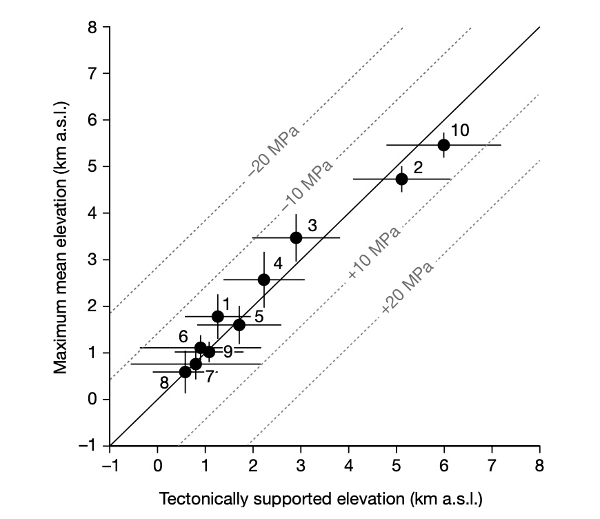
Source: Armin Dielforder, Ralf Hetzel & Onno Oncken, Nature, volume 582, pages 225–229 (2020)
This suggests that tectonics limits the height of mountains. Specifically, this is caused by friction and viscosity. But note that it does not limit the height of individual mountains in the chains. These are small enough that their weight gets distributed over a larger area of the deep subduction zone. As long as they are separate peaks, they can survive.
Is there any other limit? There is another important one, and it is caused by another transition zone. Underneath the crust lies the asthenosphere, a region where the mantle rock are hot and weak, and are even a little molten. Put this under pressure and it will flow sideways. It is a slow process because the viscosity is still very high. This is what caused the ground to sink underneath the weight of the glaciers of the ice age, and the rebound afterwards. In many places this rebound is still un-going. It limits the height of mountains but acts very slowly. If the mountain grows quickly, it has no problems. But over a millennium and longer, the asthenosphere will give away and the mountain will sink. In fact, even New York is isostatically sinking.
This is a much worse problem for volcanoes than it is for ordinary mountains. Volcanoes require heat, and this heat increases the melt fraction and weakens even the crust. So the response is much faster than it was during the ice age. This effect is at play at Mauna Loa. Away from most lava flows, the subsidence is measured along the coast: at Hilo it amounts to around 5 millimeters per year. Mauna Loa itself is compensating for this from intrusion of new magma and of course regular eruptions, but overall Mauna Loa appears not to be growing anymore, as shown by the subsidence on its distant flanks. Other volcanoes also show this effect, battling subsidence with growth. Hekla is an example of a young volcano where the crust has not yet adjusted to its weight and is giving way, but the eruption rate more than compensates.
Once a mountain stops growing, erosion kicks in. Volcanoes often suffer flank collapses. These remove much of the weight, and allow the remainder to survive. Also, when volcanoes go extinct, the heat below is gone and the crust re-strengthens.
There is one more limit to consider. A cold, stiff crust can carry more weight, but is also subject to faults. These faults give way long before the crust itself does. All mountains have this problem, and these faults are often relatively shallow, so sensitive to local, small-scale effects. It may be that these faults eventually limit how large a single peak in the mountain range can be.
Bottom line
So what sets the limit to the size of a volcano? All these effects come into play. For large volcanoes, the limit they run into is the growth rate versus the isostatic subsidence. As a volcano get larger, and especially for shield volcanoes with their large bulk, the growth rate declines as more and more volume is needed for adding each centimeter of height. Eventually, this runs into the buffers. Finally, we have seen that more and more of the eruptions occur on the rifts – and these don’t add height to the summit. Rift eruptions become more likely when the volcano grows taller.
Stratovolcanoes may seem to be a better bet, because they have less bulk (steeper flanks) and also weight a bit less for their volume. Also, they have less heat underneath so have less problem with the asthenosphere giving way. But in reality, stratovolcanoes do not have prominences near those of the Maunas, so clearly they have a problem. Two problems, in fact.
Their first problem is that the magma supply is typically low, and therefore the growth rate is small. This makes erosion the limiting factor. There are exceptions, for example Bagana may be the fastest growing (and youngest) volcano on Earth. But such rapid growth tends to be limited to the early phase, before the initial magma supply is exhausted. The second problem is that when these volcanoes age, they tend to blow their tops. Mount St Helens is a good example. These explosions set their own limits to the growth.

Bagana, the world’s fastest growing volcano. Source: Oregon State University
So why did Cerro Ojos del Salado grow so large and survive for so long? It had two advantages: a very long-lived (albeit low level) magma supply from the subduction zone, and an extremely low erosion rate. The Central Volcanic Zone of the Andes is located in the driest region, with little rain and few or no glaciers. Erosion is mainly from wind and rock can last a long time. As it has done.
How can a volcano reach its limits? The best recommendation is to go for location, location, location. Where is erosion at its least? It is under water, where there is no rain or wind, and wave erosion is limited to about 50 meters below sea level. Submarine edifices can live as long as the ocean flor they grow on. But for reaching the heights of the Maunas, they have to put their heads above water, with all the problems that entails.
There is another way. Go for a place with less gravity, a stronger crust and no erosion. Olympus Mons got it right: go for Mars.
Albert, June 2025
For Olympus Mons, we refer to Henrik’s story: Mars 2067, the Olympus Mons Expedition


Wow, wild scene now at Kilauea, looks like a tephra tornado back of the fountain, tearing up the landscape, and looking very ominous. Time are 12:15 pm Hawaii time (Sunday 29-June-2025) This on the V1 Cam https://www.youtube.com/watch?v=oG5zz9Sjw3E
Fountain blow-out at 12:18:10 pm, something broke apart from too much pressure. V1 Cam
This episode is absolutely insane.
Saw that too. Very wild, maybe just a combo of heat from the tephra/fountain and wind geometry is the things that make this monster of a whirlwind…
Get this quite a lot here in summer, as our bushfires cause fire tornadoes. Stands to reason that a source of heat like the Kilauea fire fountain would do the same.
Could use a bit of warmth here right now. It’s mid winter and an east coast low is about to hit Newcastle. Such beasties often cause blackouts for several days, so you may not hear from me for a while. One ECL, which was named the Pasha Bulka storm after a bulk carrier that was stranded on Newcastle’s main surfing beach, dropped a tree onto my house. Fortunately not much damage, but it looked like the house had a green toupee. The local volunteer fire brigade guys came and got it off for me.
Mauna Kea and Olympus Mons both have a secret advantage in the altitude stakes. You touch on it Albert right at the end: “Go for a place with less gravity”.
That’s obvious for Olympus Mons, but is also true for Mauna Kea. Hawaii is sitting in an ocean 5.5 km deep – due in part to the ginormous volcano sinking the oceanic crust surrounding it.
Water, though, is buoyant. So that 5.5 km deep column of seawater is floating Hawaii upwards even as Mauna Kea tries to sink it. The volcano is tall because it is standing, or more accurately floating, on the shoulder of the giant called the Pacific Ocean.
Olympus Mons of course has the advantage of low Mars gravity, which is like buoyancy, but without water. I wonder how high the volcanoes on Io are, since the gravity of that moon is even weaker than Mars?
Slight objection, the highest volcano is Aconcagua, which is also the highest peak in South America. On the other hand she is now clearly extinct and is only 68 metres taller than her feistier brother.
The gravity advantage of Olympus Mons is mentioned earlier on in the post. So is the buoyancy, but not Aconcagua which I had overlooked. The fact that first place is often a close competition shows that those volcanoes are reaching their limits.
Aconagua isnt a volcano, its a fold mountain made of volcanic rock. There might have been a volcano at this location before but the mountain now is formed by diffrent processes so it shouldnt count.
Its actually very hard to find any information about this, the claim is that it was an active sttatovolcano that stayed alove for the totally unrealistic time of over 50 million years from the late Cretaceous to the Miocene, then uplifted. But nowhere provided an actual geologic study of a single system active for so long or the logic for thinking it.
Low, shifting wind and a blocked conduit–hope the crowd at Keanakakoi is on the ball.
Kilauea Message 2025-06-29 11:40:40 HST
Lava fountains erupting from the north vent are up to 1,115 ft (340 m) in height as measured by an HVO field crew. Winds are light and variable; tephra is falling within the crater and to the S-SW.
I guess the fountain reached up to that height and still maintaining height in spite of the fluctuations.
Maintaining as in fluctuations in height ang getting back to being over 1,000 feet and the shifting of fountaining.
Since Episode 23 the length of the episodes has grown from 6 to nearly 11 hours. Since Episode 20 the volume of the episodes has also grown from 2.4 million cubic meters to >6 million cubic meters (episodes 26 and 27). Also the height of lava fountains has increased from 150 meters (episode 20) to 340-380m.
All in all the strength of the episodes has increased. Will this trend continue?
South vent woke up.
The south vent continues to glow after the episode. Maybe a lava lake is in development.
I think the fountains smashed the record height again today – there was a point around 1:30pm HST where it had to be 1,500ft or even taller during a couple of the stronger pulses.
/Users/paulgreenland/Desktop/Fountain#1.png
Ok not sure how do I post a photo here? I have a screenshot of the highest fountaining I have personally seen from the V2 cam.
It needs to be posted to a public image server, and that link (to the image, not the server) can be posted here
A comparison of lava fountains:
1. Episode 27 (yesterday): https://www.youtube.com/watch?v=f8dlxOOstgY
2. Fissure 8 Leilani Estates 2018: https://www.youtube.com/watch?v=jvNZphCf0zg
3. Mauna Loa 2022: https://www.youtube.com/watch?v=khbVIZvu6mE
Fissure 8 looked and behaved more like Mauna Loa’s lava fountains. No black tephra, only a bright and relatively low lava fountain. Also the broad lava flows of Fissure 8 looked more like a Mauna Loa eruption than Kilauea’s usual eruptions. Is it typical for LERZ eruptions that they resemble Mauna Loa’s style?
F8 was relatively gas-free, in comparison to summit eruptions. That’s no guarantee, though–1960 was a colossal gas bomb even ignoring the groundwater contribution.
Those more knowledgeable please correct me, but I always thought that the LERZ lava had more time near the surface to de-gas and the fountains were mostly powered by hydraulic head – the weight of the magma flowing through the system from the summit area.
As for the summit of Mauna Loa, I figured that the extreme height and usual long fissures limited the pressure powering any given fountain. So I thought the mechanisms were different even though the results look similar.
Can we say that the LERZ (as well as LSWRZ) tends to do more “Mauna Loa” style because magma can degas better before eruptions happen there?
Lower ERZ eruptions arent always low fountains. 2018 was a very voluminous eruption but there are several pyroclastic cones there that are much bigger than Ahu’aila’au. 1960 cone is among them.
There are also many fissures and flows with no cones or very small ones, like in 1840 or the flows labled as ‘1790’ (which are probably 20-30 years older than that). These eruptions probably came directly from either major summit lava lake drainout or from a nearby ERZ vent intruding east at shallow depth. 1840 had major ground cracking which is consistent with a fast shallow intrusion.
Medium sized cones probably have similar mechanism but deeper magma transport through the ERZ plumbing. This includes 2018, but probably also 1955.
The biggest cones are most likely created by magma supply surge that never gets a chance to degas, so erupts full power. 1960 was preceded by the Kilauea Iki eruption but most of the magma stayed underground and went east instead. Even though it was further east, 1960 had hotter lava on average than 2018, 1170 C at over 50 km from the caldera, fitting with the Kilauea Iki lava potentially being over 1300C at one point.
Mauna Loa historically, has usually erupted in the 3rd style, but the long intervals between eruptions compared to Kilauea mean the volume is high enough to erupt along the whole dike and not focus all the volume in one spot to get high fountains. Not always though, 1852 had a single vent with high fountains.
To be honest though the line between all of these is very blurry…
Hopefully this link works.
Surely this is close to 2,000ft above the vent?
https://ibb.co/NdWQc9Pq
Anyone else looking at the earthquake swarm beneath the Abu Volcano Group in Japan? It’s repeatedly waxed and waned over a few months now, and centered directly under the volcanic field.
I’ve seen vague quotes about magma shuffling around but haven’t seen any actual analysis or papers on it.
The volcanic field consists of many tiny monogenetic cones covering a large area, and has been quiet for quite some time.
“But when measuring the height from the surrounding sea floor, the Maunas have it.”
For me, this is one-sided and I will explain my logics behind this. Take Nevada Ojos del Salado here:
The volcano is located a little below the border to Bolivia. And then add the Peru-Chile aka Atacama Trench to the height. The medium depth is 7000 to 8000 meters, but there are deeper parts.
Going to a similar map of the Maunas we can see that it is a considerable distance as well to the foot of the building, a little less than west of Salado, but less as Salado is higher, and there is more accreted land there. If we drop a perpendicular under the respective volcanoes we will get to the same conclusion. So, I am of the opinion that it is weird to measure one mountain from the sea level and the other one from the sea floor. There has to be some standard. And the standard has to be the sea level as the sea floor is not even.
So the highest volcano is then Nevada Ojos del Salado.
Even with this more than understandable adoration of Big Island it has not the highest volcanoes. Even Japan might top this when you go down the trenches there.
Big Island might have the highest admiration worldwide and the tallest sensational factor, but not the highest volcanoes. This has to be measured from sea level.
PS: Piece not finished yet. Stumbled upon this right away.
First map too large. lease delete first map. Better size:
The argument here is that the Andes are 12 km tall, its a bit of a stretch to say all the individual mountains in it are though. Different scale.
If you measure the prominence height from base to summit then Hawaii is still the tallest, its base to summit is pretty undeniable. Theres no free standing mountains on land that are anywhere close, most oceanic islands are already much taller than any land mountain, and Hawaii is the tallest island today. Tenerife might have been taller than Hawaii before the Las Canadas collapse happened, but that assumes same slope angle as the outer flanks which isnt certain.
All I am saying is that there has to be a gold standard, a starting point, and that can only be the sea level.
Therefore Nevado Ojos del Salado is the highest volcano, and the Andes are significantly higher than Big Island.
No the gold standard of mountain height is base to.summit, in which case it is the Big Island, double peak but both peaks at about the same. Mauna Loa and Kilauea are separate volcanoes but are a single mountain physically, the Big Island is considered one structure with 5 peaks. And because its base is on the abyssal plain its height does include below sea level. Same with every other island mountain. But not mountains based on a continent even near the edge unless you consider the whole continent as the mountain…
What you mean is absolute elevation relative to sea level but that doesnt consider below sea level otherwise Everest is 13.5 km tall from the bottom of the Bay of Bengal. Different thing but easily confused and often so in media. Everest is really only about 4 km tall but starts 5 km up, or something like that.
“It makes sense to look beyond the elevation of a volcano to judge its size. Europe’s largest volcano is not Etna. There are several higher volcanoes in the continent, with Elbrus as the number 1 and Kazbek at number 2. Even the Keli volcanic highland stand higher than Etna.”
This is also debatable as the Caucasus is by definition (so far) the frontier between geographic Europe and Asia, and those beauties are in Russia and Georgia. Whether Russia would define the area as Europe or Asia is hard to find out. Basically it is one Eurasia, and their fighting for resources is disgusting. The undebatable highest volcano in Europe is Mount Teide with 3,718 m (12,198 ft). Etna is boasts a meagre 3,403 m (11,165 ft) even if some people admire it more for the same reason as Big Island: Activity.
Mount teide creates the most beautiful shadow and is a beauty in general seen from Isla de la Palma:
still not finished
Elbrus is north of the central line of the Caucasus, so it is most definitely in Europe. Teide, on the other hand, is not. It is like Reunion, European by politics not geography
With Teide you are completely right, the others though, according to that logic, are in Eurasia. Either plates or Politics. Eurasia is on one plate.
Yes, that is a fair comment
Europe is a made up continent anyway, the Urals formed during the creation of Pangea, so predate its breakup, there has never been a divide since. Its also been argued the North Atlantic hasnt totally separated either, I read somewhere. And technically there is also no deep ocean separating North America and Eurasia, so the great northern supercontinent may have never stopped existing really.
The Atlantic Ocean with the MAR is a divide, but Laurussia or Laurasia is indeed quite intact as you mention, being connected in Siberia. The Bering Street is a shallow sea.
https://www.volcanocafe.org/terra-incognito-the-verkhoyansk-mountains/
Thank you for the beautiful pic of Snake River and Grand Teton. Amphitheater Mountain waves from the other side (Absaroka):
“From the previous discussion, there will probably already a bulge in the landscape. But as the fresh lava comes out, it quickly builds a better peak, with a strong prominence. The conical shape of volcanoes comes from the surface lava flows.” That was seen in a quite beautiful way when Fagra began to form.
The topic shows that volcano growth is limited much by the “rocky sea” below the crust. Mars’s crust is thicker than the Earthcrust, and in relation to the planet’s size the Mars crust is overwhelmingly thick. If Olympus Mons was beamed on the Earth’s surface, it would sink down. If otherwise Big Island was beamed on Mars, it wouldn’t sink but stand as an impressive voluminous volcano mountain.
Does this mean that Mauna Kea sank after the shield-stage? Was the buried summit caldera during shield-stage at a similar height as the current summit with the Astronomy Observatories?
Plate movement has created many Big Islands during the life of Hawaii’s hotspot. Imagine a slower movement or no movement, then Hawaii’s island would have accumulated a much greater volume and mass. If f.e. a slow movement had created a single island of original Maui and present Big Island accumulated above each other, how high could this island be?
“The same question can be asked about mountains in general. Why are some mountains higher than others? For instance, the Japanese mountains pushed up by the subduction zone are on average only around 1km high.”
I think that estimate might be too low.
“These towering ranges include several peaks exceeding 3,000 m (9,843 ft) in height, the tallest after Mount Fuji. The highest are Mount Hotaka at 3,190 m (10,466 ft) in north area and Mount Kita at 3,193 m (10,476 ft) in south area. Since Mount Ontake is far from the Hida Mountains, it is generally not included in the Hida Mountains, but it is often mentioned together with the Japanese Alps in mountain guidebooks. Mount Ontake is well known as an active volcano, having erupted most recently in 2014.”
12,388 feet (3,776 metres) Mount Fuji
14,179 ft (4,322 m) Mount Shasta, difference only ~ 600 m
14,505 ft (4,421 m) Mount Whitney
But for the average you came up with somebody might have taken all the volcanoes in, also from the small islands further out in the PO. They have considerably more erosion though, a phenomenon we can also see in Surtsey, as waves help take them down again.
Quote source wiki Japanese Alps
Then I can see that the NZ Alps might have a similar height as the Japanese Alps: “Aoraki / Mount Cook, the highest point in New Zealand at 3,724 metres (12,218 ft).”
The highest mountain of the Americas is Aconcagua with 6,961 metres (22,838 ft), the highest of North America Mount McKinley/Denali with 20,310 feet (6,190). So your conclusion with the legendary dryness of the land behind Atacama can be challenged as Washington State and West Canada and Alaska have more rain and snow.
And the climate in New Zealand and in Japan would be different as well.
I see one striking difference between the west coast and the east coast of the Pacific Ocean:
Steep angle subduction versus flat angle subduction.
Very interesting piece, many thanks, gave me a lot to think about and a bit of online travelling which I adore.
Campi flegrei 4.6 @ 4.5km
This is becoming serious. Some local damage may be expected
Yes, https://watchers.news/2025/06/30/ridge-collapse-campi-flegrei-italy-strongest-quake-in-40-years/
Tambora 4.1, Akuseki-jima 5.2
from https://www.volcanodiscovery.com/earthquakes-volcanoes/past24hours.html
Is there any damage or alarm on Sumbawa, or are people there just used to those?
Funny, at least in all these three news outlets, there is nothing recent about Tambora:
https://en.antaranews.com/tag/sumbawa
https://sumbawanews.com/
https://pulausumbawanews.net/
So, are those 4.1 M quakes just something that USGS detects remotely, but that go completely under the radar of locals? Or are those newslets disincentivized to publish such “fear-mongering” news?
(And of course those quakes might be entirely tectonic, and that volcanodiscovery page just assigns them to the nearest volcano?)
Speaking of Akusseki-jima, that general area receives powerful earthquake swarms every so often (including right now).
I don’t think they’re volcanic, but I also have no idea what the actual mechanism is.
Interesting lead up to the quake. What look like gas or steam rumblings?
Scratch that. I was looking at the wrong chart.
Is the first series of episodes at Svartsengi over with the intrusion of April 1st? The major intrusion changed the whole system and may lead to a different behaviour, f.e. single eruptions instead of episodical ones.
Timelapse of the thermal cam over the duration of E27. It doesnt display correctly on the site but it seems the webcam is fixed.
https://www.facebook.com/share/v/1EA9QKFhGS/
Its pretty clear from this view that there are some significant differences with E27 compared to prior episodes. The lava flow is massive but slow moving and thick almost all a’a, and theres even a point that there is NO lava flow, only the massive fountain, before it starts flowing down again. The initial thin fluid overflow out of the vent dies off when fountaining gets big which didnt happen before.
Seems compared to before, a significant part of this episode was in cone building and tephra, and it is the still liquid but partly cooled fountain fallout feeding the lava flow instead of direct overflow from the vents that creates much more fluid flows. The entire flow field and the front of the cone continue to move for at least a day after the episode stopped flowing like a glacier, unlike earlier where the most of the flows stop quickly aside from thick areas draining. The tephra between the south vent and cliff grew a huge amount, im not sure about on the rim.
The first few episodes of Puu O Oo were like this–the higher the fountain, the shorter the flow. Efficient degassing and heat dispersal.
Yes the lava cools a lot falling, maybe not much landing close to the vent but on the tephra pile it isnt even glowing, probably has a similar viscosity to much more evolved magma. The fluid lava flows over it much faster. If this is the new norm then actually the vent area probably will grow above the rim before the east end is filled completely. Its hard to tell though, there were ooze up flows after E27. But there is a good chance the vent area will send flows south soon even if they are rootless.
I guess its a good demonstration of the ‘epimagma’ and ‘pyromagma’ Jagger talked about over a century ago. Although those terms seem to be basically identical to a’a and pahoehoe.
In fact the eruption prefers to build the shield cone than to fill the caldera.
According to Wikipedia the cone of Pu’u O’o was 255m high.
The current cone is perhaps 100m high. If we imagine that the current cone grows to 250m height above the base, this means 50m above the caldera rim.
Yes, but you can also measure that starting at the caldera rim, as the caldera is being filled in over time. Doing that gives a potential summit height of about 1400m elevation 🙂
I dont really see the cone height being a limiting factor though, Pu’u O’o didnt get taller because the vent was elevated enough it was easier to rupture the conduit and intrude into the adjacent ERZ than to do another episode of fountaining. But there are no such cracks like that immediately connected to the current vents apart from the caldera ring fault. Etnas SEC hasbeen fountaining on and off for the last 50 years and is now much bigger than Pu’u O’o. Most mafic stratovolcanoes are also probably fountain cones, Nyiragongo is 10x taller than Pu’u O’o.
So theres a lot of potential in todays vents long term.
Pu’u O’o grew most during the early years, when there were many lava fountain periods. Later it was the origin of lava channels and tubes that ran elsewhere, but didn’t add much to the cone.
Our cone will probably do the same. It will add episodical layers of tephra and lava for a while, until it changes to a more effusive style with long lava flows and tubes to the south.
Eventually yes, but at least my guess is that the fountaining episodes will last for longer than at Pu’u O’o, as in longer than 3 years. Theres no evidence the conduit is eroding wider and could eventually be too wide, if anything now its just as likely to evolve into mild subplinian paroxysm eruptions like at Etna, as it is to directly become effusive. Only a month or so ago the south vent was an overflowing lava lake and now it has fully reverted to a powerful fountain.
The most likely way the eruption becomes slow and effusive is magma leaving the summit and causing magma to withdraw from the vent and leading to it collapsing, then refilling with a lava lake that overflows. But its not a guarantee that fountaining would stay stopped, if the vent is narrow enough it will resume.
If I had to guess, in about 5 or so years the vents will likely be well above the rim, and there is a good chance at that point for shallow magma to push through the tephra cone and erupt out the base within the caldera, or outside to the southwest. That might collapse the surface vent enough to stop fountaining. But thats a while off.
Mauna Ulu on high MERZ started more episodical than Pu’u O’o on low MERZ, and Puu O’o started more episodical than LERZ eruptions. Can we say that voluminous longterm eruptions are more episodical, the closer they happen to the summit?
We haven’t had voluminous summit eruptions since 1840. Most lava lake eruptions had net zero output. They were convecting for long time up and down, but had no significant volume. Since 1840 the most voluminous summit eruptions were 1967-68 with 90 million cubic m within 251 days; and 2021-2022 100 million cubic m within 451 days.
The 2025 eruption is the largest historical summit eruption. It exceeds clearly the two mentioned largest historical eruptions. I’m not sure, if 1790-1840 was a comparable eruption mode like now. We have no empirical witness about voluminous summit eruptions. So it’s possible that the very epidosical and spectacular character of the current eruption is typical for them.
Pu’u O’o was episodic from the start, first as fissure eruptions then at Pu’u Halulu, then Pu’u O’o proper, with various flank vents then opening from Pu’u O’o. Same for Heiheiahulu further east in the mid 18th century, it is ashield but surrounded by similar age a’a flows to the coast, it was clearly an episodic long lived eruption too. The ERZ avruptly changes in the lower section, probably because eruptions tbere are rare and large scale, driven by gravity over supply rate.
I would guess the present eruption isnt unusual but maybe not that it is typical. The style of 2022 might be more that. But the summut overflow shield eruptions 600 years ago probably started with fountaining…
I think the point is that Kilauea can do a large variety of eruption styles and we have not seen them all in historic times. So the past is not a perfect guide to the future, or even the present
We don’t know much about how Kilauea’s caldera filled between 1790 and 1840. Was it predominantly quiet and effusive like 2020-2023 or episodic with tall lava fountains like 2025?
All this happened during the early years of the Kingdom of Hawaii (1796-1893), when Hawaii still was independent nation. The 19th century was a slow process from actual independence over colonial dependence to final annexation by USA. The scientific rational monitoring begins – as we know – with Thomas (not Mick) Jaggar around 1911-12 after Hawaii had become a US state.
I dont think anyone really went near it in that interval. If there was anything really big it would have been mentioned,like the 1790 eruption was, in 1823. But its possible something like the current activity could have happened and no one was close enough to realise it was unusual. It was and still is the home of Pele so lava being present was probably just expected.
One thing that is certain though is that there was a lot of activity. The 1823 eruption was a draining of lava in the caldera, so obviously the caldera had to fill up some amount between 1790 and 1823. There are also a few lava shields on the SWRZ, two are leaky cracks like Mauna Iki, and one is near 900 meters elevation so the caldera was filled at least this high most likely.
There was also a real SWRZ eruption, from the Kamakaia Hills, that probably happened only a couple years before 1823. It was probably a long eruption from many small vents over a long rift, before a large slow eruption broke out.
In saying this, both rift zones were active within the last year, and have gone quiet after the summit started up. Leaky crack eruptions are likely to happen if the caldera fills, but eruptions out of the rift connectors might not happen for a while.
If you look on the V2 cam, you can see a spot where the tephra has completely covered the old cliffs. I think that’s new!
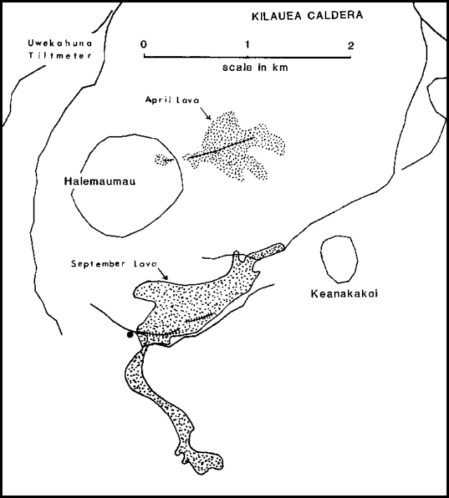
Was the September 1982 eruption comparable to the current one? It was like an episode of the current eruption. The location was on the southern caldera rim, so similar to the position of the current eruption in the western caldera rim.
https://volcano.si.edu/volcano.cfm?vn=332010#bgvn_198209
 ?itok=5pKd6Dgg
“General fountain height was estimated at 20-40 m, with Strombolian bursts that occasionally went as high as 50-70 m. Lava, fed primarily by these vents, rapidly filled a broad graben. At about 1930 the lava spilled southward through a gap in the caldera wall and fed an actively flowing channel that eventually extended more than 1.5 km to the S”
Apart from being in the summit, not really. The only summit eruption like this one was 1959 but even that has diverged, only E1-E2 which had drainback were like that really.
The best way to think of this, is as a somma volcano, or like Pu’u O’o. Its not comparable to any other caldera eruptions historically, except kind of to 1959 as earlier.
The 9/1982 eruption was like the 7/1974, Kilauea Iki and the current eruption on the caldera rim or outside the caldera. Are they ring fault eruptions? They look somewhat different to intra-caldera eruptions (f.e. Halema’uma’u or eruptions in Kaluapele)
HVO says that the last explosive period of Kilauea began with a phase of tall lava fountains up to 600m high: “Towering lava fountains, likely more than 600 m (2,000 ft) high, roared from Kīlauea caldera just after it formed and began 300 years of explosive eruptions that ended in the early 19th century. … This eruptive period blanketed the summit area with an 11-m- (35-ft-) thick deposit known as the Keanakāko‘i tephra.”
Do tall lava fountains usually precede an explosive period like this or a shield building period (f.e. Observatory Shield)?
https://www-vedur-is.translate.goog/um-vi/frettir/landris-heldur-afram-i-svartsengi?_x_tr_sl=auto&_x_tr_tl=en&_x_tr_hl=en-US&_x_tr_pto=wapp
“If magma accumulation continues, the likelihood of a magma flow or eruption could increase in the fall.”
I’m fixated on Ljósufjöll. It probably won’t erupt in my lifetime, but it fascinates me to watch this “new” development. No landris – yet! Quakes at 20 – 18km and a few at 5 – 1km.
https://en.wikipedia.org/wiki/Lj%C3%B3sufj%C3%B6ll – Ljósufjöll
https://en.vedur.is/about-imo/news/seismic-activity-in-grjotarvatn-has-increased-in-the-last-months
i believe ur chances may be better than u think; fagra produced its first eruption within a couple years from the first signs of unrest…given reykjanes has far larger magma supply, but my personnel guess is that Ljósufjöll will take less than a decade until we see lava
I think that it’s very unpredictable now. 2020 we didn’t know that Fagradalsfjall was going to start one year later. There were swarms around Thorbjörn, so it seemed possible that there could happen something.
But it seems that the western volcanism in Iceland is more active at the same time. Eruptions of Ljosufjöll or WVZ sytems are more likely during Reykjanes Fires than during other times.
My nagging fixation is Daisen volcano. It’s not monitored by the JMA but its latest confirmed activity is ~18000 years BP. What’s more, there exists a claim (from 2012) that deposits from ~3000 years BP have been discovered, but to my knowledge there haven’t been any follow-ups confirming or denying that find.
Its known activity largely coincided with activity at the nearby Sanbe volcano, which has had multiple Holocene eruptions, including at ~4000 and ~1400 years BP. Given that both Daisen and Sanbe appear to be supplied in similar ways, ~3000 years BP fits snugly into that timeline. The catch, of course, is if Daisen got cut off somehow. I recall reading about low-velocity zones underneath it, so I suspect it still has access to magma.
Given its past record of powerful eruptions, I would think people would be more interested in ascertaining whether or not it’s had Holocene activity!
“50,000 years ago, this mountain had a plinian eruption from which volcanic ash can be found as far away as the Tohoku Region of Japan.” en wiki, Mount Daisen
This corresponds to ~ 1.000 km. Would that be a VEI4 or lower 5?
If yes the problem is visible as after that comes the ocean. So I think it is very difficult to prove bigger eruptions in the area long ago as ashes would disappear in the oceans and on flat islands.
Paektu/Changbai seems easier to me. Also close to the ocean, but last eruption a mere ~ 1000 years ago and well preserved caldera with lake.
Hoping this link shows up, but this is my source for the handful of VEI 5-6 eruptions in Daisen’s past: https://vogripa.org/searchVOGRIPA.cfc?method=detail&id=1146
The quote from the alleged Holocene tephra discovery (translated from Japanese):
In this study, the authors found a silty sandy volcanic ash layer more than 1 m thick at the southern foot of the volcano, near the Mizukue area (site 1). This volcanic ash layer contains carbonized wood chips and is likely to be a pyroclastic flow or pyroclastic surge. A 5 cm-thick layer of volcanic ash was also found in the surface layer of black ash near Kagamiganaru in the eastern part of the site (Site 2). A piece of carbonized wood at Site 1 yielded a 3110 ± 60 BP 14C age, while the soil immediately below the volcanic ash layer at Site 2 yielded a 3290 ± 40 BP 14C age. The ages are in close agreement with each other, suggesting that the tephra is pyroclastic flow and its fallout tephra. The source of this pyroclastic material is likely to be in the area between Karasugasen and Misen based on the distribution of pyroclastic flow topography.
The article mentions uplift below (and preceding) the edifice and extrusion onto the edifice, but seems to have left out perhaps the primary contribution to the bulk of the edifice itself: intrusions that cool and solidify within the edifice, without necessarily any portion even having erupted.
It is in the post, but not in any detail: “The initial rise of a volcano precedes any eruption. It rises because magma accumulates below the surface”. It is implicit in the Mogi model. Once in place, if it cools then in principle there will be deflation and this is seen in quiescent volcanoes.
The limits on volcanic surface structures are interesting but what do you reckon the upper limit on what lies beneath the surface? What do you think is the limit on how much magma can accumulate in reservoirs?
Probably the point where the crust above would founder, which is probably about the size of the big calderas, variable size depending on the crust.
If batholiths count then that is probably the biggest crustal storage. The batholiths in the Andes feed many volcanoes, those in the Himalayas not so much though. Not sure if there are any other locations of this scale right now, other crust is too thin. And most of the batholith will never get close to erupting, so hard to say.
I guess too, how far down is too far? Hawaii starts at the core mantle boundary, so do many other plumes presumably. Nothing else is even slightly comparable to a core plume in size. Its also now known the actual magma systems in Hawaii are extensive too, 150-200 km of rift zones, and 50+ vertical extent. I guess it makes sense that very big nd productive locations have big magma systems. Iceland could have similar extent, possibly also too the EAR volcanoes, though none are as productive individually.
That is an interesting question. It depends on depth and melt fraction, of course. A big limitation is the strength of the crust. A large magma chamber will begin to heat and weaken the roof of the chamber and this can lead to catastrophic failure. For a strong crust and large chamber in an area with extension (so less stress), the magma chamber can grow very large before failure. This is one way to create a super eruption.
There is no real limit to magma accumulation below the crust, I think.
@albert, I would assume extension would do the opposite – weakening the overlying crust, not the other way around?
For a long time, I have had a bit of a working mental model for how large silicic caldera flareups form in regions where there is active crustal extension / thinning.
The process goes sequentially like this:
1. Large amounts of magma form batholiths or large deep laccoliths. These deep and very large magma chambers wouldn’t *normally* erupt due to being too deep in the crust. They would typically act as magma feeders for overlying volcanic systems, but wouldn’t be a risk of caldera formation due to the strength of the overlying lid.
2. The large, deep magma chambers are long-lived, and eventually assimilate crustal rock and fractionate, creating significant amounts of rhyolite / highly viscous magma. Much of this would likely be somewhat uneruptible crystal-mush at this stage.
3. Eventually, crustal thinning starts to take place in the overlying rock. This is not all that uncommon in volcanic arcs, and is thought to be related to slab gaps, slab steepening, or other subduction / tectonically related activities. Obviously in a full-on rift zone during continental breakups, you would get this as well.
4. The crust gradually over millenia thins significantly enough that the once-deep large plutons / batholiths are no longer so deep. This starts to potentially expose large magma chambers that would never have been able to accumulate such a large size in the shallow crust to risk of a rupture.
5. The decompression of the overlying crust along with any still-ongoing magmatic intrusions rejuvenate and reactivate crystallized rhyolite, causing it to re-melt, and mix. This creates large quantities of eruption-ready magma.
6. Some event occurs that weakens the overlying crust. Typically, this would just be a standard eruption, but if there is enough weakness created when the eruption breaks through to the surface, this can set off a chain reaction, resulting in most of the now-exposed batholith to erupt. And voila, you get a super-eruption and a large caldera.
To me, this mental model makes a lot of sense based on what we know about silicic flareups and even existing regions of the world where you see clusters of large caldera systems. that being said, this clearly would not be the only way you would get large caldera eruptions.
Extension means that the magma chamber can grow larger because of less stress. Toba is an example, where the bend in the fault causes some extension. Taupo is another one. This is for VEI-8. A VEI-7 is a different beast which requires different conditions
I’d suspect the best way to get massive magma accumulation is through a strong hotspot over continental crust, akin to Yellowstone. Yellowstone hotspot is waning but it’s been linked to the La Garita eruption if I am not mistaken which would be considered a VEI 9 in bulk. It’s unfortunate(or extremely fortunate) that we’ll never have such a setup and there doesn’t look to be similar case for millions of years.
Kirishima (Kyūshū island) disrupts air traffic with an ash plume to 7300m: https://www.vulkane.net/blogmobil/kirishima-flugausfaelle-durch-vulkanausbruch-am-shinmoe-dake/?fbclid=IwY2xjawLTIRJleHRuA2FlbQIxMQBicmlkETB1ZFEzVzZUbzNBTjJWeElmAR69tAD4EV6x3sZCkPhrTviYXYlwpz8bCcxnyRHV-3Ya7picwIMY9757nhXoVA_aem_BHH6zap-Kru8EclX2-Dp6Q
There are many quakes in the Ryukyu islands area now: https://www.volcanodiscovery.com/earthquakes/japan.html
Yes, the Tokara Islands frequently get these seismic swarms. I don’t know the cause, however.
Is there someone with a seismology background that can explain it? Would be much appreciated.
No such background – would always accept to be corrected – would suggest however that the reason is the Ryukyu Trench, maximum depth 7.460 m and that subduction is not always a quiet process.
The Philippine Plate subducts under the Eurasion plate at an angle, next north comes the Nankai Trough. It would be more surprising if there were no quakes.
Biggest quake in the area:
https://en.wikipedia.org/wiki/1968_Hy%C5%ABga-nada_earthquake
7.5, plus tsunami
Adding to this are several faults plus uplift.
https://www.researchgate.net/figure/Tectonic-framework-of-the-East-China-Sea-area-and-the-seismic-cross-sections-used-in-this_fig1_271995101
Thanks. A bit surprised that it’s one of the usual suspects considering the swarm-like nature. Wouldn’t have thought of linking the Tokara Islands with the Hyuga-Nada thrust (which has been quite angry itself over the past year).
The JMA has this annoying habit of only publishing detailed reports on the most notable earthquakes, so moderate events like the Tokara quakes receive little more than epicenter reports and tsunami advisories.
This popped into my inbox just yesterday
Which gives a pretty good analysis of the Ryukyu tremor swarm
https://earthquakeinsights.substack.com/p/earthquake-swarm-rattles-the-japanese
Link didnae work
should get you somewhere near in a search bar. Top notch earthquake analysis site
Good shout on the website, I haven’t seen that one before. Thank you.
The current earthquake series/swarm (with up to Magnitude 5) occurs close to Akusekijima volcano.
https://www.volcanodiscovery.com/akuseki-jima.html
The volcano didn’t have any historical eruptions. It has – according to Wikipedia – Andesite to Dacite magma. The current earthquake activity is 20km away from this volcano. Can there happen a birth of a new volcano? In this subduction zone a Surtseyan eruption would use an evolved magma, maybe Andesite.
Is there also a bottom line about how much a mass can sink? The mantle itself is not liquid, but nearly solid. Can it resist to a certain point, so that something doesn’t sink further than level x?
I imagine f.e. an accumulation of the Hawaii Hotspot on a stationary oceanic plate. If we accumulate all the pre-Big Island “lava mountains” until Kamtchatka on Big Island, we get a crazy huge mass that would test, how much it can sink, until the mantle resists too much.
It would sink until neutral buoyancy. Icebergs are 90% underwater because hexagonal and amorphous ice found naturally in Earth surface conditions are 90% the density of liquid water. Same is true for all liquids and solids, its especially true for anything floating in mercury, for an obvious visual.
Basalt has an upper density of about 3 g/cm3, its usually less in samples but it probably has max compression and minimal or no voids in a big island so upper limit is more likely more than 1 km down I guess. The asthenosphere has a density of 3.3 g/cm3 so more but not much. Difference is 10-11% more, so I guess islands like Hawaii are about as buoyant in the mantle as ice in water, so would sink until 90% of the lava pile is below the seafloor elevation. This ignores the ocean and crustal strength though so it would be less in reality but fairly close.
This is called subduction. Cold ocean crust becomes denser than the mantle. It sinks to 400 km. Below that the mantle is denser and only some crust is dense enough to sink further. Others hang around at this depth. This that sink further can reach the bottom of the mantle.
Island crust is a bit less dense than pure ocean crust and will not sink so easily. In subduction zones, the island arcs are scraped off and may become plastered to any continental crust. This is probably how continental crust first started.
If we imagine that 10 times of Big Island have accumulated over each other, how deep would it sink compared to the single Big Island? Would the peak mountains still be like Mauna Loa / Mauna Kea around 4-5km high or could they grow higher above sea level?
How high is the density of such a “super” volcanic mass compared to the Himalaya orogency? I’d tend to believe that soft basaltic lava/tephra or Gabbro is less dense than hard Gneiss/Granite rock in the core parts of mountain chains.
I linked this upthread:
Hawaiian Trough (wiki)
It’s quite deep. As the wiki goes on to say it now has 2 km of accumulated sediment deposited in it.
Means since it last had summit overflows, Kilauea has become 15 meters lower. But its likely to grow far more than that soon.
If the trough is 2 km deep Hawaii would be 2000 metres taller if the ocean crust hadn’t sank around it. Which would make Mauna Kea the third highest mountain in the world. And that’s just the bit which is above sea level.
yes BUT’:
1) There is buoyancy from the sea which will result in more depression. Lower height.
2) The buoyancy from the sea also supports the edifice structure which otherwise would partially collapse under its increased weight, reducing the height.
3) IMHO height above sea level is a perfectly valid and universal definition of height.
4) Those wishing to big up Hawaii (which is not really needed) might like some other measure which might combine slope and distance but its pretty arbitrary.
5) Will americans please note (although it’s way too late for a change) that a buoy (a floating marker found at sea) is pronounced as buoyancy and not booey. .
I thought that the plume with the upward force counter-balances the force of weight. When islands leave the Hawaii Hotspot they sink towards and below sea level. Midway Atoll is an example for this: https://en.wikipedia.org/wiki/Midway_Atoll
The volcanic part of this island (one of a former “Big Island”) is already drowned below sea level. Only the biological sediments (Limestone, Coral Reef) save the island. Midway was volcanically active 28 million years ago
The seafloor around Kilauea is depressed about 200 m below the Pacific floor (similar to a 150 m deep shorebreak on Mauna Loa’s SWRZ), though in truth the moat is a bit deeper since parts of it are filled with sediment. Next to Hilo, there is an old coast, sunk 1 kilometer underwater, which is thought to be the tip of Kohala’s ERZ (about 500,000 years old, I think), now mostly buried under Mauna Kea. The crust subsides due to the weight of the volcanoes, and since the Big Island started to form around 1.1 Ma ago it has likely subsided up to 2 km in the north of the island and 1-2 km in the center. Haleakala’s subsidence bowl is likely deeper and I’m pretty sure it must exceed 3 km, maybe 4 km even.
How much does the plume push the crust upwards at the same time? Hawaii’s islands don’t shrink only by erosion and apocalyptic collapses, but also by subduction after they leave the hot plume area.
Actually, it looks like I greatly underestimated the subsidence, a 2023 tomography article puts the crust subsidence between Kohala and Haleakala at 7 km. So Haleakala is 14 km tall!
https://agupubs.onlinelibrary.wiley.com/doi/10.1029/2023JB028118
Haleakala is already on the border of the plume. So the subduction should increase there, because the heaving effect of the plume is decreasing.
After leaving the plume, both Mauna Kea and Mauna Loa will supposedly sink below sea level, probably at least 5km … and additional effects by erosion/collapses.
Did Haleakala host a larger volcano than Big Island so that the volcanic mass is thicker there with 14km?
Yes, Haleakala is probably larger than the Big Island volcanoes. It covered an area of 6,500 km2 above water at maximum extent, which is more than the 5,000 km2 subaerial Mauna Loa spans at present (and Mauna Loa likely got a lot of help by covering Hualalai’s south rift which may very well reach Ka Lae). Haleakala is also notable because its East Rift Zone attained 150 km length, the longest for any individual rift since the Saint Rogatien Back (which is roughly the same). Pūhāhonu (14 Ma) may be bigger than Haleakala, though.
Volcanophil, there is no subduction around Hawaii. I suppose you wanted to say subsidence, right?
Mauna Loa has 9 km of subsidence though?
Yes, I wanted to write “subsidence” …
How much subsidence was there at Midway Atoll? It must still be more kilometers down than Haleakala, although the volcanic island was probably less voluminous.
“How much subsidence was there at Midway Atoll?”
Not much, some hundreds of meters maybe. The map below is a gravity anomaly map (how much gravity would deviate from average at sea level, if I’m not mistaken). The moat around the islands has a lower elevation and is filled with low-density sediments, so it shows a low gravity anomaly. The moat comes and goes depending on how strong the Hawaii hotspot was at the time, because the moat is deeper the bigger the volcanoes are, their weight pushes down the lithosphere. There was even an interval, 42-32 million years ago if I’m not mistaken, when the moat disappeared completely. At the time, the Hawaii hotspot faded so much that seamounts wouldn’t even breach the water surface.
“Mauna Loa has 9 km of subsidence though?”
The latest estimate is the one from the image below, which puts the amount of subsidence under Mauna Loa at 7 km, and even that may be generous, I think. The coastlines of East Molokai (1.8-1.6 Ma?), 70 km away from Haleakala, had subsided over 1 km by the time Haleakala reached the end of its late-shield; much of this subsidence must have been the result of Haleakala’s growth and centered under its summit. This is similar to how similarly distant coastlines of Kohala from Mauna Loa have subsided 1 km over the past 500,000 years. However, Haleakala’s southern late shield coasts (1 Ma) underwent an additional 2 km of subsidence, likely as a result of its weight and the construction of Kohala volcano to the south. So I believe that subsidence under Haleakala must be some 2 km more than Mauna Loa. Another way to look at it is the decollement earthquakes that happen under Mauna Loa’s flank, presumably along the ancient ocean floor. The 1983 Kaoiki quake, for example, was 9 km deep bsl, so that would point to a 4 km subsidence below the typical Pacific ocean floor, which is much less than usually assumed. Normally, it is considered that because Mauna Loa is taller than other volcanoes, there must be more subsidence underneath it, but it may just be that the lithosphere has yet to adapt to the Mauna’s recently acquired height.
Hector,
“42-32 million years ago if I’m not mistaken, when the moat disappeared completely.”
That should be around the time of the curious kink in the chain, right? When the plate changed the direction, supposedly.
That’s right, Denaliwatch, it was at the time of the kink in the chain.
???
what place is this?
Probably Chiles-Cerro Negro, given Rockwell’s general pattern of interest.
Alert level at Aso has been raised:
https://www.jma.go.jp/jma/press/2507/04a/20250704_asosan.pdf
Aso erupt on average VEI2, sometimes VEI3 or VEI1. An example for frequently active, but moderately strong erupting volcanoes. According to GVP typical eruptions include “periodic strombolian and phreatomagmatic activity”
Aso is mostly interesting; the knowledge of what it CAN do is terrifying. I was denied the chance to visit it when I was in Kumamoto, since the gases were evidently bad.
Kumamoto is a cool city, for the record. They’ve been through the seismological wringer though. Aso eruptions and major earthquakes, woof.
Pu’u O’o GPS deflates since the onset of the eruption in the summit. Is it rather linked to the summit eruption or to south flank movement?
Compared to this the summit tilt in January 1983, when Pu’u O’o began:
It’s hard to know what’s happening. Something is draining the Middle East Rift Zone magma storage; the summit eruption is definitely involved, but whether the magma from the MERZ is going to the summit or whether the summit is blocking supply and the MERZ is draining due to deep rifting is hard to know.
I wonder if the MERZ is draining, where is the magma going? It’s not just disappearing.
IMHO, if it is draining, it’s probably back into a shallow magma chamber (or sill) which is also feeding the summit vent…i.e. a common magma source for both. That there is time-sensitive linkage between the start of this summit eruption sequence and tilt changes in the MERZ suggests the two are hydraulically linked?
Another possibility is the MERZ is getting narrowed/closed off thus shutting down supply. If the MERZ and the summit vent are linked, then a closing off of the MERZ should increase pressure of the underlying magma source (kinda like sealing a leak in a pipe). This might explain why the recent fountaining has been showing an upward trend in height as pressure from below increases?
Or then again, I could be nowhere near the truth and my ignorance is showing in spades.
There are two places it can be draining to, the summit storage as you say, or the rift itself. Below 2 km, the rift zones of Kilauea are thought to be a sort of perpetual dike, that is molten or partly molten, and opens slowly as the flank moves southward. So it may just be that the deep rift is taking up more magma than the summit supplies (because the summit eruption has diverted the magma supply), in either situation, they are connected, though they are a mixture of melts with different compositions and densities and a complex balance influenced also by rifting.
Can the connection be a U-shaped pipe system, in which magma goes down from Pu’u O’o, moves west and comes up in the summit system?
1983 the summit lost in the opposite direction towards Pu’u O’o. There was no collapse, but significant and fast deflation (~130 Microrads). Magma went down here, moved east and came up at Napau and Pu’u O’o. Was 1983 an eruption like 2025 possible on the summit, if magma hadn’t moved to Pu’u O’o?
Part of it is the southward slide of the southern part of Hawai’i. That was compensated by new magma in the past but that has now stopped. As the slope slides south, the peak subsides. The second effect is that the magma that is still underneath is cooling and therefore contracting. That gives subsidence. There may be a third effect – but it may not be needed!
My interpretation was that magma isnt flowing out of the summit in any significant capacity, so the south flank sliding is causing extension and subsidence at Pu’u O’o. Probably just background movement of the island sliding.
I dont think it is really magma movement so much, its pretty visible that when magma does move in the uplift and deformation is much faster than the background movement. There might have been magma backflowing in 2021, but it actually only started deflating at Pu’u O’o in late 2021, when the SWRZ flared up briefly, and it was already going down a month later when the second summit eruption happened.
At that point in time the summit vents were lower down than most of the ERZ too, but now it is not the case. The floor of Halemaumau is apparently on average 955m elevation or was a couple weeks back. The west side at the laser is 986m though, and the vents themselves are well over 1000, possibly 1050 meters and rising fast each episode. Thats as much as 300 meters above Napau, and close to the pre-2018 lake elevation which will likely be surpassed within 2 months.
The southward slide as a factor was one possibility. The GPS station shows a linear S-movement until August 2024 and since December 2024 (interrupted by ERZ activity on Napau).
How high were the Siberian traps, when they occured? How well could the Pangea continent resist to subsidence?
https://www.annualreviews.org/content/journals/10.1146/annurev-earth-040722-105544
The Siberian traps ” generated an estimated 7–15 million km3 of intrusive and extrusive igneous rock”, they were probably the “most voluminous Phanerozoic continental LIP.” (Phanerozoic age includes the whole geological history from Kambrium to Holocene).
It happened during late Permian period 252 million years ago and lasted for one million years.
Siberian traps
Surely most has been eroded away, the original volcanic system must have been immense.
Yes. The Deccan Traps, considerably younger, still have a height of ~2000 m.
Compared to the UK’s volcanism (~50 million years) the Siberian traps are indeed 5 times older (~250 milion years) with a simplyfied calculation. We don’t see much of the actual UK volcanoes, only the remaining bases. This shows the speed of erosion, and Siberia had 5 times more time to make the landscape flat.
The present Asian continent would probably be able to bear the Hawaii Hotspot better than the Oceanic plate. Can we imagine how the Hawaii Hotspot in Siberia would look like?
The UK volcanics was a rifting event. The volcanoes were therefore always next to the ocean, and presumably in a rainy climate. That means fast erosion. The Siberian traps were in the middle of a continent, further from the ocean (although the southern area was closer to the Tethys). The flood basalts are also much flatter than the volcanic peaks of the UK. So one may assume lower erosion rates. The flood basalt of Swaziland is still kilometres thick but it has disappeared in other places. Erosion doesn’t affect every place in the same way.
Looking at the geological map, I got the impression that the western side, which seems to have contained the source structures (so might have been higher) is significantly more eroded than the eastern lava field. Anyone like to comment?
We have decent subduction-related volcanoes in Kamtchatka. So why the heck do you want to transplant that hotspot to Siberia? This leaves me speechless.
Good enough:
One could argue that it would actually be nice to move the hot spot to a place we can actually visit.
North Sea north of Scotland would be nice 😊
On the other hand we could ask why the Azores Mantle Plume is not as active or, alternatively, whether Hawaii is the only mantleplume in the world (at the moment).
I think that Steens Mountain is a pretty decent example, a shield volcano with stacked basalts on the Eastern face, Steens is part of the Columbia River Basalt Group, late Miocene. It is high, but not extraordinarily high. Those basalts are about 1 km thick. As Albert says flood basalts do not become too high, but instead very large what leads to the name.
Steens:
Restoration of Miocene animals at Picture Gorge Basalts:
source wikipedia, CRB
Finally another interferogram of Kilauea, after the last few weeks being blank. It only covers E27 over the past few days, but even just that is enough to see the depth of tephra falling on the rim.
http://www.mounts-project.com/static/data_mounts/kilauea10/2025/kilauea10_20250627T161633_20250703T161532_VV_ifg.png
The last few episodes seem to show a slow trend too, the episodes are getting larger, more voluminous, but the intervals between are not increasing as consistently. E28 is due in 2-3 days, after about 1 week, even though the volume is twice as much as episodes a few months ago that had similar intervals.
Where was 1919 the exit point in the Caldera towards SWRZ? Maybe the present eruption seeks the same direction on the surface, where 1919 magma flowed some 100m deeper. Is there a map with the 1919 cracks?
Pretty much along the bottom edge of the E27 tephra pile in the image. Its still possibly too high up to drain that way for a while though, maybe next year.
I think this is an interesting read, some basics:
https://edition.cnn.com/2025/07/05/weather/aphelion-sun-summer-heat-climate
It misses the main point. The effect is opposite in the southern hemisphere, and because 7% of summer sun is more than 7% of winter sun, the south ends up with more solar radiation over the year. That difference is an important driver of our climate. (But not in the US which apparently doesn’t have climate anymore.)
I expected s.th. like this. Thank you.
Another interesting thing I saw – close to our topic here – is this:
https://en.wikipedia.org/wiki/Ajanta_Caves
I was wondering whether this was built right into the Deccan Traps. And it lookslike it, map:
Inside, beautiful, study pics:
Let me consider this also a shrine for the dinosaurs then.
Yes, humans have an urge to cut voids into any suitable rock everywhere.
From india, turkey and arabia. Must be some in china, too.
They are all pretty cool though.
Plus American Indians. Mesa Verde NP for example.
Humanoids clearly became cave dwellers after leaving the trees. There is safety in walls
Mesa verde…
I cannot think why I omitted this, having been there. An amazing site with added climbs up lashed ladders and guided tours round sites that in the UK would be covered in H&S safety railings, totally ruining it.
In retrospect, though, not actually cut into the rockface.
For a real experience of stone age cave use (existing) all should visit
https://en.wikipedia.org/wiki/Actun_Tunichil_Muknal
before tourism destroys it. A magical experience.
I loved the Gila Cliff Dwellings, further south. It is build into caves on the cliff face
“Was Mars doomed to be a desert? Study proposes new explanation”:
https://news.uchicago.edu/story/was-mars-doomed-be-desert-study-proposes-new-explanation
The main paper: “Carbonate formation and fluctuating habitability on Mars”:
https://www.nature.com/articles/s41586-025-09161-1
Tl; Dr: Because not enough … (you guessed it!): volcanic activity (CO2 outgassing) on Mars.
Mars small size doomed its geological carbon – sillicate cycle its internal heat its not powerful enough to runn that cycle effectively and results with Mars ending up with a permanent snowball state that it cannot escape from.
If Mars was a Super Earth 2 to 4 Earth masses ( powerful internal heating ) it woud sourely be a verv divergent living world compared to todays Mars. Super Earths are tought to be even better than Earth is at the carbon – sillicate recycling
If Mars and Venus could be switched it might be very interesting. Venus’s atmosphere would make up for the extra distance from the Sun and Mars’s small size and thinner atmosphere would offset the greater solar irradiance. Might then be permanent liquid water oceans on both planets. In theory both are in the habitability zone, albeit on the edges of it.
It depends if the atmosphere freezes or not. Perhaps two stable states, too?
It woud not work for neither of them.. in that scenario Venus atmosphere is too much Co2 and Mars is still too small for an active carbon – sillicate cycle
Yes but oceans and subduction can bury the CO2. Also you can dissolve a lot of CO2 in an ocean. I suspect too that Venus has a lot of CO2 due to the incessant volcanism – coupled with no biosphere to take it out of the atmosphere like happens here.
New post is up! Mount Shasta from beyond the grave.
https://www.volcanocafe.org/the-white-mountain-uytaahkoo-or-mount-shasta-2/