
The island of Vulcano (source: wikipedia)
The volcano helpfully called ‘Vulcano’, one of the islands, north of Sicilyhas give its name to all volcanoes in the world. Vulcano last eruption was in 1888-1890. During the long repose period, a settlement has grown from a few houses to villas and hotels. Frazzetta et al. wrote in 1984 (quoted by Boris Behncke)
“A volcanic hazard exists where there is the potential for loss of life or property as the direct result of volcanic activity. The major effects of all activity at Fossa are confined to within 2 km of the vent. The village of Porto with a population of about 250 inhabitants lies within this zone to the north of the main cone. During the summer the population of this town swells to more than 10,000. It is quite dangerous for a village to be located so close to an active volcano.”
The settled community has grown from 250 to 450 since 1984, and in August there may now be 12,000 tourists each day (Behncke, private communication). The location of this community so close to the crater has made Vulcano into the second most dangerous volcano in Italy, after only Vesuvius. And now the alert level has been raised to yellow. Luckily this is after the summer and the height of the tourist season. But we are concerned.
The following post is one from the archives. It was written by Henrik in 2013, and is well worth resurrecting. At the end, we also reproduce a description of past eruptions from the current crater, Fossa, based on an article by Boris Behncke and reproduced by permission.
Over to Henrik:

Fig 1. “The Thunderbolts of Zeus”. One of the amazing photographs taken by the incomparable Marco Fulle, often reproduced on the Internet without giving credit to this wonderful photographer.
Hephaistos, the lame son of Zeus and Hera, the King and Queen of the Hellenistic Pantheon, was the god of blacksmiths, artisans, craftsmen, metals, metallurgy, fire and volcanoes. He was also the weaponsmith of the Gods and crafted, amongst other things, the thunderbolts of Zeus.
Of course the Romans, the greatest copyright infringers ever produced by mankind incorporated the Greek Pantheon as their own religion and mythology. Here, Hephaistos was known as Vulcanus. The roman scholar Marcus Terentius Varro (116 – 27 BC) cites the Annales Maximus, which go back to at least 400 BC, as the source of the first mention of Vulcanus. He mentions that king Titus Tatius (d.748 BC) dedicated a series of altars to deities among which Vulcan is mentioned.
Perhaps more suggestive is the fact that a new eruptive centre formed in the strait between Vulcano and Lipari with the first recorded eruption occurring in 183 or 123 BC. The eruptions went on for more than a century, thus were contemporary with Varro, and formed a new island Vulcanello. This was volcanic creation of new land where only sea had been before and must have been considered by the ancient world as very significant proof of divine existence and omnipotence. In addition to its theological usefulness, Vulcano provided the Romans with wood, alum and sulphur, activities continued as the main produce of the island until the last, or rather, most recent series of eruptions of 1888-90 ruined the mining works. Today, Vulcano is home to some 500 year-round inhabitants while in the summer, the population grows to about 10,000. But not to worry, renewed activity will almost certainly be preceded by irrefutable signs of unrest well in advance of any potentially devastating event.
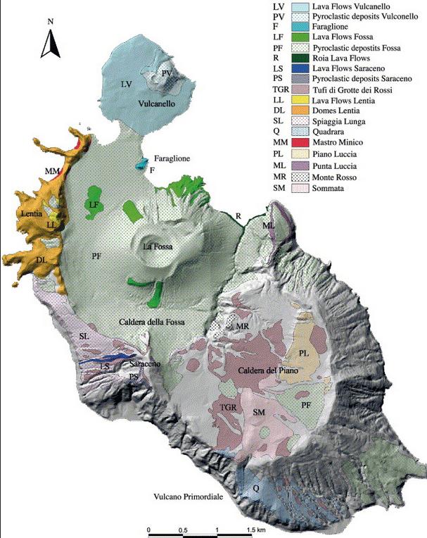
Fig 2. Geology of Vulcano (Gioncada, Mazzuoli, Bisson & Pareschi 2003)
The visual appearance of Vulcano is very suggestive with the most ancient centre of activity, the collapsed stratovolcano “South Vulcano” (ca. 120-98 kA) and Piano Caldera (ca. 98-97 kA) to the south, the Lentia Complex (15.5 kA) with the Lentia or Fossa Caldera (16 -13 kA) in which the new La Fossa cone (~6 to 5 kA) grew. To the NE of the Fossa cone an extrusion is obvious but no date has been given for it (14 kA Punta Roja lava flow?). Finally, to the north is the already mentioned Vulcanello complex (2.1 kA).
Activity at Vulcano began a mere 150,000 years ago and is divided into four major stages. The first, South Vulcano center, began at about 120 kA by building a trachybasaltic to trachyandesitic stratovolcano where pyroclastic fall and flow deposits constitute only a minor portion. The activity at South Vulcano came to an end with the collapse of the stratovolcano around 97 kA into the 2.5 km diameter Caldera del Piano. Interestingly, it seems that the caldera was formed, not by an eruption that led to a collapse but the collapse of the stratovolcano “for reasons unknown or unspecified”. Post-caldera activity continued for some 45,000 years which resulted in most of the caldera being filled by lava flows. Then there seems to have been a period of inactivity covering the next 30,000 years.
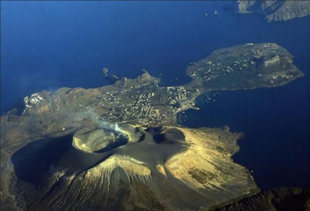
Fig 3. Looking north. An aerial photograph of the infilled Lentia Caldera with the Gran Cratere of the La Fossa Cone and island of Vulcanello
About 15½ thousand years ago, activity renewed at Quadrara and Spiaggia Lunga as well as the formation of the large rhyolitic to trachytic lava dome and flow complex of Lentia, the “Lentia Lava Dome Complex”, in the northwest. From somewhere in the strait between Vulcano and Lipari (proto-Vulcanello?) violent ash-flow forming eruptions occurred and deposited brown tuffs over a large area of the old Caldera del Piano to the south.
About 15-14 ka ago, another caldera collapse affected the island, this time in its northern part, forming the Lentia caldera. Again, there seems to have been no explosive eruption associated with the caldera collapse, which may have been “tectonically triggered”. Activity continued within the new caldera with at least five cycles of pyroclastic and lava flows, the most significant being the Punta Roja lava flow that crops out at the E base of the La Fossa cone. Eruptions also occurred from N-S trending fissures in the NW part of the older Piano caldera where the Alighieri formation and the edifice of Monte Saraceno were formed.

Fig 4. Inside the Gran Cratere of La Fossa (volcano.oregonstate.edu)
About 11,000 years ago, activity began to concentrate in the centre of the Lentia Caldera and at least four eruptive cycles formed the massive-looking albeit only 391 m high La Fossa cone. Over the past 2½ thousand years, there have been at least 15 confirmed eruptions with a further ten possible from La Fossa with the last terminating on March 22nd 1890.
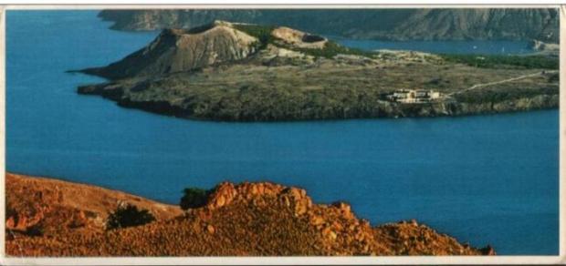
Fig 5. A post card of Vulcanello from Lipari
Although activity at La Fossa continues and cannot be said to be over, the last major eruptive period recognised is the already mentioned one that began in the second century BC and led to the formation of the Vulcanello Island and complex. Eruptive activity continued with at least two further eruptions after the initial, island forming series ended in ~10 AD. The final eruption, that of 1550, connected Vulcanello with Vulcano. The activity produced three overlapping tephra and scoria cones with craters shifting from E to W, and a gently sloping lava platform mainly on the N, W and S sides of the cone cluster. The Vulcanello products are generally more mafic than most other Vulcano eruptives, being of leucite-tephritic composition, only the most recent lava flow, Punta del Roveto of 1550 being trachytic.
HENRIK

Fossa, 2018. Source: Volcanodiscovery
Henrik ended his post with: For further reading, I highly recommend Dr Boris Behncke’s former site, thankfully saved for posterity by the Michigan Technological University
This site does not appear to exist any more. We reproduce here part of the content, describing the eruptive cycles of the Fossa cone over the past 6000 years. The text is slightly edited from the original. The images as shown here are available at https://slidetodoc.com/3-volcanoes-killers-and-creators-dr-daniel-barker/
The evolution of the Fossa cone, the most recently active volcanic center on Vulcano island, has been described in detail by Frazzetta et al. (1983) and briefly reviewed by Frazzetta et al. (1984) and Frazzetta & La Volpe (1991). The following is a summary from those sources.
The Fossa eruptive center developed only during the past 6000 years, after the presumably tectonically triggered formation of the Fossa caldera, about 14-16 ka ago. Its birth followed post-caldera effusive activity of which the 14 ka Punta Roja lava flow gives testimony. Activity of the Fossa cone has been divided into several cycles by Frazzetta et al. (1983, 1984) and Frazzetta & La Volpe (1991). The cycles have generally shown a characteristic succession of eruptive styles and each had an individual eruptive vent. Some cycles began with powerful vent-clearing explosions leading to deposition of “phreatic breccias” near the eruptive vents. The hydromagmatic initial stages of other cycles produced wet and/or dry surge deposits. Later products of each cycle show a decreasing influence of external water, the final products being fully magmatic (pumice-fall deposits or lava flows).
There is a complete lack of erosional surfaces and paleosoils between the products representing a cycle. It is assumed that activity during each cycle was more or less continuous. This contrasts with distinct erosional unconformities between the products of various cycles, evidence of longer repose periods separating different eruptive cycles.
Punte Nere cycle
The initial activity of this first recognized Fossa eruptive cycle was hydromagmatic and produced a more than 60 m thick sheet of dry surge deposits overlying the Punta Roia lava flows (14±6 ka). The basal strata of this sheet are composed of coarse and fine clasts and are overlain by sandwave and massive beds. Fragments of a trachytic lava flow that may have been ruptured by the eruptions and a thick block-fall deposit are present in the middle part of the sequence. A fall deposit composed of normally bedded and occasional reversely bedded layers with interbedded surge beds make up the uppermost pyroclastic unit of the cycle. It was followed by the emplacement of the trachytic Punte Nere lava flow that forms a delta-like feature on the N base of the Fossa cone. This flow was dated at 5400±1300 years.
Frazzetta & La Volpe (1991) estimate the volume of tephra produced during the Punta Nere cycle at 195 x 106 m3 and that of lava at about 3 x 10⁶ m3. The activity left a cone about 250 m high. The NE crater rim is still well discernible in the eastern part of the Fossa cone.
At least three undefined eruptive cycles occurred after the Punta Nere cycle and left wet and dry surge deposits as well as the Campo Sportivo lava flow (see the map of lava flows), on the NW base of the Fossa cone. That flow has a radiometric age of 4600±1700 years and thus falls into the same time window as the Punta Nere flow; stratigraphically, though, it lies in a higher position. The volume of the Campo Sportivo lava flow is 2.6 x 10⁶ m3 while that of the tephra presumably associated with it is 25 x 106 m3. The volume of tephra from the other undefined cycles is about 10 x 106 m3.
Palizzi cycle
Following a repose period of unknown duration, hydromagmatic activity led to the emplacement of wet surge deposits followed by dry surge beds. Accretionary lapilli in these initial deposits give testimony of a high water component during the opening stage of the cycle. Later activity produced a stratified, normally graded pumice horizon which shows evidence of a brief erosional interval at its top. When activity resumed, it was again hydromagmatic and deposited another set of basal wet and overlying dry surge horizons.
Like during the preceding cycle, the late stage activity was effusive, producing about 0.6 x 10^6 m^3 of trachytic lava that forms a narrow tongue on the southern flank of the Fossa cone (Palizzi lava flow, see the map of lava flows). The volume of all tephra emitted during the Palizzi cycle is given as 5 x 10⁶ m3. The age of the Palizzi lava flow is 1600±1000 years. This is well within the historic period but no correlation of the deposits with recorded historic eruptions of Vulcano is possible.
Comenda cycle
This cycle began with powerful explosive activity of which a basal breccia gives testimony. The breccia is composed of yellow hydrothermally altered clasts and is overlain by a pyroclastic flow unit with numerous fumarolic degassing pipes. The activity then shifted to hydromagmatic and produced wet and then dry surge deposits with abundant Pele’s hair (!) before it became again magmatic with the extrusion of the Comenda obsidian lava flow that is still partially visible on the SW flank of Fossa cone (see the map of lava flows). Its volume is 2.6 x 10⁶ m3, slightly more than one tenth of the tephra volume (25 x 106 m3).
Frazzetta et al. (1983) assumed that the upper and larger of the two Forgia Vecchia (“Old Forge”) craters was formed during the Comenda eruptive cycle. These craters are well distinguishable on the two photos below of the 1888-1890 eruption but have been subjected to intense erosion since then and are densely vegetated.
The initial activity (breccia and pyroclastic flow) probably occurred before the mid 6th century AD since these deposits are overlain by the white ash from the most recent explosive eruption of Monte Pilato, Lipari that is thought to have occurred around AD 550. The Pilato ash is overlain by the wet and dry surge deposits. Historic documents indicate that the emplacement of the Comenda lava flow may correspond to an eruption recorded for the year AD 785.
Pietre Cotte cycle
Initial activity was hydromagmatic, producing wet surge and soon after, dry surge deposits. A pyroclastic fall sequence (described as “pumice” by Frazzetta and La Volpe 1991) rests on top of these early products. The exact timing of the eruption’s beginning is not known but it is probable that one of its more peculiar events, the formation of the lateral Forgia Vecchia II crater (on the NW rim of Forgia Vecchia I crater), occurred in 1727. Twelve years later, lava seems to have filled the main Fossa crater and spilled over its low N rim, forming the obsidian lava tongue of Pietre Cotte (“Cooked Stones”) that is still conspicuous on the steep northern slope of the Fossa cone (see the map of lava flows). Its volume is 2.4 x 10⁶ m3.
Unlike other cycles, the Pietre Cotte cycle apparently did not end with the lava outflow. Following the effusive activity, eruptions resumed in 1771 and continued intermittently until 1890. All activity before the latest major eruptive episode, in 1888-1890, is not well documented whereas very detailed scientific descriptions of the most recent activity are available (see below).
1888-1890 eruption
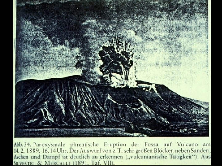
Photo of Vulcano in eruption, 14 February 1889. This view is of an explosion that ejects large bombs or blocks above a steam and ash plume. This photo was originally published in Mercalli & Silvestri (1891) and shows evidence of slight editing.
Vulcano last erupted in 1888-1890. Although it had erupted frequently in historic times, this eruption was the only one that was observed by scientists and was described in detail (Mercalli & Silvestri 1891). The activity observed by them was used for the introduction of a new scientific term, the so-called “Vulcanian” style of volcanic activity, now applied for powerful magmatic activity somewhere transitional between Strombolian and sub-Plinian.
The eruption was particular for the ejection of countless large breadcrust bombs. Meter-sized bombs fell in the area now occupied by the village of Vulcano Porto, on the crater rim they are much larger.
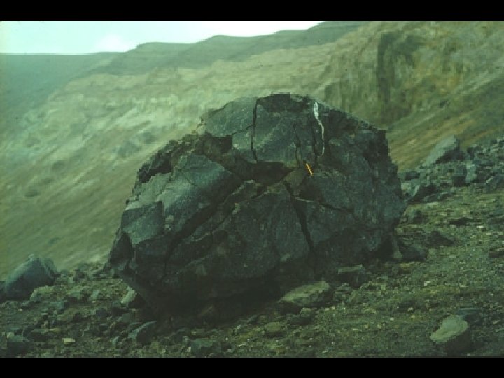
This is the largest of the famous breadcrust bombs ejected during the 1888-1890 eruption from Fosa Grande (the crater visible in the background). Giada Giuntoli is the person who gives scale. This bomb didn’t make it far away from the crater, but smaller ones fell abundantly in the area now occupied by the village of Vulcano Porto. 18 April 1995.
The buildings of the sulfur mining company located at Porto Levante were heavily damaged by falling tephra already during the first days of the eruption (starting on 3 August 1888), their residents could escape without fatalities or injuries. Later eruptions caused occasional ash and rare lapilli falls at Lipari. No major damage was done there, but the area now occupied by the village of Vulcano Porto was subjected to heavy bomb and lapilli showers.
The eruption ended on 22 March 1890, after gradually declining for several days. There were repeated unconfirmed reports about eruptive unrest at or near Vulcano, but no significant eruptive activity took place after 22 March 1890.
With the 1888-1890 eruption, the Pietre Cotte cycle seems to have come to a close. The volume of tephra produced during the entire cycle is given by Frazzetta & La Volpe as 25 x 106 m3 of which the 1888-1890 products do not make up more than one fourth.


Thanks for a superb article Henrik.
Love the lightning photo.
I am afraid Henrik died two years ago. He was with VC for many years and wrote some of our best articles
perhaps we can still ‘Thank Henrik’…. we don’t know everything… we believe a lot but don’t know everything.
We don’t know everything. But we need memorials, and VC is one for him
This is a great article on Vulcano. My thanks to Heinrik for writing it, and to Albert for bringing it back.
The current increase in fumerolic activity is troubling, though I’d really like to know if such variances in the emissive volume have occurred before.
I very much agree with those saying that the worst scenario is a little-to-no warning violent eruption.
I doubt that can happen. If it’s been dormant for almost 150 years it will necessarily be rather noisy when redeveloping a usable conduit.
edited – admin
What the hell happened to my previous comment?
Part of it fell victim to a hungry dragon enforcing editorial policy
That can’t be the case, because I didn’t violate editorial policy.
i miss Henrik kinda nice to ‘visit’ with him again. and i do hope the people on Vulcan stay safe! We have enough vocanoes going now….. it can just hold off! Thanks, Albert.
48 quakes on La Palma since midnight, some deep, but most around 8-11 km depth. Island is restless. http://www.ign.es/web/resources/volcanologia/tproximos/canarias.html#
posted few minutes ago in the last article comments, yesterday drone view of Vulcano:
Yikes… is Vulcano capable of a 4? With Askja and Grimsvotn stirring in Iceland too, each of them are capable of 6s (whether they reach that is a matter for the event itself). Could be quite a tricky time for Europe they decide to go up…
Grimsvotn and Askja VEI 6? 1875 was a VEI 4, very powerful just a few hours long but DRE was 0.25 km3, caldera was a subsidence feature. Iceland doesn’t really do bigger than VEI 5, maybe on occasion but I think there has been some exaggerated expectations here in the past which don’t hold as well as they used to.
Vulcano looks like a place with only small eruptions but that is all you need really. Likely will be harmless but an unexpected eruption would be a disaster. It is really puzzling how such a known risk is taken, all the Italian volcanoes have millennia long observations but also people living right on the side anyway.
Iceland doesn’t do more than VEI 4? There has been around 7 VEI 5+s in the last 1100 years
Said it doesnt really do above VEI 5, there was Veidivotn but what we know about eruptions like this is that they last a long time, for 5 km3 DRE it could well have lasted a year at eruption rates similar to Holuhraun, or even several years if it was more intermitent, which is perhaps more likely, it was much less intense than Laki.
VEI 5s I am aware of in the historic period are Hekla in 1104 and possibly 1300 and 1510, and Oraefajokull in 1362. Snaefellsjokull and Oraefajokull are probably the two you want to follow, they are stratovolcanoes and tall, and one has proven itself. Hekla is not, I am trying to write an article on it.
I mean, 5 cubic km3 DRE is a VEI 6, if it isn’t then Pinatubo isn’t a VEI 6 either
Tephra volume is enough to qualify, but intensity was more like a VEI 3-4 that lasted a year basically, it was nothing like Pinatubo, or Novarupta, so I choose to make a distinction. Only Oraefajokull and Hekla in historical time are of that sort of similar magnitude and Hekla has since abandoned that way of life for the most part. Just like in Hawaii the VEI scale really doesnt work in Iceland.
This is why I dont like the VEI scale, or at least the way it has come to be used. It treats all numbers equal, so Holuhraun and Fagradalsfjall are the same, and Eyjafjallajokull erupted as big as Laki because they are both a VEI 4, we know both of those statements are completely incorrect.
What I am basically saying is a real comparison scale absolutely needs to take into account the type of eruption, and also the intensity of the eruption, not just he volume of the tephra it makes. Explosivity is here serving as an indicator for overall size of the eruption which is a nonexistant correlation.
Looks like Kilauea might be getting close to equilibrium, the lake is not rising much and the tilt is falling slower, like it is reaching a flatline. Fountains are lower and some are dead but maybe that is more the depth of the lake than anything else, the vent on the edge of the lake is still the same as yesterday.
Really who knows but I think this time around the lake might evolve into a permanent feature. Vents opened under it and are clearly still active, and with so much heat both below and now above the rock under the lake must be pretty weak. Pretty good chance this lake evolves into an open conduit, and the lava surface just rises up over time, until something else breaks somewhere. Open conduits mean probably no gigantic fountains though, not until caldera collapse, but perhaps those of us who missed out on Pu’u O’o and cant afford a trip to Iceland will get their lava fix anyway 🙂
I don’t know how much fumarolic activity is typical there but I believe this is much more than usual. Certainly ominous looking. I will never understand why humans choose to build settlements in such places. As Geo Lurking is famous to say.. don’t be there.
Look at Vesuvius, big nasty volcano. Yet it hasn’t erupted properly in 400 years, yes it had a relatively small eruption in 1944. The volcanic soils are extremely fertile, perfect for growing crops. Do you take your chances with a volcano that may erupt once or less a lifetime or do you find somewhere less productive for food? Our immediate concern will always be food.
But also remember, these days we don’t have to think too much about food production. We go to the supermarket and it is there waiting for us to buy, working the land on a horticultural level is a thing of the past for most people in the west.
So ‘the west’ imports all its food?
No, horticulture is important, particularly as its not really good to airlift green beans from kenya or peru.
Here in the UK, 80% of our food is imported, as is much of Europe. The main food exporters, such as the USA have vast swathes of farmland particularly in the midwest. Mass agricultural and industrialised production. Whereas in Europe when these places were first settled hundreds of years ago, there wasn’t the farming technology as there is now, hence the conquests for fertile lands. Perhaps get killed by volcano that may erupt once in lifetime or less, or starve on yearly basis.
If the Grand Solar Minimum plays out the way Valentina Zharkova is expecting, we in the Northern hemisphere are going to become even more reliant on Kenya and Peru for food.
That is a big ‘if’. Zharkova’s predictions is certainly not accepted science. It is a simple model based on 35 years of data, certainly not enough to make predictions over several decades. And other models find that even if we get a ‘grand minimum’ it would reduce temperatures by about 0.3C, useful but only delaying global heating by 2 decades. Farming has to adjust to the changing climate, not so much in the UK (where the climate is less affected than elsewhere) but serious in other places. Crops may need changing. Evaporation will increase, and more irrigation may be needed. Higher CO2 increases growth, but the heat reduces it. Europe should not depend on Africa and South America for food – they will need it themselves (and China is hunting for food in the same places). But we will need to work together. The Ukraine may become a major supplier for Europe.
The bottom line is that without a trading network, people focussed on the most fertile regions. That is the flood plains, and the volcanic soils. Both can be dangerous
Well yes point taken but this is a tiny island in the Mediterranean Sea. Much like La Palma but less isolated and much smaller.
In this specific case it’s because it’s good tourism money in a pretty poor region of Italy.
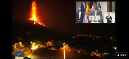
La Palma volcano gushing now, more than I can recall https://www.youtube.com/watch?v=ATZY4wntQ0g 2:08 am 3rd Oct 2021 La Palma time
2nd vent, from left, normally smoky, is now fully active and 3rd vent enlarging a bit – see https://drive.google.com/file/d/1ho9oZbQLTaO_52G9uj7ipJq3_8QdC_eX/view?usp=sharing
Around 2:20 am local time, low jet engine sound from the vents
03:04 am chunks of the hill on the right side are eroded away and fall into the yellow hot stream roilling along with a good speed
3rd vent seems to be a double gusher now https://www.youtube.com/watch?v=TiRBJNaLkHk
hummock between the 2 gushers of the 3rd vent seems to be sliding down the slope a little bit now, gradually exposing the gusher mouths. 2:48 am local time
2:52 am and the right side is being eaten away by the hot lava and that part of the hummock is being carved away.
My last comment on this view https://www.youtube.com/watch?v=TiRBJNaLkHk but sputtering has started for the flow outlet below the left hand gusher on the 3rd vent at 4:41 am La Palma time.
Is it possible the really deep fluid basantite has finally started erupting? The lava was fluid before but now it is like liquid steel…
Real lava rapid down the side of the cone now.
Found this on IMO, but it is in Icelandic, which I cannot read, can anyone translate into English?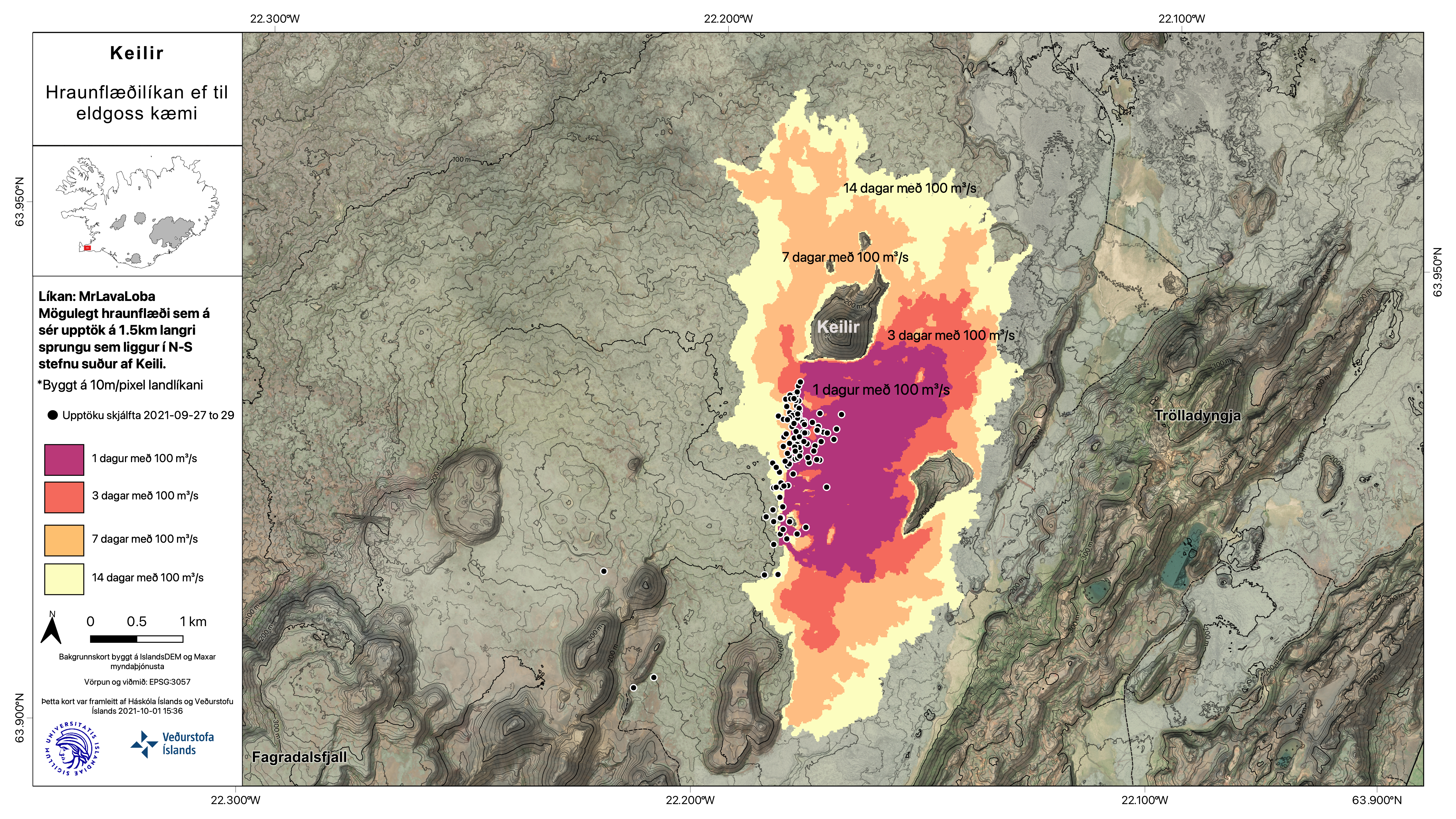 It has something to do with the latest earthquake swarm around Keilir
Talking about hwo far lava would from from a fissure south of Keilir at 100 m3/s effusion rate. That is very high flow rate though, I would expect it to flow further after 2 weeks really.
I like that they named the model MrLavaLoba.
Seems to me a predictable flow of lava IF an eruption starts from under the tremor spot, dark is the spread on the first day, yellow after two weeks of flow with 100m3 per second.
The location where we have the earthquakes is the same where the intrusion was this spring. The blockage at Fagradallsfjell is building more pressure which implies that when (likey, but otherwise if) the lava reaches the surface it will give a lot of output. I guess that is the reason for calculating with 100m3…
Fagradalsfjall is erupting at a rather low rate. (Well, it is zero now, but back when it still produced output.) It has a supply problem. There is (was) enough magma, but the pipeline has limited capacity. Imagine a fuel shortage on the magma forecourt (don’t know where I got that idea from.) This carrying limit is somewhere in the dike-conduit connection, because the eruption wasn’t high at the start either, at a time it fed solely from the dike pressure. The idea is that a new conduit may not have that problem and can erupt at a proper rate, at least initially. (This may also mean that such an eruption may not last long.)
At 15:32 there was a large, “wet” quake on the faf drumplot. Long, burbly coda. Magma is moving.
That’s the M4.2. I don’t think it’s wet, only large enough to make the ground keep ringing a little longer than the other quakes.
Video of Lava fan yesterday
https://twitter.com/DronSea/status/1444570506771025923
Hard to know but Las Palmas does seem a bit dark and possibly bigger?
Here are the earthquakes of the Keilier region for the last week, colored according to five more active periods. We see that while the quakes became less deep with time, they are not really shallow yet.
Been looking at Lanzarote again after all the stuff in La Palma, to me what is going on at Fagradalsfjall really does have a similarity.
Lanzarote isnt a fissure, it looks like it but it was really just a single vent relocating generally in an linear direction, each vent I expect would have looked exactly like the one on La Palma, but far as I can tell no more than 2 were active together. Lanzarote also just like Fagradalsfjall had not erupted in the Holocene before 1730, the first eruptions were floods of nephelinite lava from a singular vent in the center of the island, probably collecting at the base of the crust all that time, later eruptions were alkali olivine to tholeiite basalts from decompression melting with a general easterly trend from off the west coast back to the first eruption over 6 years.
Fagradalsfjall started slow but already is tholeiitic basalt, maybe even borderline ultramafic. As Albert says above the slow start might be a bottleneck in the crust rather than a fundamental feature, if there is an open conduit to 6 km depth I would expect magma to be rushing into the rift, forming a magma chamber, future eruptions for this cycle might even be entirely on this rift which would obviously involve some major landscaping. Being fresh gassy magma it will probably create tall fountains and bigger cones, like it already bas but many more. The skyline is going to be very different in 2050.
So the zone of activity is going deeper?
Odd.
Shallower, but only slightly. Noteworthy is also the ‘split’ into two layers since October.
No, the plot is reversed. Zero depth is at the bottom. The activity has become a bit shallower.
Just spotted this. Depth not height!
Our lunchtime TV news did a big feature on LaPalma’s second major lava stream. Put on a volcanologist who said, more or less, that eruption could last for days, weeks, even months. His colleagues are gas-sampling in hope of determining lava’s origins. If ‘stale’ magma, just a residual pocket, so probably short eruption. If ‘fresh’ or ‘evolving’, may last a lot longer, may become larger. As LaPalma’s eruptions are ‘infrequent’ on historical scale, no clear pattern. But, remember that entire island has been built from sea-bed by such eruptions…
News Presenter duly impressed…
Slightly cynically, I must wonder if this ‘theatre de fer’ was amusing distraction from rest of news’ spate of coups, revolutions, insurrections, famines and rigged elections…
Hmm: Is Vulcano’s current activity possibly related to the area’s remarkably wet weather several months back ? Would have raised the water table, the ground pressure. But, seems to have taken a rather long time…
Tangential, that ‘extra-tropical cyclone’ prowling Arabian Sea now seems determined to head through Gulf of Oman into Persian Gulf. Where there *may* be enough hot water to fuel its wander up to ‘Mesopotamia’, spawning a ‘Gilgamesh-grade’ River Flood…
Disclosure: Some of my friends had *abrasive* dealings with the marine version of Iranian Rev Guards. On their behalf, I must hope this storm with its 100+ kph winds and 5 metre surge *severely* impacts IRG gun-boats and port facilities…
Can someone explain why it looks like night in this url https://youtu.be/iRcs7KoiURg but the timestamp says daytime at around 14:00 hrs Oct 3rd today but this url https://youtu.be/INvrtMg5tSQ shows sunlight and claims to be live too? There was a moderate explosion from the 3rd vent at 13:55:42 which showed what this volcano is capable of
Yes, that is clearly not footage from now. My guess is that, as any tv station on a weekend would do, they are showing a rerun
Because the first stream is not live (and because nobody cares). Better we stick with the second stream, that should be TelevisionCanaria.
The murk just cleared a bit. I am unsure if this is fog or vog. If the latter it will not be good for anyone in it.
I am NOT happy that they stuck a current timestamp on the replay. That is misleading which is why I posted to ask the question.
https://twitter.com/CopernicusEMS/status/1444629684185096192
#LaPalma Volcano using a Very High Resolution Satellite image acquired on 2 October
Extent of the lava flow: 397.5 ha
946 destroyed houses have been detected
Copernicus also shows the northern flow and the known vents:
Another star at Keilir. It is staying deep – no indication that it is breaking through to the surface. Iceland’s crust is a tough nut to crack.
Looking at https://skjalftalisa.vedur.is/#/page/map and comparing to February/March, the current quakes are slightly further east, possibly on the edge of the the dyke?
https://www.youtube.com/watch?v=BTKTNSstI7g
looks like lava fountains maybe flowing into a lava tube in la palma
Yes, a lava tube has formed below the main effusive vent. This was already visible yesterday when the camera zoomed out. For a few minutes now, the effusive vent is going like mad. The vent is releasing a lot more lava and the flows are going in all directions down the northwest slope. Some of the remaining tree burdock are already burning.
Now it does only Viscous violent strombolian activity
La palma
Other Flood on the main lava vent….
once again absolute riot on the main vent and new flows in new directions.
I think the main vent is having structural issues. The rampart has collapsed and a boulder was dropping right under it. 9:13 pm CET.
20:18 pm CET very big lava chunks coming down the very large flow, looks like yellow orange jam spreading out everywhere on the mountainside and sliding down.
it certainly has Jesper pleasing quality. Is that finally the fresh stuff?
20:27 pm CET and another fresh gush comes ooshing out. The vent area looks just like hell, looking into the glowing incadescent yellow hot gases.
white hot lava coming out of one vent now at 20:35 pm CET.. just like Geldingadalir
20:29 pm and a large area is backed up trying to push the cooler material ahead of it. I hope we don’t have slope failure in this region.
I hope we don’t have slope failure due to the weight of the backed up hotter material being held up
The increase in the flow rate is accompanied by an increase in the tremor. We now have four different lava tongues moving north, northwest, west and west / southwest down the slope of the cone. Certainly they will unite at the northwest to the western base of the cone. Together with the lava from the northwestern effusive vent, they will take the previous route in southern and then western direction, I think (and hope).
white hot lava is now coming from the one vent and the lava is low viscosity
https://drive.google.com/file/d/1ojMBxj4kSVMn9zn04uavggY5D8quYfPY/view?usp=sharing
Can someone explain the morphological change to the vents, the past 8 hours, as I was asleep when changes occurred? I see a brand new flow area at my noontime, is that a new vent or just a course change for the lava flow on the left hand side of the camera? https://www.youtube.com/watch?v=BTKTNSstI7g
Judging from this live view https://www.youtube.com/watch?v=INvrtMg5tSQ, the effusive vent has entered kind of a cycle? From time to time much lava is coming out, and after that the flow really appears to diminish.
Unfortunately, the camera has an unusual high contrast setting, so really judging what is going on is not that easy.
On a side note: Again well visible is what I interpret being incandescent ash clouds. I don’t think this is chemical burning going on.
Kinda wish they took the exposure down a step. Effusive vent is undergoing short pulses of massive volume that show as pure white at this point. Effusive fountains are sizeable too.
Kinda wish they took the exposure down a step. Effusive vent is undergoing short pulses of massive volume that show as pure white at this point. Effusive fountains are sizeable too.
3.7 mbLg N FUENCALIENTE DE LA PALMA.ILP
2021/10/03 19:14:37
13
Lava flows video
https://twitter.com/ita_dc/status/1444746539138695183
and the rampart collapse. Any idea how large that boulder was?
At 20:39 pm CET, the lava is really gushing and exploding. I noticed that the lava from the one vent is now glowing white hot in the camera, not yellow and the far vent is really exploding.
La Palma is angry.
blob:https://imgur.com/0ddd68e7-f81f-488e-af88-338e87b9e417
please repost, as imgur.com complains that link cannot be found.
https://twitter.com/RTVCes/status/1444751733310332932
Partial cone collapse
Watching this the past hour, but right now at 21:29 pm CET, it looks like the cone is being corroded away and a deep channel is being cut into the side of the volcano complex, as chunks keep falling into the flowing lava channel.
a large boulder blocked exit from the vent, and is it about to give way. new massive flow starting
Very hard activity
Last earthquake
es2021tkagc 03/10/2021 19:14:37 20:14:37 28.5629 -17.8261 12 3.7mbLg III-IV SW VILLA DE MAZO.ILP
EVENTO: es2021tkagc 2021/10/03 19:14:37 28.5629 -17.8261 12 3.7 SW VILLA DE MAZO.ILP
Actualizado 2021-10-03 20:16 UTC
RELACIÓN DE INTENSIDADES (EMS) Y POBLACIONES
EN LAS QUE SE HA SENTIDO ESTE TERREMOTO:
III-IV LOS PEDREGALES,EL PASO.TF
III BARRIAL DE ARRIBA,EL PASO.TF
III CARDÓN,TAZACORTE.TF
III DOS PINOS,EL PASO.TF
III EL PORVENIR,BREÑA ALTA.TF
III EL PUEBLO.TF
III HERMOSILLA,LOS LLANOS DE ARIDANE.TF
III LAS INDIAS,FUENCALIENTE DE LA PALMA.TF
III LAS MARTELAS,LOS LLANOS DE ARIDANE.TF
III LOS CANARIOS.TF
III LOS CANCAJOS,BREÑA BAJA.TF
III LOS LLANOS DE ARIDANE.TF
III LOS PALOMARES,LOS LLANOS DE ARIDANE.TF
III LOS PEDREGALES,LOS LLANOS DE ARIDANE.TF
III MONTAÑA TENISCA,LOS LLANOS DE ARIDANE.TF
III PALMASOL,BREÑA ALTA.TF
III PASO DE ABAJO,EL PASO.TF
III PINO DE LA VIRGEN.TF
III RETAMAR,LOS LLANOS DE ARIDANE.TF
III SAN PEDRO.TF
III SAN SIMÓN,VILLA DE MAZO.TF
III TIGUERORTE,VILLA DE MAZO.TF
II-III AGUATAVAR,TIJARAFE.TF
II-III EL PASO.TF
II-III LAS CALETAS,FUENCALIENTE DE LA PALMA.TF
II-III LAS LAJITAS,SANTA CRUZ DE LA PALMA.TF
II-III LAS LEDAS,BREÑA ALTA.TF
II-III MONTE DE BREÑA,VILLA DE MAZO.TF
II-III PUERTO,TAZACORTE.TF
II-III SAN ANTONIO,BREÑA BAJA.TF
II-III SAN JOSÉ.TF
II-III SANTA CRUZ DE LA PALMA.TF
II-III TACANDE,EL PASO.TF
II-III TAZACORTE.TF
II ARGUAL,LOS LLANOS DE ARIDANE.TF
II BUNGALOWS DE TAJUYA,LOS LLANOS DE ARIDANE.TF
II EL BARRIAL,EL PASO.TF
II LA FAJANA,FUENCALIENTE DE LA PALMA.TF
II LA GRAMA,BREÑA ALTA.TF
II LA SABINA,VILLA DE MAZO.TF
II LOS BARROS,LOS LLANOS DE ARIDANE.TF
II MALPAÍS DE TRIANA,LOS LLANOS DE ARIDANE.TF
II MARINA,TAZACORTE.TF
II MIRANDA,BREÑA ALTA.TF
II TENDIÑA,LOS LLANOS DE ARIDANE.TF
I think that start moving to the east side. The vulcano has making a “build / destruction” series, raising very high, colapsing over the velts, closing them, making earthquakes, cleaning them and start againt.
21:34 pm CET and it seems like someone turned OFF the volcano. Is something coming up? Odd that it is calmed down now, oh wait something is starting … .hmmm 3rd vent has shifted a bit to the right and seems to be cutting new ground into the cone walls
21:39:51 pm CET entire cone went dark, like someone turned off the whole thing.
this could be a digital stream failure in the equipment
No they are changing the color or contrast…
The 3rd vent cutting into the right hand side is happening, it seems that the vent tried to go that direction for awhile, so there definitely is pressure from underneath trying to find a way out.
20:39 UTC, https://www.youtube.com/watch?v=INvrtMg5tSQ: If it wasn’t for the sound, you could think the eruption is coming to a close…
And of course, the lava cooled a bit too quickly 🙂
The tremor continue high and none has decreasing yet. Camera autofocus going dark?
It faded over 10 or 15 seconds. I suspect a camera or filter issue.
The 3rd vent has gone quiet (22:10 pm CET) but seemed to have tried to bubble up over to the right hand side cutting into the cone wall a bit
The brown smoke being emitted now makes me wonder if we will see the 3rd vent suddenly burst.
22:22 pm CET lava reactivated over to the left hand side and below the 3rd vent.. interesting…
Now I know what a ‘gassy’ eruption is like…..
The IGME/IGM team was retreat of The Laguna montain by dangerous gas concentrations.
https://youtu.be/p2MTleCSyt0
Other IGN severe eartquake
es2021tkeuv 03/10/2021 21:32:47 22:32:47 28.5592 -17.8264 12 3.5 mbLg III-IV NE FUENCALIENTE DE LA PALMA.IL
EVENTO: es2021tkeuv 2021/10/03 21:32:47 28.5615 -17.8320 12 3.5 NE FUENCALIENTE DE LA PALMA.IL
Actualizado 2021-10-03 21:47 UTC
RELACIÓN DE INTENSIDADES (EMS) Y POBLACIONES
EN LAS QUE SE HA SENTIDO ESTE TERREMOTO:
III-IV DOS PINOS,EL PASO.TF
III-IV JUAN MAYOR,SANTA CRUZ DE LA PALMA.TF
III-IV TENDIÑA,LOS LLANOS DE ARIDANE.TF
III BARRANCO DEL RÍO,SANTA CRUZ DE LA PALMA.TF
III BARRIAL DE ARRIBA,EL PASO.TF
III CARDÓN,TAZACORTE.TF
III EL JESUS,TIJARAFE.TF
III EL PORVENIR,BREÑA ALTA.TF
III LA LAGUNA,LOS LLANOS DE ARIDANE.TF
III LAS LAJITAS,SANTA CRUZ DE LA PALMA.TF
III LAS LEDAS,BREÑA BAJA.TF
III LODERO,VILLA DE MAZO.TF
III MONTAÑA TENISCA,LOS LLANOS DE ARIDANE.TF
III MONTE DE BREÑA,VILLA DE MAZO.TF
III PALMASOL II,BREÑA ALTA.TF
III PALMASOL,BREÑA ALTA.TF
III PASO DE ABAJO,EL PASO.TF
III RETAMAR,LOS LLANOS DE ARIDANE.TF
III ROQUE DE ABAJO,SANTA CRUZ DE LA PALMA.TF
III SAN ANTONIO,BREÑA BAJA.TF
III SAN JOSÉ.TF
III SAN PEDRO DE BREÑA ALTA,BREÑA ALTA.TF
II-III AGUATAVAR,TIJARAFE.TF
II-III ARGUAL,LOS LLANOS DE ARIDANE.TF
II-III BARLOVENTO.TF
II-III BUENAVISTA DE ABAJO,BREÑA ALTA.TF
II-III EL LLANITO,BREÑA ALTA.TF
II-III EL PASO.TF
II-III EL PUEBLO.TF
II-III HERMOSILLA,LOS LLANOS DE ARIDANE.TF
II-III LA MONTAÑA,BREÑA BAJA.TF
II-III LA POLVACERA,BREÑA BAJA.TF
II-III LA PORTADA,SANTA CRUZ DE LA PALMA.TF
II-III LAS LEDAS,BREÑA ALTA.TF
II-III LOS LLANOS DE ARIDANE.TF
II-III SANTA CRUZ DE LA PALMA.TF
II-III TACANDE,EL PASO.TF
II-III TRIANA,LOS LLANOS DE ARIDANE.TF
II EL FUERTE,BREÑA BAJA.TF
II EL PILAR,EL PASO.TF
II LA GRAMA,BREÑA ALTA.TF
II LOS CANARIOS.TF
II LOS CANCAJOS,BREÑA BAJA.TF
II LOS PEDREGALES,LOS LLANOS DE ARIDANE.TF
II MIRANDA,BREÑA ALTA.TF
II MONTE DE PUEBLO,VILLA DE MAZO.TF
II SAN PEDRO.TF
II TACANDE DE ABAJO,EL PASO.TF
The III-IV intensity has start to appears on the la palma east side and rise on the west side.
III-IV DOS PINOS,EL PASO.TF <- North of Tajuya
III-IV JUAN MAYOR,SANTA CRUZ DE LA PALMA.TF <- Over and West of Santa Cruz de la palma
III-IV TENDIÑA,LOS LLANOS DE ARIDANE.TF <- North Tajuya, South of Dos pinos.
3.5 mbLg NW FUENCALIENTE DE LA PALMA.IL
2021/10/03 22:06:59
10
+info
3.5 mbLg NE FUENCALIENTE DE LA PALMA.IL
2021/10/03 21:32:47III
12
+info
3.7 mbLg SW VILLA DE MAZO.ILP
2021/10/03 19:14:37III-IV
12
the depth of these quakes is staying about the same, suggesting more magma on the way, a lot more.
Video from Volcanes de canarias on FB…. can see the “flodding” when the pool has broken (I think).
https://fb.watch/8pVJSasnV1/
the people talk about that night the vulcano has very intensive and the houses sheking….
That’s a great vid, thanks!
Side note: it requires a facebook Login, which I don’t have. The easiest way to bypass that (that I know of) is to use an unsupported browser. That gives you a “simpler” interface without the popover nag login screen.
Big!
As of midnight, Monday 2021-Oct-4 CET all 3 or 4 of the vents have successfully been able to carve away any debris or spatter that separated them and lava is now freely flowing across the vents. This is the first time that this has happened, which means that the lava temperatures are rising. The vents seem firmly fixed as to their original locations, this probably won’t change, but clearly the increased temperature and explosive bursts has cleared away the obstructions between the vents and lava is freely flowing from the most gaseous vent south towards the north vents and then out.
The announcers now at 12:23 pm talking rapidly, voices elevated
I see lots of cars and trucks on that street at midnight now, clearly the population is evacuating and saddens me.
Two more:
– 3.4 mbLg N FUENCALIENTE DE LA PALMA.ILP 2021/10/03 23:07:23 11
– 3.4 mbLg NE FUENCALIENTE DE LA PALMA.IL 2021/10/03 22:58:26 12
Big blob of lava below the vents just blubbed and moving down, big big blob, white in the camera. 12:20 pm CET
Oh. La Palma Volcano just went out. Venting away like mad and then…phllllhhh…. disappeared. 00:37.
Assume it must be Vog.
Cam fail. Others:
https://www.youtube.com/watch?v=ATZY4wntQ0g
I clicked around a few cams but they were all the same. Must be the one feed that went down. Thanks for this replacement!
I noticed the TV Canarias stream went completely dark, not even glow from the lava streams or any residual lava in the vents, so probably a technical issue.
TV La Palma stream is still going, though.
An awesome vid of the La Palma plume hitting the top of an inversion around 5km, where upper air from the Sahara overrides the cooler oceanic airmass.
The waves in the clouds resemble gravity waves…but in this case the waves are caused by pulses on the volcanic plume. Pretty cool.
https://twitter.com/i/status/1444409488442863617
Kilauea Volcano Eruption Update, Vents Feed Lava Lake (Oct. 3, 2021)
Big Island Video News
The video here is interesting but the narrative merely regurgitates the HVO reports in my email.
https://twitter.com/nourefidel/status/1444719519826649093 shows that the La Palma lava is dropping in viscosity
I think that’s actually Hawaii from 2018.
It is Hawaii, but maybe not too far off really, the lava is pretty runny now and flowing down a steep slope.
You probably are right.. seems that twitter is being flooded with fake videos now.. maybe a tsunami of them? The true tsunami? More and more fake digital data until finally it completely overwhelms the internet?
Interesting colours on the lava lake at kilauea. The surface of lava erupting from the vent on the side of the lake is a nice shiny silver while the lava erupting from vents in the lake itself is a more dull grey. Looks like lava from the deeper lake is being pushed out onto the surface, while the side vent is fresh, which might also be why it has a bigger gas plume too.
Will be interesting to see how this lake evolves, I would expect it to at least last to the end of the year and coudl well last for a lot longer, the tilt has already pretty much bottomed out so there is no significant pressure relief, it is all in equilibrium and the deep vents will not be able to cool, so should just get wider and form a new open conduit.
Probably the lake will just keep slowly rising and filling the caldera until a rift eruption happens, probably when it gets to around 800 meters elevation or more so still a ways to go yet.
Have the summer 2021 lava lake crust now melted competely? Or is that layer still inside under the new liquid layer?
Seems to be there still, the islands stay fixed relative to each other. Probably the lava above the crust is gas rich, the lake might well subside again if the eruption becomes more open.
I’m finding the HVO reporting dull, repetitive and disinteresting.
It’s written by bureaucrats, a stylebook created by risk-averse lawyers in Denver, Colorado and Washington, DC.
Some of their cut-n-paste dialogue would be hilarious if I weren’t paying for it–their reassurances that those in the field are wearing their PPE, also that they’re doing fieldwork in the National Park and they have the permission and approval of HVNP–which is another government entity!
I used to think that Jaggar and MacDonald’s writings were dry, but they’re the music of the spheres compared to the disclosures and disclaimers the wonks create now.
RE:”I used to think that Jaggar and MacDonald’s writings were dry,…”
I’ve had Jaggar’s ‘Volcanoes Declare War’ in my library at least 70 years. To an 8 year old his chapters seemed matter of fact. I often wondered what it might be like to serve as a volunteer Interpretive Guide out there. Is the staff at HVO as uninspiring as their narratives. I met a member of the science staff out there in ’03 who did not seem to be. I got look into Jaggar’s lab under the hotel. after telling him I owned the book. “Haven’t yet met anyone else who said that.” he replied.
In case someone wants to look at a live multistream:
https://www.youtube-multistream.fr/multistream.php?id1=_u49m6I5Mpw&id2=ATZY4wntQ0g&id3=ZV7MUfGs_1U&id4=ngHMnPdjnR4
Many thanks, I think
https://www.youtube.com/watch?v=ATZY4wntQ0g
is actually live, too.
Thank you very much!
I didn’t know there was such a service in the first place 🙂
just now 3.7 in a row of 3.points since the evening.. is it ramping up to something much bigger (sorry for my layish expression)
http://www.ign.es/web/resources/volcanologia/tproximos/canarias.html#