
The island of Vulcano (source: wikipedia)
The volcano helpfully called ‘Vulcano’, one of the islands, north of Sicilyhas give its name to all volcanoes in the world. Vulcano last eruption was in 1888-1890. During the long repose period, a settlement has grown from a few houses to villas and hotels. Frazzetta et al. wrote in 1984 (quoted by Boris Behncke)
“A volcanic hazard exists where there is the potential for loss of life or property as the direct result of volcanic activity. The major effects of all activity at Fossa are confined to within 2 km of the vent. The village of Porto with a population of about 250 inhabitants lies within this zone to the north of the main cone. During the summer the population of this town swells to more than 10,000. It is quite dangerous for a village to be located so close to an active volcano.”
The settled community has grown from 250 to 450 since 1984, and in August there may now be 12,000 tourists each day (Behncke, private communication). The location of this community so close to the crater has made Vulcano into the second most dangerous volcano in Italy, after only Vesuvius. And now the alert level has been raised to yellow. Luckily this is after the summer and the height of the tourist season. But we are concerned.
The following post is one from the archives. It was written by Henrik in 2013, and is well worth resurrecting. At the end, we also reproduce a description of past eruptions from the current crater, Fossa, based on an article by Boris Behncke and reproduced by permission.
Over to Henrik:

Fig 1. “The Thunderbolts of Zeus”. One of the amazing photographs taken by the incomparable Marco Fulle, often reproduced on the Internet without giving credit to this wonderful photographer.
Hephaistos, the lame son of Zeus and Hera, the King and Queen of the Hellenistic Pantheon, was the god of blacksmiths, artisans, craftsmen, metals, metallurgy, fire and volcanoes. He was also the weaponsmith of the Gods and crafted, amongst other things, the thunderbolts of Zeus.
Of course the Romans, the greatest copyright infringers ever produced by mankind incorporated the Greek Pantheon as their own religion and mythology. Here, Hephaistos was known as Vulcanus. The roman scholar Marcus Terentius Varro (116 – 27 BC) cites the Annales Maximus, which go back to at least 400 BC, as the source of the first mention of Vulcanus. He mentions that king Titus Tatius (d.748 BC) dedicated a series of altars to deities among which Vulcan is mentioned.
Perhaps more suggestive is the fact that a new eruptive centre formed in the strait between Vulcano and Lipari with the first recorded eruption occurring in 183 or 123 BC. The eruptions went on for more than a century, thus were contemporary with Varro, and formed a new island Vulcanello. This was volcanic creation of new land where only sea had been before and must have been considered by the ancient world as very significant proof of divine existence and omnipotence. In addition to its theological usefulness, Vulcano provided the Romans with wood, alum and sulphur, activities continued as the main produce of the island until the last, or rather, most recent series of eruptions of 1888-90 ruined the mining works. Today, Vulcano is home to some 500 year-round inhabitants while in the summer, the population grows to about 10,000. But not to worry, renewed activity will almost certainly be preceded by irrefutable signs of unrest well in advance of any potentially devastating event.
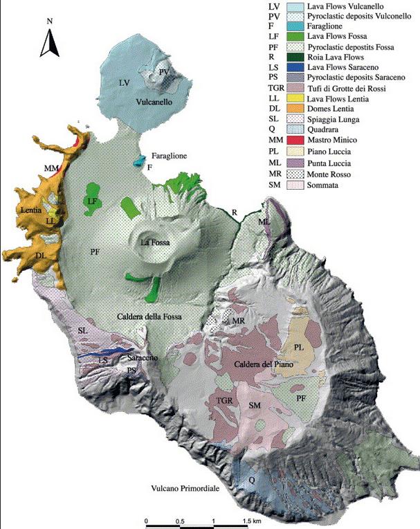
Fig 2. Geology of Vulcano (Gioncada, Mazzuoli, Bisson & Pareschi 2003)
The visual appearance of Vulcano is very suggestive with the most ancient centre of activity, the collapsed stratovolcano “South Vulcano” (ca. 120-98 kA) and Piano Caldera (ca. 98-97 kA) to the south, the Lentia Complex (15.5 kA) with the Lentia or Fossa Caldera (16 -13 kA) in which the new La Fossa cone (~6 to 5 kA) grew. To the NE of the Fossa cone an extrusion is obvious but no date has been given for it (14 kA Punta Roja lava flow?). Finally, to the north is the already mentioned Vulcanello complex (2.1 kA).
Activity at Vulcano began a mere 150,000 years ago and is divided into four major stages. The first, South Vulcano center, began at about 120 kA by building a trachybasaltic to trachyandesitic stratovolcano where pyroclastic fall and flow deposits constitute only a minor portion. The activity at South Vulcano came to an end with the collapse of the stratovolcano around 97 kA into the 2.5 km diameter Caldera del Piano. Interestingly, it seems that the caldera was formed, not by an eruption that led to a collapse but the collapse of the stratovolcano “for reasons unknown or unspecified”. Post-caldera activity continued for some 45,000 years which resulted in most of the caldera being filled by lava flows. Then there seems to have been a period of inactivity covering the next 30,000 years.
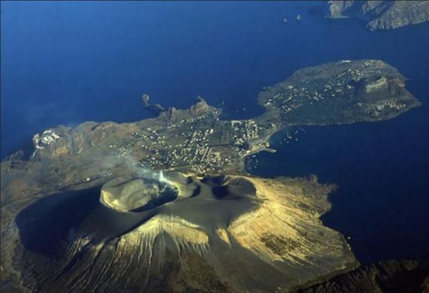
Fig 3. Looking north. An aerial photograph of the infilled Lentia Caldera with the Gran Cratere of the La Fossa Cone and island of Vulcanello
About 15½ thousand years ago, activity renewed at Quadrara and Spiaggia Lunga as well as the formation of the large rhyolitic to trachytic lava dome and flow complex of Lentia, the “Lentia Lava Dome Complex”, in the northwest. From somewhere in the strait between Vulcano and Lipari (proto-Vulcanello?) violent ash-flow forming eruptions occurred and deposited brown tuffs over a large area of the old Caldera del Piano to the south.
About 15-14 ka ago, another caldera collapse affected the island, this time in its northern part, forming the Lentia caldera. Again, there seems to have been no explosive eruption associated with the caldera collapse, which may have been “tectonically triggered”. Activity continued within the new caldera with at least five cycles of pyroclastic and lava flows, the most significant being the Punta Roja lava flow that crops out at the E base of the La Fossa cone. Eruptions also occurred from N-S trending fissures in the NW part of the older Piano caldera where the Alighieri formation and the edifice of Monte Saraceno were formed.

Fig 4. Inside the Gran Cratere of La Fossa (volcano.oregonstate.edu)
About 11,000 years ago, activity began to concentrate in the centre of the Lentia Caldera and at least four eruptive cycles formed the massive-looking albeit only 391 m high La Fossa cone. Over the past 2½ thousand years, there have been at least 15 confirmed eruptions with a further ten possible from La Fossa with the last terminating on March 22nd 1890.
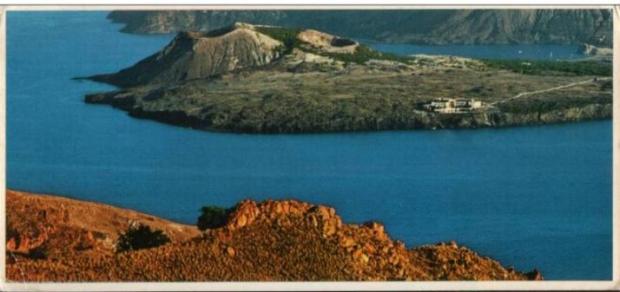
Fig 5. A post card of Vulcanello from Lipari
Although activity at La Fossa continues and cannot be said to be over, the last major eruptive period recognised is the already mentioned one that began in the second century BC and led to the formation of the Vulcanello Island and complex. Eruptive activity continued with at least two further eruptions after the initial, island forming series ended in ~10 AD. The final eruption, that of 1550, connected Vulcanello with Vulcano. The activity produced three overlapping tephra and scoria cones with craters shifting from E to W, and a gently sloping lava platform mainly on the N, W and S sides of the cone cluster. The Vulcanello products are generally more mafic than most other Vulcano eruptives, being of leucite-tephritic composition, only the most recent lava flow, Punta del Roveto of 1550 being trachytic.
HENRIK

Fossa, 2018. Source: Volcanodiscovery
Henrik ended his post with: For further reading, I highly recommend Dr Boris Behncke’s former site, thankfully saved for posterity by the Michigan Technological University
This site does not appear to exist any more. We reproduce here part of the content, describing the eruptive cycles of the Fossa cone over the past 6000 years. The text is slightly edited from the original. The images as shown here are available at https://slidetodoc.com/3-volcanoes-killers-and-creators-dr-daniel-barker/
The evolution of the Fossa cone, the most recently active volcanic center on Vulcano island, has been described in detail by Frazzetta et al. (1983) and briefly reviewed by Frazzetta et al. (1984) and Frazzetta & La Volpe (1991). The following is a summary from those sources.
The Fossa eruptive center developed only during the past 6000 years, after the presumably tectonically triggered formation of the Fossa caldera, about 14-16 ka ago. Its birth followed post-caldera effusive activity of which the 14 ka Punta Roja lava flow gives testimony. Activity of the Fossa cone has been divided into several cycles by Frazzetta et al. (1983, 1984) and Frazzetta & La Volpe (1991). The cycles have generally shown a characteristic succession of eruptive styles and each had an individual eruptive vent. Some cycles began with powerful vent-clearing explosions leading to deposition of “phreatic breccias” near the eruptive vents. The hydromagmatic initial stages of other cycles produced wet and/or dry surge deposits. Later products of each cycle show a decreasing influence of external water, the final products being fully magmatic (pumice-fall deposits or lava flows).
There is a complete lack of erosional surfaces and paleosoils between the products representing a cycle. It is assumed that activity during each cycle was more or less continuous. This contrasts with distinct erosional unconformities between the products of various cycles, evidence of longer repose periods separating different eruptive cycles.
Punte Nere cycle
The initial activity of this first recognized Fossa eruptive cycle was hydromagmatic and produced a more than 60 m thick sheet of dry surge deposits overlying the Punta Roia lava flows (14±6 ka). The basal strata of this sheet are composed of coarse and fine clasts and are overlain by sandwave and massive beds. Fragments of a trachytic lava flow that may have been ruptured by the eruptions and a thick block-fall deposit are present in the middle part of the sequence. A fall deposit composed of normally bedded and occasional reversely bedded layers with interbedded surge beds make up the uppermost pyroclastic unit of the cycle. It was followed by the emplacement of the trachytic Punte Nere lava flow that forms a delta-like feature on the N base of the Fossa cone. This flow was dated at 5400±1300 years.
Frazzetta & La Volpe (1991) estimate the volume of tephra produced during the Punta Nere cycle at 195 x 106 m3 and that of lava at about 3 x 10⁶ m3. The activity left a cone about 250 m high. The NE crater rim is still well discernible in the eastern part of the Fossa cone.
At least three undefined eruptive cycles occurred after the Punta Nere cycle and left wet and dry surge deposits as well as the Campo Sportivo lava flow (see the map of lava flows), on the NW base of the Fossa cone. That flow has a radiometric age of 4600±1700 years and thus falls into the same time window as the Punta Nere flow; stratigraphically, though, it lies in a higher position. The volume of the Campo Sportivo lava flow is 2.6 x 10⁶ m3 while that of the tephra presumably associated with it is 25 x 106 m3. The volume of tephra from the other undefined cycles is about 10 x 106 m3.
Palizzi cycle
Following a repose period of unknown duration, hydromagmatic activity led to the emplacement of wet surge deposits followed by dry surge beds. Accretionary lapilli in these initial deposits give testimony of a high water component during the opening stage of the cycle. Later activity produced a stratified, normally graded pumice horizon which shows evidence of a brief erosional interval at its top. When activity resumed, it was again hydromagmatic and deposited another set of basal wet and overlying dry surge horizons.
Like during the preceding cycle, the late stage activity was effusive, producing about 0.6 x 10^6 m^3 of trachytic lava that forms a narrow tongue on the southern flank of the Fossa cone (Palizzi lava flow, see the map of lava flows). The volume of all tephra emitted during the Palizzi cycle is given as 5 x 10⁶ m3. The age of the Palizzi lava flow is 1600±1000 years. This is well within the historic period but no correlation of the deposits with recorded historic eruptions of Vulcano is possible.
Comenda cycle
This cycle began with powerful explosive activity of which a basal breccia gives testimony. The breccia is composed of yellow hydrothermally altered clasts and is overlain by a pyroclastic flow unit with numerous fumarolic degassing pipes. The activity then shifted to hydromagmatic and produced wet and then dry surge deposits with abundant Pele’s hair (!) before it became again magmatic with the extrusion of the Comenda obsidian lava flow that is still partially visible on the SW flank of Fossa cone (see the map of lava flows). Its volume is 2.6 x 10⁶ m3, slightly more than one tenth of the tephra volume (25 x 106 m3).
Frazzetta et al. (1983) assumed that the upper and larger of the two Forgia Vecchia (“Old Forge”) craters was formed during the Comenda eruptive cycle. These craters are well distinguishable on the two photos below of the 1888-1890 eruption but have been subjected to intense erosion since then and are densely vegetated.
The initial activity (breccia and pyroclastic flow) probably occurred before the mid 6th century AD since these deposits are overlain by the white ash from the most recent explosive eruption of Monte Pilato, Lipari that is thought to have occurred around AD 550. The Pilato ash is overlain by the wet and dry surge deposits. Historic documents indicate that the emplacement of the Comenda lava flow may correspond to an eruption recorded for the year AD 785.
Pietre Cotte cycle
Initial activity was hydromagmatic, producing wet surge and soon after, dry surge deposits. A pyroclastic fall sequence (described as “pumice” by Frazzetta and La Volpe 1991) rests on top of these early products. The exact timing of the eruption’s beginning is not known but it is probable that one of its more peculiar events, the formation of the lateral Forgia Vecchia II crater (on the NW rim of Forgia Vecchia I crater), occurred in 1727. Twelve years later, lava seems to have filled the main Fossa crater and spilled over its low N rim, forming the obsidian lava tongue of Pietre Cotte (“Cooked Stones”) that is still conspicuous on the steep northern slope of the Fossa cone (see the map of lava flows). Its volume is 2.4 x 10⁶ m3.
Unlike other cycles, the Pietre Cotte cycle apparently did not end with the lava outflow. Following the effusive activity, eruptions resumed in 1771 and continued intermittently until 1890. All activity before the latest major eruptive episode, in 1888-1890, is not well documented whereas very detailed scientific descriptions of the most recent activity are available (see below).
1888-1890 eruption
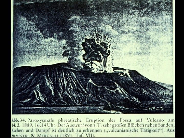
Photo of Vulcano in eruption, 14 February 1889. This view is of an explosion that ejects large bombs or blocks above a steam and ash plume. This photo was originally published in Mercalli & Silvestri (1891) and shows evidence of slight editing.
Vulcano last erupted in 1888-1890. Although it had erupted frequently in historic times, this eruption was the only one that was observed by scientists and was described in detail (Mercalli & Silvestri 1891). The activity observed by them was used for the introduction of a new scientific term, the so-called “Vulcanian” style of volcanic activity, now applied for powerful magmatic activity somewhere transitional between Strombolian and sub-Plinian.
The eruption was particular for the ejection of countless large breadcrust bombs. Meter-sized bombs fell in the area now occupied by the village of Vulcano Porto, on the crater rim they are much larger.
This is the largest of the famous breadcrust bombs ejected during the 1888-1890 eruption from Fosa Grande (the crater visible in the background). Giada Giuntoli is the person who gives scale. This bomb didn’t make it far away from the crater, but smaller ones fell abundantly in the area now occupied by the village of Vulcano Porto. 18 April 1995.
The buildings of the sulfur mining company located at Porto Levante were heavily damaged by falling tephra already during the first days of the eruption (starting on 3 August 1888), their residents could escape without fatalities or injuries. Later eruptions caused occasional ash and rare lapilli falls at Lipari. No major damage was done there, but the area now occupied by the village of Vulcano Porto was subjected to heavy bomb and lapilli showers.
The eruption ended on 22 March 1890, after gradually declining for several days. There were repeated unconfirmed reports about eruptive unrest at or near Vulcano, but no significant eruptive activity took place after 22 March 1890.
With the 1888-1890 eruption, the Pietre Cotte cycle seems to have come to a close. The volume of tephra produced during the entire cycle is given by Frazzetta & La Volpe as 25 x 106 m3 of which the 1888-1890 products do not make up more than one fourth.


The new lava lake of Nyiragongo. Just 4 months of sleep, similar to what happened after its previous flank outbreak in 2002.
How Big is the lava lake?
Yes I know its back .. and its a real open conduit lake too
https://phys.org/news/2021-09-lava-lake-dr-congo-volcano.html?fbclid=IwAR2hIdi6FhmD0MwvliVXWoUm9UdWXmJOJr0CleBaRCOICjTEbajKbRtrTuI
Why do Nyiragongos lava lakes do not generaly look like Kilaūeas?
Is it difftent convection, and gas content?
The viscosity is similar for both
Nyiragongo is the most massive Nephelinite system on the planet for now and very very active for being a Nephelinite too!
Probably the composition and the gas content, Nyiragongo probably has a lower magma flux and a higher gas content per volume, and the lava is maybe not as hot and possibly slighly more viscous at the surface level.
Could be something else though, because Kilauea has more silica in its magma it can form a stronger surface layer, that might well be the only factor really, alkaline magmas might not form a glass layer on cooling.
Perhaps .. yes Nyiragongos lavas does not have Hawaiis shiney crusts .. Despite being very fluid
Still the measured viscosity for Nyiragongos lava lake been extraodinary low
As low as Hawaiis lowest viscosity measurements
Nyiragongos melt is so unpolymerized that it haves difficult to form peles hairs even
Probably the second option then, the lava doesnt form a mechanically strong glass layer. Alkaline pahoehoe is not that shiny even fresh, it is always black. Fresh tholeiite lava it is easy to tell pahoehoe and a’a apart but alkaline lava looks pretty much the same.
Nyiragongo probably has such alkaline magmas because its source is very deep, underneath continental crust that is very thick still even if it is fractured, so large melt generation still. Same is probably true of Etna, powerful but deep melt source, higher pressure limits partial melting but a lot of magma is still generated. Hawaii and Iceland have high temperatures close to the surface so melting is much greater.
Canary islands might be like this too, long term melt generation is low but that assumes it is continuous, it seems in reality to be very episodic and peaks see much more powerful melt generation. On Lanzarote the first flows in 1730 were nephelinite flood lavas from a magma chamber but flows were alkali olivine to tholeiite basalts after 1731, relatively low rate, 30 m3/s or so on average though variable. Probably extension and some rifting triggered shallow decompression melting under the island, that is actually where I got the Hell Machine idea from 🙂
https://www.trekearth.com/gallery/Africa/Congo_Democratic_Republic/North/Nord-Kivu/Nyiragongo/photo1319725.htm
A fluid lava bubbling in Nyiragongo lake .. looks as fluid as Hawaii
I’m so glad your lake came back.
Video from yesterday
https://twitter.com/DronSea/status/1444942176371232769
twitter cannot find this page, please repost, thank you.
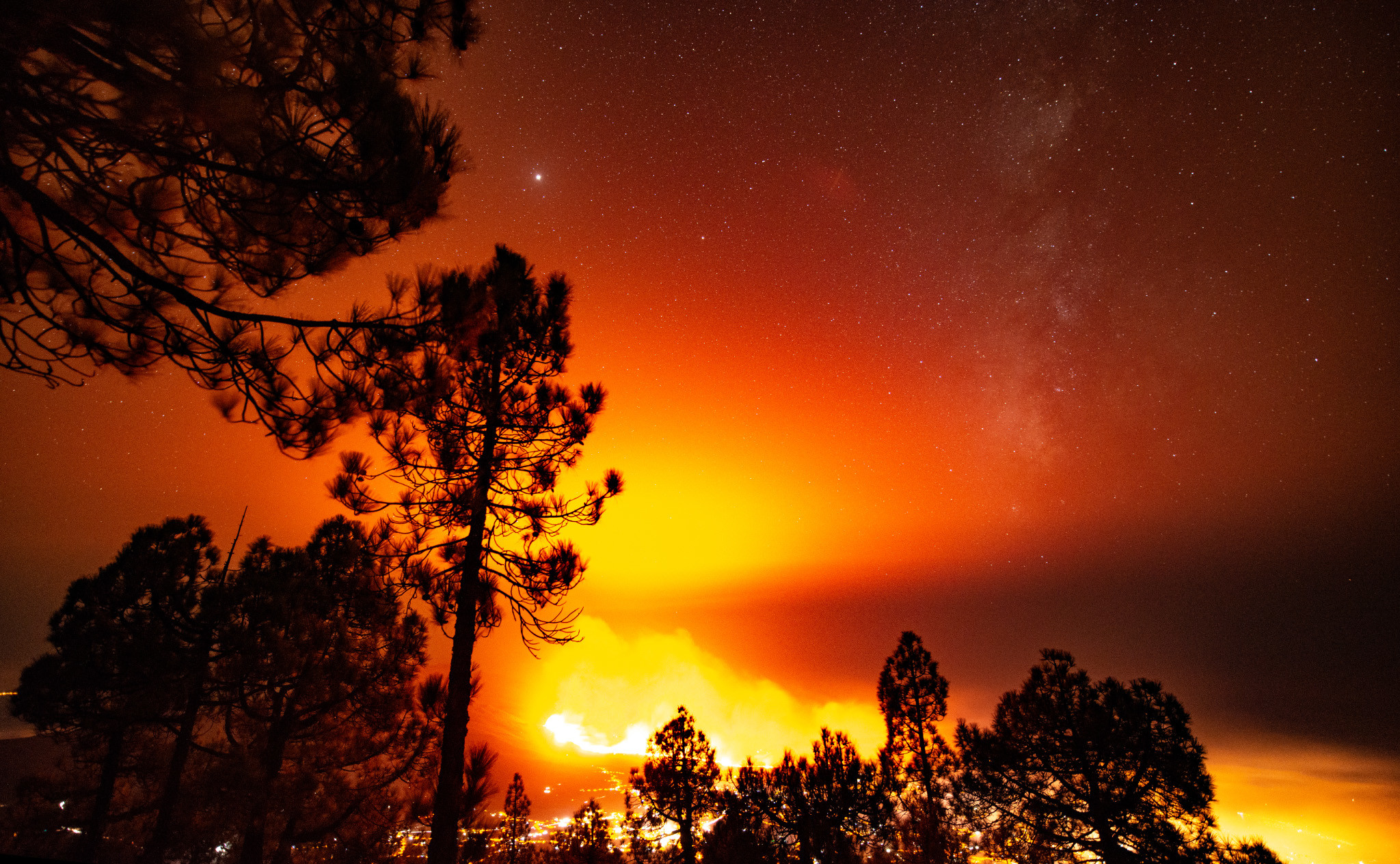
Lava fountains yesterday between 600 to 700m
https://twitter.com/VolcansCanarias/status/1444801331449978880
Video
https://twitter.com/VolcansCanarias/status/1444795523513335811
Luis,
Is the fog due to weather, or vog from the volcano?
I think it’s fog or low clowds…
And smoke too…
Is there a decent view of the vents, now that the TVCanarias camera seems to have broken/been pinched? All I can find are distant cloudy/voggy views.
Volcanic bombs…
https://twitter.com/involcan/status/1444959818301820930
That would really spoil your day.
Yesterday volcanic bombs near working side by Involcan.
https://twitter.com/involcan/status/1444959818301820930
SO4 levels by involcan
https://pbs.twimg.com/media/FA1yKRoXoAEFsOk?format=jpg
The night and Afternoon has been interesting:
2.9 mbLg NE FUENCALIENTE DE LA PALMA.IL 2021/10/04 09:37:48 30
2.8 mbLg NE FUENCALIENTE DE LA PALMA.IL 2021/10/04 08:58:08 12
2.7 mbLg SW VILLA DE MAZO.ILP 2021/10/04 08:34:45 14
2.6 mbLg NE FUENCALIENTE DE LA PALMA.IL 2021/10/04 08:12:42 12
3.2 mbLg NE FUENCALIENTE DE LA PALMA.IL 2021/10/04 07:59:57 13
2.6 mbLg NE FUENCALIENTE DE LA PALMA.IL 2021/10/04 07:50:42 10
3.3 mbLg SW VILLA DE MAZO.ILP 2021/10/04 07:46:32 12
2.7 mbLg NE FUENCALIENTE DE LA PALMA.IL 2021/10/04 07:38:05 10
3.3 mbLg NE FUENCALIENTE DE LA PALMA.IL 2021/10/04 07:33:59 III 11
2.7 mbLg NE FUENCALIENTE DE LA PALMA.IL 2021/10/04 06:51:19 11
3.1 mbLg SW VILLA DE MAZO.ILP 2021/10/04 06:44:1114
2.8 mbLg NE FUENCALIENTE DE LA PALMA.IL 2021/10/04 06:33:42 10
3.4 mbLg SW VILLA DE MAZO.ILP 2021/10/04 06:20:23 III-IV 13
3.2 mbLg SW VILLA DE MAZO.ILP 2021/10/04 06:17:57 12
3.0 mbLg NE FUENCALIENTE DE LA PALMA.IL 2021/10/04 06:01:12 13
2.5 mbLg NE FUENCALIENTE DE LA PALMA.IL 2021/10/04 05:49:46 11
3.0 mbLg NE FUENCALIENTE DE LA PALMA.IL 2021/10/04 05:44:27 S 12
3.4 mbLg NE FUENCALIENTE DE LA PALMA.IL 2021/10/04 05:36:08 14
2.5 mbLg N FUENCALIENTE DE LA PALMA.ILP 2021/10/04 05:31:44 11
2.8 mbLg SW VILLA DE MAZO.ILP 2021/10/04 05:21:55 S 11
2.9 mbLg SW VILLA DE MAZO.ILP 2021/10/04 05:12:21 12
2.6 mbLg NE FUENCALIENTE DE LA PALMA.IL 2021/10/04 05:10:48 14
3.1 mbLg NE FUENCALIENTE DE LA PALMA.IL 2021/10/04 04:48:56 14
2.5 mbLg NW FUENCALIENTE DE LA PALMA.IL 2021/10/04 03:58:21 14
2.5 mbLg NE FUENCALIENTE DE LA PALMA.IL 2021/10/04 03:36:29 14
2.8 mbLg N FUENCALIENTE DE LA PALMA.ILP 2021/10/04 03:23:42 14
3.0 mbLg SW VILLA DE MAZO.ILP 2021/10/04 03:23:12 15
2.6 mbLg SW VILLA DE MAZO.ILP 2021/10/04 03:20:03 11
2.6 mbLg SW VILLA DE MAZO.ILP 2021/10/04 03:10:55 13
2.9 mbLg N FUENCALIENTE DE LA PALMA.ILP 2021/10/04 02:59:10 11
2.9 mbLg N FUENCALIENTE DE LA PALMA.ILP 2021/10/04 02:43:29 13
2.5 mbLg SW VILLA DE MAZO.ILP 2021/10/04 02:39:22 13
2.9 mbLg SW VILLA DE MAZO.ILP 2021/10/04 02:24:0111
2.4 mbLg SW VILLA DE MAZO.ILP 2021/10/04 02:07:44 11
2.5 mbLg N FUENCALIENTE DE LA PALMA.ILP 2021/10/04 02:05:45 12
2.9 mbLg N FUENCALIENTE DE LA PALMA.ILP 2021/10/04 01:33:40 11
2.6 mbLg N FUENCALIENTE DE LA PALMA.ILP 2021/10/04 01:02:57 14
2.6 mbLg SW VILLA DE MAZO.ILP 2021/10/04 01:00:31 12
2.7 mbLg SW VILLA DE MAZO.ILP 2021/10/04 00:36:09 13
2.5 mbLg SW VILLA DE MAZO.ILP 2021/10/04 00:34:10 11
2.5 mbLg N FUENCALIENTE DE LA PALMA.ILP 2021/10/04 00:25:53 13
2.4 mbLg N FUENCALIENTE DE LA PALMA.ILP 2021/10/04 00:24:46 7
3.4 mbLg N FUENCALIENTE DE LA PALMA.ILP
2021/10/04 09:55:47
11
Video of lava flow and volcanic fan
https://twitter.com/RTVCes/status/1444992165822803971
Been doing research, the lava erupting now is tephrite but I think there was confusion somewhere. Tephrite and basantite are basically the same, alkaline mafic rocks, except tephrite has no olivine, tephrite is still basalt.
In practice this means even up to now all the lava erupted on La Palma has at least had time to settle out, it is not pristine deep melt. Far as I know other historic eruptions by equivalent volume had long become basantite, erupting olivine, that might suggest this eruption is going to be a lot bigger than the historical predecessors. Perhaps this is the grand finale to a period of high activity on the island.
I’m by no means a geologist but judging from the TAS diagram I already started to ponder what is the deal between tephrite and basanite, since thea are in the same field..?
Is the fact that we’re missing olivine the crucial difference then?
What about differences in fluidity? Is it noticeable?
Depends on Temperatures
Temperatures effect the sillica polymerisation alot.
Mount Erebus erupts a high sillica Phonolite ( can be called a very very alkaline dacite ) But it erupts Phonolites at 1100 C, so they are quite fluid because of high temperatures
It takes an Impressive ammount of thermal energy to heat high sillicate magmas to high temperatures
Most other Phonolites forms domes
Phonolite is more like andesite than dacite, in SiO2 content, seems very alkaline rocks dont really have a felsic member, almost like they are exclusive though I am probably wrong on that. Trachyte is like dacite or rhyolite and is an alkaline rock but not a direct evolution from phonolite.
But definitely there must be a crazy heat source to give a fluid lava lake to what is basically an exotic andesite volcano.
Erebus is the Only higher viscosity real lava lake on Earth at current
What woud a Ryholite heated to 1250 C flow like?
Most silliceous flows erupts at well under 1000 C
Tephrite – A type of tephritic-rock. In the Rock Classification Scheme, this name is used for a fine-grained crystalline igneous rock when the modal mineralogy is available, and the mineral mode plots in field 14 of the quartz – alkali feldspar – plagioclase – feldspathoid (QAPF) diagram. Basanite and tephrite are distinguished by the amount of olivine in the CIPW norm: if normative olivine is less than 10% the rock is tephrite. British Geological Survey
Basanite – A type of tephritic-rock. In the Rock Classification Scheme, this name is used for a fine-grained crystalline igneous rock when the modal mineralogy is available, and the mineral mode plots in field 14 of the quartz – alkali feldspar – plagioclase – feldspathoid (QAPF) diagram. Basanite and tephrite are distinguished by the amount of olivine in the CIPW norm: if normative olivine exceeds 10% the rock is basanite. British Geological Survey Research
What I cannot find is if one converts to the other and if so under what conditions.
…..and I thought Neuroanatomy, Virology, Immunology and Genetics were detailed.
chad, that’s a very interesting point you bring up, how do we know that olivine is found in La Palma lavas? I am not familiar in depth with the volcanology of La Palma, obviously. I have read that olivine forms deep down so I understand that seeing it would suggest deep melt coming up. Can we count on this for this current eruption? The quakes occurring at 11 km depth, is that deep enough for olivine or are we talking deeper?
Very black smoke from some time now…
https://twitter.com/VolcansCanarias/status/1445003348940410881
Looks Vulcanian to me…:-)
I visited La Palma early last week and took some photos of the eruption from different perspectives from the north and the easy. I have uploaded the photos in this rapport if anyone is interested: https://peakbook.org/%C3%9Er%C3%B3ndeimr/tour/437021/Vulkanutbrudd+p%C3%A5+La+Palma.html
The rapport is written in Norwegian though, but enjoy the photos or use google translate for somewhat understandable translation!
Thank you! Great photos!
Great report, wow, what an experience! If I may, I would like to pick out this as your most spectacular photo.
I also agree. One of the best. Are are camera setting used available?
That first aerial photo of his speaks volumes.
Just gorgeous, the others as well. I also like the pic of cancelled llegadas at the airport. Thank you.
Thanks for the great pics. I checked out your pictures and was very impressed with the night sky stars and volcano. Can you tell me the exposure setting? Thanks
Richard
I am not entirely happy about the picture yet, i might give the stars and the galaxy more exposure later on, but the settings were:
14mm, ƒ/2.8, 15s, ISO 3200
With a Nikon D800 camera with Sigma 14-24mm F2.8 as objective.
Would you be happy for us to repost some here? Permission to translate your story hereby requested
Permission granted! 🙂
How did you find the local people reacted to a “volcano tourist”, or are you a geology professional?
I would love to visit but don’t know how people losing their homes and livelihoods would feel about it. Are well-behaved tourists still welcome?
I had six different trips in close proximity of the volcano. Five of them i did in a very discreet manner, where i walked/hiked in from places where i did not reveal myself, my movement or my car. On five of those trips i did not meet any locals or walked in places i could possibly come in way of the locals or the emergency units. The only trip i did in urban areas with people was a trip where i walked along the road LP-212 up to the spot where they have closed the roads and took some night pictures of the people with the volcano in the background. There were several other people there, they all seemed to speak Spanish and my guess they were Spanish tourists or people living on other parts of La Palma.
I tracked all my hikes in the areas so i can go back and see if i did anything i shouldn’t do once over.
I am not a geologist by profession, i work as a mountaineering guide, alpine rescuer and as a rapid reaction force in the defense system of Norway which means i am probably much above average in moving around in the terrains off-trail and used to spend a lot of time to use the topography and weather to do good judgement on all the risks and hazards. I know that my pictures might inspire others to do the same thing i did though, which is why i did write a big section about the risks involved in the report, but i can always write more! I will need to reflect more on if this trip was all within a proper moral compass! 🙂
Also, many of the hiking trails all around La Palma is closed at the moment so that tourists won’t go hiking and be surprised of windy ashes and such. This is not the time where emergency units should use its resources on rescuing hikers or tourists lost in the forests because they can’t see the trail hidden under the ashes or all other reasons.
Thank you. Sounds as if you took a lot of care.
Valuable warning to sensation seekers without proper background.
Some perspective:
https://i.imgur.com/EVLyKgw.mp4
and again multistream:
https://www.youtube-multistream.fr/multistream.php?id1=_u49m6I5Mpw&id2=ATZY4wntQ0g&id3=ZV7MUfGs_1U&id4=ngHMnPdjnR4
Ash column ant 3000m now…
https://twitter.com/RTVCes/status/1445033379561410572
3.8 mbLg SW VILLA DE MAZO.ILP
2021/10/04 14:30:59
12
4 more quakes since this mag 3.7 quake (I guess they revised it down 0.1 mag) and now one on the eastern side near San Pedro.
Evento Fecha Hora UTC Hora Local (*) Latitud Longitud Profundidad (km) Magnitud Tipo Mag. Int. max. Localización
es2021tlqyp 04/10/2021 16:48:50 17:48:50 28.6626 -17.7705 12 3.0 mbLg E BREÑA ALTA.ILP
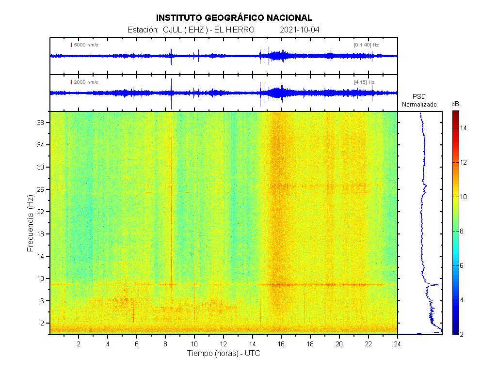
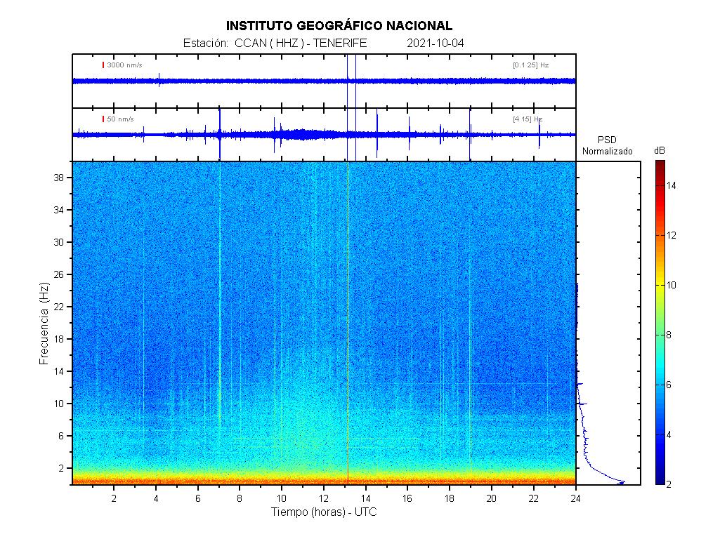
After this quake something seems stirring around on La Hierro, see https://www.ign.es/web/ign/portal/vlc-senales-sismicas/-/senales-sismicas/getDetalleDia?diadetalle=2021-10-04&estacion=HI01&tipoFO=1&tipoSP=1
The return of Bob?
checking the other islands….. WTF?

That is very strange
Im watching El hierro Graph and that happens days ago too. I dont know why.
Might be picking up the signal from La Palma? La Palma’s spectrograms sometimes picked up the activity from El Hierro in 2011 / 2012.
Both the LP03 and LP04 GPS stations show a very slight downward trend on the up axis. Can we use them to infer how long the eruption is going to last? See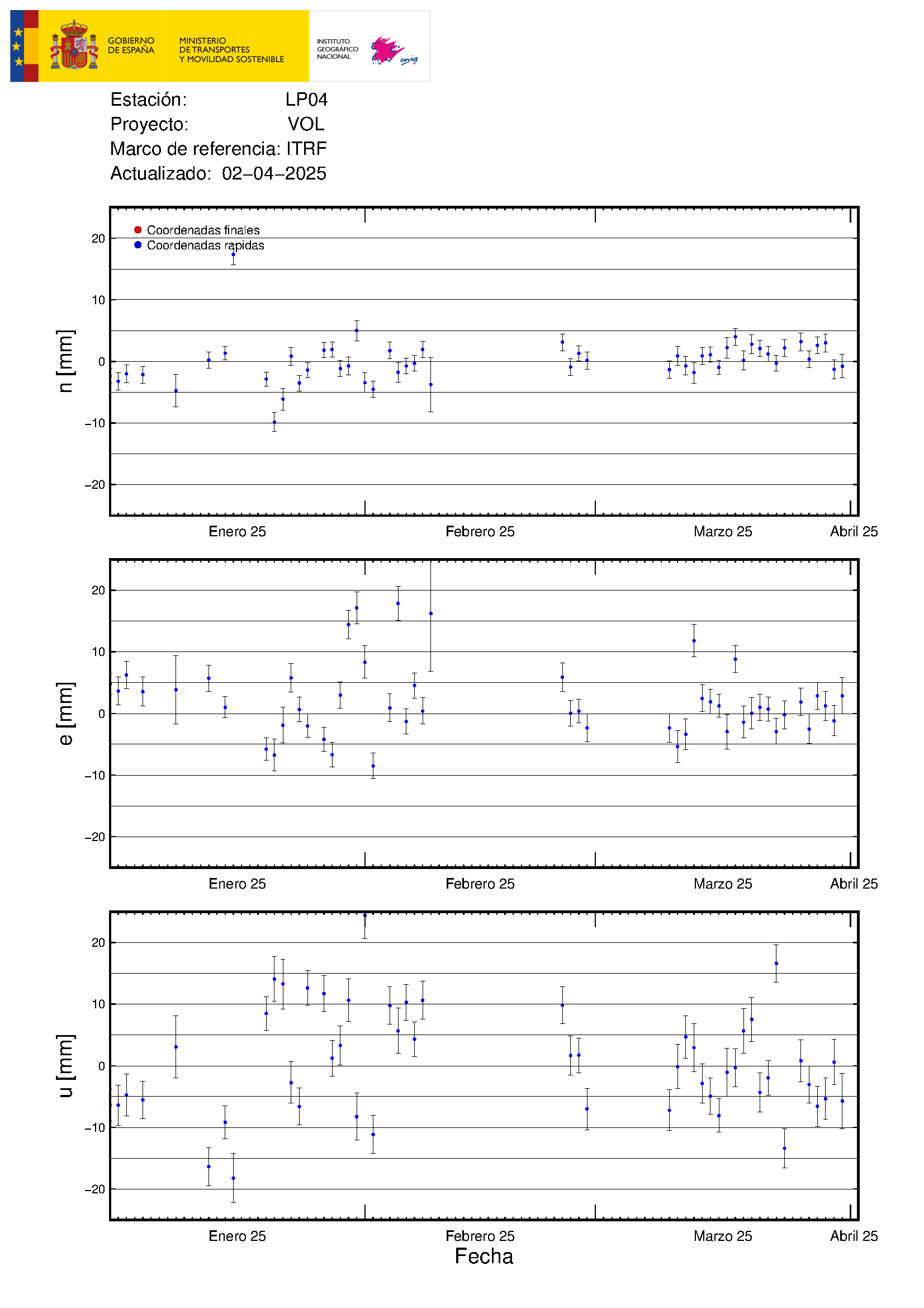 for example.
18:28 pm CET and the volcano seems to have switched to the 2nd vent (from the S) for main discharge https://www.youtube.com/watch?v=DFzZyTFQWo8&t=0s
I was thinking the centre of jetting had moved.
Maybe the other vent is blocked and so lava fountaining switched. I think there is still a lot of gas moving upwards and what we see is only the top of the whole batch. I fear that much more lava will be erupted during next days (weeks?).
Overall, this fountaining reminds me to a paroxysm at Etna, but at Etna the lava fountaining will stop after an hour or so and this continues and continues. What a power!
After going back over 3 hours of video, the volcano may have been trying to discharge on the southmost when I first started watching around 18:10 pm or so, but the vent now discharging at 19:43 pm seems to be the same one for the last 3 hours mainly. I am not sure what to think now.
Cumbre Vieja eruption is VEI 2 now…
https://twitter.com/VolcansCanarias/status/1445070998517264403
Anyone have any ideas on the smoking/degassing in Geldingadalir on the extreme left of this cam?
Could all these quakes in Reykjanes peninsula be sending a small amount of magma into Geldingadalir or is the eruption there really flat-lining?
Oops sorry link
*IF* that’s what I saw a few days ago in that location (when the cam was zoommed out more) it’s coming out of the lava field, and quite energetic. Looks to me to be more than just regular outgassing (such as we see in Natthagi).
My wild guess is it’s related to vents beneath the lave lake in Geldingadalir. My further guess is that there might be some low-level supply into Geldingadalir, because the lava pathway does not appear to be entirely closed (the sheer volume of gas we’ve seen in recent days seems to indicate that). I also spotted what I think might be moss fires around Geldingadalir a couple of days ago (I may well be wrong on that) on the RUV cam and a couple of frames of a drone vid (so scant evidence at best) which, if real, indicate a rise in the lava level in Geldingadalir.
I saw a report on the latest lidar overflight, that there was no new lava being produced. However deflation in the northwest corner was balanced out by small inflation in southern Geldingadalir, indicating a movement of the lava from one area to the other.
Thank you, Stars Die.
I hadn’t seen that, and it fits with what I think I saw; moss fires indicating a rise in level.
In the comments for the last article, I’d predicted that as a sign of renewed activity under the lave field, so when I thought I saw it occurring, I predicted an eruption was underway, and had been for at least 24 hours. That was days ago. What you’ve noted is a far more likely explanation.
I now hear a sound. “caw, caw, caw…” It’s my dinner calling. I just hope I don’t choke on the feathers.
Its going crazy…..
unbelievable!
what stream are you on? Tv Canaria is loud but voggy. Needs another hour or so for good visibility.
Gracias!!
What works best for me is to keep an eye on the YT homepages of TV Canarias and TV La Palma.
The current livestreams are always top of the list there.
https://www.youtube.com/channel/UCTQrUTmzCWIfG6h4EVCdOCQ
https://www.youtube.com/channel/UCY8cRUQNNGbEczTAA2NXhYw/featured
is there even anything coming of the lower vents? seems it all gas and tephra fireworks and the flow sources are getting buried for now.
All this in very short time…
4.0 mbLg N FUENCALIENTE DE LA PALMA.ILP
2021/10/04 18:58:51
12
+info
3.1 mbLg SW VILLA DE MAZO.ILP
2021/10/04 18:54:42
35
+info
3.2 mbLg NE FUENCALIENTE DE LA PALMA.IL
2021/10/04 18:49:17
10
It’s like watching some kind of runaway reaction and the whole cone will blow up any minute.
I’m wondering how special this really is this for a more experienced volcano watcher / seasoned volcanologist?
Sure appears that whatever is being stored in the furnace is making every attempt at getting out.
No idea, but this has to be the strongest eruptions yet, that stuff is going so high the cameras need to zoom out, lava bombs hundreds of feet in the air. Incredible fireworks.
One fears something exceptional might happen. Its out of control….
Like what for instance? Is there any way this could become more powerfully explosive and transition to a sub – plinian eruption?
I don’t well understand eruptions that change morphology in the midst of an eruption, but I gather that can and does happen?
21:25:14 pm CET very nice burst from the cone
https://www.youtube.com/watch?v=ngHMnPdjnR4 is an interesting view
Beats Peter Jackson 😉
Multi-stream again: https://www.youtube-multistream.fr/multistream.php?id1=_u49m6I5Mpw&id2=ATZY4wntQ0g&id3=ZV7MUfGs_1U&id4=ngHMnPdjnR4
Sometimes livestreams show “error”, which – may be is caused by many internet outages today!
Please refresh from time to time…
21:33:08 pm lots of smoke or clouds closing in closer to the camera than the vent. What’s up? fog? https://www.youtube.com/watch?v=DFzZyTFQWo8
Footage straight from hell I reckon! 😈
It looks like Mordor…
I thought I saw the Balrog from the Moria mines … he must be on vacation on La Palma.
And now seriously: This is terrible, for many people it is a great natural spectacle … but it is ruining businesses and families that have lost not only their possessions, but also part of their family history and memories.
Pity it much…
But that’s what’s history is about!
It also causes huge disruption indirectly. North-South connections on the west side have been cut. Taking the detour around the southern end of the island on congested roads adds hours to travel time. Imagine the consequences for commuters and businesses.
The distant view (as above) is still pretty impressive.
Canaries also another subject in news sadly…
Straight to hell – The Clash
https://youtu.be/t7SvtikTkrM
Randall! Use the multi window youtube channel, you just can see if there are clouds near the volcano. 😏
It is an mountainous island in the Atlantic. So clouds passing nearly every evening I guess.
https://twitter.com/RTVCes/status/1445120399583457288
#ErupciónLaPalma | The width of the lava flow has reached 1,250 meters in some sections
Scientists watch over it and monitor it for a change of course
seems to have been nice fountains from 11 hours ago to 3 hours agp – now it still ooks to be shooting out lots of ash but not much ‘flame colour’ visible anywhere
22:33 pm CET and it looks like lava is getting ready to roll, as perhaps the more explosive gases have released. https://www.youtube.com/watch?v=DFzZyTFQWo8
Increasing seismic energy is observed according to
@IGN_Sismology
concentrated in the center of the southern summit of the island. MAG.max.3.7. Prevalent depth 10-16km
https://twitter.com/VolcansCanarias/status/1445122746862686211
https://drive.google.com/file/d/1eNJ8yEO_4yB3xWhJl0KLaoFLawIlBxPA/view?usp=sharing shows that the sound being emitted from the volcano vents has two peaks, one at 47 hz and the other dominant at 77 hz. There is a hump in the very low freq around 4-5 hz, which probably accounts for the rumble which is felt by people.
22:51:41 on Afar. Quite a large ejection of lava bombs.
Nice single bang about 8 secs later at the microphone
23:33:02 pm CET another banger
23:36:26 pm CET another big ejection all over the place
Lava flow video
https://twitter.com/CSIC/status/1445108312027144193
23:34 pm CET has some serious venting and 3rd vent starting to come alive now
The last 15 mins ( 01 am ) the volcano has been making thump-thump sounds or a distinct bang-bang sound like hitting a bass drum twice. This is very noticeable and can vibrate the whole island.
About 1:49:25 am CET there was a noticeable burst, about the biggest I have seen so far tonight. Is the lava being thrown over a 1000 meters high?
Now there is two large fountains going off at once That’s pretty special- I take it that it’s not a common event-well atleast for La Palma eruptions.
I have to disagree on that one, so far its behaving like most of the historic eruptions in la palma and the other islands, fissure eruption with strombolian vents and effusive vents, for example in 1949 there were 3 different centers (hoyo negro, duraznero and llano del banco) separated several kilometres from each other and with different eruption styles.
This eruption is behaving similar but it is alot bigger, in only 2 weeks it is at least as big as 1949 and 1971 combined, both of which lasted about a month. 1949 also didnt have a high fountaining stage, 1971 did but not very consistently.
Would not really surprise me now if this ends up being a much more significant event. Maybe what happened on Lanzarote was not as unique as we think it was, and something similar happens now on La Palma. The real wildcard is the presence of so many magmatic quakesand the still relatively evolved magma even at this time, there is a lot of magma available. Earlier eruptions sometimes happened from multiple vents but there was only ever a single central vent, if we get another one of those forming a long way from the current eruption this is going to be big.
Its clearly more intense than the last 2 eruptions in La Palma, I am still surprised that we are getting tephrite for 2 weeks, thought that it would only be a small throat clearing early on before the more “fresh” magma comes up.
On another topic I would like to know how many Timanfaya like eruptions have happened in the canaries in the las 10k years by volume, (not counting Tenerife explosive eruptions) I can only think of the Tanganasoga cone in El Hierro, but there might be more
The Kilaūea summit crater eruption continues
Lava is so shiney and smooth! Like liquid aluminium. Kilauea can display very very low viscosities.. as fluid as Nyiragongo perhaps even more fluid than that. Hawaii is runny lava for soure
https://prd-wret.s3.us-west-
2.amazonaws.com/assets/palladium/production/s3fs-public/styles/atom_page_medium/public/thumbnails/image/multimediaFile-3326%20-%20edit.png
This eruption will last longer than the last one. That side vent is still going even with the lake flooding it now, and the other vent is in the lake itself. There is no chance for the pressure to fall so low it just stops. The deflation is also very weak now it might not even be there, so the activity today is actually base supply. GPS drop might only fall to the value of last August, maybe a month or two to recover, that is when the rift will finally build some real pressure and open up.
That cone is 20 meters tall too.
Yes the magma supply is crazy to Kilaūea these days
I wonder If the old lake crust will finaly melt..
Or is lava so insulating and haves so large heat and cold stoorage capacity .. that the old crust wont melt at all?
Will the old lake crust melt If this rootless lava lake gets deeper?
PS Whats the magma composition with lowest thermal conductivity?
Old crust could melt but it looks like the eruption isnt strong enough for that. Seems the lava could be receding below the old crust even, the lake as a whole is rising but the gas rich surface layer seems to be going away and might only persist at a few locations. Maybe the future activity will be spatter cones and lava ponds on top of a floating crust, with eventually more substantial flows out the edges if the lake rises high enough to overflow into the main caldera.
Not sure I would place bets on a 1 km3 lava lake being able to exist though, might be too heavy, likely to self destruct before then.
A ryholite magma maybe the best insulator?
While a Komatite maybe the worst?
But even a komatite is very insulating compared to common metals
Still basalt is an amazing insulator and heat storage
This rootless lava lake will never cool off before its either drained or destroyed by other eruptions
Kilauea Iki is still glowing inside I think althrough rain water circulation cooled it faster than expected
It does still steam a little when you walk across it.
Cumbre Vieja: Is still lava actively flowing into the Atlantic?
I lost a bit track of the different flows, are there any good and recent non-faked drone videos of the current situation there?
Copernicus isn’t gonna do the trick for me since it shows cold lava that’s inactive too.
Since yesterday (at least i don’t remember earlier) they start to get very deep quales like between 37Km and 33Km. Today there was several of this quakes…
3.1 mbLg S EL PASO.ILP
2021/10/05 06:50:38II
34
3.0 mbLg
NW VILLA DE MAZO.ILP
2021/10/05 06:27:59
30
3.3 mbLg W BREÑA BAJA.ILP
2021/10/05 05:58:57II
37
3.4 mbLg W VILLA DE MAZO.ILP
2021/10/05 04:18:43
37
2.8 mbLg
SW BREÑA BAJA.ILP
2021/10/05 03:47:25
35
is there any active rifting there? or with this depth, adjustment of the island on the moving atlantic floor?
And very energetic quake sequence in last hours…
3.9 mbLg SW VILLA DE MAZO.ILP
2021/10/05 08:29:25
11
+info
3.5 mbLg N FUENCALIENTE DE LA PALMA.ILP
2021/10/05 07:19:36
13
+info
3.4 mbLg NE FUENCALIENTE DE LA PALMA.IL
2021/10/05 07:10:36II
14
+info
3.1 mbLg S EL PASO.ILP
2021/10/05 06:50:38II
34
+info
3.0 mbLg
NW VILLA DE MAZO.ILP
2021/10/05 06:27:59
30
+info
3.2 mbLg SW VILLA DE MAZO.ILP
2021/10/05 06:10:03II-III
11
+info
3.3 mbLg W BREÑA BAJA.ILP
2021/10/05 05:58:57II
37
+info
2.5 mbLg
NE FUENCALIENTE DE LA PALMA.IL
2021/10/05 05:13:53
15
+info
3.4 mbLg W VILLA DE MAZO.ILP
2021/10/05 04:18:43II-III
37
https://twitter.com/VolcansCanarias/status/1445309839870251008
Its hard not to fear an eruption at the epicentre of these quakes, they are so localised, on the ridge line and could go either way.
Mo Chairde (Hi Folks),
Long time lerker, Seldom poster.
Could someone provide an opinion on what’s happening under La Palma over the last 48+ hours. While I’m not scientifically based I do know that the magnitude of these quakes, their depths and frequency are making me very uneasy.
The view was that magma was on the move. Does this indicate that the volume is significant/very significant? The depth of the quakes has ranged (roughly) from 10 km to a 34km. What is happening at 34 KM? Also, mag 3+ quakes are coming thick and fast.
I am untrained but know enough to be uneasy.
Mise Le Mheas (Regards)
Richie Lynch
Yes it’s true… they just told that it’s rising the possibility of +M4 quakes…
Luis, this person is watching the earthquake situation closely https://twitter.com/NaqNab/status/1445335387539443713
See https://twitter.com/NaqNab/status/1445043317364957186
Volcanoes are life (at least underwater). A Guardian article on the effects on marine ecosystems with links to science pubs.
https://www.theguardian.com/environment/2021/oct/05/volcanoes-are-life-how-the-ocean-is-enriched-by-eruptions-devastating-on-land
Its a bit hard to see through the morning mist, but the edifice is looking very steep for a pile of rubble.
A pyroclastic flow covering a significant area may be becoming a possibility.
In which case observers/security personnel in the town(s) may be at significant risk.
https://twitter.com/volcanodiscover/status/1445329996894162945
#La Palma #volcano eruption already biggest on the island in more than 100 years – The eruption continues without significant changes this morning, with lava fountaining at the main vent, ash rising a 2-3 km and slowly drifting sout…
https://twitter.com/VolcansCanarias/status/1445333675982401538
Volume of erupted lava was estimated at 80 million cubic meters last Friday, and now probably more in the range of 100-120 million m3, exceeding both the San Juan eruptions (1949, with 55 million m3 of lava) and Teneguía (1971, 43 million m3 of lava).
Just over 2 weeks to reach the same volume as the last two eruptions combined, which both lasted a month each.
Further down it says 250,000 tons of SO2 emitted, that sounds very low for the size of this eruption. Kilauea erupted that much every day in 2018 for at least a month if not the whole eruption, and just this week has erupted a total of about 140,000 tons, from only 11 million m3 of lava erupted.
Hawaii does have very high sulfur content in magma and perhaps an alkaline melt wouldnt be expected to be so high, but I expect it is more than a 5/1 ratio. Im not so sure alkaline in this case actually means the same thing as it does in chemistry either, so maybe there is no acid base reaction between the lava and SO2 in the first place anyway…
Has anyone come across any discussion on whether or not the first two southmost vents have coalesced into just one vent?
https://twitter.com/efadi_LP/status/1443141662834929672 is a tweet where a man named Roger urges that people use the name Vulcan Tajogaite for the name of the new volcano.
We’ve seen pictures of the gravity waves caused by Volcano Tajogaite but I just came across this and had to post https://twitter.com/NaqNab/status/1445339036948783104 as I have never seen this before ever in my life.
The atmosphere is a fluid … No doubt about that
Great find Randall!
Amazing. By now I think that the locals must be afraid.
For Quinabauron: https://twitter.com/MarcoDiemme/status/1445337457671741449 is a timelapse of the quakes near Keilir.
At 12:48 on the AFAR stream time stamp they zoom in on the effusive vent fountain. Then they pan down the flow off the lava down the cone.
https://twitter.com/AEMET_Izana/status/1445342330534436865
This morning the eruptive column of #VolcanLaPalma is clearly seen from # Izaña moving towards the southwest.
The top of the sea of #nubes is about 1500m above sea level and the volcano’s plume rises up to about 4500m.
Photos: Conchy Bayo
Subject: Length of Tajogaite eruption using a linear fit to GPS data
Summary: 8.68 years
Method:
I used the last 15 data points of the up axis on the GPS station LP03 to make a crude estimate of when the eruption might end. I assumed a simple line running through those 15 points.
Using gnuplot, the following equation was determined:
y = -0.196197005165013*x + 622.141853379437
with 0 being Sept 20, 2021 as the best fit line through the data
The equation will cross the x-axis around day 3,171, which is approx 8.68 years.
This strongly suggests that the eruption is going to be around awhile
And yes, this is a very crude estimate.
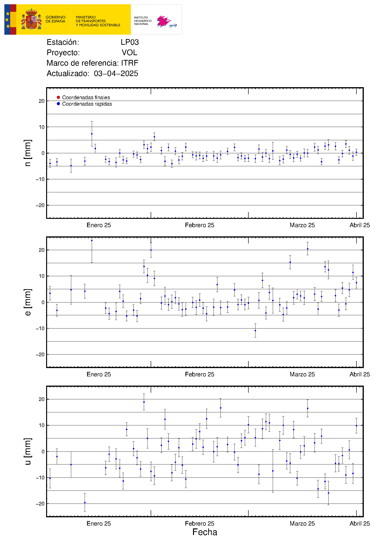
😁
Maybe you can use the Grimsvötn graph for a countdown. 😉
It does not fit exactly, but it is a good lead….
Whow, got a new face!
https://www.youtube.com/watch?v=INvrtMg5tSQ
13:54 a massive lava boulder comes rolling down the mountain. I couldn’t begin to estimate the size of the thing but much bigger than my house is probably accurate!
Has anybody seen any recent Lidar or tilt info on the Keilir area?
Closest GPS Fagradalsfjall and Oddfjell doesn’t show remarkable uplift or changes in trends.
Thanks
https://twitter.com/NaqNab/status/1445387767115100173
The ash volume has increased considerably
Surely not your fault 😀 but in what way is this possibly related to “Kilauea”? Or “Hawaii” for that matter?
Ok I see, both Tajogaite and Kilauea are volcanoes currently erupting. And why not relate “Hawaii” to it?
Just wondering why not write “Italy” since Etna is there, which in turn could then be further related to “Europe”. Heck even “#France” could be added since it is bordering Italy.
Sadly no one cares. And more hashtags means a broader audience and thus more clicks, which of course is the most important thing about a tweet/post.
3.6 mbLg SW VILLA DE MAZO.ILP
2021/10/05 13:57:06
37