The island of Vulcano (source: wikipedia)
The volcano helpfully called ‘Vulcano’, one of the islands, north of Sicilyhas give its name to all volcanoes in the world. Vulcano last eruption was in 1888-1890. During the long repose period, a settlement has grown from a few houses to villas and hotels. Frazzetta et al. wrote in 1984 (quoted by Boris Behncke)
“A volcanic hazard exists where there is the potential for loss of life or property as the direct result of volcanic activity. The major effects of all activity at Fossa are confined to within 2 km of the vent. The village of Porto with a population of about 250 inhabitants lies within this zone to the north of the main cone. During the summer the population of this town swells to more than 10,000. It is quite dangerous for a village to be located so close to an active volcano.”
The settled community has grown from 250 to 450 since 1984, and in August there may now be 12,000 tourists each day (Behncke, private communication). The location of this community so close to the crater has made Vulcano into the second most dangerous volcano in Italy, after only Vesuvius. And now the alert level has been raised to yellow. Luckily this is after the summer and the height of the tourist season. But we are concerned.
The following post is one from the archives. It was written by Henrik in 2013, and is well worth resurrecting. At the end, we also reproduce a description of past eruptions from the current crater, Fossa, based on an article by Boris Behncke and reproduced by permission.
Over to Henrik:

Fig 1. “The Thunderbolts of Zeus”. One of the amazing photographs taken by the incomparable Marco Fulle, often reproduced on the Internet without giving credit to this wonderful photographer.
Hephaistos, the lame son of Zeus and Hera, the King and Queen of the Hellenistic Pantheon, was the god of blacksmiths, artisans, craftsmen, metals, metallurgy, fire and volcanoes. He was also the weaponsmith of the Gods and crafted, amongst other things, the thunderbolts of Zeus.
Of course the Romans, the greatest copyright infringers ever produced by mankind incorporated the Greek Pantheon as their own religion and mythology. Here, Hephaistos was known as Vulcanus. The roman scholar Marcus Terentius Varro (116 – 27 BC) cites the Annales Maximus, which go back to at least 400 BC, as the source of the first mention of Vulcanus. He mentions that king Titus Tatius (d.748 BC) dedicated a series of altars to deities among which Vulcan is mentioned.
Perhaps more suggestive is the fact that a new eruptive centre formed in the strait between Vulcano and Lipari with the first recorded eruption occurring in 183 or 123 BC. The eruptions went on for more than a century, thus were contemporary with Varro, and formed a new island Vulcanello. This was volcanic creation of new land where only sea had been before and must have been considered by the ancient world as very significant proof of divine existence and omnipotence. In addition to its theological usefulness, Vulcano provided the Romans with wood, alum and sulphur, activities continued as the main produce of the island until the last, or rather, most recent series of eruptions of 1888-90 ruined the mining works. Today, Vulcano is home to some 500 year-round inhabitants while in the summer, the population grows to about 10,000. But not to worry, renewed activity will almost certainly be preceded by irrefutable signs of unrest well in advance of any potentially devastating event.
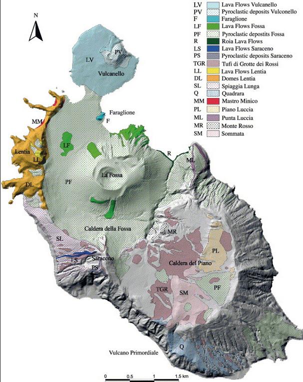
Fig 2. Geology of Vulcano (Gioncada, Mazzuoli, Bisson & Pareschi 2003)
The visual appearance of Vulcano is very suggestive with the most ancient centre of activity, the collapsed stratovolcano “South Vulcano” (ca. 120-98 kA) and Piano Caldera (ca. 98-97 kA) to the south, the Lentia Complex (15.5 kA) with the Lentia or Fossa Caldera (16 -13 kA) in which the new La Fossa cone (~6 to 5 kA) grew. To the NE of the Fossa cone an extrusion is obvious but no date has been given for it (14 kA Punta Roja lava flow?). Finally, to the north is the already mentioned Vulcanello complex (2.1 kA).
Activity at Vulcano began a mere 150,000 years ago and is divided into four major stages. The first, South Vulcano center, began at about 120 kA by building a trachybasaltic to trachyandesitic stratovolcano where pyroclastic fall and flow deposits constitute only a minor portion. The activity at South Vulcano came to an end with the collapse of the stratovolcano around 97 kA into the 2.5 km diameter Caldera del Piano. Interestingly, it seems that the caldera was formed, not by an eruption that led to a collapse but the collapse of the stratovolcano “for reasons unknown or unspecified”. Post-caldera activity continued for some 45,000 years which resulted in most of the caldera being filled by lava flows. Then there seems to have been a period of inactivity covering the next 30,000 years.
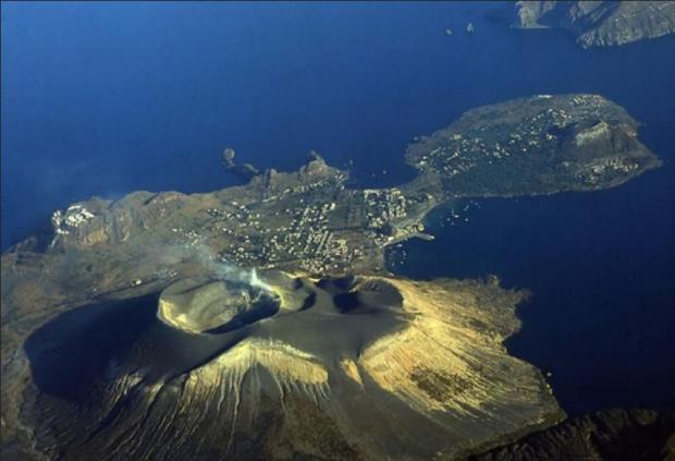
Fig 3. Looking north. An aerial photograph of the infilled Lentia Caldera with the Gran Cratere of the La Fossa Cone and island of Vulcanello
About 15½ thousand years ago, activity renewed at Quadrara and Spiaggia Lunga as well as the formation of the large rhyolitic to trachytic lava dome and flow complex of Lentia, the “Lentia Lava Dome Complex”, in the northwest. From somewhere in the strait between Vulcano and Lipari (proto-Vulcanello?) violent ash-flow forming eruptions occurred and deposited brown tuffs over a large area of the old Caldera del Piano to the south.
About 15-14 ka ago, another caldera collapse affected the island, this time in its northern part, forming the Lentia caldera. Again, there seems to have been no explosive eruption associated with the caldera collapse, which may have been “tectonically triggered”. Activity continued within the new caldera with at least five cycles of pyroclastic and lava flows, the most significant being the Punta Roja lava flow that crops out at the E base of the La Fossa cone. Eruptions also occurred from N-S trending fissures in the NW part of the older Piano caldera where the Alighieri formation and the edifice of Monte Saraceno were formed.

Fig 4. Inside the Gran Cratere of La Fossa (volcano.oregonstate.edu)
About 11,000 years ago, activity began to concentrate in the centre of the Lentia Caldera and at least four eruptive cycles formed the massive-looking albeit only 391 m high La Fossa cone. Over the past 2½ thousand years, there have been at least 15 confirmed eruptions with a further ten possible from La Fossa with the last terminating on March 22nd 1890.
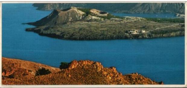
Fig 5. A post card of Vulcanello from Lipari
Although activity at La Fossa continues and cannot be said to be over, the last major eruptive period recognised is the already mentioned one that began in the second century BC and led to the formation of the Vulcanello Island and complex. Eruptive activity continued with at least two further eruptions after the initial, island forming series ended in ~10 AD. The final eruption, that of 1550, connected Vulcanello with Vulcano. The activity produced three overlapping tephra and scoria cones with craters shifting from E to W, and a gently sloping lava platform mainly on the N, W and S sides of the cone cluster. The Vulcanello products are generally more mafic than most other Vulcano eruptives, being of leucite-tephritic composition, only the most recent lava flow, Punta del Roveto of 1550 being trachytic.
HENRIK

Fossa, 2018. Source: Volcanodiscovery
Henrik ended his post with: For further reading, I highly recommend Dr Boris Behncke’s former site, thankfully saved for posterity by the Michigan Technological University
This site does not appear to exist any more. We reproduce here part of the content, describing the eruptive cycles of the Fossa cone over the past 6000 years. The text is slightly edited from the original. The images as shown here are available at https://slidetodoc.com/3-volcanoes-killers-and-creators-dr-daniel-barker/
The evolution of the Fossa cone, the most recently active volcanic center on Vulcano island, has been described in detail by Frazzetta et al. (1983) and briefly reviewed by Frazzetta et al. (1984) and Frazzetta & La Volpe (1991). The following is a summary from those sources.
The Fossa eruptive center developed only during the past 6000 years, after the presumably tectonically triggered formation of the Fossa caldera, about 14-16 ka ago. Its birth followed post-caldera effusive activity of which the 14 ka Punta Roja lava flow gives testimony. Activity of the Fossa cone has been divided into several cycles by Frazzetta et al. (1983, 1984) and Frazzetta & La Volpe (1991). The cycles have generally shown a characteristic succession of eruptive styles and each had an individual eruptive vent. Some cycles began with powerful vent-clearing explosions leading to deposition of “phreatic breccias” near the eruptive vents. The hydromagmatic initial stages of other cycles produced wet and/or dry surge deposits. Later products of each cycle show a decreasing influence of external water, the final products being fully magmatic (pumice-fall deposits or lava flows).
There is a complete lack of erosional surfaces and paleosoils between the products representing a cycle. It is assumed that activity during each cycle was more or less continuous. This contrasts with distinct erosional unconformities between the products of various cycles, evidence of longer repose periods separating different eruptive cycles.
Punte Nere cycle
The initial activity of this first recognized Fossa eruptive cycle was hydromagmatic and produced a more than 60 m thick sheet of dry surge deposits overlying the Punta Roia lava flows (14±6 ka). The basal strata of this sheet are composed of coarse and fine clasts and are overlain by sandwave and massive beds. Fragments of a trachytic lava flow that may have been ruptured by the eruptions and a thick block-fall deposit are present in the middle part of the sequence. A fall deposit composed of normally bedded and occasional reversely bedded layers with interbedded surge beds make up the uppermost pyroclastic unit of the cycle. It was followed by the emplacement of the trachytic Punte Nere lava flow that forms a delta-like feature on the N base of the Fossa cone. This flow was dated at 5400±1300 years.
Frazzetta & La Volpe (1991) estimate the volume of tephra produced during the Punta Nere cycle at 195 x 106 m3 and that of lava at about 3 x 10⁶ m3. The activity left a cone about 250 m high. The NE crater rim is still well discernible in the eastern part of the Fossa cone.
At least three undefined eruptive cycles occurred after the Punta Nere cycle and left wet and dry surge deposits as well as the Campo Sportivo lava flow (see the map of lava flows), on the NW base of the Fossa cone. That flow has a radiometric age of 4600±1700 years and thus falls into the same time window as the Punta Nere flow; stratigraphically, though, it lies in a higher position. The volume of the Campo Sportivo lava flow is 2.6 x 10⁶ m3 while that of the tephra presumably associated with it is 25 x 106 m3. The volume of tephra from the other undefined cycles is about 10 x 106 m3.
Palizzi cycle
Following a repose period of unknown duration, hydromagmatic activity led to the emplacement of wet surge deposits followed by dry surge beds. Accretionary lapilli in these initial deposits give testimony of a high water component during the opening stage of the cycle. Later activity produced a stratified, normally graded pumice horizon which shows evidence of a brief erosional interval at its top. When activity resumed, it was again hydromagmatic and deposited another set of basal wet and overlying dry surge horizons.
Like during the preceding cycle, the late stage activity was effusive, producing about 0.6 x 10^6 m^3 of trachytic lava that forms a narrow tongue on the southern flank of the Fossa cone (Palizzi lava flow, see the map of lava flows). The volume of all tephra emitted during the Palizzi cycle is given as 5 x 10⁶ m3. The age of the Palizzi lava flow is 1600±1000 years. This is well within the historic period but no correlation of the deposits with recorded historic eruptions of Vulcano is possible.
Comenda cycle
This cycle began with powerful explosive activity of which a basal breccia gives testimony. The breccia is composed of yellow hydrothermally altered clasts and is overlain by a pyroclastic flow unit with numerous fumarolic degassing pipes. The activity then shifted to hydromagmatic and produced wet and then dry surge deposits with abundant Pele’s hair (!) before it became again magmatic with the extrusion of the Comenda obsidian lava flow that is still partially visible on the SW flank of Fossa cone (see the map of lava flows). Its volume is 2.6 x 10⁶ m3, slightly more than one tenth of the tephra volume (25 x 106 m3).
Frazzetta et al. (1983) assumed that the upper and larger of the two Forgia Vecchia (“Old Forge”) craters was formed during the Comenda eruptive cycle. These craters are well distinguishable on the two photos below of the 1888-1890 eruption but have been subjected to intense erosion since then and are densely vegetated.
The initial activity (breccia and pyroclastic flow) probably occurred before the mid 6th century AD since these deposits are overlain by the white ash from the most recent explosive eruption of Monte Pilato, Lipari that is thought to have occurred around AD 550. The Pilato ash is overlain by the wet and dry surge deposits. Historic documents indicate that the emplacement of the Comenda lava flow may correspond to an eruption recorded for the year AD 785.
Pietre Cotte cycle
Initial activity was hydromagmatic, producing wet surge and soon after, dry surge deposits. A pyroclastic fall sequence (described as “pumice” by Frazzetta and La Volpe 1991) rests on top of these early products. The exact timing of the eruption’s beginning is not known but it is probable that one of its more peculiar events, the formation of the lateral Forgia Vecchia II crater (on the NW rim of Forgia Vecchia I crater), occurred in 1727. Twelve years later, lava seems to have filled the main Fossa crater and spilled over its low N rim, forming the obsidian lava tongue of Pietre Cotte (“Cooked Stones”) that is still conspicuous on the steep northern slope of the Fossa cone (see the map of lava flows). Its volume is 2.4 x 10⁶ m3.
Unlike other cycles, the Pietre Cotte cycle apparently did not end with the lava outflow. Following the effusive activity, eruptions resumed in 1771 and continued intermittently until 1890. All activity before the latest major eruptive episode, in 1888-1890, is not well documented whereas very detailed scientific descriptions of the most recent activity are available (see below).
1888-1890 eruption
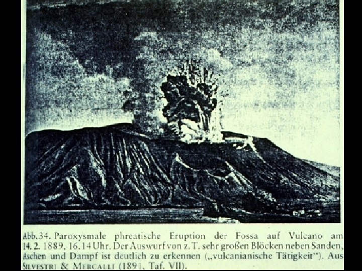
Photo of Vulcano in eruption, 14 February 1889. This view is of an explosion that ejects large bombs or blocks above a steam and ash plume. This photo was originally published in Mercalli & Silvestri (1891) and shows evidence of slight editing.
Vulcano last erupted in 1888-1890. Although it had erupted frequently in historic times, this eruption was the only one that was observed by scientists and was described in detail (Mercalli & Silvestri 1891). The activity observed by them was used for the introduction of a new scientific term, the so-called “Vulcanian” style of volcanic activity, now applied for powerful magmatic activity somewhere transitional between Strombolian and sub-Plinian.
The eruption was particular for the ejection of countless large breadcrust bombs. Meter-sized bombs fell in the area now occupied by the village of Vulcano Porto, on the crater rim they are much larger.
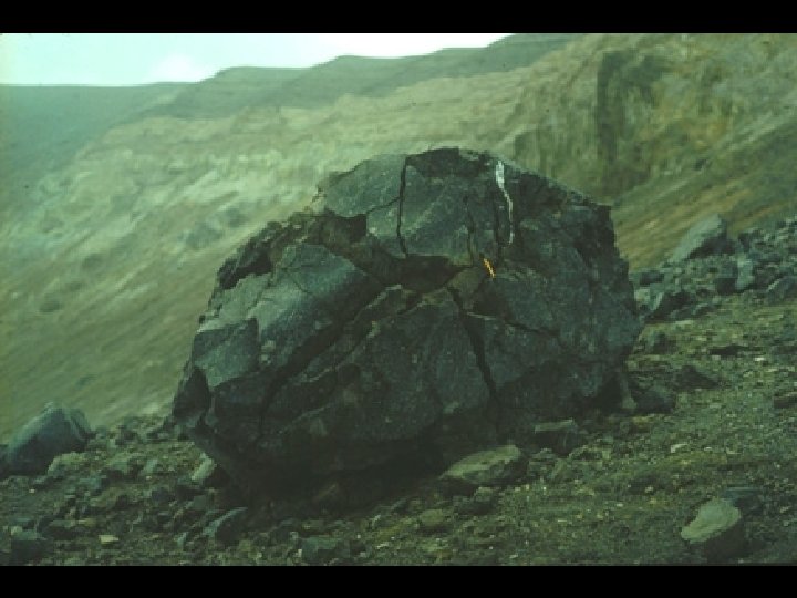
This is the largest of the famous breadcrust bombs ejected during the 1888-1890 eruption from Fosa Grande (the crater visible in the background). Giada Giuntoli is the person who gives scale. This bomb didn’t make it far away from the crater, but smaller ones fell abundantly in the area now occupied by the village of Vulcano Porto. 18 April 1995.
The buildings of the sulfur mining company located at Porto Levante were heavily damaged by falling tephra already during the first days of the eruption (starting on 3 August 1888), their residents could escape without fatalities or injuries. Later eruptions caused occasional ash and rare lapilli falls at Lipari. No major damage was done there, but the area now occupied by the village of Vulcano Porto was subjected to heavy bomb and lapilli showers.
The eruption ended on 22 March 1890, after gradually declining for several days. There were repeated unconfirmed reports about eruptive unrest at or near Vulcano, but no significant eruptive activity took place after 22 March 1890.
With the 1888-1890 eruption, the Pietre Cotte cycle seems to have come to a close. The volume of tephra produced during the entire cycle is given by Frazzetta & La Volpe as 25 x 106 m3 of which the 1888-1890 products do not make up more than one fourth.


Kilauea is now at Orange watch down from Red.
On AFAR at around 15:50. The effusive vent is moving huge boulders down the lava stream.
White clouds on La palma volcano. Water inyection?
I guess this piece by Henrik was inspired by the property loss on the Isla de la Palma. The settlement of Porto is really quite close to Fossa, and those “bombs” don’t seem to be very reassuring. In summer it might be a problem to evacuate everybody on time.
As there are 15 assumed eruptions in 2.500 years an eruption in this century, esp. the first half seems to be possible. I hope there is decent monitoring.
Aside from that this was an interesting piece by Henrik, good to recirculate it. Thanks.
https://twitter.com/NaqNab/status/1445393002491531267
At around 35s on the rigth hand side, it looks like it’s feeding a lava tube: the flow above a point is greater than that below.
WOW!
https://twitter.com/NaqNab/status/1445430417142726656
More earthquakes and of greater magnitude: 75 in the last 24 hours, 17 senses.
https://twitter.com/ita_dc/status/1445428550325215241
Detail of lava fountain
I have to say I am beginning to feel uncomfortable that something really drastic might occur. At some point wider evacuation may be appropriate, possibly soon.
I am feeling the same anxiety. I think Los Llanos should be evacuated. If I’m not feeing comfortable the people living below must be feeling 100 times worse.
If it were me I’d be waiting for the first flight out from Santa Cruz airport tonight.
Perhaps not only Los Llanos. There is earthquake activity to the east of the ridge, too, albeit relatively deep (when I last looked).
Hope they have enough monitoring in place.
Me too…
Tuesday
05.10.2021 16:14:10 63.931 -22.182 5.4 km 3.5 99.0 1.3 km SSW of Keilir
The quake swarm is diminishing in numbers (based on the total in 48 hours on vedur.is), which has declined from over 300 to under 200.
However, the shallowing trend seems to be continuing. So, I wonder if the shallower depth is causing fewer quakes, or, is the force behind it diminishing?
Does anyone have any thoughts on how shallow the quake swarm would need to get before an eruption is likely? As I recall from back in March, at around one km or so, people started saying an eruption was imminent (and they were right).
https://twitter.com/AbdulsatarBoch1/status/1445438750591422475/photo/2 shows that the Montana Quemada lava flow lasted 22 years 1470-1492, on La Palma
I’ve been trying to find information on that Montana Quemada eruption, though no luck so far. I can’t determine whether it erupted in 1470 and again in 1492, of erupted between those years too.
My current guess is it was not a continual eruption, otherwise the lava would have reached the sea.
3.5 mbLg SW VILLA DE MAZO.ILP
2021/10/05 18:37:01
36
Is the intrusion of quakes towards San Pedro new? I am not aware of this trend?
Is it a big lava flow I am seeing on the mbl.is Keilir close up cam at the moment?
Please post the link
That’s Reykjavik. Bit of a melting pot…
Iceland: Keilir
I see MBL are exceedingly confident about Keilir. So much so they turned and zoomed their webcam to it and announced a new live stream. Do they know something we do not? 🙂
One thing we can be sure of – this Samsung camera won’t need a warranty against being overrun with lava.
Here’s the link: https://www.youtube.com/watch?v=3ht_Pmviamg
Thank’s!
Thanks Clive. False alarm
Perhaps they are looking for signs of an eruption, based on the location of the current swarm?
The Kelir webcam is focussing on an area just south of the mountain
https://www.livefromiceland.is/webcams/keilir/
In the stream https://youtu.be/myYRAQ4X-24 Tajogaite is looking more like a steel furnace than a volcano, once again.
While certainly a spectacular view, it is presumably relatively far from the truth. I still go with my 900 °C, other than the 1300 °C it is looking like.
Would be more like 1100 C, certainly well over 1000 by now with how fluid the lava is. If it was still 900 C it would be massive viscous flows, like the first few days, but the lava flows like a river into the ocean now, at least half way as an open glowing lava channel.
Fagradalsfjall isn’t completely dead yet; looking at a “run” of http://brunnur.vedur.is/myndir/webcam/2021/10/05/webcam_borgarfjall_natthagiNNA.html there’s clearly still stuff coming down into Natthagi, albeit not a lot. Nothing visible in daytime, but rather more than glow at the crater and on the flow down visible both from midnight and currently. Obviously small beer compared to the deadly fireworks of La Palma, and probably nowhere near enough to relieve the pressure growing in the dyke, but it’s ongoing.
Thats resudial heat from the eruption
Lava is a great insulator.. it will glow like that for many years
I thought the same exact thing, but it was pointed out to me by several people that this is residual heat and the article below points out that lava can redistribute itself even after an eruption stops.
Article on Geldingadalir’s lava redistribution https://www.ruv.is/frett/2021/10/04/a-thousand-quakes-but-no-erupting-lava
digital image done today by INVOLCAN so we’re down to just 2 vents now as of Tuesday Oct 5, 2021.
See https://twitter.com/Pg_Scarlato/status/1445102440706199556
https://drive.google.com/file/d/1eb0QO-GfXtdPgRy9cu5FDmtroQjERR-6/view?usp=sharing
As of 10:35 pm CET, 2 points of light stay on, on the east side of Tojogaite. Any ideas what they are?
Someone braver than I. 😳
Amazing view in visible and near infrared by Planet satellite:
https://twitter.com/planet/status/1445510755277697035
Yikes, Taal sure is pumping out the SO2 today, in July it peaked at 22,628 tons but today it’s reached 25,456 tons and it’s not even erupting!
https://www.rappler.com/nation/phivolcs-taal-volcano-advisory-october-5-2021-7pm
Depressurized hydrothermal system? Probably also a large shallow intrusion on the ring fault, like in Hectors article a while back. If the lid breaks then we get lava fountaining out of the fault, probably mile high ashy fountains, and all the water could make things dangerous. Inherently this is not dangerous, Kilauea is exactly the same when it has a caldera collapse, Taal might even be a smaller example, but the location makes everything and Taal is in a very bad location…
No inflation, no silicic magma, not even a massive volume or VEI number, yet potential for one of the worst disasters this century… Taal is being treated like Pinatubo, that is not at all a good analogue, that makes this a very big problem.
Why doesn’t Taal have silicic magma? I thought all volcanoes related to subduction processes, such as throughout the Ring of Fire, have that dangerous silicic/felsic magma, in the same way Krakatoa/Pinatubo do?
But I’m a layman who clearly doesn’t know the geology of Taal, or the Ring of Fire in whole for that matter. 🙂
The volcanoes in subduction zones are indeed quite dangerous, although this is due to a combination of factors: the steep slopes of stratovolcanoes, the high gas (water) content of the magma, and the silicic magmas that are often present. Basalt can still show up in most subduction zones though. In fact some subduction zones like Vanuatu are almost entirely basalt. It seems that the lava increases its silica content when it gets stagnated in continental crust, so the thicker this crust the more abundant silicic types will be, even if some basalt still gets through it.
Krakatau erupts basalt on occasion, too. It depends on if there’s any old magma for the new rising basalt to mix with.
Masaya is fantastic for a Subduction Zone Basalt
Almost as fluid as Hawaii
And 1160 C for Masaya.
Masaya produces also nice peles hair wool thats steel grey
It rises quickly from the mantle slab source without much evolving..
Chad, Taal is inflating, Phivolcs won’t mention by how much but they do mention the inflation. “Based on ground deformation parameters from electronic tilt, continuous GPS and InSAR monitoring, Taal Volcano Island has begun inflating in August 2021 while the Taal region continues to undergo very slow extension since 2020.”
Well this along with Vulcano (spell check doesn’t like that word but they are apparently not watchers of things volcanic) and Cumbre Vieja have certainly changed the game. Much for us volcano watchers to monitor. Let’s hope it doesn’t get worse than La Palma which is bad enough for people. Taal could be much worse.
New NASA picture of the Cumbre Vieja eruption:
with the rising ash and steam clouds forming concentring rings higher up in the atmosphere.
More details can be found here:
https://earthobservatory.nasa.gov/images/148924/ash-and-cloud-rings-over-la-palma
looks like the volcanos “finger print” xd
I posted a ground view (loop) of the same phenomena a couple of days ago.
Interesting that the atmospheric conditions have remained so stable.
Pretty cool stuff…especially from a meteorological standpoint.
In many ways, not that much different than the pyro-cumulus/cumulonimbus clouds/storms that developed this Summer over many of our devastating wildfires here in the western U.S. .
When the plume/cloud hits a “cap”, it spreads out in waves depending on what’s burning below.
This morning there have been two earthquakes one at only 9km depth and one at only 8km depth
2.5 mbLg SW VILLA DE MAZO.ILP 2021/10/06 02:25:55 8
2.5 mbLg SW VILLA DE MAZO.ILP 2021/10/06 02:07:03 9
This morning there was a M3.7 at 05:57 shown on IGN but it was then changed to a M3.3 with a different depth and even the position was changed . How can this be ???
3.7 mbLg SW VILLA DE MAZO.ILP 2021/10/06 05:57:44 11
REVISED DETAILS
3.3 mbLg NE FUENCALIENTE DE LA PALMA.IL 2021/10/06 05:57:44 II-III 14
http://www.ign.es/web/resources/volcanologia/tproximos/canarias.html?fbclid=IwAR3GEqfr-AJg4p18QS_fWpPmSxss6-_xwEAQJjv-33JqoKCac_KxSOqQ0A8
Another example M4.1 2021/10/06 07:25 SW VILLA DE MAZO ILP 40 ign.es
Now changed M 3.5 NE FUENCALIENTE DE LA PALMA.IL 2021/10/06 07:25:47 33
http://www.ign.es/web/resources/volcanologia/tproximos/canarias.html?fbclid=IwAR3GEqfr-AJg4p18QS_fWpPmSxss6-_xwEAQJjv-33JqoKCac_KxSOqQ0A8
changed earthquake size and 3D position are usually the difference between an ‘automatic rough calculation’ followed up by an expert assessing doing the calculation properly (they tend to do that for interestign quakes – everything auto assessed to be bigger than a certain size) and getting a more accurate result. I presume that’s what you’re seeing here
Thank you for the explanation.
New cracks that opened uo further northwest, so far with only gases and heat: https://youtu.be/4lg80JCCv4k
Magntude 4.6 earthquake in the Pahala Swarm with M 3.6 aftershock.
M 4.6 – 8 km ENE of Pahala, Hawaii – 2021-10-06 06:36:56 UTC – 32.69 km depth
M 3.6 – 8 km E of Pahala, Hawaii – 2021-10-06 06:39:24 UTC – 31.78 km depth
Robin Lacassin
@RLacassin
·
6m
A drone flight from the lava delta to the volcano erupting vents in La Palma, Canaries Down pointing backhand index
Volcano Las nuevas imágenes a vista de dron del delta causado por la lava del … https://youtu.be/EzOgUIijav4 via @YouTube
Just had a look at our old friend in Iceland- for the fist time can’t see any smoke coming from the vent- I wonder if it is really over for it.
Might just be the light / weather conditions; there is some gas still being emitted.
It looks like the Keilir swarm is moving a bit southwest, away from Keilir. Too tough nut to crack maybe? The depth is similar as before. It has gone up just a little bit and is now focused around 5.5km. I get a feeling that the intensity is tapering off. Either the swarm is starting to run out of steam, or it’s just building up to another M4+. I still haven’t seen any InSAR images or other deformation data to indicate whats actually going on. Have you guys seen anything?
I’ll answer myself: InSAR measurement came back with no psychedelic fringes. No ground deformation detected. This means there’s no shallow intrusion of new magma. It does not rule out deeper magma accumulation, so keep watching the area.
https://www.facebook.com/425701797497389/posts/4532758946791633/
Interestingly, there seems to be heightened tremor activity in the cascadia. I suspect it is probably seismic, but the swarming has been going on for about two to three weeks.
Could this be the start of something preceding an eruption?
Most likely deep harmonic tremor.
A pretty regular occurrence.
I noticed it looked a bit high on the PNSN site, but then again it was like that in Dec 2017/2018 if not more apparently.
Might be interesting: La Palma island (Spain)
Geothermal system revealed by 3D magnetotelluric data inversion
Source: https://d-nb.info/1222813882/34
Figure 4 quite interesting.
Graphs in here might also be of interest. article has no free access, call that science – I call it business:
https://www.researchgate.net/publication/285543824_238_U-_230_Th-_226_Ra_Disequilibria_Constraints_on_the_Magmatic_Evolution_of_the_Cumbre_Vieja_Volcanics_on_La_Palma_Canary_Islands
https://www.researchgate.net/figure/Map-of-the-Cumbre-Vieja-rift-on-La-Palma-showing-the-sample-locations-of-this-study_fig1_285543824
That vertical rift zone seems cross the two southern thirds of the island here from Fuencaliente to Santa Cruz de la Palma, in other publications it is shorter.
Daily Mail article and pictures of La Palma eruption ..
https://www.dailymail.co.uk/news/article-10063945/The-eruption-ripples-sky-Thermal-blast-La-Palma-volcano-seen-clouds.html
The paper quotes PM Sanchez inviting tourists saying La Palma is a safe place. That’s typical political talk (BS). We’ll see. Those earthquakes make specialists here on VC wonder. And VC is not a scaremongerer.
So, when did the Daily Fail say the megatsunami will be? 😀
I’m intrigued by the RUV Langihryggur Iceland webcam live at the moment (Island timestamp 12:15).
What on earth is happening?
Someone’s parked a rusty old van in front of it. Interesting alternative take on the usual tourist selfie.
Back to normal now! One dead volcano 🙁
Earthquakes are migrating SW from Kelir. It may just be having a nap.
It would be interesting to see a time-lapse video of the Lave Delta growth. I don’t have the skills ( sigh ! )
In the piece one down from space dot com it says the new peninsula has a size of 25 soccer pitches.
How many Olympic Swimming Pools is that?
Ha ha!
Heavy ocean entry live from La palma, Spain
Entry on Playa Nueva near Tazacorte, this piece says:
https://www.researchgate.net/figure/Map-of-the-Cumbre-Vieja-rift-on-La-Palma-showing-the-sample-locations-of-this-study_fig1_285543824
Was wrong link, happens when to many tabs are open and I hit the wrong one:
https://www.space.com/la-palma-volcano-lava-reaches-ocean-astronauts-satellites-photos
Thank you for that.
This answers my question some time before, whether the lave is still actively flowing into the ocean.
Things getting a little “wet” looking on the Faf seismograph
And the tremor is climbing again, at what seems to be an accelerating pace and with the blue about to cross to above the green.
Could be burbling lava again in just a few hours …
https://twitter.com/NaqNab/status/1445784607941615618
– Eruption is still considered strombolian (PEVOLCA quoted below)
– Small, far vents produced a lot of white steam clouds from groundwater, but volcano is at 1000m.
– Scientists (as of today) are not expecting new vents to south, but expect eruption/lava to continue
Iceland. Keilir. I’m stretching my neck out here and suggesting the rock-cracking phase may be reducing because magma is now on the move.
It’s hard to determine due to the lack of local stations at the hill but nearby ones are showing some signs of fluid movement and tornillos. Recent fractures were in the 5-3km depth.
Sadly the tremor charts are still vibrating to Fagradalir, helicopters, traffic, passing comets, and the weather so aren’t of much use.
Watch this space. My predicted date was 9 October!
I agree, lava seems to be moving towards Fagradalsfjell area again and is a bit closer to the surface today. There are many more quakes, but they are smaller which indicates that lava has easier to move now.
Could it be that the obstruction actually was close to Keilir, where the lava intrusion is expected to be (according to the maps from March). In that case, the move back to Fagradalsfjell might be a piece of cake…
I see we’re back to 3 vents again at Tajogaite. Interesting that the vents exhibit modalities, and all 3 went to venting gray smoke with not high velocity jetting early this morning. When explosions were occurring from vent #2 (I number the vents #1 as the southmost vent) vent #3 was bubbling lava mostly and vent #1 seemed shut down. Since gas pressure drives the eruption, it is interesting to watch how changing pressures affect each vent.
Just found this posted on FB:
 ?_nc_cat=110&ccb=1-5&_nc_sid=8bfeb9&_nc_ohc=UNq1sGJEh8YAX9N7Dbg&tn=r14-5Y3nEOAEADB7&_nc_ht=scontent.fdub4-1.fna&oh=37c2426793c2aca585b12b2840e5d331&oe=616349D0
Quite some change!
Hmm, guess I’ll have to steal it and link to that. (WP stripped most of the image URL).

Just look the steam from lava fan…
Not off topic, but something different to watch about these islands.
What a beautiful documentary, thank you for sharing!
Are you hallucinating or something? All it says is “This video is not available”. In fact there’s been a lot of that around here lately.
Works for me, Twisted One. I’m in the UK.
I guess it is not available in all countries. I have found that with some videos.
https://twitter.com/TheWatchers_/status/1445809715498213377
Major explosion at Stromboli volcano, significant amount of pyroclastic material, Italy
The third Italian one this year, or have I missed something?
Add Canary Islands & Iceland & Hawaii and…
Are we going into an active volcano period again? The 20th century was very calm comparing to the ones before…
I think we are entering an active period of interest in volcanic activity. The reported number of active volcanoes throughout history has been ever increasing with increasing population and with improving technical means to observe volcanoes, but that doesn’t mean that volcanism itself is increasing. Here’s some really interesting reading on the topic:
https://volcano.si.edu/faq/index.cfm?question=historicalactivity
Note that the reported number of large eruptions (VEI>=4) is fairly constant, since these eruptions are large enough that they rarely go unnoticed, even if there happens to be a raging world war going on.
Focusing on the last three decades, there’s more detailed data available here:
https://volcano.si.edu/faq/index.cfm?question=eruptionsbyyear
Note that between 50-80 volcanoes are erupting each year. Just because a few of them happen to occur in western countries, with plenty of instrumentation and a good supply of webcams and drone operators to cover the event, it doesn’t mean that we’re heading towards heightened volcanic activity.
Well, maybe in and around the Atlantic Ocean. For the rest I agree.
But basically, if we count the Caribbean and the Mediterranean as side arms of the Atlantic Ocean there seems to be more going on than in the past decades.
Instead, aside from Hawaii the Pacific Ocean has been relatively quiet this year.
Don’t forget that more eruptions are reported internationally now because of aviation and the internet. Firstly, planes are in a good position to report remote eruptions, and ,secondly. they need to know to avoid the ash clouds.
Not to forget La Soufrière St.Vincent and Nishinoshima
From the IMO translated by google translate:
The latest satellite data from Sentinel-1 (InSAR) from the Keilir area showing changes in the area from September 23 to October 5. There are no signs of changes in the earth’s crust in the area of the earthquake that has been going on since the end of September. The red lines delimit lava flow from the eruption sites.
No clear signs of land movement at Keilir
6.10.2021
The latest satellite data from Sentinel-1 from the area near Keilir show no clear signs that magma is breaking its way to the surface. The latest image, which shows changes in the area from September 23 to October 5, shows no signs of changes in the earth’s crust in the area of the earthquake that has been going on since the end of September. However, this does not preclude magma from moving at such a depth that it is not visible in satellite data.
“We have been running models based on the latest earthquake and survey data and the models indicate that if magma is accumulating, it is not in large quantities and at a considerable depth, or more depth than was seen in the run-up to the eruption in March.” , says Michelle Parks, who has worked on the analysis of the data together with Vincent Drouin at the Icelandic Meteorological Office. “If magma is building up to a depth of more than 5 km, but the seismic activity in the cluster is mostly at a greater depth than that, then it will not be visible on satellite images until a considerably larger amount has accumulated. It is therefore necessary to continue to monitor closely the development of the activity at Keilir “, says Michelle.
[This notice is not on the English version of the IMO webpages]
As written earlier, it seems like the lava is moving again with more and smaller quakes that are a bit higher up and moving in the direction of Fagradalfjell. The future will tell…
3.7 mbLg SW VILLA DE MAZO.ILP
2021/10/06 18:56:43
37
Its been revised.
3.3 mbLg SE FUENCALIENTE DE LA PALMA.IL
2021/10/06 18:56:43
25
Now showing.
3.7 mbLg SW VILLA DE MAZO.ILP
2021/10/06 18:56:43II-III
37
+ info
Maybe someone can make the 3d model and we can carefully watch the 3d traces of these quakes to see if we can make any sense from this?
YEAH!!! Found it!
See https://lapalma.maps.arcgis.com/apps/webappviewer3d/index.html?id=d9e690459e9e49ad94c845ac1b37e19c
shows a 3d map of La Palma and the earthquakes
[won’t work in the Brave Browser, okay in Mozilla Firefox]
https://twitter.com/NaqNab/status/1445735844178894851
Early morning yesterday Oct 5th from the Observatorio del Roque de los Muchachos north of the eruption site
https://www.youtube.com/watch?v=3ht_Pmviamg
I have been watching this cam for around half an hour and I am wondering if that is a puff of steam showing at the base of Keilir on the left hand side? Most likely I suppose to be a drop of moisture on the lens but still it is intruiging me.
There is something there.. A line of something like steam, changing over time!
Lens flare from bright object just above
Impressive quake sequence in just one hour and between 10Km and 13Km…
3.5 mbLg SW VILLA DE MAZO.ILP
2021/10/06 22:54:44
10
+info
3.6 mbLg N FUENCALIENTE DE LA PALMA.ILP
2021/10/06 22:50:30
11
+info
3.4 mbLg SW VILLA DE MAZO.ILP
2021/10/06 22:45:40
11
+info
3.9 mbLg NE FUENCALIENTE DE LA PALMA.IL
2021/10/06 22:42:04
S
13
+info
3.1 mbLg NE FUENCALIENTE DE LA PALMA.IL
2021/10/06 22:37:01
11
+info
3.4 mbLg NE FUENCALIENTE DE LA PALMA.IL
2021/10/06 22:11:56
11
+info
2.8 mbLg
NE FUENCALIENTE DE LA PALMA.IL
2021/10/06 22:10:41
11
+info
3.3 mbLg NE FUENCALIENTE DE LA PALMA.IL
2021/10/06 22:00:27III
11
yes, I see that and the magnitude slowly getting a big bigger. Can we conclude that lots of magma is getting primed to hit the pipes soon?
I think so…
the FAF chart is trending up, which it’s not done for some time, different to the spikes from the Keilir quakes. I live in hope that we’ve not seen the last of Fagradalfjall !
Strong wind today here in Iceland, that is the most likely reason why you see the chart trending up.
4.3 mbLg SW VILLA DE MAZO.ILP 2021/10/07 11:17:10 35 +info
3.3 mbLg NE FUENCALIENTE DE LA PALMA.IL 2021/10/07 11:05:08 14 +info
3.4 mbLg NE FUENCALIENTE DE LA PALMA.IL 2021/10/07 10:41:04 12 +info
earthquake sismicity continue increase on la Palma.
Apologies did not see you had already posted .
4.3 mbLg SW VILLA DE MAZO.ILP
2021/10/07 11:17:10
35
Actual situation on la palma