Apologies, a post about Ambae was due today, but it’s been put back to next week now (hopefully).
Originally written by Carl back in January 2014, this is a repost from the archives.

Lake Atitlán. Image from Wikimedia CC.
Though I walk through the valley of the shadow of death, I shall fear no evil
It is said that within great beauty lies grave danger and few places are more beautiful than Lake Atitlán. Poets have filled cheap notebooks with particularly flowery hyperbole in their attempts to catch the beauty of the caldera lake and the encircling volcanoes roaring out of the lake mist, catching fire as the morning sun hits them turning the green into imaginary gold and fiery red. It is truly a place of dreams, and as with every dream there is a spot of darkness hinting at a lack of a sign: Beware! Here be Dragons.
I rarely write about supervolcanoes. To date I have only covered two real supervolcanoes. The first was the perfectly balanced volcanic system of Tondano and the second was the rather comatose Yellowstone. I have though on occasion mentioned that some volcanoes have better PR agents than others. Where Yellowstone in its dying shroud sprouts a scientific volcanic paper a month, the rest of them will be happy to merit one per year for all of the known supervolcanoes.
It is sad that things are like this, but it is in the end hard cold political facts running science. Yellowstone will get you money to write a pointless paper and it is all about the number of papers, not the quality or merit of research that runs academia in the twenty-first century.
In the end it might not matter that much, the main reason I do not write about supervolcanoes is that they are such a boring bunch. After all, they very rarely do anything interesting, and when they do they either suffer a side vent eruption like Tondano, calmly inflate like Uturunku, or do a bradyseism and goes back to sleep. Or they do nothing and get papers written.
So let us get back to the matter at hand, the rather interesting Lake Atitlán.
A brief background

Who put a small roof in the lake? Photograph by Dr Carmen Morataya.
Lake Atitlán as we see it today is the result of activity after the 300 cubic kilometer Atitlán III eruption that happened 84 000 years ago. In the wreckage of the caldera collapse, the volcano started a new cycle towards yet another major explosive event, by the rapid serial construction of 3 major volcanic edifices, one after another and each of them built more rapidly than the previous.
The oldest of the 3 volcanoes born after the Los Chocoyos caldera event is the 3020 meter high Volcán San Pedro. It was built during 44 000 years of eruptive activity ending 40 000 years ago. After that volcanic activity started at the Volcán Tolimán which in the next 30 000 years grow into a 3 158 meter high edifice.
On the flank of Tolimán is the failed volcano of Cerro de Oro that might have erupted 5 000 years ago. Instead the new main volcano was born on the rim of the old caldera instead of within it as Volcán Atitlán started erupting 10 000 years ago. This volcano grew very rapidly and matured into a classic 3 535 meter stratovolcano.
In historic times Volcán Atitlán is the only erupting volcano in or near the Atitlán Caldera. The volcano suffers mostly from small to medium sized explosive eruptions. In the 384 years between 1469 and 1853 the volcano suffered 12 eruptions ranging from VEI-2 to VEI-3, but after 1853 the volcano has gone into a dormant state without any obvious signs of a pending eruption.
The area is highly seismic and in 1976 the area was struck by a M7.5 earthquake that killed 26 000 people. The earthquake most likely fractured the bottom of the lake and within a month the lake water level dropped two meters. It though rapidly filled up, most likely due to later seismicity closing the fractures.
The Lake
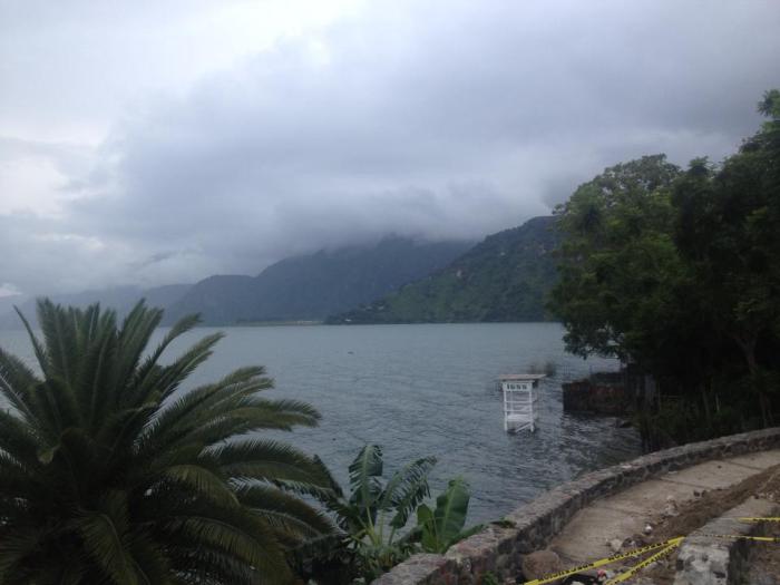
We all want lifeguards in the water, but lifeguard-towers? Photograph by Dr Carmen Morataya. Notice that the water level has under-mined the stone wall.
Lake Atitlán is more than 300 meters deep and is covered with a 300 meter deep layer of sediments. The sedimental layer is filled with prodigious amounts of methane that effectively hinder analysis of the actual caldera bottom 600 meters below the surface.
Sedimentation occurs with a normal rate of 0.5 centimeters per year, and that accounts for half of the 20 meter uplift of the water level in the last 2 000 years. We know the rate of uplift from C14-dating of artifacts found in a sunken Mayan village.
The lake is suffering from extensive deep hydrothermal activity releasing large amounts of energy (290mW/h inside the lake and 230mW/h outside), this creates an ideal environment for the silt producing cyanobacteria inhabiting the lower two thirds of the lake (the source of the methane in the sediment).
To compound the problem the lake is endorheic, lacking any outlet of surface water, instead release happens through seepage into two river systems through the caldera rock. This traps the water at depth and makes it very stagnant and a perfect breeding ground for highly toxic cyanobacteria.
The Caldera today

Who pooped in the water? Photograph from Prensa Libre.
By now the caldera has filled in with about one third due to the construction of the three volcanoes, and another third has been filled in by silting and resurgent pistoning of the caldera floor due to magmatic intrusions.
Under the caldera floor there is believed to be a large reservoir of magma with an unknown amount of eruptible material. The amount of hydrothermal energy seems to signal that the amount of hot material is either very large, or quite close to the surface. The lack of doming though seems to indicate that the main reservoir is at depth since the resurgence is uniform over the area.
During the last 2 000 years there is evidence of episodes with highly increased silting due to hydrothermal energy increase. This most likely are signals of magma moving upwards into more shallow repositories.
During the last 15 months the surface of the lake has risen uniformly more than 200 centimeters, something that has caused great problems for the local Mayan residents.
The dangers of Atitlán Caldera
There are four principal dangers from the current volcanic system. I will briefly expound upon them in the order of possible risk for anyone nearby.
The largest danger is obviously seismic. Another large earthquake may happen here at any time. The second largest risk is of course that Volcán Atitlán suffers a renewal of volcanic activity and erupts. The eruption would not be that large, but evacuation of nearby population might be problematic.
The second least likely risk is due to the unique sedimental setup and the large amount of deep water cyanobacteria. With time the amount of methane trapped in the sediment will be higher than is possible to contain within the confines of the sediment. As the lake gets closer to the threshold of containment the likelihood of an earthquake setting off a chain reaction increases and as that happens the bottom sediment will explode out of the lake bringing with it a deadly mixture of cyanobacteria, SO2 and methane poisoning everyone within the caldera. For those who are unfamiliar with these phenomena I recommend googling the Lake Nyos disaster.
The least likely risk is that a large fast explosive eruption (VEI-6) will empty out the magma reservoir under the caldera floor at such a speed that the roof of the reservoir collapses and a supereruption occurs.
Conclusion

The rare volcanic water-palm as seen in its natural habitat. Photograph by Dr Carmen Morataya.
There are many possible ways to explain what is currently happening with the water level in Atitlán Caldera. There are though three that are more likely than the others.
Seismic activity could have pushed together the natural pathways for the seepage out of the lake into the rivers. There is though no evidence that the rivers fed by the seepage have suffered a decrease in water reception.
Then there could be increased upwelling of hydrothermal water into the lake. This would lift the level of the cyanobacteria boundary upwards and there would be cyanobacterial (algae) blooming. We know for a fact that there have been large problems with such blooms during the last 15 months.
The third cause could also be piston-like inflation of the caldera floor due to magmatic intrusion either at depth, or in a shallower reservoir under the lake itself. The most likely thing in the end is a combination of a shallow emplacement causing a dramatic increase in hydrothermal activity.
Locally the belief is that the increase in surface cyanobacteria is due to release of waste water and other nutrients into the lake. This is highly unlikely to be the main cause; the waste water flow into the river has been roughly the same for decades. And in the end this would have caused normal algae bloom of garden variety green algae, not cyanobacteria. Why now? Well, for starters waste water contain too little sulphur to feed the bacteria, also you need something that cooks off the oxygen, and explaining that with sunlight warming the water does just not cut it. It is much more likely that an increase in hydrothermal activity has elevated the temperature of the lake and deposited the necessary sulphur to feed the cyanobacteria.
Most likely this is all caused by a deep intrusion of magma at depth, of which a small part has intruded in a shallow reservoir under the lake. This in turn caused increased turbulence of the water at depth as the levels of hydrothermal activity sky-rocketed. In the end there is an increased risk of eruptions occurring in Volcán Atitlán or from a new vent. I do though not believe that this will cause any large eruption within the foreseeable future. After all supervolcanoes are well known to inflate at prodigious rates and very rapidly without erupting, or erupting through one of the side vents that functions as safety valves.
Sorry all, no supereruption seems to be around the corner even though there is a bit of pause for thought when something on this scale shows signs of unrest.
CARL & CARMEN MORATAYA


So what would be the effect of aerating the lower depths of the lake? Could this be accomplished without instigating a turnover event in the stratified water?
Sort of at least two lakes in Africa? Once you get it going, it sustains itself.
The sustaining bit is the problem. If it sustains too well, you get lake overturn possibly leading to catastrophic release of poisonous gasses.
Finally got to see Vesuvius in real life! My word, it looks a lot bigger than on photos/video! Almost hard to fathom its destructive past when it’s just sat there quietly dominating the landscape…
I played softball here, at the time, the restrooms were closed due to hazardous levels of sulfur gases. (so they had set up portable facilities) It wasn’t until years later that I found out it was an old scoria cone of Campi.
That graben off the North coast of Iceland is getting really busy.
Does anyone have a view on what might be happening there?
Business as usual, as far as I can see, no expert though.
[Expletive deleted]
At Update 10 for Nate, it was well below the Pressure-Wind curve for Camille. Update 11 put it in line with Camilles life history, only being about 1 ot 2 knots off. The 1030 CDT update to the update has Nate 15 kts stronger than Camille at the same pressure (988 mb).
Nate is still moving really fast, so it’s gonna have less of a chance to get stupid strong, but Camille did a jump to Cat-5 in 24 hours, so I still have my hopes up that Nate will stagger. On the plus side, Nate is asymmetrical. That hinders strengthening.
NOTE: The only reason I compare it to Camille, is that Nate has a similar track at this point in time. Also note that Camille originated as a Cape Verde storm and had a lot of room to establish its circulation pattern. Nate doesn’t have that history, it’s completely fresh.
M4.7 earthquake in Kerguelen. Not that unusual (there was a swarm there in 2014) and a new eruption is rather unlikely but interesting to see a quake in the middle of nowhere.
This may just be “More of the same”… But I’m wondering what I’m seeing on this cam. There is a crowd of people ho seem to be looking in the direction of Agung, some stream of particles or insects obscuring all view for minutes at a time. When that cleared a couple of minutes ago it seemed to me there was a cloud of something venting from the top of the mountain. Not a full blown eruption-type cloud, but significant… It’s night and it’s hard to tell. But this is the first time that I’ve thought there might actually be something going on there.
It doesn’t seem to tally with anything I’ve seen on the drumplot so far.
I should add … local time according to the clock on the cam (top right) was approx 21;20 when I first noticed this.
Hmmm I just looked in at 22:12 Bali time and the picture is back to the full garden once more. It’s jammed with people on their mobile phones. Maybe just a meet up? Balinese are very social and wander around each other’s homes.
That said, in the clearer skies it looks like there is some larger steaming form the volcano – hard to tell with the cloud patches.
Yep – quite a large lump of steam-coloured cloud coming up out of the volcano. A lot more than we’ve seen before.
From what I get out of google translate, the rise in steam production, was caused by heavy rain inside the crater.
The photo here is exactly what I saw.
Thanks PederP. I suspected as mush, as the drumplots did not show any unusual events.
http://lechaudrondevulcain.com/blog/2017/10/08/08102017-fr-copahue-kilauea-ili-lewotolo-agung-pacaya/
Please excuse the typo in my last post… “I suspected as much”.
Recent pic from Hawaii HVO of sea cliff flow from Kilauea:
The picture is beautiful. It looks like the moon is shining on the clouds.
Humor;
FDOT announced that they are waiving the toll on the Bob Sikes bridge. (leads from Gulf Breeze to Pensacola Beach.) Funny that. The toll only applies for going TO the beach, not leaving it.
Last time I remember that bridge was watching a Jeep being pushed down the bridge by the concession trailer he was towing. He fought that trailer all the way down the bridge as it kept pushing the rear of his vehicle back and forth across the lanes. To my amazement, he made it unscathed… though his underwear was probably quite soiled.
On this link, you can access all sorts of highway traffic cams for the Pensacola area. (or anywhere in Florida)
Note that at 40 mph wind speeds, DOT will be closing the bridges.
https://fl511.com/
General layout of Pensacola. To get to Gulf Breeze, you have to use the “3 Mile Bridge”, from there, to get to Pensacola, you use the “Bob Sikes” bridge. Both of them are relatively new constructions (though quite aged by now) that replaced an earlier bridge. The older spans were converted into fishing piers. (mainly the 3 mile bridge) 3 Mile bridge is in the process of being replaced with a newer bridge. Over at Mobile Alabama, the Interstate goes over the estuary of Mobile Bay. Near it is the “Causeway” which is at a much lower level. That causeway and the structures along it (mostly restaurants and fishing/bait shops) will probably catch 6 to 9 feet of storm surge. One particular restaurant that was featured by a reporter on the news this morning, had cleared out all the furnishings of the lower floor of the building and was planning on leaving the doors and windows open to minimize damage from the storm surge. Evidently it was built to handle this following the damage from Ivan (2004).
Current conditions in Pensacola. Light breeze by what I can see out my back door.
An actual cam of the beach. Rip conditions there are quite dangerous right now.
https://www.visitpensacola.com/things-to-do/beaches/webcam/south-view-webcam/
And now it’s dark. You can see some twit wandering around with a flashlight, but unless you enhance the image you can see no waves.
And, Nate can’t seem to get a break. It drove off the top of a warm water eddy in the Gulf of Mex this morning, leaving an optimal energy source. Then it ingests a wad of dry air, and now that it’s just about to clear that, it makes landfall. Maybe it should have been called Hurricane “FacePlant?” I should be seeing its winds in about 16 minutes.
I wish you and your family safety through Nate. I imagine you’re prepared. How many hurricanes after Nate have you went through? I have a nephew that lives in the Gulf Port area.
Biloxi eh? Not trying to be trite, but I’m glad I’m not there. I did hear on the news this morning that MS DOT had pre-staged heavy equipment to clear US 90 after the storm. So, at least they seem to be on their game.
After Nate? None. They haven’t happened yet. 😀
Before Nate… well, it gets sort of busy.
Camille – I was 159 miles inland and saw my first radar depiction of an eye as it passed over Pearl MS.
Hurricane Iwa hit as we were getting underway from Peal Harbor in 1982. USS Goldsborough was the ship behind us in the channel.
“Hurricane” Erin – 1st rideout I did here in Pensacola.
Hurricane Opal followed a bit later. Most of it’s ferocity was expended on the other end of Santa Rosa island.
An unknown (to me) storm tracked up the eastern seaboard and flooded access to a warehouse I was working at during an overhaul period.
While returning from a tasking over near Ireland, a storm tracked up and off the eastern seaboard headed to sea. The ship vectored south to stay clear of it and the thing did one of those odd loop-de-loops and dropped in behind us heading back west.
Hurricane Ivan (2004) scared the #@$@$ out of me. It taught me that Fema exists only to make disasters equally devastating. (A post analysis by a consortium of insurance agencies that I read noted that we had about 110 to 115 mph winds for 3 hours in this area. My lack of damage is IMO due to living about 16 km inland. Surface turbulence breaks up the wind a bit.)
Evacuated for Dennis due to the wife’s (well founded) paranoia. I wound up stuck in traffic for a couple of days and wound up going through Monroe Louisiana via Birmingham Alabama. Returned home to find no damage at all.
Oh, and there is also the tornado formed by a supercell in central Mississippi. That one took half the roof off. (1994?)
Basically, when it comes to storms, I pay attention. Nate is gonna turn out to be more of an inconvenience here in Pensacola.. but I had a pretty good idea it would not have much of an effect here. Even as big mean and nasty as Camille was in 1969, there was little effect here based on the archival Radar imagery.
Right now it appears that the wind field for Nate has arrived. I can hear stuff knocking around outside. (Nate was slated to make a knuckle turn right at landfall that would put us in the wind field.) Evidently that has happened.
The secret to living on the Gulf Coast is to realize that Hurricanes happen. It’s a fact of life. Don’t do anything stupid and always try to keep your supplies stocked. As the motto goes now days… “The first 72 is on you.” (Mainly because that’s about how long it will be before you can expect anything to start returning to normal.) I had no electricity for 4 and a half weeks after Ivan. I literally lived off of a sack of potatoes and my grill. Which is why I always make sure to have a fresh sack of them handy before landfall. Just to keep it varied, I picked up a griddle plate for my grill and can make hashbrowns all I want if need be. It’s good for bacon and eggs too.
My preps for this one.
1st, I kept everything from prepping for the previous storms. (Propane, 0% Ethanol gas for the small engine deviced. Fuel Mix and Bar oil for the chainsaw. 15 gallons of clean fresh water, one bottle of non-scented bleach in case I have to make my own potable water)
And, I added lots of rice and a couple of more bags of dried beans… as well as making sure I have taters.
My vehicle is as safe as I can make it. The one worrisome tree I had left from Ivan’s damage I had taken out several months ago. Now to hit anything in the driveway, a tree would have to be snapped off/uprooted, and thrown across the road to hit my driveway.
Truthfully? I’ll probably not sleep tonight. The wind is whipping hard out there right now. Fast spin up tornadoes are my only real concern right now. Sure, they are characteristically small, but if you are under it… not good. (plus, feeder-band tornadoes are usually going the opposite direction of normal storm front tornadoes… so that’s a concern.) They had an alert for one a little while ago that would have normally had me freeking out, but since its a feeder band tornado, it’s headed away from me. Of course the dogs went berserk when the alert tone went off, and that scared the crap out of my wife.. who then came and snapped at me about there being an threat. (Really, I don’t blame her at all. She was in that Mississippi tornado with me that I mentioned earlier and she has been scared of storms ever since.) I see it as my job to know more than the TV twits so that I can tell her when it’s okay to freak out. All the TV twits want is for you to stay glued to their program.
Oops! I meant “including” Nate not “after”. 🙂
All day long we’ve been getting a lot rain from what’s left of Nate and suppose
to rain into Wednesday. Nothing like what you all have experienced down there.
During Katrina, my sister and her two sons lived in Gulf Port, MS. She lost
everything except what they had in her oldest son’s car. She left her car
at the home. When they went back they found her car down the road on it’s
end up along a fenced area with other cars among a lot of debris. Thankfully they
were ok. Only one nephew continued to live there. She and the younger son
moved further north to get another job. She had planned on moving back down
there hoping she could work where she did.
I remember Camille back in 1969. There were tornadoes and a lot of
rain around here. The news had reported one of the tornadoes had
killed around 4 or 6 and injured a lot people.
Just about over. The back half of the,storm seems to be mussing.
*missing.
(Sorry, 5 shots of J Beam through this storm)
Biloxi got a bit hammered, but no where near as bad as in the past. Most of the nasty nasty is done there.
IMPORTANT. Be cautious in clean up. Hazards lurk in the debris. (Power lines, nails, snakes etc.)
Apologies to all for the OT.
If you are involved in cleanup, focus on getting the roadway cleared. Be careful. Trees/limbs may not be as well supported as you first think as you are cutting them. ALWAYS allow for a hasty exit path just incase the thing shifts on you as you cut. Go slow. The extra time can save your arse. The last thing you need is to survive the storm only to be injured in cleanup. Even if emergency services are back in operation, they may not he able to respond as quickly as in the past. On top of that, depending on the situation, they may not be able to do anything. I know from experiance that house trailers go up FAST. Already there is a report of a trailer that went up even though the FD was there in 5 min. (A really quick response) Typically, a trailer only takes about 15 minutes to burn down to the frame.
Thanks Lurk. Hope all is fine for you. Hurricane “FacePlant”. I’ll not forget that one in a while!
Meanwhile seismic activity for Agung seems to have picked up and had a busy time of it of late.
Looked on the webcam – sigh, heavy cloud. I never realised how cloudy and wet Bali is. So much for tropical sun! Bali reminds me of the UK weather through July and August. And the rest of the year, come to think of it.
Clive, during their daylight hours, try this cam. It is on the North side of the mountain, and often shows clear sky when the other side is clouded up. The downside is that sometimes it stops refreshing the image.
Thanks. I have that one bookmarked but it seems rarely active.
During their daylight hours, and as I say, it sometimes jams. Then leave it for a while before returning to it. But either way, it helps give context when we can see the mountain from the opposite side. It seems to get a lot less cloud.
Hi, I dont post very much on here, but I am a long time lurker, and I posted a question on an article a few weeks (months?) ago where I asked a question about the possibility of laki-type lava eruptions in the afar triangle area of africa. Some of it is probably based on speculation about what could result from the ongoing new eruptions at erta ale (possible new shield volcano in the making?) but mostly based on a paper I cant find anymore that said the 2005 dabbahu intrusion had a volume of almost 3 km3 and was nearly 70 km long, and yet it barely made it to the surface by intersecting an old rhyolite body and reheating it to eruption. It seems like something that big would have the potential to start a major lava flow, hence my original question of whether a big basaltic fissure eruption is possible or has actually happened. I dont have much access to scientific papers at my young age so its hard to find anything and this area isnt well studied anyway.
(sorry if this is kind of off topic to this post and with current volcanic activity focused elsewhere but it seems like something that might be worth knowing.)
-turtle
Was this the paper you saw? http://onlinelibrary.wiley.com/doi/10.1029/2010JB007908/pdf
Yes I think it is, or that is the same paper on a different site.
It would be great if it was easier to study this area, one of the biggest eruptions this century happened there and the only pictures of it were from satellites (Nabro 2011), and its also probably the most important area in the world for understanding our own evolution. Actually, is there any study done on how old some of the volcanoes there are? At the current rate it is erupting I wouldn’t be surprised if erta ale is only a few thousand years old of if this new eruption could form a significant new shield volcano there. Global volcanism program says most of the volcanoes there are way older than that but I think that is mostly due to them being understudied and them being in a desert
Sorry for rambling there is just so many questions that I hope are answered in my lifetime.
-turtle
I think there might have been a paper on this forum about the area? Albert, Geolurking or Carl might recall.
There is this one: http://www.volcanocafe.org/turkana-and-the-dawn-of-man/ ( this probably isnt a link in the actual comment) but its not really the same.
Actually seeing as I just realised that the only things I have ever talked about in my 4 comments I have posted have all been about African volcanoes, I have a question about Iceland instead as that seems to be more familiar ground here. Are there any parts of the area between katla-bardarbunga-grimsvotn that havent rifted in recent time, and is it reasonable to think a laki-type eruption could happen this century from said area with the apparent hotspot peak later in this century? (Sorry if this is actually a frequently asked question).
-turtle
Earthquake swarm La Palma Around the area of Cumbra Vieje started with a 2.5 earlier this morning.
http://www.ign.es/web/resources/volcanologia/tproximos/canarias.html
The 2.5 upgraded to a 2.9 .
Have not seen this kind of activity in the last years. I use to go there for a week or so in november and therefore keep an eye on whats going on there…
Over the whole of the Canary Islands activity has been increasing especially around the area of Volcano Enmedio and Tenerife around Tiede.
Lets hope he is in more control than El Hierro.
Nemesio Pérez: “La Palma records a process of magmatic reactivation that does not have to end in an eruption”The vulcanologist does not consider serious the seismic swarm that is being registered in La Palma because Cumbre Vieja is a volcanically active building.
http://elapuron.com/noticias/sociedad/107159/nemesio-perez-la-palma-registra-proceso-reactivacion-magmatica-no-acabar-una-erupcion/
I wouldn’t trust him as far as I could roll him.
So, how to decide going or not.going to La Palma this november? Its time to book the trip…
Another earthquake La Palma but don’t think IGN have fully updated all the earthquakes.
http://www.ign.es/web/resources/volcanologia/tproximos/canarias.html
Another Canary Island Foxtrot in the making.?
Eruptions on La Palma are fairly frequent (century time scale). They come from the southern third, along the ridge. The last one was right at the tip of the island. But I wonder whether the larger two quakes were just the adjustment or settling of the ridge, not directly magmatic. If you see a stacks near the southern tip, time to book that flight. There are direct flights from Germany, and the airport is safely in the north. I tend to avoid flying through Tenerife if possible, because my flights arrive at the southern airport, but connections to La Palma leave from the north, an hour away.
An observation by Caracedo is that El Hierro and La Palma tend to swap back and forth as to which one is active.
Earthquake swarm continuing 19 more on the island around Cumbre Vieja and one South West of the island in the Atlantic Ocean.
http://www.ign.es/web/resources/volcanologia/tproximos/canarias.html
Aerial View Cumbre Vieja.
Some french dude hiked to the top of Agung and we have a short video.
http://www.dailymail.co.uk/news/article-4959328/French-tourist-takes-selfie-Bali-volcano.html
Mac
Completely bonkers Frenchman, pushing for a Darwin Looks like he could be Eric Cantona’s brother
I agree with Michael Don.
‘Okay, I am going to go down because I have been allowed to come up to here and I am going to respect it. I’m not going to act like a fool.’
Too late. The very fact that you made a selfie confirms that it was for self aggrandizement and nothing else.
I came too close to a pre- 5/18/1980 eruption of St. helens and it was my job-flying USGS people around.
Darwin smiles…
But the thing about that is that you were actually assisting the advancement of knowledge. It wasn’t for the “look at me!” aspect of it.
Now, maybe French dude volunteered to place a sensor, but from the article, that doesn’t appear to be the case.
While I like to see what is happening up there, this isn’t a wise thing to do.
Look at this change La Palma is this significant.
http://www.ign.es/web/ign/portal/vlc-senales-sismicas/-/senales-sismicas/getInfo?fecha=2017-10-09&tipo=1&estacion=EHIG&tabResult=AyerYHoy
Do you know where this is located? It is always best to consider whether increase in noise on Monday morning may be traffic related.
Its not traffic related lots of discussion now as IGN have changed the resolution some are saying as a cover up . One person has posted this to show the true picture of the activity.
Been mostly watching on the side for a few years. I noticed on the Agung seismograph that a large number of small positive “spikes” (one direction on graph…..not up and down) are being recorded/displayed over the current 24 hours. Does anyone know if these are indicative of a particular occurrence within the volcano or are they some type of interference or similar.
Those spikes are particularly obvious after 0830 CIT until 1300 CITY.
Put in the holding pen by akismet. Hereby released – admin
I’ve noticed on the right-hand part of the chart there are ‘misfires’, where the pens have blocked up a weird set of lines, above and below. These often repeat in exactly the same time column. Perhaps its when they put the kettle on for a cuppa?
These positive spikes look similar. They’ve now stopped, so I think I can safely propose they were glitches in the equipment.
The new station is CJED .
https://www.facebook.com/VolcanesyCienciaHoy/photos/p.438513543213285/438513543213285/?type=3&theater
The original station where IGN have changed the resolution is EHIG.
Graphic of the La Palma earthquakes courtesy of Juan Ramon Garcia Martel.
IGN up to their usual tricks not updating earthquakes and changing stations just in case the tourist trade is affected. Lots of volcanic activity around the Canaries recently but information withheld from the public. Another Bob fiasco.
Totally agree IGN not even updated the quakes since 06:11 this morning and probably been hundreds since then.
Pevolca have been reconvened to a meeting on Wednesday 11th October.
http://diariodeavisos.elespanol.com/2017/10/gobierno-canarias-activa-pevolca-analizar-enjambre-sismico-la-palma/
It’s not the tourists that they are are concerned about. Its the investors in their energy projects. Why dump money into an active volcano?
Snicker…”Bob fiasco”
For those who are unaware of it, back when Bob was expelling floating rocks (Restolingas), a proposal by a leading government official to have an underwater amateur photography contest as a way to downplay the hazards of the volcanic threat. Now, at the time, open ocean fish were being killed swimming though the SO2 rich water issuing from the vent. Some accounts of the measured pH there were in the 5.0 realm. That is literally battery acid.
This was about the time that Carl accidentally mis-stated the officials last name as Perfido.
(Even though an accident, he nailed the guys character to a T) We all laughed our collective arses off at Carl’s mistake.
BTW, “Bob” was the name we at volcanocafe adopted for the vent south of La Restinga. The reason being that Eyjafjallajökull caused so much consternation with the media trying to say it live on air without having an aneurysm. “Bob” is on the other end of the scale in pronunciability. “Bob” was never adopted by the officials there, they preferred the name of some legendary local fish. It’s their right, they own the thing. The logic is just about as sane as “Island Mountain Glacier,” which actually makes a lot of sense when you think about it. Eyjafjallajökull is the mountain closest to the Westman islands, it does jut up from the plain like it’s an island unto itself and, it has a glacier on top of it.
Personally, I’m rather fond of Icelandic feature naming conventions. Usually the complicated words break down into poignant descriptions of the feature if you treat the name as the result of a run-on sentence. It’s sort of like the way names and words work in US English. Eventually, the descriptive name can easily meld into an actual name for the thing. “Cowford” being an example. It was a place where cattle were taken across a river. Now it’s the name of the place where it’s at. No cattle are taken across the river anymore, but you can launch a boat on the Choctawhatchee River there. (Just west of Ebro on Florida State Rd 20) (Ebro has a dog track and a “beer” distributorship… not much else.)
Safety note. I was clued into the easier and quicker route to Panama City on SR 20 by FHP. So yeah, you will see them on it quite often as they travel to and from the field office in Panama City. Mind your speed, and keep an eye out for trucks and farm equipment. It’s still a far superior route than the idiocy of US Hwy 98.
Hwy 98 is the main beach road along the coast. During Spring Break it gets quite unbearable. My favorite incident there, was getting stuck at a light behind a convertible full of bikini clad college girls. I noticed that we were all parked in the odoriferous plume of an open septic tank somewhere nearby. I just rolled up my windows and enjoyed the AC as I sat watching the girls retching at the aroma.
‘come on, take a selfie, you know you want to…’
🙂
As reported in the UK .
http://www.express.co.uk/news/world/864536/La-palma-tenerife-gran-canaria-volcano-threat-earthquake-warning
The earthquakes in La Palma are being under the Cumbre Vieja volcano, where a long crack threatens a landslide to the Atlantic Ocean.
Unfortunately, some media like this news to generate sensational headlines without scientific rigor.
Edit: Some newspapers try to use this type of news to create sensational headlines and create an unjustified alarm, without any scientific rigor.
Just decided not to go la Palma this november. Not trusting to get open informatiion is worse than anything else. We allways trek the ridge from el Pilar to los Canarios. Fantastic views!. Maybe next year again.
There has been a 4.0 intensity II earthquake south west of Tenerife felt on the island still loads of discussion IGN say 68 earthquakes yesterday La Palma from 06:11 only listed one more a 1.5 late yesterday evening. On the Avcan facebook page one person said in his opinion its more like 260.
http://www.ign.es/web/resources/volcanologia/tproximos/canarias.html
I have a question for anyone who can read drumplots.
I’m checking in from time to time on the Agung seismogram. What I notice today is that the tremors in general seem to be sharp attack, trailing off , but with bigger peaks than previously.
Does this indicate anything in particular?
I have seen much less steam on the cams over the last 24 hours… I imagine that means that much of the water has been evaporated.
While I know sod all about seismology, one idea comes to me; since most of the quakes are ‘rock fracture’ events, the change from many small to fewer large might reflect the nature of the rock strata being fractured; rocks with a low structural strength (pyroclastics or hydrothermally altered) will fracture fairly readily, thus frequent small events, whereas more resistant material, ii e compact lava flows, would generate few, but more powerful, ones Perhaps this could be an indirect clue as to Agung’s internal structure?
I get the impression that today that the scale at which point the quakes are clipped, in order to make the plots easier to read, has been increased? Looking at the images from the posts in the previous blog, the clipping occurred just either side of the adjacent plots, now its at least three plots before and after. This would certainly make the smaller quakes where clipping had previously taken place but was not obvious, look larger?
I have the same impression
And at 22:17 through to 22:21 on the chart, what looks like a nice tornillo for real this time. I’ve been looking for, let alone misspelling tornillos for a while and thought a saw some tiny ones. This looks more like the proper thing.
If I have it wrong, please feel free to throw andesite chunks at me. (Again.)
A similar long duration event also apparent around 11.30.
A fascinating study of coal pollution, and how much better things have become over the past century. Unless you are in the developing world, that is, where coal pollution is now horrendous. In the west, we have other pollution to worry about (I am particularly concerned about neonicotinoids, which are such efficient in killing pests that it is hard to believe it isn’t having any effect on the human body), but at least coal dust has bene superseded. Although even today, you wouldn’t want to live close to a coal burner.
http://www.bbc.co.uk/news/science-environment-41557157
Its amazing how urban myth continues decades after its sell by date.
I am no longer a farmer but I do detest the mindless fear of pesticides despite the fact that all modern ones are unbelievably non-toxic and non-carcinogenic. The testing for safety is unbelievably over the top (in Europe anyway) and includes ‘all breakdown products’. Frankly I don’t believe the bee problem is due to neonics because one country that uses them also has no problem with bee death (Australia). I also doubt that a dose of gaucho on a tiny seed that controls flea beetle only as far as the cotyledon leaf in September when the plant weighs milligrams DM can still be active in april/may the following year when the plant is 1m tall and has DM of circa kg, bearing in mind the required high biodegradeability of modern pesticides (thanks to DDT).
I cannot speak for anywhere outside the UK, but I know nobody who used neonics in oilseed rape other than seed dressings and application of insecticides to plants close to flowering is anyway tightly controlled (as it should be).
I also note that at least one old fashioned fungicide, banned as being too toxic and ineffective for crop use, was being sold (quite legally) as the active ingredient in a thrush medication. Given the tiny residues allowed by the time crops are harvested its likely than any user would have had thousand of times more exposure by this route than a lifetimes ingestion of treated crops.
Remember that pesticides, in particular insecticides, are carefully selected to be non-toxic outside the target population of pests. I have noticed a distinct urban myth developing about the mammalian (and insect) toxicity of Roundup/Glyphosate which is so staggeringly non-toxic that salesmen used to drink it as a demonstration in the 70’s! (Probably illegally!).
I have noticed even well educated people fear what they know nothing about.
Table 1.
Neonicotinoid pesticide mammalian toxicities (mg/kg of body weight).
Common name Rat oral LD50 Rabbit dermal LD50
Acetamiprid 450 >2,000 (Tristar®)
Clothianidin >5,000 >2,000 (Acceleron®)
Dinotefuran 2,000 >2,000
Imidacloprid 4,870 (Gaucho®) >2,000 (Admire®)
Thiamethoxam >5,000 >2,000
(Note Imidicloprid spray rates (foliar) in the <100g/Ha range or 10mg/sqm. 5000mg/kg = 5g/kg or ~ 500g for a 100kg man!)
Farmeroz:
Finally! I know that we’ve strayed OT, but it is strange that pesticides are the convenient whipping boy for all that bodes ill. Mom, in her great knowledge gave plants defensive mechanisms (chemicals that are toxic to the enemy [bugs and fungi]) but they are NATURAL (read that we don’t have to study them like pesticides must be).
I have “fear” more from organic foods, since they contain stuff that has never really been looked at. Who is going to pay the $10s MM for the extensive studies?
The farmer will use the LEAST amount of any chemical since they are so damn expensive, and it cuts into his bottom line.
The problem is that the hysterics have a much more effective PR than the rest of us.
This was put in the dungeons – no idea why! Admin
Do you mean GM rather than organic? Nothing wrong with my organic crops other than extensive pest damage…
Beardy:
Mind you those pests are improving the flavour by increasing the plant toxin levels as a defensive mechanism. One just has to hope they aren’t also too toxic.
Micro urban myth, or is it?: The typical amount of basil on a pizza is equivalent, in carcinogens, to smoking five cigarettes. Never did find out whether they were low tar or not…
They certainly add to the texture at times!
Its worse. When we use standard tests for carcinogens we find many (possibly most) plants contain carcinogens, and why not? After all if you are a sitting duck for predators, do you care how you dissuade them? From potatoes with lethal levels of solanins, courgettes with dangerous levels of curcubins to celery so toxic the packers had to wear full protection we know plants are packed with toxins. Strangely the most toxic have the fewest pests, and are thus good agricultural plants!
LD50 tests on lab mammals have no relevance to harm to domestic bee (and related species) populations from neonicotinoids.
Tests on LC 50 on individual bees are also mainly pointless, due to the known mechanism for toxicity, the tests would need to be done long term and evaluating colony health/survival.
That’s why they’re “under the microscope” and increasingly being banned/restricted – not because of potential human toxicity.
I used ld50 because that is easiest to find. For mammals there is also No Observable Adverse Effect and I suspect this is nowadays applied to non-target key species too. Mostly (in europe) they are being banned because:
1) They are out of patent and thus compete with chemical companies competitor products.
2) A very active non-scientific green movement.
3) They are made by non-EU manufacturers.
Often all three.
That raised quite a discussion. The point of course is that the various pesticides are not tested on all species, and not all tests that have been done are published. The asian vultures are a point in case, where an antibiotic turned out to devastate them. The link between some (not all) neonicotinoids and bee death rates has significant support from research, just not from the companies that sell the product (strange? Me thinks not.) Imidacloprid is one of the ones under suspicion. It is in fact listed as affecting sparrows. Has it been tested in people? Certainly not, and no LD50 for humans is known. Neither do we know the impact of combinations of chemicalsl. I am not against use, and am well aware that some ‘green’ produce are worse than organics. But I do miss our hedgehogs.
An old remedy I read for mole crickets, is to boil a pack of chewing tobacco, strain off the liquid and spray it on the lawn. Don’t mistake it for coffee, it would be lethal.
Tells you all you need to know about nicotine..
Toxicology for nicotine:
50 mg·kg−1 (LD50, Ratte, oral); 2,8 mg·kg−1 (LD50, Ratte, i.v.)[rat]
3,34 mg·kg−1 (LD50, Maus, oral)[mouse]
9,2 mg·kg−1 (LD50, Hund, oral)[dog]
@farmeroz: As always one has to take a look at who pays studys and who benefits the most. And the receptor these substances are acting on is not selective, but can be found in any animal.
I personaly like systems, where the one who want’s to sell something has to document, that it is save. As exaggerated as the accusations sometimes are and as sceptical as I am about the tests of cancerogenic behaviour, I am also glad about it. Otherwise in the lab I might still wash my hands with benzene, like my colleagues did some 40 years ago…
Not entirely thrilled with GM, of anything, especially when inserting an out of species gene into another species. There is a difference between GM and Breeding, or crossing which is a very traditional species modification technique. That pest damage can also come with side effects of toxicity from byproducts. I would cite Aflatoxin. You ever eat a peanut from the barrel in a bar? Had that not so fresh taste? A VERY potent carcinogen, that has also caused vaginal and rectal prolapse in pigs from binding with estrogen receptors.
Mom (nature) has been VERY successful in protecting her plants through some very effective and deadly means, but they are ‘natural’.
The Pyrethroid insecticides were derived from a NATURAL product in Chrysanthemum daisies, that was a natural pesticide. That is an Organic example, which happens to have been studied extensively. We know its toxicity. But mom has other tricks in her basket, many of which we are not aware of. We observe the insecticidal qualities of the plant. Someone makes an extract, but because it is “natural” and “organic”, it doesn’t necessarily have the same rigorous toxicological testing that a chemical product does.
Take Laetrile as another example. Many people have traveled to Mexico tor ‘treatment’ since they have “faith” in this Organic product from apricot pits, that happens to release Cyanide. Some have died. Well hell it was natural. Mom can be a b#$%h.
BACK TO VOLCANOES
Just for information as an example.
http://www.fao.org/fileadmin/templates/agphome/documents/Pests_Pesticides/Specs/Imidacloprid08.pdf
pp38- for a list of trials work. You have to admit its not exactly small, limited or to restricted species.
Very few, probably no, pharmaceuticals would pass these, which is why very few companies are developing new herbicides/insecticides. Even when they find active molecules (no mean feat in itself) the development costs are so huge its often/increasingly not worth the risk.
Manufacturers are not duty bound to provide agriculture (worldwide) with products to allow agriculture to continue at current levels of efficiency. Most likely there will be a breakdown (within 20 years) that cannot be controlled and it will be starvation, or using rather untested, very expensive chinese products that are barely tested at all.
You have been warned.
Even more and not by Bayer:
http://neonicotinoidsbees.blogspot.de/2013/03/published-literature-studies-showing.html
(If you really want to know)
But what can be seen from the data of the FAO-report:
Chironomus riparius(midge larvae)
chronic,28 d, 20°C,static, purity: 98.4%
EC15 =0.00225 mg/l
Hydrolysis: Imidacloprid was found to be stable with a half-life > 1 year at pH 5 and 7.
Photolysis:Environmental half-life in surface water calculated as 4.2 h, at 50° latitude at the equinox.
One thing you should not forget, is that herbizides and pestizides are distributed in large quantities over large areas – very different to pharmaceuticals. So that’s not a good comparison. ;o) And pharmaceuticals also undergo very rigorous testing. Like every chemical one wants to sell: You have to prove, that it does more good than harm.
But unlike you, I have absolutely no fear, that there will be no more new H&P’s, the companys just still make too much money with them. ;o)
If I could just deviate from the GM-ology, my wife asked me a question that seemed quite interesting so I’ll pass it on to you. Has anyone rigged up a volcano with microphones to listen to sounds it makes when in the Agung pre-eruption phase? Curious to know. I know a seismogram is pretty informative, but I’ve not known of anyone doing sound. Thanks!
Gunung Kelud is sound monitored http://www.volcanocafe.org/the-water-volcano-the-new-decade-volcano-program/
Technically speaking. A P-wave detected by a seismo IS a sound wave. It’s just that the frequency is far below human hearing.
Lurk: Indeed, and I’m not sure audible sound would propagate far before being so attenuated as to be undetectable. IIRC attenuation of sound in typical solids increases rapidly with frequency.
A semi “keeping myself entertained” thing a I did a while back, was to pull the NS and EW waveforms from a nearby seismic station and upconverted the signal to the audio range. Listened to through earphones, you could mentally picture the quake passing by. It was really weird. (I think it was up shifted by a factor of about 50 or so.) A better method would be to use two time synchronized stations with a decent spacing, but I never got around to doing that.
I do quite a bit of home recording. Interesting idea…… Just have to raise the signal to above 50hz and it would be audible. I may have to give this a go !
Are they not using infra-sound up in Alaska with Bogoslof?
Thank you all! Interesting stuff. I’ll look further into it and relay back the info. My wife is slowly being sucked into Volcanocafe…poor woman…
During Agung prolonged earthquake swarm I found tiltmeter chart put on the Agung picture by Bali Tribune (09.10). The image is not clear. I can’t see what scale it’s, but general trend seems to be, that inflation is accelerating.

After all the clouds and rain an excellant view of Gunung Agung right now.
I was actually trying to put where to go. Go to youtube and enter:
Pemantauan Aktivitas Gunung Agung Bali
Little by little the clouds are coming back. I think it wants it’s privacy. 🙂
Can’t see it right now. 2 cameras have clouds, and one is out of action. Magma would have been better off putting their Mountain Observation Post north west of Agung! The views there seem to be generally cloud free.
Can a nuclear bomb start a volcanic eruption?
http://www.volcanocafe.org/baekdu-and-how-i-learned-to-love-the-bomb/
May have been answered already but what is the Y scale on the siesmograph? Also it seems like this earth quake swarm has been going on for a fairly long time. Is that an indication of of an over all reduction of the competence or stability of the cone over time…. bigger pieces of rock becoming smaller pieces of rock? – easier to blow apart as time goes on???