
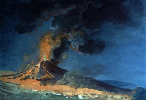
Is this the most famous volcano in the world? The shape is instantly recognisable: the twin peaks give the appearance of an unintended gap where something has been removed. Naples of course has the reputation that anything that is not securely fixed down can quickly and involuntarily change owner, so perhaps a missing bit of mountain is not such a strange idea. And whole towns have gone missing here. Pompeii and Herculaneum had been completely destroyed, and although the stories of the fatal eruption were immortal, in the writings of Pliny the Younger, the towns themselves had been forgotten. Pompeii was rediscovered in the 1500’s during the building of a canal. The find was documented but not pursued. Herculaneum was re-discovered in 1709. In December 1738, an inscription was found which labeled the excavated ruin as Theatrum Herculanensi. Only now was it realized that this was ancient, lost Herculaneum. The excavation of Pompeii began in 1748, at first rather destructively but later better organised and with great effort. Still, the site is enormous and much remains hidden under the layers of ash. The excavated part is very impressive. The numerous public buildings and original graffiti provide a less-than-flattering view of the morals of Roman life (‘bawdy’ would be a generous way to describe the culture) but bear witness to a practical attitude to town design. The access roads were especially well designed. The ancient bakeries along them provided drive-through food for the people on the carriages. Naples is the original home of the pizza (it is hard to find anything else to eat in its restaurants), and looking at Pompeii it is easy to see how this would have fitted in with the people on the carriages grabbing food from the passing displays using the pizza base as their plate.
In between the mountain and the sea, and amidst very fertile ground, this was a good place to live. Of course now we know better. The mountain is now recognised for the volcano it is, and the area to the west is known to be an active caldera. We wouldn’t build a town there. Except of course, this is where Naples did grow up, the only European city with an historical eruption within the city limits. Everything you see is volcanic, every single hill or depression a memory to some ancient eruption.

One of dozens of skeletons found in the boathouses of Herculaneum, of people killed but the eruption while waiting for rescue.
The local people are now well aware of their environment. The Vesuvius Observatory is the oldest volcanology observatory in the world, founded in 1841. At the moment the main area of concern is at the opposite side of Naples, at Campi Flegrei, where increased ground heat is present with some inflation. But Vesuvius is not forgotten. At the moment it is completely quiet, its fires spend in the 1944 eruption. This interlude will not last. One day the mountain will rumble into life again. The lava will flow, and it will not find a free channel to the sea. Anywhere it could go, suburbs have sprung up.
To see what the future holds, look at the past. Those who forget their past are condemned to repeat it. Our view of the past Vesuvius is shaped by this single destructive eruption of AD 79. What is a normal eruption like? How long is typical between eruption? History should tell.
Origin
Vesuvius began to grow around 17,000 years ago. There is evidence for 8 large eruptions, similar to the one in 79 AD or even larger. The main product from Vesuvius is andesite, known for causing explosive eruptions. Lava flows tend to be comparatively small in volume. The main impact comes from large explosive eruptions and associated pyroclastic flows. The cause of the volcanic is -obviously- underground, a combination of the subducting African plate situated to the east, underneath the Adriatic Sea (it is a pretty mixed-up region, with bits of Africa found in various places around Southern Europe), and extension.
Vesuvius is a grand cone, appropriately called Gran Cono, 1280 meters high. At the top is a round, deep crater where a few weak fumaroles can be seen but otherwise there is little evidence of activity. To the north and east, there is an arc-like rim surrounding Gran Cono, lower than the peak. It is called Somma, and is 1130 metes high. In the valley between the rim and the central cone are some old-looking lava flows. The rim is the remnant of an earlier phase of the mountain, 17,000 years ago when when a larger caldera formed. Not much of that remains. The combination of the rim and cone is called Somma-Vesuvius.
Since Roman times, there were significant plinian eruptions in 472 and 1631, although smaller than the 79 AD event, as well as an unknown number of smaller eruptions. The 1631 eruption signalled a change: after this, Vesuvius had frequent small eruptions, until 1944. Than it changed again, to its current silence. But how well do we know the history before 1631?

Lava flow, from a map made in 1833 by John Richardson (source: https://www.rc.umd.edu/gallery/map-vesuvius)
History
By 79 AD, Vesuvius was not considered an active volcano. It had been silent for long enough that it was seen as extinct, insofar that concept existed. There had been earthquakes in the decades before the eruption, and interestingly, the Pompei aquaduct has ceased to work. This may have been caused by local uplift around Vesuvius, causing the water supply to try to run uphill.

A list of historically documented events for the period 79-1631. Source: Claudia Principe and collaborators, Chronology of Vesuvius activity from A.D. 79 to 1631 based on archeomagnetism of lavas and historical sources, Bull Volcanol (2004) 66:703–724 . Click on image for full resolution.
After 79, people (at least the survivors) knew better. There were further eruptions, but quite irregular. The records of these older eruptions are fragmentary. Magnus Aurelius Cassiodorus and Procopius the Cæsarean allude to eruptions in 472 and around 512. The first one was major, with ash falls as far as Tripoli and perhaps Constantinople. The 512 eruption (the date is in question: 532 has also been suggested) was mildly explosive, for which a DRE of the fallout has been estimated at 0.025 km3. Procopius mentions lava flows which occurred during both eruptions, albeit his report is from hearsay as Vesuvius did not erupt during his own four-month visit to the area.
Paulus Diaconus (720-c. 787) mentions Vesuvian eruptions in two documents, and is also the first to suggest that the original Somma crater was related to the 79 AD eruption. He mentions the ash eruption of 685. After this, there is a period of 300 years where we have very few written records. There is a mention of events around 968 and 999. In January, 1037, lava flows reached the sea.
A large eruption in 1139 is stated in one account to have lasted eight, in another, forty days, but little is known about it. It has been argued that many of the lava flows on the side of the mountain, coming from parasitic vents, date from around this time. After this, there is little written evidence until the next big eruption of 1631. It is assumed that the mountain was mostly dormant over that 500 year period.
The 1631 eruption was a significant, plinian affair which caused many casualties. It came as a surprise: the mountain had been dormant since living memory. But living memory is not that long. A description from 1570 mentions highly active fumaroles in the crater with glowing rocks and occasional explosions, something that seems to have been forgotten about 60 years later.
After 1631, a very active period followed, with always something going on. Around 1770, Sir William Hamilton wrote that the mountain had for many years ‘never been free from smoke, nor ever many months without throwing up red-hot scoriae usually followed by a current of liquid lava’. Jospeh Wright made some 30 paintings of the mountain, invariably shown in eruption, even though there were no documented eruptions during his visits, around 1774. Eruptions were long lasting: the 1944 eruption was the culmination of an episode that began in 1913, with a peak in activity in 1929.
The 472 and 1631 eruption are classified as VEI4. The 79 AD eruption was VEI 5. The Avellino eruption, 4000 years ago, was significantly larger than the 79 eruption, and was a VEI 6.
472
This was during the collapse of the Roman empire. The area had seen widespread destruction caused by the invading tribes, and population was already in sharp decline. Into this stressed life, a major eruption happened. The prevailing westerly winds send the fall-out to the east, away from the sea, the opposite to what happened in 79 AD. The regions affected by the pyroclastics and ash falls remained de-populated for centuries. The coastal areas escaped the impacts, and stayed inhabited. From the locations of the deposits, the eruption column is estimated at 20 km height. It was big, but was not on the scale of 79.
1631
The 1631 eruption is famous. It began in the early morning of 16th December, with incessant earthquakes and ash fall. Mid-morning on the next day, a large eruption column formed. As the ejecta came down, the mountain seemed to disintegrate and material flowed down like water. It reached the coast and caused a tsunami several meters high. Before the eruption, the mountain had been densely vegetated, perhaps even inside of the crater. The mountain remained active for several years, although without the intensity of the first few days. After it, the mountain was desolate and some 3000 people had been killed. There were four more eruptions that century, a much higher level of activity than before.
The 1631 eruption changed our language. The word lava is Neapolitan by origin. It came from the Latin labe (to flow), and was used for volcanoes rather than rivers for the first time in 1633. How much lava was actually involved in the eruption is disputed. The written records mention seven ‘rivers of fire’ of which most were rivers of hot ash. Dating of some lava flows show that three flows on the southwestern slopes date from the 1631 eruption.
The eruption was probably similar in size to the one from 472. The eruption column was 15 km or higher.

The build-up to the 1631 eruption, from Emanuela Guidoboni, Vesuvius: A historical approach to the 1631 eruption “cold data” from the analysis of three contemporary treatises. Journal of Volcanology and Geothermal Research 178 (2008) 347–358. Click on table for full resolution
1944
The phase of frequent effusive and strombolian eruptions lasted for 314 years, with a slowly decreasing peak energy of the eruptions. It appears that over time, the magma slowly cooled and a plug build up making eruptions more difficult. The last one of the series was in 1944 and is well documented. It took place in the midst of the battles of the second world war and it caused significant damage to the allied bombers. The earthquakes started in early March. The diary of Leander Powers states:
Saturday, March 17, 1944. While we were just finishing supper, someone called to say there were huge red streams of lava flowing down the sides of Mount Vesuvius. It was a sight to behold. Never had we seen such at night, usually a faint red glow at the most. As we watched the streams, like giant fingers flowing down the sides, we could see a glow in the sky. All during the night and Sunday there were quakes of the earth with tremendous roars -similar to thunder- from Vesuvius. The windows rattled, and the entire building vibrated. (http://www.warwingsart.com/12thAirForce/Vesuvius.html)
It is interesting that it mentions the red glows seen before the eruption, showing lava was already present. The diary goes on to describe the lava flows entering Naples and the cinder cones and lava rocks. Finally:
Friday, March 30, 1944. The eruption seems to have abated very slowly during the past few days. Cinders and ashes have been raining down over all the villages in this section, but seem to be slowing up. The smoke from the crater is apparently changing from the intense black to white again. Yesterday, I looked at the Autostrade through my glasses, and it is apparently covered with cinders as is the entire mountainside. Only two weeks ago, I rode up the Autostrade and then walked several hundred yards up toward the crater. Yesterday afternoon, we rode in the ambulance, and, on the way back, we took a shortcut via Pompeii. Bulldozers were plowing the cinders to the side of the road in huge banks. Practically all the gardens and vineyards are covered to a tremendous depth in the area all the way from Vesuvius to Salerno. Many people are homeless and without food, but they seem to take it in stride, just as the Northerners take the snow in winter. After this eruption it’s easy to visualize the destruction of Pompeii – a most amazing and uncanny phenomenon. From my quarters I can still see what appears to be small areas with smoking lava, but the smoke from the crater has abated. Today, the wind is blowing inland, and it appears that cone is much lower than before. Vesuvius is definitely not dead after all these years of inactivity.
This is the only description I have found mentioning physical changes in the appearance of the volcano! The effusive event started on March 18. Lava fountaining happened on 21 March. Explosive activity happened on 22 March with ash falls at 500 km from Vesuvius. After April 7, there was no further activity. The cooling magma plug has now blocked the conduit. Nothing more has happened up to the present day.
Twin peaks
The most notable feature of Vesuvius is its twin peaks. Because the second peak is actually a partial ring, it is seen on different sides of the main cone depending where you are looking from, although it always looks double. But this aspect is not mentioned in the oldest descriptions.

Vesuvius about the Year 1500. From the earliest known engraving of the mountain and surroundings, printed 1514. Labels: 19, Palma; 23, Sarnus fl.; 24, Pompeii; 29, Turre Nunciatae; 31, Herculaneum; 32, Marilianum’; 33, Pomilianum; 35, Palæpolis; 38, Sebethus fl.; 39, Neapolis. Source: https://en.wikisource.org/wiki/Popular_Science_Monthly/Volume_69/December_1906/Vesuvius_During_the_Early_Middle_Ages

(Antonio Navarro, 2004 http://www.earth-prints.org/bitstream/2122/1468/1/04%20nazzaro.pdf)

The modern view
There is a written description from Strabo, less than a century before the 79 AD eruption. It states: “Above this locality Mount Vesuvius stretches. It is entirely occupied by beautiful fields, except for the top. The top itself is almost entirely flat but is quite barren, the land having a cinerous appearance; there are cracked cavities, opening on rocks sooty as if consumed by fire. We could suppose that this field previously burnt, and later its fire craters died out as the material burnt completely.”
This does not sound much like the current mountain: where is the mountain and where is the deep crater? It has been taken as evidence that instead of two peaks, there was only one mountain. It makes sense that the 79 AD explosion must have removed a fair amount of mountain, and therefore the appearance may have been quite different. But exactly what it looked like, and how tall it was, remains unknown. The description may indicate that the younger cone wasn’t there, but was a plateau at the level what is now the saddle between the twin peaks. Or the description may relate only to the central cone, and indicate it was taller than Somma and had no central crater.

The view during the Roman period, from a fresco. But is this all of Vesuvius?
There is one Pompeii fresco which shows only a single mountain, before the 79 AD eruption. This together with the absence of any mention of a second peak during this time, may suggest the younger peak did not exist. But the case is not clear, as the fresco does not show the full mountain. The drawing from 1500 looks very much like the current view. By 1631, the current mountain view was largely there, including the central crater which deepened by 450 meter during the eruption. However, the pictures show the old rim (Somma) to be considerably higher than the central cone, while nowadays the cone is higher. Could the younger cone have begun to grow during the early middle ages? It is not impossible – volcanic cones can grow surprisingly quick.
The next eruption
After eruptions in 1906, 1929, and 1944, Vesuvius has gone eerily quiet. The size of the eruptions had slowly been diminishing since 1631. The likely interpretation is that in 1631, an open conduit was created which since has slowly been blocking up as the magma cooled. Since 1944, it has remained blocked. What does this imply for the future?
Vesuvius seems a fairly unpredictable volcano. It has gone through phases of frequent lava flows, and times of infrequent explosions. We may now be at one of those times where it changes from one to the other. The effusive eruptions may not have completely ended: there is still a chance of another 1944-like eruption, with lava flows endangering the upper suburbs of Naples. But if the conduit is really blocked, the next eruption will be explosive. It will come from the summit: historically, this is where explosions happen. There will be warnings, with earthquakes, lively fumaroles and probably inflation within the crater and perhaps without, lasting for months. A large tectonic earthquake could increase the chance of an eruption a few years later, judging from the 79 AD event. Perhaps this can weaken the blocking plug, and create new channels for magma to rise, albeit at a leisurely rate.
To see how a new eruption might announce itself, the events of 1631 provide a clue. 60 years earlier, highly active fumaroles and glowing rocks were seen, indicating that a failed eruption took place. A few years later these signs had disappeared again. Explosions and landslides in the crater started several months before the eruption. Loud underground explosions were heard two months before, and at this time wild animals disappeared from the summit area. A few weeks before the eruption the vegetation was drying out, indicating degassing. Two weeks before the eruption seismic activity became strong enough to be felt by residents. Finally, the bottom of the crater began to uplift and a few days before the eruption, it had reached the rim. If this happens, it is time to swing the emergency plans into action.
How long would we need to wait for such an eruption? Based on its history, it could be a long time. The time of eruptions every 20 years is over. The dormancy before 79 AD may have been centuries. Before 1631, it was as long as 500 years, although there may have been smaller eruptions in the intervening period. We don’t have a long enough sequence to look for repeating patterns, and we don’t know what is normal and what isn’t. The current length of silence is not unusual, and could easily last for a century or (much) more.
The crater of Vesuvius is deadly quiet, apart from the buzz of the tourists walking around the rim. The fumaroles are hardly visible and nothing seems to threaten an eruption. This tourist heaven could last a long time, or Vesuvius could suddenly decide to rumble back into life. The only thing that can be predicted is its unpredictability. Vedi Napoli e poi muori! What a place to build a city.
Albert


There’s a live seismo from Agung now https://magma.vsi.esdm.go.id/live/seismogram/
Excellent. Thanks! To someone who needs “Seismograms for Dummies”, that looks like ongoing, numerous sharp fractures followed in some cases by the passage of gasses? Must be the “brittle fractures” they mentioned?
POPPERS!
The first time I ever saw those were on Redoubt’s drum plots.
Basically, they are sort of miniature tornillos. Actual tornillos have a longer coda, about 10 seconds or so.
Drum plot seems to have changed over the past hour or so, – since about 11:30 CIT. The chart looks much busier – double the number of those small “poppers” than 12 hours ago.
Agreed. Been watching it with … well, honestly, anticipation.
Hopefully no one drops any Mentos into that bottle of soda.
the popper at 17.06 local time today looks to have a fairly long run with clipping at the start – more of a tornillo I guess – but it seems to have gone back to the normal (still having small poppers) state after that – does that duration of tornillo give any measurable implication on the amount of magma in motion ? and can that quake be picked on multiple seismos to give more info ?
Great article, thanks Albert! I can heartily recommend Mary Beard’s Pompeii book on the history and daily life of the town. It does not concentrate on its destruction, but uses the event to show how we learnt about daily life. Also mentions Herculaneum and its one-way traffic flow!
Crustal extension in the Campanian volcanic arc, is that caused by back-arc spreading which often occurs in subduction zones?
Is the magmatic plumbing system of Vesuvius connected to the large magma chamber of the Campi Flegrei volcano?
It is caused by a bit of rotation at the southern half of Italy. That has formed a band of stretching along which the volcanoes are found. Vesuvius has its own magma chamber, although at a much deeper level it will tapping the same magma source.
Thank you for the update, Albert. I was there last week, but did not climb Vesuvius. My sister, who climbed it last November, told me that the cinders around the fumaroles near the top, were hot underfoot. Pompeii struck me as an ideal place to live, were it not for Vesuvius looming large above it. The shops and cafés on the narrow streets, the sheltered central gardens, the tiling and frescoing of the houses: it felt like a real community, preserved from the time it disappeared under the ash. There us film footage of the 1944 eruption, showing hot gases bursting through floor tiles, and houses and churches falling under the path of the wall of lava, as people evacuated with what they could load onto a cart as they headed away from their towns and villages, away from the steady encroachment of hot cinders. A novel I read told of the dangers of being trapped between 2 rivers of lava, with no way out, as they met downhill from villages and homesteads. The evacuation plan was published the day I arrived, but it appears to funnel everyone to the same railway stations and ports. At Pozzuoli they told me how the ruins in the town, which are beside the promenade and port, sometimes fill with freshwater, not seawater. And Solfatara remained closed. They said that this is because they do not know what changes are happening below the surface. It should have been solid ground where the family fell through the crust, into boiling mud, below the dry top layer, and the gases which caused the boy to pass out first were near to the public walkway there was talk that a sinkhole may have been caused by the heavy rain which the area had recently experienced, but that this hollow area below ground, would need to be mapped and understood before there would be a decision to reopen it. It surprised me that Campi Flegi is just a town, with a fine station building, and football stadium, and that the locals did not consider that they lived in or particularly near a volcano. I stayed on Ischia, and the port there is completely circular, and sheltered from the sea. The local magazine for tourists was very cross that the recent earthquake had been made public, and that it was deterring visitors. It is a wonderful place to visit, and there is much culture and art to see and explore. The station announcements advise you that pickpockets operate here…. Anywhere else and CCTV would get them arrested. It was easy to observe them working in pairs, and so one must keep all valuables out of reach and securely stowed. I overheard a few people sharing their experiences of being robbed and the difficulty of reporting a theft when your phone has gone as well as your bank cards. This has been a local tradition for millennia too, so life goes on. The city is a vibrant mix of old roman fountains, and wide squares where boys play football in large groups, and sophisticated high culture with expensive shops, while migrant street sellers offer cheap counterfeit goods along the adjoining thoroughfares. I thoroughly recommend it, and like so many others, would love to go again as there is so much more to see.
Thanks Alyson! I loved the city. It is such a vibrant place. But the railway station is in a less pleasant area and it seemed the American hotel chains were all concentrated there. We stayed in a nice hotel a bit higher up, half an hour walk into town (or better, a taxi). And yes, you do leave things you can’t afford to lose at the hotel.. but we had no trouble whatsoever.
All I managed was to get my foot ran over.
I also found that a good Zippo can command a high price.
Think I know the novel you mentioned ‘The Angry Mountain’ (think that was the title) by Hammond Innes Speaking of Vesuvius-related fiction, can I give a shout-out for Robert Harris’ ‘Pompeii’? Interetingly, the pre-eruption uplift fracturing the aqueduct was a key plot driver; Harris had clearly done his homework
Thanks Michael – yes that was the one. And Robert Harris’s book is excellent. I read another book called Fire Mountain, or something, about Soufriere, but set on Ischia. Not the one that actually details the Soufriere eruption, but a different book. Fiction is a great way to get into how it might actually be to live through something like that. I had last visited Naples in the late 1970s, on the interrail trip with my sister. The main station was very different then. Brown biting flies were a feature, not found anywhere else. Shoeshine boys wanted to polish our flipflops, as they jostled outside the station with their wooden boxes with a step for resting your foot on. The ham sandwich in the station cafe had a large patch of blue mould in the middle on the ham… Groups of 12 year old boys spat at us for refusing to give them our cigarettes on the underground, and we accepted a lift from Castellamare di Stabia with some kindly lads in a fiat bambini up to the top of the peninsular above Sorrento, where we were dropped off to walk on to a hostel with straw mattresses that was a 4 kilometer hike up steps through vineyards, but offered spectacular views down to the Isle of Capri – and further south there were notices warning that cholera was rife, and not to drink the water…. Italy is a country of extremes – great warmth and friendliness, mafia organised crime, and for the most part a relaxed approach to life and rules
For some reason Akismet puts your comments into the dungeon, waiting for the daily comment rescue mission. It should not do this with regular commenters. It may perhaps happen if the same email address is registered to two different accounts. We will try to get a knowledgeable admin to look into this. – signed: A lesser knowledgeable admin
I’ve found nothing obvious. I’ve told Akismet to stop being so belligerent in future…
It looks like quite a busy stack developing off the N coast of Iceland.
http://en.vedur.is/earthquakes-and-volcanism/earthquakes/
If I remember correctly, that’s near the edge of one of the slabs of a graben out there.
Yeah, there is a graben out there, it’s part of the Nafir-Skjálfandadjúp volcanic system
Source: http://www.sciencedirect.com/science/article/pii/S0025322715001267
Thanks for the article.
By the way, don’t forget the painting of Vesuvius in the house of the Centenary (Pompeii) .

Every time I see that Image I think “Where is Spartacus?”
It does suggest steep cliffs where rope ladders would need to be used to gain access to the hideout.
This is the painting I had in mind of Vesuvius as a single cone, prior to AD79, thanks
Interesting enough I just read Willhelm Jenson’s Gradiva. A quick read. My copy has a translation of Freud’s analysis of the novella.
It is a cute story of an archeologist, who falls in love with the image of a Roman/Pompeian girl. He visits the ruins and she appears to him in person. Their is a neat twist. They have much more in common than he suspects. Gradiva does present a nice romantic view from the early 19th century. Especially in the descriptions, which echo the idealized paintings of that era.
I also took some time last week to read Neville Shute’s _Round the bend._ I found out about some recent biographies of Shute/Norway and learned he had spent time in Bali. Part of _Round the bend_ is set in Bali. It is an interesting look at how the ideas of a prophet are spread throughout the world via aircraft mechanics and engineers who can travel about with little notice.
It is interesting how volcanos are equated with romance and paradise.
Last I heard they were trying to authenticate the identity.
The Skull of Pliny the Elder May Have Been Found
That’s pushing it a bit… But it does serve to illustrate the answer to the long running question about being in lava. You are still much less dense than it is. Evan as dense as we are, humans are pretty close to 1030 kg/m³. Basalt → 3100 kg/m³.
I found some info about the shot. I thought it was photoshopped, but he claims it’s genuine. In the link below, there is also a bonus picture of what the shoes looked like afterwards.
https://petapixel.com/2013/07/13/photographer-gets-so-close-to-lava-that-his-shoes-and-tripod-catch-on-fire/
Note to self: read entire thing before posting link… Further down he admits that the shoes and tripod didn’t burst into flames due to the lava, but he used an accelerant in order to get a cool Facebook profile picture. At least flames are not photoshopped.
Still doesn’t forgive the frivolity with the lava.
Agreed. That’s Darwin award quality.
Charles Babbage, claimed to have burned the soles off his shoes when climbing Vesuvius. That would have been sometime in the 1840s or so.
Are Gunung Agung and Manaro able to erupt with a force of minimal VEI 6 for each of the two?
Through geologic time, calderas are pretty common in Indonesian systems. So I have to say the potential is there, but it depends on the state of the system and how much magma is feeding into it.
I’ve updated the links on the Agung post to include the drumplot and two webcams. It’s certainly popping away this morning (afternoon).
It took Vesuvius in 1631 weeks to months to get from something akin to this point to the eruption. Volcano watching may require patience.
Thanks Albert.
Really appreciate your hard work. VC is such a great find for a newbie like me.
Great timing, I’m going there next week!
Tiny, picky note: Vesuvio’s last eruption was in 1944 (not 194) 😉
The spam deamon didn’t like this and put the comment on hold in the dungeons of despair! It has been told off (severely so) – admin
Thanks Boris, this is now fixed (and I am fixing other typos as I find them: the post was a bit of a rush job). You know more about Vesuvius than any of us: what would you add to the post?
I looked in on the web cam at the Mountain Observation Post just now, and there was a TV crew with a spokeswoman presumably doing a piece on the volcano. Shame it was covered in thick cloud.
A brief trawl through google news revealed this entry.
I may be reading people’s comments here incorrectly, but it seems that we are… “at variance” with this piece?
Any views on that ?
http://www.antaranews.com/en/news/112888/volcanic-activities-of-mt-agung-slowing-down
It may mean nothing. Activity goes up and down even in the run-up to an eruption. Perhaps the crack helped to reduce stress, but that could change again. However, it is also true that an eruption is never guaranteed. It could still misfire, and having to wait for the next seismic crisis in another decade before going off. Volcanoes don’t do schedules.
I fully appreciate that it could be exactly as you say… hours..months..years… or nothing at all.
I was referring to the odd comments I’ve seen.. I think that includes one from yourself(?) that the drumplots were looking very busy still, possibly even intensifying.
But I don’t know how to read a drumplot, beyond seeing that there is activity of some sort.
It did intensify between 11.30 – 14.30 local time.
https://magma.vsi.esdm.go.id/live/seismogram/
Think that’s the difference.
The article may be looking at past days tallies, and people here are mentioning events of shorter duration, live as they happen.
Yes, that would make sense.
Thanks.
Didn’t St Helens quakes die down in the weeks leading up to her 5.1M & lateral VEI 5 eruption? So much so that Dixie (the Governor) let residents back in the day before?
One of the challenges with volcano monitoring, especially in situations like this is that there will be natural waxing and waning. Regardless of whether an eruption occurs, there are many many other examples of volcanoes erupting where the pre-eruptive earthquakes weakened, then strengthened, then weakened, then strengthened all the way up until the time of the eruption.
Pinatubo and St. Helens both did this in more famous examples, but it also occurs in volcanoes that have failed to erupt (such as Cerro Negro).
That article was published in the Bali Tribune earlier. Actually about or following the time that there was a drop off in activity on the chart from magma – that someone has posted below.
There’s also another problem from what I can tell – the population in the official declared red zone is supposed to be about 70,000 – but they ended up with about 135,000 evacuees. The article may have been released in order to ease apparent overreaction to the assessed risk.
https://www.youtube.com/watch?v=9YIsrjk0SjY
Pretty sure it’s just insects, but it almost looks like there is ash blowing around in this webcam view at night.
Okay, my only thought right now is it must be an intense rain storm that is whipping rain around? Definitely not just insects, but I don’t see the signs of an eruption on the seismogram.
Big drops dripping off of some type of overhang? Their speed would be slower and look anomalous relative to the surrounding rain and easily blown askew by the wind. Plus, the big drops would be highly reflective. Just a thought.
It could be, but it was looking like that 2 nights ago…. May be ash, dust, smoke, fog…. Or any number of things. I watched until I was going cross-eyed a couple of nights ago (whilst doing something else… I do have SOME sort of a life !). Having done so I get the impression that it could send you crazy after a while. Wait til morning… or verification, whichever comes sooner.
My eyes tell me it’s ash falling and whipping around, but my head looking at the seismograms, the lack of notifications, and the simple thought that my eyes have been wrong many times before says it’s something else (possibly just dust and dirt whipping up on a windy day too?)
Yeh, I’m thinking it’s most likely a bit of dust on a windy night.
It looks like a blizzard and snowfall at times out there, which is why I’m remaining somewhat doubtful about it just being dust, but who knows.
I’ve seen plenty of snowstorms, and I know the manner in which snowfall can whip around, which is what it looks like on this camera right now. The only thing I can think of that would resemble that is ashfall, but like I said, I’m probably being mislead by my eyes in some manner.
I’m curious if the more intense earthquake period that occurred a few hours back was a brief emission or throat clearing, and we have possibly seen some mobilization of that ash as it blows around the area? I suppose we probably won’t find out more until the morning there.
It is exactly as I saw it a couple of nights ago. I was quite happy to believe that it was a mixture of rain and insects until it became much finer… like smoke… and a couple of times it appeared to be moving vertically upward…. Which rain doesn’t do very often. I waited until first light…. No eruption. So I assumed it was either fog or a swirl of dust.
I reckon I might have twigged it. I was watching that a night or so back, when it was not raining and it dawned on me it might be someone smoking near the camera, maybe on a balcony nearby? Clouds of smoke, ash whirling around… likely?
Yes – in fact looking at the outpost building on Google there’s a large balcony right under where I think the camera may be. Tonight there’s a cable or cobweb draped across it…! Smokers…my guess.
Here’s a link to a snapshot of the place. I’m assuming the web cam is under the roof line above the smoker’s balcony. https://ibb.co/mJFyFb . Photo acquired via Google Maps (sorry, Google).
Drat, that was meant to follow on from my 15:46 comment. Sorry.
So then… Smoke and ash… but from a somewhat more…localised source?
Yeh.. That’s tidy…and credible. I can go with that.
Volcano Discovery mentioned the following: “PVMBG estimates that 150 million cubic meters of magma have accumulated in the recent recharging episode”. This is the equivalent of .15 cubic kilometers of magma.
First off, there is a little bit of ambiguity here, but I’m going to assume that when referencing the “recent recharging episode”, they’re talking about the recent intrusive events that started no longer than a month back.
That may not sound like a ton, but that’s a LOT of magma in a short period of time. For reference, by volume, that much magma is the equivalent of a VEI-4 eruption (.15 cubic kilometers of magma). We also know that Agung had been inflating prior to the current events (insar mapping showed inflation in the late 2000’s). Still, this does not give any great indication of what an eruption would potentially do, but it’s definitely notable that the size of this intrusion is in fact very large, and it may not be done. I’m assuming that they were able to estimate the intrusion size by looking at GPS changes and using a model of magma chamber depth (not public data unfortunately).
That is quite a lot, in a short period of time.
This is “just” the volume of a conventional VEI4 Hekla eruption, or of 2010 Eyjafjallajokull eruption,.
With a bit more, it can make a blast comparable with Grimsvotn 2011 eruption (at 0.8 km3).
So, this eruption can very likely reach a VEI5 volume, considering the 50 year repose time.
Still no let up in the activity.
That accumulation rate is impressive. If that is just the recent influx, I’d like to see a rough estimate for the preceding years based on GPS readings.
I think that the recharging episode has been going on for at least a decade. That is how long inflation has been happening. The amount of magma given makes sense over that period, but is far too large for a few months.
Is hot molten basaltic magma coming from below stirring up Agung’s magma chamber which could be filled with evolved magma? When a magma chamber filled with evolved magma is stirred up by injections of hot basaltic magma, it gets (over)pressurized, causing an eruption.
There hasn’t been enough time since the last eruption to generate evolved magma.
There will still likely be plenty of evolved magma in the upper chamber. Remember that most eruptions only empty out a fraction of magma chambers.
Remember, this is not Iceland, so the magma will be different. In arc-based volcanic systems, a lot of the volatiles and “evolved” magma comes from assimilating mantle as the melt travels upwards from depth as opposed to the slower process of fractionation which is seen in Iceland or any magma chamber that sits for too long. Most of the assimilation happens before the magma ever settles into an upper crustal magma chamber. In fairness, we would possibly see slightly less evolved magma (basaltic andesite as opposed to more pure andesite), but for Indonesia, Basaltic Andesite can very well cause large eruptions.
Why is basaltic andesite able to cause large eruptions (VEI4+)?
The main method I’m aware of is due to the higher viscosity of andesite and the ability (or lack of) of the system to de-gas. If andesite is sat in the shallow chamber and a fresh influx of basaltic magma comes up from the deeper chamber/mantle then the andesite acts as a ‘bung’. The fresh basalt will be gas-rich so this ‘bung’ acts to increase the pressure in the shallow chamber until it reaches a breaking point.
Dawmast, why would it not be able to cause large eruptions is the better question?
Well, this is basically the process from which any volcano would erupt. So yes, this is occurring.
With that said, I would caution that “evolved” magma is a relative term. For Agung, evolved magma probably means more of a pure andesite magma as opposed to the more fresh basaltic andesite. This is what happened in the 1963 eruption.
I should have been more specific with my response. I interpreted ‘evolved’ from dawmast as meaning towards the rhyolitic end of the spectrum in terms of composition. Maybe I’m just wary of people thinking that rhyolite is the only prerequisite to an explosive eruption.
I agree that for Agung, andesite is the ‘evolved’ magma type and that assimilation of mantle or crustal sedimentary deposits are the cause of this increased silic content rather than fractionation.
Sorry Gaz, I meant this response as a response specifically to Dawmast haha. Hard to specify which person you are responding to here.
The paper on the 1963 eruption says that basalt intrusion into andesite reservoir is the main cause of eruptions at Agung, hence the basaltic-andesite eruptions.
https://www.youtube.com/watch?v=VHd0apRykLo
New camera?
Is that heat we can see on side of the Volcano looks like something is flickering?
Nice find thanks. Looking west to the volcano from close to the east coast. Middle of three mobile comms towers (so we can see the first off to the right there – begs the question why not put the camera on that one!).
Is it just me, or is blowing around stuff occurring on this camera as well?
And there’s some flickering too, but I guess that could be a light on top of the comms tower
Hypnotic, watching insects flying across, like tiny meteors.
Thanks, It’s a different view.
I’ve noticed with this cam the clouds do move away from the top of Agung, so you do occasionally see it.
Thanks, I’ve added it to the Agung links post for future reference.
The M2.5 underneath the Mauna Loa crater gave the tilt meter a jolt. It was quite shallow
Daylight again…No scenes of devastation.
Yeah well you aren’t looking at all the pots to wash in my kitchen this morning. Last nights dinner was less like cooking and more of a ceramoplastic flow.
Heh… same issue here. Wife wanted me to stir fry but now the mess is hers to deal with. She knew what she was getting into when she asked so I don’t feel guilty about it. I have 400 km to drive today.
Is that steam coming out of the crater the wind seems to be blowing eastwards but the cloud ? movement above the crater is still .
It definitely looks like steam to me, and there’s more of it, venting somewhat higher than previously… I think.
So just asking some questions to myself here..
So one interesting aspect of the Bali volcanoes is that the big eruptions have erupted a range of magma that includes a full spectrum of magma, unsurprisingly including Rhyolite. This is not a big surprise if you know anything about big eruptions, since they very often involved rhyolitic magma erupting. With that said, the standard eruptions here are Basaltic-Andesite and straight Andesitic, and any magma more evoled than andesite in Indonesia is fairly rare.
The rhyolitic magma is likely more difficult to activate, so I’m personally curious as to what would cause the activation of the more evolved magma in the rare but large eruptions (such as the VEI-7 blasts at Batur). Does all the evolved magma live in the deeper chamber? If so, how would it work its way up towards the shallow chamber? Conversely, if there is a portion of the shallow magma chamber that possibly hosts crystallized evolved magma, what does it take to activate this? Would it just need a significantly larger-than-normal injection of basalt? Or does it possibly need an enormous depressurization via caldera collapse or simply a large eruption to activate?
I find it hard to believe that rhyolite works its way up from the deeper chamber. I have better time imagining this scenario:
An expanding shallow chamber (I like the analogy of ‘breathing’) with every injection of fresh basalt>Increased space for fractionation away from the main conduit and adjacent chamber matrix>rhyolite remains around the edges of this large chamber>a large intrusion and eruption occurs>the rhyolite is activated during this intrusion, but possible doesn’t erupt at this point>the eruption destabilises and empties the chamber causing a caldera collapse>the rhyolite is erupted.
Meanwhile in Iceland, Öræfajökull sneaked in a star on the map…
Tuesday
03.10.2017 13:52:41 63.987 -16.559 2.0 km 3.2 99.0 6.8 km ESE of Hvannadalshnjúkur
IMO:
“Öræfi. Earthquakes of this magnitude are uncommon in the area, but the last earthquake larger than M3.0 was in 2005.”
Looks like some magma movement in fits/spurts prior to the main shock? Can’t say whether or not what appears to be tremor is normal for this station, as I’ve haven’t been paying that close of attention.
Oraefajokull is awakening as the hotspot activity increases under Vatnajokull.
I think there is a decent change that Oraefajokull could erupt within the next 10-20 years, if activity keeps building up.
I am sure at least we will see some of this build-up of activity.
An eruption there is totally possible. And it would be a mix of initial VEI4-5 explosive phase followed by some explosive activity or lava flows. Eruption should be overall rather short lived, if we look at the two past eruptions, that are known.
This volcano is not so well studied. We don´t know about its eruptions prior to settlement of Iceland. It must have had many.
Interesting indeed!!!
Here is a film I took from the location in Aug 2011:
Excellent! Some interesting shapes along the edifices/flanks.
Do you know if the summit is a central dome or the remains (plug) after erosion?
I’m not sure of its composition and I’m yet to find a paper on the specific petrology of the feature, but this paper nicely shows it between the current caldera and a proposed older caldera to the NW.
http://citeseerx.ist.psu.edu/viewdoc/download?doi=10.1.1.725.9819&rep=rep1&type=pdf
I’m grateful that the new Agung Webcam has been found. It is a shame though that with such an important edifice, that it is not of the quality of the Sakurajima webcam “http://www.qsr.mlit.go.jp/osumi/bousai/top.html?gmn=funCM_S3”. That picture is one heck of a good lowlight ALL NIGHT. Smoking now.
I don’t know if it’s appropriate to post this (if not please remove), but since it’s about a volcano I take my chances. I made a (music) video about my stay at Unzen, Japan, in July 2015.
You can see the jingoku (the hells), the beautiful landscape and of course the mountain and it’s new dome and spine, still smoking a bit.
It’s probably a bit different than a regular video though.
https://youtu.be/TJ-7aG4lGQc
Beautiful! Thank You for the video.
Looks like Herdubreid is at it again a little too. Still, Iceland has been very quiet since the Katla flood!
New camera is shaking quite a bit atm, does that happen more often cuz of the wind or is it something else?
Always suspect wind, but it really depends on how well it’s mounted and it’s exposure to wind. If it’s seismic, the drum recorder should be going nuts.
…well, there were,a couple of saturation events in the lat few minutes. You can tell from the seismic trace clipping.
With this cam, emptout posted, the clouds do move occasionally so you can see the top of Agung.
https://www.youtube.com/watch?v=VHd0apRykLo
I also have been noticing smoke in different places. I also had noticed that on another cam. Are people setting fires there for a reason?
Something seasonal, perhaps ?
I’ve noticed this also.
That’s how they dispose of garbage in Indonesia. Fires are burning in backyards everywhere.
Thanks I was just curious. 🙂
Smoke just below camera now .
I like this “all in one” broadcast: https://www.youtube.com/watch?v=FirVBS1Z_QI
Thanks, now added to the list.
On that cam, which currently has a clear view of the summit, there seems to be a great deal more steam around the summit than I’ve seen to date.
Note that the one with the currently clear view is of Sinabung, not Agung…
Thank you, Tomas. I should have noticed that. You are correct of course.
Clever little spider on cam2. Thinks she has plans for those bugs attracted by infrared light..
Couple of updated maps
https://vatna.carto.com/builder/255e2130-c71e-4a05-9249-8ce19bf14255/embed
https://vatna.carto.com/builder/403810ba-867b-479e-bb8a-232b2cafcb4b/embed
Thank you for these! Interesting! I see Hvannadalshuknur had a good rattle to the south-east, at quite a shallow depth. A little unusual.
Very interesting! Thanks!!
A thick cloudy dawn in Bali. Looks wet, too. (Amazing how many dawns on Bali I have now witnessed!) I was looking at the seismogram, and do I now detect small tournillos in the mix of activity? Small being the operative word, but I think their presence has increased. Also, some ‘softer’ fractures that look more fluid / steam, possibly minor magma-movement like. Feel free to throw chucks of andesite at me if you think otherwise.
I’ve noticed this as well, although I can’t see past versions of the graph so don’t have a good baseline to compare it against.
You can’t get rid of me now. Spotted this c/o the UK Independent Newspaper, from Nature on a study on the Siberian Traps, the volcanic activity and the mass extinction. Interesting article: https://www.nature.com/articles/s41598-017-12759-9
I think the association of the PT extinction and the Siberian traps is pretty well known (it has to be – I wrote about it..), but more data is never a bad thing. They also mention the interaction of the eruption with the coal fields which is plausible but with more uncertainty.
Big green star for Bardarbunga.
Thou art released! – Admin
Adjustments of the famous caldera plugg?
Followed by a 2.2
Thursday
05.10.2017 09:50:09 64.611 -17.510 2.6 km 2.2 99.0 3.3 km SSE of Bárðarbunga
Thursday
05.10.2017 09:46:39 64.621 -17.454 4.1 km 3.7 99.0 4.1 km ESE of Bárðarbunga
After dropping a little bit for a day or two, the quakes have risen back to where they were.
New summary on Agung from magma indonesia: https://magma.vsi.esdm.go.id/press/view.php?id=101
An eruption is still considered most likely.
Just to clarify – when looking at the Agung seismograph, are these features that I’ve highlighted in red the small tournillos referred to?
If so, then I agree, from what I recall seeing then they weren’t there – or at least there weren’t many – a few days ago.
The ones you highlight I recall someone (Carl?) saying these show gas / steam or fluid movement, cracking rock as it flows through? They might be noisy tournillos? We need an expert! The ones I was looking at were smaller.
I was thinking that was them, (spelling I think should be “tornillo” (no :u”) – called that because the plot looks a little like a screw – edge on. They seem to start with a little softer shake (as the head of the screw) than I guess the “poppers” from small rock fractures, then decay with pulses at about 10 second intervals – the plot shaped a little like the threaded shank of the screw. There’s probably a lot more of them in that section of graph, but not very clear against background noise.
So… assuming that’s correct, then from what I could find out, they may or may not indicate pending eruption, may or may not indicate something about the nature of an eruption – if it happens. That doesn’t give me high hopes that they’re useful for forecasting what might happen.
My googling doesn’t shed a lot of light on this – just arouses my curiosity as whatever process causes it is interesting.
Yes – we need an expert.
You’re right. Why am I using tournillo? Perhaps it’s my Englishness, adding “u” in when not necessary, It would be really good if a tornillo expert could come and expound on these for us. Regardless of spelling, I think they are significant and I don’t recall seeing them in earlier seismograms. I do remember Carl or one of the others saying they represent fluid movement – possibly magma. I get the feeling we’re beginning to see magma on the move here.
To geolurking – yes – I put the highlight in red – just so what I was talking about would show up clearly.. Our local GNS uses red on the live charts when the signal clips. Magma indonesia don;t seem to do anything when the signal clips – no red on the chart.
I guess they’re significant too – as I agree that they have increased in number and probably amplitude. “Something” is happening, apparently – but what? Is it perhaps pulses of degassing liquid magma squeezing through something semi-sold – resisting the flow, then it bloops through and stops for 10 seconds until pressure builds up again?
Are those your red highlights? I ask because I think the actual plot uses that color to denote teleseisms and it confused me.
Galeras is the volcano where these things were first noticed and discussed by them that do this for a living.
http://www.sciencedirect.com/science/article/pii/S0377027396000923
Sorry I can’t add much more, I’m freaking out about Nate. It appears to be nowhere near the threat of Camille, but it’s following a similar track and life cycle… and is going to be riding a warm water eddy as it crosses the Gulf… like Camille did. Nervous? yeah, Terrified? No, not yet. The models are in my favor.
Thinking of you, just don’t send Nate my way, now people are getting sick, I don’t know if it is the flu, mold or what is going on, October usually feels pretty safe, except for the ragweed 😀
Well… the thing to consider, is that New Orleans still hasn’t gotten around to getting all their pumps working properly. Nate could turn out to be quite un-nerving for them.
… one bad part/good part about Nate is that’s it’s gonna be hauling arse. Bad in that it makes the eastern eyewall rougher to deal with, good since it won’t hang out for long. Precipitation from a tropical storm is directly related to its speed. Harvey was the other end of the scale. Speed according to tonight’s news is 18+mph forward motion. That also hinders strengthening. Camille was quick, but i think much slower than Nate will be. Camille was able to complete a few eyewall replacement cycles and had a long implemented flow pattern (actually started as a Cape Verde tropical wave). Nate is just now getting started.
I think Iceland doesn’t like it when Bali gets all the attention.
http://en.vedur.is/earthquakes-and-volcanism/earthquakes/#view=map
you’re absolutely right: another star for Bardy
(IMO)
Friday
06.10.2017 02:42:25 64.686 -17.452 4.4 km 3.4 99.0 6.2 km NE of Bárðarbunga
Still the alternation between quakes in the SE and in the NE. Clearly both sides are taking part in the reflation (if that is what it is) but the quakes only resolve stress on one side – so hte other side has to catch up. The same happened during the eruption.
Certainly looks like a reaction to the activity on the ring fault from the other day, nice clean tectonic quakes on the drumplot.
A few interesting ones at Öræfajökull, slightly deeper than recently and moving from depth to the surface. Small magnitude currently and looks tectonic from the drumplot.
I have been trying to find published results about the post eruptive earthquake sequence. So far the only thing I have found is an abstract for a conference presentation by Kristín Jónsdóttir et al. I can’t find the actual presentation or any other published material, but they do say in the abstract that the polarity of the moment tensors switched sign quite soon after the eruption ended and that this suggests that fault movements reversed.
“Preliminary results suggest that caldera fault movements where reversed soon after the eruption ended in spring 2015 when we also observe outwards movement of GPS stations around the caldera, indicating re-inflation long before any seismicity increase was detected.”
http://meetingorganizer.copernicus.org/EGU2017/EGU2017-12535-3.pdf
Usually major eruptions like Pinatubo, Krakatoa, Mt St Helens, start only after a period of several weeks (2 or even 3 months) of seismic unrest.
A long wait. As very thick magma slowly makes its way to the surface.
Therefore I would expect the Agung eruption to occur more by November.
We only had 2 weeks of unrest.
Business has been slow in my shop of late, so I’ve been watching documentaries on well known eruptions on youtube.
Although it is a different volcano, and I would imagine it has very different habits, the one which struck me as being relevant here (at least in terms of social and psychological aspects ) was that of Pinatubo.
I can well understand the intense pressure placed on the scientific team responsible for advising the government regarding a potential major eruption. It must be difficult enough having to carry out life-threatening duties, without having to worry about people hounding you on questions that no responsible scientist could answer.
This seems to have been a feature with Mount St Helens as well.
Looked in on the Mountain Obs Post webcam to see they’ve split the feed. Not sure I go for this. Before I hunt to see if they have the original feed still available, does anyone have an update on cams, please?
As regards our conversation on tornillos, I think what we are seeing are not tornillos.
The webcams I’ve been sent are on the Agung post from last week, although I may have missed one or two from the comments.
I’m getting the impression the cams are scaling back. The Mountain Obs Post was the most consistent (with the smoker’s balcony below!) but that’s the one that is now hosting the feed for other cameras and splitting the picture.
some interesting lines from the abstract here http://cat.inist.fr/?aModele=afficheN&cpsidt=2808582
The occurrence of tornillos is the most important criterion for determining the probability of an eruption at Galeras in the current period of reactivation. The maximum daily number of tornillos and the longest duration of individual events occur near the end of each episode. Within an individual episode, the durations of single events increase progressively near to the point of eruption. A positive correlation is observed between the total number of pre-eruptive tornillo signals during an episode and the volume of material ejected by the eruption.
Hi,
I’m curious.
IMO/tremor graph: why are blue lines (2-4Hz) above green lines (1-2Hz) only for these stations:Snaebyli(snb), Lodnygijahaus(lod), Fedgar (fed)? thks
Possibly a greater wind exposure.
Avcan are reporting that they could possible be a magma intrusion under Tenerife.
https://youtu.be/aenI8FvVn5Q
”possibly be”
New-old post is up:
http://www.volcanocafe.org/a-super-pooping-supervolcano