What makes a volcano dangerous? Clearly, the severity of any eruption plays a role. So does the presence of people nearby. But it is not always the best known volcanoes that are the most dangerous. Tseax is hardly world-renowned, but it caused a major volcanic disaster in Canada. And sometimes a volcano can be dangerous without actually erupting. Lake Nyos in Cameroon is a well known -and feared- example.
Over time, we have become much better at managing volcano hazards. Accidents can still happen, but timely evacuations have helped tremendously, and sometimes even mitigation is possible. Among European volcanoes Vesuvius and Etna are known to be particularly dangerous, but there have been few casualties since the 17th century. But one event is invariably overlooked in these statistics. Few people have heard about it, even though it happened as recent as this century, and in spite of this being the largest volcanic disaster in Europe since 1669, and the second-largest world-wide since Pinatubo. And we still do not fully understand what happened, how it happened, and what role the volcano played.
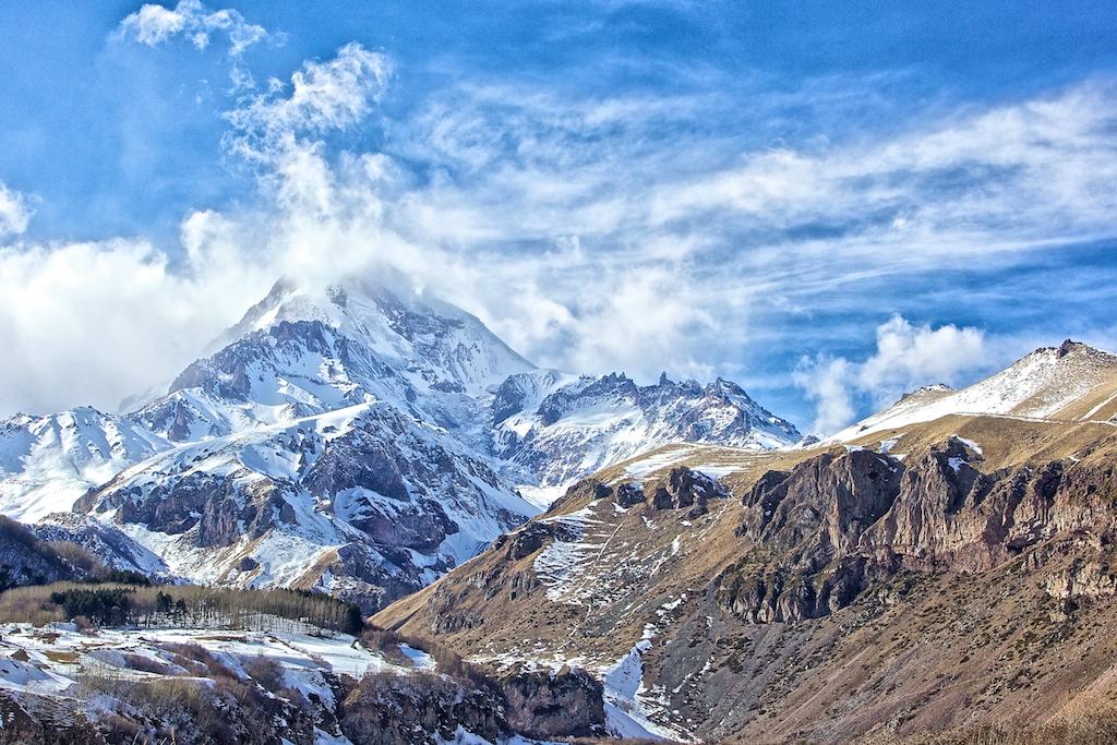
Mount Kazbek
It is an impressive mountain in an impressive region. The peak lies at the centre of the Caucasus range, at the border between Russia and Georgia. At 5047 m (16,560 ft), it is the second tallest volcano in Europe. According to a Georgian legend, a cave high on the mountain contains various relics, including Abraham’s tent and the manger of baby Jesus. The shape of the stratovolcano is rugged, reflecting a long history of erosion, a volcano past its prime. Ancient lava flows have spread some 15 kilometer, mainly to the south and filling in the ancient river valleys. Like Elbrus, it is an extended volcanic centre which has been in the same location for half a million years. And like Elbrus, this is not just a relic: there is still life left in it.

Dating of the various flows and volcanic centres show four phases of activity, separated by long times of dormancy. The oldest phase was 400-430 thousand years ago: the lavas from that time are mafic. The Caucasus upthrow fault appears to have provided a magma conduit from the mantle at that time. The next phase was not until 200-250 thousand years ago; now it produced lavas that were andesitic. The faintly visible caldera, 5 kilometers across and surrounding the current peak, dates from this time. The third phase occurred 90-120 thousand years ago, with andesite and dacite lavas. The magma was evolving over time, and the direct conduit to the mantle was closing. At this time the mountain reached its largest size. The current phase started 50 thousand years ago and appears to be still continuing. Distant ash covering Neanderthal sites in Russia has been chemically identified as coming from Kazbek, indicating a large eruption happened here 40,000 years ago, perhaps at the start of this phase.

Geological map of the Kazbek neovolcanic center, Greater Caucasus, composed by V.A. Lebedev. (1) Glaciers and firn fields; (2) Quaternary alluvial sediments and stony talus; (3–7) volcanic rocks of the Kazbek center: (3) phase IV (less than 50 ka); (4) end of phase III (90–120 ka); (5) beginning of phase III (90–120 ka); (6) phase II (200–250 ka); (7) phase I (395–435 ka); (8) Late Quaternary andesite dikes and necks of the Devdoraki copper deposit; (9) Pliocene granodiorite and quartz diorite of the Dzhimara pluton; (10) sedimentary and volcanic rocks of the Early and Middle Jurassic; (11) Jurassic gabbroic rocks of the Fiag don complex; (12) Late Paleozoic metamorphic and volcanic rocks; (13) Carboniferous granitic rocks of the Dar’yal and Gveleti plutons; (14) ledge of the caldera of the Paleo Kazbek volcano; (15) Quaternary volcanic apparatuses (Figure and caption from Lebedev et al 2014: see Sources at the end of the post).
The central peak seems to be inactive: it hasn’t erupted for perhaps 100,000 years. Instead, the eruptions are coming from satellite peaks, which form an arc to the south of the summit. The Lesser Tkarsheti peak erupted some 6000 years ago and this is most recent confirmed eruption. One lava flow is dated 750 BC but this is unconfirmed. Widespread hot springs show that the heat is still there, underground. These are mostly situated on the flanks, around 3 kilometers altitude.
The summit region is covered by glaciers, but the mountain is rather steep to hold on to its snow and ice. Glacier collapses are not unusual. The Kazbek area has 12 main glaciers. Of these, three are known to cause collapse flows, the Devdorak, Abano and Kolka glaciers.
The first recorded example is from the 18th century. To the south of Kazbek runs the Georgia military road, later used for the Russian conquest of the region. It runs along the Terek river, and has suffered several times from blockages caused by ice flows coming down the mountain. On June 19, 1776, a thunderstorm occurred after a period of hot weather, and during the storm a large ice-debris flow came down, which blocked the Terek River for three days. A temporary lake formed, flooding several villages and drowning both villagers and their cattle. When the Terek River broke the ice dam, it flooded the valley downstream, destroying bridges, dwellings and crops.
Similar episodes occurred during the 19th century, but mainly as mudflows: the ice-debris flows did not recur. The reason appears to be the retreat of the glacier. It no longer reaches the site where the glacial collapses occurred.

Devdorak glacier terminus: the origin area of the “Kazbek blockages” of the 18th-19th centuries. Note the sheared edge of the glacier, and the rock face to the right and above it. Left: in 1899 (Mushketov 1905); right: in 2005 (photo by O.V. Tutubalina).
Glaciers are known to surge, when the ice flow suddenly speeds up, and the glacier covers distances in days that otherwise would have taken months. The surges can bring the ice forward by hundreds of meters or more. The speed at which a glacier advances is set by the pressure from behind, caused by the weight of the snow and ice, and by the friction between the ice and the ground. If melt water lubricates the bottom of the ice, or worse, so much water collects that it physically lifts the ice, the pressure from behind is suddenly pressing against an open door. Surges are unstoppable, and can move ice walls tens of meter high. But they are slow enough that people can safely evacuate. But if the ice were to break up, and mix with the water, and especially if this happened on a steep slope, the results could be more dangerous. Perhaps this is what happened on that day in 1776. Certainly the thunderstorm and the previous hot weather suggests that water, both rain and melt, played a role.
Kolka glacier

Kazbek seen from the International Space Station. Kolka is the dark glacier just below the centre, running from right to left.
The Kolka glacier lies in between Kazbek itself and Mount Dzhimarai-Khokh, the second highest peak in the Kazbek formation, 4780 meters tall and 10 kilometers to the west of Kazbek. The blackened glacier starts at a little outside the old caldera, in a cirque: a semicircular basin with near vertical edges. Cirques are a common feature at the head of a glacier: they form by erosion of the rock sides, forming deep basins with vertiginous sides.

An example of a deglaciated cirque, a mini-Kolka: Loch Brandy in Scotland
The cirque at the head of Kolka is located at an altitude of about 3500 meters. Far above the cirque are the glaciers coming down from the peak of Dzhimarai-Khokh: they forming overhangs which seem in perpetual danger of collapsing unto Kolka. From the cirque, the Kolka glacier follows a short valley before it joins the Maili glacier, in a larger valley which descends towards the north. This becomes the Genaldon river. There is a small village down the valley, Karmadon. Shortly after the village, the river enters a narrow canyon with the appropriate name of Gates of Karmadon.

The Kolka glacier has history: there is something inherently unstable about it. In 1969, the glacier began to surge. It pushed forward meters to tens of meters each day. Initially, it had been 3 kilometers long. By the time the surge ended, in 1970, it had grown to 7.5 kilometers. During the surge, it did not detach from its source: the surge was fed by thinning of the ice up-stream.
But Kolka can also do much worse. In 1835, the original town of Genal, sharing its name with the river, in the valley above Karmadon, was destroyed. It is not known what happened, but in hindsight we can make a guess. In 1902, a double disaster occurred. On July 3rd, an ice/rock slide came down the valley which reached a distance of 11 kilometer. It started when four hanging glaciers fell on the glacier below. Apparently, the entire distance only took four minutes! This indicates a speed of flow of 180 km/hr: this was no mere surge. Three days later, an even larger slide came, caused by two further glacial falls. 36 people died, both at Karmadon, and at Werkhni Karmadon where a thermal bath house had been constructed. The flow had reached 100 meter depth, with blocks thrown up 140 meters into the air.
The 2002 disaster
The first indication of the looming trouble was on Sept 10. Mountain climbers found that there had been mudflows along the upper river valley, with trail and the river banks washed out. At the top of the glacier, they saw evidence for rock and ice falls: the steep wall of Dzhimarai-Khokh was unstable over a kilometre of length. Three lakes had formed along the upper river valley. All this indicated that there was a considerable amount of water building up. It should be noted that the climbers had not been there for two years, and the mudflows and rock falls could have happened at any time in that period.
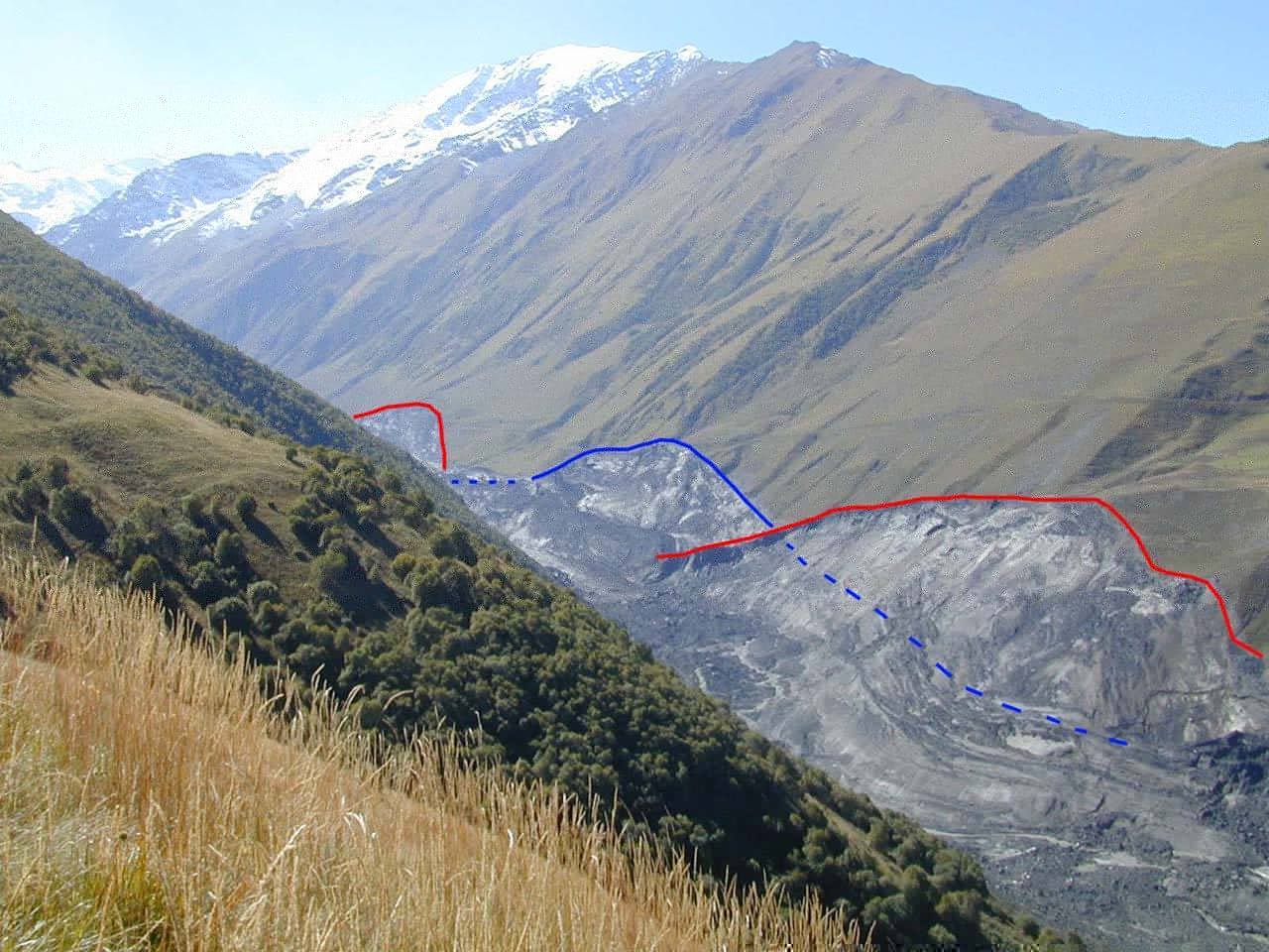
The disaster struck on Friday night, Sept 20, at about 8 pm. Images taken a few weeks later showed that a section of the steep wall of the cirque had come down. The scar had a volume of four million cubic meters, a mix of rock and ice. In the years before the fall, these rocks had been covered by hanging glaciers. They were no longer there. The material had fallen on to the Kolka glacier from a height of 900 meters above it. The Kolka glacier has a gradient of 5-10% over a length of 3 kilometer. The force of the impact and rebound detached the glacier from the rock wall and from the ground. A volume of 80 million cubic meter of ice began to slide downhill, containing up to 75% of the total volume of the glacier with a thickness of 50 meters.

Upper avalanche path of the Kolka-Karmadon rock/ice slide. The summit of Dzhimarai-Khokh and the detachment zone are in the background; Kazbek volcano is to the left (outside the image). Red arrows point to active talus-derived rock glacier in the lower right corner, steam or dust cloud at the foot of the slope where Kolka glacier has been sheared off and overridden the tongue of Maili glacier. Flow directions of two different and subsequent flow phases are indicated with yellow arrows. Photo: I. Galushkin, 25 September 2002. Figure and caption from Haeberli et al. 2004.
From the subsequent events, we can infer that the glacier had been held in place by static friction. The impact briefly detached the glacier from the ground and when it re-established contact, within seconds, it was a broken mass, beginning to move sideways. Moving material is governed by dynamic friction which is less than static friction. Because the glacier was already lubricated by extensive melt water, the friction was now insufficient to stop the movement. The glacial mass began to accelerate down the steep slope. This is already unique. Rock falls of this volume and height on glacier are rare but not unique: such falls have occurred elsewhere. But those falls didn’t make their glaciers detach and move. And if this was already unique, what happened next was extraordinary.
The broken ice mass splashed over the moraine opposite the wall, but most was redirected by the moraine down the glacial valley. The wave moved from left to right, leaving marks high on the surrounding rocks, before reaching the Maili glacier. The flow kept accelerating as a wave. The wave front came to resemble a flash flood of mud, ice and rock; it was followed by a second wave with even more debris.

Impact zone where Kolka glacier was eroded. Numbers refer to important parts of the triggering mechanism (cf. text): 1. main impact from wall; 2. ice debris thrown across left lateral moraine; 3. first (minor) splash of mud at lower end of left lateral moraine; 4. start of swing- like flow of the main mass due to deflection at left- then right-lateral moraine of Kolka glacier; 5. second (large) splash of mud forming fast mud/debris flow outside the right lateral moraine of Kolka glacier and across the tongue of Maili glacier; 6. slightly slower flow of main mass along inside of right lateral moraine; 7. temporarily blocked distal parts of fast mud/debris flow (5), crossing gap between right lateral moraine of Kolka glacier and left lateral moraine of Maili glacier and flowing across traces of main mass after its passage. Photo: I. Galushkin, 25 September 2002. Figure and caption from Heaberi et al.
The flow now had to make a 90 degree turn. At this place, it left a mud mount 250 meters above the glacier. Seeing how fast the flow would have had to go to reach that kind of height in the turn gives a minimum speed of 250 km/hr, and possibly up to 300 km/hr.
How could the flow reach such enormous speeds, and maintain them, on slopes no steeper than that found in a road tunnel? Over the glacier, it can have been the effect that makes ice skaters reach high speeds on a solid surface: high pressure on ice can create a thin, almost frictionless layer of pressure melt. In the valley, it must have been the sheer mass of the mud which carried the flow. A quick calculation shows that a speed of 300 km/hr can be reached in free-fall when falling 700 meters. The detachment occured at 3500 meters, and the joining with the Maili glacier is at 2700 meters. That means there is only just enough vertical fall to reach those speeds, assuming the flow was frictionless. The original impact on the glacier may have contributed but it had a volume of only 10% of the total, so it cannot have contributed very much. Perhaps only a fraction of the flow reached the fastest velocities needed for the height of the mud mounds. Air resistance could have been overcome by the sheer mass of the flow, or the U-shape of the valley caused the air to be pushed ahead, forming a blast wave.
From here on, the Genaldon valley is almost straight but the flow kept moving from side to side, still reaching 200 meters above the valley. The flow now slowly decelerated: when it reached Karmadon, the speed was down to 100 km/hr. But it remained dense: nowhere were trees thrown up by the flow, as happens in snow avalanches. Imagine what this would be like. The first thing to hit you is the gale-force air blast wave, almost immediately followed by a category 4 hurricane, where the wind is made of mud and water and the rain is a horizontal waterfall consisting of rocks and ice.

The seismographic record shows that from the collapse of the glacier to the destruction of Karmadon 18 kilometers down-stream, the event took only 5.5 minutes, which makes out the average speed over this distance as 200 km/hr. This includes the initial acceleration and the deceleration in the Genaldon valley! The numbers are absolutely frightening. And it maintained these speeds even though the gradients aren’t that high. This was not a steep mountain slope: it was river valley where people could live.
At the entrance of the gorge, the flow became severely restricted. The ice dropped out and formed a black barrier. The residual went on as a mud and fine-grained debris flow. It continued for another 15 kilometers. There had been flooding earlier that summer, from rain storms, and the debris from that became entrained in the flow. The flow was now down to 10 meter thickness and the speed was a leisurely 40 km/hr. Finally, it petered out, perhaps 35 kilometers from its origin. Over the next days, a shallow lake formed behind the ice dam which flooded much of the area.
There is little in the way of eyewitness reports. One couple mentions a ‘white cloud had come through the dark’. Another person heard a noise like heavy construction machinery. But otherwise, it seems to have come out of the night without warning (although it was almost full moon), and for such an enormous event, it was remarkably silent. The noise was absorbed by the flow itself. It took time for the news of the devastation to come out. The destruction of the power lines would not have helped. Authorities in Moscow were informed only on Saturday morning.The search-and-rescue started shortly after but there was little left to be rescued.

This image was captured NASA’s Terra satellite on April 9, 2004. The Genaldon River Valley (center) appears to have been lined in slate where the avalanche left an 18-kilometer trail of ice, rock, and pulverized stone along the slopes.
The big danger in snowy mountains comes from avalanches, which can reach speeds almost as high. But this was no avalanche; the density was ten times higher than that of snow and the slope much less than that needed for avalanches. The closest analogue is a pyroclastic flow, when a frictionless mass of fragmented rock, hot ash and possibly water is blown out at high speed. Of course, another name is needed when the mix includes cold ice rather than hot ash: let’s call this a cryoclastic flow. It is just as deadly as its hot counterpart.
The Kazbek event killed around 70 people around Karmadon, and a further 50 died in the mud flood below the canyon. One of the casualties was a actor of national fame, Sergey Bodrov Jr., who had been filming in the canyon. All but four of his film crew also died. Only about 20 bodies were ever recovered from the disaster. The actual death toll may have been higher than what is reported: there are reports of refugees having settled in the upper valley, unregistered. But even a total of 125 would be the second largest number of fatalities from a volcano since Pinatubo, and it could be the largest number for an European volcano since the 17th century.
Or no collapse?
An alternative view of the disaster is that the initial collapse did not occur, at least not on the Friday night. This was argued by Stephen Evans et al. (see Sources, below), who used a satellite image taken 8 hours before the collapse to show that the rock had already gone by that time. They point out that the seismograph had shown no clear signal of an initial impact, and argue that the rock wall had fallen down over months, and that the slide started because of the increasing weight pushing on the water underneath the glacier which pushed the front over the constraining toe of the ice. Apart from the onset, their reconstruction of the event is similar to that presented here. They find a larger volume of moving ice (130 million cubic meters) and a much thicker initial glacier (over 100 meters in depth) but similar velocities. The initial acceleration is found to be 0.8 m/s2. For the slope of the glacier, that corresponds to almost frictionless acceleration. They fit a friction coefficient of 0.05, which is only a little higher to that obtained in the olympic sport of curling, and a factor of ten above that of ice skates.
Their points are well made but not fully conclusive. The continuing rock falls reported several days later suggests that the wall had been severely destabilised, consistent with a larger fall. The impact could have been muted by the water under the glacier. The splashing sideways over the moraine is more consistent with a more energetic start. it is also difficult to see how water can lift ice over a toe while maintaining a very high pressure: one would expect to water to spurt out, leaving the glacier grounded. But neither is their model excluded. The truth may be in the middle: much of the rock had already collapsed, but the final push came from a further rock fall. However, their assessment of a ‘standing start’ (no forward push from the impact) agrees with my own conclusion, I was happy to see.
Glacial heat

What makes the Kolka glacier so unstable? Notably, it is one of three glaciers on Kazbek to show slides and collapses, although not all do. But no other glacier in the Caucasus, other than on Kazbek, shows this behaviour. What is unique about Kazbek? Did volcanic activity play a role? This is disputed, but the fact that these cryoclastic flows are only seen in a volcanically active region ,and start at an altitude where hot springs occur, is suggestive.
The name of the village contains a clue. Karmadon means ‘warm water’. There are a variety of hot springs in the region. When the Kolka glacier began to retreat in the late 1800’s, one such spring surfaced from underneath the tip of the glacier. The opportunistic locals quickly build a bath house and huts around the sulphurous site. This was the bath house that was destroyed in 1902. In 2002, the first team to land (by helicopter) in the source region after the event had to leave in a hurry, overcome by the overpowering sulphurous smells. There clearly was strong geothermal activity in the region. The smoke seen in satellite images has also been interpreted as due to this, although this may also have been due to continuing rock falls.
However, heat underneath the Kolka glacier cannot have caused the collapse of the rock wall and overhanging glacier 900 meters above it. The geothermal regions are mainly around 3-3.5 kilometer, while the summit of Dzhimarai-Khokh is considerably higher than this and is itself not known to be volcanic. So the situation is more complex than this. A plausible suggestion is that the collapse was a natural, inevitable event, caused purely by the build up of the overhang, perhaps aided by the warming during the 20th century weakening the rock. But the completely unexpected effect on the Kolka glacier was made so disastrous because of melt underneath it. The whole glacier was already being lubricated, and the purchase to withstand the impact from above just wasn’t there. Sloping ice and ground heat are an unstable combination in any case. The unstable overhang became a sword of Damocles hanging over a powder keg. The collapse came just at the wrong time, when the glacier was already primed to go into surge mode.
If a glacier grows in cold conditions, where the bottom is ice, the friction can carry a considerable amount of weight. If now the bottom begins to melt, the weight carrying capacity is less, and the glacier may suddenly become unstable. This has been seen in ice falls in the Alps, although such glacier collapses there happen on much steeper slopes (some 35 degrees) than seen on Kolka (10 degrees).
Could it happen again? The satellite images show that the newly-grown overhanging glaciers have some deep crevasses. The danger that they will fall is certainly still there. The rock wall is a kilometre long and a collapse could happen at any location along it. The Kolka glacier was almost entirely lost in the event. The cirque has been refilling with snow and ice and we don’t know whether the glacier is beginning to reform. This region of the Caucasus is perhaps not particularly safe for scientists to visit and that could be hindering the assessments of the situation. It is an uncomfortable situation, with a clear danger but too little knowledge of the current state of affairs.

Left: NASA image from 2002, post-disaster, Right: a recent image on google maps. The orientation and scale is approximately (but not exactly) the same. (The current map also includes Kazbek which is just outside of the old image.) Zooming into the head of the glacier, the cirque walls can be clearly seen. The snow overhangs are back. The visible glacier is the Maili, which is not implicated in the disaster. The Kolka glacier always was dark with dirt and rubble, and it is impossible to see how much has regrown. A collapse remains possible. Whether it would initiate a cryoclastic flow depends on what it collapses onto. That will require an on-site investigation.

Could it happen somewhere else? Perhaps: with the current warming, meltwater can make both glaciers and rocks unstable. Rock falls have become common in the Alps, especially around the level of declining permafrost, at altitudes around 3 kilometer. They have reached sizes well over 100,000 cubic meters. An event similar to the Kolka collapse is not impossible, and Kolka has shown that a moderate slope does not preclude a cryoclastic flow.
In fact, there have been events with notable similarities. In 1962, part of the ice cap of Huascaràn in Peru broke off, and fell down a kilometer. It set off an avalanche of ice, snow and rock which traveled at 100 km/hr over 15 kilometers into the valley of the Rio Sante where 4000 people died. 8 years later, it recurred and this time the flow reached a city, causing 20,000 deaths. The Kolka flow was three times faster and came as a wall of ice instead of snow. If such a cryoclastic flow would happen in a densely populated area, the magnitude of the disaster could be inconceivable. The chance may be small – but it is non-zero. And the dangers may be growing: have a look at this ice fall. We don’t yet know how to recognize precursors. If it begins with increasing stress, the best way may be with monitoring ice quakes, but seismologists tend to remove those from their data!
One thing is clear: volcanoes do not need to erupt in order to be hazardous. An unstable environment can turn any dormant volcano into a clear and present danger. And that is well worth remembering.

Ice cliffs frozen to the steep rock walls of the Kolka Cirque are nearly all that remains of the Kolka Glacier. The person standing at the bottom right of this photograph is dwarfed by the ice wall and the talus slope beneath it. (Photograph courtesy Dmitry Petrakov). Source (figure and caption): https://earthobservatory.nasa.gov/Features/Kolka/kolka.ph
Albert Zijlstra, February 2017
Sources
Collapse of the Kolka glacier, Rebecca Lindsay, 9 Sept 2004
Remains of the Kolka glacier. September 11, 2004. Robert Simmon, based on ASTER data
http://www.mn.uio.no/geo/english/research/projects/nato/results/kazbek.html
Glacier and debris flow disasters around Mt. Kazbek, Russia/Georgia. S.S. Chernomorets et al. 2007. http://www.glacier-hazard.narod.ru/pdf/Ch11_1.pdf
Major events in evolution of the Kazbek neovolcanic center, Greater Caucasus: Isotope-geochronological data. V.A. Lebedev et al. 2014, Doklady Earth Sciences 458, pp 1092–1098
The Kolka-Karmadon rock/ice slide of 20 September 2002. W.Haeberli et al. 2004, Journal of Glaciology, Vol. 50, 553
Catastrophic detachment and high-velocity long-runout flow of Kolka Glacier,
Caucasus Mountains, Russia in 2002. S. Evans et al. 2009, Geomorphology Vol. 105, pp 314–321


Besides the new activity La Palma there have been over 300 earthquakes since Monday in the Azores.
Translated.
”At least 300 earthquakes of medium magnitude were recorded in the Azores Islands on Monday morning. According to the Center for Information and Surveillance Seismovulcanic of the Azores (CIVISA), since 23:47 on Sunday there have been hundreds of seismic values between 1.9 and 3.6 on the Richter scale in the Portuguese archipelago, located in the middle of the Atlantic Ocean.
The Portuguese Institute of the Sea and the Atmosphere (IPMA) warns that there is no indication that the seismic crisis that affects the Atlantic islands diminishes, and that on the contrary more earthquakes, possibly of greater intensity, can be expected in the next hours and days .
Several hundred “microseisms” were recorded on the island of São Miguel, including a “significant” event at 06:18 in the morning, which reached intensity V of the Mercalli seismological scale, reserved for shocks that generate material damage slight, cracks and disturbances in tall objects. Material damage has been recorded, in the form of broken windows and fallen poles, in several islands of the archipelago .
For this reason, the Regional Civil Protection Service of the Azores has asked citizens to remain calm and take measures to protect themselves; The population is asked to avoid the use of matches and lighters due to the high risk of gas leaks, as it is also requested that those who notice significant cracks in their buildings abandon them and inform local firefighters as soon as possible. Likewise, the Azoreans have been asked to avoid the coastal areas of the islands due to the high risk of tsunamis generated by seismic instability.”
Full article can be found :
https://amp.elmundo.es/internacional/2018/02/12/5a819d7a268e3ef8758b45f6.html
The activity on São Miguel seems to be near the Congro Volcanic Fissure System. Wiki describes it as seismically active but less volcanically active. OTH it is only a stone’s throw away from Furnas (last eruption 1630, VEI-5).
Wiki: https://en.wikipedia.org/wiki/Congro_Volcanic_Fissural_System
GVP: https://volcano.si.edu/volcano.cfm?vn=382100
Scary but interesting read. For some reason I got a gut feeling of this possible happening on Mt Rainier sometime in the future.
The spooky bit about Ranier is that a significant portion of the summit is made up of altered rock. Volcanic gas and moisture have turned to rock into clays.
And Rainier doesn’t need an eruption to have a disastrous collapse
Nope, could end up collapsing in a similar to way St. Helens, minus the eruption, maybe. Just so happens to be that the west flank is the weakest. Fortunately a very good early warning system is in place. Although extremely unlikely, I think there’s a slight possibility of this being triggered when the next M9 hits Cascadia.
Assuming Mt Rainer will collapse one day, and that’s a reasonable assumption, then it going outside an eruption would i assume be the best (least worse) possible scenario? Dealing with the results of the landslide would be easier without being hampered by an ongoing eruption.
I don’t think so. If it collapses during an eruption, it’s likely that seismic monitoring of eruption precursors will have prompted widespread evacuations and there will be few casualties.
If it goes outside an eruption, there is likely to be very little warning, and therefore no evacuations.
Yes, Scary and thinking of Rainer is a nightmare.
Curious question for the experts. There seems to have been a paucity of EQs around Bardarbunga and Grímsvötn for the last several days. is this usual or unusual? Any thoughts?
There has been a quite severe winter storm in Iceland, roads closed and everything. That often means that the smallest quakes remain undetected by the automatic system, since they are simply drowned by the noise from the storm. Or it could just be a brief moment of silence, which is, after all, not that uncommon.
Thanks for the reply, that makes sense. I’m more of a lurker (small “l”), and don’t get to check in every day, but have been following the EQ maps fairly regularly for a while now, but there always seems to be at least a couple EQs in these areas.
Great post as ever a disaster I’d never heard of our media sometimes have a very narrow focus. My first thought on reading it was to make an immediate comparison to the Yungay disaster (although that one had absolutely no volcanic connections)
Thanks, Albert, for another very informative post.
For anyone astounded by the weirdness of the debris flow addressed in this article. Don’t forget that stuff can be even more weird. Just look at heart mountain. It’s not where it was formed at. It is older than the rock that it sits on.
Instant karma. “Woof woof”
http://www.neonnettle.com/news/3164-bulldog-bites-pedophile-s-penis-off-as-he-tried-to-rape-sleeping-children
Annecdotaly, from what I understand, there was a side branch of pits terriers that were bred specifically to protect children. I wonder if this one is from that lineage.
From the articles image, it appears to be an older dog. Older dogs tend to play for keeps and are quite serious about accomplishing their task.
Numerous one liners are going thru my head now… 🙂 I’m so glad the dog was there. The girls are only 3 and 6 years old. He bit off testicles too and swallowed everything! So there’s no reattaching. Like the parents said, “he won’t be needing them now”. Justice was served.
Probably won’t happen, but insult to injury would put him into the general population when he gets to prison. Pedos don’t tend to do so well there.
So I’ve heard. 🙂
A nearby facility has a set of what appear to be little 5 x 8 foot pens. They are for the mandatory “outside” time (still inside the quad) for the ones under “close control”. When I was there, they had just moved the residents into the new building and as a group they were not happy. They could no longer see from cell to cell and couldn’t communicate via sign language. (Per my escort)
In my work, I’ve been to state prison several times. Weirds me out each time. The only thing that makes it bearable is the body alarm and large corrections officer escort.
Now, there is a philosophy that any dog tasting human blood should be put down. I don’t agree with that. Monitored for agression, yeah. But that dog did the job he was put there for. He defended the girls. In my book “good dog”. BRAVO ZULU!
This can’t be right, unless it’s a fake (penis). It should not show up on x-rays.

Edit: Indeed. https://www.snopes.com/bulldog-saves-sleeping-children/
mother easrth seems to be on the move, this came up in my news feed today,
http://www.news.com.au/technology/environment/natural-wonders/kikai-supervolcano-rising-lava-dome-reveals-magma-pressure-is-rising-beneath-japan/news-story/d0398a120cc96ddb0bcbb74ed8796960
Interesting. Note that there is a feature on the map called Showa Iwo-jima. This is not the same Iwo Jima, or Ioto, that made #1 in the NVDP series. I jumped a bit at first when I saw the name, so I had to google it.
|I suspect that if it translates from Japanese as “New Sulphur Island” there could well be a few of them….generic, like ‘fire mountain’
Iwo Jima or Io-to both can be used for sulphur island indeed.
Showa however means the period when Hirohito was emperor. In Japan they usually refer to the period of an emperor’s reign.
The island surfaced in 1934, during Hirohito’s reign.
In the north of Japan, also a new vent formed on the Usu volcano. That was during WW2 and is called Show Shinzan, with Shinzan meaning new mountaIn.
At least my trip to Japan a few years ago has left me with some vocabulary!
The new dome on Unzen is called Heisei Shinzan with Heisei referring to the current emperor’s reign (ending this year ween he abdicates)
Interesting. Rather a “Daily Mail” take on it (UK comic also known as a newspaper).
On today’s reading list is this new paper on plume dynamics:
https://www.nature.com/articles/s41467-018-02901-0
Thanks Albert for another fascinating article! Shame the area is dodgy, a lot could be learnt from some serious on-the-ground research.
Agung sends a little message that level 3 does not mean that the danger is over.
https://twitter.com/Sutopo_PN/status/963285223365472256?s=20
4th anniversary of the Kelud eruption today!
We are on the hunt for guest writers for the VolcanoCafe blog. Please get in touch if you’re interested. 🌋
Sign me up!
Pick something to write about and send it over. If you need any help I can add it to the back channel for review before publishing.
Piece on Hualalai coming up!
Fantastic, look forward to reading it 🙂
https://watchers.news/2018/02/13/devils-woodyard-mud-volcano-awakens-after-23-years-trinidad-and-tobago/
Mud volcano in Trinidad & Tobago. I didn’t know mud volcanoes could be deadly, but this one chucked debris 200 meters high in a previous eruption. I know it’s a bit of a sexist presumption, but I would lay odds that the victim was a male between the ages of 15 & 25. One video looks like the person filming is standing on the mud to film the bubbling flow front.
The swarm La Palma is continuing nine earthquakes in 90 minutes early this morning all at deeper depths.
http://www.ign.es/web/resources/volcanologia/tproximos/canarias.html
Thanks for update Janet. Following this with great interest. Use to trek in the La Palma mountains every year in november. Maybe the views have changed next time?
I wonder if there will be an eruption there in the near future. 30 km deep on an oceanic island is basically in the mantle so theres no way it can be unrelated to magma movement realistically. It seems like eruptions there are similar to mt etna with strombolian cone building eruptions but also passive lava eruptions with what look like very fast and fluid lava flows, almost like what happens on mauna loa. Its also pretty much covered in inhabited areas except its summit, which would be a dangerous situation if an eruption happens.
https://www.youtube.com/watch?v=2PMTI8Io2Ug – 1949 eruption
https://www.youtube.com/watch?v=DodH-NdUNRo – 1971 eruption
The summit is well populated:
But volcanic activity is away from the summit, in the south
The views are magic up there! Clouds pressed by winds and floating like waterfalls over mountain ranges. Also a one day trek along the ridge towards the south, passing many volcanic craters and features is recomended…
Nights there are pretty impressive too. Can be windy though.
Agree that this swarm is not alarming regarding a new eruption. But we have almost no info how the run ups to the previous eruptions. Could it have been triggered by agitation from the deep?
Yes similar sound indeed!
Latest update by IGN regarding the activity La Palma.
Translated.
”We reproduce the latest information from the National Geographic Institute (IGN):
” 14-02-2018 (17:30) SEISMIC SERIES IN LA Palma
Since the night of Saturday, 10 February, ign has located 69 earthquakes in the environment of the villages of the canaries and the town, the largest of which is 2.6 and depth 28 km. From 1 UTC on 14 February, the activity has increased significantly (53 localized events, the largest of magnitude 2.5) to depths between 25-30 km.
The results obtained from the GPS network do not see significant deformation on the island of la palma which can be linked to recent seismic activity.
More information about the seismicity located on the island of LA Palma in:
http://www.ign.es/resources/volcanologia/SIS/html/PA_SIS_eventos.html
http://www.ign.es/web/resources/volcanologia/tproximos/canarias.html”
http://www.ign.es/web/resources/volcanologia/html/CA_noticias.html ”
Video of the activity La Palma courtesy of Avcan.
Really nice visuallization! Let us hope it stays deep down!
Maybe cumbre vieja is like hekla where it erupts quickly with little advanced warning. I don’t remember what it was called, but I read a paper once about the volcanoes on la Palma and it said there is not much of a shallow magma chamber within the volcano itself, like there is in hawaii, so most of the eruption is fed from depth at the crust-mantle boundary, just above where the current quakes are. So it probably won’t take long for an eruption to actually happen when the warnings start. There is a certain similarity to hekla in more ways than one…
I don’t recall the paper, but from what I understand, activity swaps back and forth between La Palma and El Hierro on a several hundred year scale.
Now here’s an idea. Make the curlers ride their stones down the Super G course.
Im not sure why that paper says activity switches between la palma and el heirro when the only historical eruption from el heirro was in 2011-2012 and only 40 years after an eruption on la palma. Cumbre vieja was also dormant for over 200 years before 1949 and no eruptions at el heirro are known then.
im not really in a position to say a researched paper is wrong, but the claim sounds completely different to what is actually shown in the historical record. The last known eruption from el heirro that is dated happened in 550 BCE (from GVP).
I’ll take a look at the evidence when I write my series on the Canaries. The first one, an explorer style post, is almost ready.
Can you link to the paper, please?
No expert here, but that image suggests remobilisation of semi-crystallised / dried mush? It’s the right sort of depth for a magma chamber. But the seismic activity is all over the area, rather than defining a liquid centre (always the best kind of chocolate…). That makes me wonder if a fresh injection from below is re-melting the stagnant, cooling chamber? Will be interesting to see how it develops.
Thanks, I always like these. They’re the best to grasp at what is happening, 🙂
Does the paper mention Tenerife because there has been more activity around Teide over the past couple of months and Volcano Enmedio between Tenerife and Gran Canaria.
On the link below click on the right hand side 90 Dias which shows all the earthquakes over the last three months La Palma and Tenerife are completely covered in yellow balls (earthquakes).
http://www.ign.es/web/resources/volcanologia/tproximos/canarias.html#
Courtesy of Involcan video of the sounds of the earthquakes La Palma.
Nice! Apart from the sharp clicks, it sounds much like the thin ice I was skating on last week… 😊
Very similar indeed!
Impressive eq swarm in TFZ: http://en.vedur.is/earthquakes-and-volcanism/earthquakes/tjornes-small/#view=table
401 earthquakes in the last 48 hours (data from IMO, link above)
Earthquake count:
Magnitude less than 1 in all: 24
Magnitude 1 to 2 in all: 330
Magnitude 2 to 3 in all: 45
Magnitude more than 3 in all: 2
Total: 401
And no low frequency signal on tremor graph. Tectonic. Lots of stress release. But from were comes the tension?
Also a star at Kolbeinsey. Could it be a spreading event causing the stress at Grimsey and the closeby fracturefzone?
I wonder if a big glacier surge event could happen in this way from a large ice sheet. Its probably almost impossible but imagine if western antarctica suddenly surged out to sea within a year, theres apparently a high heat flow under the middle of it and quite an abundance of volcanoes showing past activity, so maybe later this century if enough undercutting happens then things could take a sudden turn into the unknown. If this actually happened the sea would probably rise meters within a decade.
On a comparatively tiny scale (although probably way bigger than the kazbek event), maybe the eventual demise of vatnajokull might include some of these cryoplastic flows. I think a repeat of the 1996 flood in 50 years or so could do a lot more damage to the glacier.
Surges do happen in Antarctica and would be expected to become more frequent. Climate in Antarctica is complex though, with the two major ice sheets responding very differently. The biggest one is quite safe – it is unlikely to show major melt in the next centuries. The smaller one may collapse. There is little doubt about the end result but a lot of uncertainty how fast it could disappear. The current fragmentation of the northernmost ice shelfs shows the process. As the shelf disappears, the glaciers feeding it speed up because they are no longer restrained. Once they no longer reach the coast (some time in the future) they would slow down again, I expect.
https://www.igsoc.org/journal/28/98/igs_journal_vol28_issue098_pg23-28.pdf
Glacial collapses in Iceland are likely, I think. Whether they will cause such cryoclastic flows is less clear as you do need particular conditions. Öræfajökull might be most at risk. The areas around the glaciers are almost unpopulated, and that is because of previous ice floods there. Iceland has a better memory than most places and knows which areas to avoid. When the Vikings first came, they could not know and settled in some unsuitable places. Those didn’t last.
The one I was thinking about that could produce a really gigantic cryoplastic flow is either skeidararjokull, where the 1996 flood happened, or the steep glacier where esjufjoll volcano is, which ends at jokulsarlon lagoon.
Skeidararjokull is steep and seems to be in a deep valley and subject to floods moving through it, so maybe if a sizeable eruption happens at or near grimsvotn in the second half of this century the whole thing might just go. And if that happens the ice sheet is probably not going to last much longer or reform to full size.
Does this graph show there are also lots of micro earthquakes happening also La Palma ?
http://www.ign.es/web/ign/portal/vlc-senales-sismicas/-/senales-sismicas/getInfoHora?fecha=2018-02-15&tipo=2&estacion=EHIG&hora=06-07
I am no expert. Only volcano interested bioscientist. However it looks like low frequency noise is dominating. Could be magma movement ?
Shows up on other SIL’s too….too far away for microquakes to show up (IMHO).
Possibly high surf in the area? Just a guess.
Pevolca has been reconvened for a meeting on Friday due to the new activity La Palma.
http://www.europapress.es/islas-canarias/noticia-convocan-comite-cientifico-pevolca-repunte-actividad-sismica-palma-20180215141019.html
Mauna Loa: the plot is thickening
Odd place for poppers.
party poppers
Thursday
15.02.2018 19:37:16 66.606 -17.810 13.1 km 4.5 99.0 11.3 km NE of Grímsey
what is the future: Submarine eruption?
Icelandic Meteorological office
Tjörnes fracture zone – large – earthquakes during the last 48 hours
EQ 846
…. and four stars …..
The swarm is magmatic. Several corrected earthquakes, of M2 or 3, have happened at 14km depth. That’s quite deep for a tectonic event.
This is a large intrusion taking place. It took 2 weeks for Bardarbunga to erupt. How long would it be at Tjornes?
For comparison, there is an VC article about TFZ swarm in 2013.
https://volcanocafe.wordpress.com/2013/04/02/how-rifting-occurs-in-iceland-explanations-regarding-the-recent-earthquake-swarm/
Jon wrote a post on his site about this.
http://www.jonfr.com/volcano/?p=7342
It looks like if an eruption happens it will be in deeper water though so no new island probably, unless it happens west of the current location near (or on…) grimsey island.
Soon 1000 eq in iceland. May be something big? 4.1 the biggest
Corrected quakes at 1.6+ (the uncorrected is a mess)
Andrej’s got some better plots that I’m sure he’ll add soon.
Impressive, well done.
If you zoom out the IMO map to north atlantic you will find more gree stars further north along the Kolbeinsey ridge. As I understand it an extension of the MAR. A strong spreading event? and this causes stress and the ongoing quakes in the Tjoernes fracture zone? The tremor graphs at Tjoernes show only tectonic ativity so far…
At least 11 stars alltogether..
In Iceland transform faults accommodate for the rifting because they just happen at another orientation in relationship to plate movement.
In Tjornes case the transform faulting is not even fully aligned with the ESE-WNW spreading but slightly offset. This allows for some magma infiltration. Nevertheless little.
Reykjanes is about 45° oriented so it’s a mix (halfway) between transform fault and rifting.
From Mezger and co-workers 2012, https://academic.oup.com/gji/article/192/2/441/576593.
The fault that is slipping now is a transform fault, not a spreading one. Any magma component will be small (but non-zero). This is the main fault, just east of Grimsey, that accommodates most of the jump in the spreading ridge between Iceland and the North Atlantic. There are occasional large earthquakes but it has been a long time. The 1910 quake was an M7 and in principle it could do something similar again. But the normal behaviour is the kind of swarms that we are seeing now (where this seems to be a double swarm).
http://www.volcanocafe.org/wp-content/uploads/2018/02/tjornes.jpeg
Today I am afraid that volcanologists can not predict the future in the medium and long term. In my opinion the frog can make the same kind of predictions. At 24h-48h, the predictions of volcanologists seem a little more reliable.
(lol, take that at a second degree please and think about the progress of meteorology over the last 30 years)
cheers
The Kolbeinsey ridge. Could that be an extension ofthe MAR (interupted by the Iceland plume) or is it a similar spreading ridge as the MAR but independet of MAR? Or is it something entirely different? In any case, this time the stars at the KR seems related to the activity at Tjoernes…
Yes: originally this was one ridge although it formed in sections. Iceland is effectively a displaced part of the ridge.
Thanks for info 😊
Quick and dirty overlay of the IMO’s weekly checked quake map with the S. Magnúsdóttir et al (2015) figure
Close-up of the feature here:
Activity is clustered within the Nafir–Skjálfandadjúp volcanic system, with last week’s clustering around the Nafir seamount and this week’s activity in the Skjálfandadjúp Basin (rift zone) and along its western margin.
Ref: https://www.sciencedirect.com/science/article/pii/S0025322715001267
Tjörnes fracture zone – small – earthquakes during the last 48 hours
Earthquake count:
Magnitude less than 1 in all: 39
Magnitude 1 to 2 in all: 929
Magnitude 2 to 3 in all: 154
Magnitude more than 3 in all: 10
Total: 1132
Tjornes has ability for M7-7.5 quakes. About the strongest possible in Iceland. Apparently it’s possible that in the plate sliding movement, some tiny degree of subduction occurs. It could explain deeper and stronger quakes.
Obrigado 🙂
you are late: 16.02.17 1pm (geneva) EQ 1222 (LOL)
IMO writes an article: http://en.vedur.is/about-imo/news/grimsey-earthquake-swarm
I have a (what might be a dumb) question. When I look at the displacement plots, are these relative or absolute motions? for example, if you look at the “east” and “up” motions, they look relatively stable until (roughly) September-October 2017, where there appears to be movement to the west (i think, negative motion?) and down (again negative motion?), then pretty much stable from November on.
I’m not really familiar with these plots. does this mean that they returned to their (roughly) original positions (this is what I’m referring to as absolute motion), or was there motion to the west and down, then it stopped (relative motion). I confused myself, but would appreciate any thoughts. 🙂
The plots normally adopt a reference frame. In the ones on the IMO link, it is stated at the top: the motions are relative to the north american plate.
Ok, thanks for the response.
Just now, a 7.5 just inland of the west coast of Mexico. Looks like Oaxaca and Acapulco may have gotten a good jolt.
M 7.5 – 2km SE of Pinotepa de Don Luis, Mexico
2018-02-16 23:39:44 UTC 16.400°N 97.900°W 43.0 km depth
Just a reminder, the location that Mexico city is built on used to be a lake. Basins are prone to shake amplification and soil liquifaction.
And Tjornes is up to 26 stars. It is still continuing.
It’s popping along like firecrackers at a Chinese New Year party. Maybe celebrating the entry of the
Year of the Dog?
Looking north overo there are still activity along Kolbeinsridge but at lower magnitude. Seems a very large connectec system has been disturbed. By what?
Still no low frequency component..

UK joining in the party.
mb 4.7
Region WALES-ENGLAND REGION, U.K.
Date time 2018-02-17 14:31:05.6 UTC
Location 51.66 N ; 3.82 W
Depth 10 km
https://www.emsc-csem.org/Earthquake/earthquake.php?id=649041
Reports of it being felt over a wide area of the UK from Cornwall to Blackpool.
This single quake will have released an amount of energy similar to the entire Tjornes swarm
For a 4.2, it was very widely felt – even noticed in London.
Seems to have been near the Wales-London-Brabant massif, near the Variscan front. Can’t find a map of the western end of the massif to confirm.
Nice to see one of my favourite fishing spots appearance a VC post: Loch Brandy.
Maybe 20 miles north of my home, Loch Brandy sits 2000 feet or so at the top of a mountain in the Angus Glen’s.
A steep climb up from the hotel in Glen Clova, where you climb the 2000 feet in around 2 miles via you at this picturesque little lochan.
It’s steep sides means that only the south side of the Loch is really feasible for fly fishing, and whilst you wouldn’t expect there to be trout 2000 feet up a mountain, apparently fish eggs are very sticky and stick to water birds at rivers and other lochs, before being transported up the mountain.
There is actually a surprising danger for this Loch, and perhaps for the hotel down in the valley: Tsunami!
http://www.volcanocafe.org/wp-content/uploads/2018/02/brandy.jpeg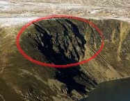
Visible in the picture that Albert posted is a dangerous crack in the surrounding cliffs. Last summer during a particularly windy, unfishable day, my fishing partner and my son decided that we’d give up fishing and walk up and around the back of the Loch. We discovered that huge chunk (perhaps 3 metres wide, and 20 or 30 meters long) of cliff face had cracked off and slipped perhaps 2 meters down, meaning its precariously hanging over the Loch.
Should this chunk of cliff decide to let go all at once, its my opinion that anyone in the south side of the Loch is in for a wild ride down the mountain riding a wave all the way back to the hotel. The size of the wave will largely depend on how deep the Loch is at the side of the collapse, but from my experience elsewhere on the Loch, it goes deep very quickly.
Anyway, I just thought I’d share my knowledge of this fine little Scottish Hill Loch.
Deadly betyg?
Should be beauty!
Thank you for all the information, about where is the hotel, I have to go back out and plant trees, (in the rain).
(i assume this is aimed at me)
The hotel is straight down the mountain from loch Brandy .
Unfortunately, I am now away from my pc, but if you search for the Glen Clova Hotel on Google earth, and zoom out a bit you can easily spot the Loch north-northeast of it
I see it, thank you, it is just such a beautiful area.
It’s absolutely stunning!
A typical U-shaped post-glacial valley, the river south esk running through it, with decent runs of salmon and sea-trout throughout the year.
Fantastic hill walking in the area too.
The weather can get wild very quickly however.
Loved your description! I just picked it as a good example of a cirque, in a completely different environment. Purely accidental that you happened to use it as you local fish pond.
Good article on the Tjornes swarm (in Icelandic): http://isor.is/frettir/hvad-er-ad-gerast-vid-grimsey
Also found this paper: https://www.researchgate.net/publication/253901252_A_new_Perspective_of_the_Tectonics_of_the_Tjornes_Fracture_Zone_Offshore_Northern_Iceland_from_EM300_Multibeam_Bathymetry_High_Resolution_MCS_and_CHIRP_Sonar_Profiles
Thanks mjf, really informative paper. Gives a different picture than what has been painted before. Interesting with the extensions to Kolbeinsridge. Zooming out the IMO map to “north atlantic view” show current extensive widespread activity from northern Iceland, northover the Tjoernes region past Grimsey and further north around the Kolbeinsridge. The activity with many green stars streacthed yesterday over almost 300 km. I am curious if there are any theories on possible mechanism behind this very far streched swarm…
No more earthquakes for La Palma have been updated since 15th February but surely the graph on the link listed below shows lots of activity ?
http://www.ign.es/web/ign/portal/vlc-senales-sismicas/-/senales-sismicas/getInfo?fecha=2018-02-18&tipo=2&estacion=EHIG&tabResult=AyerYHoy
Iceland is eqing. Can some of you here predict the next move? Like in chess.. can the movement go inland to askja barda and so?
Is this one to watch an earthquake swarm Yellowstone ?
Eight earthquakes since early this morning.
https://www.emsc.eu/Earthquake/earthquake.php?id=649276
https://earthquake.usgs.gov/earthquakes/map/?utm_source=Science%20Explorer&utm_medium=Highlighted%20Box&utm_campaign=Latest%20Earthquakes
https://twitter.com/USGSVolcanoes/status/965318586322518017
Grimsey swarm is intensifying again. 6 M3+ in two hours this evening, peaking at 3.8
A new article is up about the earthquake swarm at Skjalfandi volcano in Iceland!
http://www.volcanocafe.org/sheet-dyking-at-skjalfandi/