
There is a hidden continent on Earth. We have known about it for centuries, first as a ‘Terra Australis’, a large landmass required to balance the world (thank Aristotle for that idea), and later as a land underneath the ice, much smaller than had been assumed and leaving the world severely unbalanced with the southern hemisphere far more oceanic than the north.
After another continent was renamed to ‘Australia’ in the early 1800’s, the mythical southern land needed a new name. Or rather, an old one: before Terra Australis, in medieval times the name ‘Antipodes’ had been in common use, and this could be adapted to the modern world. All seas north of the Antarctic circle had been explored, and the land had not been found. Around 1890 the name ‘Antarctica’ was coined, and it stuck.
The mainland of the continent had been discovered around 1820 (in hindsight). The first landing was in 1853. Antarctica’s most famous volcanoes, Erebus and Terror, were discovered around 1840 and named after the two ships of the Ross expedition. After that, exploration of the new world was glacially slow, mainly because of the limited economic benefit. It was clear that this was a hostile, deeply-frozen place with little to offer. The polar plateau was reached only in 1909 (by Shackleton) and the south pole itself in 1911 (by Amundson). These are two famous names in polar history; while Amundson worked in both poles, Shackleton was a monopole: only Antarctica counted to him. But even their adventures of exploration and competition left most of it a Terra Incognito. Only in 1948 was it shown that Easst Antarctica and West Antarctica were connected and formed a single land mass.
Very little of Antartica is ice-free. There is some along the Antarctic Peninsula, some dry valleys near the Ross Sea where the wind ablates any snow or ice, a few coastal cliffs and nunataks, tops of mountains sticking out above the ice sheet, and some parts of the Transantarctic Mountains. Everything else is hidden underneath a huge glacier, which forms a large dome reaching 4 km high and stretching 1000 km across over East Antartica. The south pole which was the ultimate prize of the age of exploration lies on this dome. The ice sheet over West Antarctica is much lower.
The two ice sheets of East and West Antartica are separated by the Transantarctic Mountains, 300 km wide and stretching along a length of 3500 km. A second mountain chain runs along the Antarctic Peninsula, culminating in the Vinson Massif, the highest point in Antarctica at 4852 meters; it was first climbed in 1966. Another range runs along the coast at Queens Maud Land, called the Orvin Mountains: these are among the most scenic mountains of the continent

Orvin Mountains. Source: Wikipedia

Mount Herschel, 3335 meters high, in the Transantarctic Mountains. Source: Andrew Mandemaker; adapted from Wikipedia
The West Antarctic Rift is an ice-covered basin which runs alongside the Transantarctic Mountains from (and including) the Ross Sea to close to the Weddell Sea – it almost dissects the continent. It is one of the major continental rift systems on Earth, similar in size to the East Africa Rift. The crust has thinned to 20 km in the West Antarctica Rift because of spreading, but no oceanic rift ever developed and the rift now lies quiet under the ice. Mount Erebus lies along this rift system.

The red dashed lines delineate the West Antarctic Rift System. Source: adapted from wikimedia
Take away the ice, and a very different world appears. This has been mapped using ice-penetrating radar, done from airplane or satellite. The most recent map (2026) shows wide varieties of landscapes. There are wide plateaus, high mountains and deep ravines. Everything is deeply depressed by the weight of the ice, and much of the bedrock now lies below sea level. If the ice were gone, much of Antarctica would be covered by the ocean. But over a few thousand years the crust would slowly rise again, and eventually regain its land.

Along the coast, there are deep fjords, sometimes visible as glaciers between mountains, sometimes visible only to radar. One of those fjords is home to perhaps the most unexpected sight: a fall of red-coloured water, known colloquially as Blood Falls. It lies in-land, some 25 km from the coast at the head of one of the Dry Valleys. A glacier ends at this point, and the melt water has collected in a frozen lake. There is a seasonal waterfall that comes out of the glacier and falls unto the lake. The result is spectacular.

Blood Falls at the Taylor Glacier. Note the tent which gives a sense of scale. Source: NASA

Taylor Valley (location of Blood Falls) and Mount Erebus
The water comes from a salt water lake, deep underneath the glacier, which formed when sea level was much higher than it is now. The water is draining towards the end point of the glacier, now well in-land. It obtains its colour from a high iron content. (And no, there is currently no plan to rename Blood Falls to America Falls.) (As far as I know.)
We now know there are many lakes underneath Antarctica’s glaciers. The subglacial lakes are mainly found near the coast, and form from melt water which collects at the bottom of the glacier. Some of the lakes are stable and ancient, but others are dynamic and forming outlets. One such lake drained 5 km3 of water in 2007 and 2008, leaving a big depression in the ice. There is a watery world hiding underneath the ice.
Volcanoes
Antarctica is home to one famous volcano: Mount Erebus with its semi-perpetual lava lake. At the time of discovery in 1840, lava was flowing along its flanks. The heat has sculpted the ice on the mountain into spectacular formations.
Deception Island is another volcanic feature, a large caldera with occasional eruptions which have even damaged buildings, and 4000 years ago spread ash more than 4000 km away. Otherwise, it seems a volcanically quiet land, behaving more like Greenland than Iceland.
But there are many more volcanoes here. Along the coastline from the Weddell Sea to the Ross sea lie 7 active and 2 more potentially active volcanoes, which have had eruptions within the holocene. These are James Ross Island, Deception Island, Mount Takahe, Mount Waesche, Mount Berlin, Mount Erebus, Mount Melbourne, Mount Ritmann and the Pleiades Mountains. There are extinct volcanoes as well, notably the large shield volcano of Mount Haddington on the Antarctic Peninsula. There is a strange pillow volcano on the opposite side of Antarctica, the Gaussberg, which is completely isolated from any other known volcano on the continent.
Elsewhere, Buckle Island just off the coast of Victoria Land has had two suspected eruptions in the 19th century, when dark eruption columns were seen. The Balleny Islands, which include Buckle Island, are indeed volcanic but no indication of volcanic activity such as ground heat has been detected. On the other hand, there are a few small crater rims on the flanks of Mount Brown, Buckle Island, one of which is reportedly ice-free – but not snow-free! The volcanic eruptions here must be considered as possible but unproven.

Buckle Island
There are other signs of volcanism. Some are ancient. A spectacular one is the large sill seen in mountains of Southern Victoria Land, 200 meters thick. These are the remnants of the break-up of Gondwana, and they belong to the Ferrar or Karroo flood basalt, at a time when Antarctica had not yet broken away into isolation. Others are recent. Especially in Mary Byrd Land, near the coast, a large number of volcanic cones stick out above the ice. They do not show signs of activity, but there are quite a few of them.

Ferrar dolerite sill in the Royal Society Range in Southern Victoria Land. The layer into which the sill intruded is sediment from the Permian.
Rift volcanics
These volcanoes in Antarctica all lie around the edge of the continent. But here, the land only shows what it wants to show. What about volcanoes buried under the ice?
The majority of the known active and extinct volcanoes are on the flanks of the West Antarctic Rift. But is this just because these flanks are exposed? In the East Africa Rift, the volcanoes are mainly found along the rift axis, and flank volcanoes are less frequent. Could the same be true in the West Antarctica Rift System? Attempts to look for ‘hills’ in the ice, areas where the ice elevated indicating a buried mountain below it, found 40 such features which were identified as possible volcanoes. Ice-penetrating radar was used to look below the surface. Looking for conical elevations underneath the ice, appearing like stratovolcanoes or shield volcanoes, a total of 178 such features were found along the Rift axis. Many were tall enough to also leave an imprint on the ice sheet. For 138 of the cones, there is sufficient data to consider them as volcanoes. 80% are located along the axis of the Rift.

Source: Van Wyk De Vries et al. 2018: A new volcanic province: an inventory of subglacial volcanoes in West Antarctica. https://doi.org/10.1144/SP461.7
The density of volcanoes here rivals that in the East African Rift! It is a substantial, world-class volcanic province. It should be noted though that many of these may be extinct. Ice protects against erosion, and the cones may survive here much longer than out in Africa. The volcanic activity may therefore be much less here than that in Africa. But the existence of this volcanic activity does make Mount Erebus seem less of an outlier. It may not even be the tallest: one of the buried discoveries is listed at 3850 meters, just higher than Erebus.
However, where such discoveries are made, science looks at them with a critical eye. If this volcano is so tall, why is it not sticking out above the ice, as neighbouring but smaller volcanoes do? And can we be certain that if the shape looks like a volcano, it is one? A more recent paper raises these concerns, but also confirms 21 of the subglacial volcanoes. I cannot discuss that paper here though, because in their wisdom the authors published behind a paywall as impenetrable as the glaciers of Antarctica. Against the warmth of science, the would-be reader is left out in the cold.
The cones sticking out above the ice show what the lava is like. The volcanism in Antarctica is basaltic to alkaline. It is derived from mantle material, as might be expected in a basin environment. That is helpful, as basalt is black and contrasts nicely with the ice. Light-coloured rhyolite might be hard to see! But this is a moot point for eruptions being buried underneath the ice where only the shape gives an idea of what caused it. Buried cones from individual (monogenetic) eruptions may be similar in shape to Iceland’s tuyas, steep and flat-topped. Multiple eruptions will still produce shields and stratovolcanoes even deep under the glacier, but with a tendency for steep slopes.

Formation of a subglacial volcano. Source: Keying Cao et al. 2026, Earth Science Reviews, 272, 105376
Eruptions
Several of the subglacial volcanoes in Antarctica show up not as elevations, but as depressions in the ice. This may indicate ice melt, which means that the volcano is not extinct but generates heat – perhaps eruptions. Mount Berlin shows steaming fumaroles (with Erebus-like ice towers) at its caldera, direct evidence of heat in a world of ice and fire. Investigations on its summit (above the ice) have shown that it had plinian eruptionso 20,000 to 30,000 years ago with 30-km high eruption columns.

Ice cave around a fumarole on Mount Berlin
Another indicator of eruptions comes from tephra in the ice cores. They show 20 annual layers with tephra from three known volcanoes in Marie Byrd Land: Mount Takahe, Mount Siple and Mount Berlin. The youngest layer is around 7500 years old and comes from Takahe. On the other side of the Ross Sea, Mount Melbourne is a source of thick tephra layers in the Ross Sea, associated with pyroclastic flows. The youngest one is dated (very roughly) to 12,000 years ago. Nearby, the Pleiades Mountains may have erupted as recent as 3000 years ago. There is plenty of life in this frozen world!
Volcanoes can suffer from earthquakes, both when active and when considering whether to become active. The West Antarctica Rift shows some earthquake activity, although it is rather weak. The lack of consistent activity suggests that the rift underneath the ice is not or no longer extending. Two earthquake clusters have been detected. One coincides with the edge of the rift, and may be from a fault line. The other cluster of 6 earthquakes is at the centre of the rift, and the events are typical of magma movement. The cluster is at a depth of 20 km, at the location of a subglacial volcano, Mount Casertz. This volcano also shows an ice depression above it. The glacier surrounding it shows fast movement, which may be due to melt water at the bottom. The combination of these indicators suggests that Mount Casertz is an active volcano, although it is not possible to be certain it has recently been erupting. One to keep an ice-penetrating eye on.
The youngest eruption
It turns out that ice-penetrating radar can not only identify subglacial volcanoes. It can detect tephra as well. A tephra layer in the ice can reflect some of the radar signal and this shows up in the reflected signal as a boundary layer. Such a layer has been detected at the location of Hudson Mountains. It is a bright reflection which is seen over an area of 150 by 190 km, at a depth of a few hundred meters into the ice. The reflection is strongest at the centre and fades towards the outer area. This was published in Nature Geoscience by Hugh Corr and David Vaughan. (The original paper is not open access but the authors have also made it available on researchgate.)
The Hudson Mountains are located in Ellsworth Land (see the map at the top of this post), not far from the coast. They lie within the Bellingshausen volcanic province. The mountains are mostly covered by ice, but a few nunataks stick out and these include a few younger-looking cones. The Hudson Mountains are listed as a volcanic field with 17 stratovolcanoes and parasitic cones, dated to around 5 million years ago. The field is dominated by three stratovolcanoes: Mount Moses, Mount Manthe and Teeters Nunatak; all three are badly eroded.
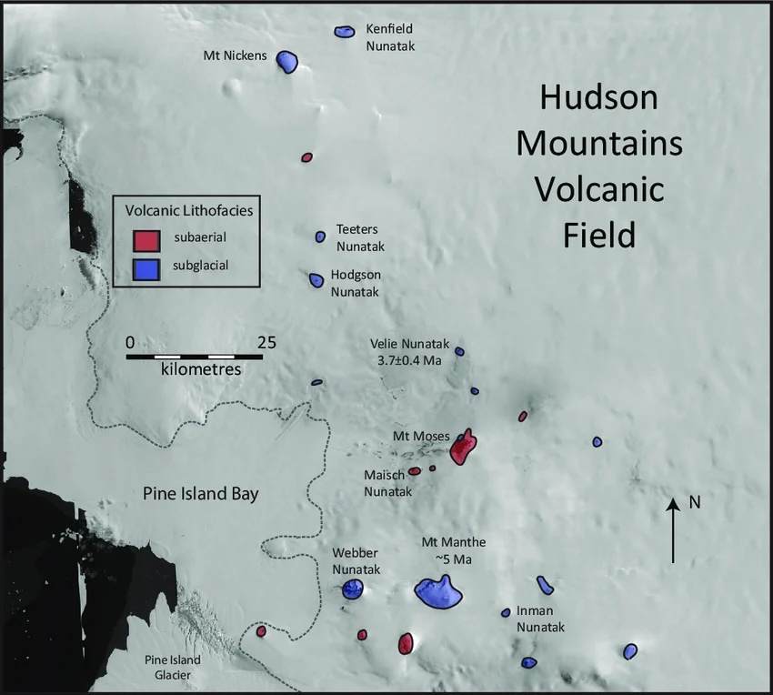
Hudson Mountain volcanoes. Source: Thomas Wilch, https://www.researchgate.net/publication/350073543_Chapter_54a_Marie_Byrd_Land_and_Ellsworth_Land_volcanology
The GVP mentions a satellite observation of the possible eruption at Webber Nunatak in 1985. This report is unsubstantiated. It is not mentioned in any publication I could find. Recent investigations on this nunatak have not reported any evidence of volcanic ejecta. The nunatak is volcanic but old. There is a seasonal meltwater pond on one side and it is perhaps possible this was (wrongly) taken as evidence for an eruption.
The tephra layer lies at a depth in the ice which corresponds to an age of approximately 2200 years. The age is consistent across the region where the tephra is found. The tephra is missing from the area of the Pine Glacier, but this is understandable because this is a fast flowing glacier. The age corresponds to a date around 200 BC, with an uncertainty of 250 years either way.
The eruption would have penetrated through the ice, ejection ash into the atmosphere and forming the tephra layer through air fall, later buried by snow. It seems likely that there was little wind at the time, as indicated by the elliptical shape of the tephra area. That would favour an eruption in the summer (Nov – Feb) as the winters here are windier.
This region in the highlands of Ellsworth has slow ice movement. The typical flow rate at the surface may be 1 to a few meter per year. Over 2000 years, the ice would have moved by no more than a few kilometers.


Ice flow rate on the surface derived from Copernicus data ( https://soaratlas.com/maps/ice-flow-velocity-on-the-antarctic-ice-sheet-2014-2024-140709)
The image above shows the measured surface flow rate of ice. A similar figure is presented in the paper. The tephra layer follows the dark blue area where the ice flow velocities are lowest. But further away the ice speeds up considerably and the velocities are measured in meters per day rather than per year. At 1 meter/day, the tephra could have moved by hundreds of kilometers since the eruption, and be lost to the measurements. The elliptical shape and extent of the tephra may just reflect the area where the ice is stable enough to retain this memory.
It is difficult to pin down the precise volcano that eject the tephra. The authors suggest it sits near the centre of the ellipse at a topographic high. They name it HMSV (not the most catching name, one must admit), which stands for Hudson Mountains Subglacial Volcano (which is not much better). The tephra volume is estimated at around 0.1 km3 but with a very large uncertainty (and some of the tephra may be lost.) Think VEI 4, operating very similar to Grimsvotn. This could be the largest Antarctic eruption since Deception Island blew up.

The ash-covered glacier of Eyjafjallajökull after its eruption:
Antarctic ice cores are used to detect sulphate from eruptions around the world. Could they show such a local eruption? The two nearest ice cores were taken 1000 km away, so for a smallish eruption this is not as easy as it sounds. But both ice cores have a strong peak around 320 BC. This peak is not seen at ice cores elsewhere in Antarctica, and it is therefore a candidate for the Hudson Mountains eruption. Full evidence would require tephra and this has not yet been reported from these two ice cores.
The Hudson Mountains are adjacent to the Pine Island Glacier, a fast glacier which is one of two which could destabilize the West Antarctic Ice Sheet. (The other one is Thwaites Glacier) Active volcanism close to these glaciers was not known before. The eruptions themselves won’t damage the glacier. However, melt water from an eruption could cause the Pine Island Glacier to slide even faster. The much larger Thwaites glacier is safe from Hudson Mountains melt.
But perhaps this has already happened. Sea water near the the end of the Pine Glacier shows an excess of 3He, which has to come from melt water underneath the glacier. It indicates that the glacier is receiving this water from a volcanic source underneath the glacier or its tributaries. It requires a volcanic source not dissimilar to Grimsvötn. The Hudson Mountain Volcano would be a plausible source for this.
Past and Future
Once global warming removes the West Antarctic Ice Sheet, a lot of volcanoes will see the light of day. The pressure will be off – but this pressure from the weight of the ice may be suppressing eruptions at the moment. When the ice age ended in the north, Iceland’s volcanoes became very active. When it ends in the south, will the same happen?
Antarctica is in so many way the antipode to the Arctic. Land versus sea, Ice versus water, continent versus ocean. And now we can add volcanoes: whereas the Arctic is a volcanic desert, Antarctica is an oasis. One we didn’t know existed.
Every story about Antarctica has to mention Shackleton. His expeditions became legendary: they were about battles of survival, knowing when to put people before ambition and bring them back safely. At his first run to the South Pole, Shackleton came to within 200 km of the pole (and was the first to reach the high polar plateau) before deciding that supplies were insufficient to go further. At his second run he never even set foot on the continent and lost his ship – and still got everyone of his companions safely home. That is the kind of failure that the English (and perhaps the Irish, as he was of half Irish descent) could value. His stories include a volcano: his men were the first to ascend Erebus. But there is another link to the story here. While Shackleton’s ship was caught in the ice, floating to destruction, he wrote seeing an iceberg with a dark band embedded in it. Exactly what this was is not known. A volcanic eruption is one possibility. Could this have been the tephra layer from the Hudson Mountains eruption? The Weddell Sea may be a bit too far (and Deception Island is rathe closer) – but it is nice to think so.
Albert, September 2026

Mount Erebus. The lonely mountain alone no more


Wow! Fascinating reading! Thanks!
Agreed. Antarctica well explained for us. Thanks.
Minor typo should say, only in 1948 was it shown that **EAST** antartica and west antartica. Going back to read the rest of the article now 😀
Plus, also minor, maybe Terra incognita instead of incognito, third paragraph.
Thanks. There will be more typos to be found! I’ll fix them when I can
Kilauea has started a dome fountain. Visibility is poor, but you get a glimpse every now and then on the V3 cam.
I was a bit quick to comment. There have been several overflows and the tilt has gone down. There might be another DI starting, so the main show could still be delayed a couple of days. Let’s hope it’s delayed at least until the weather clears.
Nothing like Nyiramuragira in Antartica I guess the plume under there is not as powerful as the african one
I’d say it has more to do with ice. From piece:
“When the ice age ended in the north, Iceland’s volcanoes became very active. When it ends in the south, will the same happen?”
You can see what Sweden looked like 11.000 Years ago. Vänern like Vostok. But oh, no volcanoes.
Lake Vostok and others:
https://discoverwildscience.com/the-lake-hidden-under-antarctica-secrets-beneath-the-ice-sheet-3-335031/
It might explain how life survived Snowball Earth
That and hot geothermal vents among ocean ridges where life refugees during global freezes. Waiting for CO2 from volcanoes to buildup in the atmosphere ending the freezer.
On Mars thats 1/9 th the mass of Earth there is no constant volcanic outgassing ( only sporadic eruptions every few million years) due to its smaller cooler interior that locked Mars in a permanent Ice Age long ago as its not good enough to recycle its carbonates
Just wondering: Are there hydrothermal vents at the bottom of Europa’s ocean?
Current thinking is no. The tidal heating on the interior of Europa is too weak for that.
Where the last spike on the right hand side is located was 90 Ma, Cretacious Thermal Maximum, Antarctica green.
In case the trend today is not reversed the following would happen: Chile, Argentina, New Zealand, Australia (Heard Island) and the UK (British Overseas Territory) would claim it, the US and China would wage war and take it away from them.
Should stay frozen as long as mankind exists and wages wars.
IF Earth had a denser atmosphere ( say 2 bars and lets adjusted orbit ) for heat balance the denser air woud even out the temperature diffierences between poles and the equator. With this imaginary setup the pleistocene ice ages may have never had begun even for the same given temperature and co2 contents as ice ages had in real world with 1 bars pressure. A denser air 2 bars evens out temperature extremes and makes Co2 more powerful per ppm compared to 1 bar.
Souch an alternative Earth maybe always be a greenhouse world covered in tropical forests even for the same global temperature as holocene haves with 1 bars pressure
In terms of exoplanet habitability this opens up a golden box of possibilities with life evolving and thriving under a higher air pressure and more stable climate conditions than earth haves.
Depends what you do to the atmosphere. If you just add more of the same, you’d double the greenhouse gasses and temperatures would go up by 5-10 degrees C. But in reality CO2 is limited by the carbon cycle and you are not adding more carbon to the Earth. Neither would O2 obviously change (in fact I would recommend you don’t – double the oxygen would not be healthy and rather fire prone), So I expect you would just add more nitrogen and that may not make that much difference. Much stronger winds could be a problem – I recommend evacuating Florida.
Poor Tallis
In this case orbit is adjusted to balance the greenhouse effect. The temperature less differences between poles and equator means less strong global winds
( thats saied hurricanes can be strong yes ) those are driven by heat from below
This model works perfectly in sicence models of Superhabitable exoplanets
Just rotate the axis so the pole points “sunward”. Then everyone gets a nice dose of sunlight once a year (and dark once a year). No ice but might be windy ….
Its clear the habitable zone is actually quite wide, depending on atmospheric depth, surface gravity distance from the sun and the radiation from the sun (ie size/temperature). For more exotic life, might even be wider still.
Put venus where mars is and it might be quite nice.
A denser nitrogen atmosphere haves lots of benefits as long as you balance the greenhouse effect ( insolation ) souch an Earth will get a more even and more stable global climate than we haves in reality. This is confirmed in studies of simulated habitable exoplanets
Its barely possible to imagine a living world with thinner air pressure than Earth haves today: thin air means a very harsh climate and temperature gradient
The default atmosphere for a terrestrial world is CO2 with a few percent N2. To get an atmosphere like Earth (or Titan) it is necessary to remove the CO2. On Titan, it froze out. On Earth, rain and oceans did the job.
The habitable zone is not that easy to define, because it depends on conditions on the planet. Indeed, it can be quite wide. The problem is stability. A change in local conditions, e.g. a change in CO2 or cloud cover, can push a planet into being uninhabitable. Snowball Earth was uninhabitable to complex life – and humans are quite complex. So even on Earth, long-term survival of life was never guaranteed.
A denser nitrogen atmosphere extends the habitable zone alot and souch planets maybe near constant eocene jungle worlds…thats possible with higher air pressure and lots of volcanic outgassing from an exo Super Earth
This is just a dubble of Air pressure ( nitrogen ) and that works very well on true sicence models on possible Superhabitable worlds elsewhere in the galaxy
Concerning the pressure: I once read somewhere that the pressure was higher when the dinosaurs were alive. Is that possible?
Chilean National Museum of Natural History, Antarctopelta belonging to the Ankylosaurs, length up to 4m, source wikipedia
https://theconversation.com/how-the-event-that-killed-off-the-dinosaurs-wiped-out-life-in-antarctica-60265
“Some of these lakes may have been isolated from the outside world for up to 35 million years, and may be final refuges for life, the like of which exists nowhere else on Earth.”
https://www.antarcticglaciers.org/glacier-processes/glacial-lakes/subglacial-lakes/
That was after the Tasmanian Gateway and then the Drake Passage opened.
Other exoplanets ( Super Earths ) say an imaginary living world with 2 bars of Earth pressure will have many advantages over Earth. The temperatures and weather gets more even and less varied and more stable with a denser air mix that evens out and holds on to heat better ( as long as the greenhouse effect / orbit insolation is stable )
Souch a planet may always be a warm cretaceous greenhouse due to its denser atmosphere and its more active volcanic geological carbon cycle .. no ice ages
I dont buy “rare earth hypotesis”
at all
A deep atmosphere and higher surface gravity will at some point make chemical rockets unusable to get into orbit above the atmosphere. For spaceflying species to evolve, a low surface gravity and shallow atmosphere makes it easy.
Carbon is particularly good, though, with a gaseous oxide that recycles the element. Silicon might be more tricky, although I guess rocks are always available. Silicious life running on some sort of hydrofluoric acid (bound somehow) anyone? A particularly aggressive lichen?
On a Super Earth the denser atmosphere will be closer to the ground the atmospheric height will be same as Earths or even less than our own atmosphere or only sligthly higher with 2 bars
Very extended atmospheres are more a thing of low gravity worlds like Titan that haves dense atmospheres
I will never buy rare earth theory
It is on special offer. Buy one – get .. one
That Earth perfect theory is getting alot of criticism.. infact some Super Earths maybe superhabitable if the conditions that Earths haves exists there: their geological engines and sillicate carbbon cycles will runn fur much longer than ours will on our smaller Earth
Thats saied nothing like that have been found yet: our resolution of exo Super Earths are too poor despite their 100% existence
Thanks for the virtual expedition to Antarctica, Albert!
Antarctica is an important climate machine of the present Cenozoic Ice Age. The isolation of the continent on the south pole and the “Circumpolar Current” helped to cool the climate significantly since Oligocene 34 million years ago. The current human climate change will cause a temporary exception fo this mechanism, but won’t move the continent Antarctica to anywhere else. So it’s likely that after the end of our Greenhouse emissions the climate will slowly stabilize and later go back to a relatively cool mode after some thousand years. It’s good for the climate that a lot of CO2 is bound in Limestone that can’t be burned like coal or oil by the industry.
https://en.wikipedia.org/wiki/Oligocene#Eocene-Oligocene_transition_and_Oi1_event
Originally Antarctica, Australia and South America were one continent. It’s difficult to imagine what type of animals lived there.
Something like opossums? And other marsupials.
I imagine that also Cangaroos or some predecessors of them lived there. Maybe with a much higher population than we had in Australia 1800.
From https://www.bas.ac.uk/data/our-data/fossils-from-the-antarctic/
“Antarctica today is a cold, inhospitable desert; however, in the more distant past, the climate was much warmer. Abundant finds of fossil leaves and wood point to the existence of extensive forestation in earlier geological periods, even to within a few degrees of latitude of the South Pole itself. Dinosaurs, and later, marsupial mammals once roamed across its surface.”
See also: https://en.wikipedia.org/wiki/List_of_fossiliferous_stratigraphic_units_in_Antarctica
and: https://en.wikipedia.org/wiki/Category:Fossils_of_Antarctica
Even better: https://en.wikipedia.org/wiki/Antarctic_land_bridge
That maybe the default setting for antartica IF earth had more air pressure: a warmer and greener world than with just 1bar
The real cause was high co2
Had Earth had more air pressure then the freezing of antartica may have never happened ..
Whats the coldest volcano in antartica is it Mount Sidley?
During Ordovician Gondwana was an Antarctic continent like the present one, but much larger. The current lands of Africa and South America were around the South Pole position. Avalonia and Armorica divorced/diverged from Gondwana and moved north over the globe towards the northern hemisphere, where they built Europe together with Baltica.
The current active rifts in Antarctica mirror the desintegration of former mega-continents like Gondwana in the same region.
When I was still a child or a teenager I got a book for Christmas about the Terra Nova Expedition of Robert Falcon Scott, his third expedition to Antarctica. His and his mens fate greatly moved me and still does.
It seems that it was this man’s fault:
https://en.wikipedia.org/wiki/Cecil_Meares
He died in Victoria, BC, Canada, in 1937, 60 years old. He must have died of guilt.
If he had taken the dogs to the meeting point all with the exception of Edgar Evans, who died of frostbite and consequences on the foot of Beardmore Glacier, would have survived. Beardmore, an enormous chunk of ice and snow, was first climbed by Ernest Shackleton.
The other four made it to the meeting point with the dogs, but no dogs there. This was accompanied by a sharp drop in temperature, and due to the slow progres they ran into a fuel shortage.
This is such a sad story.
Grotto in an iceberg, found on wikip. article about the Terra Nova Expedition.
Maybe it wasn’t for the British:
“The party’s mastery of the use of skis and their expertise with sled dogs ensured rapid and relatively trouble-free travel.”
From wikipedia article about Roald Amundsen.
The clouds on Kilauea have mostly cleared. There are periodic overflows and flaming. The DI event is still continuing but once it ends, the next episode might occur very quickly
Fire (Kilauea) and Ice:
Amundsen discovered the glacier which he named Axel Heiberg-Glacier. He did s.th interesting here:
“Roald Amundsen’s “Butcher Shop.” It was here in November 1911 that his party slaughtered their excess sledge dogs, consuming portions themselves and permitting the remaining sledge dogs a feast, prior to making the final dash to the South Pole, which was reached December.
https://en.wikipedia.org/wiki/Axel_Heiberg_Glacier
He killed about half of the dogs, not without regret>
“[T]here was depression and sadness in the air; we had grown so fond of our dogs”. Regrets did not prevent the team from enjoying the plentiful food; Wisting proved particularly skillful in his preparation and presentation of the meat. –
He took 18 well-fed dogs with him to the pole and left a depot with meat for the return voyage.
It looks like the dogs saved Amundsen, and the Scott Party died because of not having them.
He seems to have had a good sense of humour:
– On 4 December they came to an area where the crevasses were concealed under layers of snow and ice with a space between, which gave what Amundsen called an “unpleasantly hollow” sound as the party passed over it. He christened this area “The Devil’s Ballroom.”
https://en.wikipedia.org/wiki/Amundsen%27s_South_Pole_expedition
https://en.wikipedia.org/wiki/Axel_Heiberg_Glacier
So, sled-dogs, friends and helpers of mankind, made the difference.
The ascent of the polar plateau is very hard. The plateau forms a steep escarpment in which a few glaciers have formed the only access routes. Amundsen discovered the Axel Heiberg glacier which was on his shortest route (he discovered it after a difficult climb up a different route ended at a ridge and a view of the glacier below). It is very hard, with very few passable routes, ice falls and slopes (on ice!) of as much as 45 degrees. Perhaps out of exasperation they did the final 30 km (and almost 2 km climbing!) in a single push. The dogs crawled, digging their claw into the steep ice, exhausted. That night, on arrival, 24 of the dogs were killed. It was a common practice at the time for polar travel (although not one used by the British who even tried ponies!). They stayed there for four days before being able to continue.
I think that if they had known, they would have chosen a diversion to another glacier – that is the problem of being the first!
And after that, they went through a 1km deep basin which, if the area had been mapped, they could have gone around.
Thank you
OT: Nasa published some neat satellite images of the ongoing eruption at Anak Kratau. I always like to see their ‘top view images’ of eruptions that are in the press, such as this one.
The accompanying article can be found here:
https://science.nasa.gov/earth/earth-observatory/anak-krakatau-rumbles-again/
Kilauea has begun with micro episodes (lava overflows from the north vent) that often precede the main episode.
At the same time deformation is even:
A similar (but shorter) phase occurred a week ago. It ended very suddenly. Yes, something has changed but it is too early to call the end. Curious.
August 26-ish’s deflation seems to have initially been quake-induced. A shallow quake occurred at the summit shortly before and for several months now these ones, how small they might be or in how few numbers, can (and often will) cause that effect on tilt. About a day after, a D/I occurred, depressing tilt even further – a rare (even the only?) instance where tilt was lower during the recharge phase than at the end of the episode. In any case it got out of that on the 28th or 29th. August 31 and September 3 appear to have been regular D/Is (the former less intense than the other); the latter’s inflation phase took tilt to the necessary level of starting an episode. Of note might be that August 27’s D/I occurred at about the time tilt would have been half-way recovered, were it not for quake-induced deflation, and August 31’s would’ve been around three-quarters or so recovered, with its inflation phase leading to the episode perhaps September 5 or 6 (interval of 11 or 12 days, pretty normal all said), following the route map of the past few episodes. I’ve also laid out my thoughts in this annotated UWD graph:
That aside, the one unfortunate part about the September 3 D/I’s inflation phase is that it lost steam right as north vent began pumping out lava, which you can see happening early on September 7. Were it not for precursory activity that started midday, I think it would’ve mostly held or gone up but slightly during this time. That immediately brings me to what I believe is (or was) the problem – only a bit of inflation is now enough to push north vent into overflow, but such overflow, given its volume, will immediately cause tilt to drop below the necessary pressure to progress to fountaining, keeping it in limbo. Fortunately it seems tilt is now able to overcome north vent’s overflows – if only a bit -, judging by SMC and SDH, so outlook good. The sparse overflows September 10 I’m inclined to attribute to quake-induced stalling (no deflation this time), which Volcanophil commented about earlier.
Whatever happens, I don’t think the average recharge rate will be to write home about, very far from, even.
There has occured a small earthquake swarm in the northern part of Kaluapele (Kilauea Caldera), where lava flows haven’t reached to since 2018. 1919 was a lava flow in this area. OBL seismometer is close to UWD and UWE and shows the earthquakes:
Its probaly that why the summit is flat.. but now the inflation seems to be comming back
No inflation yet. But the outflows are becoming stronger
While the tilt is mostly flat, the cross caldera GPS measurement is still increasing. I think another episode is likely to start soon.
Found this pretty film from 7 Sept:
https://www.msn.com/en-xl/money/general/glowing-lava-spills-over-at-hawaii-s-kilauea-volcano/vi-AA2c4rLg?ocid=msedgntp&pc=W226&cvid=6aa4f8ab2b84454091fb3987a82b1200&ei=25#details
Link doesn’t work, this can go, next one should stay, works fine.
Found this pretty film from 7 Sept:
https://www.msn.com/en-xl/money/general/glowing-lava-spills-over-at-hawaii-s-kilauea-volcano/vi-AA2c4rLg?ocid=msedgntp&pc=W226&cvid=6aa4f8ab2b84454091fb3987a82b1200&ei=25#details
This can go, posted twice
ignore, link works, first one doesn’t
Another development at Kilauea is that the Southwest Rift Zone Connector is seeing some swarming in its upper section. Seems the first instance in a while of magma flowing past the summit.
Also interesting the volcano-tectonic earthquake swarm, very shallow, in the northern part of Kilauea’s caldera, seemingly tracing some of the outermost faults of the 2018 Kilauea caldera.
The northern vent does weak Strombolian activity with occasional lava bomb spattering and Hydrogen flames (climate friendly). The tiltmeters show inflation now, so the next episode E55 may begin anytime today or tomorrow.
Yes, inflation has resumed and is well above where the previous episode occurred. But when inflation resumed, the overflows stopped.
I guess we are not the only ones waiting for the next fountaining event to start.
HVO writes:
The abrupt switch from summit deflation to inflation at the end of lava fountaining episode 54, glow from the vents, overflows, inflation, and continued seismic tremor bursts at Kīlauea summit indicate that another lava fountaining episode is likely in the next 24-48 hours. Inflation-based forecast models are no longer functional. The summit region has regained the amount of deflation recorded during episode 54 and is now several microradians over the level when that fountaining episode started. That, and the presence of magma shallow in all of the vents, indicates that current conditions remain favorable for the onset of episode 55 fountaining within the next 24-48 hours. Changes in inflation or eruptive patterns may cause the onset to be delayed.
In particular “Inflation-based forecast models are no longer functional” hits the nail on the head…
Manaʻo wau hiki iaʻu, Manaʻo wau hiki iaʻu, Manaʻo wau hiki iaʻu
😂😂😂
What an interesting piece about the Kikai Caldera. It needs a better picture on the main page. Catching up a bit and considering the picture boring I found the marvellous piece about a demon only now.
Sometimes when I’m bored, I’ll have Gemini simulate thousands of years of hurricane/tornado seasons – incorporating extreme atmospheric edge cases – and output the most anomalous results. The results are, frankly, hilarious, and belong straight in a cheesy disaster movie.
The ones this blog will find most interesting:
4. The Caldera Vortex (Mount Vesuvius Slopes, Italy)
The Setup: A microclimate pressure trap inside the ancient volcanic crater interacting with a stalled maritime storm system off the Tyrrhenian Sea.
The Anomaly: A violently rotating F5 funnel that used the steep interior topography of the volcanic crater as a natural centrifuge, magnifying its low-level wind speeds before bursting out of the mountain flank and scouring tourist infrastructure near Pompeii.
9. The Volcanic Ravine (Reykjanes Peninsula, Iceland)
The Setup: A sub-surface geothermal heat anomaly interacting with a low-level arctic squall line off the Reykjanes ridge.
The Anomaly: An EF5 vortex that formed directly over active fissure fields, entraining superheated volcanic steam and gas into its core while completely pulverizing hardened basalt lava fields into fine grey dust.
I assure you that I did not mention volcanoes when I prompted the simulations, nor did I expect them to turn up.
It seems that Gemini has read our posts and comments on volcano tornadoes!
Erebus lava lake in Antartica the worlds only convective phonolitic lava lake it haves a viscosity about 100 times higher than the lava flowing in halemaumau
The Azores have put a “yellow” alert level (V1) on the volcano Furnas on Sao Miguel: https://www.portugalresident.com/azores-volcano-alert-raised-due-to-increased-activity/?fbclid=IwY2xjawUPxOJwZG9mBWV4dG4DYWVtAjEwAGJyaWQRMFFQQnBVZFNNUmRjdDNvaGhzcnRjBmFwcF9pZBAyMjIwMzkxNzg4MjAwODkyAAEersaSgp2BT51kMYmHWdMdKrzyVNPsPeTEr8tlR3rRHSz5DaGf7OThd8ChSnA_aem_n_R3xTm6RzvsTGffvlylNg
Furnas is an explosive volcano. 1630 it did a VEI5 eruption, 1430 a VEI3, and 1441 a VEI4. So an actual eruption will likely be inside the span from VEI3 to 5.
On a side note. Back to Karakoram, sitting next to the Himalaya NW.
This is Concordia, the meeting point of Godwin Austen Glacier and Baltoro Glacier.
ttps://thumb.wikimedia.org/wikipedia/commons/thumb/b/b7/Baltoro_region_from_space_annotated.png/330px-Baltoro_region_from_space_annotated.png?utm_source=en.wikipedia.org&utm_campaign=index&utm_content=thumbnail
Pics from wikipedia
Little to no issues, a little melting, some surge.
What precisely is wrong with the Himalaya?
Maybe this:
https://link.springer.com/article/10.1007/s00376-024-4057-2
Been reading about hotsprings. Interesting: Ma’in Hotsprings Jordan/border with Syria. Between Madaba, an important cultural site with traces of the Umayyad Caliphate and the Byzantine period (mosaics), and the Dead Sea. Looking for volcanoes. Big volcanic field from the Miocene called Harrat-al-Sham:
https://en.wikipedia.org/wiki/Harrat_al-Sham
Nicely seen on the maps in here, 10 Ma, 5 Ma, 0 Ma. Pretty large, basically Igneous Province. 100 km from those hot springs as the crow flies.
https://www.volcanocafe.org/volcanoes-of-saudi-arabia/
Seeing this map from Alberts SA-piece I could imagine that there was a connection once between the Mediterranean and the opening Red Sea which was cut off by the uplift of the Arabian Peninsula. This opening would have been a part of the Tethys Ocean subducting there.
This piece ismore about the rift and West-Antarctica. I thought there must be some meteorite sites in East-Antarctica having been connected to Australia and also to South Africa, and yes there are:
https://science.nasa.gov/earth/earth-observatory/finding-meteorite-hotspots-in-antarctica-149554/
Setting 150 Ma:
Are there any up and coming analysis techniques that can penetrate and that can be used to image accurately under the ice? I know they used IFPA and satellite imaging mainly, apparently drones could be used also in future.
This is quite amazing:
“In March 2000, the 282-kilometre (175 mi) long Iceberg B-15, the largest ever seen at the time, broke off from the Ross Ice Shelf (Antarctic Climate & Ecosystems: Cooperative Research Center) and then suddenly broke up on 27 October 2005.
Research based upon measurements retrieved from a seismometer previously placed on B-15 indicated that ocean swells caused by an earthquake 13,000 kilometres (8,100 mi) away in the Gulf of Alaska caused the breakup, according to a report by the U.S. National Public Radio.”
https://en.wikipedia.org/wiki/McMurdo_Sound
And this is amazing too:
“As of 2018, four pieces remained that were large enough to be tracked by the National Ice Center (at least 70 km2 or 20 sq nmi). One piece, B-15Z, measured 19 km × 9 km (10 nmi × 5 nmi). It was located in the southern Atlantic Ocean, about 280 km (150 nmi) northwest of South Georgia Island. As it continued its move northward, the speed of melt increased. Most icebergs do not last long this far north.”
https://en.wikipedia.org/wiki/Iceberg_B-15
B-15 had broken off 18 years before.
Some more Tidbits:
This guy was with Shackleton when he lost the “Endurance” in 1915, the ship which was only seen again (under water) in 2022.
https://en.wikipedia.org/wiki/Thomas_Orde-Lees
He was attacked by a Leopard Seal, also Sea Leopard, and survived as another member of the team shot down the seal.
This seal is only the second largest, the largest being the Elephant Seal, but is the top predator of Antarctica preying on other seals, pups of the larger seal plus penguins. It is not endangered any more, estimates on numbers vary. After the end of whaling down there and due to the absence of other than research-based humans the species recovered.
Then we have Edmund Hillary who was the first to reach the summit of Mt Everest (with Sherpa Tenzing Norgay in 1953) and Vivian Fuchs who led the Commonwealth Trans-Antarctic Expedition (1955-1958) meeting at the South Pole from different directions in Jan. 1958, five years later.
So, Antarctica is full of wild life and already full of stories.
The amount of lakes under the ice would have prevented that the number of fossils represent the dinosaurs once living there – top predator being an Ankylosaur it seems). It must have been plenty.
A mysterious and fascinating very old piece of the Earth.
Map found here:
https://en.wikipedia.org/wiki/Commonwealth_Trans-Antarctic_Expedition
Can anyone explain the peculiar steps in the electronic tilt data for Kilauea lately? See https://www.usgs.gov/media/images/electronic-tilt-kilauea-summit-past-2-days. I have not seen this before. Is this gas piston slugs interacting with the magma flow?
This is definitely a new phase at Kilauea. The vent has been spattering continuously for the past 10 hours or so and is building a small cone. The tilt continuous to increase. If 10 hours counts as stable, then the expected stable phase has arrived and the fountains are past.
The current situation is that the magma is degassing at a constant rate and the lava level is no longer going up and down. The seismographs are also much more quiet and don’t show the phases of rising magma. My guess is that the lava level will slowly rise and spatter will increase until something gives.
Now both vents are spattering
Looks like we’ve got a third vent now, as well.
I’ve been a site visitor on an almost daily basis for the last couple of years. Not had a really good excuse to contribute before, but… I am going to be on the big island a couple of weeks from now. Looking forward to seeing *something* in person, though I’m not completely sure as to what that will be, of course.
Thank you all for your work, insights and resultant articles. I have, and continue to, learn a lot through your efforts.
Some ideas:
https://www.volcanocafe.org/visiting-the-big-island/
https://www.volcanocafe.org/visiting-the-big-island-part-ii/
Of note is that the third vent (west vent) formed by gradual collapse between episodes 53 and 54, rather than bursting forth during one. That vent would have been fairly long in the works and I therefore don’t see it as indicating anything in particular unique to either ahead of E54 or E55.
For the time being I’m maintaining that an unfortunate combination of events led to the delay of E55, beginning with earthquake-induced deflation shortly after E54 ended, thus throwing off the usual course of events during an episode interval as of late because tilt abruptly headed down rather than rapidly up as is usual. Then the inflation phase of a D/I ended (and tilt thereafter stalling) on September 7, while just at the point overflows had resumed. Any input would therefore be immediately converted to output, so no pressure could build. And when inflation did finally resume, it was rudely interrupted by yet another earthquake swarm shallowly below the caldera.
I recall a couple dozen intervals ago (when we had south still fountaining) there was a similar interval with erratic tilt movements (though I believe no D/Is, just earthquake-induced deflation or stalling). After the episode, the typical predictability returned, so I honestly think it’s far, far too early to say anything concrete about what happens post-E55 or calling it a “new phase”. To me it’s now just bad luck upon bad luck for Kilauea this interval.
SDH inflates some percent steeper than the Halema’uma’u tiltmeters:
Svartsengi still climbing, albeit slowly:


Earthquakes are still low (practically silent).
Langjokull however seems to be having a gradual increase in intensity.
As far as I see does Svartsengi still have more inflation than any other volcano of Iceland. The probability for an eruption within the next four weeks is higher on Svartsengi than on any other Icelandic volcano.
Hekla is a volcano that can erupt anytime as well, but I’d assume that the probability that it happens within the next four weeks is lower than an eruption of Svartsengi.
Really nice scoria cone forming around the north vent as steady splattering ends. As of 1700 GMT, it looks like the eruption may be ending? No hydrogen flame, as well as less visible outgassing from any of the three main vents.
V1 shows it best. https://www.youtube.com/watch?v=HggWKlZv9yk
Eruption #55 sure is following a different pattern. As others have noted, the situation remains very curious why major overflows were absent after several earlier minor outbursts that started nearly a week ago. In the past, overflows would increase once they started, then evolved into fountaining. And why the continuing inflation despite the opening of all the available vents that one would think would be de-pressurizing the upper reservoir/sill? Could the inflation be due to changes in the water table (i.e. note the water lake that formed about 1after the caldera lava lake drained in 2019-2020)? Maybe all the rain (4-6 feet) in the last few months (remember the Big Island got slammed last Spring in addition to the recent Hurricane hit(s)) has percolated to depth and had an effect by cooling eruptible magma or closed off some secondary feeder tubes into the main conduit? The inflation could be caused by steam, while the lower lava eruption rate is from reduced magma flow into the main conduit(s).
Also of note, is the water table when the lake formed was estimated to be around 0.7km deep based on old-data water well measurements made in 1973 plus other geophysical analysis’. Once the lava lake drained, the roof-collapse pit eventually dropped 500m then filled with water up to the water table. After the cooled walls of the pit reheated, they failed and the pit re-filled with lava and the water lake evaporated. So, what we do know is that there must be a large reservoir of water in the vicinity of the magma reservoir, with the current water table undoubtedly seeing a large influx of new water.
Let’s just hope that there are other forces at play other than water influx at depth to explain the change in eruption characteristics of episode 55. With magma ascension likely to continue, and more water expanding the water table, it doesn’t take an expert to know that increasing trapped water and magma at depth don’t mix.
Maybe a phreatomagmatic eruption is in the future? An interesting possibility.
Will be interesting to see if HVO puts out some thoughts on what caused episode 55’s odd behavior.
The cone is mostly quiet now but still (as of the time of this post) intermittently splattering. Will be interesting to see what USGS says in the new update.
I am concerned about all the degassing going on, which seems quite extensive. To me, this indicates that a lot more is close to the surface than just the 3 vents. The deformation keeps rising, and we see the pulses occasionally which push the tilt, then settle back down. I know that this is a hint, but we will find out later what this really means. https://www.usgs.gov/volcanoes/kilauea/science/monitoring-data-kilauea
I am wondering whether the conduit has widened close to the surface. That could stop the fountaining, and a wider conduit would dilute the gas pressure and thus stop the pulsing in the conduit. The pulsing stopped a day or two ago.
IIRC, that’s how the old overlook crater formed… widened and stoped upwards from below…
It looks like Kilauea has sprung another leak in the crater:
https://www.usgs.gov/media/webcams/f1cam-kilauea-summit-thermal-west-rim-summit-caldera-looking-southeast
Maybe the magma levels are so high now that alternative openings will be used to flood the crater floor…
It’s ironic that there actually was another leak, but on the other side of the crator. See comments below.
Catania Airport closed at least until 10pm
https://www.express.co.uk/news/world/2248307/mount-etna-live-eruption-sicily
Looks like my concern that episode 55 had ended yesterday was unfounded, with flames and spatter returning to the north and occasionally the south vent after a ~12+hr pause. Some outgassing and glow from the new west vent, but not seeing any spatter. The spatter and flames are near-constant from the south vent, and as of 1400 GMT, appears to be on the rise overall..though still no sign of any new overflows. Will need to monitor today to see if the eruption finally goes into overdrive or back to neutral? Also, I’m curious what will happen to the scoria cone? Is it going to collapse? If so, could it collapse into the main conduit and temporarily block the opening and allow pressure at depth to spike enough to trigger a more explosive event? My guess is the cone will just get disrupted and kinda’ disintegrate once the fountaining hits peak intensity, though a partial blockage would be cool to watch as the “nozzle” gets constricted with a corresponding increase in height (not necessarily volume) of the fountaining. Gonna be an interesting day from the looks of things.
Some earthquakes occured in the Keneakakoki region. Maybe an eruption there is possible like in July 1974, if pressure continues to increase.
Another scenario is that the caldera will get the shape of the 19th century. We’ve had the image and description once long ago in Volcano Café. There was a large, broad lava lake and many hornitos around it.
Cross-caldera length is increasing according to GPS:
Right now, V1 confirms some overflow is starting to breach the cone…in just the last minute, I can see the rim starting to erode. Very cool to see in real time. Start time is around 06:10.
Cool. Thanks.
Seems there was a fissure that opened earlier along the western edge of the 2018 caldera.
HVO mentioned these breakouts:
Kilauea Message 2026-09-15 07:53:05 HST
Two small breakouts occurred out at base of vent complex last night, feeding an active lava flow on the northwest corner of the crater floor. North/South/West vents continued to glow/produce spatter.
Looking at the livestream on the V3 camera, there is a glow between the west and north vents along the caldera wall that begins at 3:36 AM HST.
https://youtu.be/6r8JCz_cvaY?si=PKepQ1BVigYuuLiP
Shawn Willsey talked about it these new fissures.
Shawn got the location wrong, what he thinks is glow is just a reflection on sulfur deposits. The fissure was further down
I’m a bit confused. Is this really a new fissure? Or is this just existing lava under the crust that is being forced out by the increased pressure? Or at some point would this become a distinction without a difference?
SDH, 48 hour, live
Update: the fissure is still active and, looking at this seismograph, the tremor has increased. Might be that something might happen, or just normal…
HAT, 6 hour, live.
I have looked at all the other seismographs around the caldera and all show a similar trend of heightened tremor (with the exception of one ir two non-functioning ones). I just found this on the HAT seismograph. Is this normal?
Another odd thing is that the UWD tilt just started deflating, while the SMC has started to inflate. (Did not use SDH because it is not up to date yet)
SMC, past 2 days, live
UWD, past 2 days, live
SDH, 1 month, live
Finally got updated tilt for SDH and seems it is also uplifting, but it is also hard to tell as it’s a month long.
looks like a diurnal fluctuation
Areal view of the new fissures.
Image removed because of excessive size, and replaced with a low resolution version – admin
It seems that two of those vents are erupting at the moment, albeit passively.
I do wonder if the new vents have anything to do with the stagnation of the upcoming episode. It seems that, based on their nature, they could be pushing out the older magma because the pressure has become too great. I do still think that fountains could happen once enough old magma has escaped, but once again, Kīlauea can be unpredictable at times.
I wonder whether the new vents are just cracks in the solid lid, letting out the previously erupted lava below which is still liquid. If it was connected to the open conduits, the outflows would be much more vigorous.
V2 cam shows a stream of lava running down the caldera wall, so it’s not just leaking from the edge. There’s also a couple of incandescent spots even higher up that at some point produced some burning gas flames and occasional spatter. During daytime that area just looks like intense steaming far up on the caldera wall.
There was a sudden fountain a few minutes ago, much higher up and to left. It lasted only seconds and ended with a gas jet.
Maybe part of the magma from the complex has reached the old magma from previous eruptions in the 2018 caldera? That might be why the fountaining has stalled. The new magma may have to flush out the old magma so that fountaining might resume, if that’s the case.
It seems the vents are acting more similarly to the La Palma eruption of 2021, where higher and closer vents are more gaseous whereas lower and further vents are more magmatic, perhaps even passively emitting lava like now.
That’s the spot I mentioned 🙂
Lots of possible scenarios of what happens (or not) next.
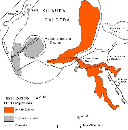
The position of the new effusive vent on the caldera wall is close to the fissure in September 1974. Three months before, in July a second fissure appeared in the Keanakākoʻi Crater: https://www.nps.gov/havo/learn/nature/july-1974-eruption.htm
 ?maxwidth=650&autorotate=false&quality=78&format=webp
Before the current vent opened, there were earthquakes both in the northern caldera and the Keanakākoʻi Crater area. It looks a bit like 1974. 1974 the eruption happened, when the summit had high magmatic pressure after Mauna Ulu and before the SWRZ eruption.
https://www.usgs.gov/volcanoes/kilauea/summit-webcams
The lava flow is extremely fluid and thin yet it seems to have a hard time moving foreward over the caldera floor its almost like its soaking into the porus fractured crust which woud not supprise me knowing how fluid this lava is, there are basalt dykes milimeters thick so it can find itself into the most tiny cracks in halemaumau floor. If this happens we will see internal growth and rise of the caldera floor again
IF this was Io then Halemaumau woud be perhaps 160 kilometers wide and have walls 2 kilometers tall
Fissure tectonic earthquake eruption at Langjokul. Died down now
“The United States starting under the leadership of Admiral Richard E. Byrd constructed a series of five bases near the Bay of Whales named Little America between 1929 and 1958. All of them have now drifted off to sea on icebergs.”
Wishing all the best for that gulf and the lake with the Indian name “Lake of Shining Waters”.
https://en.wikipedia.org/wiki/Research_stations_in_Antarctica
The vent has grown a baby cone
Some nice high spattering, from the newer vent. Happens occasionally.
It is a little hard to see, but the larger crack in the wall is now spattering. It is the bright spot on the left of the V2 camera.
Sorry this picture may suck!
So it seems that the magma has found an escape route up the edge of the caldera. Because it is leaking out in several places, it may be that it is moving between the lava/pumice layers of the vents and the hard rock of the caldera. The future is becoming unpredictable
The development may resemble Pu’u O’o’s jump of activity to Kupaianaha 1986, an escape from the first location of the tall lava fountains.
KW webcam sits above the active lava fissure: https://www.usgs.gov/volcanoes/kilauea/kwcam-live-panorama-halemaumau-west-rim-kilauea-summit-caldera-looking-southeast
This confirms my hunch that a lot more was just below the surface than the 3 vents
Here is a VC article of November 2018 about Kilauea’s shape and behaviour in the 19th century, when Marc Twain visited it: https://www.volcanocafe.org/hell-and-its-angels-at-kilauea/
Kilauea “was full of activity, lava lakes, outbursts, all at the summit.” It was a complex caldera eruption during the 19th century with lava lake activity, fissures and spatter cones.
It’s time to sum up the 54 episodes from December 2024 to August 2026. HVO has counted a total volume of the episodes of 312.6 million cubic meters or 0.31 km³. This happened within 20 months.
Compared to this Mauna Ulu I (1969-1971) lasted for 874 days = appr. 29 months and produced 0.19 km³. Mauna Ulu I had an average monthly lava output of 6.55 million m³, while the 54 episodes had a monthly output of 15.5 million m³.
With this monthly rate it would need only 23 years and 8 months to produce the volume of 35 years Pu’u O’o’ (4.4 km³).
There is now another vent active to the south of the spattering new north vent along the caldera wall, producing a second flow.
*third, because there’s another one further north.
… and another vent has become active along the caldera wall.
Big Island News has published a good photo with the new lava vent. The hot liquid lava mirrors the sunlight well and looks more bright than older lava:
https://www.bigislandvideonews.com/2026/09/15/kilauea-eruption-changes-new-vents-open-at-summit/?fbclid=IwY2xjawUXtH1wZG9mBWV4dG4DYWVtAjEwAGJyaWQRMHp3Tm1CZ1BzbHVjVnc2c0ZzcnRjBmFwcF9pZBAyMjIwMzkxNzg4MjAwODkyAAEeVvFQ58voST9iV3jhO-pA_AzW99zso4YqAaYnQGZHhLB_5j1IpnZDo-iqf68_aem_tldX3ficZBOhHshVEJJnCQ
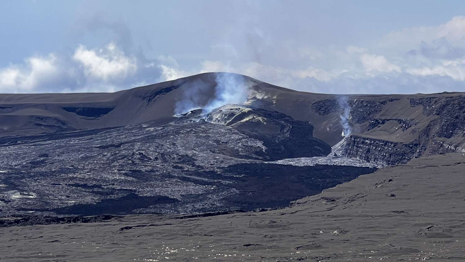
HVO: “Data from summit tiltmeters and Global Positioning Satellite (GPS) instruments indicate that the summit region is highly pressurized. This pressurization may be due to the increased height, about 500 feet (150 meters), of the north-south-west vent complex since the start of the eruption on December 23, 2024. The opening of new vents last night and this morning north of the established vent complex in Halemaʻumaʻu appears to be a response to this pressurization.” … “the summit region of Kīlauea summit remains at a high level of pressurization despite the opening of new vents last night.”
The pressurization of the summit repeats the situation of summer 1974, but on larger scale. 1974 magmatic pressure migrated from Mauna Ulu over the summit to SWRZ and stayed in the summit region for a transitional time. Today high pressure is not for a transitional period in the summit region, but part of a sustained focus of magma towards the summit. But the effect of strong magmatic pressure in the summit region may work the same way like 1974 and activate magma paths that were used then. We may get vents, where 1974 erupted for days, but this time for longer eruptions.
Forgive the OT interruption, and please do disregard if I’m mistaken, but IIRC there was once a post about the Galapagos volcanoes, specifically a potentially fatal eruption involving perhaps a ship being too close (in the days of sail ???) to a lava flow or something of this nature. I seem to recall it being mentioned; I may have missed this post with the pertinent information, and if so, would someone be so kind as to direct me to that no doubt fascinating read? If it is a post that has not yet been written, perhaps that will make an appearance someday. It would IMHO be an unforgettable one.
Thank you for all the work an effort of course that goes without saying, though it needs to be said (by me at least).
That did not ring a bell. We have covered the Galapagos twice, I think: https://www.volcanocafe.org/the-wolf-the-tortoise-and-the-plume-a-story-of-the-galapagos/ and https://www.volcanocafe.org/the-volcanoes-of-the-galapagos-islands/
There are many examples of people getting too close eruptions. White Island is an example, and there boats nearby were involved with the rescue.
It rings a bell with me though. VC had a piece about a volcanic eruption somewhere, and there was a science vessel nearby that was hit by a fair amount of ash. I don’t recall whether they survived. Japanese vessel as far as I remember. It should have been s.th. in the western Pacific then, not Galapagos.
Myojin-Sho, A ship foundered and sank after sailing over a subsea eruption. The density of the water decreased due to the erupted gasses and the ship was no longer buoyant.
Thanks, interesting
Page 129 and 130, Birth and Death of a Volcano. Ship got to close, eruption ended with Allegro furioso.
https://books.google.co.uk/books?id=3lIEAAAAMBAJ&lpg=PP1&pg=PA129&redir_esc=y#v=onepage&q&f=false
Corr. too close
I made a quick research in here for you and didn’t find it.
What I recall is someone mentioning in the comments section perhaps the fallout from Castle Bravo with a Japanese ship involved. The incident might also have been described in a complete piece.
https://en.wikipedia.org/wiki/Daigo_Fukury%C5%AB_Maru
I can see two possibilities
Krakatoa: A ship became covered in mud and ash in this eruption
https://www.volcanocafe.org/krakatoa-skies-when-the-sun-turned-blue/
Kolumbo: the entire crew of a ship perished in this eruption
https://www.volcanocafe.org/santorini-beauty-and-the-beast/. (near the end of the post)
This description taken from Albert’s Krakatoa piece shows quite clearly how powerful the eruption was. 75 miles is about 110 km:
“At noon the darkness was so intense that we had to grope our way about the decks, and although speaking to each other on the poop, yet we could not see each other. This horrible state and downpour of mud and debris continued until 1.30 P.M., the roaring and lightning from the volcano being something fearful. By two P.M. we could see some of the yards aloft, and the fall of mud ceased; by five P.M. the horizon showed out to the northward and eastward, and we saw West Island bearing E. by N., just visible. Up to midnight the sky hung dark and heavy, a little sand falling at times, and the roaring of the volcano very distinct, although we were fully seventy-five miles from Krakatoa.”
Very good piece with some colourful testimony, worth reading again.
This is brillant by Edvard Munch:
““it was as if a flaming sword of blood slashed open the vault of heaven,” he recalled; “the atmosphere turned to blood – with glaring tongues of fire – the hills became deep blue – the fjord shaded into cold blue – among the yellow and red colours – that garish blood-red – on the road – and the railing – my companions’ faces became yellow-white – I felt something like a great scream – and truly I heard a great scream.”
And that is what he painted, complete with the fiery red background.”
He heard Indonesians scream in pain, he imagined an enormous pain. Absolutely brillant.
It is one of my personal favourite posts
“volcanic winter causes five-year average world temperature drop of 1.2 °C (2.2 °F)” https://en.wikipedia.org/wiki/1883_eruption_of_Krakatoa
“The 1887 Yellow River flood in the Qing Dynasty was a flood in China that began in late September 1887 and killed at least 930,000 people.”
https://en.wikipedia.org/wiki/1887_Yellow_River_flood
Could it be that this was a follow-up of the demise of Krakatoa (caldera-forming eruption) after the so-called water-year in California from summer 1983 to summer 1984?
If yes the death toll of Krakatoa would be around a million (36.000 locally)
That number of 1.2C seems very high compared to other estimates for the impact of Krakatoa. It is normally given as less than 0.5C: this was a significant but not huge eruption. I would also have some doubts about a direct link to the water phenomenon, although an indirect one may be possible as California can be sensitive to long-lasting weather patterns.
A question please:
Seeing that the Magnetic North Pole meanders in the eighties north whereas the Magnetic South Pole is wandering in the sixties south
I wonder if this difference is explained by the solid thick ice further south.
There are different definitions of the magnetic poles. The one you refer to is the ‘dip’ pole, the place where the magnetic field points vertically down. The other definition is based on the axis of the overall magnetic field: this is called the geomagnetic field. The aurora, for instance, occurs in a band some 20 degrees away (and around) the geomagnetic pole. The geomagnetic North Pole is at 80.8 degrees north (somewhere in Ellesmere Island. The southern one is diametrically opposed. The dip poles behave quite differently north and south, because they are affected by small disturbances in the earth. The dip poles wander (at least kin the north – the south dip pole is much more stable), the geomagnetic poles are stable. The latitudes you mention are those of the dip poles
Thank you very much.
The great flood in California which had much of the central valley underwater, was in 1861. I think you may have your dates wrong. =)
Might interest you. Detailed paper from 2023 about the transformation of Tethys and Paratethys:
https://www.sciencedirect.com/science/article/pii/S0012825223002830
All major or huge natural disasters with a high deathtoll happen to be in this area.
happen to be in this area enlarged to the east, Nepal, India, China where subduction took place.
Plus list of open access papers from
College of Earth Sciences, Jilin University, Changchun
about eastern part
https://www.mdpi.com/journal/minerals/special_issues/397Q1RI2S3
Thank you all for the comments!
https://www.youtube.com/watch?v=gXKuUyKt8mc shows a grimacing face for the right vent as of 10 pm PDT Wed 16-Sept-2026.
https://www.youtube.com/watch?v=gXKuUyKt8mc
Right vent have become a little fiery frog / toad
Two glowing amphibian eyes and a big frogmouth!
And another DI event, albeit small – they do still happen
The new fissures in the caldera wall will reactivate once the inflation comes back up and the pahoehoe flow will get reactivated. The pahoehoe is behaving strange seems to be soaking into the crater floor moving only very slowly over the floor despite the constant output and rather fast supply the recent days from the new vents
Do Io s volcanoes have these inflation and delfation cycles too? I woud guess so
A question please, maybe stupid, better here so you possibly see it:
Seeing that the Magnetic North Pole meanders in the eighties north whereas the Magnetic South Pole is wandering in the sixties south
I wonder if this difference is explained by the solid thick ice further south.
Hilarious Albert:
“This film (Alien vs Predator) is well worth missing, and although set on Bouvet island, it wasn’t actually filmed there, so it is of no volcanological interest either.
The end of the world
Bouvet Island would be a good place to site the Restaurant at the End of the World. It meets all requirements, including a total lack of other customers. The main menu will be penguin omelet with an algae side dish, and the fumaroles provide just enough heat for the hot plate. Better stay indoors – because of the ice and the clouds, there is not much to see, making it ideal for people who have seen it all. And from experience I can confirm that a penguin colony smells atrocious.”
https://www.volcanocafe.org/the-island-at-the-end-of-the-world-bouvetoya/
Kudos for setting up a piece about this deserted place.
Btw, my younger son wanted to see videos before the allowed age, 16. So we got some, bit I insisted watching them with him. One of them we started in the middle of a Saturday night (“Once upon a Midnight Dreary”, Poe). I started shuddering and suggested that we watch the film Sunday morning which was much better. That film was “The Thing” by John Carpenter, worth seeing, but only in the daytime. Antarctica, scientists turning into aliens.
Update from HVO regarding the new vents:
Kilauea Message 2026-09-16 20:09:26 HST
Another new vent, vent 6, opened on the floor of Halema’uma’u crater just to the north of vent 5 and was visible just before 6 pm HST. The start of a small summit tilt drop around 5 pm HST may correlate with the opening of vent 6.
Looking at the cameras, it seems that the new vents “died” while the tilt dropped, but the main vents are still active. Is this just a fluke event, or is it a sign for things to come? There is no seismic swarm while the tilt dropped, so it seems magma isn’t going anywhere at the moment.
Update regarding shutdown:
Kilauea Message 2026-09-17 01:12:56 HST
The north-south-west vents have had consistent strong glow and flames all night. Summit tremor and tilt began decreasing around 5 pm HST and the new vents stagnated at 8:30 pm HST. No anomalous activity or seismicity detected elsewhere.
Glow from main vents has disappeared in the last 30min or so, could it be that magma has drained back into deeper storage areas as it couldnt keep up the supply?
nvm, clouds…im disappointed
https://watchers.news/epicenter/seismic-imaging-reveals-fault-controlled-volcanic-plumbing-beneath-lipari-italy/
News video from KHON2 News. Has some good photos and video of the new outbreaks.
New map:
https://www.usgs.gov/observatories/hvo/news/photo-video-chronology-halemaumau-overflight-and-maps-new-activity-kilauea
The glowing Hornito in daylight:
https://www.youtube.com/watch?v=HggWKlZv9yk
There was obviously some rain, so the whole lava field is steaming heavily and makes the visual observation difficult.
The Hornito does occasional small lava fountains … unlike the Strombolian lava bomb spattering that we saw the last days. Is it the small onset for an effusive lava eruption and new lava shield?
My potential post to this group was erased just now. This is discouraging. I believe that the discharge of water vapor from the caldera walls told all of us where the real magma pool was located. I am not surprised by the recent new vents. This is exactly what to expect if one follows the discharge out-gassing. There is an extensive pool of magma close to the surface, my personal opinion is that it is a sill, but yet, we still see elevation continuing. Whatever explanation, we must be able to account for the fact that elevation is occurring, despite active vents visible on the cameras. Kilauea is teaching all of us to be humble.