
The summit of Mount Everest, the highest point on Earth, is a sea floor. That may come as a surprise; after all, a sea should be at sea level. In practice, there is some flexibility on this. Three seas are below sea level: the Dead Sea, the Salton Sea and the Caspian Sea. All are salt water lakes which carry the name sea. There is a fourth one, the Aral Sea, which is above sea level. Its water surface (at least what remains of it, after one of the biggest environmental disasters of the 20th century) is currently 42 meters above sea level, and it can therefore claim to be the highest salt-water sea on Earth. It is still some way off Everest though. There is one fresh water lake which is called a ‘sea’: the Sea of Galilee, but it is also below sea level. Lake Baikal is called ‘sea’ by the locals, but not in its official name – if it did, it would have been the highest sea on Earth, at 455 meters. The highest fresh-water lake on Earth is reported to be the crater lake of the Argentinian volcano Ojos del Salados which is at 6930 meters. However, it is rather small, at 35 meters, and by definition should be called a pond rather than a lake. Cerro Tipas Lake at 5950 meters is the next best candidate. There are some higher bodies of water in the Himalayas but they are ephemeral. But every single one of them is topped by the summit of Everest. It is perhaps a bit sobering to think that people who sacrifice their fortune and potentially their lives in order to climb Mount Everest, end up standing on a sea floor.
A sea floor should be lower than the sea it floors. Clearly, things have happened here that turned a sea floor into the roof of the world. The story behind this involves the highest fossil hunting on the planet, and not one but two lost oceans. It shows how trilobites managed to beat Nepal’s famous Sherpas, by hitching a ride with a carrier, becoming cargo to the mountain itself.
The presence of marine fossils near the summit of Mount Everest has entered the domain of common knowledge. Many posts, articles, and newspapers state that sea shells are found at the summit. But few give the source of their information – it is just something that ‘everyone knows’. And there is confusion about the fossils of Mount Everest. Shells are commonly mentioned, of varying sizes. A few sites mention ammonites, and I even found one that claimed the presence of fish. Try to find the source of their information and you quickly hit blanks and dead links. Who did the fossil collecting? Most people climbing Mount Everest do not go there to hunt for fossils. Their goal is to reach the summit – not to bring down the mountain. On the way up, you don’t want to carry rocks with you. On the way down, your main aim is staying alive, while frozen and oxygen-deprived. Where are the fossils of Mount Everest? And what are those fossils?
Facts

First, let’s clear up some confusion. How did a mountain shared between Tibet and Nepal end up with an English name? You can blame the Royal Geographical Society for that. This was the age of the exploration, and what is the point of exploring if you can’t give names? Marquez’ master piece, One hundred years of solitude, describes when the world was so recent that many things lacked names, and in order to indicate them it was necessary to point. This was not the British way. Names were needed. Mount Everest had not been noticed at first as being particularly impressive. The exploring had to be done from a considerable distance, from Tibet, as the explorers were not allowed entry into Nepal. Foreshortening meant that other peaks appeared taller. In the 1840’s, the first indications appeared that a distant peak could be taller than any other. For a while it was called ‘peak b’, and later it became ‘peak XV’, but that wouldn’t do. When no local name could be identified, it was finally named after George Everest, Surveyor General of India. The pronunciation evolved, with the long ‘e’ becoming a short one, but otherwise the name stuck. The new pronunciation had a ring to it: it sounded like a special place.
However, unbeknown to the explorers, a Tibetan name was already in existence. It was Qomolangma, and that name is now often used. Nepal has since adopted yet a different name, Sagar-Matha. Pick your choice: whichever name you use, at least you no longer have to point.
And what about the height? Nepal and China, who share the summit, quote different numbers for it. Nepal uses the traditional 8848 meters. China claims it is only 8844 meters. The first number refers to the actual altitude climbers reach when standing (very briefly – there is a queue) at the summit. They are standing on 3-4 meters of snow. The second number gives the rock height which is a more stable way to measure a mountain – but it isn’t as high so it didn’t catch on. People who climbed the mountain from the Tibetan side would find their achievement listed as 4 meters less than those climbing the same mountain from Nepal. When spending a fortune, such details matter.

The 1924 Everest expedition. Back row, left to right: Andrew Irvine, George Mallory, Edward Norton, Noel Odell, and John Macdonald. Front row: Edward Shebbeare, Geoffrey Bruce, Howard Somervell, and Bentley Beetham.
But regardless of the name and the height, Mount Everest is a very dangerous mountain. The sheer number of people climbing it in the brief annual climbing season does not help. But the statistics of the mountain are sobering. For the Sherpas, the fatality rate is between 1% and 4% per year. Avalanches during the pre-season preparations are especially deadly. Almost 300 people have died on Mount Everest since 1950. Among them is the NASA astronaut and astronomer Karl Henize – but many other names could be mentioned. George Mallory, who disappeared near the summit together with Irvine in 1924, was born very near to where I now live. The chase of Everest connects the world.
The layers of Everest
The triangular mountain is instantly recognizable. If you haven’t studied the shape in detail, try this gigapixel view. But it is easy to miss the detail in the mountain. There are several layers. For instance, there is a region with inclined layered bedding, a bit below the summit, clearly visible at the bottom of the summit pyramid.

The second most famous pyramid in the world
The structure of the mountain is a bit hidden behind the snow. Sweep the snow away, and four main layers appear. The same layers are also visible in the other mountains in the area.

Source: http://www.earthsciences.hku.hk/shmuseum/earth_evo_08_2.5.2.5.php RF: Rungbok formation; ES: Everest Series; YB: Yellow Band; OF: Qomolonga Formation (Everest limestones)
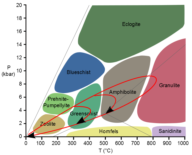
The layers are colour-coded in the drawing shown here. The bottom layer is colour-coded in brown, and labelled ‘LG+RF’. ‘RF’ stands for Rungbok Formation and ‘LG’ is a granite. RF is a gneiss: rock partly melted and metamorphosed under high temperatures (up to 500 C) and pressure, deep below the mountain. The granite was molten crustal rock from below which pushed its way up into this layer, much like granite complexes have done at the heart of every mountain chain. A low-angle (almost horizontal) fault separates the layer from the one above, which is colour-coded in green. This layer is called the Everest Series (ES), and it consists of sedimentary rock which has been metamorphosed at reasonably high temperatures. Above this, in yellow, is the so-called ‘Yellow Band’. This is the layered bedding which was mentioned before. It is a limestone, formed from a shallow marine sediment, heated to become a marble. Above this is another near-horizontal fault, and above this is an almost unmetamorphosed layer of limestone here called ‘QF’ for Qomolangma Formation, which forms the summit of Everest. The layers have moved around: the two faults are planes along which the layers have been sliding into their current position. The upper layers didn’t form exactly here, nor did they form in the same place. They are short-distance migrants.

Look at nearby mountains, and the same layers may be seen in the same order, although not at the same altitude. From south to north, the layers decline in altitude. The mountain building that pushed them up in the first place, caused by crustal thickening and intrusion of the granite, was strongest around Mount Everest but less severe further north. The fact that the layers don’t invert shows that in this location, the sliding was a simple process. There was no turn-over of layers as happened elsewhere, and as is seen in the Alps or Caledonian mountains. Around Everest, the upper sediment that has been least metamorphosed is always at the top. But few mountains are high enough to reach them: in most cases, erosion has removed this layer completely. There are nine mountains over 8 kilometer high in the high Himalayas. Of those, 6 still have a sedimentary layer at the top.
The Tethys Ocean
The top layers of Mount Everest are made from a marine sediment: a sea floor. But which sea? Or rather, which ocean? To answer this, we need to go back to the heady days when the Himalayas formed.
The Himalayas were a long-delayed consequence of the break-up of Gondwana. Australia, Africa, South America, India and Antarctica were all together in this supercontinent. (The world rugby competition between Gondwana and its northern-hemisphere counterpart, Laurussia, must have been a very one-sided affair!) Gondwana began to break up along the east coast of Africa where a fault grew into the Indian Ocean. In the process, a fragment was split off and became adrift in this new ocean. The fragment split further, into Madagascar and India. Madagascar stayed behind, but the fault behind India rapidly widened into an ocean and India was pushed forward, north. Between India and Asia was the Tethys: a worldwide, equatorial ocean running from China to Central America.

So India went across, closing the Tethys in the process and forming the Indian Ocean behind it. The seafloor that was uplifted and shifted to Everest was from the Tethys. It wasn’t the deep ocean basin: that was mostly subducted. The mountains grew from the continental shelf, and pushed up the sediment that was lying on it. The Tethys just disappeared. A few scars remain which trace the lost ocean. Some have already been mentioned: the Black Sea, the Caspian Sea and even the Aral Sea trace out the line where the ocean once was.
This is the basic view, In reality, things were a bit more complicated. I’ll come back to that.
Collision

50 million years ago India completed the crossing, failed to stop, and crashed into Asia. The collision happened in two phases. First, India hit an island chain. This was a volcanic island arc that had grown out of the subduction zone. The island arc left its sign in northern Pakistan. Later, India hit Asia, beginning in the northwest and ending in the northeast, in a drawn-out process. Originally, India had moved at break-neck speed, covering the distance at up to 20 cm per year. By the time of the initial collision, India had slowed down to 5 cm per year. This was still well above the speed limit for safe continental docking, though. The continental plate of India slid underneath Asia, and crumpled. The Himalayas are the crumple zone of that collision. The granite that forms the heart of the Himalayas consists of the Indian plate, melted at the high pressures at the bottom of a crust thickened to 70 kilometers.
The collision left India a lot smaller than it used to be. At 5 cm per year, India has lost 1000 kilometers over 20 million years. And still it is moving. It is hard to stop a continent.
So the Himalayas grew from below. In the process they pushed up the layer of seafloor sediment. Once the new mountains pulled in the rains, erosion attacked them. It removed the material from the top. In consequence, very little of the old seafloor that formed the upper reaches remains: only those 6 of the highest peaks just reach the Tibetan marine deposits. The rest of the old sea floor has been carried away by the giant rivers of the Himalayas, and returned to the Indian Ocean.
Fossils
The ancient sea floor will have incorporated the organic remains of ocean life. Fossils are relatively fragile: they can survive a modest amount of heating of the rock, although it may push then out of shape. But there are limits. You expect fossils in sedimentary rocks and in mildly processed metamorphic rock. By the time the rock becomes greenschist, any fossils will be gone.

A schist from high up on Mount Everest. Source: https://palaeomanchester.wordpress.com/2017/12/14/reaching-new-heights-with-collecting-everest-specimen/ It was collected at around 8 km altitude and that is impressive enough. But it is a schist and as such contains no fossils.
The lower layers of Everest are indeed greenschist, and are not great for fossils. The granite was injected from below and has been through worse: no fossils here. The Yellow Band is a marble, heated enough that only microscopic fossils may be left. The upper-most layer is limestone and although it has seen elevated temperatures and pressures, it remains suitable for fossils – if you don’t expect too much! It is found above 8600 meters.
The most interesting fossil rock of Everest will therefore be those nearest the summit. But they are also the hardest to get hold off. You can’t just jump on a plane to go collect an Everest summit rock! Luckily, we don’t entirely depend on the mountain itself: because the layers tilt downward towards the north, the same (or similar) rocks can be collected at slightly more reasonable altitudes. The Rongbuk Glacier in Tibet is such a place, and a lower layer is named after this location. But in the end, the fossil scientists wanted rocks from the mountain itself.
The first rocks from the upper layers were collected already in 1922, at an altitude of 8200 meters. More were collected in 1924, on the very day (and the same expedition) that Mallory and Irvine disappeared into the clouds. There were more samples collected over the next years, but many were stolen in 1939 and the notes describing them destroyed two years later. Expeditions of various nationalities brought back new rocks over the next decades.
The limestone is light in colour. It consists of layers of bedding, as narrow as a few millimetres, with alternating sand and calcareous (chalk) bands. The bands have colours varying from white to dark grey. The sand seems to have come from eroded granite: it was an erosion product from the land, brought down by rivers and collected in sand banks. It comes from mountains that came before the Himalayas, but how much earlier is impossible to tell.
Both the sand and the chalk contain fossils, tiny but clear. ‘Tiny’ here means that you need a microscope to see them: the sizes are something like a millimetre. It is quite a contrast with the size of the mountain!


Here are two examples, from the work of Professor Ganser, Geology of the Himalayas (1964) and reproduced by Noel Odell in 1974, in the Geological Magazine. (Click on each image to see the full resolution.) Odell was one of the original members of the 1924 Everest expedition. Both examples show fragments of crinoids. Crinoids are better known as sea lilies; their relatives include starfish and sea urchins. Sea lilies have been around since the Cambrian. Nowadays, they are found in deeper water, below 200 meters, but in the deep past they lived in shallow waters, and formed complete forests. Limestone beds can be made up entirely of such creatures: they were that abundant.
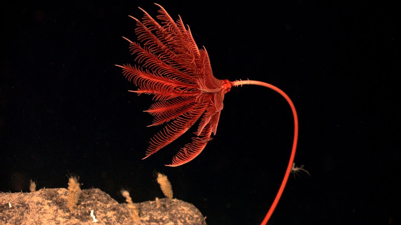
A sea lily, from the Gulf of Mexico. Organisms related to this one were abundant in the sediments that became the summit of Mount Everest. Photo: NOAA
Material from the Yellow Band has shown that it too contains up to 5% crinoid fragments. Other fossil fragments were found in the limestone: trilobites, brachiopods (lamp shells), and ostracods (small shrimps). Below about 70 meters below the summit there is a layer that formed from trapped sediment, 60 meters thick. The sediment was caught in a biofilm, probably from cyanobacteria (algae). This kind of bacterial mat is called a thrombolite, and forms in very shallow marine water. The thrombolite bed forms the bottom of the summit pyramid, including the ‘third step’.
The highest rocks that have been brought down were collected from 6 meters below the summit! They were collected in 1997 by a Japanese climber, M. Sawada; the analysis was published by Harutaka Sakai and collaborators. Two images from their work with fossil fragments are shown here.

The left image shows a polished slab of the summit limestone. The bar at the bottom is 1 centimeter. It shows bedding and faulting; fractures are filled with calcite. On the right is an enlarged polished surface showing crinoid and brachiopod fragments; the bar is 1 mm.

Left: grainstone with skeletal grains of trilobite (T), crinoid (C), ostracod (O) and fecal pellets (P). The bar is 1mm. Right: T trilobite fragments with the typical threefold arched shape. The bar is 0.1mm.
The Tethys and what really happened
How old are those fossil fragments? You might expect it to have the age of the formation of the Himalayas: some 40 million years. But no. The fossils are Ordovician to middle Cambrian, around 520 to 450 million years old. These dates have been confirmed by analysis of zircon grains of the Yellow Band. The sea floor, or rather the continental shelf, that became the summit of Everest was ancient! It was much older than the mountains themselves. The sediment had been on the sea floor for a very long time, before India came and scooped it up.
There is something funny here. The Tethys Ocean first formed around 275 million years ago. That makes the ocean considerably younger than the age of the fossils. Mount Everest couldn’t have come from the Tethys! The fossils lived when the ocean wasn’t there yet. The typical life time of an ocean is 200 million years: by that time, the oceanic crust has cooled so far that it becomes denser than the mantle below, and it begins to sink. A subduction zone forms which swallows the ageing ocean. The difference in age between the fossils and the Tethys correspond to this age. Mount Everest grew out of the previous generation of ocean.
Indeed, before the Tethys formed, there had been another ocean. Nowadays it is called the Paleo-Tethys. In those days, of course, the world was so recent that many things lacked names, and in order to indicate them it was necessary to point. Originally, Gondwana and Laurussia were separated by this Paleo-Tethys.
Around 290 million years ago, a fault developed in Gondwana. It became a spreading ridge and experienced intensive flood basalt eruptions. The area to the north of the spreading centre split off from Gondwana. It was a fairly thin, long fragment, consisting of Turkey, Iran, and Tibet. Behind them, the spreading ridge quickly became an ocean: this is what became the Tethys (sometimes called the Neo-Tethys). The flood basalt was carried with: the remnants can be found as the Panjal Traps in Kashmir. The cause of this early split of Gondwana is disputed. There is no strong evidence for a mantle plume. It may have been an older, passive fault which became activated when the old Paleo-Tethys began to subduct, and started to pull on Gondwana.

The fragment that included Tibet moved towards Asia, in the process closing the Paleo-Tethys ocean in front and opening the Tethys ocean behind it. 200 million years later, the process replayed itself. Again a subduction zone had formed as the Tethys was reaching the end of its life. Again Gondwana spit, this time terminally. India declared independence and started its journey towards Asia, chasing after Tibet.
The collision now occurred in stages. First, the remnants of the Tethys were swept up as the fragment of Tibet was driven into Asia. This formed the first mountain range, the Trans-Himalayas, around 55 million years. The range is still there: it lies north of the high Himalayas, starting from Kasmir. It runs parallel to it for over 1500 kilometers, with peaks over 7 kilometers high. The range lacks the clear structure of the river valleys of the high Himalayas. This is because it formed first, before the rivers were there. The rivers began to flow from the range, including the Indus. Immediately to the south, the Tethys-Himalayas were also uplifted. This included the old sea floor. The process here was gentle, with little metamorphism.

Next, India arrived. This collision threw up the High Himalayas, south of the Tethyan range. The Indus and Brahmaputra rivers were already there, flowing from the Trans-Himalayas and through the Tethys-Himalayas. Both cut through the newly rising mountains: you can see that they originate behind the high mountains, showing that they predate it. The rising was a prolonged process. The current high Himalayas were build on granite emplaced around 20 million years ago. The rising of the high Himalayas continued in phases, and is still on-going. India isn’t finished yet.

Source: wikipedia
The progressions of oceans is still seen in the Himalayas. The shore of old Laurussia became the Trans Himalayans. The continental shelf of the Paleo-Tethys was uplifted to form the Tethys-Himalayas. The new shore line facing the Tethys ocean became the High Himalayas, underplated by the Indian subcontinent.
So how did the Paleo-Tethys sediments end up on Everest? You may blame the near-horizontal fault that runs between the limestone of the Qomolonga Formation and the Yellow Band. It provided a low-friction contact. As the Trans Himalays rose up, the limestone layer slid down, towards the south. When the High Himalayas formed, the old Paleo-Tethys floor was ready and waiting. The mountains formed underneath it, sediment from an ocean that had vanished in the earlier collision.
Raising the roof
When you climb Mount Everest, you are not just reaching the summit of Earth. It is also a journey back in time. The mountain is young, as mountains go: the granite at its heart is no more than 24 million years old. One day, erosion will have taken it down to the level of this granite. But not yet. For now, remnants remain of the older surface that was here before the mountain grew up. The fossils, microscopic and broken down they may be, show that this surface is old as the mountains, by manner of speaking. They date back to the Cambrian. The Indian Ocean is the grand child of the ocean in which they lived. The fossils survived not one but two continental collisions.
The summit of Mount Everest is so much older than the mountain itself. It was deposited when even Gondwana was young. Climbing Mount Everest takes you to a time when life was young and many things lacked names. Even if the fossils are only a millimetre across – it is worth bringing some down, back to the sea where once they came from.
Albert Zijlstra, June 2018


A very disappointing development in the response to Fuego:
https://www.bbc.co.uk/news/world-latin-america-44393085
Opportunistic sleazeball politicians taking a page out of Italys BONEHEADED prosecutions of geologists for not predicting an earthquake.
FACT; geology is not an exact science. There is almost no way to measure the in situ stresses and failure threshold of rock hundreds if not thousands of meters below the surface. Just look at Hawaii’s HVO. They have been sitting on that mountain for years and have it very well wired with sensors, yet they still have conflicting ideas about how the internal plumbing is laid out.
About the best analogy for geology comes from quantum theorys Shrodingers Cat idea. You cant be exact in time and place for an event… the best you can do is a statistical GUESS.
And my pet survival idea comes into play. If you want to survive… Don’t be there. Fuego was a kmown violent system. You don’t need a government agency to tell you when to leave. You need a government agency to protect your stuff while you are gone.
Provided those agencies have the integrity to not steal your stuff,,, in that case, they should be drawn and quartered.
I like “statistical guess”.
Two philosopphical thoughts:
1° When a physician says: survival probability is 80%. What does it mean for one peculiar human being 5that belongs to the 20%….
2° Geologist, physician, etc. forget one fundamental rule in statistic:
—————————- HOMOGENEITY !!!!!!!! —————————–
LOL
Are volcanoes all the same?
Are two volcanoes the same? No.
Is any one volcano repetitive in behavious? No.
So live in the danger zone and realise its a danger zone. No priests or gods can protect you.
Geo, I watched a documentary on Java and people who live close to volcanoes, many are dirt poor, born to the place, have no money or way to live or go elsewhere. Many believe Gods inhabit the volcanoes and praying will protect them and in the end poor countries do not have the money to plan and execute massive evacuations and months or years of feeding a populace that cannot go back to their subsistence farms. Your thinking on this one is a bit harsh and doesn’t reflect the complexity of the problem.
I’m aware that not some, but MANY are tethered to their location by circumstances beyond their control. My vitriol is mainly directed at the opprtunistic filth that use their plight as fodder to advance their political gain. If they really cared about those people, they would be actually helping them rather than flapping their trap.
You see these subhumans all over the world. They will make you deaf from the intensity of their complaining but they will never do anything to actually correct the problem. If they did, they wouldn’t have anything to complain about. Their purpose in life would be lost if they didn’t have something to gripe about. Meanwhile, the Mk-1 mod 0 average citizen gets stuck out in the open having to fend for themselves in a hostile environment with little to no resources. Constantly preyed upon by the “well meaning” political hack that is just using them to advance their own political power base.
My other point was that even with top notch equipment and resources even the experts can’t fully agree with what is going on inside a well studied and monitored volcano. Thankfully (in Hawaii’s case) an effusive eruption is a bit easier to see coming. When it gets to the explosive events, those get difficult because you don’t actually know what the failure strength of the rock is or how much pressure is there. And once that first critical shard of rock breaks, the system as a whole cascades and the explosion occurs.
Correct.
I do sympathise, actually.
But only to a point.
Guatamala population:
1960 4.2M
2016 14.0m (yes 14, that is probably by now about 4x)
If you overpopulate your country, shit happens more often. However the main problem is you stay poor because all your resources goes to feeding your bigger population and nothing into education and development.
Victorian England, with their crazy stupidly altruistic protestant ideals, managed to more-or-less solve this and luckily USA and then Europe followed (after a few nasty wars).
Religion seems to be one key factor in controlling birth numbers often declaring birth control an evil. Another is the fact that families that are poor often have more children knowing that some children will fall prey to illnesses, in countries with poor health care access. children are needed to help with subsistence farming. Records show as a population becomes more assured that their children have a good chance of survival birth numbers actually drop. It does sadden me to see countries where leaders grab the collective wealth for a few and I have to say it is NOT just poorer countries that are experiencing that, look at my country of the United States and their new tax cut!
Shit happens. Fact. We have Grenfell towers, a classic example of building regulation failure from which we will hopefully learn rather than witchunt.
Two ways to deal with it when it happens:
1) Cast round for someone to blame, find someone, kill them, carry on as before.
2) Note something could have been done better. Cast round for those in the know and ask them to see how things could have been improved. Improve things. Kill nobody.
Humans naturally go for (1) because they have an innate (that is essentially pre-wired genetic) predisposition to animate everything. Hence the stick that tripped you up (no, you tripped up) and the animation of woods, rivers etc (often as gods). So clearly (using this as an example) the gods of the volcano are angry and the priests of the volcano failed to placate the god so should be killed. I think (reading slightly between the lines) its one reason why religions change. The Minoan religion vanished and I suspect a sequence of religions in Indonesia (only Bali remaining) from naturistic, through Buddhist to Islam.
Just swap one set of shamans for another, the priests live very well for a few generations then ….
(2) Is much harder to activate because it flies in the face of prejudices. Interestingly probably the only religion that preaches (as against puts up with) forgiveness is Christianity which is the vital clue to (2) although Hinduism and Buddhism can manage it too.
Go figure which will produce the best long term solution?
And all Lurks, that readnecked soab, comments are correct below!
This Post waxes lyrical. Thank You…… Best! Good Night with hopes for a better tomorrow, motsfo
https://www.youtube.com/watch?v=yE6iRgShVCE
A very clear view of the lava flow channel on kilauea. It is flowing pretty fast through about half of the flow now, fast enough to be incandescent. It also does appear that the lava level in the channel is a bit lower, but that could be because the flow isn’t ponded in that area as much and can flow more freely. Some of the wider areas of the channel seem to be narrowing and becoming faster too.
It really has a very striking resemblance to 4:52 of this video, except it looks like the flow rate from the video today is a lot higher.
The lava channel images make me think of this.
Wow what star is that?
zeta ophiuchus
That is the bow shock of Z Oph, yes?
zeta – not Z. Otherwise, correct.
Also this is a lidar scan of halemaumau taken the other day. It is quite different to say the least…
https://volcanoes.usgs.gov/observatories/hvo/multimedia_uploads/multimediaFile-2188.mp4
The deflation seems to have just about stopped now too, so the crater is probably not going to change too much more but some of the edges are overhanging so small rockfalls will probably keep happening for a while.
USGS says something else : A small explosion, with an equivalent earthquake magnitude of M5.6, occurred at 4.07 PM HST, generating an ash plume that rose to an elevation of about 10,000 feet. Since this small explosion, summit seismicity has dropped significantly, following the pattern of previous events. Inward slumping of the rim and walls of Halema`uma`u continues in response to ongoing subsidence of the summit.
There is ongoing subsidence, best seen at the caldera south rim (CRIM). Other GPS stations at Kilauea show still subsidence, but have slowed down past week.
Graph extracted from USGS HVO website, Volcano monitoringdata at Kilauea.
Updated 0606 18.34 HT 🙂
NPIT GPS still determined to get itself closer to the action for a better view.
It’s down even further at -9 metres on latest uncorrected rapid feed.
I think it fell in to be honest.
None of the other GPS show anything like that sort of drop and it is right on the edge of the old crater, so it is probably riding the landslide as it moves to fill in the deep pit.
Rob the GPS you linked to seems to show a continued drop but a lot of the other ones to the north and west are leveling off now, only CRIM and HOVL show continued drop, and they are quite close to each other so this could be the same. CRIM is near keanakako’i crater and the 1974 vents, which apparently has a shallow magma body under it which last erupted in 1982 only a month or so before pu’u o’o started. More likely that is what is deflating more than the main chamber now. That magma body is likely connected to the dike that fed to pu’u o’o so it would make sense that it would be draining. It is quite possible that a new pit crater will form in that area in the near future. This past few weeks have seen quite a change in scenery at kilauea, after about 95 years of looking basically the same.
I drew this overlay of what I am talking about. 1970s vents in purple, 1982 vents in light green. The red and orange is halemaumau as it looks now, with red being the overlook crater and orange is the landslide faults.
CRIM is the yellow dot. The magma body is the light purple circle (location uncertain but in that area), and evidently it has collapsed before as keanakako’i crater is there, so a new pit forming in this area wouldnt be that unusual really.
HOVL is some time off line I believe. The others are slowing down (as I wrote), but the subsidence takes place, in a pattern that matches with the tiltmeters and larger quakes. Some days show even a bit of an uplift if you look close enough.
In the USGS vid posted a bit above, dealing with the ongoing events Kilauea and Puu Oo, the spokesman states, generally nothing much in deflation and outflowrate has changed past weeks. Still ongoing.
In my believes, the upper magma chamber at about 3 km depth is still emptying. I think we are witnessing a slow caldera collapse. Collapses most of the time aren’t spectecular and happen in fases.
As USGS states, the 6 plus quake possibly has caused a change that caused the lava lake to drain.
I think hotter magma under the upper chamber may play a role too in the draining. Cooler magma has the inclination to sink in the hotter environment and the ongoing flow from a deeper chamber into the rift just takes the cooler stuff away.
I guess when the upper chamber has emptied enough subsidence of the calderafloor may stop. But will the eruption at LE stop at the same time. Unlikely. The change caused by the 6 plus has placed the rift in a new situation.
Eventually LE will stop. 😁
Not an expert, just volcanowatcher. ☺
I dont think the leilani eruption will last all that much longer, probably a few weeks before the vent shuts down and the thing stops, and I dont think this will lead to a total caldera collapse either, as other eruptions about as big as this one havent done that so why would this do it.
The summit subsided a lot during the 1960 eruption too, and a lot of the reason this subsidence now looks way bigger is probably because there was an open vent that collapsed and needed to be filled in. There was no open vent in halemaumau in 1960 so the collapse was more even and more hidden. In saying that though, the deformation now is definitely proportionally greater than in 1960, but kilauea was also probably more inflated before this eruption than at any other point in the last 180 years so it might have just gone from extreme down to average. It would be really useful if there was a continuous tilt record going back to 1955 so everything is really clear. I’m guessing everything after 1960 has been on a general upward trend and this eruption just sent it back down to the bottom again. ‘To the bottom again’ doesnt mean the same thing as going into dormancy though, or that this is nearing caldera collapse, the amount of magma in the summit chamber is probably 100 times bigger than what has been erupted so at this rate it would take years to form, with fissure 8 going at the rate it is now the whole time… The existing caldera probably formed from an eruption deep on the puna ridge far from land, there is a large lava flow at the very end that might be from that although dont quote me on that as it is probably unstudied.
If there was a large and fast 3 km3 eruption on land we would have found it, but the only eruptions of that sort of volume have been slow events like pu’u o’o, not fast rifting fissures.
The very end of the Puna ridge is around 5 km underwater I think that is out of range for the shallow system of Kilauea and I have also read that activity there is theorised to happen when a large caldera is already formed and the shallow system is basically inactive so that the magma is coming from deeper sources beneath Kilauea. The upper Puna ridge is thought to be old because of the sedimentary cover so intrusions like the current one do not have it easy to get that far.
Yeah, you are right about a collapse, 2 meters subsiding…. that is the average depth of a swimming pool! 😉 Time will tell where the emptying chamber will lead to. But again, Bardarbunga collapsed very moderate some years ago. That collapse was accompanied by many ringfault quakes. Sometimes, for a period of a day one can see a vague pattern of cracks surrounding the former lake bound by the southern rim. I didn’t find it clear enough to save a screenshot though. The northern part of the caldera is much less restless.
Do you know if there is/are a scientific report(s), article(s) about the size and “exact” spot of an upper chamber? If so could you refer to it?
“It would be really useful if there was a continuous tilt record going back to 1955 so everything is really clear.”
Since 1955. Out of luck. Will 1956 do? 🙂
https://www.researchgate.net/publication/252411181_Eruption_forecasting_at_Kilauea_Volcano_Hawaii
– Fred Klein, USGS
Although that’s only up to 1979 I think I read somewhere on USGS (or in a video) that actual original water tiltmeter is still in operation and still read and I’ve got a vague feeling I’ve seen a later version of that plot (that wasn’t pay-walled).
Yes it definitely exists.
https://volcanoes.usgs.gov/observatories/hvo/hvo_monitoring_deformation.html
Although modern electronic tiltmeters are more precise and provide continuous data, HVO scientists still measure one water-tube tiltmeter at the summit of Kīlauea to continue the decades-old record—the longest deformation record for any volcano.
I didn’t know there was a study done on the end of the puna ridge, but in either case it seems like it is harder for eruptions to happen there anyway. If you look at the submarine topography on google earth it drops off quite fast at cape kumukahi, and the ridge is about 400-500 meters deep only a few km out. That indicates a lot of dikes stop in the kapoho area so in hindsight that area really probably wasn’t the best location…
That also shows that eruptions there are infrequent, and that is supported by historical evidence as well as oral tradition. There is a report of an eruption in 1884 but it only lasted 1 day and was apparently in shallow water so it would have been way more obvious, and there were also no other signs of an eruption visible at the summit, like a drop in the lava lake, so this eruption might be dubious .
I knew there had to be a long term record of the tilt. I think that the overall inflation over about 8 years before now was about 1 meter, and there was probably more inflation in 1992-1997 and before 2002 so really the bottom of the 1960 drop might be lower than where it is now, and accordingly this is maybe not even close to a caldera collapse. Probably the observed collapse of halemaumau was mostly because of the conduit of the overlook crater vents collapsing and not from the deflation on its own. If it was collapse from depth then the area would be roughly circular and symmetrical but instead it is all lopsided and on top of that the western side is moving towards the deep pit which indicates it is not a ring fault but a landslide headland that mirrors the shape of a ring fault due to local stresses. The true collapse is roughly the same as in 1924 so not really gigantic.
It wasnt a study on the Puna Ridge it was more of a model of the general behaviour of the cycles of activity of Kilauea. There was an image of the east rift zone with a caldera in the summit and voluminous lava flows coming out of the end of the Puna Ridge so it might be related to that flow you were talking about.
This One?
I like that chart. It is reminiscent of the idea about the spacing of the Canary islands being due to crust flexure and the appearance of additional volcanic islands being at an inflection point.
Here is where it is (in page 344): :https://pubs.usgs.gov/pp/1987/1350/pdf/chapters/pp1350_ch12.pdf
Great post!
I remember a SciAm article from a few years ago that stated a midlevel layer of strata in the platform is “oozing” north and spreading out towards SE Asia.
From Global Tectonics, 3rd ed; an experiment ramming lucite blocks in the shape of the collision interface generstes sheer complexes almost identical to the known faults of the region. Additionally, the forearc basin fir the collision is the ganges valley/route. Sort of like the Arabian Gulf being in the fore arc basin in front of the Zagros mountains in Persia.
The Persian Gulf is also a consequence of the demise of the Tethys1
Good read as always, thanks Albert. Is that photo a bow shock in a solar system far, far away; or just a gas cloud shaped like one?
It is a bow shock. The star is moving through the interstellar gas and sweeping it up.
Still going under Pahala
https://earthquake.usgs.gov/earthquakes/eventpage/hv70243732#executive
M 2.7 – 4km E of Pahala, Hawaii
2018-06-07 13:10:59 UTC 19.207°N 155.440°W 31.8 km depth
If the earthquakes at pahala last year were the cause of the eruption now, then it probably takes around 6-8 months for magma to move into the summit, or push other magma into the summit. That would indicate that an eruption will probably happen some point early next year or at the end of this year as a result of the earthquakes now. It would most likely be in the overlook crater as that is the deepest point but who knows with how much of a change this is, it might be brief though, but probably a few of those will happen before more significant activity begins and the magma system is more established and re-inflated.
There is a not small chance that the highway 130 area will erupt in the next 10 years too. A small eruption happened not far northwest of that area in 1961, it only lasted 3 days but that would be enough to cut the highway pretty well for a while.
It would be interesting if an eruption happened on the west side of halemaumau (near or on the southwest rift) and lava cascaded down into it, very photogenic.
Well the sequence had a spurt in October 2015 with multiple 2 plus quakes in late October (and/or change in network sensitivity). Since then it has been producing regular 2+ quakes at a frequency greater than 1 per month with occasional bursts and slow downs but with the rate generally accelerating in 2016, 2017 and now.
So we’ve now had more than two years of elevated activity without a break at that spot.
That sounds like a pretty serious pulse of magma, and that probably also explains why the lava lake at the summit was sitting so high over that time, and why the draining of the lake after the 2015 flows had no real impact on the inflation of the volcano. The 300 meter deep summit pit could prove to be a very short lived feature.
Hopefully HVNP is re-opened when it happens so it can be recorded. People who look on google earth at the summit of kilauea now and go there in real life will get quite a surprise.
I really hope there is a timelapse of the cam on the Jaggar museum of the past week, it would be something else to be able to watch the solid ground just flow like that on such a big scale.
Here’s a 3d view of all quakes 2.5 and higher at depth below 10km since 2000 for roughly the southern half of the Island.
https://ds.iris.edu/3dv/index.html?caller=IEB&st=2000-01-01&et=2025-01-01&nma=2.5&xma=10&nde=10&xde=100&ob=mag-desc&li=1000&xla=19.67491868&nla=18.83091584&xlo=-154.89624023&nlo=-156.10198975&sbl=1&zm=9&mt=ter&sz=small
Generated from this selection https://ds.iris.edu/ieb/index.html?format=text&nodata=404&starttime=2000-01-01&endtime=2025-01-01&minmag=2.5&maxmag=10&mindepth=10&maxdepth=100&orderby=mag-desc&limit=1000&maxlat=19.67491868&minlat=18.83091584&maxlon=-154.89624023&minlon=-156.10198975&sbl=1&zm=9&mt=ter
Sample view
You can rotate the image etc. at the IRIS viewer.
There is a dense area of deep earthquake going southwest from Pahala towards Loihi were then all the earthquakes are shallow. Is there any chance that this earthquake swarm is actually related to Loihi or some other volcanic system south of the coast? There is some underwater volcanism just south and southwest of Pahala that I think corresponds to the continuation of the southwest rift zone i dont know it that could have something to do.
I meant to say southeast not southwest
In the IRIS there is also a branch of earthquakes going southwest though. In runs following the base at 3-4km deep of the Big Island mountain. There are some volcanics buried by landslide deposites in that area.
I think the bathymetry of the area might help.
We had been wondering about that. Pahala is better placed to supply Loihi or Mauna Loa (or both!). But the earthquake trace is there. Could it just be a coincidence?
I have read a paper that showed similar earthquakes to the ones at pahala were happening north of kilauea from 1950 to 1960, and apparently there was a deflation source at depth in 1924 that was 20 km east of kilauea so the feed area is really wide. Mauna loa probably has a similar system, and loihi is probably smaller right now but growing fast.
It is probably that magma can be sourced from the pahala mantle by all 3 volcanoes. It is also possible that it fed towards mauna loa from 1843-1950, then switched to kilauea after that.
Or maybe that is completely wrong and it didnt exist at all until about 5 years ago and this is a big surge of magma into the system, a warning that kilauea was going to do a bigger eruption and that an even higher magma supply would be the new norm for a while. If seismometers existed in 1790 they probably would have seen something like this too, heralding the start of 50 years of rapid caldera filling, and then ending with a big rift eruption again (maybe that will happen after this too). Maybe this is Pele getting ready to do some nice passive remodeling of her home after going to her favorite coastal retreat and finding out that people (re)built stuff there and that her last visit in 1960 didn’t sent a strong enough message…
‘A quick word to the people down the street’ 😉
Like this
(K= kilauea, M= mauna loa, L= loihi. Purple P is the pahala source area)
The depth in the mantle at which this swarm is taking place fits within the range of 27.5 km – 42.5 km where low velocitiy P-wave anomales exist under both Mauna Loa and Kilauea and from Kilauea extending south into a broad offshore zone so maybe the location of the Pahala swarm may really be a source for the three volcanoes.
And then
https://earthquake.usgs.gov/earthquakes/eventpage/hv70243932#executive
M 3.3 – 7km ENE of Pahala, Hawaii
2018-06-07 14:14:53 UTC 19.209°N 155.409°W 34.1 km depth
Hey, y’all: on the PGcam, on the horizon, about 30 deg to the right, (where the smudge is) the top of one of the shields seems to be venting something.
That shield is pu’u o’o, so it would make sense for a recently active area to be steaming 😉
I was guessing Ulu. Thanks!
It seems that while fuego had its big blast, pacaya has also decided to join in. It is only a lava flow though, so not much to worry about unless it slides down the slope and you are in front of it…
https://www.facebook.com/parquenacionalvolcanpacaya.pacaya/videos/2006666329366915/
Apparently this flow is going north so it actually could flow down the eastern side of the volcano, which hasn’t had lava flows on it since before the last collapse event 1600 years ago. Definitely something to follow.
Jökulhlaup expected from Grimsvötn, though not much larger than the one which happened last year http://www.ruv.is/frett/buist-vid-hlaupi-ur-grimsvotnum
Via Giggle Translate…
“Water leaks from Grímsvötn, but there is no hope of a larger run than has been in recent years, according to a report from the Earth Sciences Institute of the University of Iceland and the Icelandic Meteorological Office. The water altimeter at Gígjukvísl does not show a rise in water level or electrical conductivity, but it is expected that there will be a change in the afternoon.
“This is a long way that the water needs to travel under the glacier, so it’s far from reaching the water in Gígjukvísl,” says Kristín Elísa Guðmundsdóttir, natural resource specialist on duty at the Icelandic Meteorological Office. “We expect the water surface to rise and the running water will come down to Gígjukvísl, where we have a meal, the afternoon tomorrow.”
The jumps from Grímsvötn are well known and happen regularly, says Kristín. Last came a run from the lakes in August of 2016, but Kristín expects the race, which is about to start, to be as small as then. The water flow from Grímsvötn will be monitored.”
Man, Grimurs wife must have been really spiteful if her curse is still in effect.
Erupted volume so far according to USGS:
https://twitter.com/USGSVolcanoes/status/1004817496149352448
About the same as in 1960, despite none of the main lava fountains getting above 100 meters, interesting. Maybe that 500 meter fountain in 1960 was all show and not much substance.
This will be the 4th biggest historical eruption on kilauea, following pu’u o’o, mauna ulu and 1840. It is also tied with 1960 as the second most vigorous eruption based on the volume of lava erupted in the duration of the eruption, again behind 1840 which erupted double what this has done over the same time frame.
It is also the most destructive eruption that has happened in Hawaii in historical time… This is definitely a historic moment.
O no – not olympic sized swimming pools again. That is NOT an acceptable or even accurate measure of volume. And Hawaii does not have them..
Lava on the PGcam seems a bit gassy. Is it just steam from heavy rain or is there some SO2 as well?
Source for image: USGS
Today’s USGS update
https://youtu.be/7MaR9a78kyE
Embedded hopefully
Radio chatter indicates that there may be a breakout in progress. HVO is investigating.
For them that don’t know. Flowing magma tends to form a dike of solidified magma along the outer edge of it’s flow path. Over time, the magma sloshing up against the edges increases the height of the dike and deepens the channel. When a dike fails, the constrained magma can rush out and cover additional area sort of like a flood.
“rush” is a relative term. It really depends on how thick or thin and runny the magma is.
I’m assuming your use age of the word ‘dike’ refers to the edge of the lava channel, and not to the deep feeder system?
Yes. That is correct. It’s a tough word to use, it has so many different meanings dependent on context. I guess levee would be more descriptive, but the Corps of Engineers have nothing to do with it.
Update from HVO relayed on the radio traffic, the breakout turned out to be insignificant.
anymore info???
and You answered my question before i pused the post button…. man You are fast!
When I’m “on watch” I tend to operate like I did when active duty. Take the data, do something with it and get it out of the way. The faster you get your information to the correct people, the more easily you can process new data.
As for why I am ‘on watch,’ I’m bored. I’d like to have a thunderstorm roll through here, but those seem well off the coast right now. So, I sit and read updates and listen to the radio chatter. (actually not that different than standing watch in CIC)
I would get up and go smoke some more chipotle, but I’m out of peppers and I don’t like smelling like a house fire.
No, that was the actual statement “insignificant.” LE seem to be off looking at and talking about some roadway cracks. And elsewhere some lady with a BMW and a Dog are causing some consternation with a complainant.
{Moving this comment to the correct location in the comment chain was a risk, but I think I managed.} The risk is in screwing up the comment flow.
For the other moderators.. if it breaks, it’s my fault. I left it in the bin in case I need to take corrective action. Wait a bit before dumping it.
… and the entertainment of monitoring the radio chatter just gets better and better.
Police are investigating reports of a lady hiding in the bushes. They are not sure why, but everyone can see her over there hiding… evidently stealth is not her strong point.
My take on Kilauea explosions. Magma will always take the route of least effort. The chamber is sitting below the surface. Magma can rise up and go through the summit: that requires enough pressure to overcome the weight and strength of the rock. Or it can go through the rift, which requires enough pressure to force it open. At the moment, the summit reservoir was open so the pressure is limited to just the weight of the magma above the chamber. Because of the fault along the coast where Hawaii slumps a bit, the rift follows a line of natural weakness and does not require too much pressure. So the summit can’t build up high pressures, or the magma escapes through the rift. So, only limited size explosions are possible, and also the summit lava lake can’t get too high or the sheer weight will open the rift.
However, the fault runs along the coast, south of Kilauea. You still need a connection to it, and that is probably the weak (or rather strong) point. If that connection blocks, Kilauea can build up higher pressures.
The current eruption began with a blockage in the conduit of Pu’u’O’o. Pressure build up, and magma found the weakest point which was towards the east rift. Kilauea was not involved at this point as all the channels were open. Than the M7 happened and something broke. The coast slumped, stress in the coastal fault went to zero, and magma went for it. This did affect Kilauea as well which quickly lost magma to this new path. (A bit of common sense here: it only lost ~2% of its magma reservoir – the leak happened quite high up in the magma chamber). (I have no idea what that is in olympic swimming pools, the newly undefined HVO unit of measurement.)
The eruption will continue until the magna pressure becomes too low to keep the dike open, or until an easier escape route opens up. How long it takes the pressure to drop can be estimated by looking at the volume of Kilauea above the magna chamber (i,e, the area of the caldera). The heigh difference between Kilauea and Leilani is very roughly 1 kilometer. The magma chamber may be 1km2 in area, judging from the deflation pattern. If we use the rule of thumb that 20% of the magma makes it to the surface (the rest fills the dike: the number comes Holuhraun), and you get a maximum eruption size of 0.2km3. Once you get close to that, the eruption should get less.
This assumes no new supply of magma..
And a side note about the 2% figure that some twit at a news conference kept haranguing the scientists over.
GENERALLY, all volcanic eruptions will only release a low percentage of the available magma. Somewhere less than 10%. Just because 2% appears on the surface somewhere, that DOES NOT mean that there is 98% waiting to come out, or will EVER come out. It will just sit in a pocket/chamber slowly cooling until another batch of hotter magma comes along and re-mobilizes it, or it becomes a pluton. Yosemite magma eventually wound up on the surface because the overlying rock was eroded away and exposed the plutons. It’s not as titillating as an eruption, but it is a fact.
If you doubt me, go ask an actual geologist a salient question about this and you will likely get a similar answer.
It is somewhere about 55% of the way to 0.2 km right now so it still might go on for a few more weeks, probably less if the eruption rate increases as it appears to be doing based on the most recent images. I think it should be assumed there is a continuing supply of magma from the mantle as there wouldnt really be a reason why that stopped if the deep feeding system is unchanged, so it could be bigger than 0.2 km3 but probably not by much. That would make its volume about the same as the 1840 eruption so there is a historical benchmark.
https://www.flickr.com/photos/141970887@N04/40853112640/ this is a really good one, it shows how big it is compared to 2 weeks ago.
Also about the explosions, what you said is true if the caldera is mostly or entirely filled like it is now, but if there is a deep caldera much larger explosive eruptions can happen, and not just because of steam exposions. 1790 was the most recent big explosion and is known to be phreatomagmatic based on current theories but others that were sometimes much bigger have occurred too during the previous caldera (powers caldera), there was one around 800 AD that was probably a borderline VEI 5 and was entirely magmatic, a genuine plinian eruption from a volcano in hawaii. The magma was a very primative picrite basalt that was possibly a direct mantle melt with no storage time, and yet it was an extremely violent eruption. It probably looked like a massive fountain of glowing ash going into the jet stream, a bit like this:
I think very primitive hot picrite basalt has also been found from to be the major eruption product of mt etnas 122 BCE plinian eruption, so this might be a common theme among basalt volcanoes.
This was only discovered about 10 years ago when erosion removed some fallen debris and uncovered the tephra formation, and is still not fully understood why it happens so not a lot of common sources will say this yet, but it underlines how simplistic it is to assume eruption characteristics based on magma and volcano type. It also shows how we have seen very little of what kilauea is capable of…
Video from USGS flickr page, there is a link in another comment.
To get big explosions, you would first need to block off access to the rift. That may have been the case in the past, of course. The depth of the caldera does not come into it, I think.
Given that there was a deep caldera at that point it is likely that rift activity was low. Given that 90% of kilauea has been surfaced over since then it might be hard to test this though.
Also the deeper the caldera, the less resistance there is for magma to encounter before it erupts. If it is mostly filled like it is now then magma has to rise almost 50% more to reach the surface than it does when the caldera is deep. This would probably be enough to cause rift eruptions to become more frequent if an open vent at the summit didn’t already exist. This doesn’t always work in practice but it is the most likely option for this scenario 1000 years ago.
If the caldera collapsed deep enough there might have not been any shallow magma chamber at all for a while, so any magma that does rise up would just erupt immediately as the primitive melt with a high gas content, resulting in a situation similar to the eruption of tarawera in New Zealand, where a large volume of very hot gas rich basalt erupted very violently despite the probable very low viscosity of the magma.
It is also probable that the average magma supply for kilauea was a lot lower than it is now over most of that time period and magma would rise in large batches every now and then and erupt quickly and violently. I have read that some of these explosive eruptions were probably accompanied by short lived but extensive lava flows from vents near the summit but nothing persistent enough to start the formation of a shallow chamber for almost 1000 years. Large eruptions might have been decades or even centuries apart, with intermittent minor activity deep inside the caldera that has left no trace of its existence.
During this time kilauea might have been better classified as a flat basaltic stratovolcano rather than a shield. Such is the redundancy of our definitions…
A quick note on chambers and dike propegation. “Hoop strength” is determined by the sheer strength of the rock along with the lithostatic pressure of the overbearing strata. This is why dikes tend to migrate to the surface as they travel. If the chamber pressure falls below the hoop strength of the chamber walls, it slams shut. Keep this in mind when reading Alberts comment. It fits that dynamic quite well.
The concept of my comment comes from “Caldera formation by magma withdrawal from a reservoir beneath a volcanic edifice” by Pinel and Jaupart (Earth and Planetary Science Letters 230 (2005) 273– 287)
↑ This is a really good paper about how caldera collapse occurs. ↑
They also seem to have written a book on the subject.
https://agupubs.onlinelibrary.wiley.com/doi/full/10.1029/2002JB001751
Whoah…. serendipity.
“The effect of giant lateral collapses on magma pathways and the location of volcanism” Maccaferri et al
NATURE COMMUNICATIONS [DOI: 10.1038/s41467-017-01256-2]
I was tracking down the link for caldera formation and ran across a paper applicable to flank collapses.
From the paper; “Our findings have important general implications for many other intraplate ocean island volcanoes. A number of examples with striking similarities in the migration of volcanic activity following a volcanic flank collapse are shown”
Evidently I hit a treasure trove…
Forecasting magma-chamber rupture at Santorini volcano, Greece Browning et al
Scientific Reports volume 5, Article number: 15785 (2015)
If anyone is interested in exploring this paper in depth, I recommend “Visualizing Stress”, a website about it.
http://www.geology.sdsu.edu/visualstructure/download.htm
And a not quite as applicable paper… but still very important. C-14 dating is used on some sites to find out when a volcano eruption buried organic matter. Eruptions older than a few thousand years are dated via different methods.
Fluctuating radiocarbon offsets observed in the southern Levant and implications for archaeological chronology debates
This affects C-14 dating. The calibration of C-14 dating is a field of study unto itself.
I disagree and agree with you in that the east rift can only partially be said to follow a line of natural weakness and that is where the main potential blockage and definitely a weak spot is. The uppermost rift (everything uprift of the bend of the ERZ) is more of a transform fault than an actual rift, there the block west of it is moving seawards while the block to the east is not moving towards it or at least not that much. This also agrees with the gap in the pit crater chain between the craters of Keanakako and Hiiaka with the exception of Puhimahu and explains why there isnt any historical activity in this section that is also delimited by Keanakako and Hiiaka with the closest eruptions having taken place there (1973 in Hiiaka and 1974? in Keanakako). It has probably been an open path since Mauna Ulu and it still must be right now and also has been responsible for the recent focus of activity around the ERZ and the sustained eruptions of Mauna Ulu and Pu’u’o’o. I dont think it is that easy for magma to open through a transform fault and so if it becomes blocked activity in the summit can intensify a lot without sending intrusions through here. Posible blockage causes? maybe a collapse at Keanakako magma reservoir or just magma being drained out or a low period of activity of Kilauea?.
But things can get even more complex than this, the magma from the summit reservoir can get into the ERZ through the SWRZ and the Koae fault system too.
In pink-purple colour and during the period 1960-1964 (I think 1962-1964) an intrusion is shown that went from the summit to the SWRZ then to the Koae fault system and finally into the Upper ERZ looking like a “triangle of fire”. I wonder if this intrusion was what combinated with an intrusion from the summit caused the uppermost ERZ to open up and later allow the sustained Mauna Ulu eruption to happen. During Mauna Ulu (1969-1974) the opposite happened magma from the ERZ and the summit went into the Koae fault. Before 1962 the earthquake record is not good enough to be able to identifify intrusions through earthquake swarms but there is still the possibility of volcanic eruptions in ERZ to have been fed through the Koae faults in the past.
There are also those eruptions which bypass the shallow system and erupt directly into the ERZ, like 1840? and maybe 2011 since the earthquakes preceding it happened at depths below where the shallow system is though to be (somewhere between 1 km-3 km deep).
The rest of the ERZ runs parallel to the Hilina Slump and has several shallow reservoirs and/or dense molten dyke complexes which have been proposed to exist around Pauahi-Hiiaka, Makaopuhi-Mauna Ulu, Pu’u’o’o-Kupaianaha and Puu Kaliu (this last one maybe related to the old magmas emited during this eruption and the 2,5 km deep dacite found at the Puna geothermal venture). So for magma should be easy to move along the middle ERZ and also but with more pressure needed to reach the LERZ, with sustained eruptions being posible for even decades and with low seismicity in some cases.
Activity at the SWRZ is small compared to the ERZ. It tends to happen close in time to activity at the summit so that cycles of ERZ eruptions and Summit-SWRZ eruptions take place inside the effusive phases of Kilauea this has to do with the angle of the rifts respect each other which cause the dilatation of one to compress the other. The only historical eruption of Kilauea Iki in 1959 isnt enough to make predictions about other eruptions taking place here in the future.
I have always found that picture strange, because if dikes that big are able to get into the fault then why don’t they erupt there? There have been tiny amounts of locally erupted lava found in the fault but nothing major, and if that intrusion had enough pressure to push back up towards the summit through that non-eruptive zone then it is also surprising that it didn’t erupt when it was on a rift zone… One has to wonder what would have happened if it managed to reach the summit again and what sort of crazy eruption on the fault it would have made.
I drew this picture of the tectonic layout on the last post, I am assuming that the area in question is the orange area? As said before eruptions do happen there but rarely, and you are correct in saying that none have happened in historical time, the last one apparently happened in the 18th century but is poorly dated.
Also you said that maybe one of the only ways to stop magma moving through this area would be a collapse of the keanakako’i magma body, I found that to be very interesting because the CRIM station is right above there near the 1974 vents. It just so happens that CRIM is also the only station to show a continued sharp drop (except for NPIT which is in the process of falling into the overlook crater), all the other ones are levelling off now including the stations further southwest and the one at the observatory. That would be the expected result of that magma body draining out, and that a pit might form in that area in the near future, and this could very well shut of the east rift for a while until something can break through again. That pit would also probably act as a weak zone and cause some eruptions to happen there instead of downrift too.
The 1973 Pauhai-Hiiaka eruptions could be considered to have happened at the Koae Fault System since they followed faults belonging to it and happened during episodes of intrusion from Mauna Ulu and eathquakes at the Koae Fault System.
The exact date of the intrusion of the picture was 1963 and it started in May 9 at the SWRZ with deflation at the summit and afterwards ground cracking and inflation were observed at the Koae Fault System. Two months later (July 2) another intrusion ocurred east of the first one affecting the central and east portion of the system with earthquakes heard as cracking and booming and deflation continued at the summit. It is unclear whether the 1965 eruption of the ERZ came from the Koae Fault system but there was seismic activity there so maybe. The 1967 eruption at the summit was accompained by intrusion into the SWRZ so that is another reason to think this path was open during that time. The eruption of august 1968 at the ERZ again was anticipated by earthquakes at the Koae Fault System by 3 hours. Somewhere during 1968 or 1969 the intrusions began to happen from the ERZ into the fault system. I dont really understand what happened at the beginning of the Mauna Ulu eruption because the seismic activity preceding the Mauna Ulu eruption took place at Makaopuhi-Napau area? intrusions into the southwest rift happened between Mauna Ulu eruptive phases there was an intrusion oblique to the rift at Hiiaka (I think it is the one at the picture in the period 1965-69) and the first mention of an intrusion at the ERZ with summit deflation doesnt come until November 3. The indepence of Mauna Ulu during the first months makes me think that at least up to November 3 there was no open connection trough the uppermost ERZ to the summit but there wasnt any through the SWRZ either.
After Mauna Ulu I dont think anything very interesting has happened at the Koae fault system.
I didnt knew there was a reservoir at Keanakako until your comment about the subsidence at the summit and a possible collapse there. I had been thinking about the possibility of the formation of pit craters at the ERZ temporarily disrupting volcanic activity there and I think that Keanakako would be the best positioned one to cause such effect since I dont think a collapse at Makaopuhi for example would really have much of an impact.
Yeah pretty much all the GPS stations are leveling off now except the CRIM station. There isn’t any seismic activity in that area though yet so I dont think a pit has started to form at this point in time.
I think there are probably two ways that pit craters can form on kilauea.
One is through a cavity rising through the ground slowly until it reaches the surface. That is probably how all of the small pits formed, and this has been historically observed at devils pit, as well as the old overlook crater. The other way is probably more like a caldera collapse, and is responsible for the formation of the bigger craters, particularly kilauea iki but probably also makaopuhi and napau, and now also the new summit crater (probably still called halemaumau). Sometimes the pits form during eruptions but I think that is only the case for halemaumau (both times) and the former alae crater so this might not be very typical.
Keanakako’i might be sort of in between, as it isnt small but is still nowhere near the size of the big pits, but yet it doesnt have vertical walls so it could have formed through gradual collapse? Maybe this is just going to enlarge it and possibly create a breach into the caldera like kilauea iki has done.
I have read that what happened at Alae was that a collapse happened first and then it triggered phreatomagmatic explosions.
I have been measuring through google earth the diameter of all the pit craters I know of. Many of the big craters (Keanakako, Hiiaka, Pauhai West, Pauhai Main, Aloi, Alae, Puaialua and probably the west and smaller pits of Kilauea Iki) are within the range of 250-450 m with Keanakako, Pauhai Main and Alae maybe exceeding it in lenght. Makaopuhi west is larger with a size of 600-700 m and Makaopuhi East, Napau and maybe the larger Kilauea Iki crater 1km+. Smaller than 250m and larger than 50 m there are few craters (Luamanu, Puhimahu, Pauhai East and southeast of Napau) with a diameter of 150-250 m Pauhai East and Puhimau may be the smallest of the larger pits group and formed through magma reservoir collapses as has been proposed but I dont know where to put Luamanu and the crater southeast of Napau. There is a very well defined group of craters (Lua Nii, both Twin Craters, Devils Pit and Wood Valley Crater) that are within the range 30-50 m and have a similar morphology. The Great Crack is a distinctive feature composed of an almost continuous 10km long chain of pit craters usually with diameters smaller than 20 m with the only similar structure being a former shorter pit crater chain west of Puu Huluhulu.
I think the small craters are caused by shallower processes related to faults, dykes or fissure vents. The pit craters formed during the Leilani fissure are probably related to the Great Crack pits.
Keanakako is well within the larger craters group. The location of some of them, like Pauhai, in areas where reservoirs are suspected to exist is a reason to think that they are formed through magma reservoir collapse.
Video here of the full length of the flow and with fissure 8 seeming to be quite strong today, doesn’t look like stopping too soon.
Hawaii County Civil Defense Agency
https://www.facebook.com/hawaiicountycivildefense/?hc_ref=ARQLn78QlV2561iuVCpnTJmjD4BhFvkU0Pl7s2R-bfwtWqqBbVnCDnaya3FfXdDqAHc&fref=nf
Hooroo Chris
Ended up in the dungeon – hereby released. It should be a one-off: future comments should appear immediately – admin
It looks like the fountain is back up to about 80-100 meters high again. The lava must be going over 50 km/h if it is creating standing waves and riding up the side of those islands in the flow, which is insane because it isn’t even flowing down a hill.
The cone looks a lot bigger now too, about 40-45 meters high but much more built up especially on the east side, confining the flow through that narrow channel. With the cone getting wider it might also start growing a lot taller again too, and become a similar size to the other cones in the area (60-80 meters). I’m pretty sure this cone will get a proper name after this eruption is over.
The waves forming at lower velocities is a function of inertia and viscosity.
since Kilauea is a shield volcano, it will built a shield, since nature knows best and us humans can think whatever comes to mind, but nature will have the last word.
I think the game changer was the large earthquake it opened spaces we didn’t know existed and it went from there, being a hot spot it is finding new ways of doing its thing re-cycling mother earth
Kilauea tends to do shields further up the rift zone, the furthest downrift shield is heiheiahulu which is still only about 2/3 of the way down.
Everything below that is considered the lower east rift and eruptions there seem to be more of the fast and furious type, which build steep and tall cinder cones and fast moving a’a flows at high rate often with large lava fountains. This is exactly what is happening now, and the eruption has probably already erupted the majority of its final volume by now, as most of the caldera GPS are levelling off again indicating that the deflation is slowing down. The eruption rate is increasing a bit though so it might go out with a bang, so to speak, with a final burst of high fountaining before stopping quite abruptly. This happened in 1955 more than once, and most of the 1960 high fountains happened towards the end of that eruption, so there is some precedent. Either way I would be somewhat surprised if this eruption makes it to July. After that I predict the next eruption will be at the summit in late December.
It is plausible that a lava shield could form at the summit over the next decade and eventually overflow the caldera though. That would be pretty convenient for tourism being within easy view of HVO.
I don’t think the earthquake has done that much really, only made the space between pu’u o’o and mauna ulu a bit wider and so giving possibility of eruptions there later. The summit would have to inflate first for that though so the next few eruptions will probably not be flank eruptions.
Some interesting pictures of the parking lot at overlook crater. I hope you didn’t leave your car there. The parking ticket will be the least of your worries
https://volcanoes.usgs.gov/volcanoes/kilauea/multimedia_chronology.html
Thanks Albert for a fantastic journey! You are the best guide!
and there’s the little blip and earthquake eruption soon to follow.. (2hrs?) https://volcanoes.usgs.gov/volcanoes/kilauea/monitoring_deformation.html
another look makes it like 6-8 hours…. i’ll be in bed…
OT Hubby with Parkinson’s means sometimes movies are ‘bought’ on “On Demand” before he means to…. we’ve watched some really bad movies….. Never a good one…. what are the odds of that? 100 to 1.
“Tremors: A Cold Day in Hell” is a fairly horrible continuation of the franchise. This time Burt Gummer winds up in Canada tracking Graboids. The explanation is that this is part of the original population before they became adapted to the Nevada Desert. It fits the original movies in that it is just as laughably bad if you are a Graboid fan. One part of the movie I absolutely loved. The first Graboid actually “skies” like a Spanish Mackerel when you first set the hook. The downside is that this is a version of Tremors that I don’t have in my CD set. (yes, I actually bought the set, the series is a hoot)
So when are we going to see Lava Graboids? That would be awesome.
The funniest part about that movie is that much of it was shot in the desert with sweaters and jackets on the actors. The “snow” in that still frame was done with optical filters and is actually sand.
As long as you can make fun about it. Parkinson’s needs all the laughter it can get. Lala land was the best I have seen in some time (in spite of all its shortcomings, it is brilliant) and Manchester by the Sea was marvellous but very bleak.
re-parkinsons I thought this was quite interesting https://www.youtube.com/watch?v=zNT8Zo_sfwo
fortunately i live in a state that has legalized marijuana (Yeah, Alaska) but his case isn’t that bad yet and his other medications really help him. The people voted to legalize it couple of years ago. Carrying a full cup of coffee is intimadating and sometimes his fingers will hit the button on the remote. And overall things take longer but we are in no hurry. At 70 things should slow down… But laughter helps every situation. And for movies === “The Tiger Hunter” don’t miss it. not the Best! but don’t miss it. motsfo
Lots of smart phone apps exist for controlling the tv and cable box that might be easier than the remote. I saw a wifi tablet (just internet no phone) in the store the another day for under $200. Father’s Day is coming up, perhaps your sons can collaborate on something to give Dad a better interface and you a better selection of movies…unless you secretly like bad flicks and need a good excuse for why they are on your bill. 🙂 My sister’s sister-in-law was a bad movie fan. She had this one of cowboys versus claymation dinosaurs playing at her funeral. It was mesmerizingly ridiculous. Especially when you think of all the people who were involved who thought this was a profitable use of their time and talent and competed to be a part.
I’m off to bed also, thanks Albert, many times I think you read my mind,
6 of the children are at the Galveston burn center, families will have free accommodations, they have one million $ per child to spend, at least.
Hopefully it won’t be so bad, they are not mentioning the severity but it gives me some comfort that they are in the best of hands.
The children will have medical care until they are at least 18 yrs old, here or in Guatemala.
It was a horrific event but we are very lucky to have the Shriners.
That makes me wonder if USA medical center (University of South Alabama) received any patients. Reportedly they have one of the best burn centers in the area.
motsfo, I can’t imagine, I don’t even watch movies 😀
Those tilt data pennants on the deformation charts are remarkably alike in detail, aren’t they?.
This one is a non-updating version for posterity.
Mods, please delete the live image above. Thank you!
Nice, interesting article. Tell me what to look for next time I am up there and I will try to help. Tedatkins@gmail.com.
Held for approval by a moderator: this is normal for first comments. Any future comments should appear immediately.- admin
Are you going again next year?
Kilauea summit must be getting close to the next explosion. The tilt signal looks a bit ragged this time.
A much smaller jump from that 5.2. Maybe not as long a wait until another?
Hadn’t noticed Steve G post upstream was a live image and now shows latest bump.
Whatever. It was intended to be a predictive graph with built-in self-proving technology. The newest thing. As of this second, that did not happen, but a 5.4 might bring it up to par.
2018-06-08 12:44:34 5.2 0.6
That is UTC.
Tilt meeter UWE not reporting on the deformation page. When I looked UWD it is still reporting and shows the same response to the earlier 5+ shocks.
A look back to fissure 8 when it started.
https://volcanoes.usgs.gov/observatories/hvo/multimedia_uploads/multimediaFile-1963.mp4
Compare to now…
https://www.flickr.com/photos/141970887@N04/40853112640/in/photostream/
Quite a massive increase in the last month.
Video shows a 3d view of the crater. This was from yesterday 6/7.
Regarding the pictures of fissure 8, even only 2 days ago the crater was open to the east. Now that side of the cone is as high as the other side. So it has basically doubled in size in 2 days… There must have been some higher or more directed fountaining over the night in that direction. Now that the lava channel is basically all the way to the sea and stable, the major changes will probably be on the cinder cone. At the rate it is going now it could get bigger very quickly if the fountain picks up a bit. It looks like the cone is about 60% of the fountain height, so if the fountain is about 100 meters high the cone could probably grow to about 60 meters tall. The fountain isn’t quite that high but not far off.
The overlook crater is very likely the biggest pit crater on kilauea now. Kilauea iki is about 1.8 km on its long axis but less than 1 km across and about 100 meters deep. Makaopuhi is a similar size and depth but more circular, Napau is about the same width but it is so shallow that it doesnt really count as a crater anymore. The new overlook crater including the landslide is about 1.6 km wide and 400 meters deep, it isnt technically a simple deep pit but its volume is probably a lot higher than the older craters. I remember reading an old information page on the old HVO website that mentioned that it isnt exactly known how the big pit craters form and that it has never been observed in historical time. Well now it has and their formation can be rather more complicated than expected…
Hawaii News reports 600 houses destroyed by the eruption. Adding the roads, utilities, etc, and estimating a cost for the land that has been covered, I estimate that the eruption has so far caused 200 million pounds of damage. That does not include the cost to the economy: the total may well become double this.
It didnt look like there was 400 houses in kapoho, is an apartment or similar building considered to be multiple houses? There were quite a lot of those in kapoho from what I have seen.
I think that number also includes the houses destroyed by the rift itself in Estates. And the occasional house outside the towns.
They also may be counting every shed and out-structure near the houses.
(took a bit of work to not directly mean the structures built over soil pits, but they are part of the group of buildings that I mean… though I don’t know if Leilani estates had any. They may have been forbidden due to sanitation rules)
They talk about 600 homes not 600 houses. I am not the best in the english language but is there some difference between a home and a house?
Held back for approval as happens for new commenters. Further comments should appear without delay – admin
No.. there is a difference though not clear. English is often that way. A house is a single structure. A home can be many things that describes where someone lives. Unfortunately they can be used together to mean the same thing. I think in this context it means houses.
https://volcanoes.usgs.gov/volcanoes/kilauea/status.html
Magma continues to be supplied to the lower East Rift Zone. Seismicity remains relatively low in the area with numerous small magnitude earthquakes and low amplitude background tremor. ,Higher amplitude tremor is occasionally being recorded on seismic stations close to the ocean entry.
A very important point, I’m glad you pointed it out. That cuts down on alarmist interpretations.
The higher amplitude stuff is the really dense blue at the bottom of the graph? Or is that actually a real reading that indicates a potential big increase in activity in the near future?
ERZ1 frequency analysis
JOKA (north of Heiheiahulu) may be the closest seismometer to the eruption and next to the rift zone conduit not affected by the intensity of the fountaining, the lava river or the ocean entries and it shows a very stable tremor signal during the last 48 hours that maybe has increased just a little.
If you go back to when Green Lake was boiled off it shows a similar pattern for around a 45 min. The temp. Seismograph ERZ1 was very near the lake.
OT:
…sigh…
Mankind came down (ungracefully) from the trees and began our long plodding advancement towards abject stupidity… now it seems that dandruff is part of our long heritage as well.
The Lucy bit seems fitting when you consider what a societal mess we turned out to be. (I even had a room mate that broke his arm when he got busted by base security when he was getting amorous in a tree near a secure compound with his date and fell when base security lit them up with a spot light)
An apple may not fall far from the tree, but a primate lands directly beneath it.
“Some of the damage to Lucy’s 3.2-million-year-old partial skeleton most likely occurred when she fell from a height of 13 meters or more, say paleoanthropologist John Kappelman of the University of Texas at Austin and his colleagues. “
OT as well,
Well, our ancestors had to come down from the trees somehow. I guess the ones that survived were the observant ones that figured out, it’s not the fall that kills you, it’s the sudden stop at the end. 🙂
Very true.
In my entire career in the USN, one thing the crews always requested was for the command to stop somewhere and have a “swim call.” Due to the hazardous nature of this, it never happens. Then on one cruise, the ship I was on actually stopped and had one. To minimize the hazards, the ship put out the motor whaleboat and the Captain’s gig with the ships rescue swimmers, and a Gunners mate with a rifle in the event of sharks showing up. One hard core requirement that was put in place, NO ONE was to dive head first from the ships main deck, about 67 feet above the waterline. I used the opportunity to try out the water entry method taught in basic training. Feet first, cup your groin, and hold your nose until impact. The drop was frightening. About the time you wonder where the water is at, it hits you like a brick wall. As is keeping with the species Homo Stultus, one of our radiomen opted to dive… head first. He over rotated and impacted the water flat on his back. His doing that caused the whole event to be cancelled at that point. The rescue swimmer fished him out of the water and took him to see the captain. His showing off for the female members of our crew cost us recreation time.
I’m glad that I took the opportunity to participate though. It gave me the ability to trump any claims of fame by my grandkids about how deep the water was they swam in. I have roughly a 20,000 feet buffer before they can beat me.
(For the open ocean divers, yeah, I know it’s nothing, but it freaks the grandkids out. )
Note; “Rescue Swimmers” are a collateral duty billet typically for ships that deal with Helos. The training facility is at Pensacola NAS. Due to an unfortunate training mishap there several years ago, the USN developed the “Training Time Out” program.
*This event was the impetus that led me to send a student to Naval Hospital via ambulance because of a static shock one winter. I wasn’t taking any chances. It turned out that the shock was due to static from her jacket. None of the equipment she was working with had any electrical power… or was capable of even being turned on.
Why the ambulance trip? Well, the lost training time was easy for me to make up, and it was better to err on the side of caution just in case she had actually been hit. With electrical shock, there is always the hazard of ‘delayed death’ even with no outward appearance of skin damage and we were not sure yet of what had actually caused the zap. {Additionally, if she or the class fell behind schedule, as CDP manager, I could always roll them back a week with no ill effect on their training record. I’d have to answer to my chain of command for it, but the students would not be affected by it.} The end result of the whole thing was the question of why the batteries in the Digital Volt Meters were dead at the lab stations. Since they were never used away from the stations, they just used bench power during the training labs and were never put on batteries.
i always read Your stories outloud to everyone in the room…. 🙂 Heads nodded at the protection direction.
To be honest, she wasn’t the brightest student in the class, but she did pass the course and went on to further training. A couple of other students (different class) would have stood your hair on end. They didn’t make it. One I had to drop from training because the legal system of Chicago wanted to keep him. {That was the vampire I dropped from training.} The other just became an administrative nightmare. Before I processed her out, I consulted with a senior enlisted female from the same specialty and inquired if the would be comfortable with having the student in her shop. Having had a career of managing such personnel, she agreed with my decision. I am reminded of the John Ritter movie posters in Izmir Turkey. “Problemli çocuk”
As for the Vampire, not a real vampire. His kick was to go hang out in graveyards drinking Clamato with his buddies until dawn. Naturally this lead to a sleeping issue during class.
… I don’t even know if he mixed it with vodka. If he did at least that’s sort of the start of what might be a passable Bloody Mary.
I’ll not detail the other “wild child” events. The “vampire” is probably still in State Custody, but the other one may very well be gainfully employed somewhere and doesn’t need the grief of her past actions coming into the public view. “Vampire” has a lot more on his plate to deal with than getting booted out of school. ‘Accessory to murder’ [at a minimum] is much more difficult to overcome.
As for the “protection direction,” sort of a required action on my part. My best friend on my first duty assignment had an issue with not tangling with high voltage. How he survived is beyond me. You work with electronics long enough, you become very educated in the potential hazards, either through direct experience, or watching what happens to others. I think the worst mishap that I personally had, literally blew the end off of my pliers. But, because of my paranoia, I had taken additional safety steps just in case something went wrong. An undocumented wiring change from years before had ensured that the line I was cutting could not be disconnected from the ships electrical system. (My task was to sever the lines and prep the system for shipping to depot during the decommissioning process.) The end of my pliers wound up embedded in the insulation on the bulkhead (wall). Full face shield, 10kv gloves and leather covers kept me from injury. But even so, I had another person standing by with a wooden stick in case I got tangled up. (Never touch a person while they are being electrocuted, you have a good risk of becoming part of the circuit.) Use the stick to knock them free if you can’t secure the power.
Generally, the injuries I’ve seen from electric shock are from the person disconnecting themselves quite violently from the circuit… even to the point of punching steel or leaping into an obstruction. I’ve done the obstruction thing when tieing into a gyro circuit. It hurt.
The funniest mishap I’ve seen (no one got shocked) was when a classmate was using a shorting probe to discharge the filter capacitors in a deception repeater prior to working inside the equipment. He kept pulling giant blue arcs with the probe and commented “It’s a good thing I’m shorting these caps out!” Horrified, the instructor reached over and secured power to the machine.
My personal worst was when my test probe slipped and shorted the main power circuit in an antenna controller and locked into the “on” state. We had the directional antennas up on a pedestal mount with the radomes off. The instructor worriedly searched for the main breakers to the room as my antenna slowly spun up to full speed… around 150 to 200 rpm. no matter how you look at it, a spinning collection of co-linear arrays and feed-horns (read, lots of metal) is a scary sight up close. The class and I backed away behind the other equipment in the room as this thing spun faster and faster.
Rules stated that you couldn’t touch the gear until it was made “safe” following a mishap. So, we had to wait until power was secured. Then it was just a matter of reaching over and wiggling the probe loose off of the relay.
Woot! Now this is old school! 😀
It’s the equipment stack for a WLR-1. An IP-480, a C-1609 and other associated gear. At one point, I had my IP-480 hanging from the ceiling by a line while I repaired the Frequency Indicator servo Potentiometer. The gear had fallen off of it and I had to re-attach and align the dial with the system up and running. It’s the large box with the mulitcolored screen. Our particular intallation had the face of it canted down towards the operator. When you open the chassis and it slid out on it’s rails, it was pretty much impossible to work under it. (the drawer for it is a solid plate of aluminum.)
WTH? I just noticed that the photo has what appear to be two of the front end tuners for the system in the rack. Those are supposed to be in upper ECM.
Er, look relatively modern to me…
was my pride and joy for decades, eventually the eht packed up
Got one of these instead
Beats lugging a 50 lb signal generator up a vertical ladder with one hand.
Dang.. 30 yrs ago I used to fix TV’s for a living and my scope had a square screen. It was an old 20 Mhz B&K. How old is that one?
Somewhere around here I have an old Simpson 260 multimeter that I picked up in a flea market for nostalgia sake.
I enjoy reading your stories. Even though I have absolutely no clue what a “WLR-1. An IP-480, a C-1609 and other associated gear” does. That box in the photo with the pretty screen – if I had any kind of clue what it did, I’d still be clueless about all the other stuff!
Anyhow – keep ’em coming! You seemed to have had good navy days and I enjoy hearing your anecdotes and stories.
Not all of them were good. After completing boot camp, i got phenomenally drunk and had working party the next day. My task that day was to perform cleanup duty at the base brig. Hung over and cleaning cells is not fun.
And it turned out the brig cleaning wasn’t so bad. Later that week i got stuck stacking meat boxes in a freezer at the base galley. I have always wondered about the “USDA grade D” markings.
I later found out that it was not actually horse meat {the standard rumor} but was in fact a lower grade of real beef. The grading system actually denotes the amount of “marbling” in the meat. In a nutshell, how tough it would be after it was cooked.
Grade D is suitable for prisoners and active duty.
The multicolor screen had 5 traces, driven by a logarithmic accelerated x axis so that you could measure pulse width and pulse repetition on the same scope with no mode switching or knob turning. (aligning that log circuit was sort of a pain in the arse)
IP 480 was a display unit.
C 1609 was a frequency storage unit that allowed you to return quickly to a signal of interest by driving your mechanical tuners back to the frequency that was stored in it. The tuners were all physically tuned resonant cans that changed frequency by sliding a plunger through the cavity with servors. Similar in function to the old channel pre-selects on a car radio. Though it did it via servo drive voltage rather than mechanically.
AN/WLR-1 was just the designator of the system as a whole. Mine was built by Collins Radio. Functionlly, it was a dual conversion SuperHetrodyne receiver.
The really good operators could tune down to a threat radars frequecy an be sitting there waiting on it in a threat engagement.
Over all, the system had high sensitivity but low probability of intercept. You had to be actively looking where the radar would show up in the spectrum in order to catch it.
The fun bit of the WLR-1, was that one of the bands was upconverted to the Intermediate Frequency rather than downconverted. This meant that your “view” of the spectrum was backwards from the other bands. As you tuned along, you would see the upper or lower sidebands on the wrong side of the carrier. Since most radars didn’t operate there, it wasn’t that big of an issue, but it could trip you up if you weren’t paying attention to what band you were in.
While i initially hated in being trained on such an old analog system, i later picked up training on a solid state and digital system. In the long run i think it made me a better tech.
General comments to Lurk above.
Geek mode on.
Yes, those old valve testgear were verrrry heavy.
The new stuff is wonderfully cheap, wonderfully powerful and wonderfully easy to use by comparison. For those that don’t know your sound card on your PC has (with the appropriate free software) the ability to be a very sophisticated signal generator (dual channel), spectrum analyser and scope to about 20kHz absolutely perfect for running audio tests, datalogging and so on.
Geek mode off.
Since you invoked “geek mode” a short one for you. An ET1 in the shop was tuning up a linear amp and reach in to adjust a coil inductor without powering down. We gave him the nickname “Shaky Jake” after that incident.
(Plate voltage typically ran about 400 to 450 VDC in this unit)
Geo, my father was in the Navy (about 58-61) as a fire control tech (FT). Here is a picture on the system he worked on:
An “B scope?” Wow, I’ve read about them but never seen one in situ.
(The yellowish scope in the middle)
By the time I ever got time to fiddle around with radar displays, they were all PPI. On the USS Dale, the Automatic Detection Tracking System (ADTS) dealt with looking at the video and creating new contacts. But, the FCs had their own equipment that dealt with getting a target Illuminator on the track for missile engagement. Their directors reminded me of the ED-209 from Robocop. Huge spooky things that gave of a distinctive servo whine as they slewed to track a target. (AN/SPG-55) We had one next to the catwalk directly in front of my shop. Something you didn’t want to walk past at night.
Mine was a bit older than the one shown. Built in 1965 or 68. All valve as transistors couldn’t handle the RF frequencies. When I calibrated it in the 1980’s it was still bang on spec.
Absolutely, whisps from a forgotten world so different from mine but having been in sea cadets when young, completely fascinating.
Typically sea cadets didn’t get messed with, but midshipmen? They would get pranked in a heartbeat. Those were future officers. We had one group working their arses off trying to lower the mast with a hand pump as we were going to a weapons station up a river.
The mast height causes an optical illusion when you are standing looking up at it. It appears taller than it really is. Bridges don’t seem as tall and it’s hard to gauge height when comparing the two. There is actually no danger of hitting a bridge because each one is catalogued and noted on the navigational charts and is taken into account before the course is planned. {Something a future Officer should be familiar with}. But, with a bridge looming and no real way of knowing visually if it will clear or not, they are quite prone to believing the false panic of the other crew members standing around.
The first hurricane of the east pacific immediately went for major-hurricane status. Luckily not threatening any land. I hope this is not a sign of things to come for the year! After last year’s devastation of the Caribbean, this year Mexico’s west coast may need to be prepared.
Random question. What are the chances of Kilimanjaro erupting again, and if it did what type of eruption would in produce?
It is likely to erupt again at some point but it won’t be big. I don’t know what it’s major eruptive products are but it would probably be a small basaltic eruption on the flank or a steam explosion at its summit. Kilimanjaro is in its final days as an active volcano and will probably be extinct within 20,000 years. In 1 million years it will probably look like my kenya, and maybe a newer volcano like meru will be the new 5000+ peak.
Given the continuing existence of sulphur depositing fumaroles in the inner crater there’s still heat there Also allegedly a minor earthquake swarm under Kibo (in the 1930s?) -which admitted may only have been structural adjustment to the mountain’s weight. My bet would be on a small phreatic explosion, but don’t hold your breath waiting
https://www.facebook.com/ikaika.marzo/videos/1830490180336843/
Here is a view of the vent about 5-6 hours ago. I dont know if the fountain is a bit smaller or the cone is bigger, probably both, but the thing is huge now. The cone must be about 150 meters wide and 40+ meters tall now. Apparently the fountain is visible from the south coast as well as the top of the cone.
It looks really similar to this, probably not by coincidence.
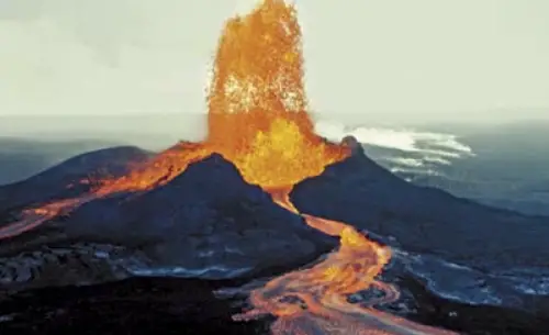
Comparing the webcam to yesterday, the flow closest to the cone is definitely brighter now. There is also a small break out at the bottom right, going left, which wasn’t there yesterday.
If this continues for another week, you would expect a lava tube to develop. That would be good news in the sense that the lava would be channeled to Kapoho where there is not much left to damage. Actually, some 30 houses seem to have survived so far, set away from the coast against the 1960 flow. If the flow stays as is, they might survive but it is precarious.
Regarding whether the 600 homes were houses: Hawai’i news has been careful to separate ‘homes’ from ‘structures’. I counted houses on google image and thought there were about 250 houses in Kapoho butt hat image was some years ago. The news said 500 houses in Kapoho which is not impossible.
Hawaiian culture is very different isn’t it. Hula, flower garlands, butt hats…
Took me a while to spot that!
🙂 I was a bit worried about that. I thought readers might just be divided into two groups: ‘Crikey, this bloke’s mental’ and ‘Alexa, order 1 Hawaiian butt hat.’
Come on, give it a try..
After you spotted it, I couldn’t really go back and fix it! From now on it will be a must-have fashion accessory. Lava proof.
At the flow rate this has (70 to 100 m3/s), the same amount of lava flows through that channel in one day as was erupted from pu’u o’o in two weeks, the only other eruption on kilauea with a higher average flow rate for this long was the 1840 eruption. Tubes might form in slow overflows but not on a raging river of lava like that. In fact the channel near the vent seems to have no crust on it at all, it is just a glowing orange flow for about 200 meters.
The overflows near the webcam might form small tubes, but the only bit that major tubes might form in is where kapoho was, because it is really flat and lava might not organise into one channel there. Above that it is open channels all the way down to halekamahina cone. Once the flow front is some distance from the channels it seems like the lava level drops slightly and that part becomes stable, so unless the output increases significantly I dont think any channel overflows will happen along most of the flow.
http://www.bigislandvideonews.com/2018/06/08/video-5-pm-eruption-update-usgs-conference-call/
This has an overview of the entire flow in one continuous video, it also shows the fountain is maybe a bit higher, although the video in my original comment was after this one so I’m not sure what it looks like now.
A detail from a HVO image this morning. This is overlook parking lot, since this morning known as ‘the former overlook parking lot’. This is what HVO called it and you can see why.
Once the lava lake returns, this sign may come in useful on Crater Rim Drive
Perhaps they are two under one roof houses?
Not in that area, I think. House density was highest in Vacation land but even there I think they were detached. But houses with dark green or just dark roofs may have been difficult to spot.
Kilauea seismographs getting very noisy again. Fasten seat belts.
14:48 5.2
I’m visiting the Big Island this week. Is there a place I can go to take great pictures of the fountaining that will not get in the way of local residents?
I would look at Google maps or earth and find a high spot away from the closed areas. The other idea would be to head south from Hilo. I think with both options, trying not to interfere with displaced home owners or the first responders that have to be there. We are looking to visit in July and will try the same thing. Would love to have the children witness this but we also are warning them that we might not be able to get close enough. From, what I understand it is hard to find lodging in Hilo proper due to all of the responders that have come to help and are using most of the rooms in the area.
Mac
This is what the summit looks like now, not much changed from the last picture but it does appear that it is deeper than it looked before, probably because of the angle.

I drew over it to get a rough idea of what it looks like without the steam in the way.

Based on how the previous big collapses have gone, the eruptive activity will most likely be summit dominated for the immediate future. because most of the caldera is filled it is possible for eruptions to happen outside the caldera in the upper rifts but I think the lower rift zone will be left alone for a while longer. The initial activity will probably fill the new summit crater, it might take a while now though because it has a much bigger volume than before this event, probably close to 1 km3, so it would take about 5 years of continuous eruptions to fill, which is assuming it will be continuous. Eruptions might happen on the upper part of the southwest rift as well as towards and inside kilauea iki too, and possibly near the 1974 summit vents, but the east rift is probably not going to be the center of activity for quite a while. This would be very similar to the time between 1790 and 1924, when eruptions happened really only in these areas with the exception of two distal eruptions in 1823 and 1840. The period before 1790 is marked by frequent east rift activity and ends with a large eruption in the same area as the one happening now, so there is a similar precedent.
It is really incredible how dynamic kilauea is even on a human timescale. On the 300th anniversary of the 1790 eruption, the first historical eruption, kilauea will probably look completely different to what it does now. I will likely still be alive then so I and many others will get to see it all happen first hand.
Me too. I’ll only be 137.
Well, if the singularity hits before then, you might be around to see it.
With Kurzweil’s line of thinking, the “machine superintelligence” will be derived from humans and will in effect, be us.
Yeah, I know it has a sort of Borg connotation. That’s the spooky part.
Rumination: The big issue with that “being us” idea, is that with sufficient advancements it might be possible to replicate a human consciousness in software. But what of the entity being replicated? If you make a copy of someones “self,” in theory they can not die as long as the circuits supporting it are operating and have power. But a copy is a copy. The original person will still exist, and subject to all the emotions and stimuli that they had all of their life. That person will still have a living breathing body and subject to the normal ailments that plague anyone. Once that consciousness is copied, the original person does not go away. This is the unaddressed horror of StarTreks “transporter” gimmick. Every time someone “beams” to another location, it’s a copy of the person, not the original. Each transport scene would by necessity, kill the person on the pad that is being copied. As they show the person being “dematerialized” what they are actually showing is someone being torn to shreds down to the atomic level. Yeah, they may mentally “appear” at the new location in their freshly constructed body copy, but they won’t experience the full horror of their body being vaporized at the sending station.
BTW, the original manga of Ghost in the Shell is centered around the protagonist, a fully cyborgized human, dealing with whether she is real or just a machine. This was only partly addressed in the Ghost in the Shell movie. (and despite the critics lamenting that Scarlett Johansson was an inaccurate choice for the role of Motoko, that is the way the manga was drawn to begin with.)
If we carry on as we are it WILL happen. Dunno about the ethics but not my problem.
More importantly why hasn’t it happened millions of years ago in our galaxy?
“A technology adequately superiour to ours will appear to be magic”.
Hey Turtle where did you get that summit image from and when was it taken ?
https://volcanoes.usgs.gov/volcanoes/kilauea/multimedia_chronology.html
The crater rim drive (now closed) passed into the caldera in the southern part. There wasn’t a steep gradient there, it smoothly went down into the crater. Perhaps this is not the first collapse in that part of the caldera?
https://www.youtube.com/watch?v=Z1Nl3XFjgw0
In 0:21 there is an incredible view of the massive columnar laze plume with some interesting convective patterns visible in the surface of the ocean with lines of steam converging at the base of the plumes and resembling the typical cell structure.
I think we need to start a pool on when GPS NPIT stops transmitting. I think that anyone that works at the USGS, HVO need to abstain from guessing.
If it has not already quit?
Still going as of last update.
I think it is on a part that is falling quite slowly, the closer orange area on my picture above. It has fallen 10 meters or more, which is much too high to be explained by deflation alone, but the crater is well over 1 km wide so 10 meters will look quite small so it isn’t that obvious in the pictures. It is quite possible for it to survive just fine actually, as the outer cracks won’t necessarily become part of the crater, the caldera as a whole extends much further out than the visible depression but those faults didn’t become the new rim. The overlook crater will probably not change too much now that the deflation is slowing down, it will make for some very photogenic eruptions if vents break out higher up and flow down the steps to the bottom.
I dont see the defaltion slowing down at the GPS. The only one that is doing that is UWEV the other four summit GPS show the same rate or slight acceleration.
And today was a demonstration of the major benefits of using drones for surveying the lava. The deputies in the area were notified that the drone operators would be in the area recovering a downed drone. Has that been a manned aircraft, a tragic event would be underway.
this is an interesting video,, with the topography of the island of Hawaii with bubbles in circular motion down from the Puna ridge, maybe their has been an underwater entry from the current eruption, would make sense in a way, I am not an expert, just thinking
These vents are their own volcanoes and not directly linked to kiluea. If they are volcanic at all. So it would be a pretty big coincidence if one were to erupt. Nor do we see any pumice rafts or other volcanic polution.
I think its just a weird watercurrent or something.
That is very close to the shore so I think is related to the lava delta and also this upwelling bubbles of hot water will acumulate in one of the sides of the entry because of the surface currents of the ocean and the average for Hawaii and particularly for Big Island is for them to flow westward so it makes sense to me the bubbles to be where they were.
The video is taking 10 minutes for something that could have been said in 30 seconds. It is also utterly unconvincing. The ‘plume’ (just a patch of calm water) is not much more than about 100 meters from the lava front, I think, not the quarter mile he claims. It could be anything or nothing. A minor collapse along the lava front could have put some lava further out. But it could just as well be some oil from a ruptured fuel tank in Kapoho. Sure, there may have been under water eruptions in the distant past. But not now: the lack of earthquakes much beyond Leilani tells you where the rift ended.
Not to mention that unless the magma release is beyond about 2.3km deep, it’s gonna be unmistakable as to what it is. No conjecture needed.
HVO has more information:
“Observers also noted vigorous convection taking place up to 0.9 miles offshore from the entry points.”
That suggests under water lava flows. Effectively, lava tubes.
Here’s a higher resolution plot of the summit deflation. You can see the big summit explosions in the higher time resolution
Any reliable update on Fuego?
A mile of new land near Kapoho Bay? No, a mile of new land ON Kapoho bay. (Kapoho bay was already partially filled with magma from previous flows so there wasn’t that much additional mass that was needed to fill it the rest of the way.)
As for the freezing rain thing… pyrocumulus clouds follow their own dynamic that is a bit outside what normal cumulus clouds do. Normal cumulus are driven by the heat content from the warm moist oceanic air (Ocean surface ≈25°C). Pyrocumulus have a higher thermal energy driving their formation (From magma ≈1000°C), so they can in theory, reach a much greater altitude. The higher the altitude, the cooler the air until you reach the tropopause. (at that point, temperature rises with increased elevation) Note: This change in temperature trend with altitude is why really tall and energetic thunderstorms top-out right below the tropopause. In effect, the pyrocumulus clouds are pipe-lining moisture right up into freezing air. And since their presence is outside the driving mechanisms for normal weather, you get what the video is discussing. Freezing rain in odd places… and out of season. For Hawaii right now… the prevailing temperature at about 250 mb (just below the tropopause) is about -45°C. (In general, the tropopause is assumed to be at about 200mb, but it is actually where that temperature trend inversion occurs.)
This is from the National Weather Service twitter: Fire, and ice? While Kiluea continues to erupt, obs from the Island’s other two major volcanoes, Mauna Kea and Mauna Loa tell a different story. Sub-freezing temps at the summits are leading to freezing rain and fog. In June. In Hawaii. It says is unusual but it doesnt seem to be correlated to the eruption.