
Mount Adatara (wikipedia)
Today is the 10 year anniversary of the Tohoku earthquake. The M9 off the coast at Sendai, Japan, was impressive enough by itself, but the main impact came from the huge tsunami that followed. I remember it well. My lecture the previous day had been on the physics of tidal waves and tsunamis. I had the same group of students again that morning. Immediately before that lecture I saw the first videos of the disaster in Japan which had happened only a few hours before. It was a very sobering lecture that day, with the excitement about the physics of waves the previous day in sharp contrast to the real-life events from those waves. One of the videos of the disaster especially remains in my memory. It shows people looking on from a long distance, first in excited chatter about the wave, then rising consternation as the destruction becomes clear and finally fleeing in blind panic as the final flow of the tsunami reaches them.
Nowadays we seem to remember Fukushima more than we do Tohoku. The combination of the earthquake and the tsunami caused the biggest nuclear disaster since Chernobyl. The immediate cause of the nuclear failure was the fact that the complex had been build too low above the flood line. The elevation was originally based on the highest tsunami they had ever seen in the area, over a century of observations. The buildings were 11 meters above sea level. The pumps that operated the coolants in the Fukushima nuclear reactors were placed much lower. For obvious reasons, they were meant to be within reach of sea water. Later they were raised. The reactors survived the earthquake, even though they were subject to ground accelerations that exceeded the design requirement. They turned off, as was foreseen. The pumps had their own diesel generators to make sure they would operate even when the nuclear power was off. Nuclear reactors overheat without the pumps that move the coolant – even when the reactors are off. The tsunami here reached 14 meters, well above the worst case scenario. It flooded the pumps and even the lower floors of four of the six reactor buildings. The diesel generators were located on these floors: all four generators failed. Now both the reactors and the pumps were off-line for four of the six reactors. That had not been foreseen. The rest could not be prevented.
Ten years later, much of the area still remains prohibited and the local population evacuated. It shows that when safeguarding nuclear reactors, the risk analysis should be overcautious. It had been unwise to base the design on only one century of data. In addition, the risk analysis should also have considered unexpected combinations of events. Of course, an earthquake of M9 is far from a common occurrence. But the consequences of failure are too severe to skimp on the emergency plan.
This was ten years ago. There will always be earthquakes here. There was an M7.3 just last month. But these are not at the level of Tohoku. However, earthquakes are not the only problem affecting the region of Fukushima. It also has volcanoes. Troublesome volcanoes.
The region

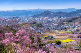
Fukushima is a province (or Prefecture) of Japan. It is rather more than the exclusion zone on the coast. ( The infamous Fukushima reactor is approximately where the ‘6’ is on the map.) The cities are mainly in-land, in a basin within a mountainous region. The capital city is also called Fukushima. The area is known for its food: fruit from its orchards, Kinsuisho sake, and a wooden lunchbox called wappa. It has the 4th largest lake in the country. And it has eye-watering mountains.
The eye-watering nature is because these mountains are volcanic, and emit sulfur. There are two main volcanoes here, Bandai is the tallest and best known. At one time it was compared to Mount Fuji. Nearby Adatara is slightly lower and far less famous. Let’s look.
Adatara volcano
Adatara consists of several overlapping stratovolcanoes, with different ages. (Japan is a crowded island and even volcanoes have to live with limited personal space.) (This area is not densely populated by Japanese standards, though.) There are two main peaks, Tetsuzan (1709 m) and Adatarayama (1699 m). In between the two lies Numanodaira crater, about 1.2 km diameter and 300 meters deep. The crater is old : it formed during a plinian eruption 120,000 years ago.
The three cones form a north-south oriented chain. There has been a volcano here for 250,000 years. This is an old system, a survivor. There were three main phases in its development. The oldest eruptions were on the eastern side, and happened between 250 and 200 thousand years ago. A quiet interlude followed which lasted 80,000 years. It ended when 120 thousand years ago the summit area erupted in a fairly short-lived phase of activity. This was the time of the major eruption that formed the crater. By 100,000 years ago the activity had shifted to Numanodairo: since that time, all eruptions have come from around this crater. The crater still contains sulfuric fumaroles, hot springs, and some hot mud pools. The river that begins here and flow to the west is called ‘Iogawa river’, meaning Sulfur river; in its upper reaches it has a pH of 2-3. (Further downstream it is known as Sukawa river.) The magma composition has changed over time. The oldest magma was andesitic. Later, tholeiitic magma was added. The two magma sources were active simultaneous, as two separate magme chambers. Eventually the andesitic magma became exhausted, and now the felsic (tholeiitic) magma dominates.
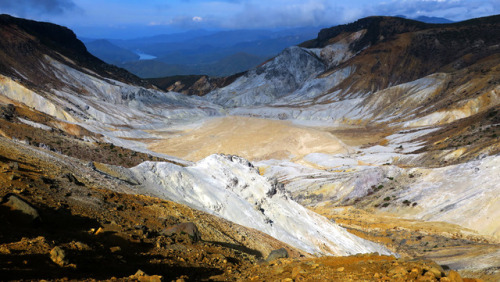
Numanodairo crater
The last documented eruption was in 1996. On the world scale of volcanic eruptions, this may well hold the record for the smallest reported event, ever. An explosion spread mud about 100 meters distance. A similar explosion happened in February 1950 with the plume reaching a massive 50 meters (that is meters, not kilometers). It doesn’t sound too frightening.
However, don’t let these micro-eruptions fool you. This is a deadly volcano, not a tourist attraction. Think White Island and you’ll get the idea. There are popular hiking trails on the forested slopes of Adatara. But you should not go into the crater. In 1997 a group of 14 hikers became disoriented in fog, lost the hiking trail and ended up on the floor of Numanodaira crater. At other times that would not have caused major problems. Not so this time. The fumarole gas had not dispersed as usual, but had collected on the floor of the crater because of very light winds. The air at the bottom had turned toxic: four of the hikers died from exposure to a lethal dose of H2S and CO2.
And this mountain had done much worse in the past. There was a more significant eruption in 1900, on July 17. At that time there was a sulfur mine within the crater. (It sounds so much like White Island.) At 4 pm on that day a small explosion occurred. The workers at first stayed where they were. There had been similar mud explosions in the previous year, so they were used to a bit of muddy excitement. Only when a second explosion came at 6 pm did they begin to evacuate. They took the western road. When reaching the rim of the crater, a third explosion came, on the opposite side of the crater. This was large enough to generate a small surge with some damage around the mining settlement. At 6:30 pm a much larger explosion came. It destroyed the mine and the houses. Ash fell, and a pyroclastic surge formed, in the direction of the western evacuation route. The workers were overtaken by the surge. 22 of them died and the others had serious burns. the total number of casulaties (dead and wounded) is reported as 72. A lahar came down the river and affected a village about 2 km away where some houses were destroyed. Even a volcano with micro-eruptions deserves caution.
Bandai volcano
Mount Bandai
This unpredictability is shared with its neighbour, Bandai volcano. It is about equally tall. Bandai used to be a well-shaped volcano, known as the Fuji of the north. (Apparently, anything north of Tokyo is known as ‘the north’ in Japan.) It wasn’t quite as regular as Fuji: there were four peaks around the summit region. It changed 1888. There had been some earthquakes at the mountain in the previous weeks. But Fukushima knows all about earthquakes and these did not seem concerning. At 7am in the morning of 15 July, the earthquakes became strong and frequent. At 7:30am, there was a big explosion: Bandai had erupted, out of nowhere. An eye-witness (a survivor) said that the ash column came from Ko-Bendai, the second highest of the four peaks.
‘Showers of large and small stones were falling all around us. To these horrors were added thundering sounds ..’ The eye-witness fled, but almost immediately fell from a strong earthquake. ‘It was pitch-dark; the earth has heaving beneath us; our mouths noses and eyes were stuffed with mud and ashes’. When he escaped an hour later, he was the only one remaining of his group.
This had only been the first explosion. The strong quake which brought him down was probably the first landslide which was triggered by the eruption. But around 9am, the peak of Ko-Bendai ceased to exist. It collapsed in its entirety, not with an explosion but with a slide. More than a cubic kilometer of rock came down the north face of the mountain, reaching as far as 15 kilometers. Several villages disappeared. The death toll is reported as 477. The rock slide dammed the rivers in the region, and water levels began to rise. Where once was the town of Hibara, now is lake Hibara with the town submerged below it. Other lakes formed, large and small.
Since 1888, Mount Bandai no longer looks like Fuji. From the north, the central part of the mountain is missing. The new lakes are still there, in a landscape covered with hummocks left by the debris flows. New villages have grown. And Bandai is still there. Waiting.
Patterns
Adatara is not seen as highly dangerous. Its recent activity and eruptions present a danger only to people who venture too close. Bandai is different. It has a much more violent recent past. But one thing we have learned from Fukushima is not to base your risk analysis on the recent past. The reactor was build to withstand the biggest event in recent years. But in the more distant past, much larger events had taken place and those had not been considered. The 2011 Tohoku earthquake was extreme but not exceptional. Go back millennia, and this had all happened before, and it will happen again. With that in mind, what is the real danger of these two volcanoes? It turns out, a very unexpected one.

Source: Kyoko Kataoka and Yoshitaka Nagahashi, 2019, Sedimentology, 66, 2784-2827
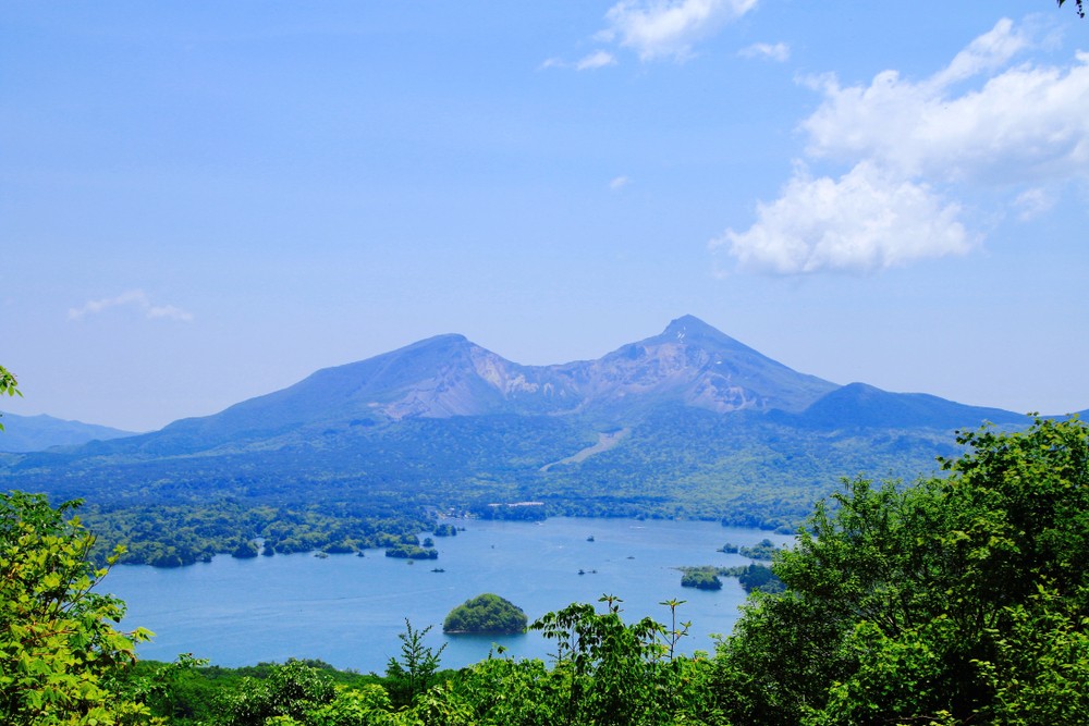
But first the expected ones. Lake Inawashiro-ko has already been mentioned as one of the attractions of the region of Fukushima: it is that 4th largest lake of Japan, 55 kilometers long. It wasn’t always here, and it arose from volcanic activity. 50,000 years ago, Mount Bandai erupted. It was a large plinian eruption, but the main effect came from a flank collapse like 1888. This was a large collapse, with 4 km3 of mountain coming down the slopes (four times more than in 1888). The slide went south rather than north. The debris flow and the pyroclastics dammed the local valley, and this is the origin of the lake. It was caused by that innocently looking volcano on its northern shore. Much of the water it has still comes from Bandai and Adatara, via the Nagasegawa River. It was a notably acid lake, probably casued by Adatara’s sulfur (Bandai lacks sulfuric fumaroles.). Nowadays, agricultural run-off and pollution have brought the pH of the lake to near neutral.
Inawashiro-ko (Japan National Tourism Organization)
So Mount Bandai has done these St-Helens-like collapse-eruptions before. This is an inherently unstable mountain. There have in fact been 8 major debris avalanches over the past 100,000 years. It also has effusive eruptions which slowly rebuild the mountain, ready for the next collapse.
Adatara is also explosively eruptive, and shows evidence for sub-plinian and plinian eruptions (VEI 3-4), once every 1000 to 20,000 years. There is no recent evidence for lava flows: the youngest dated one was 70,000 years ago. The VEI-5 eruption which formed the crater was a one-off event, 120,000 years ago. Smaller, vulcanian eruptions (VEI 2-3) have left 5 tephra layers dated to the last 10,000 years. Adatara does not show evidence of any flank collapses. But the Sukawa rivers does show lahar deposits from Adatara: 17 lahar layers are known from the last 14,000 years.
Lake Inawashiro-ko contains a 50,000 year record of eruptions from both volcanoes. Tephra falls form thin layers at a variety of depths in the sediment at the bottom of the lake. Other layers are caused by lahars from both volcanoes which reached the lake. The two volcanoes can be distinguished by chemistry: ejecta from Adatara has a higher potassium content. That may be related to differences in the basement: Bandai volcano grew on the thick Shirakawa ignimbrite, perhaps 10 million years old (Pleistocene) and 60 km3 in volume (DRE). The lahars were mostly triggered by phreatic eruptions, but a lahar layer dated to the spring of 497 BC is suggestive of having been caused by snow melt. There are also multiple debris layers which are attributed to small flank collapse events at the southern slope of Bandai, the scar region of its largest collapse 50,000 years ago.
The many layers indicate that Adatara was frequently active between 50 and 29 thousand years ago and decreased after that, while Bandai remained at a high level of activity for 5000 years longer but after that also declined. The decline in activity may not have been volcanic: the growing delta meant that lahars and debris flow had to travel further to reach the lake. In the past 10 thousand years, Bandai has left the lake largely alone but phreatic eruptions at Adatara have deposited 10 cm in various (at least 5 major) events. Note that Bandai may have erupted and collapsed in other directions, avoiding the lake. (The 1888 eruption was large enough that it does show in the lake even though the collapse went the other way.) Each volcano erupted into the lake some 30 times over the 50,000 years that the lake has existed.
The layers of the lake have shown that the frequency of eruptions from Adatara is three times higher than had been recognized before. Its tephra-producing eruptions have a mean recurrence time of 640 years. For Bandai, the eruption rate is about 50% higher than thought, and 1888-type eruptions may occur every 2000 years. This count may still miss eruptions, since there are some eruptions known that left no trace in the lake.
Such activity levels should not be ignored in the local risk analysis. For Adatara, the risk is mainly local as its phreatic eruptions are not large, but it does do vulcanian and sub-plinian eruptions which cloud reach the local hiking trails and ski regions. However, lahars are a danger. Bandai is inherently dangerous and should be monitored.
And notably, the town of Inawashiro with 14,000 people is located within the reach of the lahars from these volcanoes.
So far the known dangers. But recently, an unrecognized danger was found.
The 2021 Fukushima earthquake
In February this year, the Fukushima region was affected by an M7.3 earthquake. The focal point was 70 km off the coast, and it may have been an aftershock of the 2011 earthquake. There was quite a bit of damage in the area, with cracked walls, broken water pipes, and some landslides. There were 180 injuries and 1 fatality.
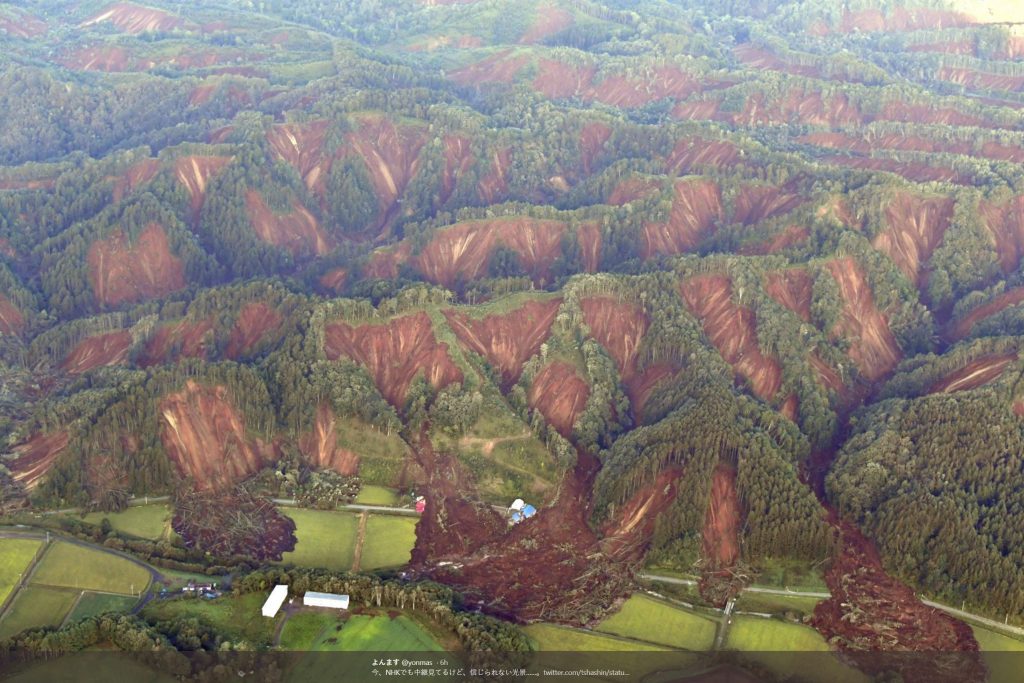
The most significant damage affected the famous motor racing circuit of Ebisu, 50 km east of Adatara. It is famous especially under afficionadas of drift racing, and has multiple separate circuits built into the side of the mountains. There were some cracks in the asphalt caused by the quake. But much worse was a major landslide which took out some cars, a two-story building and several of the tracks. The site had been deserted at the time, and no one was hurt. But Ebisu will be closed for the foreseeable future, or at least until funds have been raised for repairs.

Investigations into this landslide showed that the cause was not any local building work. Landslides are often caused by building activities (such as roads) which destablize a steep slope. The first suspicion was that something similar happened here. But instead, the slope itself was to blame.
It turned out that the slope consists of soil which rests on wind-blown tephra layers from Adatara. The tephra layer is 10 meters deep and dates from Adatara’s entire quarter of a million year history. This again rests on a much older debris layer of similar thickness, and below that is the even older ignimbrite. The cause of the slope failure was hiding in the Adatara tephra. The shaking destabilized the loose layer, and this started the landslide.
Volcanic soils on steep slopes carry a risk of landslides. This is in particular during earthquakes. The 2011 Tohoku earthquake had caused three similar landslides in this region, traced to the same wind-blown tephra. And it happens elsewhere in Japan too. The M6.6 earthquake in Hoikkaido in northern Japan, September 2018, caused a large series of slope failures on steep slopes. These happened in pyroclastic fall deposits from Tarumae, Eniwa and Shikotsu Caldera in western Hokkaido, dating from 9000 to 47000 years ago.
Slope failures from the 2018 Hoikkado earthquake
Volcanoes are dangerous, but we understand those dangers and can be prepared. Earthquakes are dangerous, but again we can be prepared. Both are manageable events. The Fukushima nuclear reactor ran into trouble when two manageable events combined, in a way that the emergency plan had overlooked. So it is here. There are unexpected dangers in the combination of earthquakes and volcanoes. Even when those volcanoes have long been inactive. Beware of volcanic soil.
Albert, March 2021
https://unseenjapan.com/mount-bandai-japan-eruption-volcano/
https://onlinelibrary.wiley.com/doi/full/10.1111/sed.12629/
https://blogs.agu.org/landslideblog/2021/03/09/ebisu-circuit/


Maybe imagination but, looks like some steam is coming out of dark crack like feature close to the upper left corner of the mudd?square
I think it’s more like low light levels causing the image to pixelate. You can see it all over the image to varying degrees.
Mind you, I’ve been wondering what that gingered headed fella with the shades is up to at the bottom of the screen. Probably a bit stagestruck by the camera 🙂
Strombolian activity started in Etna-dyngja south east crater… probably we will have another paroxism tonight.
Nice! I love it when they happen at night-time, a brilliant column in the darkness.
Not this time, unfortunately.
Boris Behncke@etnaboris. 6 Min.
In the evening of 14 March 2021, we saw the first signs of a new paroxysmal eruptive episode at #Etna’s Southeast Crater. Then clouds moved in and veiled the volcano. Paroxysm # 13 in a month will take place behind dense clouds.
Going back to 2014 the end of this clip may give some idea of what we may see initially here if there is an eruption. There probably wont be so much smoke and steam as there is not a lot of ice around to melt…But what we may see is firstly a small orange bright flaming area that rapidly spreads. However every eruption is different but watching this clip may rule out other more stable lights. But if you do see something shout about it…….it gives us all something to look whilst we are waiting. I get the feeling if this erupts we will be sure it’s an eruption from the word GO. (I’m only a cock-eyed optimist ♫ ♫ ) https://www.youtube.com/watch?v=7kflml7Rbj4
Beautiful! i hadn’t seen that one.
That youtube channel is runned by an absolute freak😂 just his name is … very non – science based … hysteria and conspiracy
Thats Dutchsinse..s channel! 😂
Lol Jasper……….. I used this purely as an illustration what we may see initially on cam if there is an eruption. I am not belonging to the doom and damnation brigade. I am a rather elderly biologist with accurate scientific education firmly my priority.However also as a scientist I always have an open mind until facts are proven and even then my mind is a little ajar.. I always remember being told by my teacher that mountains were formed because the earth,like a baked apple, is cooling and so it is going all wrinkly forming valleys and mountains! I wondered then why Everest isn’t getting higher! I think that was the start of my fascination for geology!
Jesper’s right. That youtube account should just be ignored. What we see in that video is not the opening of a new fissure, but steam rising as the advancing lava field boils away the water from Jökulsá á Fjöllum. The eruption had already been going on for a month when that video was recorded.
hi guys…there is smth light on this camera…is this normal? upper right ….
https://www.ruv.is/frett/2021/03/11/beint-vefstreymi-af-skjalftasvaedinu-borgarfjall?fbclid=IwAR2FQN8FrKMUvtlfuVUinKwxMl4MDlLD5H_KYjZtZo8fLcIWd9j0T8Dfp7Y
If you get a bit bored, go here and look towards Keilir. See if you spot Felix the Cat:
https://firms2.modaps.eosdis.nasa.gov/map/#t:adv;d:2021-03-14;l:noaa20-viirs,viirs,modis_a,modis_t,nrt_noaa20-viirs,nrt_viirs;@-22.2,63.9,13z
Black as The Night, is the Keilir cam. However, the Keilir-thermal camera shows dark clouds moving. It must be clouds, right?
https://www.livefromiceland.is/
A fog bank or just a huge evil creature. Nothing to worry.
Can you see the bright smile made by the green stars right now? 😉
Rock fall today caught on camera. https://www.youtube.com/watch?v=q_evPvNczow&t=68s
That was scary. A few hundred meters closer to the mountain and things could have turned out really bad. The persons involved were warned that something like this could happen. A warning about possible rock fall is on the IMO website.
A new article is up about the uncertainty phase in Iceland!
https://www.volcanocafe.org/the-happy-dyke-of-fagradalsfjall/
“My lecture the previous day had been on the physics of tidal waves and tsunamis.”
This reminds me of an experience I had back in 2004. I was in fourth grade and our teacher was reading a book to us about Japanese tsunamis. If memory serves me right, it was right before Christmas break and I don’t believe we ever finished the book. I guess the teacher thought it would be awkward to continue reading such a book after the catastrophe.