
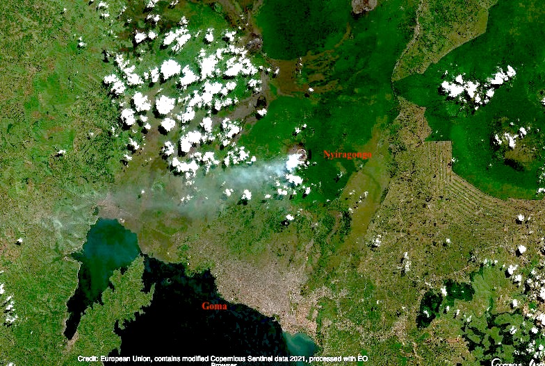
Few people would have heard of Mount Nyiragongo before its current eruption. There are some cities that we know live in the shadow of a volcano. Naples and Vesuvius, Catania and Etna, Seattle and Rainier (although the city itself is unlikely be affected by an eruption), Fuji and Tokyo (with the same proviso). But Nyiragongo is worse than any of these. It erupts often (the current eruption is number 35 since 1882). The effusive lava is very fluid and moves fast. Worse, the mountain is extremely steep for this type of eruptions, reaching 50 degrees near the summit. The lava flow can reach speeds approaching 100 km/h. And the city of Goma, with half a million people, lies directly in one of the paths the flows can take. Finally, this is in the DRC, perhaps the country worst equipped to deal with volcanic risks. Both the 1977 and 2002 flank eruptions had a significant number of fatalities in Goma. In 2002, 13% of the city was covered by 2-meter thick lava as it flowed towards Lake Kivu. And fatalities continued long after the eruption had ended.
Since 1970, there have been 25 volcanic eruptions worldwide with fatalities. By far the worst was Nevado del Ruiz, where 23,000 people died. Second is El Chichon, followed by Pinatubo, Anak Krakatau and Merapi. (In my opinion, Kazbek should be added to the list.) Nyiragonga was already the only volcano to appear in this list twice, with both appearances among the 10 worst eruptions of the past 50 years. And now it is in this list 3 times.
(The number of eruptions worldwide with fatalities has increased dramatically in recent years. Since 2010, there has been on average one such event per year. Before that it was much less. In two cases tourism was involved, but the others were people living in the wrong place. With volcanoes, precaution is the only effective strategy.)

People crossing the hot lava on foot, the day after the 2002 eruption. Many burn wounds resulted. Heavy rain a few weeks later caused dense fog and gas, which led to further fatalities. Luckily the 2021 eruption was in the dry season
We often discuss the dangers of explosive eruptions, and point at Krakatau, Tambora or El Chicohn. Those kinds of eruptions are huge, devastating, and unpredictable. Often the culprit was not recognized as dangerous prior to the explosion. Effusive eruptions are more sedate, tourist-friendly, and predictable but also more frequent. We acknowledge the damage they can still do, and the desperation of people seeing their home engulfed by lava. There is no such thing as a friendly volcano. But Goma finds itself in the worst of both worlds. Its mountain suffers frequent effusive eruptions which come fast and without warning, and are as deadly as explosive eruptions would be. And it is not only the lava. The gas emissions cause acid rain which can damage plant and tree growth on the mountain. Near the crater rim, underneath the volcanic plume, the rain can have pH as low as 2. Low pH and high fluoride has been measured as far as the village of Rusayo, 10 km from the summit.
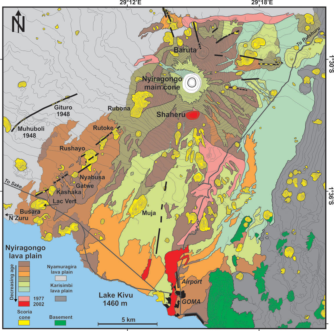
Geologically, Nyiragongo is part of a cluster of volcanoes, two of which remain active. Together they form the Virunga bulge, home of wonders including the impenetrable forest and its mountain gorillas. The bulge sits at the intersection of the Albertine rift (the western branch of the African rift, running north-south – the volcano, as well as Goma and Lake Kiva are located in the rift), and the Kamatemba rift (running northwest to southeast into the Albertine rift). Exactly what feeds the volcanoes is being studied, but a crossing of two rift indicates this is a weak spot. Two magma chambers are suspected, one shallow and one 14 km deep.
The unusual lava of Nyiragongo is attributed to a melting of a carbonated mantle. It differs from all other lavas in Virunga. This seems related to the depth: its magma formed from a much deeper melt than elsewhere in the Virungas. The lava is often claimed to have the lowest viscosity of any volcano known but this is disputed. It is fluid, but the extreme speed of the lava is caused mainly by the steepness of the cone.
The steep cone is not what one would expect from low viscosity lava. It should have build a very broad shield, not a cone. The mountain cannot have been build by these lava flows. There are several possibilities. There may have been a very recent change in the magma. But none of the lavas seen in this area can build such a steep cone. The second possibility is that the mountain was not build from the outside but from the inside. The mountain is in effect the sides of the conduit. Magma rises, forms a lava lake, and the lava lake solidifies against the sides and adds bulk to the mountain. The magma builds the mountain around it. Because this builds the mountain with solidified rather than liquid rock, it can be much steeper than flowing lava would allow. The lava lake has several benches: these benches are how the mountain grows.
The 1.2-km wide, deep crater of Nyiragongo hosts the largest lava lake in the world, some 200 meters wide. The mountain is 3470 meters tall; the lava lake is typically at a height of 2700-3000 meters, while Lake Kivu is at 1470 meters. You can imagine the stress that the sides of the mountain are under! It carries a 1-km wide bucket of lava at the narrow tip of a steep cone. The sides of Nyiragongo are indeed riddled with rifts, many of which are unmapped because of the dense vegetation. These rifts can feed the eruptions, as they did in 1977 and 2002, and apparently also in 2021.

The volcano is about 12,000 years old; the current deep crater is though to have formed a few hundred years ago through caldera collapse. There have been previous collapses: there are two other but extinct craters of similar size, one located two kilometers north (Baruta: visible on the image) and one 2 kilometer south of the current crater (Shaheru). The three cratered cones are aligned: there seems to be a short north-south rift underneath Nyiragongo. This rift follows the direction of the Albertine rift and therefore may have benefited from spreading in the Albertine. In contrast, the Virunga volcanoes overall follow an east-west line. Although the parasitic cones are themselves extinct, they are not immune. During the 1977 eruption, lava erupted inside Shaheru crater.

The flows and source of the 2021 eruption. Click on the image for full resolution. Sentinel image from June 2020
The 1977 eruption formed a rift just above the Shaheru crater; lava flowed into this crater. The 2002 eruption showed lava fountaining above Shaheru from the same fracture. But the 2002 eruption extended this rift much further. The southern flank of Shaheru was ruptured in two places, 300 meters apart. The rift extended downward towards Goma, causing small grabens with lava fountains in several place along the way. These fissures reached the city itself.
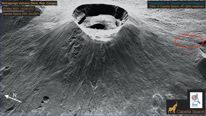
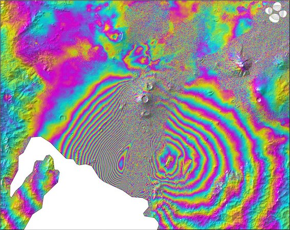
Capella radar image of Nyiragongo (https://twitter.com/RaphaelGrandin/status/1396948118067888128). The rift that was active in the 1977 and 2002 eruptions is indicated by the oval.
The 2021 eruption appeared to have started just southeast of the Shaheru crater, close to previous flows. The lava appear to have come through the same fissure as in 1977. The flow split in two, with the longest one heading south, ending within the Goma suburbs close to the airport runway. In the day after the eruption, Goma was hit by several earthquakes which caused cracks in roads. This seems to have extended the activity of 2002, when minor rifting and gas emission was seen 500 meters beyond the lava flows, as far as the airport. In 2021 it reached just off-shore into Lake Kivu. A long crack in the N2 road parallel to the coast also suggests some ground movement within the lake. The rift has thus progressed from 1997 when it formed as 2-kilometer long fracture, to 2002 when it extended by 15 kilometer, to 2021 when it added a further kilometer. Note that this does not mean it is exactly the same crack. Rifts have a certain width and the new crack may be next to and parallel to the previous one.
The eruptions are fed not from a magma chamber but from the existing lava lake. This means there is little or no tremor preceding the eruption as there is no rising magma. Instead, they start when the growing pressure of the lava lake breaks through the steep sides of the cone (a fate the Geldingadalir walls are trying to avoid), involving tectonic earthquakes. In 2002, the eruption was preceded by an M4 earthquake two weeks earlier. This earthquake may be when the break first began to form. The 2021 eruption did not have a clear precursor earthquake. (An earlier claim in this post for a precursor earthquake was based on an erroneous location.) The aftermath is also the same. In 2002 there was earthquake activity on a line between Goma and Nyiragongo for 5 days after the eruption, with the strongest even M5, and in 2021 there were several earthquakes in the day after the eruption also peaking at M5. This pattern adds some predictability to the Nyiragongo eruptions.
But this expanding rifting activity points to another major danger, beyond that of an eruption in the heart of the city. This mountain seems unstable. The rifts in the side are integral to the mountain (that can be seen because many of them directly feed volcanic gasses into the water system). There could be a failure where two of the side rifts combine and one side of the mountain slides down-hill. Such an event would be catastrophic. Most volcanoes in the Virungas show no evidence for a flank failure, but the extinct Mount Sabyinyo does have a big gap in its side and on satellite mages a 1-km wide crater, 2 km southeast of Mount Karimbi also seems to have a gap on the side facing away from Karimbi.
But let’s look at Goma itself. Why build a major city in a place where it has been hit by lava streams three times in the past 50 years?
Goma is at the border with Rwanda. Gisyeni, the part of Goma on the Rwandan side is well connected to the Rwandan capital, Kigali. Travel in the DRC can be more difficult. The area is very densely populated, fertile, with mild tropical climate. The Rwandan genocide in 1994 caused many refugees to flee to Goma, with rebel movements following. The area has remained rebellious and it is not always under control of the central government. People are attracted by the mineral wealth of the DRC. This should be a fabulously wealthy country. Instead, the wealth goes to however manages to profit most. Some of the rebels have a cause. Others just want the wealth for themselves. And earlier this year, the Italian ambassador (who also helped to run the world food program here) was killed by rebels, in a kidnap that went wrong.
And in spite of the insecurity, Goma has grown rapidly. The current population is estimated at 670,000, growing at 5% per year. It is now three times the size it was during the devastating 2002 eruption, and ten times that during the 1977 eruption! New roads have been build (many by Chinese contractors), on top of the 2002 lava.
In view of such unstoppable growth, where do people live? They can’t go east, towards Rwanda, as Gisenyi is too small and itself has no room to expand. West gives some space but quickly takes them out of the rift valley. South lies the lake. So the city grows west along the lake shore, and north on the plains leading to the Virunga mountains. Much of the land is already taken, and so people build houses where they find unoccupied space. People have to get to work, using the taxis, any ride they can get, or by walking. So they live near the roads. Conveniently, there is space here which is not farmed or otherwise occupied. That is, they build their houses on top of the recent lava flows.
A time line shows the growth of Goma. The image below is from 2005, when the 2002 lava flows are still visible.

Goma, 2005
The most recent image, from 2019, shows dramatic changes.
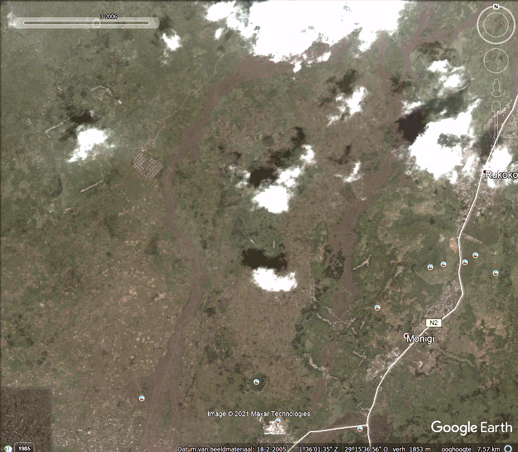
Goma, 2019. Click on the image or here to see a timeline
Putting the Google earth images together (thanks Gijs, Lughduniense!) shows the rapid expansion in a time line of Goma’s growth towards Nyiaragongo..
As you can see, the expansion of the city follows the 2002 lava flows very well, along the roads build on those flows.
But the lava flowed along those paths for a reason. Nyiragongo can erupt in all directions, but in the three major eruptions of the past 50 years the lava has gone south, following the underlying north-south weakness in the mountain. This rift formed in 1977 eruption, was re-activated in 2002 and possibly again in 2021, extending through the city and now into the lake. The rift provides a pathway for the lava which inevitably ends up in the same area as before, following very similar flow paths towards the lowest points. The people are living on a ticking time bomb.
They do so not by choice, but because they too have to live. These are not refugee camps, put wherever others can’t see their plight. They need houses to live and places to work. They are people just like us.
And now Nyiragongo has erupted again. The precursors were too weak to be seen on the few available instruments and by the few scientists. Do not expect magma signals: the lava is already in situ and all it needs is to break through the crater wall. The precursor was probably a faint tectonic signal. People knew that a new eruption was imminent. The lava lake had grown too big. But they did not know when. Suddenly the sky went red and the lava came. Eruptions of Nyiragongo only last a few hours. By the time the alarm was raised and the evacuations had started, the lava was already among the people. We do not know yet how many casualties there were. So far, 500 houses are reported buried, 23 people died from the eruption and 9 from a big traffic accident in the evacuation. The real toll will be higher and may never be known.
Proposals have been made to safeguard Goma. Dams could be build to divert the lava around the most endangered area in east Goma. The problem is that this would divert the lava towards other areas that are just as densely populated. Warning systems have been proposed, already 25 years ago. But hardware on the ground does not last long, often due to theft. Before the 2002 eruption, only 2 of 5 installed seismographs were still working. The rangers who lead the expeditions to the lava lake do report anything unusual – but it needs people to collate and analyse the reports. The 2002 eruption has been predicted in advance by the local scientists, based on reports from the rangers and the little instruments they had. There was failure of action on these warning by the authorities – who in any case do not carry much authority here. The 2021 eruption was expected but was not predicted.
What can be done? Monitoring from space is difficult because of the near-perpetual cloud cover over the peaks. Seismographs could be placed in Rwanda, not many kilometers away. But that is a different country and they cannot issue warnings for Goma. With such a volcano, an eruption warning needs to be instantaneous (in 2002 lava reached Goma within 20 minutes, and because the rifts extends into the city the eruption could in theory begin within the city limits), and should be unmissable. It can be done – even here, most people have mobile phones. Pre-eruption warnings need to be accurate, otherwise they will quickly be ignored. That requires significant scientific effort. And finally, we need predictions where lava is most likely to flow, and discourage people from living there. East Goma in particular should not be there. That may be the hardest task of all.
Goma was lucky this time. But there will be a next time. And one after that. And one day this could become the Pompeii of the tropics.
Albert, May 2021
Addendum 27 May 2021
A new INSAR image has appeared show ing spectacular changes in the rift valley. The image shows the changes between 19 and 25 May (i.e. including the eruption but not the subsequent tectonic activity). It is reproduced here (at reduced resolution), with the original taken from https://pbs.twimg.com/media/E2U9GXEWEAU55XF. The INSAR data is also available from https://sarviews-hazards.alaska.edu/Event/221?pinned=d989972a-8f8e-4337-9744-f9dbb668ef33,406295fb-403e-4604-acc9-4cd65ddeae09
Sentinel INSAR data, 19-25 May 2021
This looks very much like a dike intrusion but there are two aspects worth noticing. First, the coloured contours are best visible along the side of the rift valley. Second, the colour sequence on the left and the right of the valley are reversed (look for the order yellow-green). It is always hard to separate up/down from left/right in these plots (the satellite measures the distance from the satellite to the ground, and if it is not directly overhead it will see both). The reversal suggests that the sides of the rift valley are moving away (or towards) from each other, i.e. rifting. If they were moving up (or down) you would see the same pattern on both sides.
So there is rifting. But there is not much indication for a large dike. That would show up as inflation in the centre and that is not really seen. (Unless it is localized in the feature near the lake coast which coincides with a ridge in the landscape).
We will wait for more data. I think there is rifting between Shaheru and Goma. Whether there is lava inside the rift remains to be seen.


Nyiragongo is an unique volcano.
There is No other active volcano like this. Nyiragongos simple shape, steep slopes and super sillica undersaturated Nephelinite are something unique. Finaly after so many years an Article about Nyiragongo. Nyiragongo is for Myself a great favorite volcano .. that I first learnt about seeing the 2002 disaster on TV
I Myself think its the worlds most pretty volcano too at least in shape.
But there should be more content about Nyiragongo on VC .. yes I think ”The Science of Nyiragongo” is a good idea for Alberts next article
Its very alarming how fast Goma is growing
Its also growing towards Nyiragongo and not outward. Goma arera is now home to 2 million persons I think .. and its growing very quickly for soure..
What will Goma look like in 100 years IF it surivives?
– I Myself think its the worlds most pretty volcano too at least in shape.
I contest this because this place can also go to Fuji.
Or Klyuchevskoy. Nearly perfectly conical, and enormous.
Mt. Shasta is quite beautiful as well.
Beautiful drone picture of Klyochecskoys crater:
https://earth-chronicles.com/natural-catastrophe/new-cinder-cone-formed-on-klyuchevskoy-volcano-russia.html
And then I have a certain affection for this one too:

A castle with a majestic terrace from all sides.
Missing 3 D reconstruction from:
https://en.wikipedia.org/wiki/Teide
Another beautyful photo of Nyiragongos 2003 – 2021 lava lake. Looking at 100 s of Photos of Nyiragongos lava lake I discovered that Nyiragongo lava lakes generaly haves a very distinct look.
They have very small degassing fountains, and the lava lakes skinn is very thin but broken up into often small plates. Probaly haves to do with low fluid viscosity and perhaps mostly faster convection compared to other basaltic lava lakes.
This apparence have been the norm since Photos began streaming in from Nyiragongo in 1950 s when French Hauron Tazieff started to film Nyiragongo. The worlds only Nephelinitic lava lake. 1970 s looked just the same
Another closeup of the lava lake of Nyiragongo
Erta Ale did not look like this .. But Probaly because lava lake convection was slower there.
Nyiragongos lava lakes haves souch a distinct look .. that they can be instantly identifyed as Nyiragongo
Jesper, is the lava in the video more fluid than Nyiragongo lava? https://www.youtube.com/watch?v=qputaVyn7TE
Yes it is …. much more
But Thats also not a sillicate magma either .. Lengais Carbonatite magmas
Among sillicate volcanoes
Nyiragongo and Kilaūea have the lowest viscosity and most fluid lavas
With Nyiragongo having the lowest sillica of them all
Early Archean Komatite lava at 1700 C flowed like that or perhaps really like water .. looking like liquid metal sunlight erupting out the ground … at 1700 C and 50% sillica there is almost No polymerisation of the melt .. forming a liquid with a viscosity as low as water
Liquid iron slag at 1570 C is the closest that we gets to Komatites
Lengai is a carbonatite magmatic limestone .. carbon based
I was getting worried about Ingenuity as NASA had said nothing about completion of Flight 6 despite Perseverance taking images of it at Field C several days ago. Well, there was a serious flight anomaly. Story below.
https://mars.nasa.gov/technology/helicopter/status/305/surviving-an-in-flight-anomaly-what-happened-on-ingenuitys-sixth-flight/
Full story at link above but, in short, Ingenuity eventually re-established stable flight just before touchdown as it disregards certain conflicting information during the landing sequence. The underlying problem was a glitch that caused the timestamps from the IMU and the terrain following software to get out of synch.
Sadly Perseverance wasn’t tasked to video this flight (unless they sneaked it in as a test) so it seems we won’t get to see it.
Ingenuity did manage to take colour images where it was supposed to despite all this going on.
“This image of Mars was taken from the height of 33 feet (10 meters) by NASA’s Ingenuity Mars helicopter during its sixth flight, on May 22, 2021.”
Much higher resolution (29 MB) version at the link above.
Considering lack of motion blur, despite Ingenuity wobbling all over the place, I wonder if they can decrease the effective ISO rating and use a slightly longer exposure to cut down on the noise in the high res images.
Also I suppose rocking back and forwards is a great way to let the colour camera see to the horizon 🙂
Video from Ingenuity?
I read somewhere from one of the engineers (or may have been a podcast or video) that they were getting highly accurate information from the IMUs (Inertial Measurement Units) – much better than expected. If they have growing confidence in knowing accurate position with IMUs alone, they could perhaps solve the “glitch” by just switching off the downfacing black and white video camera for terrain following (they ran out of time/budget to implement the obstacle avoidance software anyway so they don’t lose that)
With the helicopter on IMU guidance only, the colour camera and snapdragon processor would easily be able to handle HD video. The hardware is capable of doing it and the reason they haven’t done it is because of prioritizing the downlook terrain video and processing as it was assumed that was vital especially on longer trips. Maybe it isn’t?
Still, I’m sure if I’ve thought of it so have they and there may be many reasons it is a bad idea!
The embedded navigation camera imagery of the last stage of flight in the tweet below may make you sea sick 🙂
https://twitter.com/NASAJPL/status/1398008822724120576
2021-05-27 Follow up of the Nyiragongo eruption
Current seismicity and ground deformation data continue to indicate the presence of magma under the Goma urban area with extension under Lake Kivu.
Seismicity remains high and continues to migrate southwards and surface deformation is still recorded by the GPS network. These observations are consistent with the continued propagation of magma at depth towards the south. InSAR data also show that deformation is continuing; the image acquired this morning shows the progression (see figures 5 and 6).
Comparison of satellite radar images acquired on 23, 24, 25 and 26 May indicates that the crater inside the summit of Nyiragongo continues to widen after the partial drainage of the lava lake. Ash fallout may occur as a result of the collapse of parts of the crater interior.
Data on the stability of Lake Kivu currently show no significant change.
https://georiska.africamuseum.be/en/nyiragongo_eruption/20210527
Hopes it dont erupt as a surtsey in Lake Kivu .. but at 400 meters depth
It woud form pillow and sheet flows
But the scary ammounts of CO2 is insane in that anoxic lake
Looks like the shallow lava lake conduit and chamber is being emptied .. Nyiragongo may contain 0,3 km3 of melt inside the edifice perhaps
Better link below
https://m.facebook.com/story.php?story_fbid=271998904613352&id=100185291794715
Recent photo from Goma… glowing cracks have appeared in a house .. looking like the magma intrusion coud breach the surface in any time … Goma have mostly evacuated now
A tiny Nephelinite eruption coud happen any time now ..
Goma is evacuated in case of eruption. Glowing cracks have already been spotted!
https://www.google.se/amp/s/www.news24.com/amp/news24/africa/news/mass-exodus-as-new-eruption-of-dr-congo-mount-nyiragongo-volcano-feared-20210527
: O
That glowing crack is pretty good evidence there is magma underneath. Right underneath.
I too would freak out if I saw that in my garage. As in, I am living on top of some very thin crust. Maybe 1 meter of crust.
Is that house in Goma or uphill towards the volcano? Would be useful to know where it was.
My dear Jesper,
I really appreciate reading your comments and opinions, they are most welcome.
But could you please take it down a notch when talking about lava composition and temperature? I think there were more than 20 posts about the temperature and viscosity of lava in the past days.
Thanks,
Dirk
Soure… now following this intrusion
I hopes it does not appear in Kivu Lake or middle of Goma
Do you think the glowing crack mean its going to erupt ? looks like it But I dont know
Happens to be one of my favorite volcanoes
some latest inSARs. The inflation is just at the worst place possible.
https://twitter.com/COMET_database/status/1398009870985707521?s=20
That is a nice image. Note that the pattern blue/red toward/away from the satellite is not that of inflation. Inflation would be one colour. It is much more like an earthquake where two sides are moving with respect to each other. This is a tectonic signal. This does not mean there is no magma/lava (I am not sure whether a lava lake that feeds an underground rift becomes magma again or remains lava): There may well be magma inside the rift. But I do not see direct indication for inflation, just for sideways movement. The GPS data that has been published for Goma and surrounding area also does not show inflation. Of course they may not be in the right place.
Above ground = lava.
Below ground = magma.
Does it matter which is first or last?
define ‘ground’. Is a lava tube really a magma tube?
Lava tubes dont count, magma is defined to be the point until it reaches the surface through the vent, and though often lava tubes trend directly from the vents so that the first time the lava actually enters open air is from the tube, it is known the tube was created as a result of lava flowing onto the surface beforehand. In 2017 the lava tube from Pu’u O’o flowed unobstructed into the ocean as a firehose out of the sea cliff for about 2 months without ever breakign out on land, the only time the lava ever gor exposed to the air was as it was plummeting into the ocean. This though was never considered to be a vent location, the vent was always on Pu’u O’o with the tube extending from it as a separate structure.
I guess the confusing thing is that it seems these sorts of lava lake draining eruptions are fed through shallow pathways, evidently as in a lot of cases lava is visible in cracks, both at Nyiragongo and also at Kilauea, and possibly Mauna Loa. In these cases though the lava flowed underground still, and broke the surface outside of where it was before.
It is a problems of semantics. The three cases. The Nyiragongo lava lake emptied through a hole a kilometer down, through the cone and exiting 2 kilometers away. Was it lava or magma between the lava lake and the exit hole?
The crack is a rift which extends over 10 kilometers, almost always under ground but in a few places the ground breaks open and reveals the lava a meter below. Does this means the flowing rock cycles between magma and lava, depending where the rift has broken ground?
A lava tube exists for decades. By that time, the solidified lava above has eroded and developed plant growth and soil. The lava tube has not changed. When does it change from lava to magma?
These lava lakes are also tops of convecting magma columns basicaly tops of the magma chamber exposed. A very rare phenomena.
The surface of the lake is lava, but the interior of the lava column is magma?
I don’t think anyone knows at which depth the lava becomes magma! If there is no conduit (a rootless lava lake) it should be all lava. But if there is a conduit, somewhere along the line the name must change.. The English language is not up to the complexity of volcanoes.
I guess it is the depth where degassing is a big factor, when talking about lava lakes. That would be about 1 km as SO2 and H2O exsolve in large amounts from this point on and the composition and physical characteristics of the fluid change, magma is probably a bit less fluid and denser than lava when it erupts, whic his highly vesiculated and almost foam, before it flows away degassed. Thing is technically we dont actually know for sure the Nyiragongo lava lake was that deep, same for Kilauea before 2018 although in that case it was observed to be at least 350 meters deep which lends to the idea of an open cylinder instead of a bowl with a leaky substrate.
That magma definition is only for lava lakes though, an intrusion that is 100 m deep is still magma except where it erupts. It is maybe tricky to say if lava breaks out of lava lake less than 1 km deep, like at Pu’u O’o in 2011, but it is a bit less important on a relatively smaller scale like that.
@ Albert – and therein lies the conundrum grammatically.
There’s no caveat to the below/above surface definition that I can find withaquick search; therefore in a strict sense, lava that goes below the land surface again should be called magma.
And yet, we do use the term lava tube, not magma tube. We also use lava to describe the solidified state forever more; basaltic lava flow, lava rocks, stones, dust etc.
Is there any other form of lava that heads back underground once on the surface? I can only think of a drained lava lake, and we call that magma, as it usually heads back into a magma chamber.
P.S. I’m such a curious ornery pedant…
Yes, it is quite confusing. I’m not really sure why the distinction of magma from lava exists in the first place, the answer may lie there, or not. They are the same thing except for the gas content.
Thanks Albert, the second photo in the series clearly mentions up / down motions. would that fit the interpretation above? I see you enjoyed the full resolution link.
https://mobile.twitter.com/COMET_database/status/1398009870985707521/photo/2
https://www.volcanocafe.org/the-sulawesi-earthquake/
I see some similarities between Goma and Palu. They both sit on a dangerous place. The liquified earth (horrible) reminds me of the Lava with less viscosity. That Sulawesi fault zone is sort of the Nyiragongo of Indonesia, it seems. I did not know this article by Albert. It shocked me.
Another similarity: In Palu the equipment was also stolen.
I’ve rarely seen anything as disgusting as liquifying earth. Those people must be highly traumatized.
San Andreas earthquakes can cause liquefaction. I 1989, much of the damage in San Francisco was in neighborhood with soil (often landfill) that is prone to liquefaction. Surprisingly the old wooden Victorians did really well. Rocked back and forth but mostly unharmed.
Many/most of San Francisco’s Victorians were built on stable, rocky hills by wealthier folks overlooking The Bay, while the masses (and businesses) built much lesser quality buildings downtown or nearer the shoreline where all the work was. Many of the Victorians survived the great 1906 earthquake with nothing more than some cracked plaster.
In 1989, the area known as the Marina District (mostly built on bay landfill) was where the major liquefaction occurred and not coincidentally suffered the most damage despite being over 60 miles from the epicenter. The collapse(s) of a section of the Bay Bridge and the Cypress Overpass on the east (Oakland) side of the bridge was due to construction on unstable landfill, so crappy ground can bite you in multiple ways.
from Volcano Discovery :
https://www.volcanodiscovery.com/nyiragongo/news/131235/Nyiragongo-volcano-DR-Congo-fears-of-potential-catastrophic-eruption-trigger-partial-evacuation-of-G.html
Authorities are highly concerned about the risk of a second – potentially more destructive if not catastrophic – eruption from the volcano in the near future and have ordered the partial evacuation of Goma, where a mass exodus seems to have started, making the overall situation even more chaotic and difficult.
The reason scientists worry are both a lack in precise monitoring data, the potential of large impact of an eruption, and the continuing earthquakes that rattle the area around Goma and Gyseni, as well as ground cracks in and around Goma, which might indicate that magma is accumulating beneath the area and could well lead to a new eruption.
More than 200 tremors have been recorded in the past 2 days. According to some unconfirmed posts on social media, some of the new ground cracks expose glow beneath (likely from hot gasses if true).
According to latest findings of researchers, the recent eruption indeed drained the lava lake, but according to some sources, it has already partially refilled (or did not drain entirely).
Ash plumes are rising from the crater of the volcano, likely from internal collapses after the (partial?) drainage of the lava lake. Combined with the intense degassing activity, they create dangerously contaminated acid rain and people are urged not to use rain water for cooking, washing etc if any possible.
From a summary on reliefweb:
“Researchers observing the volcano have a limited sense of the current risk level; the situation remains highly unpredictable as several warning signs emerge of the risk of a new eruption in the next few days, including multiple cracks on the ground, emission of gas and the worrying fact that the Kivu crater seems to have refilled very quickly, indicating another possible eruption. The IRC is preparing a response to meet the escalating humanitarian needs in collaboration with the government and other NGOs. There is now a desperate need for an increase in funding through support from the international community.”
There are several scenarios how the situation might evolve (adapted from Nyiragongo : de 3 scénarios présentés par l’OVG, une prochaine éruption du volcan est inévitable):
Scenario 1:
A new eruption of Nyiragongo on its southern flank, where fractures open in the area of Goma and Gisenyi cities. Lava flows would likely destroy destroy part of them.
Scenario 2:
An eruption of Nyiragongo volcano on its southern flank, but with fissures INSIDE the city and extending close to Kivu lake. Large volumes of lava destroy part of the cities of Goma and Gisenyi and reaches the lake. The amount of lava that would flow into the lake is insufficient to raise the temperature of the deep water over the entire lake by at least 1° C, there will be no lake overturn and eruption of deadly dissolved CO2 from the gas-rich deep-lake water.
Scenario 3:
An eruption of Nyiragongo volcano opening of fractures on its southern flank inside the city and/or inside the lake Kivu. Parts of Goma and Giseny would be destroyed and the heat released by lava in the lake would trigger an overturn of the deep lake water rich in dissolved CO2. This would cause a catastrophic overturn and sudden release of large quantities of CO2, a so-called limnic eruption. The gas cloud would instantly kill all people and animals at lower elevations around the lake – likely thousands of people.
The same could be triggered if a very large earthquake was to occur under the lake sufficiently disturbing the water layering…
While this is the worst scenario, it is hopefully also the least likely.
Scenario 4:
No eruption occurs. Seismic activity gradually dies down, as it is a result of internal readjustments after the recent eruption.
The ash clouds are the summit crater Thats deepeing as the magma withdraw into the conduit .. so the lava lake is truely gone
The glowing holes in Goma are very curious
Thank you for the article Albert.
Watching what is happening in Africa gives me an uneasy feeling.
So many people down there, making the best of live with… not much really. Compared to what I have.
Parts of Goma being evacuateted now. Well. Being send away.
I stand with Carl. But it is a whole continent that deserves more input. Finance education, best thing to do. Take their standard to a higher level.
It is a political matter really, power & money, not allowed to put up here.
But my hart is burning red and with anger.
The continents are drifting apart, still, in more ways than just moving.
The lava behind the neck has begun to creep forward. Will Theatre Hill become a mezzanine?
I’m surprised how fast it is rising. At the present, it rather looks like it could surge forward and cut off the hill. But I expect that is the result of the Langihryggur camera angle and foreshortening!
Gutntog posted a video last night showing how close the lava was to crossing the saddle, and he estimated it was about 5m below the saddle then.
https://youtu.be/_sUXEqjfpOw?t=105
The heat rippling on the “dam cam” from Langihryggur is very noticeable at the moment. (12:15am UK time)
Meanwhile, that damned dam dams up the lava only as those damned dams can. When will the bedamned dam undam the damming of the lava that’s dammed behind the damned dam?
(I now require surgical straightening of my tongue…)
Take a look at the Meradadalir camera for today, 27th. Fabulous pahoehoe sheet flows. That’s where your missing lava has been playing.
It seems that the flow from the volcano itself has repositioned….and pointing right at the dammed-up lava?
Ref MBL camera primarily.
It is hard to get a real sense of scale, but the height of the volcano looks to be at least twice as tall as it was on the 8th when it had that 400 meter fountain. Best guess now is that it is close to 200 meters above the pre-eruption terrain, still about or a bit less than 100 meters tall but the land around it is also rising with every overflow. Bob is now basically gone, and the other cones are tiny next to it, all of the other vents combined would fit inside the crater. I expect though it will be eventually way taller, hundreds of meters tall.
I dont know if it is still called Ragnar, but it really needs an official name now.
Yeah, i wish someone would do a 3D on the change of elevation…. It’s been wonderful to watch a painless eruption for a change. ((probably not to those people who sprained ankles on the hill))
Results from:
https://www.youtube.com/watch?v=BA-9QzIcr3c
have not been in focus for some time as far as I can tell.
Is it in fact focussed on the foreground?
well now it’s bad weather…
Gale warning
https://en.vedur.is/alerts/area/south
https://en.vedur.is/weather/observations/areas/faxafloi/#group=111&station=7365
heavy rain
https://en.vedur.is/weather/observations/radar/#type=radarsv
Gutn Tog has outdone himself with three very informative videos from last night.
This one shows the situation at the neck @4.30 (need to slow down playback speed for a good view)
https://www.youtube.com/watch?v=Ba_7x2FaasY
The flow into Geldingadalir is very active, with lava advancing at the edges, including at the neck.
It looks like lava is draining into a tube at 2:25
It would be an informative video if the camera person could stop panning and zooming in every 0.5 seconds – it is highly annoying. Which is a shame, since valuable information is lost due to the “style and artistic nonsense” of this.
Pausing the video and just jumping ahead on the timeline does little to help.
Good information about where the new flows are…well, forget it.
Pity, really 🙁
Fascinating. Lava is forming a new perched pond, just past the cascade.
There’s been a drainage event, perhaps yesterday’s pahoehoe flows in Meradadalir; or the rising levels in the southwestern part of Geldingadalir; probably both. There’s not enough lava to refill the large channel pond.
Another video shows gorgeous detailed closeups of the olivine crystals.
Any more recent information from Nyiragongo?
I know that Goma centre is mostly empty now
The glowing hole in a street yesterday is sourely a sign..
Have the glowing cracks been confirmed by any reliable source? And no, I don’t count social media pictures and videos without any real reference of the time and location as reliable.
No. We also don’t know where those images were taken. And it is certainly not lava as the heat signal would be visible. It could be gas reflecting the light from above, perhaps
More likely to be combusting methane that lava. If it was lava it would have spilled out of the crack somewhere.
Once per day
https://georiska.africamuseum.be/en/news/nyiragongo_eruption
Thanks, a lot of useful data in there. The earthquake maps capture quite beautifully what seems to be a dyke propagation southward, the volcano is better monitored than it would seem from reading the news!
The whole situation reminds me of Taal in 2020, an eruption happens near the summit of the volcano with very little precursor, then a dyke propagates away from the volcano making a lot of noise with earthquakes and cracks, everyone panics now, but nothing happens, and the dyke stays underground, or so we hope!
It fid this in 2002, deep intrusion that doesbt erupt and a shallow one that breaks out of the flank from the upper conduit. Technically speaking it is not really a proper eruption, if the lava lake wasnt there it would just be an intrusion.
I think in 2002 the lowest set of vents did erupt from the deep intrusion, there are spatter cones, but most of the larger cones are probably not part of the current magma system of Nyiragongo. Probably they are older maybe early Holocene or late Pleistocene, while the currently erupting cone is probably only a few thousand years old at most, formed as a more violent Etna-type fire fountain cone. Might have looked a lot like the volcano in Iceland today actually, just it kept going, until maybe only a few hundred years ago it couldnt hold up and collapsed. Clearly the recent eruptions are also a recent change, there is a big lava flood visible on the west side from maybe a few hundred years ago, but the first eruption like we see now was maybe in the 19th century, then in 1977, and now 2002 and 2021. It seems to be another case just like Kilauea where the people who decide what is historical turn up right as the volcano changes, and are left stunned when it turns out they were wrong… I am very exited for the next article 🙂
Yes, I’d wish there was more stuff known about the eruptive history of Nyiragongo, it looks like a very young and rapidly evolving volcano. If Nyamuragira was born 10,000 years ago then Nyiragongo is younger in all likelihood.
It must have went from huge fountains to lava lakes somewhat recently, centuries maybe? or 1-2 thousand years at most? Only the uppermost 70 meters of the crater wall are made up of lava flows, the rest is alternating lava and pyroclastics, most of Nyiragongo’s history up till now is that of an explosive volcano. It might indeed change its eruptive pattern again.
Yes Nyiragongo must have started like hot pyroclastic fountain cinder cone .. that went polygenetic .. gigantic fountain eruptions with fountains kilometer tall perhaps even ultrabasic plinian .. from very gassy ultrabasic lavas.. Nyiragongo is an overgrown version of Puu Oo 1983 – 1986
Very recently .. the magma system became more open and lava lakes appeared
I wonder what Nyiragongo will look like in around
10 000 years?
https://m.facebook.com/photo.php?fbid=4272920876088381&id=100001115318006&set=a.406735229373651&source=48
New Highly Detailed map of the Goma lava flows been posted by Geologist : )
I wonder which role the rotation of the Victorian plate, a continental microplate between the Nubian and the Somal plate plays in the tectonic and volcanic events of this area.

Maybe it could be included in another piece on the area. Also, whether the solid mass of the Tanzania craton bordering the Victorian plate in the South makes things more complicated.
I felt it wasn’t important for the mountains of the moon. The microplate is suggested to be rotating (my spellcheck turned this in to ‘rotting’. Glad I caught it) according to some (including your map) but it seemed to me it is just differential spreading. Note that the ethiopian rift lines up with the east african rift, although with a gap. The west african rift is separate and formed independently, it seems. Note the unnamed rift running southwest at the bottom, which runs up and is the final point of separation of the Victoria microplate. This is much older system. Africa is riddled with rifts, both active and inactive. It hasn’t yet organized into a single rift system. For the Virungas, they seems related to the spreading here (which is quite significant) but not in particular to the Victoria plate. The spreading is caused part by gravity (downhill towards the ocean), part by upwelling (push), but mostly by the pull of the Indian ocean subduction. The subduction is pretty far away (Sumatra) but it has a lot of pull. Perhaps the damage India did passing through the Indian ocean is also playing a role in pulling at Africa.
i can ‘see’ the India Sub continent plowing thu like a giant ship causing waves of compromise along the shores……. You have also given me the idea that i could blame my bad spelling on the computer 🙂 Thanks for that……………Best! mots
Most of the Albertine Rift.. is quite sleepy.. not alot of volcanism .. most are monogenetic. The rift gets very deep without frequent volcanic fillings Thats why you get these extremely deep african rift lakes and lakes like baikal.
But Nyiragongo and Nyiramuragira are hyperactive erupting all the time .. despite their superalkalinity. There is also litosphere swell uplift there in this part of Congo
Im 100% soure that an emerging Hotspot is forming in Goma arera
As partial melting increases.. we will see normal perhaps even flood basaltic volcanism there in the far future
Thank you, Albert. Interesting that the subduction near Sumatra has an effect here, and yes, India must have left heritage.
@ Jesper: As to the hotspots which are quite often overestimated, I wonder. Carl was already looking for a hotspot under M.Cameroon and extremely sceptical. On the contrary, faults might be underestimated sometimes. Look at the desaster in Palu, the whole zone is fault salad. And as Albert says here, Africa is riddled with rifts. I am sure that only part of them is known. This doesn’t exclude a mantle plume there, of course.
Meanwhile in Iceland they’re laying lava-proof fibre optic cables and assessing their options rgd protecting the coastal road from the lava flow.
https://www.ruv.is/frett/2021/05/27/gaetu-verid-20-90-dagar-i-ad-hraun-flaedi-ur-natthaga
(includes video)
Giggle Translate:
The assistant chief of police says that it is estimated that it will take about 20-90 days for the lava from Fagradalsfjall to reach beyond Nátthagann. The data provider is struggling with time to plow for fiber optic cables along Suðurstrandarvegur before that happens – and at a depth deep enough to protect it from lava.
Many kilometers of fiber optic cables now stand by Suðurstrandarvegur in large rollers. It is planned to lay fiber-optic cables in the ground with speed, in case the lava reaches there in the coming weeks. “The NATO string is higher up here. But he is naturally also in danger, it is extremely important to have a strong relationship here. Our connection with other countries lies from the south coast. This is just a part of strengthening those connections, “says Elísabet Guðbjörnsdóttir, project manager at Gagnaveita Reykjavíkur.
This is the final step to achieve a connection between Þorlákshöfn and Grindavík. For safety, the string is in tubes that are to withstand a temperature of 190 degrees. “We are plowing down to such a depth that we are protected from lava, we are just racing against time to try to bring this down.”
Should the South Coast Road be protected?
This is what Elísabet says because lava began to flow down Nátthagann this weekend. Forecasts assume that the lava will flow to the sea, but no one knows for sure when this will happen. That question burns on more people. “There is talk of anything from the 20 days up to 90 days we have before this has come too far for it to be possible to do anything.”
The tongue has not crawled far into Nátthaga since Monday – but it has thickened considerably. There are still about two kilometers from the tongue to Suðurstrandarvegur. It is being assessed whether protection will be taken, as was attempted above Nátthaga. “And in what way or whether other measures will be taken, such as deepening the landscape elsewhere, and it is also being examined what effect it has on doing nothing.”
Rögnvaldur says that they are assessing what it costs to do defense and what it costs to do nothing, because then Suðurstrandarvegurinn could go under lava and become impassable for a while, but it is an escape route for Grindvík. “So this is a transport infrastructure that is used a lot, for example for fish transport and the like. These are all things that need to be taken into account. “
Excellent article. So many details clarified here. It’s wonderful just how open and straightforward the Iceland people are.
In one of my volcano books (sorry, forgotten which one), they say that dams are not, or, are only partially, successful, but using water to cool lava flows has worked.
If it was me, I’d let the coast road go – it would not be the preferred escape route if the lava got that far anyway. Grindavik is a port so boats are an option if alternative roads became impassable. But note I don’t live there; the inhabitants may have a different view.
However, if the town, itself, became under threat, I would look at using water to stop or divert the lava flow, especially as Iceland has some experience in doing this.
weather is often deadly… can’t always rely on boats.
Do nothing is one of the scenarios under consideration, but it’s an unlikely one as the road is the only overland escape route for the people of Grindavik.
This is a secondary road, they usually drive the other way around so it’s not the only overland escape route.
There was a big lava flow into Natthagi last night. Is the Eastern Wall still there or did it collapse? The question is whether the lava flowed over the wall or through it
00:13 today. Picked because the lava shows up best here. May have been a new event at the eastern wall or more of the lava flow thickening.
Image cropped from http://brunnur.vedur.is/myndir/webcam/2021/05/28/webcam_slagaNNA.html#
Nice read Albert. Hope it stop with this and Goma spared.. Its a nasty Volcano. And maybe this is only a warning what can be. Dont want next article not have to be named ” How not to live with nyiragonga.” Good weekend to you all. I spend mine in garden look at plants grow and sip on a beer.. Make my own lava field and BBQ.
“Nice” weather on iceland. Try to see if west wall still there,. But after looking 20min i start see almost rice fields and other things so i understand its better do something else 🙂
Take it easy, please, Albert, I am getting back to that hobby of mine moving (rotten 🙂 plates, and Jesper got me back to that point. Let’s just push Africa a bit West and place the Indian west-coast next to Somalia’s south-coast and imagine there were a mantleplume/hotspot in that area. And well, I know, this is probably wrong, when you google the traps with Nepheline however you get several hits. This is one:
“…..and its petrogenetic significance: The Rajpuri ijolite-nephelinite intrusion, Murud, Mumbai area, India”
https://www.schweizerbart.de/papers/njma/detail/197/96722/First_occurrence_of_melilite_potassic_richterite_and_tetraferriphlogopite_in_Deccan_Trap_related_alkaline_rocks_and_its_petrogenetic_significance_The_Rajpuri_ijolite_nephelinite_intrusion_Murud_Mumbai_area_India
Authors: Melluso, Leone; Sethna, Sam Framroze; Srivastava, Rajesh Kumar (No access for me.)
Or this: Nepheline from Khuded Dike,
https://www.mindat.org/locentry-1333188.html
I know there is proof for a direct route from Réunion, if the proof is 100% I have to drop this. But it fits so nicely in there and would, if Jesper is right with his plume-theory, explain the Deccan traps. Point is: Why would there be s.th. so gigantic as the traps, and today there is only Piton and his neighbour?
Answer is not necessary, it’s just s.th. to think about, a little grain of doubt.
Plumes can fluctuate, 2/3 of all the lava erupted by Hawaii in the Cenozoic is within the last few million years, and about 1/8 is in just Mauna Loa…
Deccan Traps was also when the plume was overrun by a continent, so the heat was trapped. Reunion is still quite a productive plume, tholeiite composition and high temperature. It is though nothing like as productive as the Hawaii plume, or Galapagos or Iceland, where massive melting of the mantle and a deep He signature exists.
Chad: That plume was not overrun by Africa as Africa is moving from the MAR to the East which means the African continent was further West.
On the other hand you might have a point with Antarctica and Kerguelen as this area was further North.
Anyway I have no proof, but having been in another science once I believe in doubt. Science is right until proven wrong, and Iguanodon as you would know was supposed to be a creeping lizard for a long time.
Hotspots are very much the melting tops of mantle plumes.
Nyiragongo and Nyiramuragira are the only really Hyperactive section in the whole Albertine Rift, it fits the example of a local continetal rift hotspot
This does fit the Model of a local deep Intense melting zone togther with a round local uplift in DRC – Rwanda area.
But its not basalt yet: way too little melting in Nyiragongo arera .. but is indeed the only place with frequent volcanism in Albertine Rift
Read this again, jesper and keep in mind that the volcanism in the rift wanders from North to South: “The Virunga volcanism has been argued to be another hot spot. But this story too might be too simple. Once a rift forms, it can allow for upwelling which brings further heat: this could cause the volcanism there. Virunga is just one aspect of mantle warmth across a large area. The volcanics in Kenya sit on a bigger bulge than Virunga and would be a better candidate for the location of a plume. Perhaps this is all a long-lasting thermal anomaly, a lingering remnant of the previous continental splits.”
https://www.volcanocafe.org/the-mountains-of-the-moon/
Perhaps as well as the incredibley small ammounts of partial melting involved in Virungas unusual volcanism
And the small magma supply, at least to Nyiragongo. I estimate 0.001 km3 per year
Alkalinity has a lot to do with the depth of magma generation and that may be why Virunga had such alkaline magmas. The melting might be very strong but if it occurs at enough depth then it will turn out to be alkaline, I think. Certainly one wouldn’t expect a huge lava lake in a volcano where the degree of melting was low given that lava lakes require a very high heat flow to sustain.
Makes sense with superalkaline volcanism like this
Nyiragongo is ultrabasic
NOT ultramafic.
It haves a low Iron magnesium content as well m as very very low sillicate content
Nyira rocks is mostly made of
”foiditc minerals”
But enough with composition ranting .. better to put that in the next Nyiragongo article : )
Héctor Sacristán
It coud also be a very large arera of small ammounts of melting that comes togther and feeds Virunga from deep accumulating pools : )
But better to severe that in potential next Nyiragongo article
Ny’ getting uppity again ? Reports of small quakes and ground-cracking in Goma, folk in vicinity of such advised to ‘Be NOT There’. Could such mark sill / dyke intrusions ? I suppose fear is they may un-zip and surface as ‘fire fountains’…
A dyke would seem likely given the pattern of deformation and the alignment with the fissures.
I am withholding judgment.. The pattern lacks any uplift. It is the kind of pattern you get from earthquakes with both sides moving in opposite directions. The symmetric pattern of uplift is missing. It may of course be in exactly the area where the data was not sensitive. There is a propagating rift, but whether anything is filling it is not clear. Until, of course, it erupts
If you want to know where the volcanic zone are in Reykjanes, the weather is happy to show you. The clouds will trace out the ridges for you
https://www.volcanocafe.org/wp-content/uploads/2021/05/2021-05-27-00_00_2021-05-27-23_59_Sentinel-2_L2A_True_color.jpeg
Great photo.
unfortunately even such volcanic event does not stop the war.
UPDATE: The geological survey team monitoring the #Nyiragongo volcano in Goma have been ambushed by the Rwandan FDLR and their seismic equipment stolen.
The volcano is now effectively unmonitored.
(please don’t call Congolese kleptomaniac when you have no idea of situation on the ground, they are suffering enough to be insulted)
They are Rwandan, not Congolese..
this is just a comment to Jesper’s ranting above why is the volcano unsupervised – accusing the Congolese of being kleptomaniac. FDLR are heirs to genocidaires from Rwanda 1994 and the region suffers greatly from them.
I would hope that the year we have should learn us not to judge a group of people this way. I am certain there are other locations in the world have their own issues of maintaining the expensive equipment in places where most people live in extreme poverty.
No not accusing them at all..
I knows too how troublesome this area is in history and politics and local conflicts. Only now there is a relative But uncertain peace in the area.
But its not fun when the lava lake webcamera ( that was one of my dreams ) was stolen in 2011
Im friends with a few persons in Goma over social media
Already 49 congorese people killed by ruandan military in Beni area…
https://twitter.com/kongoecho/status/1398320430323322887
Nothing to be found in the media. I am careful with Twitter. I am also careful with NGO’s who suddenly blow up the Goma population from 670k (UN) to 1 million.
A living tree with a big spatter bomb from 2002 upper fissures at Nyiragongo. The trees high water content and high heat capacity and low conductivity is what saved it from death.
Many other trees where covered in sheets of lava and killed
The way it looks “alive”, it doubt you could tell the difference if it were dead.
Well the information about that tree on diffrent volcano sites all say its alive
Trees can surivive serious burning
And their high heat capacity of living trees aids in surivial.. plus their very low conductivity
A blob of lava wont kill a large healthy tree in the wet tropics .. but yes the trunk looks pretty burned.. buts seemingly alive
In Iceland, has there been a change at the active cone? The weather is not permitting visibility right now but a seismic trace seems to indicate something happening,
That could be the high winds
Seems the same at the cone. Good outflows.
Visible here: https://www.visir.is/sjonvarp/beint
For me a new cam: mbl in youtube. I guess i was missing that. Bad weather now.
https://youtu.be/8Gx7yKhY3II
I did not know mbl had a youtube channel. But looks like the same cam as their own website… only more chromecastable… I know what I’ll be playing on my TV tonight lol
Seems there have been significant changes. Pulses are longer duration, higher flow and less gas release(explosivity) at the end of the pulses. Also appears to be quite a bit of magma getting into that West Flank again(bulging). The original twins may be toast?
I agree. The spikes I wondered about are wind noise but the newer traces are even flatter and I believe this is because the exit point from the cone is getting higher and higher from repeated baths of lava and the extra weight of lava is muffling the bursting nature and forcing the cone to voluminously gush instead
https://www.bbc.com/news/av/technology-51548738
Lake Kivu contains 60 km3 of Methane
60 cubic kilometers of methane is in the anoxic layer… the anoxic hydrological condition are not too diffrent from the overfeed Baltic Sea.
And it contains 300 cubic kilometers of CO2 dissolved in the water
Those seem like unreasonably large numbers given the size of the lake🤔
The lake is very deep too .. its a rift lake …. most of the lake is anoxic lacks oxygen
Only the upper oxygen rich layer of this lake haves fish and animal life
The bottom 500 m down is like a sewage pit with anorobic bacteria activity .. perhaps an ideal site for oil shale formation
2021-05-28: Current seismicity and ground deformation data continue to indicate the presence of magma under the urban area of Goma with an extension under Lake Kivu. In the last 24 hours, seismicity, although less felt by the population, remains high, with hundreds of events per day still being detected by the OVG. In view of these results, we can expect the tremors to continue in the coming days. The location of these events seems to have stopped its progression towards the South but remains localized under Lake Kivu. Surface deformations are still recorded by the GPS network. These observations are consistent with the presence of magma at depth. Ash fallout may occur as a result of the collapse of parts of the crater. Data on the stability of Lake Kivu currently show no significant change.
https://georiska.africamuseum.be/en/news/nyiragongo_eruption
Wow : O so its still continue to intrude under the city …
It’s really hard to tell what’s going on. The vertical displacement graph looks effectively flat over all monitoring stations, but the scale is huge and the variability is extreme. The lateral displacements, though, have been more definitive albeit on a smaller scale. Hopefully this is just seismic settling, but it doesn’t take much of a crack to allow magma transport down to places it really shouldn’t be.
https://georiska.africamuseum.be/en/nyiragongo_eruption/20210528
Check Dr Charles Balagizis
Facebook
Nyiragongos crater is smoking heavy: Perhaps the lava lake have come back of this is simply the result of collapse avalaches in the crater.
This could be worth some research, on the other side though:
1,) “The archipelago of Fernando de Noronha, Brazil, consists of a set of volcanic islands with chemical characteristics that place them within the group of the most alkaline and unsaturated oceanic islands in the world.”
https://ui.adsabs.harvard.edu/abs/2018EGUGA..2011254C/abstract
2.) Composition
Unlike the ocean ridges, which have a rather limited range of rock compositions, the oceanic islands have produced a broader range. Basalts are still predominant, but other compositions are part of the series, and the types of rocks produced are variable from one island to the next. The table below shows that variety of rock types found at different oceanic islands. Some produce tholeiitic rocks similar to EMORBs and others produce alkalic basalts that are saturated to undersaturated with respect to silica.
Oceanic Island Rock Suites
Fernando de Noronha: Alk. Basalt + Nephelinite + Trachyte + Alkali Basalt + Trachyte + Phonolite
Trinadade: Nephelinite + Phonolite (dominant)
http://www.tulane.edu/~sanelson/eens211/igneous_rocks_plate_tectonics.htm
https://www.google.se/amp/s/amp.cnn.com/cnn/2021/05/28/africa/drc-goma-volcano-eruption-intl/index.html
400 000 persons leave Goma in fear of another flank eruption
It should be noted that there is a huge amount of magma accumulation under the so called Victoria microplate. There are numerous holocene and pleistocene volcanic centers in and around the lake, and also there are kimberlite volcanics in the middle of the south of the microplate. I’ve seen the idea that the EAR couldn’t breach the ancient Victorian craton and so went round the outside both ways, this area also happens to be right in the centre of the African LLSVP. I wouldn’t be surprised if another flood basalt province develops as the plates rift apart.
It should also be noted that a meteorite impact for Victoria lake has been discussed, but no proof found so far. I googled it because the circular arrangement of volcanoes (including those in Tanzania/Kenya) suggests an impact. But there is only one site which is probably not serious called Geoledgers mentioning it. Scientific articles mention the possibility, but proof is missing. So probably no.
Proof for the Chixculub impact is young though.
Then a large caldera there should be excluded and might have been excluded already. The realization that Yellowstone is one large caldera system is relatively young, and there are a few hot springs around. Yellowstone has gotten much more attention of course.
Lake Victoria and its plate catch the eye on every single map, sitting in there surrounded by volcanism.
Probably no, but science in the area is certainly sparse.
Both the detection of impacts and of large calderas are not made easier by a lush vegetation.
As I said I don’t know whether this can be taken seriously, Albert has to decide and can take it out again. But the maps are good:
https://www.geoledgers.com/Africa/LakeVictoria/LakeVictoria.html
Indtroduction: https://www.geoledgers.com/Impacts.html
This site is best ignored. If you like impacts, the best catalogue of impact craters on Earth is at http://www.passc.net/EarthImpactDatabase/New%20website_05-2018/World.html
Any three points can be connected by drawing a circle. You need an actual circle to find an impact (‘vaguely round’ won’t do), and even then you need to make sure it isn’t something else. A spectacular example is in https://www.volcanocafe.org/terra-nova-the-eye-of-africa/
Thought so. There was some visible obsession it it. If you want to put it in the dungeon I don’t mind. It’s also strange that he has this and that but not Québec.
As far as I can tell, peering through the mist / rain, the western wall is largely, if not wholly, intact. The only thing going down the gully seems to be water (small stream).
https://imgur.com/z9vJLW9
Source: https://www.youtube.com/watch?v=BA-9QzIcr3c
Judging from the smoke plumes along the edges of the lava, activity in the western corner seems to have picked up somewhat, compared to the last couple of days.
Quick question. The lava near the vent seems to appear white or very light alongside the older material. Is this a lack of oxidation of the new material?
Yes, there has been a change and we never came to any conclusion on what mineral this was. Something temporary. It seems to happen more when the humidity is high, or at least that is my impression
Nyiragongo is a stratovolcano which erupts very fluid lavas, that seems to be contrary. Did Nyiragongo explosively erupt more evolved magmas in the past, by which its stratocone was formed?
I believe it is entirely down to where the volcano is positioned (in the centre of the rift) and the type of magma that is being extruded. It behaves like a strato in that the lava builds up in the vent (the lava lake) building up gases and eventually overtopping and sliding down the mountain in layers, but it also has some shield-like characteristics such as the fissuring and parasitic cones. It is quite a dynamic volcano capable of all types of eruptions and hazards, Nyiramuriga to it’s northwest is more shield-like with it’s radial fissures and flank eruptions.
Very fluid volcanoes can be steep If they are built mainly from very tall lava fountains all the time. Nyiragongo is a young volcano that mostly consist of pyroclastic tephra materials. Puu Oo 1983 – 1986 is a good example How Nyiragongo have perhaps started
Nyiragongo have been built Etna 2021 like events with very tall fountains from a gassy source .. perhaps built from ultrabasic fountain plinian events
Something Thats unusual .. with souch very runny lavas .. But magma system Probaly allowed it to gas up before
No evolved magmas in the past
My avatar with correct face too
With Correct face now
Stupid Bug..
Some hauntingly beautiful images on the Geldingadalir seen from Fagradalsfjall cam last night, with the fog lighted up by the eruptions and lava flows in the most amazing colours. Watch for example (when the timelapse will be available) the first half hour after midnight local time. Iceland or transmitted from a lander on Io?
Geldingadalir seen from Fagradalsfjall https://www.youtube.com/watch?v=7-RhgB1INII
Yes, the colours were mesmerising. It went from blue to red and back to blue. Here is a fairly random screen capture from a few minutes of last night. Perhaps useful for well-being sessions. ‘When feeling stressed, watch this volcano’ is perhaps not the most likely routine!
Listening to Exclusive Radio Pink Floyd, I started watching this video as ‘The Great Gig In The Sky’ commenced, segueying into ‘Southampton Dock’ .
Not quite as good as the fit of DSOTM and Wizard of Oz, but pretty cool.
This is the biggest Lava Lamp, i’ve seen. Very Nice….
Back to geldingadalir-watching the close cam around 6:22-6:23 (first pulse i’ve seen in hours)-ramparts seem suddengly taller, flow over the ramparts seems substantial-in the next week-month could the flow transition from the wes/southwest sluice to the south/southeast gap? If so that. could signify a
reorientation of the perched pond?
-by south/southeast gap i mean the gap in the crater-still probably 10 m above the sluice-i don’t think gedindadalir’s been starved for
lava-if it becomes the locus for the pond the flow could concentrate out of the south end of geldingadalir? Can’t remember my maps exactly-what’s the timeframe that direction to the ringroad etc.?
I love how silvery young man mountain’s become
“Erstmals gefunden wurde Nephelin 1801 am Monte Somma” from the German wikipedia, not mentioned on the English site. Meaning: Nepheline was first found in 1801 near Monte Somma by Renè-Just Haüy (what a name):
https://en.wikipedia.org/wiki/René_Just_Haüy
https://en.wikipedia.org/wiki/Mount_Somma
Monte Somma belongs to the Vesuvius-Somma-Volc. complex. Lava flows from Monte Somma last in 1944.
Getting all the nepheline under one roof and doing an addition: Abert’s remarks about oceanic crust both here and in “The Mountains of the Moon”: The result is then Tethys, old remnant of the ancient ocean Tethys, just like crude oil.
I often get back to Tethys as Tethys seems to be the Nofretete of the oceans, present albeit not alive. But there are traces of Tethys everywhere say crude oil or Wadi al-Hitan, the Valley of the Whales in Egypt or fossils in the Himalayas. I wouldn’t be too astonished if Nepheline turned out to be another remnant of the Goddess of the oceans. Tethys might have been our source of live, maybe also Panthalassa. On the other hand Panthalassa has two enormous LIP, the largest on earth.
I was fascinated by Tethys quite early when finding out that the (arguably) most beautiful mountains of the world (recently they got some competition from Rwenzori) are basically set on coral reefs from the Triassac ocean. This is a bit too simple, but not entirely wrong.
Sorry, very little volcanism in both, Dolomites and Rwenzori.
And I believe that the Great Barrier Reef might look like the Dolomites in 50 million years or a bit earlier. The Dolomites seem to be the ancient European Great Barrier Reef.
Anyway, Nepheline is not solitary, only the high concentration maybe.
The European Great Barrier Reef was the Jura-Mountains and basically everything that is just north of the main stretch of the Alps. For a very long time there was a sea, sometimes salty (Jura limestone), sometimes freshwater (Flysch sandstone) – it was huge and covered vast parts of Europe.
Love the Dolomites though, great for climbing and hiking!
Make it larger then, north of the main folding zone might be the key. And for skiing, 400 km connected (Sella Ronda). Missed it, closed for Covid.
I once had a computer with a picture from Lower Saxonia, Elbe sandstone (Bastei). When I saw that first I said it must have been under water. It was. When I drove up from Nice, France to Val d’Isère, a short time before getting there, in the area of the Lac de Serre-Poncon I came through a valley and I said that it must have been under water. It was. (82 % of the Earth was under water in the Cretacious), most of Europe and the area between Kansas and what is now California, then Larimidia. It fascinates me to no end.
Nyiragongo is a Nephelinite magma
Mostly made of foid minerals ..
Formed by the smallest ammounts of partial melting in the mantle
Nephelinite can occur anywhere where the partial melting is insanely small .. below 1% of the mantle material
Albert will look into that and other Nyiragongo stuff in comming articles I think
Why does the volcano have a greyish look, as if the spatter cone has been powdered with ash.
The lava is very very fluid now
And it cools into smooth pahoehoe glass .. just like in Hawaii.. in sunlight the Ragnar cone will be very shiney indeed. This is just a sign that the lava is extremely fluid
The Ragnar cone looks like the Puʻu ʻŌʻō’o in Hawaii.
The overflow events visible on the visir camera have become very impressive. Not only is the lava very fluid, but it seems to largely disappear into the ‘ground’ over a very short distance. The ground must be very porous, the effect reminds me of demonstrations of porous asphalt
The only difference being where the fluid eventually comes to rest. Fascinating video, a block paving system made of this would be great. Anyone with expertise want to set up a company?
I suppose the under-surface prep is vital for systems like this. Not much point installing it directly onto clay…
https://twitter.com/TotoMad/status/1398585707296444419
Nyamulagira in Virunga park in eruption too…
https://twitter.com/pattkabeya/status/1398598770489761793
https://twitter.com/jm_senga/status/1398595433098797057
Whats happening here?
Nyiramuragira have been erupting shield building for a few years now
Is there a New flank eruption of Nyiramuragira?
I came by this video by accident, it states thst the 2 vulcanos are connected by the rift and possibly share a deep magmasource. Is this correct??
Nyiragongo haves a much more alkaline sillica undersaturated compositon than Nyiramuragira have
Nyiragongo 36% Sio2
Nyiramuragira 43% Sio2
Nope they dont share magma chambers
Thanks Jesper, I already thought it was a bit farfetched, but I dont know enough about vulcano’s to know for sure. Can’t wait for an article about these vulcanos, looks like this is a very interresting area.
The GRI and KRI highpass charts have gone quiet. No more rhythmic activity on them.
And the outflows from the vent are enormous!
I’m assuming the lava has become even more fluid, and the throughput pressures below ground are reduced?
As the magma has become even more liquid, does this indicate that it is absolutely fresh from the mantle?
As an aside, Dragons, I clicked ‘Post’ and I got a message telling me I’m posting comments too quickly! 😮
Er… this is my first for today, 29 May.
Found your comment in the dungeon, next to an empty pack of biscuits. Let this be a lesson. A comment every week is just too much for the demon to stomach.
So that’s where my custard creams went…
Thank you!
Reports from somewhat credible media sources in the last hour that Murara volcano, which appears to be a small cone on the southern flank of Nyirargonga around 12km from the main crater, has erupted. Nature and extent of the eruption unknown at present.
https://www.france24.com/en/live-news/20210529-second-volcano-erupts-near-dr-congo-s-battered-goma-city
Wow !! Flank eruption at Nyiragongo
Likley will be very short lived
Murara is on Nyiramuragira, not Nyiragongo
Another tree thats been in the lava torrent of 2002. Nyiragongo have very fluid lavas for soure. But the trees high heat capacity is what saved it. Other trees have left bark impressions in the lava downhill .. 1977 s Elephant molds are crazy weird
False alarm. There are no eruption going on on Murara volcano. It was some bush fires resulting from the other Nyrangongo eruption.
https://twitter.com/AlutaDavid1/status/1398619386286575618?s=20
Some cool Photos showing the low viscosity of Nyiragongo
https://www.gettyimages.no/detail/news-photo/goma-two-years-later-nyiragongo-a-volcano-in-the-city-on-news-photo/109110882
https://www.gettyimages.no/detail/news-photo/goma-two-years-later-nyiragongo-a-volcano-in-the-city-on-news-photo/109110886
https://www.gettyimages.no/detail/news-photo/goma-two-years-later-nyiragongo-a-volcano-in-the-city-on-news-photo/109110883
https://www.gettyimages.no/detail/news-photo/congo-goma-streams-of-lava-from-the-nyiragongo-volcano-news-photo/89164602