A repost on the past of Grimsvotn, as it seems to be nearing its next eruption, albeit not on the same scale as the one described here!

Aerial view taken 21 May 2011 shows the eruption of the volcano Grimsvotn in the south-east of Iceland.
Do note the majestic shockwaves visible in the clouds. EPA/EGILL ADALSTEINSSON
It is sometimes hard to understand the size of the Icelandic volcanic systems. We often read statistical things like “Half of all the ash in Europe” and “One third of all basalt produced in the world” and we still do not really get it because we lack a point of reference.
Instead we time after another get stuck with what looks big on the surface, such as large stratovolcanos in the Andes or big caldera formations like Yellowstone. But, by looking at what we see we miss the big picture.
Let me start all over again at the beginning. What is a volcano? A volcano is in one aspect like an iceberg. Most of it is hidden. When we think about volcanoes we have to start at the beginning of them, and that is where the magma comes from that ultimately forms the small part that we can see.
In Iceland there are two processes that produce magma. One is basalt formed as the MAR (Mid Atlantic Rift) is spreading. That is called MORB-formation (Mid Ocean Ridge Basalt). It is basically decompression melt that occurs as the plates are pulled apart at the MAR. This is what creates most of the magma on the Reykjanes Peninsula and north of Theistareykjarbunga.
The other process is the nascent mantleplume that is burrowing ever downwards into the mantle. How it started is not well known, all we know from petrochemical evidence is that it over time has increased in flow-mass and depth. And that it is fairly stationary at the center of spread in Iceland.
Basalt formed from the mantleplume is hotter and petrochemicaly different compared to the MORB derived magma. This kind of basalt is typically found in relatively pure form in the Bárdarbunga and Grimsvötn volcanic systems. There is a general trending away from those two towards the outer edges of Iceland where gradually MORB increases and plume derived basalt decreases.
The deep reservoir
Grimsvötn volcanic system consists of 6 en echelon central volcanoes and a fissure swarm that is between 150 and 190 kilometers in length. Here the fissure swarm is imperative for understanding the deep magma reservoir. As Iceland is pulling apart with 0.9 centimeter per year at Grimsvötn an upside down canyon is formed from the mantle and up under the volcanic system. As it spreads the canyon is filled with magma that enters the system mainly via the mantleplume, but partially from MORB-processes.
This process explains how a 400 cubic kilometer deep reservoir can form under the Grimsvötn volcanic system. The same would obviously also be true for the Bárdarbunga system. So, under an area of 190 by 50 kilometers we have roughly 800 cubic kilometers of magma.
The magma reservoirs

Plate tectonics in Iceland. Wikimedia commons. Note that the Eurasian plate is relatively stationary compared to the North American Plate. The Micro-plate mentioned in this article is delineated from Reykjanes Peninsula, up to Langjökull, via Hofsjökull and into Bárdarbunga/Grimsvötn where it then turns to the SW and goes through Myrdalsjökull and onwards past the Vestmannaeyjar.
From the deep reservoir conduits lead up into shallow magma reservoirs that are commonly called magma chambers. In the case of Grimsvötn the high rate of eruptions has led to these being constantly open, so there are few and small earthquakes occurring as magma move upwards. We also know that there is more than one shallow magma reservoir under Grimsvötn from GPS-trajectories during eruptions. In other words, Grimsvötn often alternates between different magma chambers during eruptions.
Grimsvötn proper
Now we have arrived at what we see as Grimsvötn. It is a complex volcano that has little resemblance to what we would think of as a strato-volcano. In fact it is a strato-volcano with Tuya-formations, shield-formations and dome-formations all at the same time. But, it is also a caldera-formation. Currently we know of 3 separate calderas at Grimsvötn and that is the reason for the peculiar form of the caldera-system.
As the last ice age wound down the isostatic pressure relief caused a marked uptick of eruptions in Iceland. The pressure from the ice-cap diminished the influx of magma and few eruptions occurred. This caused magma to pool for a longer time in the deep reservoirs, but also in the shallow magma chambers under the central volcanoes.
As the ice melted and the ice-age ended this caused rapid formation of new magma at depth and hot fresh magma to intermingle with old stale crystallized magma. It also caused lowered pressure in the shallow magma chambers. In a few thousand years some of the largest effusive eruptions occurred on the planet during all of Holocene. It was for a time even believed that one or more VEI-7 eruptions happened in Iceland.
The last part has though been hotly debated. The opponents point to the crust being too thin to be able to withstand a large enough shallow magma reservoir, and the proponents shouted back that the amount of ash released in some eruptions was so big that they had to come from a VEI-7 eruption.
In this fight the biggest stick thrown around was the Saksunarvatn Tephra with a face value of 150 cubic kilometers (DRE)*.
The Saksunarvatn Tephra
First of all, the Saksunarvatn is not to be found in Iceland. Instead it is a lake on Streymöy in the Faroe Islands. The tephra was not found by geologists, instead it was found in 1968 by Waagstein and Johansen.
The ash layer has since been found in bogs and lakes all over Scandinavia, Denmark, Germany and in ice-cores on Greenland and Spitsbergen. It is nowadays used as an important stratigraphic layer when dating eruptions, archaeological sites, paleobiological sites and for climate research.
The problem is that there has been a long standing state of confusion caused by the interdisciplinary nature of the find. Basically it has been biologists and archaeologists that have studied the Saksunarvatn layer, and they have just said “look at the pretty sand, it looks like one big layer”.
It took all the way until this decade before a few volcanologists took a look and said “wait a minute, something is funky here”. And then some of the big guns of Icelandic volcanology were on it like bees on honey.
Now, go and get something to drink and sit down and relax. We are only going to rewrite volcanic history and partially volcanology itself. So, no big thing at all.
The Saksunarvatn Tephras

Saksunarvatn in the Faroe Islands photographed by Brian Aslak.
I read a couple of hundred scientific papers a year in the field. The vast bulk of them are produced so that various researchers can aid their careers to plod onwards to Professor-hood. They tend to be unimaginative, technical and most often debates ad nauseam some obscure detail. Then there are those papers that actually move science a bit forward and make me happy to read.
Once upon a blue moon I get across a paper that changes science, the ones that leaves you sitting in cold-sweat staring blankly in the wall uttering intelligent things like “duh” while longing for a good shot of whiskey since you have to remodel all that you thought you knew.
“The evolution and storage of primitive melts in the Eastern Volcanic Zone of Iceland: the 10 ka Grímsvötn tephra series (i.e. the Saksunarvatn ash)” by David A. Neave, John Maclennan, Thorvaldur Thordarson & Margaret E. Hartley is one of those very rare birds.
Be warned, it is not an easy read. It is a highly technical paper on petrochemical analysis. Instead of going into the technical details of this very well written paper I will instead move unto the consequences in an understandable way for the layman.
Let me first start with this, the Saksunarvatn Tephras where laid down in 6 large eruptions ranging from 1 cubic kilometer to 30 cubic kilometers. The figures here are the most conservative estimates. One of these five eruptions travelled in the direction of the Faroe Islands and the other four travelled towards the northwest.
Now it becomes even more interesting. The timeframe for these five large eruptions is 500 years. That means that in a very short geological time-span Grimsvötn suffered two VEI-5 and 4 VEI-6 eruptions with a combined conservative output of 150 cubic kilometers Dense Rock Equivalent (DRE).* This is a rate of large eruptions unheard of in volcanology.
There is more. The petrochemical analysis shows that the magmas formed Chrystal inclusions at very different depths and temperatures. The scientists that wrote the paper very markedly point out that a partial explanation is likely to be found in our models of heat and depth for formation of some of the samples, but this is just a call for more scientific studies in their field. These ambiguities are though comparatively small and we end up with crystals that have formed in different temperature melts at varying depths.
This leaves us with a magma composition that formed inclusions between 1140 to 1300 degrees and at pressures warying from 1 to 7.5kbar. Or in other words, some of the magma was old mush filled with melt inclusions and that had undergone evolvement, and other magmas was hot unevolved magma with less melt inclusions. In even simpler terms, during this set of eruptions magma from 2 to 15 kilometers in all stages from stale to fresh plume origin squirted out intermingled with each other.
This more or less ripped out the shallow chambers and the conduits down to the deep magma reservoir. In turn the deep magma reservoir answered by pushing up magma on an unprecedented scale. Even though the magma production in that part of Iceland is very large it does not explain what happened and the caldera formations are too small to explain it.
One explanation would be that a Graben would have formed all along the Grimsvötn Volcanic System with an average depth of 39 meters, but there is no evidence to be found now for that.
The other possible explanation is that locally plate tectonics switched direction for a while. Obviously I am not talking about this comparatively small eruption pulling Eurasia and North America towards each other. Instead I am talking about the micro-plate that exists in Iceland moving eastwards for a while.
It is likely that both things happened at the same time. By now the depression would have either uplifted or been filled in by Iceland’s large rifting fissure eruptions (Laki for instance). In regards of the micro-plate moving afterwards hypothesis, I can only say that for a while afterwards there was a few rather large eruptions at the western margin of the micro-plate. Largest among those is the Skjaldbreidur shield volcano that started to form 500 years later.
The Aftermath

A small part of the Skaftár Fires fissure (Laki).
After this eruptive sequence Grimsvötn was left a shadow of itself. The volcanic system was gutted and 37.5 percent of all the magma was spent. Any normal volcano with a normal rate of magmatic influx would now have gone into dormancy lasting tens of thousands of years.
If Grimsvötn erupted in the following thousands of years is unknown, but the first known return eruption happened 3 800 years later (4 550 BC) and it was a big one. It was the 9.4 cubic kilometer Botnahraun that formed the Lakí Mountain among other things.
After that Thordarhyrna had two large effusive basalts in the same size range, namely the Bergvatnsahraun (3 550BC) and the Raudholar/Brunuholar eruption of 1 950BC.
After that small explosive eruptions started at the volcanic center ranging up to VEI-2. This 3 800 long period of small scale volcanism ended with the 15 cubic kilometer Skaftár Fires at the Lakí Fissure.
During those 10 000 years the volcano had not only replenished all of the lost magma during the Saksunarvatn Tephras, it had also replenished the large effusive hraun-eruptions. After Lakí it was supposed that larger eruptions were unlikely, but once again Grimsvötn had a surprise up its sleeve.
In 1996 Grimsvötn started a series of VEI-3 eruptions ending with the even larger VEI-4 eruption of 2011. This means that the system is now fully reformed and this has consequences about how we look at it in the future and this is something that I will get back to in the next part.
Addendum
*At Volcanocafé we have the good fortune of having Professor Albert Zijlstra as esteemed administrator and contributor. Albert pointed out when he saw the article prior to publication that there seemed to be an error in the figure of 150km3 DRE output in the eruptions.
He came up with very strong arguments, but in the end I used the figures given in the papers up above. I was though intrigued and doggedly dug onwards and in the end I had made Isopac-projections and calculated the volume of the 3 calderas at Grimsvötn. The result ended up between 60 and 120 cubic kilometers DRE, a figure I at least am happy with.
Thank you Albert for forcing me to not be lazy while writing and making me do the calculations myself, in the end the article is much better with this small addendum.
Another point I wish to do, the 500 year timeframe is probably a bit over the top, the ice-core samples seem to indicate a shorter timeframe.
CARL REHNBERG


Seems similar to the stuff at Yellowstone where the 2.1 mya Huckleberry ridge eruption was probably more than one eruption over several centuries potentially. Grimsvotn isnt in that league but still gives a view maybe calderas of large size doing multiple large eruptions in a short time is not uncommon although not a rule by any means. Although the whole thing of different magma compositions at variable depth might be more exotic in this case.
I can only assume that the Saksunarvatn eruptions happened around the end of the last glacial, with the tephra being taken out to sea to explain why it isnt found in Iceland itself. There is also the possibility of the ash, being a likely very black colour, maybe accelerating melting of the ice by decreasing the albedo of the ice sheet. An eruption of that size either erupted for long enough to experience multiple wind directions or was intense enough to basically ignore the wind directions so it is likely the large majority of Iceland would have recieved a dusting.
I wonder what’s with all the earthquakes under Kiefarvatn Lake (sp?)
Fish War. Trout v Char.
Thank-you Carl for the (archived) Post about “grim water”!
Was Grimsvötn ice free during the Atlantic climatic optimum, the warmest period of Holocene? I remember that the Norwegian glaciers (f.e. Folgefonna, Hardangerjökull, Jostedalsbreen) disappeared after Ice Age and returned when global climate cooled down after the Atlantic optimum. Jostedalsbreen likely returned as glacier around 500 BC. It has nearly the same altitude and latitude as Vatnajökull, but without geothermal heat. If it was completely gone after Ice Age, Vatnajökull likely was the same.
Would Grimsvötn’s typical eruptions look like Piton or Mauna Loa without glaciation? Climate change is likely going to make Grimsvötn ice free again in future.
If we look at Grimsvötn’s eruption history, it includes several “uncertain eruptions” according to GVP. The last two happened 1972 and 1984. 1984 they noticed volcanic tremor. 1972 there was a jökulhlaup. How often does Grimsvötn “uncertain eruptions” like this? Are they comparable to Katla’s subglacial activity f.e. 2011 and 1999?
The gríms part of the name means mask in Icelandic. The vötn is the plural of vatn and generally means a group of lakes. So the early Icelanders, ever so descriptive with their naming, probably thought of that mountain as having hidden lakes under the ice. They knew there must be collected water because of the periodic jökulhlaups that sent floods down to the sandy plains. Farmers in that area had special horses that could swim because that was the only way to cross the flood regions in southeast Iceland before the modern road.
Grímur is a common male name, and many places are named after people bearing that name. Yet it’s uncertain if the volcano is named after a man named Grímur. Then there is another meaning of the word, grím, it’s an old, obsolete word, it can mean dark or black, same root as “grime” in English.
One thing is certain, it’s not about a mask for the simple reason that “gríma” is a feminine noun and then the place would be named “Grímuvötn”, not “Grímsvötn”. Yes, I know, Icelandic grammar, it’s never simple.
And since I’m here, there were no bridges back in the day, plenty of rivers, so yes, all Icelandic horses can swim. Still do, even I have been on a swimming horse once. Fun.
You are absolutely right about the grammar. I live in Iceland, but not born here, so will never be Icelandic regardless of paperwork. I have a grandson Steingrímur. I’ve always thought that to be a bit of an unfortunate name, although he is a stern boy so perhaps the name fits. So where does the name come from? Most of the places that are named after people are near specific farms or come from characters in the Sagas. Is there a story in the Sagas about a Grímur and a Bárður? Grímsvötn and Bárðarbunga are neighbors, so perhaps their names share a story. And does it involve lakes? My partner is half from the southeast and says their horses swim best of all because they needed to. The other half is from Vestfjörðum and they are strong people because they needed to be. Everyone in Iceland has these stories – it is quite fascinating. Addressing Chad’s comment below, the horses don’t try to swim through the jökulhlaups while they are happening.
In the descriptions of the destruction caused by Oraefajokull in the 1362 eruption it gives the impression that the whole southern outwash plain we see today was was not that at all and was a fertile valley. Which would have implications that the large floods we associate with the area are a recent phenomenon, and possibly the big floods down Skeiðararsandur only happened after Laki which likely involved caldera collapse.
This doesnt mean the area was safe as Katla still sat there too and has a longer history of flooding going back pretty much to settlement. Most of the reasons I have seen given for why Katla has its reputation and fear factor are about these floods not because its eruptions are particularly bad. Not sure a horse is going to fare any better than a lone person against one of the big floods really.
The horse wouldn’t have been useful during the hlaup, no; but after, with any bridges in the area having been washed out, it would have allowed fording the rivers and getting around until they could be rebuilt. So inland settlements with horses would have been cut off from civilization and trade for a much shorter time.
Interesting, but a better map would be welcome. At least you could add the text “Grimsvötn” to the right place in the second picture.
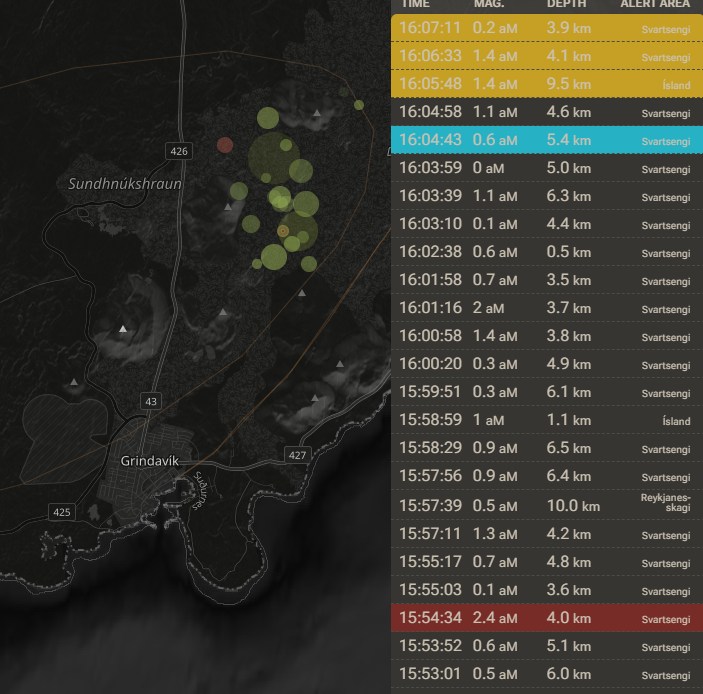
Quake swarm seems to have started 10 mins ago. North of Hagafell.
What it looks like:
Krysuvik involved too.
Quakes going steady … about 25 minutes in …
I’d watch this cam, camera operators already woke up apparently:
https://www.youtube.com/watch?v=Vc037Wp8QeI
Same view, wieder angle:
Looks like the trucks around Grindavik are rushing away too.
Parking right under Thorbjörn. As seen in the Thorbjörn-2 camera.
Tracked vehicle driver finally made it, too. That vehicle’s top speed seems to be slower than lava could run. 😮
Can you post a link to this website to see the live view?
Was it a failed eruption?
Technically yes but when it is a part of a repeating rifting event like this where more eruptions are nearly certain I dont know if calling every intrusion that doesnt surface a failed eruption is very accurate.
Especially not something like this which was small and probably only postponed the next eruption a few days away and may have made it likely to happen further south than otherwise too.
Or it was one kind of the mini-intrusions Hector mentions, that can precede the major intrusions. We are certainly only one to three days before the next “Flash Flood Eruption”, so we must take into account that there already happen pre-eruptive signals.
More or less the same thing, I dont consider the Kilauea intrusions as failed eruptions either if the area then starts erupting. The intrusion in 1961 only erupted in a few tiny places but within the decade almost the whole length of that dike had erupted and Mauna Ulu had opened just uprift of there. I think the intrusion that happened a month ago might be similar, when the pressure recovers another SWRZ intrusion will happen and the more that happens the more likely it will erupt, if it doesnt just erupt next time right away.
Svartsengi also was like this with a big intrusion to start and very predictably all the eruptions have been along that first dike path, including the new tiny intrusion just now.
Blue Lagoon is being evacuated. Sirens going off.
Isak Finnbogason is onsite livestreaming, no lava yet but lava soon I think.
The show must go oooooooooooooooooooooooo……….
(waiting for the ‘n’)
So exciting! Every time! 🙂
What a nice peaceful day at Sundhnukar.
Certainly not a day when the day would open and spit fire.
Quakes are moving southward.
Yeah, just seen that. Uh-oh. 😮
I know, we will know when …
But still, are these remnants from the last eruption or is this maybe water in contact with the ascending Magma?
it’s been smoking like that ever since the quakes started
old lava I’d say
For some reason everytime the Saksunarvatn tephras are mentioned I feel like getting into a car and go for a short drive to Saksun and to pay closer attention to the water and such. Must have been a decade or so since I last was there, even if it’s just an hour or so away.
Watching the webcams like a hawk…
Preliminary earthquake plot (source data from: https://en.vedur.is/earthquakes-and-volcanism/earthquakes/reykjanespeninsula/ )
If I were in Grindavik, I’d be leaving pdq.
Correction: 02/03/2024
It’s getting almost Oh! So! Quiet! again… relative to the earlier swarm I mean.
No quakes for 10 minutes.
This can only mean ONE thing!
It’s going to start soon …
… or it’s stuck and nothing’s happening.
Only one of these things. 😀
One or two more quakes, now at a depth of 2.6km.
IMO are saying that it’s just emplaced a new dyke, and that an eruption is unlikely.
I hope it now emplaces 100 km3.
There have been a few shallower quakes since then so still early days?
Well yeah, but IMO are being quite reactionary.
Took liberties with people’s safety over the course of this crisis in my opinion, so i’m not their biggest fans.
Could you explain what you mean? I think they are doing everything in their power to keep people safe.
If you are talking about letting people back into Grindavik and reopening the Blue Lagoon, I think that was not IMO’s decision. IMO and other scientists advise and others (Department of Civil Protection and Emergency Management?) decide based on risk and how they can manage it.
What a letdown.
Literally. 😀
Have to wait for the next GPS readings. Inflation was going strong until 16;00.
It may very well be over since the earthquakes are largely done, meaning the intrusion is growing no longer. I guess this can happen, but I’m a bit surprised as to why. This time the sill had uplifted a good way above the previous event (looking at the silliest station, Eldvorp) so that pressure must have been relatively high, and the dike doesn’t seem particularly long or extend far laterally which could have taken too much magma for it to overflow. So not sure what changed. Maybe two of the last dikes that erupted in the central part of the fissure swarm opened too much the ground at shallow depths and not much tensile strain was left, which inhibited this intrusion from opening all the way up. This means that the next event may take place sooner that the previous times, since the dike doesn’t seem particularly large and nothing erupted out of it, at least not yet.
Or it wasn’t a magma intrusion but the crust tearing / faults moving to accommodate the uplift? Magma could then flow in at its leisure. Waiting to see what the latest deformation data shows.
IMO mention the possibility of aseismic magma ascent (as occurred with Fagradalsfjall)).
Source: https://en.vedur.is/about-imo/news/volcanic-unrest-grindavik
The last data point of ELDC 4-hour plot doesn’t show much subsidence. It will be more clear with the next point, but maybe there really isn’t that much of an intrusion. Kilauea sometimes does this short-lived event that are very seismically intense while the last but they only do a tiny deflation of the summit. Such events are sort of mini-intrusions and they often precede the bigger intrusions. So maybe this was a mini-intrusion, an attempt at forming a dike that didn’t go too far. If so, it’s likely the real dike will form within a short time (a few days?).
Yes, I think so. We are one to three days before the next eruption very likely happens. So it’s credible that yesterday there was a mini-intrusion that precedes the main erupting intrusion next days.
Inflation did not stop. In fact there might be a slight uptick in the plots (but too early to confirm).
There may have been a tiny subsidence. But overall it doesn’t look like a meaningful amount of magma left the sill. Most likely the real event is still to come.
Unusual depth in the swarm:
02.03.2024 17:21:32 63.590 -23.403 54.3 km 0.6 65.63 11.4 km SSW of Geirfugladrangur
Source: https://en.vedur.is/earthquakes-and-volcanism/earthquakes#view=table
Hello and thanks for great updates from both publishers and commenters.
Having followed this like so many others it might seem like the smoke from the lavafield *could* be a product of increasing pressure. With the current EQ swarm IMO descibes as an ongoing intrusion this fits the picture quite well. Over the recent week I’ve thought that smoke from solidifying lava should decrease, not increase like this afternoon. Thoughts?
Seen here: https://livefromiceland.is/webcams/langihryggur and here: https://livefromiceland.is/webcams/fagradalsfjall
The last one shows smoke and steam on the wrong side of the wall just east of the greenhouse and I don’t like it…
You’re right, the emissions from the lava did seem to increase for a time. I, too, would like to know why, as no lava breached the surface.
Over the last 24 hours, there have been numerous quakes, from 0mlw – 2.7mlw, out in the Atlantic, south and west of the Reykjanes peninsula.
Are these “domino-effect” tectonic movements, resulting from today’s intrusion?
Apparently, not much magma actually moved, so my above explanation seems unlikely.
So, what else might be happening?
O.K, I’m not a geologist/volcanologist. However, I have read on this forum that when there is an earthquake swarm, the automatic algorithms cannot keep up with the rapid seismic input and thus “ghost” quakes are indicated at places where no real earthquake occurred. Perhaps this phenomenon happened today.
I think it’s stopping and preparing to get a run at it.
Fun headline.
Mars had its own version of plate tectonics (Phys.org, 2 Mar)
The news report isn’t very helpful, but the observation that there’re many extinct volcanoes on Mars with higher silica lava plus pyroclastic deposits and suchlike is pretty interesting. The paper is here:
Diverse volcanism and crustal recycling on early Mars (Nature Astronomy, 12 Feb)
A plinian dacite eruption on Mars would be spectacular, Could make it to 100 km and the pyroclastic deposits would spread very widely in the low gravity. Given these were ‘way back 3.5 billion years ago there would’ve been a lot more atmosphere for pyroclastic flows too. Be interesting if Mr Pliny or his son ever climbed Mars Hill in Athens. They got around a fair bit, so they just might’ve.
It’s an interesting scientific article. That said, the supposed volcanoes don’t have any definite volcanic morphologies on figure 2. No viscous lava flow features are discernible in the figure where they show examples of “volcanoes”. The caldera complex looks more like impact craters to me. The pyroclastic shield could be a volcano but could also be a normal hill eroded by water, there’s no definite volcanic detail about it. The “yellow” ground that they think is silicic material in figure 4 does not make up the purported volcanic edifice itself. More evidence would be needed before confirming this is a thing.
https://www.nature.com/articles/s41550-023-02191-7#MOESM1
It would be a bit disingenuous to expect an eruption with every magma intrusion even at a volcano like this. I am not sure if this one will completely fail but if it does it certainly won’t be the only one. This could make the next eruption bigger by allowing the system to build more pressure and magma in conjunction with the established intervals being thrown off. Not very invested in the volcano but an interesting few weeks ahead
To all:
I think we are entering a new phase of fissure eruptions in the Rekjanes Peninsula. The last 3 fissure eruptions have definitely loosened up some of the underground plumbing, so that new sudden flows of magma can occur with more ease. I believe that we will see more dike emplacements then previously seen, before a fissure eruption occurs at the surface.
In regard to the current event, I think the underground magma is taking the easiest way out, and if that means a sudden surge or burst of magma into a dike, then that is exactly what will occur. I also want to add, that these extra dike emplacements are going to make it more difficult to discern or forecast a surface fissure eruption.
One question which I have not had anyone address, is that after a previous fissure eruption we do NOT see the next fissure eruption taking advantage of the weakness in the crust. Does the crust heal up or solidify in such a way that the next fissure eruption is blocked or stymied from reoccurring in the same area of weakness? Do the rocks actually heal up enough and regain their strength such that the next event cannot take the easy way out?
Discussion is needed.
If the dike can solidify then it probably acts as a barrier but with a month between new eruptions I wouldnt expect the dikes to do much, even the surface lava takes days to cool below incandescence below the crust in thin flows, and the ground here is very hot already compared to some old crust areas, so I wouldnt expect the dikes of each eruption to be solid before the next one forms. It is my own theory that the small vent that formed on the edge of Grindavik in January, south of the main fissure of that eruption, was erupted from magma intruded in November last year that was able to erupt when new fractures were opened by the new intrusion that month.
The thing with this new small dike is that if it didnt release much pressure then the eruption is probably still going to happen this week anyway, and now it has opened up a rift further south. The next eruption I think, unfortunately, will be south of the dike origin along the trend of this new intrusion. If it erupts on the north side of Hagafell then Grindavik might be safe, but the lava will probably flood into the ocean within a few hours and if it goes any south of that then the walls will probably be tested to the limit.
Was it an intrusion? Perhaps it was “just” faults accommodating the uplift? There has been no drop in the uplift, in fact the uplift may have increased slightly (but too early to confirm). Magma may flow into any gaps left by fault movement.
No eruption has occurred to date with less than 10 million cubic metres of accumulated magma. Following IMO’s plot, we should reach that today.
The plot is in IMOs post of 29th Feb.
https://en.vedur.is/about-imo/news/volcanic-unrest-grindavik
There looks to have been a small drop towards the SW part of the sill. This is similar to after the January eruption, as Svartsengi hasn’t dropped and may gave risen. I imagine it as a bit like a toothpaste tube, when it is being squeezed from the bottom, the toothpaste gets squeezed towards the top and a bit comes out. If the top had previously been squeezed, then squeezing from the bottom will reinflate the top.
I’m inclined to agree with you. Was 10 million cubic meters of magma really enough to create a fissure 15km long on Nov 10th 2023? I don’t think so.
That event in my opinion was a seismic infill not a magma intrusion. It is the reason no magma surfaced.
The event yesterday was the similar but on a much smaller scale.
No it wasnt but that intrusion was not just a few weeks in the making either, it was probably at least 4 years, including the inflation in 2020, 2021 and after Fagradalsfjall erupted when everyone thought it would erupt in May 2022.
That intrusion didnt erupt because the fault it broke into was too long and it ran out of pressure before it could rise much but in doing so filled in most of the underground leading to subsequent intrusions surfacing very fast and at high intensity. This new dike was very small and likely not the real event, just a weak spot filled in early but not removing much pressure.
Its something important to note that volcanoes that have recently deflated due to a major intrusion or eruption have exaggerated magma supply. Kilauea since 2018 has probably been getting fed magma at a rate of over 0.2 km3 a year on average and maybe 0.3 in since the start of 2023 just to recover the pressure it lost in that year which is only now recovered enough to escape the summit. Bardarbunga likewise has probably seen exaggerated supply after Holuhraun and Grimsvotn after 2011, although not by as high as Kilauea has, hence why I am sceptical of Grimsvotn doing the VEI 4 everyone seems to be anticipating.
But none of those comes close to Svartsengi after November. 0.2 km3/year is a lot but it is equivalent to only about 6 m3/s. The magma flux at Svartsengi after November intrusion was something like 75 m3/s, so for a few weeks Svartsengi was getting more than 10x the magma supply as the rest of all the Icelandic volcanoes combined… The rate is now much lower by comparison because the pressure has recovered and creates resistance to magma inflow, it is about 5 m3/s, and the cumulative uplift at the Svartsengi GPS has exceeded the November limit. With the system now full instead of magma flowing in at high rate when the system is at the limit of failure the supply is low and basically 0 right before an eruption, and pressure increases rapidly.
This also happens at Kilauea too and has got a lot of data supporting it after a century of observations. Magma supply between eruptions in the 60s started very high after 1960 drained out the summit and generally declined through the decade while pressure increased. When Mauna Ulu opened the supply increased as pressure was relieved, until Mauna Ulu grew taller and again pressure increased, causing instability in the eruption and abundant intrusions and small eruptions elsewhere on Kilauea through to 1974, and ultimately pushing the south flank out of the way in the 1975 earthquake. Pressure was again low causing a surge in supply to refill, leading to eruptions and intrusions near the summit by the early 80s. It did so again and much more when Pu’u O’o opened in 1983 and supply was sustained at a high level with Pu’u O’o so much lower than the summit. In 2018 this was only amplified even further, leading to the very high supply at present.
Svartsengi has basically done all of that but on a smaller scale and in a few months so the whole process is clearly visible. Its all hydraulic pressure basically. In more gas rich magmas it gets more complicated but the volatile poor and very fluid magmas in Iceland and Hawaii follow this trend well. I might write an article on it some day if I can find the time and locate where I actually found the info originally.
The GPS trajectories clearly show the combination of a small sill deflation and a small dyke intrusion. The key is as usual to look at horizontal movements. This event was very similar to the January event, with the exception that this one didn’t erupt.
The changes are small, so this will just delay the next event by a few days.
It’s possible that the Grindavik Fires will get a fixed vent with an open magma channel for recurring episodic lava floods. If we look at the map layers of past “Reykjanes-Svartsengi, craters”, there is a cone of Midhæd east from Hagafell that looks like a possible pre-historical recurring eruption vent. Towards the north (Dalahraun) there are several more thick red dots for past vents.
The present distribution of earthquakes along the whole peninsula reminds me to the days before the last eruption. Does the pre-eruptive pressure cause tectonic quakes along the peninsula?
One day of Monday to Wednesday must be the start date for next Grindavik episode. Feb 10th + 25 days are Wednesday March 6th. If it’s faster it can happen on 4th or 5th March.
How often did ash clouds from Iceland leave tephra on Scotland/Faroe/Skandinavia?
Eyjafjallajökull 2010 and Grimsvötn 2011 sent ash clouds to Europe, but without ashfall. I remember that during the years around 2000 (Hekla? Grimsvötn 1998/2004?) an ashcloud according to TV news got to Norway, but likely no ashfall.
Sorry to differ, but actually ash from Eyjafjallajökull did leave ashfall in the uk which was mostly noticed as fine ash on cars. I only remember because the news outlets were warning to not wipe the ash off of cars because of the high risk of scratching glass and paintwork on the cars. They were recommending to hose it off or rinse off with copious amounts of water.
The ash though was VERY fine and very small amounts only in some areas and not others.
The thing I adored about the Eyjafjallajökull ashclouds was all aircraft over UK being diverted or grounded. To see a wonderful blue sky with none of the irritating con trails that ended up as clouds was wonderful. No overflying aircraft messing up the sunny weather. Sadly I dont recall it lasting longer than one day.
Before Eyjafjallajökull I believed that they only shut the sky for planes, if you actually can see the tephra plume/cloud from the plane. It was irritating that they had to shut the sky completely, although the sky was clearly blue in many parts of Europe without any visible tephra.
There was an incident with a BA plane in Indonesia several years ago that suffered temporary engine failure. The pilots managed to save the plane, but the paint was essentially sanded to bare metal.
It doesn’t have to be visible to have an affect.
https://www.volcanocafe.org/volcano-stories-ba-9-mount-galunggung-and-the-penguins-of-mount-terror/
This was indeed some kind of slight ashfall, maybe comparable to Sahara sand that sometimes falls in Europe as dust on cars. Was there also a visible ash cloud in Scotland or England?
No visible ashcloud in my part of Scotland (Western Isles) although we did wake up to our cars being covered in a very thin layer of fine ash
It wasn’t visible as such, but it did affect the intensity of sunsets in the southwest. Also, it appeared as dust on cars.
I think the cloud and ash reached us overnight which is why we never noticed the ash cloud. As you say, it was very fine.
Saharan sand was far thicker on the car, I was once drivng with my son in the rain and suddenly a red sludge formed on the windscreen and we were really thankful when a mile down the road we came into torrential rain again that washed the car clean.
Also we had one day where the sand in the clouds was so dense that it turned the whole town into a red gloom. A nervous friend phoned to ask me what was happening. I think she thought is was the apocalypse! That day the sand in the clouds extended across an appreciable area of southern UK.
These episodes can be very sporadic in nature. One area gets it, another place misses it.
https://en.vedur.is/about-imo/news/volcanic-unrest-grindavik
Where has 1million cubic metres of magma gone to? Or is pressure building faster?
A good question, I do think that the IMO will have to correct this graph sometime very soon.
If nothing has surfaced where has the magma gone?
Why does this graph ignore the time period between Nov 9th and Nov 19th 2023?
According to GPS things were still moving up at the SENG GPS station.
We should enjoy the beautiful view of Grindavik today, before it may get a bad day like Esgaroth in the Hobbit tale.
Udun might be a better analogy if you’ve watched the Rings of Power!
After thinking about this for a bit, I dont think there can really be any meaningful way for the Svartsengi sill to deflate without erupting now. Maybe if the dike in November was smaller then there could have been extra tension to need filling but instead it pretty much filled it all in one go. The dikes since have all been small, and the eruptions intense suggesting they began while the sill was deflating and not from supply like at Fagradalsfjall. So basically 10 million m3 is enough to break to the surface in under an hour, with majority eruption, and this volume is replaced in under a month. An intrusion that doesnt reach the surface will either need to push the crust apart more than in November, which had 10x the magma volume to do so, or it will be only a small percent of the volume of the eruptions and thus have minimal impact on the system pressure.
If it was overpressure that caused this small dike just now then it has delayed the next eruption by 2 days, 3 at most. The next eruption will be on the 5th March local time, maybe on the 6th. My bet is in the same area that just cracked too, at the southern end of the Dec/Feb fissures and north of Hagafell, basically where Sundhnjukur itself is. This is the area that flowed right into the ocean when the last eruptions in this fissure happened, and the walls will probably be put to the test big time.
There was a tiny bit of deflation immediately before the Jan 14 eruption at SENG (shows best on the 4 hour plots).
Sorry, meant the Feb 8 eruption (need new specs!)
The police will reassess whether or not to reopen Grindavik at 15:00 today.
Source: https://www.ruv.is/frettir/innlent/2024-03-03-taka-stoduna-a-opnun-grindavikur-aftur-klukkan-1500-406471
Better let it remained closed until the next eruption is over.
The warning signals will next time likely be increasingly shorter. If this tendency continues, we may get eruptions without any warning like earthquakes like to happen.
No idea.
I’d guess to discount any rebound from the graben formation but I could be wrong.
Interresting with the decrease in activity after what looked like a clear run-up to a new eruption along the dyke yesterday afternoon. I have thought about this and have two theories;
1. The connection between the sill and the dyke has puzzled me a bit. Now we have seen a (for now) “failed” eruption, but there is every sign of magma beeing present in the dyke so I propose this; what if the connection btw. them is fairly a the top of the dyke and at the same time close to the top of the sill. with the channel btw. formed as a bowed bridge with the top higher than the dyke?
That would explain why the sill doesn’t fill much untill in the late stage, why the eruptions are fairly short and that the sill deflated some overnight (GPS Eldvorp and Thorbjörn ++). With “a bridge” in place the magma can’t go back in the sill once in place in the dyke, but lack of enough gas/backpressure/feed prevented it from erupting. For now. So *all* we got was degassing at surface. If the connection was on an incline from the sill I think we would see more steady rising activity along the dyke as apposed to quick run-ups.
2. The deeper seismic activity might be tectonic rifting. A deeper rifting happening *before* surface rifting could explain the whole run-up to these Reykjanes episodes. The fact that we see large vertical tectonic movements at surface only at the time of the eruptions (steady inbtw) could support this. Along with fairly deep EQ-activity in the run-up period. Eventually widening the deeper feed over time. We simply do not know the North and Eastward movement at the deep. But looking at most things in nature there is a profound difference btw. warm and cold stretching. Cooled steel stretched will snap, while heated steel will stretch for instance. This mechanism *could* also explain why the inflation subsided overnight as seen in the comment above.
What we see is difficult to know – and I am not a scientist – but if we consider the long lasting historical fires in Iceland it isn’t out of the question that episodes of fast tectonic rifting gives the conditions needed to sustain the fires, and that these fast tectonic shifts run so deep that there is no reservoir to speak of because they are in essence mantle-driven due to the *opening* occouring through the upper layers of the crust. Thus producing year-long fires. The run-up to these historical fires could simply be that the deeper rifting happened before the surface rifing. So if deeper rifting happened yesterday that also could explain in some part why the volume *fell*. Exept it didn’t. More room was simply created vertically in combination with filling the dyke. I would think that wo. such a process Reykjanes would still be quiet. Any thoughts?
Woops.
“That would explain why the dyke doesn’t fill much untill in the late stage” Not the sill. Silly of me…
Fernandina has just erupted.
Info?
https://www.mirovaweb.it/
Powerful heat signature.
https://igepn.edu.ec/servicios/noticias/2106-informe-volcanico-especial-fernandina-n-2024-001
https://www.google.com/amp/s/www.laprensalatina.com/volcano-on-galapagos-islands-begins-eruption/amp/
More just in case… there are lava flows.
https://www.facebook.com/share/v/LxxLu2vijuWe9PR4/?mibextid=Nif5oz
Seems to already reached the ocean.
https://www.facebook.com/share/p/1F4EbCjzVHJkSZKM/?mibextid=Nif5oz
More photos in case.
https://southamericatravelcentre.com.au/fernandina-islands-volcanic-eruption-galapagos/
Not really sure if they are latest photos, but very interesting…
Shame there is no good view, it is probably an intense fissure eruption like Svartsengi but larger. Says it is probably a larger eruption than the last 3 were
Original source: https://www.ctvnews.ca/world/volcano-on-uninhabited-galapagos-island-erupts-sends-lava-flowing-to-sea-1.6793036
This one photo is very dramatic, at least for me. It simply reminds me of a beginning of an apocalyptic event. The way the plume just darkens area amongst the lava flows with the lit summit just makes it seem surreal…
VD has article with photo + video: https://www.volcanodiscovery.com/fernandina/news/235837/Fernandina-volcano-Galapagos-Islands-new-eruption-numerous-lava-flows-from-flank-fissure.html
Looks like a very intense eruption, wouldnt be surprised if it ends soon but it has been 4 years since the last eruption so pressure could be higher.
Seems like there is a long fissure that runs partly circumferential to the caldera, and another fissure going directly radial to it and almost edge on to the video view. The eruption is apparently in the same area as the 2020 eruption
Report by the national monitoring institution: https://www.igepn.edu.ec/servicios/noticias/2106-informe-volcanico-especial-fernandina-n-2024-001
They describe the eruption as ” a circumferential fissure located high on the southeastern flank.” (translated by Microsoft translator)
Deformation: “2020, using InSAR technique using data from the Sentinel-1 satellite, a positive deformation has been recorded in the center of the volcano’s caldera of approximately 80 cm/year, which would be associated with the entry of magma into the interior of the volcano.”
Quite apocalyptic looking.
https://www.vidlii.com/watch?v=s5Xl_OeMth1
Any chance of being able to down load earthquake data as is from Skjálfta Lísa without it rounding the depth to the nearest Km?
Merlot:
I took a careful look at this via the Mozilla Firefox debugger and the data is downloaded using web grab or moz grab feature, from a data repository not visible in the html code. So I am afraid you are out of luck in getting it directly from the webiste skjalftalisa.vedur.is. You can grab the current 24 hrs of data not rounded in depth from the https://vafri.is/quake/#close page, by doing a whole web page save and obtain the generic html header page and a folder of files. Looking inside the folder, you will see a js file titled index.js, that is the data you are looking for.
I too, wish that the data was not rounded off in the IMO database for public display.
Be aware that the uncertainty in the depth component is larger than the round off error. Maybe leaving the decimals out isn’t such a bad thing agter all.
But if you do want the decimals you can get the data in table format in Skjálfta-Lísa. Just click on the top right icon to go to the graph display, then on the left side is a selection of icons that selects different plot pages. The top one is table data.
Nice, I didn’t notice this, thanks Tomas
The decimals showed on screen but were lost on download.
Example
There’s also an api for Skjálfta-Lísa, which is probably exactly what you want. The /quake/array interface seems to give full precision, while the other ones give the rounded depth.
https://api.vedur.is/?urls.primaryName=Skj%C3%A1lftal%C3%ADsa
Thank you. is that a publicly available app?
It looks very public. If you click the terms of service you get linked to this page:
https://en.vedur.is/about-imo/the-web/conditions
The terms are really generous. When using the data you should leave a reference to the Icelandic Met Office and state the date you downloaded the data. Unless stated otherwise, there are no restrictions on the use of IMO data, neither for private nor commercial use.
The API returns data in json format. In order to present the data you need to process it yourself in your preferred coding language. Python is probably the way most people will go these days. Data goes back further than in Skjalfta-Lisa, but if you want data that spans more than one year you’ll have to do several requests. Happy hacking!
Hacking?
As in “have fun writing your code”. Maybe that’s not a universal expression. To me a hack is just a quick and dirty piece of code that does what you want without any ambition of being well written or thought through.
I could just ask IMO to change the setting to one decimal place.
I’m too accident prone to get adventurous on someone else’s servers.
But you’re not changing anything on the IMO server, you just query the server and get data in response. What do you want to do with the data?
Live in the South West of the UK (Exeter). The weather was very fine at the time and I recall there was an intermittent faint, orange “haze” observable on one day. Deposits were very obvious on vehicles. They visually looked very similar to Sahara dust deposits that are not uncommon down here in the south west of the UK but slightyly heavier and unlike Sahara dust it felt incredibly coarse and abrasive. As Alice said, the most memorable thing after the haze passed were the gin clear skies without any contrails!
And this is how it looked at sunset.
https://ps.avalonlightphotoart.co.uk/image?&_bqG=1&_bqH=eJwLd7XwdzTVNSxMdTPKTDeJ9Mk1tHR29orMLDaxMrEyNDAAYSDpGe8S7GzrWJyhBmbFO_q52JYA2aHBrkHxni62oSBVwcF6WaYVqZYh5ulq8Y7OIbalxUXBqYlFyRlq7iBFas4gEgBZjSE7&GI_ID=
A beautiful sunset photograph Richard. Thanks for linking it.
Thanks Alice. The other shot I have uploaded is closer to the orange Swebby described. The dark strip of the ash on the horizon is also visible.
We had the same. It was weird finding my car coated with fine volcanic ash. New one for me! I’m quite used to Sahara sand – wretched stuff.
Thanks for sharing your personal experience! Was it during Eyja’s or Grimsvötn’s eruption?
Both were VEI4. Eyja 2010 had the advantage of a favourable wind direction towards Europe.
Saksunarvatn had a VEI7, so appr. 1000 times larger.
Katla 1918 was VEI4 to VEI5. Was there any stronger explosive eruption on Iceland during 20th century?
During 19th century Askja had its famous explosive eruption 1875 (VEI5?) which sent tephra to Europe. It likely was Iceland’s last VEI5.
The image above was in April 2010. I think the winds blew away from Europe during Grimsvotn’s eruption.
Grimsvötn 2011 also had a stronger intensity and higher ashplume until stratosphere. Added to this the eruption was much shorter (6 days) than Eyjafjallajökull.
Saksunarvatn shows that Iceland can do eruptions until VEI7. Can we estimate how thick the ash layer was f.e. on Faroe islands?
There’s a reason for that, which I’ve mentioned before here, a few years ago. . It’s all to do with thorium concentrations.
Laki, with a huge volume of ‘fresh’ magma, was low in thorium.
Over the following centuries, there was a progressive increase in thorium concentration in Grimsvotn eruption products; this is interpreted as being due to concentration and fractional crystallization in shallow magma chambers. The highest concentration was in the 2005 eruption; in a geochemical sense, that one marked the ‘true’ end of the Laki eruption!
Then in 2011, the thorium was completely different, back down to low thorium, similar to Laki itself. It certainly appears that the 2011 eruption signaled the arrival into the system of a new, fresh batch of magma from depth.
Olgeir Sigmarsson did some work in this area, I recall.
Were there any other elements that show this trend? Trace elements are important but the bulk elements are likely to be more important generally. Grimsvotn notably in 2011 had a relatively low MgO concentration hovering around 5% by weight and max of 7%. Found in this paper:
https://agupubs.onlinelibrary.wiley.com/doi/full/10.1002/2017JB014067
Compare this to Laki, which was 5.8% MgO, consistent with being fed by the same source as Grimsvotn. But compared to the lava of Bardarbunga which has on average over 7% MgO, it seems unlikely a huge volume of deep magma from the plume rose up or the MgO content would have likely gone up. Same for Laki too. Most likely there is a large volume storage complex below Grimsvotn, but not the structure Carl describes, as Grimsvotn doesnt seem to be the plate boundary so shouldnt experience continuous strong extension. On rare occasions that it does and there is a rift (Laki) it seems the deep plumbing ruptures into it. Bardarbunga being the actual plate boundary probably does have more elongated storage and likely continuous melt generation to fill the boundary.
MgO for recent eruptions at Fagradalsfjall was around 9%, and Svartsengi similar. MgO for Kilaueas lava during the Pu’u O’o era was between 7% and 9% and as high as 13% in 1959, being borderline ultramafic. So Grimsvotn at about 5% is relatively low and indicates it stores a lot of its magma for a relatively long time deep in the crust and it doesnt get supplied at constant high rate like Bardarbunga or especially Reykjanes or Kilauea. What might have happened in 2011 is magma from a deeper pocket rose into the magma chamber and diluted it. The deeper stuff might have had a common source with the Laki stuff. I dont think what happened in 2011 had anything else in common with what happened in 1783 at all or that it has any bearing on how big the next eruption will be. But this is just my own theory.
We got ash in Europe from Grimsvötn, too.
Eyja for me.
Noticed there was a swarm of shallow earthquakes at Keilir today. As well as a few deeper ones closer to the 1st Fagra vent. I still do not think the 2 (Fagra/Sudnuhkar) are linked.
They may share a source in the upper mantle / lower crust.
Lilti Hrútur has grown a bit since I last looked ;).
I think the next eruption is extremely likely tomorrow Tuesday 5th March or after tomorrow. Probably similar location as previous eruptions. Perhaps further north now?
We had earthquakes and it’s about time for it.
Time will tell if my guess is correct.
And great article, which I will now finish reading.
That’s it sorted, no eruption today, yesterday or before yesterday then.
Covers all of time in combination.
(sorry, couldn’t resist).
Or did you mean day after tomorrow?
??? It is late so my brain might be adled but sorry farmer from OZ but I dont understand what you mean. ???
To me Irpsits post was perfectly understandable…. or did I miss something?
I think he was joking how Irspit said he predicts an eruption either tomorrow or sometime after that – which encompasses all of future time.
Certainly makes the prediction more likely to be correct that way!
While also acknowledging that he probably meant tomorrow or [the day] after tomorrow.
As you say, it was clear what was meant.
Now I am getting worried. I still cant understand even this morning when I have slept well? As I am now on the further side of my 70’s I now get worried by the brain befuddling I get at times. Ah well, Thanks for the explanations and hope I never upset anyone!
Not helped by me making a similarly erroneous reply for added potential humour!
Been a long month …
It is the 5th ..
The question is now, will it or won’t it? I hesitate to put dates on eruption predictions but admire people willing to do so!
Almost certainly by next Wednesday, when the accumulated volume should reach 13 million m³.
The 25 recurrence time ends tomorrow. If it repeats this timeframe, the 4th eruption must be tomorrow. But the intrusion of 1 mio cubic meters magma likely has changed the timeframe a bit.
However, I hope that it’s not the end of Grindavik. Sad to see how a city/town/village is lost in lava/tephra/PC flow.
There are a few ways of looking at it, beyond the couple below.
1. The pattern reducing by two days held, if you look at the day of intrusion, so the sequence was 27-25-23.
2. Approximately 3 days worth of magma intruded into the dyke area, which may have delayed potential eruption by 3 days.
Point 2 also fits with inflation reaching the same level tomorrow.
Some other interesting things I’ve noticed, is the larger lateral movement was with the January eruption, but it had the lowest deflation. Does this mean different percentage differences between intruded magma and extruded lava in each eruption? Could this add weight to one suggestion that the January eruption was leftovers from December, that was pushed out by the intrusion that mostly just recharged the dyke? Was the weekend event the equivalent of January or is there more to come? The February eruption resulted in less deflation than December.
The graph of intrusion at Grindavik’s volcanic system reminds me a bit to Grimsvötn’s graph with accumulated quakes since 2011. There appears to be a nearly mathematical model behaviour, but with a lot of uncertainty on what the volcanoes actually will do when and how.
As Carl writes in the current Article, Grimsvötn consists of ” 6 en echelon central volcanoes”. On a small scale a similar development of different volcanic centers of eruption appears possibly currently on the Svartsengi system. There is the deep horizontal sill with several spots of possible vertical dikes.
If we look on the map layers of ancient Svartsengi craters, they go all the way from Grindavik to the northern slopes of Fagradalsfjall’s “Thrainsskjaldarrhraun”.
There is one center of pre-historical activity on Melholl (southern slope of Hagafell) and a different one on Sundhnukur. I have the impression that the eruptions have switched a bit between both centers. The January eruption was close to Melholl ancient craters, while the December and February eruptions were close to Sundhnukur. It’s possible that both systems over time are going to shift from fissure eruptions to sustained volcanic cones.
It may something lost in translation, but it’s interesting that IMO are referring to a magma reservoir rather than a sill.
Did anyone see the YouTube video from Isak Finnbogason’s today? He showed a drone flight of the lava field but what was most striking to me was the heat signatures of steam coming from the side of Stora-Skogfell.
To me it seemed bizzare and I couldn’t see any explanation for it.
I wondered of anyone on here could give an explanation for what could be causing it?
Hydrothermal?
Alice, just to chime in, last night I watched the steam emissions for the lava field on one of the Live from Iceland cameras, https://livefromiceland.is/webcams/langihryggur and it seems like they’ve picked up a bit since this latest dike emplacement. I wish there was a way to quantify this, Isak Finnbogason took his drone up and he had it skim over the steam emissions in the latest lava field… but I don’t think anyone really has been making “quantity” measurements of these steam emissions.
It rained there recently. It’s probably that. The same happened with past fresh lava flows when rain hit them, here and at Fagradalsfjall. It evaporates, then condenses again in the cold air above and makes visible plumes.
Actually Isak Finnbogasson took up his drone on an absolutely clear day, the same day and an hour or so after the quake swarm, while they were still evacuating the Blue Lagoon.
The gas emissions were quite prominant, so much so that he took time to put the drone down lower in altitude to take a look. It just appeared to me that these gas emissions increased a slight bit after the quakes, as I watched them for a day or two after this event from the Langihryggur camera.
Lingering moisture in the ground?
It’s just above the edge of the new lava field. Maybe cracks and gullies in the hillside can channel the steam from the lava so it looks like it’s coming from the ground?
Actually that seems a good possiblity. I hadn’t thought of that. As the steam and heat signature wasnt coming from the bottom but from the side it confused me. Easily done nowadays! As written above.
No eruption but the Northern Lights are showing up well on some of the webcams.
I take back what I said about Chiles-Cerro Negro being quiet for the next several months or year. Over the last 3 weeks, it’s been churning out VLF quakes at an even higher rate than before. The same quakes that preceded the 2022 and 2023 seismic crisis. IGEPN not reporting anything only the SGC is doing their job now.
Well your comment made me have a little look around (I was looking for links to the plots for the VLF quakes) or any obvious reports – I didn’t find that (I only looked quickly) but going here
https://miig.sgc.gov.co/Paginas/Resultados.aspx?k=BusquedaPredefinida=DGBRecEstGeoVolc
which takes a moment to load up links to 14 studies on Chilean volcanism at the bottom of the page – hmm looks like it lets you follow those to a download link but you have to enter your email and request the actual data (assuming I managed to read the spanish correctly).
Might be something interesting in there – nothing about Cerro Negro directly as far as I could tell but I’ll leave you to glance at the titles and see if there is anything worth pursuing – sorry if this is somewhere you’re already familiar with.
“The record of associated seismic events was also maintained
with movement of fluids within the volcanic complex, some of them with very low
frequency.”
https://www2.sgc.gov.co/Noticias/boletinesDocumentos/Boletin_semanal_de_actividad_del_volcan_chiles_cerro_negro_del_6_al_12_de_febrero_de_2024.pdf
Never in the last decade of tracking this volcano have I ever seen them mention VLF quakes in the weekly reports even when they did occur. All of the data from seismograms are no longer public
Over 500 VLFs in the Feb, the most ever recorded at the volcano.
If you look at the 8-hour Svartsengi crustal deformation (GPS) chart covering more or less the previous 90 days, you’ll see a continuous ratcheting up of the elevation of that area. That same step-by-step increase can be seen in the charts of adjacent areas – with each eruption or propagation not deflating those areas not enough to keep up with the inflation over time.
I was going to say that obviously this inflation can’t continue forever but decided maybe that isn’t so obvious. For all I know this ratcheting behavior can continue for a long long time.
Apologies. Should be,
“… with each eruption or propagation not deflating those areas enough to keep up with the inflation over time.”
4.8 Earthquake on distant Reykjanes Ridge (MAR) 56.8°N half distance between Iceland and Newfoundland: https://earthquake.usgs.gov/earthquakes/eventpage/us6000mgud/map
It’s very far from Iceland, but it still is labeled “Reykjanes Ridge”. On 59°N was the last submarine eruption around 1990.
Kilauea has recently done some DI events, if I interpret the graph correctly. When can we expect the next intrusion?
“When can we expect the next intrusion?”
If it’s in the rift, then the connectors will flare-up with intense seismicity before that happens. And probably do some short-lived intrusion-like earthquake swarms.
If Halema’uma’u then it’s more tricky. The first 4 Halema’uma’u eruptions after 2018 were from cone sheet intrusions that were preceded by intense, widespread summit seismicity across the caldera, Kilauea Iki and the Nāmakanipaio Campground. But the last Halema’uma’u eruption which came from a dike had practically no seismic warning within the caldera. Only a small microearthquake flurry under the southern caldera floor about 2 days earlier or so, and a few sporadic Halema’uma’u earthquakes.
For the time being the volcano is replenishing magma, which might take a while since the dike intrusion a month ago took away an important volume of magma from the summit reservoir. It involved much more volume that any of the summit eruptions in 2023.
If the summit GPS is a guide, then maybe another month or so. Certainly unless something major happens immediately Kilauea will be ready to go well before the end of the year. The SDH tilt will need to rise but we saw it go up hundreds of units without anything major so I dont expect that to be much of a limit.
My guess is the SWRZ will gradually increase in seismicity possibly quite erratically and a new intrusion in May. Which may or may not erupt too but probably has a better chance now that some of the space is filled. The intrusion a month ago was large but not huge and only set Kilauea back to its September level, which might well not be entirely coincidental too.
I think our next Svartsengi event will be about the 12th or 13th, as the most recent one reset the inflation about 10 days worth. Though I do wonder if the continued stretching of the sill area will eventually cause a new behavior to emerge at some point.
I agree with your date prediction.
Based on the volume loss to the dyke, ~1.3 million cubic metres, and a inflation rate at about half a million cubic metres per day. That puts the loss at 3 days worth, so it could be any hour… or any day now… as long as it behaves as it has been doing.
Data from IMO: https://en.vedur.is/about-imo/news/volcanic-unrest-grindavik
Latest chart up to yesterday
The graph shows a comparison of volume increase within the Svartsengi reservoir prior to dike propagations and/or eruptions. The status of the volume change as of 4 March is indicated by the red line. This line also shows what affect the magma propagation on the 2 March had on the accumulation process within the magma reservoir beneath Svartsengi.
The model suggests that the loss of magma from the sill continued for two days, although I’m not convinced the GPS data shows that. They did say that the INSAR data will improve the data for the model.
Richard, for Svartsengi that model doesn’t match but for Eldvorp it appears to me to be a perfect match.
I have also noticed that for the previous 2 eruptions it was Eldvorp where the GPS dropped and not Svartsengi. Svartsengi appeared to have just a tiny drop then regain height where it has mostly stayed.
I had always assumed the eruption lava came from Svartsengi but as it is only Eldvorp that has shown any appreciable drop, and for the last 2 eruptions it seemed to wait until Eldvorp was at maximum before erupting, then I am wondering what exactly is the truth here?
If this is truly the case then I would suggest at LEAST 2/3 days until eruption again from when Eldvorp begins to fill.
SKSH and HS02 also dropped, but only on the day of the intrusion. I equated it to squeezing the end of a toothpaste tube above. The mechanism is different, but similar results.
A very good analogy. I assume Eldvorp would be the end of the toothpaste tube and Svartsengi to top or exit area. Thanks as that puts an intersting light on the situation for me!
Would that mean that Eldvorp would not need to reach former heights before an eruption? The tail not needing to wag the dog in effect?
If the 4th episode is delayed, the chance for two eruptions in one months is nearly gone. Only a recurrence time until 30 days would accomplish two episodes in one month.
I am still trying to work out what happened on the 2nd March with no success,
At what depth did the quakes happen on that day?
Was it at 5k which suggests the magma chamber has shifted east, or 3k which suggests the magma has moved up to the dike.
It was a small dyke intrusion, nothing to do with a magma chamber moving, just a small squirt from it:
From IMO:
“Model calculations indicate a volume loss of about -1.3 million cubic metres from the Svartsengi magma reservoir on Saturday – which fed a 3-km long dike intrusion between Mt. Stóra-Skógfell and Mt. Hagafell. The volume loss from the Svartsengi reservoir was much lower than that which occurred during previous events, where a volume loss of about -10 million cubic metres was calculated.”
I just want to know the depth of the Mar 2nd event, not what the IMO tells me.
Most of the quakes in the swarm were around 4-5 km.
Previous events also started around the same depth, then propagated upwards.
You could use the earthquake data from the timescale you want and plot it – this should give a rough guide to how long (already stated) and how deep the dyke was. I answered the other part of your comment – it was a small dyke that formed, rather than a shifting magma chamber. This could have been a small parallel dyke to the main Nov 2023 one, following a weakness in the crust along the many faults that are parallel to each other along the graben. It’s highly fractured and magma will jump from fault to fault depending on the easiest path.
Along with this paper to help visualise it:
https://www.science.org/doi/10.1126/science.adn2838
You might need to do some double difference relocation then; free depths of individual shallow earthquakes are notoriously uncertain, but DD relocation can help constrain them.
ahhh, sorry…. i think my FB account has been hacked… not sure. Just can’t get into it. So this is a warning to all my friends. Sorry, Carry On.
Don’t worry mots, it’s a global issue with the servers:
https://metastatus.com/
Yes, it zapped messenger and reset all 3 of our (mine, my wife and the cat) FB users so we had to log in again. The horror – I hadn’t saved any of the old passwords and all 3 accounts are linked to the same phone number. Got there in the end.
Mots, the BBC are reporting a global outage of FB and Insta… I don’t know about whatsapp, but it seems that there are issues with platforms run by Meta in general.
Also thought I was hacked, too, but solved it by clearing cache data. Runs fine now.
A post on the IMO to the right hand side on their home page caught my attention: https://www.nature.com/articles/s41586-022-05083-4 Deformation and seismicity decline before the 2021 Fagradalsfjall eruption
Seems to be quakes happening all along Reykjanes now, which has been a loose indicator that a new intrusion will probably happen soon in the next day or so. Which is about when a lot of us have predicted.
One thing I have been wondering but Reykjanes seems to have a pretty straight line of mountains where the side facing north (towards Reykjavik) seems more disturbed and the south flank is low angle and as expected for a mafic volcanic field like this. But the plate boundary seems not to follow this surface though, it curves roughly parallel to the south coast and then avoids all of the volcanoes. I know on here Hengill has been described as a triple junction volcano but the main boundary seems to actually be distinctly north of the boundary. Same for Brennisteinsfjoll, but Krysuvik to Eldey actually do appear to propagate dikes from the plate boundary itself. Fagradalsfjall so far has not but may be undiagnostic with how long it has been before the recent series.
Its also interesting how many quakes are near Hellishieldi. I always assumed them to be related to the wells but they seem to be deeper than that unless the wells are way deeper than I was aware.
The border between systems on Reykjanes peninsula is maybe gradually. If we look f.e. on Gjalp 1996, it was a partially Grimsvötn and partially Bardarbunga eruption. Fagradalsfjall has prehistorical craters and fissures on the north-western side of the plateau towards Svartsengi’s Dalahraun. These fissures/craters are more than the 2021-2023 fissures leaning to Svartsengi’s system. They can possibly act as intermediate volcanic fissures/craters between Fagra and Svartsengi like Gjalp between Grimsvötn and Bardarbunga.
Really the only thing that seems to be a reliable rule is that central volcanoes dont intrude into each other.* The fissure swarms have no hard boundaries they just tend to be dominated by whatever source of magma is easiest to erupt there.
* That includes Torfajokull. The rift thay both erupt from does seem to be continuous, but the Torfajokull vents are always noticeably offset from the Bardarbunga vents, which implies Torfajokull creates its own dike in that part of the rift rather than Bardarbunga doing all the work.
Torfajökull is a system with evolved magma that 500-600 years ago erupted when probably basaltic magma from Bardarbunga intruded. Gjálp is an example on Vatnajökull. Gjalp eruptions are fissure eruptions on Vatnajökull, when the fissure swarms of Grimsvötn and Bardarbunga interact.
Bardarbunga created the rift that opened in 1477 and 871, which in both cases rifted through Torfajokull. But the Bardarbunga dikes both stopped in the low area near the river. Torfajokull made its own dikes, in 1477 it was nearly entirely rhyolite and effusive it seems but 871 was more dynamic and rather more extensive.
So basically one tectonic structure and two volcanoes erupting into it.
The same thing probably happened during Eldgja as the northern 3rd of Eldgja is tholeiitic basalt that cant have come from Katla. The parent is unclear though it also wasnt very intense unlike near Katla so possibly it was a passive intrusion without deep recharge that just took advantage of the new rift.
These big rifts are more complicated than they look is what I am getting at 🙂
Eldgja followed a pre-existing rift. Presumably the area closest to Vatnajokull had an older magma remaining in it, which was reheated and pushed out by the Eldgja magma. Magma from different volcanoes can certainly reach the same region and interact. Having two volcanoes erupt simultaneously in the same rift would be harder to envisage, but remnant magmas can easily come from different sources. Rifts don’t like to go uphill, but where that is not a problem it should be easy for this to happen.
I used to agree but after exploring the area on google earth and mapping the relevant eruptions that explaination doesnt really make the most sense anymore. Torfajokull actually is pretty elevated, not compared to Bardarbunga itself but it is taller than Veidivotn and Tungnaa, and is inflating at present so does have its own magma system after all.
Around 10 o’clock GMT there was an earthquake swarm near Reykjanestá. The strongest quakes had Magnitude 3.0. They occured at depth of 4.5-6 km.
The GPS for Kryusvik clearly shows the expansional forces by Fagradalsfjall and maybe also Svartsengi:
Popo seems to be in a grumpy mood this morning. Bad burrito last night?
Popo is busy today and yes he has the coughs or hairballs or whatever it is that volcanoes do when they huck up a bunch of ash. There are now piles of ash all over and no more snow on the mountain.
Ash altitude is pretty high given the size of the mountain.
This is my personal opinion. The latest dike emplacement which occurred on March 2nd indicates that the overall behavior has been changed from our expectations. While it is easy to forecast future fissure eruptions from a certain stepping sequence in the GPS readings, I think caution is now required. I expect more small spurts (dike emplacements to occur) before a surface fissure eruption occurs.
Thesw tiny intrusions can only go so far though, so there is a very limited range between them starting and not reaching the surface. The supply is such that they can happen multiple times weekly which sounds like it would make an open vent before long
I both agree and disagree, there is only so much space magma can intrude into in the dike without erupting given the thin crust. But I do think eventually eruptions will start in the west towards Eldvorp, which is just my own little theory.
Ok so activity may head back to the Eldvorp area. I decided to give past flows another look. The last Sundhnúkur eruption was 300bce. But just west of the 1230’s eruptions I noticed two shields. Turns out they erupted in 200bce. I marked out the lava flows on this map.
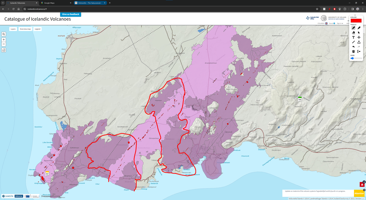
To be fair that is potentially a century after and so far this episode is a few months in… Same thing about the eruptions in the 1200s, Eldvorp isnt given an eruption date assigned specifically but Illahraun and Arnarseturshraun were erupted in 1240. They also both pretty clearly erupted from different dikes and Eldvorp seems to have been an episodic extremely intense fire fountain series while Arnarseturshraun became more of a shield.
GVP does also give estimated volumes of past eruptions of Reykjanes volcano (=Svartsengi+Stampar+Eldey, basically everything east of Fagradalsfjall)
Eldvorp was 0.28 km3
Arnarseturshraun + Illahraun was 0.37 km3
Klofingarhraun, which is one of the shields you outlined, was 0.16 km3. Its apparently unclear how old it is, just older than Eldvorp.
The real elephant is, maybe most unfortunately, Sundhnjukur. It apparently erupted 0.52 km3 last time… If you combine Eldvorp and Arnarseturshraun it comes to 0.65 km3 which is more but not much more. There also is the fact Arnarseturshraun is a bit atypical being a shield and not a fissure row or fountain cone. Unfortunately I think it is just wishfull thinking to expect the eruption to relocate. Taking an average of 5 m3/s to get 0.5 km3 of lava would take 100 million seconds, and probably double that adding intrusions. So at least 3 years of the present style, or more likely much larger eruptions at some point which is indeed what Sundhnjukur did last time…
There are better dates and volumes here with more info: https://icelandicvolcanos.is/#
Its how I checked the dates. Klofingarhraun and the other shield both erupted around 200bce. Sundhnjukur erupted in 300bce. It seems pretty close and know how the timing of these things can be finicky.
Has anyone made a video of the lava overlays during the past 2000 or 3000 years in Iceland? I know much study has been done of Iceland lavas, but I am wondering if anyone made a video sequence of the lava eruptions?
I have tried but you can probably only do that for Reykjanes accurately. Hekla has good data for historical lava but good luck finding any info on the lava around there older than that, many flows have margins of error of millennia. For anything in the highlands it is basically the modern time, Holuhraun in 2014 was literally the first eruption of Bardarbunga that was seen up close, which sounds unbelievable but is the reality of how hostile the area is in winter.
I think only a few years ago a study was done on Askja that found its average eruptions were smaller and 5x as numerous as previously thought, much of the obvious lava surface is historical age, yet at best all of that was seen at a distance until 1875.
Bardarbunga had an 3.0 earthquake at 0.1km depth. How can earthquakes happen so shallow? That’s only 100m below the surface. The earthqauke and aftershocks happened close to the NW border of Vatnajökull.
Volcanoes were very busy yesterday in terms of SO2 emissions. Rare to see so many dense clouds:
https://maps.s5p-pal.com/so2/
Fernandina erupting, Popocatepetl degassing strong as usual. But also there are vigorous emissions from Nevado del Ruiz, Sangay, Sabancaya (very strong), and Taal. Many others were active yesterday: Sheveluch, Kliuchevskoy/Bezymianny, Aso, Sakurajima, Mayon, Kanlaon, Dukono, Marapi, Semeru, Raung/Ijen, Lewotobi, Manam, Langila, and Bagana. That’s 20 volcanoes! The only usual area that’s quiet is Vanuatu.
Thank-you for the link, Hector! I’ve also noticed SO2 emissions by Middle East Oil industry. Galapagos is obviously the biggest volcanic emittor of SO2 now. The SO2 emissions are likely predominantly in low atmosphere. How do they influence weather?
Its interesting that out of all of those only one is what could be called actually ‘erupting’ with any serioyu intensity, which is Fernandina, and it will probably stop by next week. Popocatepetl is low level explosive and Bagana similar but effusive, all the others though are just open vents and many silicic, with no significant volume of erupted magma in a long time. Taal might just be hydrothermal circulation not even surface magma.
Actually its become clear now that most of the classic characteristics of volcanism is very incorrect or missleading at least. Kilauea went from being one of the most powerful SO2 sources and the most powerful infrared source of all volcanoes to nearly 0 of both those things nearly immediately. Same for Ambrym. Both being basaltic shields with fluid lava lakes that should just leak magma at the slightest chance. By contrast at least half the volcanoes on your list are erupting lava that barely even flows at all on human scale and is supposed to trap gas like a cork and yet here they are with 5 digit SO2 emissions at times and no explosions.
That’s true, but it’s also true that some of these volcanoes are rapidly inflating. At least Sabancaya and Nevado del Ruiz are (two of the largest and fastest inflating sources on the planet at present), and probably Taal and Sakurajima too. So there is a substantial volume increase in some of them. Sangay and Manam could be effusing or doing strombolian activity, they are so remote that the activity is not well reported. Same for the Kamchatka volcanoes, Semeru, Raung, and Lewotobi (last I heard Lewotobi had a lava flow). Note also that Masaya, Erta Ale, Erebus, and Nyamuragira have open lava lakes but are not visibly degassing SO2, so some fresh supply is probably needed, I think, or at least convection of undegassed magma.
Although you are right that Kilauea or Fernandina have a much higher supply that the stratovolcanoes mentioned and they don’t degas a single puff of SO2 until they fissure-erupt.
Did the Reykjanes Fires historically/prehistorically did “amphibious” eruptions that were partially onshore and offshore? I imagine f.e. a long fissure which partially is effusive on land and phreatomagmatic in shallow sea water. The west end of Reykjanes peninsula looks as if this kind of amphibious eruption is possible there.
Can Svartsengi’s eruption fissures extend until the sea or do they remain on land?
The Stampar fissure near the peninsula’s tip erupted both onshore and offshore.
Yes, this is a good example. Recently a small earthquake swarm close to Reykjanestá reminded to the risk of eruptions in this area. Both pure Surtseyan eruptions and “amphibious” eruptions are possible scenarios there.
The recent sill below Grindavik did expand into the sea. Can it still do eruptions there on the SW coast of Grindavik or offshore the coast?
I doubt a Sundhnukur dike can erupt offshore, but maybe Eldvorp can.
Until now only Fagradalsfjall and Sundhnukur systems have developed sills for potential eruptions. How close are the neighbouring systems (f.e. Eldvorp, Reykjanesté, Krysuvik) to the creation of a sill?