Due to the ongoing Reykjanes activity, I’ve grown interested in subglacial Icelandic lava flows. When lava is erupted under an ice cap, it tends to pile up rather than flow away. It makes a conical or ridge-like mound of pillow lavas known as a tindar. When lava reaches the surface of the glacier, it starts to grow sideways, making a flat-topped mesa, known as a tuya. The height to the flat portion of the tuya is the former thickness of the ice. Sometimes lava can also flow under the glacier, making thick flows with irregular surfaces. The subglacial monogenetic shield volcanoes of Iceland are marked by mighty circular tuyas of up to 50 km3 in volume (one of Langjökull’s shields called Eriksjökull). Thorbjörn is a tiny tuya, Keillir is a tindar that did not breach the ice. Much of Fagradalsfjall is one tuya, and Herðubreið is a majestic, symmetrical tuya that emerged above more than 1 kilometer of ice. Large fissure eruptions leave behind long rows of tindars and explosion craters plus fissure-fed tuyas and fully subglacial flows with irregular branching shapes. Of the things I’ve noticed about Iceland looking at subglacial flows, the most surprising by far has been the fissure swarm of Kverkfjöll.
Kverkfjöll
Kverkfjöll is one more of several basaltic caldera systems in Iceland, together with Hofsjökull, Hamarinn, Bardabunga, Grimsvötn, Katla, Askja, and maybe others. It’s topped by twin calderas, each being an elliptical crater of about 6 km wide and 8 km long. Historically, it hasn’t shown much activity, but if we look before the current interglacial period, we find a prodigious caldera volcano that has nothing to envy from its neighbors.
A mighty ridge of tuyas extends 200 kilometers from Kverkfjöll caldera to the northern coast of Iceland. The tuyas cover entirely an area 10-20 kilometres wide to a height of a few hundred meters above the surrounding plains, the result of numerous fissure eruptions comparable to the 1783 Skaftar Fires.

The regions of major fissure eruptions from large Icelandic calderas are circled in red. I find the fissure swarm of Kverkfjöll the most impressive. It has an enormous extent and Skaftar-sized eruptions all over.
Within 10 kilometers of Kverkfjöll caldera, a few tens of well-preserved subglacial fissures intrude from the volcano, probably erupted towards the latter part of the last Ice Age. In this same region, there are a few postglacial eruptions too. These eruptions are of great intensity, with tall lava fountains and vast floods of viscous-looking basalt, probably evolved iron-rich basalts that are typical of large basaltic calderas. One, particularly fresh-looking, eruption featured lava fountains over 500 meters tall that tinged in black pumice would have showered the surrounding landscape. About 0.1 km³ of basalt lava erupted in a very short amount of time making a 5 meter-thick flow of aa lava that was one whole moving mass of molten rock and rafted fragments of crust. This represents a typical eruption of Kverkfjöll. And probably a typical eruption of an Icelandic caldera. Such eruptions probably issue from circumferential fissures too, around the twin calderas of the volcano, but are hidden beneath the ice.
Beyond 10 kilometers, the number of young fissures rapidly drops down. Here starts a chain of glacially eroded tuyas and some very long chains of young-looking tindars that reach a distance of 200 kilometers from the volcano. These are probably all caldera collapse events. Once the volcano reaches the tipping point of a caldera collapse, all the magma in its shallow chamber can be squeezed out, making in this case extremely long dikes of about 2 km³, or maybe more. The tuyas are massive but most are relatively eroded and overlapping so it’s difficult to tell when one flow ends and the next starts.

There are four sizable outbreaks among the little eroded subglacial lavas of Kverkfjöll, which I think may belong to the same event since they all line up. The largest of the four outbreaks is located by the sea. It forms a vast tuya with perfectly visible edges. This tuya erupted though 100-150 meters thick ice and has a large volume of 20 cubic kilometers. The three other outbreaks comprise a chain of tindars, one 150 meter thick tuya with a deep explosion crater in the middle, and a 500 meter tall tindar that is the closest to Vatnajökull. These have volumes of 2.5, 2.5 and 1.5 km³ respectively. Since all four subglacial lavas line up, it’s possible they were formed in the same eruption.

The location where the 20 km3 tuya of Kverkfjöll flows onto the northern coast of Iceland.
This old erution of Kverkfjöll could be comparable to the 26 km³ Tjorsa lava of Bardarbunga/Hamarinn, which is the largest caldera-forming lava flow in Iceland during the Holocene. Could Kverkfjöll really have been responsible for such a large volume? If both the calderas collapsed to a depth of 400 meters, then yes. However, this is unclear. Grimsvötn’s recent caldera reaches 200 meters at its deepest and is mostly shallower than this, so 400 meters is not too easy. A possibility is that Kverkfjöll is a satellite feature of another system. If this was the case, then the best option would be Bardarbunga, which is slightly taller than Kverkfjoll and has a caldera larger than both of Kverkfjöll’s combined. A joint effort of the shallow magma chambers of both volcanoes would only require an average 200 meters subsidence, which, given Bardarbunga’s caldera is particularly deep among Icelandic volcanoes (up to 700 meters deep), it would not be too difficult and also explain why a relatively unimportant volcano has the biggest dike swarm in Iceland.

Edge of the large 20 km³ tuya from Kverkfjöll, near the northern coast of Iceland. From Google Street View.
Other little eroded eruptions along the swarm are mostly low chains of pillow lavas that extend discontinuously for long distances, making black mounds on top of the older eroded tuyas and flows. These represent events that are perhaps akin to the 1875 caldera of Askja, where the caldera collapses in a mostly intrusive manner and to a smaller volume. Among the older tuyas there are, however, many gigantic flow structures, more than anywhere else in Iceland for this kind of caldera-forming event.
Other large fissure-fed flows
The area known in VolcanoCafe as the Dead Zone is unsurprisingly host to many large subglacial fissures. Most of them seem mixed effusive-explosive eruptions formed by tindars with large explosion craters. The majority, if not all, of the little-eroded fissures likely come from Bardarbunga and Hamarinn (Hamarinn being a satellitic feature of Bardarbunga?). I measured one 30 km long fissure and its lavas, which shows a volume of 5 km³. There are 2-3 other similarly young, similarly voluminous fissures, which cut the area between the edge of Vatnajökull and Torfajökull. Southwest of Hamarinn, there are some large lava flows with a distinct broad branching shape and relatively low thickness for subglacial flows. These seemingly flowed beneath the ice, or maybe the water of a lake. I measured three of these lava flows and they have volumes of around 2-4 cubic kilometers.

Sizable subglacial fissures are also very prominent between Torfajökull and Tindfjallajökull, comprising more than 20 well-preserved tindar ridges up to 10 km long. I measured one at around 0.4 km³.
But the most striking subglacial lava flow in the Dead Zone is located northeast of Katla, its upper part cut by the Eldjá fissure. This lava flow forms a mighty tongue of lava 30 kilometres long, 5 kilometres wide, and up to 250 meters thick, it has a volume of 22 cubic kilometers. It formed a tuya only around the vent and the rest of the flow was built below the ice. Given its location, Katla may be the most likely source, although it could also be from Bardardunga-Hamarinn.
One last major fissure-fed flow is found elsewhere, northwest of Askja. This lava lines up perfectly with the large 2 km³ Frambuni eruption of Bardarbunga from around 1200 AD, so must have been a caldera-forming event of Bardarbunga. The subglacial flow comprises 12 km³ above the present-day plain, although originally it may have been a bit more since it’s surrounded by postglacial lavas.

Late glacial lava flow of Bardarbunga forms a kipuka within postglacial lavas, located west of Askja. It has a lava volume of over 12 cubic kilometers.
Best digital elevation map of Iceland:
https://livingatlas2.arcgis.com/arcticdemexplorer/


https://www-vedur-is.translate.goog/um-vi/frettir/jardhraeringar-grindavik?_x_tr_sl=auto&_x_tr_tl=en&_x_tr_hl=en&_x_tr_pto=wapp is Google’s attempt to translate the IMO’s Icelandic language page into English, on the current active cone fissure eruption. Sometimes the English page for the IMO lags behind several days the Icelandic webpages. I am hoping that soon, someone releases the chemical analysis of the lava, so we can get some further understanding of what is going on here.
Strong release of gas plumes by the crater today: https://www.youtube.com/watch?v=kXD4A9uFHcg
Does this indicate that primitive magma has approached?
11:20 – 11:24 another of those major overturnings just south of the cone.
Another (mini?) swarm at Grindavik, started at about 14:00 today.
It keeps going on for some time now. Svartsengi unrest is also showing some changes. I wonder what kind of surprise is brewing.
https://postimg.cc/BP3k3r4x
https://postimg.cc/ZCXd74cs
IMO say it’s related to tension in the subsided areas, relating to the continued inflation.
https://www.vedur.is/um-vi/frettir/jardhraeringar-grindavik
Richard:
https://strokkur.raunvis.hi.is/gps/8h definitely shows continued inflation. What is your best guess on where the new lava will pop up? Another fissure eruption?
There didn’t look to be any progression in a specific direction in the swarm, just a general area. IMO also didn’t indicate any movement of magma, stating any movement in that direction would be coupled with larger quakes. The next eruption is most likely to occur along the pre-exisitingvdyke unless something changes.
Did it happen in the graben above the sill? If the sill expands, it may cause tectonical movements.
Yep, on the western edge mostly.
A spectacular show going on right now at 3:19 am Iceland time – https://livefromiceland.is/webcams/thorbjorn2
Going to the actual topic of the article there is something else that I noticed about most of the Icelandic volcanoes, that in nearly every case there is basically just one rift zone. That is to say the central volcano is basically at the very end with one very long fissure swarm extending far from the center but only a very short fissure swarm the other way or even nothing at all. Kverkfjoll might actually be the best example of both of those actually, but it is also the case for Askja and Katla too, and probably Grimsvotn although it doesnt exist along on its rift so may be different.
The major exception though is Bardarbunga, because it has major and lengthy rifts both directions along the MAR from the caldera. It is longer to the southwest but not particularly so unlike at Grimsvotn. Hekla is also like this having its fissure swarm not particulary favored to one direction, and then there are the Reykjanes volcanoes too, but they are all vastly smaller than Bardarbunga.
Most volcanoes are indeed linked to a fissure swarm zone. They switch their eruptions randomly between the central volcano and the fissure swarm. Exceptions to this rule are the low active volcanoes of WVZ, SVB and ÖVB. Also the Westman islands don’t have fissure swarms (until now), although they belong to the dominantly active EVZ.
RVZ volcanoes often don’t have a clear central volcano, but there we can look for central parts which receive most of the activity during the “Fires” period. Svartsengi appears to build the central activity around Sundhnukur with minor deviation over the thousands of years between the local Fires. From this central location magmatic “fingers” will likely reach out to peripheral spots along the fissure swarm.
Concerning Kverkfjöll is can be discussed how independent it is from Grimsvötn. Independent system or dependent system? We currently see how Svartsengi depends on Fagradalsfjall’s deep magmatic system. There are likely more examples of this on Iceland how neighbouring share common magmatic sources partially.
WVZ does have rift zones, Þingvallavatn is within one. Its hard to find info on it though because GVP lists basically all of the eruptions in the Holocene within the Þingvellir graben as being part of Hengill though which is incorrect. U der Langjokull is the inactive central volcano of Prestahnjukur which has a very long rift zone but little Holocene activity. The other side of Langjokull is the Oddnyjarhnjukur volcano which possibly has a caldera, its fissure swarm is probably the Þingvellir graben athough the eruptions in the graben seem to be direct mantle eruptions of local origin. However the historical Hallmundahraun eruption was from a radial fissure of this volcano, and though mostly a pahoehoe flow was apparently not just a gentle eruption as I thought before but had a high intensity phase too, maybe not unlike the ongoing eruption just way bigger. The volcanism around Langjokull seems to be very similar to the volcanism north of Askja, large to massive shields being typical over huge lava floods.
Ljosufjoll on the Snaefellsnes is also a fissure swarm and had a central volcano in the past too, but Snaefellsjokull seems to be a radial stratovolcano. Oraefajokull also seems to be radial. Vestmanneyjar I dont really know its a bit of a mystery.
the image here in this recent video looks interesting for the links between Fagradalsfjall, svart sengi and seems to suggest no link yet at kverkfjoll
https://youtu.be/39A4Ybs5wAg?si=A6tHCH7l-cZvS0VW&t=1131
Yes, I saw this image and description on Facebook about the magmatic system of Svartsengi and Fagradalsfjall. We can’t exclude that the same happened 2000 years ago, but without eruption on Fagradalsfjall. It’s possible that Fagradalsfjall is the central distributor for both Svartsengi and Krysuvik. Often Fagradalsfjall doesn’t erupt, but during our times it has occasionally decided to participate in the eruption.
That still doesnt exactly explain why the magma composition isnt the same now as it was in the past, be that in the 1200s or 2000 years ago the magma between all of those phases was the same and notably different than the present stuff. The fact that now there are two supposedly separate fissure swarms that have erupted the same base magma that is different from the older stuff is only really adding to the mystery.
The magma erupted after the curtain of fire stage hasnt been given a published composition but the stuff erupted at the start had 6.8 MgO in the bulk rock, and 6 for the glass. Which is the same as the lava in December and February, although it is notably more primitive than the lava erupted near Grindavik in January which has been interpreted to possibly have came from a different part of the sill or a different layer.
From December:
“The magma that is now erupting at Sundhnúksgíga is therefore:
-Probably more developed than the magma characterized by recent eruptions in Fagradalsfjall. It is therefore likely that the new prey stayed longer in the earth’s crust on their way to the surface.
-From the same population as the magma that appeared in the main part of the Geldingalagos in 2021, the Meradalagos in 2022 and at Litla-Hrút in the summer of 2023.
-Different magma in historical volcanic eruptions in the Svartsengi system (Illahraun, Eldvarpahraun and Arnarsetursraun), as well as prehistoric lavas such as the 2400-year-old Sundhnúksgiga lava. This suggests that the new magma has a different origin, at least in part.”
https://jardvis.hi.is/is/eldgos-vid-sundhnuksgiga-nidurstodur-maelinga-18-desember
Still no word on the composition changes after the eruption went from curtain of fire to the current spatter cone, but even based on the colour of the lava crust and the rather abrupt appearence of dense cloud some days after the eruption subsided, I would be inclined to think the lava is at least more primitive than before. The thing that will be interesting is that, if the above is true, then the system has been ‘flushed’ through, and the next big eruption there could have some differences to before. Namely higher volatile contents and huge fountains, and the lava could be even more fluid than it has been otherwise.
I am still expecting the next surge will be relieved primarily by eruption at the existing vent in the form of massive fountains, and probably with some reopening of the fissure nearby, but not a total curtain of fire like before. In the best case most of it opens just north of the existing cone so the lava is directed northeast towards nothing important but I admit that is probably a very optimistic outcome, the lava could also easily just go south full force and be in the ocean within an hour.
In the video which explained the probable magmatic tree roots below Svartsengi and Fagradalsfjall, they expected (if I remember correctly) that MgO would rise to around 8 if the magma comes from Fagradalsfjall’s source. Maybe the position of the new lava on the stil hot slightly older lava prevents the opportunity to take a sample.
The eruption has lasted for 1 month now. It is longer than Mauna Loa’s last eruption 2022. But it is still a short eruption compared to the >100 days eruptions of Fagradalsfjall 2021 or historical Mauna Loa Summit eruptions.
Probably not a good comparison to put this eruption agains Mauna Loa. The curtain of fire at Mauna Loa in 2022 was as long as the entire Lakigigar fissure, erupting at the same time and captured on vide from multiple sides of the island live in real time. Seriously the stuff Mauna Loa does has basically no comparison, it even beats out Hekla for intensity at the eruption onset. 1950 opened all its 23 km fissure in 1.5 hours and all but the lowest segment was dead 6 hours later, erupting >0.2 km3 of lava in 6 hours at 9200 m3/s.
I think the next 2 weeks will decide the eruptions fate. After that the inflation will have recovered, if the vent is still open then it could be revived
sills can go uphill – dikes do not. So dikes in rift tend to go into the preferred direction, following the downward gradient of the land(+ice)
On the topic of Icelandic volcanoes, a couple years back I remember there being discussion of an area that was behaving odd seismically and had magma involved. The in-house theory was that it was possibly a new volcano/magma chamber forming. I think it was being called griep? Has there been any activity there lately that would indicate what’s happening there?
Greip I think basically stopped. I cant remember the paper title but I saw something about it being hypothesized to be a feeder to Bardarbunga. Basically it is like a much smaller version of what HVO thinks is going on beneath Pahala in Hawaii, that swarm being a major part of the magma feed to Kilauea. And notably both of those have had very similar large effusive caldera collapse eruptions too, so the similarities might be more than coincidental
But proto-volcano is not one of the considerations for Greip. If it was a magma chamber or sill complex inflating without an outlet we would see rapid uplift like at Svartsengi but we dont.
Carl did a piece on “Greip” during the Holuhraun eruption…and in fact, I think he coined the moniker?
If I recall, he did speculate on a possible new volcano/magma chamber could be in early stages of development at the “bend” of the dike.
In hindsight, it’s now been nearly a decade since Bardarbunga spilled it’s guts, and to my eye the seismicity around Greip hasn’t changed that much over time (other than being much lower than during the eruption). Whatever is causing the seismicity seems stable…i.e. no anomalous changes in topography nor in the pattern of intermittent seismicity…at least for now… or until Bard finishes refilling it’s magma reservoir. If greip is indeed a possible mantle source spot for magma feeding into/under Bard, magma could be flowing at a steady rate at a constant pressure, thus have little reason to migrate towards the surface. IMHO, of course.
Yes I remember that, its fun to look bacm at those articles although it is easy to see how much more we know about the way these volcanoes work today than even only 10 years ago. I feel like back then this forum was just a quick recap with some tgeories that may have been taken too seriously as actual fact, where today the speculation is still there but much more researched and overall the quality of the posts is vastly better which is agood thing 🙂
We all do our best. We also did our best 10 years ago!
It is not meant as a criticism just an observation 🙂
Not taken as such. But remember that every writer has their own approach and interests. Some like digging into the research, some like the visual impact of volcanoes, some like the challenge of pointing out development of interest, and some like the relation between people and their volcanoes. And I like the deep history. All writers give something of themselves and are worth reading. The one thing we avoid is clickbait catastrophism. We are not against big eruptions but don’t like the clickbait! With exceptions, of course – see the new lagoon inside a volcano, as we reported April 1.
Fortunately this is a cafe and not an exam … it allows to relax and to reflect on things with both scientific facts, “philosophical” liberties and sometimes a hint of humour.
Chad, I think there is a misconception as to the quality of what we knew (then) and don’t know about Greip (now). In no way was I being critical of any previous “speculations” that so far hasn’t materialized…rather to point out that Greip offers a great opportunity to see Science in action as the grand experiment continues to evolve.
Of all the various “speculations” that I’ve enjoyed reading about on VC, the theories on the future evolution of Greip is one of the most fascinating.
In looking back on the VC archives, it’s been about 5-6 years since we’ve delved (in detail) into what we were learning about Greip. With new reports now coming out regarding how the deep magmatic system under Greip/Grims/Bard are possibly teleconnected, it would appear that the current thinking is now echoing what Carl mentioned as a “volcanic intrusion hotspot”? (sorta).
From a VC post in 2018, well after Greip was first identified in 2015, Carl wrote: https://www.volcanocafe.org/black-swans-and-iceland/
“In 2014 we got a true black swan as a large amount of magma entered the relatively unknown volcano of Kistufell. Such intrusions are not uncommon in Iceland, most often nothing happens, and the magma just remain in the magma chamber.
This time there was just too much of it, so it first tried to hammer its way straight up, but the lid was stronger than the side of the chamber and the magma started to move towards Bárdarbunga and succeeded with entering that magma chamber.
Once more the lid was stronger than the sides of the magma chamber and the magma from two volcanoes started to progress towards the fissure swarm of Grimsvötn. As the magma arrived there it rebounded against yet another volcanic intrusion hotspot that we have named Greip. It has been suggested that the magma flow here connected with the magma conduits of Greip and that the flow was now powered by 3 separate deep conduits in a perfect threesome of magma-swapping”.
Maybe someone could craft a new update on what we have learned in the last 5 years and are in the process of learning about Greip? With the original posts about Greip predating the New Archives section and no longer available, my memory is woefully insufficient to re-capture many of the early details about what Greip might be.
There is no accusation of such towards your comment at all Craig, that was just my own comment and mind wandering as I was writing 🙂
I guess maybe less so now but more back then all the posts were written by Carl and the other staff less so contribution posts, although please correct me if that is wrong I was only a lurker back then mostly. But maybe the line between obvious speculation and actual hard data was a bit blurry back then too which is of course the point of this forum but maybe not always seen as such even if subconscious. I am probably one of the better examples of that actually its why I dont try to write an actual article even if my comments sometimes qualify by word count 🙂
Certainly I agree that revisiting some of the older speculative stuff is a good topic. Its nearly the middle of the 2020s now, what a lot of hs were calling the ‘distant future’ back then lol
Hi Folks, seismic swarm in Naples (Campi) over night. Anyone got thoughts?
Thanks
Richard
I’m no expert, but interested …
It’s likely slowly heating up for something in future. But uncertain how long it takes until it makes a Bang. If I understood the experts correctly, the most likely eruption type is a phreatic one. I would exclude the rise of a “Monte Nuovo”. It would needed much more deformation (inflation). A phreatic (a deep magma-water contact) or hydrothermal explosion (accumulation of explosive steam) can happen more easily. Both phreatic and hydrothermal explosions can occur suddenly. Phreatic explosions contain a big amount of tephra and bombs, while hydrothermal explosions contain only bombs. Yellowstone recently did some hydrothermal explosions, but a long time no phreatic explosions.
https://en.wikipedia.org/wiki/Hydrothermal_explosion
https://en.wikipedia.org/wiki/Phreatic_eruption
Any idea right now at 7 pm Iceland time what is causing the 2nd source of volcano smoke at the active cone complex? https://livefromiceland.is/webcams/thorbjorn2. The Langihryggur camera is too zoomed in at the moment to tell, but the smoke looks either like a moss fire or perhaps a low level breakout from the lava pond?
Isak Finnbogason investigated the smoke today, and it turned out to be burning moss. A drone camera is superior to any land based camera in resolving situations like this.
It looks like the former tube opening at the base of the cone has drowned itself and turned into a rootless lava pond, which might be building a shield. The pond has risen too now being about the same elevation as the older dead vents to the right of the active one, which were formerly very elevated above all of the nearby flow field. The cone must have since grown significantly too but is being hidden by the lava in the foreground rising by a similar amount and obscuring the growth, maybe a timelapse from another vantage would reveal the true growth 🙂
The low rate currrently only allows local accumulation of lava. It is building a volcanic cone, as long as the pressure is high enough. The surrounding pre-historical volcanic hills show that the vertical limit is not very high. Either the eruption will be drowned by the rising lava level or the flow of magma will be exhausted before the “volcano” rises too much. Future eruptions may search for alternative locations along the fissure swarm.
New News: https://www.vedur.is/um-vi/frettir/manudur-lidinn-fra-upphafi-fjorda-eldgossins-a-sundhnuksgigarodinni?fbclid=IwAR3xxDnsNYO1WvsBogEZx4phdE5nGgG7LUWud-24ylSDCAVzsGdHOeeIDWc
They compare the current events with Krafla. Krafla’s episodic eruptions had a more irregular behaviour and size. Krafla did the longterm eruption at the end of the Fires, not during the first year. Krafla does Fires like RVZ, but different and more frequently.
Saxony has published an article about Cenocoic volcanism in Saxony: https://www.geologie.sachsen.de/kaenozoischer-vulkanismus-29117.html
It includes this map with Europe’s Cenocoic volcanism from Almeria to Silesia:
“Vulkangebiete” = volcano areas
“Grabenbrüche” = rift valleys
Nice website! 👍
It depends much on the state how much they’re interested in a topic like this. The article from Saxony also shows a good TAS diagramm about Cenocoic volcanism there. It was all alkali volcanism from Nepheline to Phonolite.
The map above shows with no. 14/15 the southern German province of Hegau and Urach-Kirchheim, where Hector once wrote an article about. There was alkali magma as well as in Saxony. Something in common for most continental European volcanism.
A Geology hub video alerted me to this today. Evacuation and interesting eruption at Ruang Island volcano in Indonesia.https://voi.id/en/news/373633#:~:text=16%20April%202024%20%7C-,Mount%20Ruang%20Sitaro%20North%20Sulawesi%20Erupts%2C%20838,Will%20Be%20Evacuated%20To%20Tamulandang&text=Share%3A,evacuate%20independently%20since%20the%20afternoon.
IMO published a time series of the lava flows of the recent months:
The GIF illustrates the progression of the eruptions nicely, I think.
Holger:
Thank you for posting this, as it is very informative.
Question on the effect of gas pressure released from solution versus volume flow rates:
The active cone in Iceland is slowly loosing vigor. I interpret this to mean that the gas pressure driving the lava emissions is gradually decreasing. Is this due to the fact that the residual magma coming up from below is be slowly purged of gas? Are we going to reach a point where the gas pressure can no longer push the magma to the surface?
I am aware that the GPS stations in the area show an uplift now and that the IMO office has stated that this is an “uncommon” situation.
I am curious to find out what others are thinking about this situation. I considered that perhaps the active cone might develop a geyser behavior but that does NOT seem to be happening.
Good question .. The gas pressure is one aspect, but more important is that gassy magma has lower density and so rises, while degassed magma has high density and has no buoyancy. The sign of impending geyser activity would be a regular rise and fall in the lava level, showing it is getting marginal but gas is still available. That happened at Fagra 1, with a phase of pulsing behaviour. I haven’t seen signs here but correct me if that is wrong. At the moment the magma is still buoyant but it does not seem particular vigorous. The inflation indicates that there is magma inflow, but either it is into the wrong storage chamber (exit valve closed) or it is not currently buoyant. This has been going on much longer than I would have expected!
I speculated on a previous comment page that the inflation itself could have an effect on the conduit leading up to the eruption. You might imagine the inflating sill starting to push outwards on the surrounding rock, and since the conduit is to the side of the sill (remember the sketch of the plumbing that was published a few days ago), this rock pushing will start to constrict the conduit. A bit like a pilot to close check valve in a hydraulic system, with the sill pressure acting as the pilot signal. Such a setup would create a system with positive feedback. The more it pushes the conduit shut, the more magma will go into filling the sill. Eventually, the conduit will close completely and all the supply will go to the sill until it reaches the breaking point again, unless something gives before that and we get either new curtains of fire, or fountain overdrive in the existing vent.
My bet is that it will briefly shut down (say for a few days) and then open up new curtains in a slightly different location.
The current Sundhnukur eruption is likely the “birth eruption” of the central volcano for the Sundhnukur Fires. After the long dormant period since Roman Age, the first eruption of the central volcano is different to usual central volcano eruptions of Katla/Askja/Grimsvötn/…
The ongoing inflation indicates (to me) that the central volcano is still forming. There is likely a part of the intruding magma staying in the sill and expanding the intermediate magma chamber of Sundhnukur.
IMO noticed some differences between the Krafla Fires and the present Grindavik Fires. Krafla was more irregular with changing time frames of dormant periods and volumes of the eruptions. One possible reason why Krafla was different to the Grindavik Fires is, that it has an established central volcano, while Sundhnunkur is still in the process to build the central conduit. A second reason is the higher frequency of eruptions of Krafla, that allows the magmatic system to stay alive and hot until the next Fires. Krafla had a dormant period of only 250 years (1724-1975).
Krafla was dormant for a lot longer than 250 years before the Myvatn fires though. Probably around 800 years to a small eruption in about 850 AD and then going back to about 2100 years ago although that eruption was a flood lava eruption so perhaps a long gap after isnt surprising.
But basically the average interval between eruptions at Krafla and Reykjanes is relatively similar, which makes sense with both being where the MAR emerges onto land. I guess though technically the actual trace of the MAR is a bit east of Krafla, not right through the caldera, which might mean less magma ends up becoming plutonic and can collect into a voluminous magma chamber, although probably at tge cost of decreased magma generation at the source. The supply rates to the Reykjanes volcanoes when they are actually active seems to be extremely high, already in only 3 years there is about 0.24 km3 of lava erupted, and probably a similar volume intruded. Compared to Krafla which took 5 years to erupt the same amount and only after a further 5 years of intruding with very little erupting.
The Catalogue describes Krafla as doing an average dormant pause of 500 years. So the last short dormant period was misleading. But 500 years are still shorter than the eastern Svartsengi subsystem of Grindavik-Thorbjörn-Sundhnukur which hasn’t erupted for 2000 years.
Iceland has two pure classes of volcanic systems:
1. Hotspot volcanoes
2. Rift volcanoes
The rift volcanoes erupt predominantly like all MAR deep oceanic volcanoes, but onshore. Eldey is submarine, Reykjanes amphibious and Svartsengi, Krisuvik, Brennisteinsfjöll onshore rift volcanoes. On NVZ it’s Grimsey and Theistareykjarbunga.
The Hotspot volcanoes are mainly linked to the hotspot dynamical geology. The center of the Hotspot is below Vatnajökull with the central volcanoes of Bardarbunga and Grimsvötn.
Between the two pure/ideal classes are many mixed volcanoes that have elements of both types. The more the distance to Vatnajökull grows, the more a volcanic system becomes a rifting system. Krafla and Vatnafjöll are somewhere around the half distance.
Vatnafjoll is just the extended fissure swarm of Hekla. I know Carl has said otherwise but I have searched everywhere and I cant find any evidence of it being a separate volcano, or that it is capable of eruptions as big as those in the dead zone. There are some large lava flow fields from the middle Holocene that likely contain multiple km3 of lava but this also predates the growth of Hekla into an actual mountain so their source is a bit ambiguous. For all we know these flows were erupted following the known tephra eruptions, the margins of error on the prehistoric lavas here are centuries to millennia.
Krafla is a bit like Hekla in one way though, that both of them are large central volcanoes adjacent to transform faults. Krafla did have a partly rhyolitic component to its caldera formation, perhaps it was once a bit like Hekla a very long time ago.
Hekla is one of Iceland’s youngest volcanoes. Vatnafjöll and the surrounding fissure system is likely much older. Maybe Hekla is a child of Vatnafjöll? There are only few volcanoes in the world that are as young as Hekla. Mount St. Helens also belongs to this class of worldwide young volcanoes.
You are probably right
How much was Fagra I pulsing during the last three months (July to September)? It was a period of slow decrease and soft dying without spectacular attention catching events. Sundhnukur currently gets (very likely) the Fagradalsfjall magma from the same deep source, so the end could happen in a comparable way to Fagra I, but earlier.
It varied. There are descriptions in the posts below. But the current eruption has not (yet?) done this
https://www.volcanocafe.org/the-changing-faces-of-fagradalsfjall-fizz-bubbles-and-slugs/
https://www.volcanocafe.org/the-ballad-of-ballareldur-explosions-in-the-night/
Thank-you for the links Albert!
If we look at the phases of Fagra I you mention, Sundhnukur is still in the 1st phase with constant eruption. But it also looks as if it soon may shift towards the 4th phase with intermittent activity between breaks and Pāhoehoe lava floods.
One thing still is different to Fagradalsfjall: Fagradalsfjall had an immediate conduit to the deep magma source, while Sundhnukur has a mediating shallow magma sill in between. This could be a reason why the Sundhnukur eruption may die a different way than Fagradalsfjall I.
Albert.
As you commented way in the past (with numbers IIRC) a column of hot magma is less dense than the surrounding rock which in theory is floating on the mantle. There is a vertical height head to contend with and viscosity and freezing. Technically gas should not be needed (as in an ‘air flow pump’ system) but it clearly is in most eruptions. I’m not sure how close to the surface precipitation of bubbles typically happens, but I suspect well into the top km, typically (where gas is present). Hydrostatically aerated magma is lighter so reduces the pressure lower down. Somewhat random comments, but really saying there are multiple mechanisms at work and only some may be important in any given situation.
By the end of the month, the sill will probably be as inflated as it was before the current eruption started. So, like Tomas said, a new dike will form (possibly during May) and a fissure eruption will ensue. Oceanic crust is largely formed of dikes, with a lava cap on top, and it’s almost as if the volcano knows it has to fill the plate boundary. I don’t know the exact physical reasons, but volcanoes with shallow storage tend to inflate and then do short-lived eruptions. Longer eruptions are typical of volcanoes with deeper storage, like Fagradalsfjall, Lanzarote, or many weak volcanic fields of the world. Under unusual conditions, even volcanoes with shallow storage can do long-lived eruptions, like Mauna Ulu and Pu’u’o’o at Kilauea. But for example, the last 5 summit eruptions of Kilauea have mostly been very short-lived, days, and the two that lasted long didn’t erupt the full supply, instead Kilauea inflated throughout the eruptions like is happening at Svartsengi right now. So it’s just the tendency of these systems. This wouldn’t even have been possible if the volcano had not inflated a good way above the levels of the previous eruption before the current one happened.
The magma flow is very robust. I don’t know what the effusion rate is right now, but it looks like it’s just a small fraction of the total supply, given that sill inflation is almost as high as when the eruption was not happening. I’m guessing that once the dikes have taken up as much potential space as there is the magma influx will either go into building a shield, or more likely just flow into another volcano, maybe Krysuvik which seems restless, and where the western fissure swarm should have 2000 years of dormancy, like Sundhnukur.
The present Sundhnukur eruption reminds to Fagradalsfjall 2021. Maybe the preceding episodes of December 2023 to February 2024 mean for Sundhnukur what Geldingalir phase meant for Fagradalsfjall in March-April 2021. We still witness the opening eruption of Sundhnukur. It may in future be extraordinary.
The stark beauty of this scene at 05:54:47 am Iceland time captured my attension. … I hope you enjoy it too.
08:07 – The wall on the far side of the lava pond collapsed, triggering a brief but major disturbance of the pond surface in the vicinity of the cone.
There has recently been a clear uptick in the number of smaller quakes at Bardarbunga. Last time this happened was prior to the M5 quake in October. Notably, a lot of the current activity is deep (>15km) and directly below the caldera. I wouldn’t be surprised if it did a new big one in the near future.
It seems like the big quakes and the micro quakes go hand in hand. Prior to a big quake there are lots of micro quakes. After a big quake the micro quakes stop for a while. My interpretation is that when the pressure grows too high (signaled by increased quake activity), the plug is pushed up in a big quake and pressure is relaxed. I believe this is how Bardarbunga can accumulate a lot of magma without erupting. It doesn’t build pressure by elastically deforming the surrounding rock, instead the pressure remains in balance with the weight of the plug on top of it. Small eruptions are possible if instead of pushing the plug up the nearly vertical ring fault it intrudes a cone sheet that may reach the surface, but since there’s not much overpressure in the chamber, such eruptions are short lived.
It will be interesting what happens at Bardarbunga soon. In theory Holuhraun should have put it to rest for probably the rest of the century, 2 km3 is decades of average supply. But then, in 1862 there was a rifting eruption at Trollahraun with at least two large eruptions in 2 years for 0.5 km3 lava. Then only a decade later was the eruption that created the pre-2014 Holuhraun craters, in this case probably a result of Bardarbunga intruding into the southern end of the major Askja rifting episode around that time. Although the combined volume of Trollahraun + old Holuhraun is probably still significantly less than the 2014-15 lava.
I find Hamarinn to be more interesting, as it is apparently inflating quicker than the other regional volcanoes and it is next to Veidivotn where a rifting episode is likely within the next century. It also isnt exactly clear if it has a caldera so it could have been building up for a long time.
Holuhraun should have put Bárdarbunga to sleep for a century or so, but at the same time it stopped because the pressure from the weight of the plug came to an equilibrium with the pressure required to press magma from the caldera out to the eruption site, not because it ran out of magma. If a new dyke with different geometry should happen, for instance towards Veidivötn, there could be enough magma to drive another large effusive eruption towards the dead zone.
I just realized something about the 1996 Gjálp eruption. The day before the Gjálp eruption there was an M5.6 earthquake (September 29) followed by an intense earthquake swarm along the ring fault. The swarm started along the northern side of the caldera and then progressed to the western side, then earthquake activity suddenly started between Bárdarbunga and Grimsvötn and soon the Gjálp eruption started. Because of the earthquake swarm in Bárdarbunga, it was first assumed that the magma came from Bárdarbunga, but chemical analysis shows that it’s actually from Grimsvötn. So what happened?
Now, this is speculation from my side and nothing I have seen officially suggested elsewhere. So this is what I think: The large earthquake and following swarm emplaced a cone sheet at Bardarbunga. A cone sheet is like a dyke that intrudes along a conical fault. What happens when a dyke intrudes? Well, we get trigger quakes! I think the Gjálp fissure happened because of the regional stress induced by the western side of the Bardarbunga ring fault being pushed apart. Since Grimsvötn was also primed for an eruption, it used the generated weakness to erupt through Gjálp. A cone sheet intrusion is supported by the fact that there was a small subglacial eruption from Bardarbunga at the same time, as evidenced by depressions in the ice above the ring fault. This eruption never broke the ice though. Then, a month later, when Grimsvötn had just had its monster sized jökulhlaup, Bardarbunga erupted again (November 6). This eruption only lasted 20-30 min according to tremor measurements, but it did break the ice and briefly generated a 4km high eruption plume.
That makes Gjálp a pure Grimsvötn eruption and the only connection to Bárdarbunga is a purely tectonic one. Bárdarbunga helped Grimsvötn erupt by altering the regional stress, then Grimsvötn returned the favor by dumping some 3.2km3 of water, changing the regional stress to allow for the small Bárdarbunga eruption.
Geologyhub reports that Raung had subplinian or likely plinian eruption, and it indeed seems like something happened +-1h30 min ago. It’s visible from satellite
https://twitter.com/kozo1go_albirex/status/1780586702693974471
https://twitter.com/Arswkissing/status/1780585975003152715
correction: Ruang
https://twitter.com/mn_storm/status/1780590865133551723
Guessing a borderline VEI4, its last eruption in 2002 was a 4 but had a plume over 20km high. VAAC reports 15km at the moment. I find most eruptions of this sort don’t tend to get a proper volume calculation e.g. Ulawun 2000 or 2019.
Yes that’s my impression too, reminds me a bit of the La soufrière cloud.
19km ash cloud height reported atm too.
https://pbs.twimg.com/media/GLXtXIvbUAAbYF-?format=jpg&name=large
https://pbs.twimg.com/media/GLXtXIsaEAAKGO7?format=jpg&name=large
I don’t know how to add images though that they appear as images instead of links
I feel like though, if a dike does intrude southwest from Bardarbunga in the near future it will be an eruption more like Trollahraun than a full scale fissure eruption that goes to Torfajokull. So not a tiny eruption but not what we are all imagining a Veidivotn eruption to be.
Tangentially I feel like it has been a bit of a meme on here to make out like Holuhraun was somehoe a small eruption, when in reality it was very large, since settlement there have only been 4 other lava flows definitively larger. If the 1477 eruption was entirely effusive it would have been about 2.5 km3, hydrovolcanic tephra is really blown up to a powder and massively inflates the volume numbers. Probably all of the dead zone eruptions are highly intense but most are not anything like Laki. Eldgja and Laki are the 2nd and 3rd biggest eruptions in Iceland in the entire Holocene, after all. To be honest its a bit of a massive black swan those two were within 1000 years of each other.
Well this missplaced 🙁
Reply to Tomas Andersson about Bardarbunga
If there’s an eruption to the SW, driven by the same mechanism as Holuhraun, then I agree. It should also be noted that the elevation 50km to the SW is very similar to the elevation at Holuhraun, so apart from the fact that the SW fissure swarm hasn’t recently rifted, it should be equally difficult to erupt to the SW. Further away the elevation is lower, but then a longer dyke is needed to reach it. All I’m saying is that it didn’t run out of magma, it ran out of gravity assist. The probability of a new large eruption this century has to be quite small.
Holuhraun was a real beast of an eruption, but in the safest place possible.
Hamarinn is possibly better primed to do a bigger eruption still though, and it also has to intrude less distance to reach the distal Veidivotn area too. We dont know much about it though, its actually kind of crazy but I think Holuhraun might be the only live observed eruption of Bardarbunga, all of the other ones I think are only assigned in retrospect after finding where their source was, even huge ones like in 1477 were only observed as ashfall not the actual vents. So Hamarinn has no assigned eruptions but it is likely a number of random Vatnajokull eruptions seen from a distance over the years were from it.
Kilauea starting to have a serious quake swarm now, wonder whether it is just a few odd larger quakes or if maybe another intrusion is imminent, even another dike opening.
The shallow (red) quakes have happened close to Keanakākoʻi, where July 1974 was a summit eruption that happened both in and outside Kilauea’s Caldera:
I think that eruption in 1974 and 1971 was from the ERZ connector ultimately but all of the faults are complex here and the two connectors are close at thislocation so a ring fault eruption like the one in 1982 is possible. I think another SWRZ intrusion and possibly eruption is more likely though, followed by an eruption in Halemaumau, before we see an eruption next to Keanakako’i, that area is about 200 meters higher up than the floor which isnt insignificant.
Ruang video of very active volcanic lightning : https://www.bbc.co.uk/news/av/world-asia-68841333
Just saw that on my favorite weather page.
Reports say there have been 4 major eruptions, several may have punched through the tropopause into the stratosphere (50-70,000′ estimated). The main local communications link is down, so not a lot of detail other than satellite and a few direct satellite uploaded pics to gauge the intensity(s). From what I can gather, the later eruptions are/were getting stronger, but according to satellite, the eruptive plume is now dispersing with no obvious new plumes at this time. However, it’s not out of the question for an even bigger event, such as a flank collapse into the ocean with a resulting tsunami. Nothing official, but the authorities are taking whatever precautions they can regarding evacuations/etc.
Looking at Himawari infrared images, it seems to have started some weak eruptions around 11:30 UTC. At some point around 12:10 UTC, a massive explosion takes place, and 10 minutes later, the plume is taller than any of the cumulonimbus clouds in the area. Climatic eruption lasts until 14:10 UTC with an overshooting over the volcano. Afterwards, the plume gradually vanishes. So as far as I can tell, it’s a relatively short, intense, sustained eruption about 2 hours in duration. Today a mesoscale system has moved over Ruang. I don’t know if it might have erupted again within the huge cumulonimbus complex, but I don’t see an obvious eruption plume:
https://worldview.earthdata.nasa.gov/?v=122.33980755641387,0.938063440652853,128.3869339374003,3.8465275931477927&z=4&ics=true&ici=5&icd=10&l=Himawari_AHI_Band13_Clean_Infrared,GOES-East_ABI_Band13_Clean_Infrared&lg=false&s=125.3654,2.309&t=2024-04-17-T14%3A09%3A30Z
How tall are the pink cloudtops? They are taller than a category 5 hurricane, if the color coding is the same.
Here is some spectacular footage of the very large eruption of Ruang. Lots of volcanic lightning.
Seems to be footage of people evacuating (language: Indonesian)
That is incredibly active lightning. Have scientists been able to figure out why certain volcano eruptions trigger massive incredibly frequent lightning bursts like this?
I don’t know. Very high lava fountains with this one, 2 km or according to some commenters from Indonesia on GeologyHub’s video, 3 km.
Ash to 21 km. I tried to visit MAGMA Indonesia to see what they have but my antivirus software wouldn’t let me. That is new.
GeologyHub said it first erupted at an undersea vent because the lava dome was plugging the main vent but then the lava dome went boom, repeatedly.
YouTube has a lot of bogus videos but the ones in Indonesian tend to be less bogus, you just have to understand Indonesian. Meletus = exploded. Erupsi = erupted.
Some of their other words are derived from English so you can guess.
https://en.wikipedia.org/wiki/List_of_Dutch_loanwords_in_Indonesian
Thinking…would humidity have anything to do with it? Water content in the atmosphere.
Absolutely beautiful! Hopefully, the eruption ends quickly before it gets the chance to react with seawater,
They fear a Tsunami risk if Ruang collapses into water: https://edition.cnn.com/2024/04/17/asia/indonesia-mount-ruang-volcano-eruption-intl-hnk/index.html
1871 Ruang caused a tsunami with 400 fatalities. 12 years before Krakatau.
https://en.wikipedia.org/wiki/1871_Ruang_eruption_and_tsunami#:~:text=The%201871%20Ruang%20eruption%20began,islands%2C%20killing%20some%20400%20people.
Post-eruption view. Pyroclastic flows reach down the sides of the volcano, devastated areas with white ash:
https://www.facebook.com/watch/live/?ref=watch_permalink&v=437039862333054
That is a really good video. That island got scorched. I hope they got everybody out before the eruption. I notice the shorline looks a little bit elevated in some places, is that uplift?
Well there are finally results in, the lava erupting from the cone now is identical to the other lava erupted at Svartsengi so far, 6-6.5% MgO and 2% TiO2, its not getting more primitive despite erupting longer. Which probably has implications that the magma is probably already slightly evolved before it reaches the inflating sill, it isnt just the same as Fagradalsfjall with an extra step. There is still 10 days between now and the last sample but theres nothing that looks obviously different between then and now.
https://www.facebook.com/share/p/7ZfqbUW68vxzUomu/?mibextid=oFDknk
Does this mean that Svartsengi has the own root to the mantle seperated from Fagradalsfjall? Or can magma from deep sources of Fagradalsfjall stay long enough in Svartsengi’s shallow reservoir to evolve to ordinary basalt?
Sundhnúkar might have its own source from the mantle. The events of Nov 10th may have included a lithospheric tear which allowed magma to rise and erupt.
But that does not explain why the magma is not as primitive as Fagradalsfjall, unless magma had accumulated under the lithosphere for a while.
The thing about that is the magma wont evolve if it is deep enough, as it will betoo hot for crystals to fall out. At least from what I can tell only MgO has been found lower at Svartsengi compared to the 2021 lava, so there is probably olivine settling out but the magma is otherwise pretty primitive still. Apparently the temperature gradient at Reykjanes where Svartsengi power station is goes at about 100 C per km down so at the depth below 11 km the magma will be stable at above the liquidus point so basically cant evolve at least not normally. Even at the 5 km depth of the sill the ambient temperature is borderline incandescent so it isnt going to cool quickly. Its the same idea as proposed for the dead zone except the thermal gradient at Reykjanes is vastly higher.
Be interesting to see if any lava emitted at Svarsengi, itself, is the same.
Rather hoping that there isn’t a separate magma source for Svartsengi and that its lava is coming out at Sundhnúkar – not least, because I promised myself a trip to the Blue Lagoon in the not too distant future 😀 .
No I think it is the same source still, but that the path from the mantle to the sills is not just a simple path but has more steps. As in there are other storage zones.
But looking back now I think the more likely case is actually just a major underestimation of how much magma is in the sill complex too. The eruptions cant empty the whole thing because the fissures are at higher elevation than Svartsengi and the Blue Lagoon. Its the same reason I dont think Kilauea will erupt at Keanakako’i right now. The sills probably contain at least 5x the volume as the amount erupted so far, just an arbitrary number but still. So a really long time and a huge supply is needed to flush it out.
Question: how do they take the lava samples? Do they take them from the edge of the lava flow or can they use drones to get the samples from the centre of the lava flow?
Drones would not be strong enough, me thinks. You’d need a junior research assistant
The junior research assistant is braver than me! But that biases the sampling to what you can reach relatively safely.
Van Troll comments about this – see https://www.youtube.com/watch?v=TxwVuh0py2o around 26:36 in the stream he talks about possible models, with the best fit as model d, so he’s expecting small eruptions for the next few ? years.
Oops, it is Professor Val Troll, please see https://vrtroll.com/onewebmedia/ValTroll_Resume_Apr2023.pdf
Ruang
https://twitter.com/CIRA_CSU/status/1780618819066589630
Here’s why I “think” Ruang produced so much lightning…in a nutshell it’s how many micro-particles of ash and water-ice (aloft) were propelled skyward and how fast.
Lightning is caused (in general) by friction/collisions between fast moving particles that “ionizes” the particles (+) by stripping away electrons. Then, gravity and up/downdrafts move the charged particles to different altitudes which then accumulate enough to create the charge potential that finally gets released in the form of lightning/spark. In “normal” thunderstorms, the “particles” are mostly water micro-droplets/ice crystals and/or hail. Lightning and hail have a strong correlation (both indicating strong updrafts/downdrafts). But it’s not the size of the hail that seems to be the sole determining factor for frequent lightning rather how many hail pellets/stones there are. In my experience chasing thunderstorms, storms that produce prodigious amounts of small-size hail seem to produce the most frequent lightning; while storms with larger hail tend to produce less frequent but much more intense bolts.
When volcanic eruptions happen near/under water, the same basic process is in play for lightning development, except the particles are not only water/ice based but charged particles of ash/tephra. The more violent the eruption, then smaller and more abundant ash particles results, which in turn promotes more frequent lightning.
One final comment, and one I’ve thought about for years, is that a rapidly-propelled air column like a concentrated eruptive plume should should cool at incredible rates (*C/km in height) as it expands. When air/water cools that fast (adiabatically), microdroplets of water form and higher up, ice crystals. If the theory is correct, then water vapor from a powerful water-rich eruption could undergo flash adiabatic cooling at surprisingly low altitudes which in turn promotes increased lightning. Note that Hunga-Tonga produced the single most intense lightning event ever recorded…not surprising given the amount of WV that was generated then blasted at near supersonic speed into the upper atmosphere.
https://www.youtube.com/watch?v=FGPnZpaIolU so it seems Indonesian volcanoes can really set off lightning shows
Ash plumes in most cases predominantly driven by the heat. It lets the Tephra plume rise like a hot-air balloon. How hot can the air inside an ash plume become?
Added to this the many ash and gas particles inside the plume put in a lot of cloud condensation nuclei. They should enforce the condensation of steam much more than in a meteorological Cumulonimbus Cloud.
Kilauea still having a continuous swarm at the start of the SWRZ connector, I wonder if this might even be a small intrusion. The tiltmeter did go offline for a while so the sharp change is probably artificial but the steepness of the uplift is still notable, if it is just a normal DI it is very fast.
For the past month, I have noticed the degassing of the Sundhnukar lava flow field. This degassing is much more than the previous 3 eruptions. I did post once about a certain spot emitting quite a noticeable steam cloud (even visible in satellite photos) but I think the post was dismissed.
This morning around 9:28 am Iceland time I was watching the lava flow field from a camera on live from Iceland, when there was a sudden spontaneous emission from one of the spots in the field north of the active cone. Please notice that several of the emission centers of the fumeroles is distinctly yellow, showing sulfur vapor depositions.
My conjecture is this (and you can shoot me down if you like with an explanation) that perhaps the northern field is allowing the degassing of magma at depth to occur, such that the active cone is slowing down gradually, but we are seeing the (re) inflation of the Sundhnukar region.
The IMO admitted that the current situation is uncommon, but I have noticed that the degassing is definitely active and not like the previous 3 fissure eruptions.
I appreciate comment.
final sentence deleted – admin
The degassing might come from any of the six dikes that have intruded already. They are close to the surface, and cooling. Fissures often end up with a lot of sulphur due to degassing of the intruded magma.
The continual steaming at one location, with a rather large cloud, visible in the satellite photos, and even visible tis morning from the Sundhnukar camera opened up to full pan has intrigued me, because it doesn’t seem to fit the normal degassing we are accustomed to see.
Could it simply be that the flow field, this time, is still receiving fresh lava (inflating it underneath the crust) and, with that, fresh gas, wending its way to it from the still-active cone?
Also, there was another of those large overturning events at 06:20:50 this AM.
That is my thoughts about this. There is lava moving around on the north side too, from last night a skylight poked out rather distant from the active cone.
I don’t know how the last sentence got included in my post, please accept my apologies
Kilauea might be having an intrusion. Tiltmeter is dropping now too. Seems it will be a summit eruption which I wasnt expecting.
Those seismic signals are not correlatable across multiple stations. They are probably local noise. The tiltmeter is dropping unusually fast, but some DI events do have a more impulsive onset than others.
The other two seismometers nearby to RIMD I have never really found to be reliable, OUTD basically always looks rough and only shows larger quakes, and KKO doesnt really work at all.
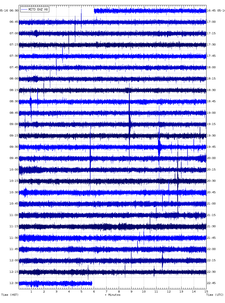
This station MITD further down the SWRZ connector also shows the same tremor as at RIMD, and looking at the longer term view over the past 2 days the daily variability and patterns are clear and much less intense than the ongoing tremor
 ?fileTS=1713522457
I dont think a dike is forming now, but magma is flowing down the connector again. The last intrusion was 30 million m3 and ended 77 days ago, so more or less since then has been about 350,000-375,000 m3 of magma per day or 4-5 m3/s, which is pretty much the same as before. Seems unlikely to me that the SWRZ doesnt erupt eventually unless the ERZ can open down to past Pu’u O’o in the very near future.
OTLD not OUTD 🙂
I see winds in the general area blowing from NE at 15kts sustained and gusts from 24 to 43 kts in the general area of Hawaii National park. They could be shaking the instruments around.
Mac
I dont recall weather ever being that visible on the Hawaiian instruments, and if it was strong wind then all of the seismometers would be affected but only SDH, MITD and RIMD show it, mostly the last two, and all are the close to the SWRZ connector. The stations in the caldera might show it but are mostly drowned out by daily fluctuations, while the stations outside the general area are completely unaffected.
If they were volcanic signals, they would show the same in different seismometers, with different amplitudes but the same shape. I think it’s more likely to be wind than tremor. Most tremor-like signals tend to be noise either weather or anthropogenic. The Pahala tremors or the Kilauea LP earthquakes do show up identically in multiple stations (also located by HVO) and those are volcanic signals.
Last eruption at Ruang emitted 0.5 Tg of SO2.
https://twitter.com/airesEO/status/1780839755011518889
For comparison the 2002 eruption (according to volcanodiscovery) emitted 0.1 Tg of SO2.
https://www.volcanodiscovery.com/it/ruang/news/239499/Ruang-volcano-Sulawesi-Sangihe-Islands-Indonesia-alert-level-raised-to-level-IV-massive-umbrella-clo.html
In Global Volcanism Program the 2002 eruption is listed as VEI 4 and it’s the only VEI 4 from this volcano. Last eruption is probably the largest one in recorded history.
Thanks. That’s a lot of SO2, similar to other VEI 4 eruptions, I think.
For comparison, Calbuco 2015 was 0.3-0.4 Tg, so Ruang is definitely a mid-VEI 4. Could be the second-largest explosive eruption since Kelud 2014.
Tilt at UWE (month’s worth)
RIMD seismiogaph (48 hours worth)
IKI tiltmeter (month’s worth)
HAT seismograph (48 hours worth)
These are the graphs that show some sort of activity at Kīlauea now. Now, it could be wind or business as usual, but something odd, like Chad suggested, could be going on here.
SDH tiltmeter (month’s worth)
UWB seismograph (48 hours worth)
SDH seismograph (48 hours worth)
The other stations show little or no signs (as of yet) on Kīlauea. I have checked other stations at the caldera, but either broken or too long of a span to see a signal (I.e. GPS for 2 years). I think this is all but there is a chance I might’ve missed a few.
I think it is magma flowing down the SWRZ connector, so it is kind of an intrusion but not a dike like happened at the end of January. But then, that dike did start after a couple of days of activity very similar to the ongoing swarm.
If a dike doesstart though the quake count will go from the standard 100-150 a day to 1000 in the span of a day or two, it will be obvious, but at the same time Kilauea gives only very short warning when it erupts, the 2020 eruption happened so suddenly HVO had to change the colour code immediately to red off of green. Kilauea might actually give even less warning of its summit eruptions than Hekla does…
WRM seismograph (48 hours worth)
Missed one.
Uncertainty is increasing in Sundhnukur area. Svartsengi’s reservoir has received 6 Mio cubic meters of magma since 16 March. “In previous events, magma has propagated from Svartsengi when between 8 and 13 million m3 has been added to the reservoir since last event.”
https://en.vedur.is/about-imo/news/volcanic-unrest-grindavik
The current volume of intruded magma:
We’re repeating the situation during the dormant days between Svartsengi I-III from December to February. But this time the volcano is not totally dormant, but still erupts at low level with 3 m³/sec. Why doesn’t the magma take the established path to the current eruption location? Does the magmatic intrusion happen in a different magma pocket than the source of the eruption?
Maybe the sill has several magma cave chambers which can be sources for eruptions. The present eruption receives magma from one chamber, but it can’t take magma from others. Does the sill traffic go like a one-way-street in several chambers? Maybe the magmatic pressure prohibits the movement of magma from one cave chamber into another one.
This is the best photo I have seen so far of the aftermath of the explosion at Ruang Volcano –
Speaking of which, GeologyHub posted a new video about it this evening. In which he mentions that the submarine vent that erupted was odd and that there were volcanic tremors occurring on the neighbouring island. Which he hypothesises that there could be a caldera and that Ruang forms part of a ring fault.
https://youtu.be/XumgBc4tJBo?si=Ji6EJKV4leL1mxf_
Thank you for the post. The NASA Firms satellite also shows that the 2nd island north of Ruang, the Volcano Karangatang is active today with heat signatures. See https://firms.modaps.eosdis.nasa.gov/map/#d:24hrs;@-233.7,2.6,8.4z
Very interesting, I’m looking at google earth history and you can kind of see a ridge north of Ruang but it’s difficult to make out (and could just be imagery. It does look as though the central underwater vent has been present before.
Definitely need some kind of underwater mapping here.
It is awfully close to the neighboring island. Would be interesting to see the bathymetry.
Both the LFI and MBL ConeCams(tm) have been nonfunctional for 24 hours. Does anyone know of any still-working ones with a good view of the cone and the perched pond just to its south?
No. But the tremor has dropped.
Source:
Probably just the workers taking the weekend off. The blue line has had dips down to the current level at regular intervals = short break between shifts. It’s gradually getting lower, but it is masked by work activity.
New post is up! Tallis between poker and patience
https://www.volcanocafe.org/joker-and-ace/