Iwo Jima has long been of particular interest to VC. It is an enigmatic volcano with a very human history. One of the pivotal battles of the second world war took place here, at immense human cost which arguably changed the way the war ended. The island remains home to the Japanese navy, and visits are restricted to those coming for memorials – of both sides. The people who visit find many reminders of the past. But in spite of the memories, the island has changed. The beach where the US marines first landed is now more than 10 meters above sea level. The island is also larger than it used to be. The volcano below is stirring.
Early September there was a report of increasing earthquake activity, which was followed by a minor eruption on September 12. It happened just off the south coast, and witnesses reported seeing water fountaining 10 meters high. But no pictures have emerged of the eruption, and after the event things quickly calmed down again. In itself, this was a normal event. Iwo Jima has such minor explosions every few years, sometimes on land, sometimes off the coast, although they have become much more frequent over the last decade.

We have found one (and only one) image which caught the effect of the eruption. A SkySat satellite photographed half the island on Sept 13. It uncovered strong discolouration in the water, on the south side of the island, in the general region where the fountaining was said to have occurred. Older images show nothing similar in this location, and it is likely volcanic ejecta. But the exact location of the outburst is not clear from the image: it will be either inside the coloured patch or just to the right in the region that was missed.
This post aims to bring together what is known about Iwo Jima, which perhaps is less than we should know. It is an extraordinary place, where the long-term inflation is among the largest seen anywhere in the world. The inflation is clearly volcanic: since 1889, 45 separate eruptions have been recorded. It deserves a closer look.
History
But first some background. The Volcano Islands (Kazan-rettō in Japanese) are a group of three small volcanic islands,of which Iwo Jima is the middle one. North of it is Kita-Iō (San Alexander Island), and south of it Minami-Iō (San Augustino Island).

Iwo Jima was (probably) discovered by the Spanish sailor Bernardo de la Torre, in 1543. On September 25, ‘they had sight of certain islands which they named Mal abrigos [‘bad anchorage’]. Beyond them they discovered Las Dos Hermanos (Two Sisters). And beyond them they also saw four [or three] islands more which they called Los Volcanes’. (Edited from Thomas Suarez, early mapping of the Pacific, 2013. For a more detailed report of the expedition, see the bottom of this post.) The first two islands are believed to be the Daito islands, and the last four or three islands are assumed to include Iwo Jima. Various sources state that he landed on Iwo Jima and named it Sufre (or sulfur) Island, but this appears not to be true: no landing is mentioned and the name was given by Cook’s expedition, two centuries later. In either case, the name has stuck: ‘iwo’ is sulfur, and ‘jima’ is island. (There are a number of ‘sulfur islands’ with a similar name, and it is not uncommon that an image of the wrong island accompanies a report on Iwo Jima. Anything showing a smoking volcano should immediately be discarded.) The official name was changed in 2007 to Ioto, and this should reduce the confusion. The new name has the same Japanese characters and meaning, but a different pronunciation and it is argued to be more historically correct. It will be hard though to remove the name Iwo Jima from memory. Too much has happened here under that label.
Captain James Kirk Cook is reported to have investigated the island in 1779. His journal contains a rather discouraging description of the (re-)discovery of the island:
‘Between 9 & 10 o’clock we passed by the island within a mile from the shore, and as it appeared to be barren and uninhabited we kept on our course without making any stay on it. At the southwest point of it stands a round hummock which appeared to be a volcano as we saw some brimstone on it; at the north east point stood a number of remarkable rocks close to the beach not unlike in their appearance to Stonehenge; the island is about 6 or 7 leagues in circumference & the land low & much of it covered with low shrubbery but no trees of any kind. ‘
A remarkable detail is that this was on 15 November 1779, which is 9 months after Cook had died; there must be some doubt about his involvement! This discovery from beyond the grave was in fact done by James King and John Gore, who had taken joint charge of the expedition. The discoverers were sailing north to south, so the fact that they picked out the southwestern point as the notable feature means it really stood out. The expedition did not land on the island, in contrast to what is claimed on wikipedia. The journal states that Iwo Jima is one of three islands they saw. De La Torre may have seen four.
The journal of Cook’s voyages (authored by William Bligh & James Cook) contains drawings of the island. They show the view towards the east-northeast. The ‘hummock’ dominates, with a low neck and a rocky dome. At the far end there are some rock plugs on a small dome, only just above sea level, with presumably formed the ‘Stonehenge’ feature he refers to.

http://www.davidrumsey.com/maps870154-24140.html (cc-by-nc-sa 2.0)
The map of the island shows the thin neck, the two high areas, and the surrounding shallows. It also indicates three areas further from the coast which presumably are rock reefs.

The basic features that Cook found still exist. They have acquired names since. The southwest ‘hummock’ is called Suribachiyama (or Mount Suribachi). The round dome is Motoyama, and the sandy neck in between is called Chidorigahara.
The risen land
But even though those features are still there, much has changed. On Cook’s profile of the island, Suribachiyama stands around 2.5 times higher than the highest point of Motoyama, and Chidorigahara is only just above the water line.
The recent situation is shown below, using profiles re-published by Kenneth LaJoie, in 1986. They show Motoyama almost as high as Suribachi, and Chidorigahara 40 meters above sea. Surabachi is currently about 160 meters tall. If it was this high also in Cook’s days, the old map suggests that at that time Motoyama was 60-70 meters tall. Nowadays it rises to 120 meters. Chidorigahara has gone from near-zero to 40 meters above sea. The conclusion is that much of the island has risen by 40-60 meters since 1779, where Motoyama has probably risen a bit more than Chidorigahara.

Source: Kenneth R.LaJoie, Coastal Tectonics (1986, published in “Active Tectonics: Impact on Society”.
The recent data shows the beach lines of the past. The one labeled ‘1779’ is suggested to be the beach seen by Cook, assuming that Motoyama and Chidorigahara have risen by the same amount (in reality, Motoyama is likely to have risen more). The line labeled ‘0.5-0.7 ka’ is for a layer which contains carbon-dated coral. Clearly, this layer was below water when the coral formed, somewhere around 1450+-100 AD. Nowadays, it is 100 meters above water. But the entire top of Motoyama shows coral fragments and rounded pebbles, showing it was entirely under water until quite recently.
So Motoyama has been coming up at an average rate of 20 cm per year, over at least 500 years! If Bernardo de la Torre did indeed see the same island, it must have looked a very different place, with Suribachi and Motoyama forming two separate islands. Perhaps this is why he may have reported four islands where later explorers found three (but see the bottom of the post).
Growing up

Iwo Jima. August 2018
The island has not only grown up. It has also grown out. The most current image comes from a satellite view obtained in August 2018. I have attempted to put the old map of Cook on top of the current view. This was done by assuming that Suribachi and Motoyama haven’t moved, and using these to align the two images. The overlay may not be perfect!
The comparison shows how much Chidorigahara has widened. Much of the dotted parts of the old map, indicating shallows, are now land. The east and west side of Motoyama have especially grown. The northeast coast, where the old ‘Stonehenge’ must have been located, has not moved as much. The coast here is quite steep.

The rock reefs are an interesting problem. One of the reefs on Cook’s maps, Kamaiwa, has become incorporated in the beach (this happened around 1968). His two other reefs have disappeared. Two new features have taken their place. On the west, there is a new island (called Kangoki-iwa) which is close to merging with the main island, and on the east side there is a new reef (Higashi-iwa) where the rocks come up to just above the water line. It is a little suspicious that two reefs have gone missing while two new ones have come up. It is possible that both were misplaced on the map.

The rocks of Higashi-iwa
The growth of the island has been followed now for over a century. Below are a series of maps compiled by Norio Oyagi and Takashi Inokuchi, and published in Geology of Iwo Jima. The maps depict the changes between 1911 and 1983. Until 1952, the coast line was fairly stable, apart from a slight extension on the west side. After 1952, growth took off. The changes on the west became spectacular. Cook’s old reef which since had acquired the name of Kamaiwa used to be 1 kilometer off the coast. The channel between it and the coast was 36meter deep and navigable. After 1952, the beach extended into the channel by as much as 50 meters per year, and in 1968, Kamaiwa became connected to the coast. Beyond it lies the island of Kangoki-iwa. It used to be more than 1.5 kilometers from the coast, far enough that it was used to house prisoners. The shark infested waters provided an escape proof barrier. By 1983 Kamaiwa formed the closest part of the coast. The beach has continued to grow since, and in the 2018 image above, is only a few hundred meters from Kangoki-iwa. Escape finally beckons for the prisoners, albeit too late to be of any use.

Why did the beach extend so quickly and by so much? This was more than just uplift. It turns out that it was related to the uplift of the coast to the north. The steep coast line here eroded while it was uplifted, perhaps hastened by the regular typhoons (several pass though here each year). The eroded sand was moved by the current and waves, and deposited on the west side. Sometimes the sea just can’t win. But it does try.

This image (from iwojima.com) shows the typical lineation of raised beaches. Look above the cliff, and the lineation continues in the rocks, suggestive of earlier periods of wave erosion.
Activity
Iwo Jima is doing more than just grow up and grow out. It is also frequently volcanically active. The eruptions are small, short-lived explosions, and come from a number of different locations. The same location can erupt again, even after decades. Interestingly, although the activity is centered on Motoyama, the outbursts are rarely there. They seem to follow the edge of the dome. But some eruptions have happened on Motoyama itself, in particular in December 2016 and in late 1969. The larger explosions can leave holes tens of meters deep and wide.
Fumarole activity is widespread, mainly from the crater on Suribachiyama and its steep western slope, and from the northern part of the island. The fumaroles deposit sulphur which was commercially mined until the war. At the top of Motoyama there are even some boiling mud pits. The vents move around, old ones go extinct and new ones appear.

On the map above, from Ueda et al., 2018, the numbered circles indicate the known locations of eruptions since 1890. The most frequently erupting location is ‘1’, with 13 outbursts, and ‘7’ with 10. These two locations are next to each other.
The 12 September 2018 eruption is close to location ‘10’ which previously erupted in 2001. It is a repeat offender.
The map also indicates four seismic stations. One, 0605, is located at Suribachi; the others are at and around Motoyami. They have provided continuous GPS measurements since the late 1990’s. Before that, measurements were taken every two years. Between 1980 and 2000, the GPS data showed relative little change: the rapid changes in the 1950’s and 60’s had given way to a quiet few decades. But after 2000, renewed uplift began to show, and since 2010 it has accelerated further. This was accompanied by increasing earthquake activity. Suribachi remained relatively unaffected, with minor uplift beginning to show only in the last few years. But the movement near Motoyami has been extreme.
Station 0604 has risen by 5.5 meters since 2000, most of which happened after 2011. Not many volcanoes in the world have shown such large movements! This continued from the pre-1980 events: between 1920 and 1980, the maximum uplift on the island was 11 meters. The peak at that time was north and west of Motoyama, while Motoyami itself rose by 6 meters. This time, the uplift seems centred on the south side.

Volcanic activity also accelerated. Over the past 7 years, there have been 20 separate volcanic explosions. During the 7 years before that, there was only a single event, in December 2007. There is more here than meets the eye: there are developments below ground.
Below the water
Iwo Jima forms the top of a strato-volcano. Remove the sea, and a large mountain appears, 2 km tall and 40 km across.
The plots below (from Sohei Kaizuka, 1992, Quaternary International, Vol. 15/16, pp. 7-16, 1992) show the detailed bathymetry, Iwo Jima is surrounded by a smooth under-water plateau at a depth of some 15 meters. At the outer edge of the plateau, there is a drop to a depth of about 100 meters, followed by a patchy rise which in a few places sticks out above the water. Outside of this rim, the mountain steeply falls to the sea floor, 1500-2000 meters below. It is a sizable volcano!


The patchy rim runs roughly from Kaimawa and the island of Kangoku-iwa, around the north side, to Higashi-iwa, 2 kilometers off the east coast. The rim is about 1 km wide. This is wider than Kangoku-iwa: there are four rocks which just break sea level a few hundred meters on the seaward side of the small island, which also are located on this rim. Two of these are visible as white spots on the August 2018 image above, west and northwest of Kangoku-iwa. On the north side, the raised rim is located some 100 meter below sea level. But to the south, the plateau ends with a sharp fall, without a clear raised rim. The profiles shown above have rims at positions A, B, D and F, but there is no indication at positions C and E.
The rim is argued to form a 10-km wide caldera. Iwo Jima and its plateau covers much of the caldera; Motoyama is near the centre. But the classification as a caldera may not be fully certain. The raised rim only extends halfway around the island, with Suribachi placed outside it.
The inner part is unusually shallow for a caldera. But this flat top, 10-km wide, on a mountain 40-km wide, unusual for a volcano, makes sense from the point of view of wave erosion. This has kept removing the top, down to the depth where waves can reach, some 15-20 meters. A caldera would imply a massive explosion removing the entire top of the stratovolcano down to exactly sea level. Erosion can do the same thing, but takes longer.
The rim has had volcanic activity. Kongaku-iwa consists of lava. Higashi-iwa looks like a volcanic cone, similar to Suribachi. Suribachi itself is just outside the rim. But the volcanic outbursts over the past century have been minor crater-forming explosions, rather than cone building, and have taken place on the plateau and the island, and not on the rim. Clearly Iwo Jima can do much more than what we have seen in recent years.
History
In fact, the island has in the past blown its top, and it has done so more than once. The evidence is everywhere. Motoyama is covered by pyroclastic deposits. Suribachi has its own pyroclastic layer, with some lava. Kangoku-iwa consists of lava. Bore holes at Motoyama going 150 meters have found alternating layers of lava and pyroclastic deposits. This adds a warning from history to the on-going inflation. It would be useful to know the full volcanic history of Iwo Jima.

Geological map, Ueda et al. 2018. The map shows the various parts of the island, with the local names. The colours indicate various deposits, including pyroclastics and some lava.
Pyroclastic deposits surround both Motoyama and Suribachi, but they form separate layers and do not come from the same eruption. It appears that Motoyama erupted first. Carbon dating has been done on the lowest layer of ignimbrite and on the rocks of Kaiwama beach. Lava is itself of course not date-able: the carbon is obtained from whatever organism was buried by it. At Kaiwama these were shells, which were dated to 131+-20BC and 31+-20 BC. At Motoyama, interestingly, it was carbonized wood and twigs, dated to 761+-20BC and 762+-20BC. This means that Motoyama, at the time of the major explosion, was partly above water and was forested.

The depiction above is from Nagai and Kobayashi 2014, https://www.jstage.jst.go.jp/article/jgeography/124/1/124_124.65/_pdf/-char/ja Around 2700 BP, this forested island was destroyed by an explosion. The island disappeared below water, were the ignimbrite rained down. Next, lava came and build up a new dome, but it remained submerged. The lava had an unusual composition called trachyandesitic. More eruptions followed, with layers of pyroclastics. How long this lasted is not known. Based on the carbon dates of the shells, it may have continued for over 500 years. It left a yellow, soft tuff, used in the war to dig shelters.
Suribachi formed afterwards, but how much later is not really known. It existed in the time of Cook, and probably also in 1543, and must therefore have formed earlier. That still leaves us a 2000 year window. Trachytic magma was erupted at Suribachi three times, first as marine pyroclastic eruption, second effusive in shallow water, and finally form a pyroclastic cone on land.

Now the third phase started, where Motoyama calmed down but inflated, at an average rate of 20 centimeter per year. Precisely when the inflation started is not known. At has lasted at least 1000 years, but may also have begun shortly after the Motoyama eruption. And it is still continuing, with frequent volcanic activity. The fact that the top of Motoyama is littered with old coral shows that there was no lava associated with the rise. It was pushed up from below, not build up from above.
In this history, Motoyama is the sum of the 2700-2100 BP eruptions pushed up by the subsequent inflation. The under-water plateau surrounding the island may be the result of the volcanic ejecta, less affected by inflation and continuously decapitated by the waves. Suribachi is a separate eruption, perhaps 1000 years ago, perhaps older.
What about the caldera rim? If this is a caldera, it existed already before the eruption at 2700 BC. There must have been a massive eruption, but all we can say is that it was earlier than 2700 BC. There is no evidence for this other than the partial ring. However, there is another layer of lava underneath the Motoyama lava, called the Hanareiwa lava, and this shows that there were earlier eruptions. The age is unknown.
Seismology indicates that below the Hanareiwa lava is another lava layer. Together, the three layers are 200 meters thick. Between 200 and 500 meter deep is a high velocity layer, presumed to be tuff. This must be from an even older eruption and perhaps this was the caldera forming eruption. Below this is even more lava.

Pyroclastics in a Motoyama cliff face, surrounding a large tuffaceous block
Magma on the move
But what is causing this extreme, long lasting inflation? Intermittent inflation and deflation in large calderas is common, and normally caused by moving hydrothermal water. But the inflation at Iwo Jima is far too large for that. It is caused by accumulating magma. The geodesic measurements show that there are shallow sills underneath Motoyama. They grow, erupt and deflate, pushing the summit of Motoyama up and let it come down again. But at the same time a much larger area is continuing to inflate. That indicates a deeper, and growing, magma reservoir.
And what is causing the eruptions? They are phreatic, meaning caused by water. It appears that there is water inside the deep tuff layer, 200-500 meter under ground. Rising heat brings pockets of this water to the boil, but it can’t get out because of the seal of solid lava above. The lava is pushed up but the agitated water, causing rapid inflation and earthquakes at ground level. After a few days a crack develops in the lava seal. Now we get a sudden explosion, as happened on 12 September this year. The eruptions are primarily in the region where the rise of the central region has caused faults, around Motoyama but within the caldera rim. Two such faults became active shortly after the war.
So where is the magma? The shallow sills are thought to be 800 meter to 1 kilometer deep. It is fed from a deeper magma chamber, where the main inflation occurs. A pulse of magma into the deep chambers brings with it heat, which percolates up into the tuff water. Phreatic eruptions follow. Iwo Jima is currently in such a phase.
Future history
In the long term, Iwo Jima seems to repeat itself. The inflation will continue, but eventually a major eruption will break through and destroy the island. Pyroclastics and lava will build a new dome. After a few hundred years, the eruptions cease. Inflation resumes and over time the island reforms. Until the next eruption.
Where are we in the cycle of Iwo Jima? That is not easy to know. However, it is unlikely that the island was much larger than it is now, at the time of the 2700 BC eruption. The build up to the next one is well under way. But when exactly is impossible to say. How large would the eruption be? We can make a maximum guess by assuming that a 100 meter high island, 23 km2 in size, is replaced by a 200-meter deep hole. That suggest something in the range 5-10 km3. This the DRE value: the tephra will be several times larger. At the top end, a Krakatoa-size eruption might be possible.
But volcanoes do not like being predictable. Sometime before 2700 BP, perhaps long before, it may have done a significantly larger eruption. Just to keep us on our toes.
Iwo Jima has played a part in shaping the post war world. The memories of that event run deep and have left scars, but scars are also signs of healing. We should not forget what happened here, but it belongs in the past. While Iwo Jima keeps rising, the volcanic heritage will become more and more important. One day, it will happen again.
Albert, October 2018
Recent papers on Iwo Jima, extensively used for this post:
Volcanic History of Ogasawara Ioto(Iwo-jima), Izu-Bonin Arc, Japan Masashi Nagai* and Tetsuo Kobayashi, 2015, Journal of Geography(Chigaku Zasshi), 124, 65–99 (with many images of rocks formations on the island)
Phreatic eruptions and deformationof Ioto Island (Iwo-jima), Japan, triggered by deep magma injection, Hideki Ueda*, Masashi Nagai and Toshikazu Tanada, 2018, Earth, Planets and Space, 70, 38

source: Nagai and Kobayashi, 2015
Appendix: The discovery of Iwo Jima
In 1542, Ruy Lo´pez de Villalobos sailed a Spanish expedition from Mexico to the Philippines. After arrival, and meeting a mixed reception from the locals, Bernardo De La Torre was tasked to find a route back, taking one ship from the six of the expedition: San Juan de Letra´n, in order to ask for reinforcements. This task failed: the first successful eastward crossing of the Pacific happened only in 1565. De La Torre sailed a route roughly north/northeast, reaching 30 degree north and finding a number of new islands, but eventually was forced back by storm and lack of water. The chronicles of his journey appear to be lost, but the trip is mentioned in several documents from the 1540’s and 1550’s. These reports are second-hand and in some places are contradictory. The most likely actual journey was pieced together by Bernhard Welsch, in 2004, and I am following his arguments here.
De La Torre departed from the central Philippines on 26 August 1543 (the dates in use at that time were the Julian calendar. The Gregorian calendar was not adopted until 1582). He sailed east for a few days before turning north, eventually crossing the tropic of cancer. (Typically, reported latitudes are reliable, but longitude could not yet be measured.) Several islands and groups of islands were discovered on this leg, before he was forced to turn back.
On 25 September 1543 they sighted a small island at 26°N which they called Mal abrigo (bad anchorage) because the sea was breaking against it. They sighted two more islands 26 leagues further which they called Duas yrmaas (Las dos hermanas, meaning The two sisters), but didn’t land there. (A spanish nautical league at this time was not perfectly defined, but in practice there were about 15 leagues to a degree, so 26 leagues was a bit less than 2 degrees.) Later they saw three (one of the reports says four) more islands, at 24 and 25°N. One of these was volcanic with fire in three places. These islands were called Balcones (Volcanoes).
On 2 October 1543, they sighted an island they called Forfana (the orphan), beyond which there was a high mountain or rock, with fire at five places. But the story here appears confused, because the description ‘fire at five places’ sound very similar to the previous ‘fire at three places’. The first is reported in one of the second-hand sources, and the second in another. It seems likely the two sources were reporting the same observation, but attributed this to different islands. In reality, only one active volcano was seen.
On 18 October 1543, between 29° and 30°N, after hitting a northerly storm, they became worried about their supply of drinking water. They turned around and after 13 days arrived back at the departure point. On the way back, they came across some smaller islands ranging in a north–south direction from the 15th to the 16th degree N latitude, which were the Ladrones (the Marianas), but they did not anchor there.
So which islands did they find? The first ones, Mal abrigo and Los Dos Hermanos, are accepted to be the Daito islands. Mal abrigo appears to be Oki Daito, 24.5°N and surrounded by coral reefs, and the two sisters are Minami-Daito and Kita Daito, about 1.5 degree due north of Oki Daito and less than 10 km apart. One of the old but second-hand reports places the first island at 16°N, and this is therefore often identified with Farallon, but this appears unlikely: the Daito islands, 10 degrees further north, fit much better with the descriptions.
The three ‘Volcano’ islands are identified with the Kazan Retto group, 10 degrees due east of the Daito islands; Iwo Jima is the middle one of the three islands of this group, and it is located at 24.8°N. That identification was first suggested in 1803 by Burney, a member of the Cook expedition. Burney wrote :
‘it will appear very probable, that the Sulphur Island, with the North and South Islands, seen by the Resolution in her return from the last voyage of Captain Cook, are the islands which were called the Volcanes, discovered by the San Juan. Their agreement in number, their spreading nearly a degree in latitude, and in the same parallels, and their appearance so well corresponding to the name, form a combination of circumstances that amount to very little short of conviction.’
The next island that was discovered was called ‘Forfana’, and is said to be an uninhabited island 30 leagues (150-200 km) from ‘Volcanes’. It was sighted on 2 October 1543. The direction is somewhat problematic. One source says it was east to northeast from the Volcanes, where only empty ocean exists. But this source also states that the second Daito island discovered is northeast of the first, while in reality it lies due north. If the same mistake was made here, the final island really lies in a north-northeasterly direction. And there are islands there: the southernmost part of the Osagawara archipelago, where the nearest island is 150 km from the Volcano Islands. This makes ‘Forfana’ to be Hahajima, the southernmost of the major islands, or one of the small islands which surround it at 2-3 km away. This fits well with the description of an ‘orphan’ (Forfana) beyond which was a high mountain. The highest mountain on Hahajima is over 400 meters.
The route from the Daito islands to Iwo Jima and on to Hahjima is not straight. It runs a bit south, and turns northward. If De la Torre passed through the Iwo Jima groups east-west, he could well have missed either the southern or northern island of the group. If Iwo Jima consisted of two separate islands at the time, as seems likely, it is perhaps possible that of the three Volcano islands he saw, Iwo Jima accounted for two. But this is speculative and mainly illustrates the uncertainties around the story.
After Hahajima, De La Torre sailed on for two more weeks into the open ocean, but eventually was forced to turn around, found Vila Lobos gone, and finally met up with the expedition around the Moluccas (not far from Sulawesi) in early 1544.
There are some lessons from this story. The San Juan was nowhere near where the sailors thought it was. It sailed a complex route, first east, than due north, east-southeast again, and finally north-northeast, putting the ship far to the west of where it though it was going. If you can’t measure longitude, the course can be a bit of a guess. Some of the deviations can be explained by tacking against a predominantly northeasterly wind, and others by the effect of the west-flowing north equatorial current, which becomes the northeast-flowing Kuroshio current in the region of the journey of De La Torre. Some may have been deliberate. He may have been aiming to catch the returning North Pacific current across the Pacific, at 30N, and therefore trying to gain latitude before turning east. Or he may have been deliberately looking for islands, in order to obtain water. We can only guess.
We have further learned that Iwo Jima was discovered after 25 Sept but before 2 Oct 1543 (Julian dates). Often, the first date is given, but that is for the Daito Islands. Looking at the distances involved, the most likely discovery date is 30 September 1543. We have found that the name ‘Sulphur Island’ comes from the Cook expedition: De La Torre’s name for the islands was just ‘Volcanes’. What we do not know is what Iwo Jima looked like, however as it was clearly labeled as ‘volcano’, the peak of Suribachi must have existed, as this is the only obvious volcanic feature seen from a distance.
That fire-belching volcano
There is one final point to solve. What was that erupting volcano that so impressed the sailors that two second-hand accounts tell the story, albeit attributed to different islands? One account places it at the Forfana group, i.e. the eruption was at or near Hahajima. This group of islands is indeed of volcanic origin, but far from recent. The eruptions were several million years ago, the chain has gone quiet and the eruptions are nowadays at a separate chain of islands further west, where for instance Nishinoshima is located. In spite of the statement placing ‘a high mountain or rock, which was belching forth fire at five places‘ at Forfana, this event cannot have been here.
The other account places it at the Volcano islands: ‘‘they sighted three more islands; one being a volcano belching fire at three places’. This narrows it down to one of three possible islands. Assuming both accounts are for the same event, we are looking for a high mountain with multiple eruption sites.
The three Volcano islands are, from north to south, North Iwo Jima (Kita-ioto), Iwo Jima (Ioto), and South Iwo Jima (Minami-ioto): together they make up the Kazan Retto group. The southern island is a single, 900-meter tall cone, about 2-km wide at sea level. There was a marine eruption a few kilometers off the coast in 2005, where lava floated to the surface. The northern island, Kita-ioto is larger but slightly less tall, at 800 meters: it appears more eroded. The summit of Kita-ioto is extinct, but there have been several eruptions off the coast over the past two centuries. Neither island is known to have had historical activity on the main mountain on-land. But the description clearly refers to an eruption on land. Although neither can be excluded, given that Iwo Jima itself is known to erupt on-land, it is a likely candidate for the erupting mountain.
But Iwo Jima also shows little or no evidence for recent lava. The most recent ‘fire’ eruption was probably the one which caused the top pyroclastic layer around Suribachiyama, and this could be as young as 1543. But the description gives no mention of explosive activity, just multiple fires. Phraetomagmatic explosions, similar to the current activity, can also be excluded, because it lacks associated light. Was the entire description made up, or greatly overstated?
There is an alternative. The crater of Suribachiyama, and other places on Iwo Jima, can show heavy fumarole activity. Looking at the dates and distances, De La Torre probably passed here around 30 September. Two days later, Oct 2 1543, was a full moon. Did he perhaps pass at night, and see very active fumaroles reflecting the light of the nearly full moon? That might have looked like fire to people unfamiliar with fumaroles, and it would explain the multiple locations where fire was seen. A night vision could even explain the confused reports about the actual location of the event.
So, event though the circumstances of its discovery are now clarified, the volcanic fire that so impressed the sailors remains a mystery. If only we could recover the lost chronicles of the discovery! Second-hand reports, even from within a few years of the events, leave too much unclear.
Main source: (2004) Was Marcus Island discovered by Bernardo de la Torre in 1543?, The
Journal of Pacific History, 39:1, 109-122, DOI: 10.1080/00223340410001684886


Iwo Jima volcano on 23 February 1945
2001 pheratomagmatic explosion in the beach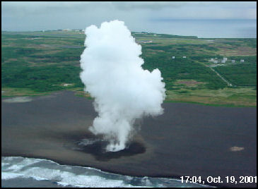
Likley magma rising into seawaterlogged sediments, the most recent eruption in 2018 took place just offshore
Pheratomagmatic burps on the Iwo Jima beaches 2001. Caused by magma rising into seawaterlogged sediments and groundwater
The most recent activity of Iwo Jima in 2018 took place just offshore and never broke the surface I think
The September 2018 eruption was indeed the reason to write this post. Water fountains of 5-10 meter high were seen but not photographed.
It would’ve been a whole other story if it had erupted during the battle!
Given the volume of explosives being expended during the battle, it’s surely possible that an isolated phreatic explosion would have been lost in the tumult
I think some of the eruptions might have actually been grenades or other explosives that were rusted through and exploded when raised above sea level and subject to gravity. Maybe the isolated ones are more likely to be these.
Discolored water from a submarine eruption in September 2001 surrounds Ioto, also known as Iwo-jima. The triangular, 8-km-long island, whose name means “Sulfur Island,” lies within a 9-km-wide submarine caldera and narrows toward its SW tip, where the Suribachiyama cone is located. The yellow arrow marks the site of the 2001 submarine vent. Ioto (Iwo-jima) has undergone dramatic uplift for at least the past 700 years accompanying resurgent doming of the caldera. Numerous historical phreatic eruptions have accompanied the remarkable uplift.
Photo by Nakahori, 2001 (Japan Meteorological Agency, published in the Bulletin of the Global Volcanism Network).
Another informative post by Albert…. so these are the ‘Japanese Islands’ so frequently mentioned in the earthquake reports on USGS….? ….
Just saw a news report from Panama City. The reporter, as typical, set up her shot to showcase the damage. Funny bit, I recognized the wooded area behind her. It’s maybe a half mile south of a Forestry office there. I realized then that it was probably fortuitous that the office is there. They usually have a few pieces of heavy equipment there for maintenance, so getting something up and running to clear roadways is probably quite easy if any of their personnel can get into the compound. Based on the video from the reporter, that seems to already be in play. (I’ve been in that compound doing IT work, so I know they do heavy equipment maintenance there)
Interesting read on mount Etna – gravitational collapse of southeastern flank: http://advances.sciencemag.org/content/4/10/eaat9700
Released from the spam-a-lot bin – Admin
Thanks for that! Found it very accessible for a dense person like myself. If the research raises awareness of the increased need to monitor that flank then it can only be a good thing. An awful lot of people live around the coast there.
This is something I noticed after looking at the locations on kilauea where fissures have been active since 1955. The area where the highway fissure formed this year was is right within an area that has a noticeable gap in the location of recent activity, just above Leilani. In going with the idea that such areas represent likely places to rift next, this is even more of a reason to watch this area closely, even if the deformation it is showing now is minor in comparison to eruptive deformation.
The pic above also shows the probably location of magma chambers within kilauea, some already known (halemaumau, makaopuhi, napau, mauna ulu, keanakako’i, south caldera) and some inferred (kilauea iki, pu’u o’o, heiheiahulu, kamakaia hills). almost all of these seem to have fed extended eruptions at some point in the past, most recently only earlier this year. Keanakako’i doesn’t seem to have formed on or directly near a persistent surface vent but is where the east rift is believed to interact with the summit. The orange is the deformation area where the ground change is beyond negligible, and showing inflation. It appears though the pu’u o’o and heiheiahulu magma chambers are being fed, more so the latter. The summit has shown a tiny bit of deflation so there is still a stable connection, and with that the potential for more long lived activity on the east rift. With no gas-release source now, the start of the next eruption might be quite impressive too, featuring the typical high fountains.
HVO now concludes too that the summit is sending magma into the ERZ and the deflation seems to be centered around the Southern caldera rim right now, though only if the slight slow drift of CRIM towards south can be considered significant enough, it would make sense since the Halema’uma’u reservoir should be no more by now.
I think at this point most of the inflation is from resupply, the inflation on the flank is more than the deflation at the summit, this is very interesting as it basically means this eruption in Leilani, as big as it was, is not a terminator event, the east rift is still active and openly connected to the summit. There might have to be a repeat of this years events at a lower altitude to fully finish things off and bring an end to this period of high rift activity.
This years eruption might be similar to the eruption that created pu’u honuaula near PGV, that eruption is apparently poorly dated despite being very accessible but happened somewhere between 1620 and 1750, probably around 1700. Its hard to tell exactly how big its flow actually was because a fair amount was buried before detailed observations, and now most of it is after the first stage of this years eruption, but the flows seem to be at least comparable to how big this years eruption was prior to the reactivation of fissure 8. The only big difference is that pu’u honuaula didn’t terminate a shield eruption like this did to pu’u o’o.
The pu’u honuaula eruption predates at least part of kapoho cone (there is a bit of evidence that cone formed through multiple eruptions in close proximity), as ash from kapoho cone covered a flow from pu’u honuaula in the former kapoho area. This area, mostly covered by lava from pu’u 8, is where I think the next big flow from kilauea will happen, a massive high volume almost flood basalt eruption similar to 1960 in that it starts off very intense but the overall eruption is much bigger, probably with high fountaining and significant ocean entry and possibly a large amount of phreatomagmatic or even submarine activity. Not something you would want to be around…
This could be preceded by summit activity or eruptions in the pu’u o’o – highway 130 area, but probably almost aseismic until it is under the general area of its eruption point, due to more open conduits to low elevation. The difference in elevation from this area to fissure 8 is about 350 meters, similar to the 400 meter difference between fissure 8 and pu’u o’o, and it is over 1 km below the summit, and if it goes just a bit further it would end up several hundred meters lower underwater. This would very likely finish the job started by this years eruption.
John and Phil have talked about the possibility of the summit collapsing passively from magma filling space created by continuing south flank movement. I think this is unlikely though as the movement is pretty small and can probably be countered by the supply rate. 6.9 is a big quake but this area can and has done much bigger and even that was not enough to collapse the summit, or even really stop it erupting for more than a few years. I think all that south sliding would do is make an even more open conduit and more available magma for a big eruption.
I see Hurricane Leslie (currently Category 1) will make landfall in Portugal, Lisbon, around midnight on Sunday. It’s forecast to lose it’s steam and drop to a Tropical Storm just before landfall. Looks like the area will have some bad weather. To add insult to injury the decayed remnants of Michael (the storm, not Michael Smith from No.15) will make landfall in the same area a day or so later.
Sorry that’s Saturday…
Yeah, landfall in few hours in Portugal. Not usual around here. Im spanish.
That’s right, the only other tropical cyclones to have made landfall on the Iberian Peninsula as far as I know were Vince in 2005 and the one in 1842, there was the close call with Ophelia last year. To me the current trend is of increasing risk of this events happening. I am in Cantabria right now, arrg, I am guessing this will feel as an ordinary cold front here.
Well, the storm should be fully extra-tropical by the time it gets there. So it really should feel no different than that. Usually they have an attached front by the time they make the conversion.
From the news this morning it looks like they took a pummelling with landfall just north of Lisbon. As expected it dropped from Cat 1 just offshore, but the resulting tropical / ex-tropical storm still ran a lot of Cat 1 wind speeds in places. The Portuguese Met Office seem to have been caught off guard?
There must have been enough warm water in the area to keep Leslie active. A couple of years back Ophelia maintained Cat 3 as it passed Biscay before dropping to Cat 1 mere hours before arriving in Ireland as ex-tropical depression.
The conclusion we could draw is for the time being the Atlantic is warmer than average in more northern latitudes. However, a couple of naughty hurricanes does not make a statistical trend, just an interesting bit of weather to watch.
Actually I take that back. The Portuguese Met Office and Civil Protection did have it all in hand.
They got beat up pretty bad in Panama City. News just announced that ATT is putting in a mobile cell tower to try and get rudementary cell service restored. Search/rescue operations still ongoing.
Gulf Power is still showing 85,140 customers off line and there are mobile charging stations set up at various point in Panama City for cell phones and such. Based on the outage map, it looks like most of Panama City is without power. Including Lynnhaven, Parker, Callaway, Bonifay, Chipley etc. From what I’ve seen of news coverage for Mexico Beach, there aren’t many buildings left to get power, but it is outside this maps service zone.
https://outagemap.gulfpower.com/external/default.html
Evidently, they have some sort of curfew in place. Stepson noted that he had to get out of Bay County by 1900 local or face arrest. (he’s been moving supplies in association with his jeep club)
Geothermal Vent communities; https://ocean.si.edu/ecosystems/deep-sea/microbes-keep-hydrothermal-vents-pumping
??
All I get is “secure connection failed”. There’s a “try again” button, but several clicks of it did nothing but generate the same message over and over again.
Hmmmm divers swimming above erupting Kavachi in 2002 look at the huge discoloured plume in the otherwise crystal clear water, not a smart thing to do. Fun to see that small cone already gone effusive and lava despite being so small. That cone was later washed away. I heard that sharks live inside this volcano.
Fools.. doing that. I wonder when this submarine volcano will form a permanent island
If you are trapped in the gas bubbles.. submarine eruption startup, you loose bounacy and sink towards the vent : D likley boiled first. I wonder how many hammerhead sharks thats been sinked so far
Shark-cano. This lava seems fluid enough to do lava balloons.. gas filled sacks that float to the surface
https://news.nationalgeographic.com/2017/04/sharks-underwater-volcano-sharkcano-kavachi/
I wonder if eveery caldera have sharks now…. lol
old but fun news
Taal had sharks in it until the 1930s
50 minute old film of the 1959-1960 kilauea eruptions.
https://www.youtube.com/watch?v=J9d7lcEYSuk&ab_channel=Yak18pilot
credit to Yak18pilot
Hold on … if it’s of an event that happened that long ago how can it be less than an hour old? 🙂
(And what is with this thing logging me out and now requiring my to input my name and email manually instead of filling it in automatically from gmail like it did before?)
This ended up in the ‘requiring approval queue?? The system seems to think you are new here.. – admin
Yes, something is evidently wrong with the system, and whatever it is happened in the past few days. It’s also not giving me the same avatar as before, even though I’m using the identical email and name!
Shark – canoes maybe there is deep sea sharks in Loihis caldera slowly robotinicly cricling around.. the crater walls. I imagines a shark vortex in there… everyone swims in a cricle … : D
Loihi sea mount had a 4, Mauna Loa added a few more quakes to the cluster.
2018-10-14 07:39:52 4 12.4
Small swarm close to Hekla. 6 quakes registered so far, all smaller than M1.
That’s roughly in the area where the 2000 run up went through.
And in the meantime, Vatnajökull is having some interesting activity as well. I count five quakes between 10-16 km depth at Öræfajökull, two deep ones at Unknownabunga, plus an M1.9 at Grímsvötn. I’d say the woolly mammoth race is on.
BTW, there are a few opportunistic scammers out there trying to profit off of the catastrophe in Panama City. Some are even politicians trying to scrounge donations for their re-elections and people for their mailing lists.
If you want to help, I recommend the Red Cross.
I’ve been in disaster situations before, and the Red Cross has always been a stand up group in my experience.
Reykjavik, this evenig, Island versus Switzerland: hopp, hop les suisses
lol
sorry, for the mistake: Iceland
not a mistake….. Iceland refers to it’s self as Island, doesn’t it?? Best!motsfo
My facebook is not working 🙁 I cannot reach my volcano friends
It refuses to accept my password on both computers and phones. Its been that for months now.
Not even when I have reset the password, it will work.. its stuck
Im worry I did not confirm that accout when I made it.. and erased that gmail sent from FB.
Im worry I made the account wrong.
I will never be able to reach my friends anymore, Im getting so worried and sad that I cannot breathe.
Im feeling alone… and Im sorry my emotions leaks out here.
VEI 9 eruption in bad feels.
i’m sympathetic; i’d really miss this site if i couldn’t get to it…. Can’t do anything to help You but i wish You well. Best!motsfo ps… if my adult daughter didn’t live with me i would have wrecked this computer a long time ago.
Thank you .. I feels so poorly
I should not talk about it here
At least you have the motivation to lament the FB issues. I avoid it like the plague. Always have, always will. If it blew away in a puff of dust, I’d be fine with that.
I niether Tweet nor Facebook for reasons i won’t go into
mainly due to old stalking issues from a female co-worker in
my old office..
Similar here. But, I do know that at least one that I was fearful of has since been prosecuted for unrelated matters. By my estimate, she should be out on parole by now. I don’t need any part of that.
Frame “e” of the formation sequence…. what is “hot stare” magma? Typo?
Hawaii is likley earths most powerful hotspot
Imagine if we place the Hawaiian hotspot… under the worlds fastest spreading oceanic ridge the EPR
that one spreads 11 times faster than Iceland I think
The results woud be spectacular
Sorty, all I can think of is EPR-EDP by Grendel.
I’m was suspecting a big discusion about the event at hekla this past day. One 2.2 and a a few one following it
With Hekla there isn’t much to say. She doens’t give much in the way of leading indicators that it’s “go time.” It’s basically crack→boom.
However from what I understand, the instrumentation at Hekla is much more dense than it was in the past.
As an update on Hawaii since the three most active volcanoes are under slight unrest:
KILAUEA: The LERZ continues to inflate between Pu’u’o’o and Highway 130. There have been some deep quakes lately, today a 37 km deep magnitude 2, 4 of the 6 deeper than 20 km happening since the end of the Leilani eruption have taken place during the past 8 days. Very shallow quakes continue at the summit and seismic activity in the south flank (interpreted as aftershocks of the 6.9). The Pahala swarm is much lower lately.
MAUNA LOA: Seismic activity continues at the summit and northwest flank but at lower levels than earlier this month. I am not sure how to interpret this but apparently there was a similar swarm in the northwestern flank preceding the 1984 eruption and the area was quiet in the decades that followed. That swarm is interpreted to reveal a failed rift structure in that area of Mauna Loa.
LOIHI: There has been a swarm at depths of ~10 km along the southern rift zone.
Also note the continuing collapse at Pu’u’O’o, which restarted a few weeks ago. This is the length across the crater
I have seen a viable explanation for this drop as being a slow sliding of the ground at that point, as the crater is very over steepened in its lower part (350 meters deep when first measured and that was with some infill of material), so it wouldn’t be surprising if it started collapsing passively.
That would be reasonable and would explain the contradictory data, if the area where PUOC is has started slumping into the newly formed crater which is quite possible then the distance between PUOC and JCUZ has shortened (the data of PUOC is not made public, only the distance to JCUZ). Other GPS of the area shows generalized uplift in the vertical component, probably from a deeper source than the shallow reservoir of Pu’u’o’o the JCUZ-PUOC graph was meant for.
This is the north/south movement, the station moved 30 cm south during the big quake, before sliding another 10 cm and then seemingly moving back that same 10 cm presumably from magma accumulation under the area.
The ground moved roughly on a 45 degree angle southward, falling about 30 cm down and south.
30 cm of space is quite small compared to the meters of 1975, and there is a big difference between 1975 and now. In 1975 all the recent eruptive activity was around the summit and upper rift, and the quake happened below that in the middle rift. This meant the magma moved down to a lower elevation, and maybe not coincidentally the 1977 eruption happened at about the end of this area. This year the quake happened in the same place but the main eruptive area was pu’u o’o which was right at the quake zone, and the big eruption was lower than the elevation of the quake. Unlike in 1975 there really isn’t much space to store magma where there wasn’t already magma, so I don’t think there will be very much of a delay to spend filling up the space. The tilt has also levelled off at almost all the stations, so the areas aren’t taking excess magma anymore and are pressurising again, particularly the heiheiahulu area.
Also the big quake drop should probably be ignored in the up/down section. The entire flank slid down, that won’t reverse. The gradual deflation afterwards can and has reversed, so effectively there is a magma chamber under there that has more magma in it than it did before, and that is important to watch.
Puu Oo is likley dead now… as dead as a icelandic lava shield is today
I will always miss the Puu Oo vent eruption edpisode.
KIlauea can do long lived eruptions. some slow kilauea and mauna loa lava lake feed tube eruptions from summits likley lasted many 100 s of years constantly.
its dead, never been souch a bad Puu Oo collpase drainage before
its as dead as a rock now. Soon Puu Oo flow field… will turn green
It will take years to cool, the 2014 pahoa flow is not cooled yet in its thickest parts
I expect.. that Kilauea Iki cooling magma body will forn nice columnar joints
It isn’t completely dead, at some point another eruption will happen within its crater, that might be a very long time from now or it might be within the next year but it will happen eventually. Who knows maybe another long lived eruption will happen in that area this century, maybe uprift between it and napau where a lot of eruptions have happened. Anywhere frequent intrusions have gone is a likely place for a new shield to form.
It will be interesting to see what pu’u o’o will look like in the late 21st century when I’m really old and looking at what will surely be a very different kilauea to now. It will probably be a bit more green than mauna ulu because pu’u o’o still has a lot of exposed tephra which plants grow really well in. Maybe the green tephra cone will appear sort of like a kipuka in the more barren solid lava.
Pu’u’o’o is in the rift zone, so yes, the area will eventually erupt again but for that to be considered as a Pu’u’o’o eruption is another thing. If you ask me these shields are monogenetic and can include more than one vent along a dike that is sustained for a certain period of time, at some point for some reason the dike will be abandoned and the eruption ends. Two sustained eruptions can overlapp but they are not necesarilly using the same conduit, the shields of Puu Huluhulu and Mauna Ulu partially overlapp but erupted from two different dikes that run parallel, same might be for the two shields at Heiheiahulu. A good example is Kane Nui o Hamo now completely dead and with no fissures that have opened at the summit crater since it erupted.
Shields formed centuries apart would be separate, but shields formed months or years apart would be fed from the same conduit in all likelihood. Kupaianaha was a separate structure to pu’u o’o when it formed but it was fed by the same system. This eventually broke down and vents uprift of the pu’u o’o scoria cone formed another shield. In 2007 the magma went downrift again, and formed a 3rd shield between kupaianaha and pu’u o’o. Then things again returned to pu’u o’o on the downrift side of the cone and now this year magma went downrift again but kept going. All of these are technically separate structures but all are fed from the same conduit. On top of that, most likely the conduit is the same as the one which fed mauna ulu, and now it is probable another shield is going to form even further downrift again in the heiheiahulu area, for a 3rd time. All of these could be considered one drawn out continued eruption as their feeder is the same. The small eruptions that have happened since February 1969 can also be considered to be part of this eruptive event for the same reason, as can the much bigger Leilani eruption this year.
What is interesting is how much bigger this past centuries rift event has been compared to previous cycles, but despite having the biggest eruption the caldera formed this year is the smallest.
1400s-1500 – 2 shields and 1 cone. Maybe 4 km3.
1600-1790 – 1 shield and 3 cones. About 5 km3.
1955-ongoing – 4 shields 6 cones. About 16 km3…
One of these things is not like the others one of these things just doesn’t belong…
You seem to have deleted the 1790-1955 epoch.. The fact that all of Puna was green forest already tells you that it had been little affected by eruptions for centuries. Adding the summit might change things, bit this is the basic idea of changing patterns. Over even longer times, though, I think the current phase is not unusual. And of course, going back to prehistoric times there are veyr large uncertainties on size of eruptions, what has been buried and lost, and what flows belong to the same event.
1790-1955 was not a period dominated by the east rift, except for 3 weeks in 1840. Prior to 1790 there was a lot of east rift activity, including a prolonged eruption like pu’u o’o although smaller. This period might have been as long as 200 years before that. The ~1500 caldera also seems to be roughly the same age as a big lava flow in the LERZ, as well as a shield mostly buried by heiheiahulu. This probably also lasted a few decades and started after the aila’au eruption ended.
This current episode is probably not over, but it has already erupted more lava than both the previous episodes combined, in less time than either of the others lasted on their own…
The number and size of the vent structures also indicates the size of this episode, pu’u o’o dwarfs anything else on the entire volcano, and this years eruption was probably the biggest lava flow in hawaii since it was first discovered, at least the 2nd biggest.
Self working with molecular biology and lots of artificial experimental systems to test hypothetical modells. I thought geoscience was more about collecting data from nature. How wrong I could be!! Found this article studying ricequakes in mixes of rice and milk. Very impressed indeed!! Tracking time with ricequakes in partially soaked brittle porous media
Itai Einav and François Guillard
DOI: 10.1126/sciadv.aat6961
Sci Adv 4 (10), eaat6961.
Edit Add: http://advances.sciencemag.org/content/4/10/eaat6961
Evidently, the focus of the work is geared towards finding an analogue to wetting in earthen/rock dam structures.
Was it an Ignobel contender? )
https://www.youtube.com/watch?v=v7SbCSaHKAI
Relaxing video
Maybe Pliny the Younger was wrong… or forgot to wind his calendar…
https://www.telegraph.co.uk/news/2018/10/16/newly-found-inscription-pompeii-rewrites-history-eruption-mt/?li_source=LI&li_medium=li-recommendation-widget
I saw an interesting comment on that article that made some kind of sense. Here’s what I quickly found.
Quote approx from Gurgle: The Roman Calendar had 10 months in a year of 304 days. (The Romans seem to have ignored the remaining 61 days, which fell in the middle of winter). The 10 months were named Martius, Aprilis, Maius, Junius, Quintilis, Sextilis, September, October, November, and December.
Now this calendar was reformed to the 12 month version long before Vesuvius, but October was called that because in the old calendar it was the “Eighth Month” and this name of course is still with us. (As did September, November and December – relate to the original position in the old calendar.)
So one could understand how Pliny’s description can be misinterpreted. Given the dating of fruits (olives and pomegranates, etc.,) and now the graffiti, we might now have the evidence to pin the date to the 24th day of the Eighth Month (Oct ober)?
The roman calendar started the year in march. This made october the eight month. The 10-month calendar was no longer in use at the time but the start of the year generally remained in march until the julian calendar was adopted.
https://www.youtube.com/watch?v=fmCJSS2YAP0
This video shws Holhuraun near peak strenght
Its quite impressive these giant fountains
The first Hawaiian eruption in Iceland since 1984
I discovered this site through watching videos on holuhraun around the time that particular video was made 🙂
The eruption in that video is how I thought the leilani eruption would look back when things started getting really intense in late May, massive cone formation with lava fountains in the 200-300 meter range, like 1960 on steroids. In a way it actually was that intense but the vent had eroded too much to have big fountains by the point it had its biggest surge (in mid July, when it nearly overflowed the entire cone). I think USGS was expecting some level of high fountaining too, but instead there was just a massive lava flood for a few months.
It is pretty incredible that in the space of only 5 years there have been two massive lava eruptions that both had a similar effect on their parent volcano and surpassed expectations on their size by a significant degree. In total energy terms this is like having 2 VEI 7s within a 5 year period and in addition, each was simultaneous with a VEI 5 (fogo 2014-2015) and VEI 6 (sierra negra 2018) respectively, as well as the almost 1 km of lava pu’u o’o erupted between 2011 and 2018. Thats about 4 km3 of lava in the timespan of about 10 months overall and over 5 km3 since 2011…
Maybe there has been a lack of big mushroom clouds recently but this decade has been insane for massive effusive eruptions. Maybe mauna loa will get jealous and join in…
Actually, it’s more like the first since 2010 (the Fimmvörðuháls eruption on Lady E before she went explosive and seriously disrupted transatlantic air travel).
That was more strombolian than hawaiian, very similar to fissure 17 actually, except the fimmvorduhals lava was apparently very mafic basalt (less than 50% SiO2) instead of andesite like fissure 17. I guess it was just not very hot for basalt lava, or maybe it just had a lot of dissolved gas.
what hotspot is most powerful… Iceland or Galapagos?
Or are they similar in strenght… with galapagos lacking the ridge
Iceland is probably more powerful but maybe not by much. Both are likely comparable as both sit near enough to a ridge to be influenced by it. Iceland seems to be more variable though, it is apparently in a relatively low period of activity and can do much more, while Galapagos seems to be in a high period as evidence from its submarine plateau around the current islands.
When looking at only the hotspot, both are rather outclassed by Hawaii, which counters both of them easily all on its own.
The most important evidence for the cycles of alternating summit and ERZ activity actually comes from the historic period when from the arrival of westerners to the island (around 1823) until 1955 the activity was practically all from the summit, but then in 1955 activity became ERZ-dominated and that phase is still ongoing. ERZ eruptions are poorly dated and while the summit overflows are better studied those do not make up the whole summit activity period as activity inside a caldera like any summit effusive eruption taking place there between 1500 and 1955 is not represented in overflows. But from the things we know I think a phase of heightened ERZ activity can be placed in the decades before 1790 and another one in the decades around 1500, while the summit clearly had a very long period of activity 800-1500 during which the ERZ presumably would have been quiet.
Historic eruptions in the ERZ can be placed into three groups: small fissure eruptions (usually from the UERZ and the MERZ) that produce an insignificant volume, large fissure eruptions (LERZ and 1977) would generally be in the range 0.02-1 km³ and sustained eruptions that can happen from several vents produce shield structures and can reach volumes of a couple km³. The sustained eruptions would add up to most of the volume of the ERZ phase and could be used as a way to get an idea of its size.
The only shield structures that are both taller than 100 m and have pit-like craters on their summit are Kane Nui O Hamo, Mauna Ulu and Pu’u’o’o. Kane Nui o Hamo is known to be older than 750 years and I actually think it is even older than 1200 ya, the ERZ episodes of 1500 and 1790 would have included some shields that are clearly smaller than the 3 mentioned, 1790 Heiheiahulu and 1500 Puu Huluhulu and another shield close to Heiheiahulu. So far Pu’u’o’o I think would be the biggest of all these, and combined with Mauna Ulu really makes a more voluminous than average episode of ERZ activity. Also note that these features or at least the 3 big ones are really tall and Pu’u’o’o might take a few milennia to get completely erased unless another sustained eruption would partially overlapp it which would speed the things up, the fact that no older than Kane Nui o Hamo large sustained eruption is identifiable might mean that it was the first of these.
This was meant to be an answer to the discussion about the east rift, sustained eruptions…
Probably better to have this in its own anyway, that last comment chain was getting really long with how I like to type… 🙂
Since that picture was made (some point between 1997 and 2007?) there has also been a lot more lava erupted just downrift if pu’u o’o too, enough that kupaianaha isn’t really a distinguished structure anymore.
Basing the idea that shields are more likely to form over areas where repeated small fissures had been opening frequently in the preceding decades, the area between kane nui o hamo and pu’u o’o, where napau is, seems like a pretty good guess. Maybe not right now but with how big this episode has been already it might even last way longer than I thought initially earlier this year, with the Leilani eruption being just a very big but still temporary glitch in the system. The heiheiahulu area seems set to erupt at some point pretty soon, maybe as another small shield, and then maybe another 4th sustained eruption could get going in the napau area.
By that point basically the entire east rift would be filled with magma and might actually drain out in its entirety, making pit craters and a big summit collapse.
I don’t think kilauea will be doing much ‘not erupting’ this century.
I also see Napau as a likely area for future sustained eruptions. Usually a rift zone has a more or less constant slope where the rift is higher close to the summit and loses high as it gets away from it, so that there is some sort of slope equilibrium and a shield like Pu’u’o’o breaks the equilibrium causing eruptions to tend to happen more around the shield than on it. The fact that Kane Nui o Hamo is still today an area of low activity supports this. That means the gap between Pu’u’o’o and Kane Nui o Hamo would be an area where activity will tend to happen in the future, including maybe a shield-building event. Same can be said for the areas downrift of Pu’u’o’o and uprift of Mauna Ulu, so if these eruptions keep happening then the east rift zone will end up looking like a chain of shields with a chain of pit craters closely wrapping around it to the south and west. This would be centuries appart though.
Now with magma building up in the LERZ it seems that is the more likely place for activity in a close-future and if there is a sustained eruption it will happen there. And it would also follow the progression UERZ (Mauna Ulu), MERZ (Pu’u’o’o) and then LERZ, as if the sustained conduit was propagating downrift.
One significant thing about where pu’u o’o is and how tall it has become is that now the area where lava can flow north is much greater. Lava zone 2 on the north side of the rift used to only really extend within lower puna but now the entire rift from pu’u o’o downwards will tend to direct any flows on the north side to actually flow north instead of east.
Maybe in the previous east rift episodes there were a lot of small or failed eruptions in the upper rift, and these never got to the point of shield formation. These collapsed in 1790 when magma was withdrawn. In this episode obviously this was not the case and instead about 15 km3 of lava erupted in mauna ulu and pu’u o’o. The pre-1790 period never had any large eruptions in the upper rift, only heiheiahulu further down. The episode before that in the 1400s seems to have had a relatively small shield in the upper rift but nothing in the middle, where the biggest shields tend to form. This current episode is definitely rather abnormal in that it has formed an already fairly large shield at mauna ulu then a much larger shield complex again at pu’u o’o, then had a huge fissure eruption, but still seems to indicate potential for continued rift activity.
Maybe this years eruption was initially going to be the start of a shield near heiheiahulu but the amount of magma was too great so it went the next step when it wasn’t expected to, and so it was like a false terminator event with the real one still years in the future and maybe even bigger. In going with the idea that gaps in recent activity tend to favour rifting then Leilani estates is in grave danger, this years event only rifted the south side of it, the middle of it appears to have been eruption free for centuries. Heiheiahulu has also been basically eruption free since 1790, with only some small vents in 1955 and 1961 near it. With no SO2 emissions anywhere there is no significant degassing so a large new eruption could be way faster and more intense than most of the recent lava flows. The area just south of the lower 1955 vents, between kapoho crater and fissure 17, would also be an area to watch, an eruption here could be pretty scary if it is able to access groundwater or the ocean.
We don’t yet know what Pu’o”o’o will look like when the collapse has ended. but there aren’t many cones like it. The east rift is effectively a flat-topped ridge. It may have grown as a combination of many cones and shields, few of which are individually recognizabe.
It wont look too different from now, just with a slightly bigger crater than it had when it was erupting. The only real change would be if another big eruption happened on it somewhere or if a pit crater forms on it, like what has happened to kane nui o hamo over the centuries.
Well Kane Nui O Hamo is still a perfectly recognisable shield probably more than a 1000 ya after its formation, so if another similar structure of its size would had formed in the last few thousand years I would expect there to be some of it still identifiable.
And that may well be true. But what has survived well is only part of the story. What has not survived so well? What could happen to a cone such as Pu’u’O’o? It could collapse into a pit, either its own or that of a new nearby event. It could compactify as earthquakes cause settlement.
Here is a sentinel image from Aug 6. you can just make out the last little lava dots. What interested me is that old lava flows can be distinguished from discolouration of the surface. There are gradation from green to brownish green to brown to black. That is older to younger flows. There are plenty of older flows everywhere. The Pu’u’O’o flow is large but the one southwest of Kilauea is larger. Among the older flows, there are quite a few just uprift from Leilani. And the Leilani eruption buried quite a few old flows which are no longer visible.
The dark area southwest of Kilauea is a result of multiple events: this year’s ash, the ash of 1790, multiple historic and prehistoric SWRZ eruptions (Kamakaia, Mauna Iki, 1974, 1971…) and that it is a drier area which gives a general brownish color and better conservation of the flows emplaced there.
Pu’u’o’o is not the largest eruption Kilauea can do because the summit can be erupting non-stop for centuries, 1790-1924 could qualify as one continuous eruption that happened inside the caldera, and there is more, the summit was probably erupting for 700 years non-stop from 800 to 1500 AD filling the Powers Caldera that existed at that time and produced large flow fields south and northwest from the summit (Kalue, Observatory flows and Aila’au), some lobes of Aila’au visible as brown flows above the LERZ in the sentinel image. It was clearly much more voluminous than Pu’u’o’o, but Pu’u’o’o formed in 1/20 of that time.
But in the ERZ structures like Pu’u’o’o are very rare, the only other two that are comparable in size would be Mauna Ulu and Kane Nui o Hamo. Not even a crater as large as Makaopuhi would be able to completely engulf a shield as large as Pu’u’o’o. Where exactly do the pit craters form is still unclear but I wouldn’t say they form under long-lived vents as the line formed by the craters of Napau, Makaopuhi, Alae, Aloi and Pauahi runs north and west of the area where the eruptions of Kane Nui O Hamo and Puu Huluhulu have taken place, which are probably the two most relevant recent prehistoric eruptions of the upper ERZ. Pu’u’o’o is a very unusually large eruption for the ERZ and maybe the largest of the shield-building kind. This episode of rift zone activity which doesn’t seem to be over yet has also formed Mauna Ulu and the 2018 eruption (which would not be something unprecedented as other past eruptions like Puu Kaliu and 490 BP may have matched or surpassed the volume of this year’s but their full extension is not known), ERZ activity has been very intense for the last 60 years which raises questions about the close future of Kilauea, mainly if it will be followed by an also larger than average collapse and intense episode of explosive events.
Pu’u o’o is barely a cone, only the north side still has any exposed tephra, the rest is just a shield now.
I would assume (maybe incorrectly) that the tephra will be a better material for plants to grow in, so the north side of pu’u o’o might become quite green in only a few years or decades while the rest of the lava might take over a century to get covered over. Some areas will go faster than others though, the june 27 flow already has plants on it near pahoa, while the 3 times as old mothers day flow in the national park still looks black and new, and then mauna ulu still looks fairly new too.
I think aa tends to look more recent than pahoehoe flows of the same age, it is something obvious in desertic areas but I think it is also the case with vegetation.
Badass eruption Holuhraun was
Look at these giant fountains
Holuhraun was an amazing eruption
Here close to its peak phase
Giant lava fountain
https://www.pictacat.com/media/BiFRspyA45E
Another shot of Baugurs giant fountains in 2014
Holuhraun is one of the largest basaltic eruptions ever photographed. The scale of this is amazing
Here is the vent complex. The lava is hot and fluid
1185 C to 1195 C was measured in Holuhraun
Making it one of the hottest Iceland eruptions in modern times
This comment was put in the spam folder. I am not sure why – admin
Loots of memories
Holuhrauns vent was something like 450 meters long I think. Thats quite impressive, the lava fountains built walls around them pooling the lava inside. I Remeber huge dome fountains inside there very churned up. The gas release was collossaly huge 60 000 tons of sulfur daily.
Imagine letting Holuhraun loose outside Reykjavik
13 June 1876 – 16 October 1937

“Fisher would have discovered it all anyway.”
And in the realm of the just really odd…
https://www.dailystar.co.uk/news/world-news/731873/mh370-news-google-maps-sighting-cambodia-theory-latest-updates
Alternate link if you don’t want the sex-doll advert blasting away on audio in the background.
https://sputniknews.com/asia/201810171068957881-mh370-body-cambodia-jungle/
If this is true, the vehicle looks remarkably intact for being a crash.
12.089463° 104.150917° if you are a Gurgle Urt fan.
My question is how can it be so intact if it was in flight configuration when it got their?
Even if it was configured for landing, stall speed is in the realm of 132 knots. That is a LOT of kinetic energy that seems to have had little to no effect at all on the airframe.
If someone with access to the aeronautical chart for this region could check to see if it was on any sort of approach or route somewhere, that might be helpful. All I wound up with was the area around VACAPES (wrong side of the Earth)
For all. I am making no claim that this is valid or even related. That’s the “news” people doing that. I just want to know how it looks to be in such good condition via satellite imagery. Of course it also begs the question of how a couple of pieces of debris can wash ashore near Madagascar. … and why no one noticed this before. But, that is a question for the powers that be to answer, not me. I’m not even hazarding a guess. Aeronautics is not my thing.
Full disclosure, I like Gurgle Urt. 🙂 Use it at work a lot.
The photo looks fake. As you noted, it looks completely intact. Also, it looks like it’s sitting gently nestled in the treetops, like it floated down. Having said that, if it is fake, it’s a good one. MH370 was a Boeing 777-200, Which was approx. 208 ft long (or more, depending on the version). to the extent that the GE scale is accurate, The plane appears to be about 230 ft. long. if it’s fake, they at least made it about the right size.
The interesting bit is that when it was originally spotted on Gurgle Urt, some stated that it was probably an aircraft caught in flight over the region. (Similar to that missile spotted over the western US that to me, appears to be a cruise missile going somewhere, probably a test range.)
However, an item that triggered the new hoopla in the news is that Google has since updated the image for that region, and the aircraft is still there.
If you look at the topology around the site, it’s hard to wrap your head around how it can clear a ridge-line and get to that location. I have no idea what it’s glide path would be, but it seems that it’s speed would have had to have been significant enough clear the ridge line. And yet it appears to be generally intact. (i.e. no readily apparent debris field.)
Terrain contour 5.5km or so directly behind this aircraft’s location. About 2 km ahead of it lay a ridgeline 1100+ meters tall.
Dunno, maybe the pilot pulled up to avoid the ridge and stalled, plopping down at that spot. The dynamics just seem very weird.
It would be good to find that plane and put hearts to rest. motsfo
True, but being here brings up a lot of questions. That is not exactly a secluded location. It’s in the vicinity of the last “ping” from the avionics… and no one thought to take a look there?
And what about that hat dance west of Australia?
If you look closely, it appears to be lying on an uphill slope. if the plane was slow enough, it could very well have come down there without doing much damage to the surroundings and to the plane itself.
The look of the plane and site (tail apparently broken off and a little behind the body) kinda reminds me of this: https://en.wikipedia.org/wiki/Kegworth_air_disaster.
I think it’s entirely possible. We’ll see.
So….the ridge it had to fly over is about 850m high at the point the plane will have had to cross it (if it was flying straight ahead). The plane itself is at about 520m, so it had to drop 330m from the rigde to the crashsite, which is about 2,2km. Given it was travelling at or around stall speed (225km/h), it would have covered that distance in about 35 seconds.
That gives it a sinkrate of about 600m per minute. That’s about three times the sinkrate for a controlled final approach (Groundspeed in knots * 5 = final approach sinkrate in feet/minute). The plane would have been shattered…..or at least way more heavily damaged than it appears. The dynamics of this are truly weird.
Ahum. This is an occupied area: there are people within a few kilometer of the site. No way a plane this size would have remained hidden! The resolution on the plane image seems different from that of the surrounding forest – it may be slightly out of focus. It is most likely a plane on approach to Pnomh Penh. (It could also be fake but that seems less likely.) If you want to convince yourself: the landsat and sentinel historical images are readily available (sadly google earth has recently lost the ability to display high resolution historical sequences of most areas on the world, no doubt some kind of ‘improvement’). None of the past images of the are show anything here.
not to lend it much credence, but a bale of hay was apparently sufficient to cushion a WWI byplane pilot who fell from his plane enough to let him walk away – so perhaps trees underneath acted as a crumplezone ? does seem pretty unlikely though
Kilauea has had some decent quakes this morning, sufficient to take out the tilt meter.
Both were really shallow too, probably related to settling of caldera faults. It seems like maybe the rift is still the area to watch, there isnt really any change at the summit but several rift stations are inflating at a rate which would be put on red alert if it was anywhere else.
All of the instruments have disappeared for me, doubt it is related.
One thing I have wondered is why the volcanoes in Hawaii and the Galapagos are so different, Hawaii is 100 km+ wide shield volcanoes with massive supply rate and size in a different scale to other volcanoes on earth, while Galapagos are (comparatively) small and very steep with huge calderas, some of the Galapagos volcanoes are stratovolcano-like in their slope angle (wolf and fernandina almost 40 degrees). But when you look at eruptions there they look almost identical, and the lava is very similar.
Iceland is different because of glaciation and age, but Galapagos and Hawaii are in very similar conditions but the younger volcanoes look completely different. It would be interesting to know why this is.
I have a theory that the layer of sediment under Hawaii has something to do with it, allowing significant rifting and so flank eruptions can be way bigger and longer lasting, Galapagos isn’t on old crust with lots of sediment so the volcanoes dont slide as much. However this might not really mean anything at all, and Kauai does look like it was more Galapagos-shield shaped than being like the active volcanoes in Hawaii now..
The Galapagos microplate rotates in roughly one spot like a pebble between two larger plates. Related?
I wonder What Iceland will be like when its plume peaks in power
Probably Australia. 😀
The volcanoes of Fernandina and Isabela do indeed have a very distinctive appearance, lacking rift zones (except for Ecuador), with the steep slopes, the large calderas and the ring vents. Rift zones contribute to lower slopes, it becomes obvious when you look at the recent eruptions of Ecuador and how they create a less centralized very elongated edifice (the old ecuador is a steed cone/inverted bowl and most of it collapsed into the ocean, what caused the sudden transition?), so the absence of them may explain why the slopes are so steep and maybe why eruptions through ring faults are so common. Now, why are there no rift zones is strange, either tectonic or from flank instability in origin most basaltic shields of the world show to have them: Hawaii, Samoa, Canary Islands, Reunion, Iceland, Afar, Karthala, Azores, Etna, Nyiragongo… I guess the absence of the sedimentary layer could be a reason of this but I don’t know, its strange.
Time for a gentle reminder from the wise re. tiltmeters:
Galapagos is on very thin oceanic litosphere, thats new and young close to the superfast spreading centers
The sea in Galapagos is more shallw than Hawaii beacuse of the ridge swell.
Close to the ridges.. the sefloor is shallow beacuse the mantle is hot.
Holuhraun, as of Aug 9 this year
It was a very impressive eruption for soure

Here is the vent complex near peak power.. before it merged into one long bathtub vent
1186 C and flowing very quickly, the first large Hawaiian eruption in iceland since Krafla
When the vent began to merge.
The spatter rampart there is something like 450 meters long
https://www.icelandphotography.com/photo/holuhraun-volcanic-eruption-iceland-2014-19/
The colours are amazing.. glowing hot
Holhuraun reminded us about Mordor/ or the Hadean era
Something like this may be able to happen on the reykjanes ridge… there are many very large flows there
specialy the old Kapelluhraun
Im supprised by the lack of pahoehoe features in the smaller vents of Holhuraun
Holhuraun was very very hot 1195 C at absolute peak and low in sillica 49%.
I knows that souch huge eruptions with fast flow rates and tall fountains generaly form Aa lava flows.
The entrie Holhuraun lava field is massive Aa lava. The only smooth pahoehoe areras of Holhuraun was the lava waves in the vents and very fast moving skinned rivers.
Still at the smaller vents… not even a trace of true pahoehoe was found.
Holuhraun was very gassy and had small olivine crystals, the mirocrystals raised the viscosity
Still Holhuraun easly classyfy as an Hawaiian eruption
(continuing discussion above)
This is Puna on 4 Nov 2016. You can see the old eruptions which came along and down the rift zone. The ligh green areas were left unscathed – not sure how long it takes to come back to that stage but as a guess it could be of order 500 years
I think it is less than that, I will say ~200 years cause the 1840 are fairly vegetated by now, they are still a little bit brown but the 1790 flows are mostly green looking. The LERZ has taken a big hit with this eruption and inflation happening a little uprift of where the eruption took place is not a good sign. Periods of low ERZ activity have been probably much longer than 200 years in the past so the LERZ might end up being a green well-grown forest at some point in the future, but I hope no one will decide that it is a nice place to live then.