
Sulawesi is the unknown Indonesia. Some may remember it under its Portuguese name of Celebes. It is part of the northern chain of Indonesian islands which runs from Borneo to New Guinea. The island has a disjointed shape, appearing as a connection of peninsulas running in random directions, like an uncoordinated octopus. The four peninsulas have easy names: the East Peninsula, the South Peninsula, the South-east Peninsula, and (this one is harder to guess) the Minhasa Peninsula which is the northern one. Sulawesi is surrounded by an unusually large number of seas: the Banda sea to the south, the Makassar strait to the west (bordering Borneo), the Celebes sea to the north, and the Molucca sea to the east. In between the various peninsulas are (from south to north) the Bone Gulf, the Tolo Gulf, and the Gulf of Tomini. Sulawesian geography takes some memorization!

For climate, think tropical rain forest. For landscape, think mountains. Many of those mountains are over 2000 meters and the highest peak is over 3400 meters. Perhaps unusually for Indonesia (but in common with Borneo), the mountains are non-volcanic. The exception to this is a chain of volcanoes along the Minhasa Peninsula (remember: the one in the north), which include the recently active Mount Soputan and the highly dangerous Mount Awu. There is also a volcanic island in the Gulf of Tomini, called Una-una. And Sulawesi is home to a volcanic bird: the maleo (about half a meter long) which nests in sand heated by volcanic activity. It lets the heat do the work and incubate the eggs, and in fact denies any responsibility for raising its chick. But where the maleo can’t find volcanoes to outsource its work to, solar heating will do.
Most people live near the coast, where the lowlands are. The population of Sulawesi is expanding rapidly, and may now be as high as 20 million, double from the number in 2000. The lowland forest has been cleared, and this includes the mangroves. The rugged interior is much less accessible. Most people live in the south and this is where most tourists go. Palu, on the west coast, is the third largest city. It is a bit drier than most places, being in the rain shadow of the mountains, but don’t expect too much. The city lies at the end of a narrow bay, which continues in-land as a narrow, straight river valley. It is isolated by the rugged interior: access is mainly by air and sea. Before this year, the population was increasing at a rate of a few per cent per year.

Geology
Sulawesi has a complex geology – and that is an understatement. The western and southern parts are a continental fragment of Sunda Land, that once belonged to Asia and Gondwana. Around 45 million years ago, it split from Borneo when the Makassar Strait formed, a 2-km deep pull-apart basin.
The south-western part of Sulawesi came from collisions with continental fragments on the Australian plate. The two eastern and northern peninsulas formed as island arcs.
It gets worse. Sulawesi lies at a fragmented triple junction, where the Eurasian and Australian plates meet with the Philippine sea plate. Caught in the middle is a microplate: the Molucca sea which separates the Philippine and Australian plates. It is not doing well: it has subduction zones on both sides, only a few hundred kilometers apart.
There is also a subduction zone north of Sulawesi where the Celebes sea goes down into the abyss. This is the cause of the northern volcanic arc. The western end is subducting faster than the eastern end, causing a bit of plate rotation.
Finally, the Gulf of Tomini appears to be an extension basin, adding further complexity. It is not fully clear what is causing it, but the fact that it runs parallel to the Celebes subduction zone suggests it may be caused by the continental crust catching on the subducting oceanic crust in a process called ‘roll back’.
Faults
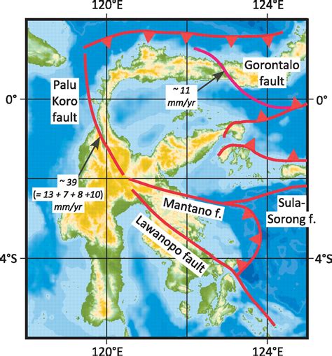
The geological evidence leaves us with an image of a tortured history. The events have created scars: the region is riddled with faults. To the north is the major subduction fault, the North Sulawesi Trench. The northern peninsula is crossed by the Gorontalo fault, and bordered on the east by the double subduction fault of the Molucca sea. On the western side of Sulawesi runs the Palu-Koro fault. It begins where the subduction fault ends, runs south along the thin neck region of Sulawesi, turns south-east towards Palu and continues to cut across the central regions. Further south, it connects to the Matano fault which runs into the eastern seas where it becomes the East Sulawesi Trench, obviously another subduction zone bordered by the Australian Plate. Another fault continues from the Palu-Koro/Matano intersection, running southeast: this is the Lawanopo fault, which runs past the termination point of the East Sulawesi Trench; this fault shows little activity. There are further, more minor faults but this is enough for now.

from http://alain.lave.be/Indonesie_2009/Lokon/Geodynamique.htm
The next challenge is to imagine how each part of Sulawesi moves. The southwestern part, bordered to the north by the Palu-Koro and Lawanopo faults, move northwest at about 1-2 cm per year, while rotating clockwise by 1 degree per million years. The part north of the Lawanopo fault, comprising the eastern and northern peninsulas and the neck, moves north-northwest at some 4-5cm per year while rotating anti-clockwise at 4 degrees per million years. At the far side of the East Sulawesi Trench, the Australian plate is moving north at 6cm per year, and on east side of the Moluccan double subduction region, the Philippine plate is racing west-northwest at 9cm per year. You can imagine the stress regime.
And this stress lies at the heart of the events in Palu. The conflicting movements of the southwestern and northeastern blocks were what generated the destructive earthquake.
Major earthquakes are a frequent occurence in Sulawesi. They occur mainly along the northern and northwestern coast, along the North Sulawesi Trench and the sub-sea section of the Palu-Koro Fault. Along the north coast, there have been 4 M7+ quakes since 1990 (two of which formed a double), while in the northwest where the 2018 quake occurred, there have also been four quakes of this size since 1968. A M7.9 on Jan 1, 1996, a little north of the 2018 quake, was the largest event during this time. The 2018 quake was the most southerly of this series.
The Palu-Koro Fault

The Palu-Koro Fault is the San Andreas fault of Sulawesi, splitting the country in two. After it turns in-land, it runs from the Makkasar Strait towards the Gulf of Bono, although it peters out before quite getting there. The fault line is easily distinguished in maps, running straight as a ruler. North of Palu, it has formed a wide bay which at Palu becomes a wide valley, and 25 km south of Palu the valley narrows to a deep scar. Along Palu Bay, the main fault runs along the western side. It is a ‘left lateral slip-strike fault’: look across the fault, and you will see the other side move left. But there is also extension going on, caused by the opposite rotation of the two sides which makes the two side pull a apart. The movement along the fault is some 3.9 cm per year, and the bay shows extension at a rate of just over 1 cm per year.
Once the valley narrows, the location seems to shift slightly. It now continues along the line of the eastern side of the bay and valley, rather than the western side. Images of the narrow valley make it appear remarkably like parts of the San Andreas fault, although it appears much deeper incised. Earthquake activity in this part has been minor, but it is not known whether that is because of a lack of long-term monitoring. But there has been activity along the wider valley, including an M6.3 event about 20 km south of Palu in 2003.
The valley is bordered by steep cliffs, especially on the west side. This already indicates that the fault is very active. If events are infrequent, erosion has time to wear down the slopes and make them shallower. There is indeed geological evidence for three earthquakes of size M7-8 in the past 2000 years, or one such earthquake every 700 years. This may not be complete: in tropical climates, erosion can remove traces rather quickly and the dense vegetation also doesn’t help. Together, the three events involved movement of around 30 meters. This is clearly not enough: over that time the fault should have moved twice as much. A paper in 2017 by Watkinson and Hall pointed out the discrepancy. Either much of the movement happened smoothly, or events were missing from the data and the earthquake risk here had been underestimated.
The maximum size of an earthquake is set by the length of fault that can rupture in one event. This can be limited by step-overs, where a fault moves across by a few kilometers and continues there. It had been argued that such steps were present in the Palu-Koro fault on-land, with one paper claiming four parallel faults. If so, earthquakes here should be limited to M6-size events. But if the on-land segment was a single, continuous fault, this was optimistic. In that case, Watkinson & Hall found that it was capable of generating a M7.6 earthquake. In hindsight, they were remarkably close with this value.

The Palu valley. Source: http://travels.davidmlawrence.com/Indonesia/Sulawesi/Palu.html
The 28 September 2018 Palu earthquake
The 2018 event started with a M6.1 foreshock, close to the top-end of Palu Bay. It struck just north of Donggala and lasted 10 seconds. (There have been reports that there had been earthquake activity along the southern part of the fault for some months before the event but this is uncorroborated.) Three hours later, at 6:02pm local time, came the main shock, an M7.5 which began a bit further north. It ruptured the Palu-Koro fault over a length of 100 to 150 km, terminating some distance to the south of Palu. The city of Palu, which had been build on top of this fault, was hit by three disasters in quick succession.
Moving the earth
The first disaster was the earthquake itself. How strong this event was can be seen from the amount of slippage. The map below was published on twitter: it used before-and-after satellite images to measure pixel offsets. In the city, the movement across the fault was 6-8 meters. (A gif of two sentinel images shows the shift of part of the city: you can see it here but be aware that the speed is set to a rate which seems in the epileptic danger range. After a while you’ll recognize the straight line running through the city, just right of the centre.)

Further south the movement was less but it appears that much of the broad valley south of Palu still showed rupturing. However, the end point of the rupture is not well defined. And we don’t know what the displacement was to the north where the fault runs under water! As an aside, the line of movement through the city shows exactly where the fault reaches the surface. It is indeed along the western side of the valley.
In hindsight, the research done the year before which found that the known earthquakes were insufficient to accommodate the known slippage of the fault could have been a warning sign. Rather than a sign of a-seismic slip, it may have been the first evidence that this fault was primed to fail.
Liquefaction
The second, and worst, disaster came in tandem with the earthquake. In parts of the city, the soil turned to liquid. This effect has been seen in a few other earthquakes, most notably in Mexico City, but in Palu it was particularly destructive. Liquefaction can occur in wet sediment, and is a problem for instance in areas where the soil has been raised through infill to bring it above water level. Palu was at particular risk of this: the soil hit all the danger buttons, being water logged and low lying. The fact that the event happened close to the end of the rainy season may have contributed.

Liquefaction can be induced by earthquakes when the shaking moves water around. The soil suddenly looses its strength, and becomes liquid. In Palu, this happened in areas with shallow slopes. The liquid mud found itself unable to hold on, and began to flow down the slope. This can happen on slopes as shallow as 1-2 degrees. Videos indeed show buildings moving sideways. Whole streets were swept away. This was probably the most damaging part of the Palu earthquake, and the cause of the majority of casualties.
Tsunami
The third disaster came shortly after, and this has received the most attention. A tsunami warning went out shortly after the earthquake. The early prediction was for a quake of 2-2.5 meters. The quake happened shortly before high tide, and this did not help. The tsunami duly arrived. According to some reports, a total of three waves hit Palu. There is some confusion about the timings, but it appears that the first one came at 6:10pm, within ten minutes of the quake, the second 8 minutes later and the last one arrived a little after 6:30pm. The highest waves were some 6 meters tall, twice the height that had been predicted.
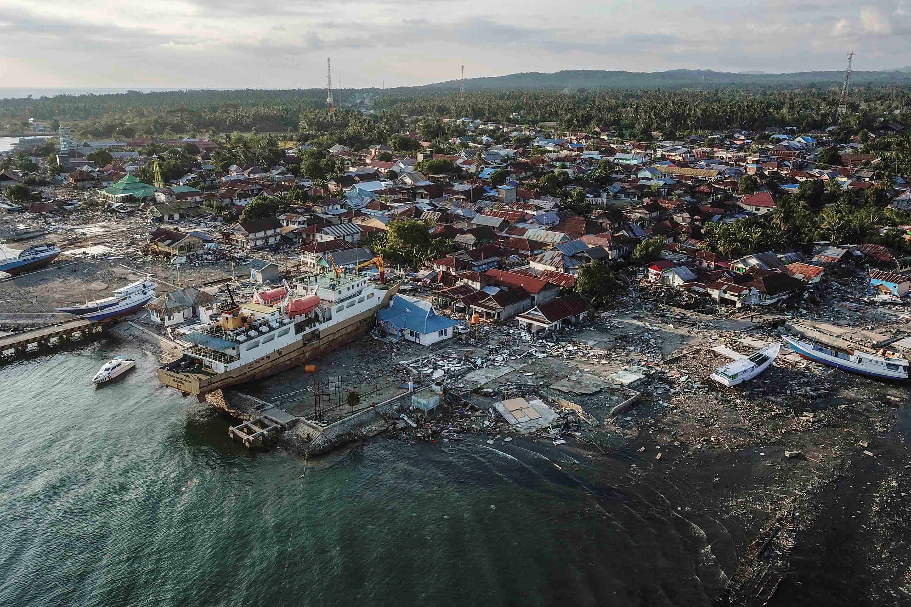
Donggala after the tsunami
There has been much discussion about the tsunamis, focussing on the missing warning systems and the unexpectedly high waves. On the first part, the answers are becoming apparent. A tsunami warning was send out. It was withdrawn after some 30 minutes, with some dispute whether the final wave hit before or after that precise time. (One report claims that the warning was withdrawn after 5 minutes.) The warning was probably withdrawn too early. It was based on the expected travel time from the location of the earthquake, but perhaps did not take account of the waves washing back and forth in the bay. In the end, there were no more events afterwards, so even though it would have been wiser to wait longer, this aspect did not add to the casualties.
A system of buoys which measure tsunami wave in the open sea was installed after 2004. It is not clear that any of these were in the right place for the Palu event, as the waves only showed inside the bay and probably originated there. But this was a moot point as apparently none of these buoys remain operational. Hardware was stolen and maintenance was not taking place – the first is not unexpected in a region where entire ship wrecks are stolen for their iron content, and the second shows that to build something is cheap but to maintain expensive, which is the wrong way around for government funding. Finally, the system to warn locals about the impending tsunami relied on mobile phones and loudspeakers. Both were out of operation after the earthquake when mobile transmitters collapses and electricity went off. But even if the warning had been received, it is not clear that people would have taken heed.
But why was the tsunami so high? This remains an unsolved problem. Tsunamis form when part of the sea is displaced, because of the sea floor going up or down, or a landslide falling into the water. In a slip-strike event, the sea floor moves horizontally. It is harder to create a tsunami in this way, and although there have been tsunamis generated by past slip-strike events, they were mostly small or caused by landsldes. There was no tsunami outside of the bay, and it appears it formed within or very close to it.

The first possibility is that it was caused by a land slide. The image shows the bathymetry of the ocean near Palu. There are indications for extensive land slides which have taken place in the past. Such past sub-sea landslide may have become destabilized, or a new event may have occured. This has a high degree of plausibility, and would explain why Donggala, at the entrance to the bay, also had a large tsunami.
The second possibility is that the slip-slide in the bay took place on a steep slope. In that case, the 6-8 meter movement (or more!) could have pushed the rock face out, and this does displace water. There is indeed a steep gradient inside the bay, from 10 meters near the head to 170 meters further out, to 1000 meters outside of the bay. This remains speculative though. However the fact that over the past century there have been three tsunamis associated with earthquakes on the Palu-Kolo fault (1927, 1968 and 1996) shows that this slip-slide fault is capable of this, somehow.
The third possibility is that the shape of the bay amplified the wave much more than expected. Palu Bay is a fairly narrow inlet and runs from deep to shallow. Tsunamis grow taller as the sea become shallower and the wave slows down. In water of 200 meter deep, the tsunami travels at 160 km/h, while in 10 meters deep water, it goes at 35 km/hr. Models for Palu Bay find that the wave would increase in height by a factor of three while traveling into the bay. That predicts a maximum height of 5 meters which gets close to the actual events, but this models is for higher waves outside of the bay which were not seen.
An interesting point is that at a depth of 200 meter, the tsunami speed would travel along the bay in 5 minutes, with a wavelength of about 40 km. The waves came some 10 minutes apart. This could be a resonance of a standing wave, given the length of the bay of 20 km. A standing wave would have impacted mainly both ends of the bay, where indeed Palu and Donggala are located.
The jury remains out.
Final point
The Palu 2018 earthquake will be studied for years to come. It shows how dangerous it is to build a city directly on a major fault (Wellington, take note), and how important it is for detailed studies of past behaviour of a fault, not over decades but millennia. It shows the need for a working tsunami alert system, with training to make people aware of the system. We need to understand tsunamis better, with detailed models of coasts and the local bathymetry. But perhaps most important is the danger of liquefaction. This, more than anything else, is what turned this disaster into a catastrophe. Some localities are not safe for building on. When all the relief work has come and people are ready to rebuild their lives, perhaps they should be encouraged to do so away from the danger zones. We can’t change the past — but we can still change the future.
Albert, October 2018

A stone-age megalith of Sulawesi


100th anniversary of the start of Katla’s last eruption today!
New post is up. What is up at Iwo Jima? And for the serious readers, an appendix on its discovery
https://www.volcanocafe.org/iwo-jima-in-45-eruptions/