
There is more to Flores. The island is spectacular in any case. The Portuguese explorers called it Cabo de Flores (Cape of Flowers) because of the red-flowered flame trees, dotted between the palm trees of the north coast. The landscape is varied, from low-land savannah to volcanic rain forest. It is not as wet here as further west in Indonesia. There are other differences. Flores is east of the Wallace line, the invisible division that runs between Bali and Lombok where there is a sudden change in the flora and fauna. The division goes back a long way. West of the Wallace line was once part of Asia. East of the line it never was: there was always deep water separating the two. Flores is at the heart of a region called Wallacea, where very few large terrestrial mammals migrated from either west or east. Stegodons arrived, but otherwise this was a lost Gondwana. It left ecological room for the komodo dragons to become the top predator, with the stegodons acting as their food source.

The multi-story Mbaru Niang houses of Waerebo
There are some standard items on the tourist trails of Flores. Around the western tip of this 700-km long island, the komodo dragons can still be found. The towering thatched houses in the village of Waerobo have become famous, although not easy to reach. The reefs, dolphins and turtles of the coast are a must-see, and views of the rice fields cascading against the hill sides make a lasting memory. But don’t go there if you can’t live without social media. Broadband is still unknown in many places. It is in many ways like Bali but a century behind. And you should not expect much comfort when traveling around the island.
15 years ago the fame of science came to the island. Remains were discovered of a diminutive humanoid, no more than 1 meter tall, who had existed here as recent as 18,000 years ago. They had lived in and around the limestone cave of Liang Bua. They had picked a good home. The cave is huge, 50-meters across, and was once used as a school. The precise status of Homo floresiensis is still a matter of dispute, but a direct link to the African species Homo habilis is considered most likely. The remains have been re-dated, and now this branch of the human tree is thought to have gone extinct 54,000 years ago. They still managed to live through the Toba eruption, helped by the fact that eruption was several thousand kilometers away. But when modern humans expanded into the region, Homo floresiensis faded away, leaving only a few skeletons and their stone tools. After that, the modern humans found their own isolation. Even today, at least five different languages are spoken across the rugged interior.
The fertility of the soil of Flores points at the volcanic heartland. There are no major calderas here, but plenty of volcanic peaks. The twin peaks of Lewotobi erupt most frequently, with the latest event in 2003. The tallest volcanoes are Ebulobo at over 2100 meters, and Inieri at 2200 meters. But the most famous is the volcano of Kelimutu, just over 1600 meter tall. It has limited activity: in historical times there have been a few small phreatic explosions, but no major events. The celebrity status does not come from the eruptions, but from the small crater lakes left by past explosions. These lakes are a natural wonder. May the mountain never erupt again! Otherwise it could destroy a scene that, had it been in the US, would be visited by millions. As it is, many of the visitors are locals on annual pilgrimages to leave offerings. Local lore has it that these lakes are the soul’s final resting place. What a place it is.


Kelimutu is located in an isolated region on the eastern half and the southern side of Flores. The nearest town is Moni, and the closest city is Ende, 50 km away on the coast and of very limited touristic interest. Walking up the mountain from Moni takes a few hours (or you can drive up most of the way leaving just a short easy walk). The walk goes through dense forest; the vegetation on the slopes makes it look like Australia, as befits its location behind the Wallace line. She-oaks are common. The forest ends at the summit, leaving two of the craters clear of vegetation: the denuded rocks are a consequence of the gas emissions from the summit. A third crater is closely surrounded by trees, already suggesting it has less activity.
Most tours aim to be at the summit for sunrise. This may not the best time to be there: it can be a bit crowded, and the best views are in sunlight whilst at sunrise the sun is often obscured by cloud or fog. You may find yourself having to wait a few hours for the clouds to lift. In any case, the lakes are surrounded by high crater walls and remain in shade for some time after sunrise. For the same reason, it may be advisable to avoid the rainy season (December to March) for your visit. The best time is the dry season, June to September.

The visitor will find three lakes, each about 400 meters across, and with evocative names. The western lake, surrounded by trees, is called Tiwi Ata Mbupu, or lake of old people. The two eastern lakes, which share a crater wall, are called Tiwu Nua Muri Kooh Tai, or lake of young men and maidens, and Tiwu Ata Polo or enchanted lake (or lake of evil spirits, in a less tourist-friendly translation). At Kelimutu, souls are divided according to their age and disposition. These two lakes contain vigorous fumaroles below their surface, which may have something to do with the lack of vegetation. The lakes should be viewed from above, and not be approached: they are acidic, and not by a little. A measurement of Tiwu Nua returned a pH of 0.5! The gas emissions will keep you away from the lakes themselves, if the steep crater walls or fence are insufficient. As a warning, one tourist who got too close died here and his body was never recovered.

The lakes are famous for their ever-changing colours. You never know what you will find. If it is foggy, you have little choice but to wait until it lifts. If cloudy, the lakes are visible but the colours are not so clear and tourists can be disappointed, after their long and perhaps arduous journey. But when the clouds break and the sun lights up the lakes, the colours become vivid. Blue, green and black are common, but at other times it can be white and red. And each lake is different. Even the two adjacent ones are never alike. A cursory glance at the Landsat satellite maps of Flores will reveal how remarkable the lakes are. They featured on an old bank note, a telling sign in view of the famous sights of Indonesia it had to compete with. (Not of a particularly high value though: the 5000-rupiah note nowadays converts to about 25 British pence.)
What colours are you likely to see? Tiwu Nua can be light blue, light green, or white. Tiwu Ata Polo can be red, dark green, blue, or brown. Tiwu Ata Mbupu is mostly black or dark blue at present but has also been green or white in the past. The colours can change several times per year, in some cases related to the rainy season but in other cases without a clear cause. During 2016, six colour changes were observed. Tiwu Ata Mbupu has been seen to change rapidly, within days, starting from the crater walls.

The colour activity indicates a lively chemistry. The chemistry of volcanic lakes is a bit of a hot potato. Most research is done on the CO2 content of volcanic lakes, which are seen as a particular threat ever since the disaster at Lake Nyos; there is perhaps less research on other aspects. But the chemistry of the Kelimutu lakes is of interest to science: the chemical conditions are extreme due to amount of dissolved gasses and minerals. The ocean underneath the thick ice of Europa, the frozen moon of Jupiter may have such a chemistry. This ocean has been mentioned as a candidate for life but this may be optimistic, seeing that similar volcanic lakes provide a very hostile environment. What are the Kelimutu lakes like?
The lakes
Tiwu Ata Mbupu, the westernmost crater, is the centre of a larger crater. It is not fully stable: during rain storms it suffers from landslides where the sides slump into the lake, including boulders. Part of the wall is stabilised by two peaks. Kemmerling in1929 reported fumarole activity both within and around the lake. There was still activity in the 1970’s, but none is present now: of the three lakes it has the smallest gas input. Gypsum crystals have grown in the cracks of the rocks around the lake. The lake is just over 60 meters deep.
Tiwu Nua, the northwestern of the pair of lakes, has vigorous hydrothermal activity, with a strong plume in the centre of the lake. There used to be fumaroles around the lake as well but they are not currently active. The plume convects the water and brings a yellow froth on the surface. Rain scatters and removes the froth. Tiwu Nua is the deepest of the three lakes of Kelimutu, with a reported depth of 127 meters. It is also the most volcanically active: the eruptions of 1938 and 1965 both took place here.

Tiwu Ata Polo, the southeastern one of the central pair of craters, has a thermal plume in the northwest part of the lake. Gas bubbles (probably CO2) show evidence for the hydrothermal activity but the activity is variable. Older fumaroles on the eastern wall are no longer there. The gas input into the water is intermediate between the other two. A white froth is present on the lake’s surface around the plume when the convective activity increases. Some of the waters finds its way into the river Watu Gana. The lake is just over 60 meters deep.
Measuring the water chemistry has been an adventure. The craters are deep and the water is difficult to approach, and both the equipment and the human operators need to be resistant to very aggressive corrosion. A small number of measurements have been made, both of the water and of the sediment at the bottom, but we lack long-term monitoring. It would be nice to know exactly the compositions year-round, for each lake and for each colour of the water, but we don’t. Here is a brief summary of what we do know.
Tiwu Ata Mbupu has the most diluted composition, as might be expected due the lower gas input. The pH is around 3 (orange juice), increasing to 4 (tomato juice) in spring at the end of the rainy season, SO4 is 1600 ppm, and calcium is 430 ppm. Chlorine is 90 ppm and sodium 500pm. The sediment at the bottom is higher in iron than found in the other lakes. Tiwu Nua is 10C warmer, has a pH of 0.5, SO4 is a staggering 50,000 ppm, chlorine 25,000 ppm, sodium 940 ppm, iron 2600 ppm, aluminium 8600 ppm, but calcium is similar to Tiwu Ata Mbupu. There are measurable amounts of lead (4 ppm) and strontium (11 ppm). It has very low oxygen levels. Tiwu Ata Polo is a bit less extreme, with a pH of 1.8 (coca cola), SO4 of 10,0000 ppm, chlorine 3,000 ppm, sodium 240 ppm, iron 1200 ppm and aluminium of 1600 ppm. The bottom sediment is enriched in sulfur and arsenicum The lake lacks the warm water of Tiwu Nua, in spite of being right next to it.
This make the water chemistry of Tiwu Ata Mbupu acid-sulfate, Tiwu Nua acid-brine, and Tiwu Ata Polo is an intermediate acid-saline. The differences are strongly related to the hydrothermal activity, which is almost absent in Tiwu Ata Mbupu, very strong and warm in Tiwu Nua, and weaker and colder in Tiwu Ata Polo. It changes over time. Tiwu Ata Mbupu used to be much more acidic but this lessened over the past century as the hydrothermal activity decreased.
There are two types of hydrothermal activity in lakes. In the usual one, ground water circulates through a layer heated by volcanic activity below, and comes back to the surface. The heating does not affect the composition of the water, and if it enters a lake, that lake becomes warm and perhaps enriched in H2S, but only mildly acidic and not particularly hostile. The other type is where the water interacts with volcanic gasses, and becomes enriched in sulfur, chloride, and fluoride. This can happen either underground, with the resulting water injected into the lake, or the lake can absorb gasses directly from fumaroles located below the surface. Such lakes become highly acidic, and salty. The Kelimutu lakes are clearly of the second type.
The three lakes are probably fed by volcanic gasses from the same source. The difference is in how the gas gets to the lakes. Tiwu Ata Mbupu has cool fumaroles with low output. Such fumaroles can lose HF and HCl due to interaction with rock, leaving an input into the lake which is rich mainly in H2S (oxidized to SO4) and CO2. Tiwu Nua, in contrast, is fed by hot fumaroles with a high volume, which inject HF and HCl, in addition to the H2S. The volume is so high that part of the sulfur precipitates out of the water, leaving the lake water a bit lower in S than would be expected from the abundances of the other constituents. Tiwu Ata Polo is intermediate. Not all elements remain in the water. The sediment below all the lakes have high levels of copper and vanadium, which are found in the water only as trace elements.

So what causes the colour changes? It is clearly related to the pH of the water. Tiwu Ata Mbupu changed from green in 1930’s, and white in the 1970’s, to black in recent years, as the pH increased. The other two lakes are usually green to turquoise; Tiwu Ata Polo can also be red but Tiwu Nua (the most acidic) never is. Some changes are seasonal, and probably related to the amount of oxygen in the water. The water temperature could play a role: when Tiwu Nua was heated to over 60C in the 1930’s, the water went white.
The colours are largely due to solid particles (precipitates) in the water which reflect certain colours, but absorption of some colours by molecules in the water also plays a role. In other places, colour is often due to life. Not so in Kelimutu where conditions are so extreme that even algae are unknown. Here the colour seems largely due to the chemistry of the water.
Light
Let’s visualize how it works. Light enters the water from above. Some light is absorbed in the water, and some is scattered by particles and molecules and goes off in different directions; a fraction of this makes it back to the surface and reaches our eyes. The lakes are deep enough that reflections from the substrate at the bottom can be ignored. The perceived colour depends on which colours survive the turn-around best. If a certain colour is efficiently scattered, it will be present in the light reflected back to us. If it is efficiently absorbed, it will be missing. If it is not easily scattered, it will travel deeper into the water and therefore suffer more absorption: such a colour will underrepresented in the reflected light.
For instance, sea water scatters blue light well, red light less so. This makes the sea look blue-ish. Put red algae in the water, and the blue and green light are absorbed by the algae, leaving only the red light to come back to you: the sea turns red – often dark-red as there isn’t much red light to begin with.


An example of scattering versus absorption comes from opal. Against a white background, it seems yellow, but against a black background it is blue. That is because blue light is scattered inside the opal, and comes out in other places where there is no background light. The light that pass straight through has lost some blue, and thus appears yellow. The iris of the eye provides another example. Your eye may look blue, but there is no blue pigment in it. Instead the person looking in your eyes sees the colour of the scattered light. Add some colour (melanin) to the iris, and it becomes darker.
Particle size also plays a role. Very small particles (less than a micron in size) scatter blue light much better than red – if they are present, water can go a vivid blue. Larger particles scatter all colours equally well. This is the case for water droplets in clouds, and is the reason why clouds are white.
The colour of the reflected light depends not only on what happens in the water. It also depends on what you put in, i.e. the illumination. A cloud in the shade of another cloud goes grey, which can be described as white but not bright. If the sea reflects a cloudy sky, it lacks the blue light to begin with, and so the sea turns darker. You can’t easily see blue water in the absence of direct sunlight. This affects not only the Cote d’Azur, but Kelimutu as well. Don’t expect bright blue colours if there is no sun. It is one reason why sunrise is not always the best time to see the lakes.
But in the presence of sunlight, with all the right conditions, which molecules and particulates cause the magic colours of the lakes? Why do the lakes show different colours even though the illumination is the same?
Chemistry

Yellow sulfur mats on a light blue Tiwu Nua. Image from Pasternack and Varekamp (see bottom of post)
The yellow froth seen on Tiwu Nua is easiest to explain: it is pure sulfur, brought up by the intensive hydrothermal fumaroles. Its staggering concentration of SO4 already points at the oversupply of this element: the sulfur input is estimated at 85 tonnes per day. Tiwu Nua is thus very similar to the sulfur lake of Kawa Ijen, and other hyper-acidic lakes. The sulfur mats can form through a gas reaction involving SO2 and H2O, forming HSO4 and S. The sulfur precipitates out because of the sheer amount in the water of Tiwu Nua. The mats reflect strongest in the red and green, and the two colours combine to give their yellow colour.

The relation between pH and iron. From Pasternack and Varekamp (see bottom of post)
The red colour in the water is due to precipitating hematite, or Fe2O3. It forms when oxygen levels are high, and disappears again when oxygen drops. The change between red and green water correlates with the rainy season: the rains oxygenate the water while it lasts. Put too much oxygen in, and the water turns brown or black. Hematite does not form at very low pH, below 0.5, and thus Tiwu Nua, with the most extreme pH, is never red.
The other colours are harder to pin down. Green has been attributed to iron (Fe2+ to be precise) which would explain that change from green to red and back as due to rust – iron reacting with oxygen to form hematite. During the change often the water turns yellow, which is in fact a combination of red and green. However, no water measurements have been taken during these changes so this is not confirmed. Sulfur is less likely, as it forms yellow mats but does not make the water itself yellow.
Blue is the hardest colour. It has been attributed to hydrated metaloxides, involving aluminium or iron. Many types of micro-particles can cause blue colour. In the famous example of the Rio Celeste, it is aluminosilicate. Hydrated copper-sulfate may be a possibility. All three lakes can show a blue/turquoise colour but the precise origin is not yet clear.
The colour white is often seen when levels of volcanic activity are high. It may be that an intrinsically bright sediment is stirred up by overactive fumaroles, such as salt or gypsum.
Colours of change

The figure above shows the colour changes over the years, derived from Landsat imaging. It is taken from the recent paper by Murphy et al. (see the bottom of the post). The bottom panel shows the temperature changes over the 30 years. Tiwa Nua shows temperature fluctuation with a spike around 1997 when there appears to have been a spike in its volcanic activity. The top panel shows the colour as perceived by our eyes. During the temperature spike, Tiwa Nua turned white.
The second panel, called hue stretch, shows what is the dominant colour in the reflected light, leaving everything else out. Grey with a slightly reddish tint would show here as bright red. It is the difference between the colour depicted on the paint tin, and the colour it becomes on the wall.
The third panel is the saturation. It shows how dominant the colour of the previous panel is. A low value means that a lot of the light is from other colours. A high value means the majority is the one shown in the hue stretch.
The fourth panel is the ‘value’, a term somewhat lacking in descriptive value. It gives the strength of the reflected light, where ‘1’ is white and ‘0’ is black.
Let’s look at Tiwu Ata Polo (TAP in the figure). From 1997 to 2009, the dominant colour was green, yellow or red. But the saturation was low, so these colours didn’t stand out so well, and the value was low so the lake appeared quite dark. The red would have appeared as brown: you would have needed very bright light to pick out the colour with your eye. (In the tropics, on a clear day the light can be fantastically bright. At times it felt you could get sunburn from moonlight. The person who called Africa ‘the dark continent’ clearly had never been there.) After 2009, both the saturation and value went up, and the colour changed to blue and green. Now the lake appeared colourful to the eye.
At Tiwa Nua, the 1997 event made the water blue/green, with low saturation but high value. It appeared white to the tourist’ eye. The reflectivity (value) of this lake is consistently higher than that of the other two lakes. Tiwu Ata Mbupu has the lowest reflectivity (value) and therefore may appear black.
The data shows that the saturation has two main states: it is either around 0.2, or around 0.6 ( Tiwu Ata Mbupu has been slowly moving from the low to the high value). The dfference coincides with a change from green/yellow to blue. The most efficient scatterer in the lakes is blue, either because it is intrinsically that colour, or because it consists of very small particles. But only Tiwu Ata Polo shows a good correlation between ‘value’ and saturation. For the other two lakes, the two parameters seem to be determined by different water components.
Rain makes a difference. Both reflectivity and saturation increase towards the end of the dry season. The combination gives the strongest colours.

From https://www.higp.hawaii.edu/~wright/bv80.pdf
Future
The miracle of the three lakes will not last forever. Nothing does around an active volcano. A major eruption would destroy everything; minor explosions could do severe damage. Such explosions happened in 1938 and 1965 in Tiwa Nua. The wall between Tiwu Nua and Tiwu Ata Polo is currently 35 meters above the water level. It used to be much higher. Kemmerling, in 1929, stated it was 70 meters above the lakes, and he was told that 70 years earlier, the wall had been as high as the crater wall. It is crumbling under volcanic attack. At times, the two lakes may already be intermingling. Eventually, they will become one lake and the amazing contrast will no longer exist. It could happen quite soon, and is likely to happen within the next 50 years.
But new eruptions can also create new things. Who knows what new miracles may appear in the decades after the next eruption. The Earth is an amazing place. We should always expect the unexpected, and look down in wonder.

Source: wikipedia. Click on image for full resolution
Further reading
A brief introduction can be found on NASA’s Image of the day: Image of the day, based on the new paper by Murphy et al.
This paper by Sean Murphy et al. is good starting point for research into Kelimutu:
Color and temperature of the crater lakes at Kelimutu volcano through time, published in Bull Volcanol (2018) 80:2 (https://www.higp.hawaii.edu/~wright/bv80.pdf)
The classic work on the water chemistry is the paper by Pasternack and Varekamp, The geochemistry of the Keli Mutu crater lakes, Flores, Indonesia, published in Geochem J (1994) 28:243–262. (https://www.terrapub.co.jp/journals/GJ/pdf/2803/28030243.PDF)
For homo floresiensis, a good starting point is Baab, K.L. (2012) Homo floresiensis: Making Sense of the Small-Bodied Hominin Fossils from Flores. Nature Education Knowledge 3(9):4 https://www.nature.com/scitable/knowledge/library/homo-floresiensis-making-sense-of-the-small-91387735
On light colouring by scattering, try The colour of the sky by Dietrich Zawischa

Kelimutu is an amzing place. Just beware of the monkeys.
Albert Zijlstra, July 2018


any info on the mount Rinjani earthquake on Lombok island, was it related to Rinjani or barujari- Samalas volcano?
We don’t know! Probably not, as the quake is offset from the mountain, but significant quakes in this area seem quite uncommon. There hadn’t been anything recorded on Lombok this strong for at least a century. People should be aware that this increases the chance of a second event, at least for the next few weeks.
Very Interesting… Thanks, i always wondered about the colors and You write so well. Thank You! Best!motsfo
Thank you! I found this one quite hard to write: it took me much longer than normal. I am not a chemist and the popular articles on these lakes seem to not really explain much, so I had to some fast learning. Corrections are most welcome.
Thanks Albert, really enjoyed that ☺
And that, ladies and gentlemen, is how mineralization works.
Side note: The solubility of gold is highly affected by cyanide levels and water temperature. As water percolates through rock, it picks up a bit of gold in solution. Once the temperature pressure drop to a certain level, the gold precipitates out and forms a deposit in the rock strata. Other similar solution chemistries deposit copper or silver. This is why silver is typically recovered as a byproduct of copper mining. They are both deposited by a similar process.
Your luck may be different in accessing these papers, but they go into a discussion as to why some of the calderas in Cabo de Gata volcanic field in southeastern Spain are mineralized and others are not. Spoiler alert: It has to do with water percolation.
https://link.springer.com/article/10.1007/BF00205246
https://link.springer.com/article/10.1007/BF00205247
Different place, but similar geochemistry did it.
https://en.wikipedia.org/wiki/El_Indio_Gold_Belt
Rodalquilarite (iron tellurite chloride mineral): The sort of deposition that this process tends to yield. (Wikimedia Commons image)

“Rodalquilarite was first described in 1968 for an occurrence in the Rodalquilar gold deposit of Almeria, Spain”
There are some mining applications where an acidic wash is percolated through mining trailings to leach minerals from pile, or the water is directly injected into the strata to get the minerals.
Naturally, there are environmental concerns for this process. Part of US EPA regulations stated that following leach mining, the aquifer has to be restored to pre-mining conditions. With Uranium mining, that means that the company would have to inject uranium back into the aquifer that it had extracted. The whole situation is quite byzantine in it’s regulations. Unrelated to leachate mining, but the Guy Arkansas quake swarm of several months ago, did NOT have any intentional fracking operations going on. The wells in question were Type-II disposal wells. Those sort of wells are heavily monitored by the EPA regulators to ensure that the well head pressure will not cause the borehole to exceed the fracture gradient of the strata the well is in. In the Guy Arkansas case (in my opinion), the increased pore pressure activated a previously unknown extension of the Commerce Fault system extending down from Missouri. The Commerce fault is essentially a boundary fault of the Reel-Foot Rift system. (New Madrid Seismic Zone)
{The plotted fault plane at Guy Arkansas almost perfectly lines up with the lay of the commerce fault several hundred kilometers away}
Usually this acidic wash is produced in situ bu percolating oxygen-rich (ie surface) water into sulphide deposits. This oxidises the sulphide to (eventually) sulphuric acid which then dissolves the relevant metal (often copper) which washes out with the water. This is then collected, the metal separated by electrolysis and the resultant sulphuric acid is then pumped back to the top to percolate through.
I always thought this was a delightful bit of industrial chemistry. Note it doesn’t work well on oxide ores because the huge amounts of acid that would be required would make it uneconomic.
OK, I’m a nerd….
Nothing wrong with that. One thing that VolcanoCafe has been long trying to answer is how mineral deposits wind up where they are. (The question comes up from time to time). We tried to do a specific mineralization post some time back, but the content got a bit esoteric and tended to loose people. Albert unintentionally hit it from the other corner and nailed the topic, keeping a volcanic train of thought.
Collapse event just happened. Visibility on the two live video feeds is poor but it happened around or just before 8am on the video clock when it became very dusty
But You can see the pressure wave light up the vog for an instant.
Yes, you are right. 7:59:49. It travels form right to left and upward as if it comes from just below the cliff edge on the right. Immediately afterwards you can see the far side collapse.
Nice catch Motsfo!
Mac
Just a reminder of how much change there has been up at the summit.
Black swan? Exponential global warming? Is warming happening faster than expected?
Past few weeks many records beaten across the world. Extremes seem to be following an exponential increase, not a linear one!
After tomorrow the official forecast is of 50°C for south Portugal. Might be highest temperature ever recorded in Europe. Absolutely astonishing.
Just a week ago, the African record got beaten.
What if temperatures start tracking above the models in the next few months to years. Could tgat mean we crossed a threshold and rapid climate warming occurs in a decade, just like it did at the start and end of the Young Dryad.
A deadly black swan in the horizon?
“…it’s not a fatalistic view of statistics. It’s just a firm reason to not be surprised when something happens… no matter how weird it may seem. In all likelihood, it HAD to happen… eventually.”
Today another record beaten…
1 August: earliest “Earth Overshoot day”!
https://www.overshootday.org
“History.
The concept of Earth Overshoot Day was first conceived by Andrew Simms of the UK think tank New Economics Foundation, which partnered with Global Footprint Network in 2006 to launch the first global Earth Overshoot Day campaign. At that time, Earth Overshoot Day fell in October. WWF, the world’s largest conservation organization, has participated in Earth Overshoot Day since 2007.”
Optimists say we still are able to avoid a world scale tragedy. We better hurry then.
You can’t take local hot records to have a global picture of the situation, have you ever seen the papers with world map temperature’s anomalies? While some areas record positive anomalies other areas record negative anomalies. For example in the meanwhile there are negative anomalies in south atlantic.
To give the global picture, this is the map of surface temperature anomalies in June, relative to the everage for the period 1981-2010. Most areas are positive, a few are negative especially around Antarctica. The southern atlantic ocean is positive, not negative. The ECMWF writes
“Temperatures were exceptionally high over large parts of northern Siberia in June 2018. They were also well above average over much of the USA, central Canada and North Africa, and over the Middle East and northern China. Regions that were colder than average include northern Canada and Greenland, western Russia, north-western Africa and southern parts of South America. Parts of the wintertime Antarctic also had temperatures that were very much above average, but other parts were very much colder than average.”
For the full year July 2017 to June 2018, a few regions are below average especially where La Nina had an impact. The large majority of the world’s area is above average.
The difference between weather and climate is correct. But the warming has increased the chance of hot weather. Globally, June 2018 was among the four hottest June’s ever (it was officially number 2 but the difference with number 3 and 4 is insignificant). It may be worth noting that the four hottest June’s were (not in that order) 2015, 2016, 2017, and 2018. Says it all, really.
Ooooh… nice. Cooler central atlantic! That means less likely for Cape Verde ass kickers 😀
Though its actually probably a function of the MJO circulation. But, less tropical storms is a plus in my book. 2004 was not fun here.
2004 was nuts down there and I don’t want anything sneaking up the coast in September or early October. Irene and Sandy were a pain here in Connecticut…but it could have been worse.
Ivan made downtown Pensacola reek of fish and feces for three months.
Yes, its always been pretty clear that the estimates were too conservative. Trouble is that the reality wouldn’t have been believed. However its far too late to really stop it, to do that we should have been building nuclear power stations by the 100’s in the 70’s. We didn’t because ecofreaks stopped any advance so now here we are.
The really big problem is going to be the rise in sea levels, which will destroy large amounts of the worlds fertile land and most of the worlds major cities.
I am a farmer as well and hold a degree in horticulture and natural resources conservation. I object to being called an ecofreak. There is good reason not to pepper the land with nuke plants and man is the major one. We have a propensity to cut corners to save money and the long term result of a big nuke plant accident is beyond many lifetimes. we will never be told the whole outcome of Chernobyl or Fukushima, how many people actually died over 50-60 years how much land was destroyed etc.Instead of name calling people concerned with our environment we might be better served going after the industrialists that pollute and then walk away or pay billions to unethical politicians to ignore or call fake news the rising evidence of global warming. Sir the trouble is NOT those concerned but those that know what is happening and don’t give a damn because of personal wealth to be made!
Regulations in western states became so onerous that tree harvesting has became nearly impossible. The forest service adopted a “no fire at all” policy and decades upon decades of undergrowth built up until the forests became highly volatile tinderboxes just waiting for a chance to burn. Now California is seeing the consequences of policies put in place to buy votes and make people feel good.
Other states, such as Florida, have a different mindset when it comes to forest management. Prescribed and controlled burns are allowed to happen in order to more closely simulate the natural life cycle of the woodland.
Though it’s not impossible, you rarely see a “Crown Fire” event in states that have this controlled burn policy.
Crown Fires are particularly damaging because the ultra high temperatures literally sterilize the soil and eliminate any seedlings or seeds that were deposited during the life cycle of of the forest.
The number of people who have died from coal exhaust far exceeds any casualties from the nuclear industry. (The White House would need a change of name had it been close to a coal plant.) That is true even when including the long term cancer rates from Chernobyl. Fukushima is not yet known but will be much less than Chernobyl. Just counting mining accidents in the coal industry already exceeds nuclear (but these rates have dropped fast in the past decades), but death rates from coal dust is estimated as over 10,000 per year in the US alone. Worldwide it is not far off a million per year.
The current nuclear plants are much safer than the 1950 ones. Nuclear will be needed for the next 2-3 decades. I have gone through the numbers and believe we cannot get enough renewables to phase out fossil fuels for some time. Energy efficiency will eventually close the gap. We do need to end fossil fuels sooner rather than later. What we are seeing this year is just the taster for what is to come. Nuclear fission is temporary (for one thing, uranium is also a limited resource), but one we need if we want to save the planet.
(Well – the planet will be safe. It is us who are in danger.)
looks like i might have to add a line to my ditty….
and then i’ll eat Your camera……
cause it’s frozen hours ago amid a lot of smoke.
hope not….. i’ll miss that cam….. motsfo
Yes, it looks like the forest fire (lava triggered, probably?) may have taken it out. It may be difficult to get to that camera.
All roads cut off, fire brigade can not cross safely the current lava fields, even those in early eruption period(May) yet.
The rain in Summer can not stop, slow “volcanic local tree death dryng out dead wood and brush” in Hawaii, so the firewood brush and acid rain mortals will burn in the end, as the forever hot lava singes dead wood and veg…
The Webcam will be missed alright. I feel the same loss.
If I were in the area and USGS,(young fit adventurous types) I would hope for resupply. Its the right thing to do.
The people need to see.
Sorry if I am seeming to be, all Gung Ho about it and all that.
My neck is red from the sun and the cold. I could be overstating, if you like.
Depends on how it looks from where you are.
Bardarbunga star. SE side of the caldera.
Remember “Weekend at Bernies?”…
https://www.vice.com/en_us/article/9kmqy7/inside-new-orleans-extreme-embalming-funerals
another cam for Kilauea is: Lavacam.org not live but frequent updates……
Looking at the summit tilt meter, it shows a clear change over July. Te peak varies with strength and location of the quake. but if you take the point where it settles immediately after the shock from the quake, the line becomes clearer, tilting at about 6 microrads per day.
Looks like Cayambe in Ecuador has erupted, with ash to FL360. Still awaiting official confirmation from IGEPN. If confirmed it would be its first since 1786. Wouldn’t be that surprising after the strong unrest in 2016-17.
Now confirmed that there was NO eruption after all. Took the VAAC 3 hours to sort it out. A bit too long I would say. Too late anyway, that not-from-the-Netherlands idiot has already picked up on it….
I like your outlook! Not that nice, but I’ve been chastised for that before. In this case, the target deserves it. (Pure alarmist intending only to scare people)
I used to watch him a few years ago, originally because he was usually the first to get hold of new vids of holuhraun, but after that ended it became more and more obvious he was crazy… Really the only thing he ever said that sort of actually made sense was that fracking causes earthquakes but that is kind of a given when you know what fracking is… I unsubbed when he said the mid atlantic ridge is a fold mountain range caused by the pacific plate pushing North America to the east……………
I tend to pull the plug on any “news” twit that defies logic or states the absurd.
Caveat emptor applies.
Proposed hotspot track under Greenland. The track seems real and it fits more or less with the plate motion. But it seem surprising that the motion mainly occured before the Atlantic opened, and the track is midway between the two rifts on either side of Greenland. I wonder a bit about whether the heat sign shows a failed rift rather than a classical hot spot.
https://svs.gsfc.nasa.gov/4670
I did read a paper a year or so ago throwing out the hotspot track hypothesis, can’t remember the source now. I know Carl’s a hotspot track denier so he might have some links 😉
I am sure he is not the only one with doubts. It is an interesting signal and it would not be easy to proof it isn’t a hotspot track. The ages they list along the track may be optimistic – if you leave those out, what you see looks like a feature parallel to the other rifts that developed, more or less successful, in the opening of the Atlantic. There was of course an impressive flood basalt in east Greenland and the adjacent area along the UK and further north. But I am not sure that qualified as our version of the Deccan traps.
Honestly after doing that calculation before I don’t think anything will sound as impressive as the Deccan traps. A flood basalt on a rift will probably be like Iceland and most magma will never surface. A hotspot driven flood basalt is driven by the amount of magma available and that can be a huge amount. If Deccan was more similar to Hawaii than Iceland then probably over half of its average supply would be erupted. At the KPg boundary it had 60 km3 of supply so in theory it could do a thorsja lava flow every year for 30,000 years……. As you said it also probably missed a few years with a corresponding bigger volume…
Actually no I did that wrong, that 60 km3/year number was the average erupted volume per year, the supply was probably over 100 km3/year… Potential VEI 8 every 10 years, and actual VEI 8 every 16, a VEI 7 every year, or an eruption like the skaftar fires that stays at peak rate continuously for millennia, and there are people that actually have doubts this could had killed off the dinosaurs… Those over the top disaster ‘documentaries’ that show flood basalts as continuous 10,000 year lava floods are actually correct for once somehow!
IMO: An earthquake of magnitude 3.6 was detected in Mýrdalsjökull glacier at 12:55 today. Some seismic activity has been occurring in the area since yesterday.
Written by a specialist at 02 Aug 13:30 GMT
Jokulhaup announced by IMO, for tomorrow and the weekend.
“GPS measurements from the eastern Skaftá cauldron on Vatnajökull show that the ice-shelf above the lake is lowering. This is an early sign of the onset of an outburst flood (jökulhlaup), which will affect the river Skaftá in southern Iceland. The jökulhlaup is expected to reach the edge of Vatnajökull late on Friday 3 August, with the peak of the flood possible during the early hours of Sunday 5 August.
Travellers are strongly advised to avoid travel in Skaftárdalur during the coming days. In addition to flooding along Skaftá, gas pollution from the floodwater could affect the region, particularly at the edge of Skaftárjökull.”
Location of the cauldron can be see here, if anyone is interested

For some reason I’ve come off the English language version of IMO but google is still translating the update leaving me to decipher this remark about the Jokulhaup: ‘The jaws from the eyelash are usually larger than those coming from the western cat’
Dunno, sounds like we should worry about the eyelashes rather than the cat.
Perhaps it is referring to which regions produce the larger Jokulhaups?
Yes, my thinking too … on both counts ☺
At least you have time to think. I’m stuck in Freakville Florida. My dogs went batshit over something outside. I investigated and found a lady laying in my front yard crying her arse off. As I’m talking to the sheriff’s dispatcher she gets up and wanders off.
Evidently it turned out to be nothing or she was able to avoid detection. At least she left her footwear where she was laying so the deputy didn’t think I was a nuisance twit. (The dispacher even heard her in the background). Had there been anything to it, other emergency vehicles would have responded and I would probably have been contacted for a statement by now. It’s been 4 hours.
Additionally, my dogs haven’t alerted on anything else. They got a treat for their alertness.
Can’t trust a cheshire cat. A beast from the east.
What they are saying is that the jokulhlaups coming from the eastern cauldron are usually bigger than those from the western one.
One of the best written articles I have enjoyed in a long time. Thanks.
The Inflation of Oraefajokull volcano is clear. And accelerating.

Where can I find a link to this?
brunnur.vedur.is/gps/eldfjoll/oraefajokull/ROTH-plate-90d.png and brunnur.vedur.is/gps/eldfjoll/oraefajokull/ROTH-plate-year.png
May be old news, but I just discovered that Berenberg has been added to the Futurevolc site(most info on the volcano is not uploaded yet it seems) http://futurevolc.vedur.is/?volcano=BEE
Up a tick…. 5.4 in Hawaii at 1157 Hawaii time……. Nice…. Best!motsfo
esp. nice from the NE caldera rim cam… even if they have a shuttered speed on it…
11.55 collapse event Kilauea at the webcam, after a long wait this time.
Ref: “Cabo de Flores”
During a Panama Canal transit, I asked a guy standing with me who was studying Spanish (so that he could more easily talk to his wife), what “Mira Flores” meant. His response. “Look! Flowers!”
The only thing I could visualize were early explorers topping the hill and seeing that.
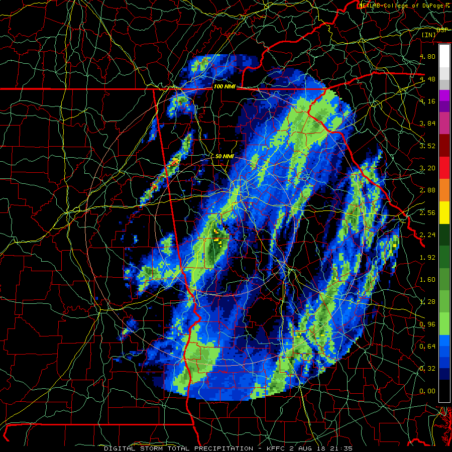
We just had 3-4 inches of rain dumped on us mostly in 2 hours. About 1/2 mile from here it was 4-5 but a small area. This was using Atlanta radar FFC (we are near Newnan). Looking at our county from the Carrville radar (Alabama) it shows us at 4-5 inches with some areas 5-6. Might be a tough first day of school tomorrow. My pond overflowing down towards the creek sounds like a waterfall.
GL Edit Add: On the plus side, maybe now the Georgia Legislature will quit trying to steal Florida’s water. 😛
(There was a legislative fight over water in a river running into a Florida bay. Loss of that would impede oyster and shrimp production.)
Storm totals animation from the mentioned radar.
I hear ya. I slept like a log from the rain. The good bit is that there was not a whole lot of lightning, so the Pekinese didn’t keep me awake from his crying. I’m not celebrating, but not having a lot of HSMV calls might turn out to be a blessing. The road running south of the Carryville exit passes through “bottom-land” for the Choctawhatchee River and floods quite easily. (It’s one of the faster routes from here to Panama City… but you have to be careful after you go south of “Dram Branch Rd.” because there is an assisted living area around the corner and at the top of the hill. (essentially it’s just a small trailer park) You never know who or what is gonna be in the road. It could be a mobility scooter, could be a lawn-mower, could be nothing.)
Ordinarily he hates me. But if there is thunder, he’s on me like stink on hooey.
Here is my question, if anyone understands Doppler radar and ground clutter. The mentioned radar site is very close to our house (Peachtree city) and is part of the national weather service (http://www.aboutnorthgeorgia.com/ang/National_Weather_Service). Would the radar at carrville (nearly east of Montgomery) give me a better estimate of the rain in our area since it has less ground clutter affecting its view at my house? If you look at the map above it looks like the rain curves around a spot, this is the radar site. When viewing the Montgomery radar image this area (radar site) is blanketed by rain and shows rain fall (estimated) of 2.5 – 4 inches.
Rain that lands in Ga should stay in Ga. Florida has enough of its own water. I believe this is still in the courts.
You will get more accurate coverage in a radar display if the region in question is in a clutter free area.
Caveat: Only about 20 years experience in using and studying radars.
I’m not going to hazard a guess about minimum range resolution, for a Nexrad radar it is likely different than for a standard radar.
If you wish, you can dig around here and see if you can find something of use. Most of what I have seen in there is fairly accurate. Do note that the section on refraction only begins to touch on the problem of dealing with it. There is a whole field of study about the effect and taking it into account for tactical planning. The most vexing part of it is the surface duct layer on the open ocean. It’s almost always present in some form and it’s elevation generally mandates whether you can or can not see something on the radar. {Yes, a radar can easily lie you you. For example, a radar is virtually blind to a volcanic ash cloud. Ash clouds are mostly silica, and silica is transparent at radar frequencies.} If you do pick it up, it’s most likely the water vapor condensing out that you are seeing. Eyjafjallajökull did a really good job of demonstrating this to the Airline industry.
Diverting an entire river because of poor city planning is not Florida’s fault.
One advantage that it should definitely be noted that doppler radar possesses is elimination of a lot of clutter. Doppler radar works off movement of objects, which automatically eliminates pretty much all ground clutter. However it doesn’t eliminate things like flocks of birds by its inherent nature: that’s where signal processing comes in and signal processing is where enormous progress has been made in the last 25 to 30 years with the massive increase of computing power over that time.
I miss my pekingese, the most vocal dog, he loved his mommy and let that be known loudly.
Macus, are you going to write about your trip, I understand the weather was not so great and I have an idea how things were in Hawaii, I sincerely hope you had some fun and that the children weren’t disappointed?
I’d love to hear about it, too. A “boots on the ground” report from Kilauea (along with which good restaurants to visit, the temperatures, places to visit…!)
This one is not a bad dog, he’s just a jerk. I wound up with him because my stepson got a divorce. (Turned out the dog was more loyal than his wife) I think his greatest problem is that he’s still angry about the change in households. He used to be well pampered.
Several months ago, I put together a spoof magazine cover parodying The Journal of Human Evolution. Mine read “The Journal of Human Extinction.” And featured some woman at a wedding reception falling backwards off of a deck railing. My point was to illustrate the sheer idiocy of mankind.
Evidently I was not that far off the mark.
https://www.dailystar.co.uk/news/latest-news/720731/sex-robot-doll-japan-extinct-birth-rate-web-clock-endangered-species
Pu’u 8 now, it looks like holuhraun in its last month except smaller.
It will be interesting when the eruption slows to a stop, kilauea has a continuous magma supply unlike bardarbunga so the eruption could resume like a geyser at some point if pressure can build in the conduit again.
I believe it is getting less (and has for some weeks) but it is hard to get confirmation! Another change: Kilauea has started to contact again, since a week or two, after a phase where it seemed fairly constant. I think the lower eruption rate is because of loss of pressure at Kilauea: the caldera has dropped far enough for this to be notable. The time between collapses probably relates quite well to the eruption rate as it measure how fast the magma leaves the chamber.
The eruption will end when the pressure drops so far that the magma can no longer reach the fissure, because it stalls on the way. Once solidified, the channel won’t re-open. A future eruption will have to create a new channel. If the channel solidifies to Pu’u’O’o and further back, that peak will be dead. The only real chance it has to re-start is shortly after fissure 8 ends.
There was a report that channel overflows are reaching (have reached) ares outside of the existing lava cover. That is the biggest risk when the flow slows down.
That’s what I mean, the supply keeps coming but before the conduit solidifies enough pressure builds up that it causes a lava geyser effect. The vent will likely remain open for a short period after the main lava effusion stops, with spattering and strombolian activity resulting. The cone will probably look quite different at the very end than it does now. This activity is fast, fissures 17 and 22 formed very sizable cinder cones (both probably well over 30 meters tall) in only a day or so. Both of these were a main vent at some point so it is likely fissure 8 will do that too.
The caldera is still dropping but it’s nowhere near as much as before, that and the fact the lava now only reaches past the upper part when the flow surges is another indication of this thing slowing down a lot. If the eruption slows down a lot then maybe the next two summit collapses could be far apart, and eruption might completely stop between them, then a final collapse happens, lava erupts vigorously and then the pressure is gone, the supply rate from depth now no longer able to keep it going, the cone will stay weakly active but die soon after. Most likely this will be the end of activity on pu’u o’o too, it’s been exceptional based on its duration and volume, but it’s not the only eruption like it and the previous two never reactivated. It’s likely this event will radically change kilauea, it’s focus of activity switching to summit activity and the east rift becoming inactive, basically repeating the early historical period. It won’t take long for something else to happen, at its current supply rate kilauea could erupt almost 2 km3 every decade, so it’s not going to just stop like that and go dormant for 30 years (if it actually does then it will be a small flood basalt when it wakes up), it will likely erupt several times within this year, just not at distal rift locations, rather fortunately for the people of puna. HVO is being way less certain about this because they can’t afford to focus when there is so much at play, but they are probably being far too narrow minded in their view of what to compare this eruption to. The biggest hint is that it is ~3 times bigger and that it happened immediately after another major flank eruption. That’s never happened in historical time but it has in prehistoric time and both of those were followed by a rather dramatic change of character of kilauea. I think they are putting the risk of a large summit eruption at way too low, I would put it as high as 50% per year for the next few years.
1790 is probably the best comparison to this eruption, but there are still some major differences, first the current collapse hasn’t expanded the area of the summit caldera while the 1790 collapse probably extended the 1500 caldera that already existed to the south. The lava flows of Cone Peak are cut by the Kilauea Caldera, the lower part of the Cone Peak fissure is exposed but the upper vents are gone and these flows might very well represent the last eruption from the SWRZ before 1790, this indicates the vents opened up outside the 1500 caldera but when the 1790 collapse happened the upper part was swallowed, The southern rim of the current caldera still dates back to 1790, so the new currently forming caldera hasn’t reached that size yet and this is probably what matters most when it comes to the future summit response. Also no pit craters yet, the following craters: West Makaopuhi, Inner Alae, Northwest Pauahi, Puhimau and maybe Keanakakoi probably also date back to then.
But 1790 is still more similar to this eruption than any other historical collapse, if it comes to happen again then it would indeed be a major shift in activity and would also be one of the worst case scenarios, at least for the people of Volcano Village. 1790 was followed first by violent phreatomagmatic eruptions trough a crater lake and then high fountaining, the summit remained highly active (overflowing lava lakes, multiple active spatter cones…) and suffered collapses fairly often (1823, 1832, 1840 and maybe previous ones) that were refilled at fast rates. The SWRZ was also more active than average with multiple eruptions between 1790 and 1823, three of them, Kealaalea, Kamakaia and Keaiwa each covered 11.5-14 km², Kamakaia being the largest, not Keaiwa. The ERZ was dormant until 1840.
Il add one bit to what you said, in 1790 there was fountaining before the explosive activity too, so there were dry vents that were erupting somewhere (both were after the rift eruption).
I don’t think there has been much research into how big the 1790 collapse was, only that a caldera already existed before that point. I think the outer edge of the collapse of that year probably included old faults just as this collapse might, but the deep pit probably didn’t get significantly bigger. The 1790 rift eruption was big (almost certainly way bigger than HVO said in their paper) but it was still smaller than the current eruption so either the effects at the summit are somewhat delayed and the summit will continue to collapse afterwards, or this eruption has been receiving new magma at a significant rate, both are probably at play to some extent. Pit craters on the east rift might not be a necessary product of an eruption like this, the main effect is that the summit undergoes caldera collapse and smaller collapses might happen further down too but are probably largely accidental. This might have the effect of producing some rather unusual eruptions in the future if the east rift is still filled but cut off from the summit supply, this magma would evolve and become andesite over time. Fissure 17 is likely to have erupted 1924 magma so it doesn’t take very long to evolve into andesite. it wouldn’t erupt as a dome because it is still too hot and fluid (1030 C) but it is very noticeably different. There have only been 3 other possible scenarios in the past 1000 years that are comparable to the current eruption (1350, an understudied event in the 1500s, 1790 and 2018) and so there isn’t enough of a sample size to know what will happen on the rift. The summit response is pretty well set in stone (literally) though, magma supply increases enormously, with frequent large to very large eruptions immediately afterwards, dwarfing anything in Hawaii in recorded historical time. I think HVO are aware of this but can’t afford the risk of it going wrong, Don has been quite serious when he has talked about the effects of a summit collapse, he is someone to be trusted with that considering it’s been his entire career so if he even thinks it’s worth bringing up then it’s not a good sign.
The HVO building can be rebuilt afterwards, if they relocated permanently then that is pretty telling.
1790 #2 is not the absolute worst case scenario though, that would be a repeat of the 800 AD kulanakaoiki plinian eruption. The block distribution shows an eruption that big would throw kg scale rocks out to a distance of 20 km downwind and produce an ash plume that would go high into the stratosphere, it was probably a very energetic VEI 5. This was the most chilling discovery at kilauea in the past decade, the fact it has large explosive eruptions that are just as big and happen more often than in all of the cascade range volcanoes combined. Historical time has been essentially showing kilauea in its least active state, until recently anyway.
It strikes me that a summit eruption must surely become more likely if all the connections to Pu‘U ‘Ō‘Ō and even Kilauea are interrupted then perhaps Mauna Loa might get more magma too.
So my question is twofold:
1) How inflated is Kilauea? I would have presumed that by now it is pretty well deflated, but that’s not really what people seem to be saying.
2) Ditto Mauna Loa.
because it strikes me that with a constant supply of magma then the change in the plumbing, particularly the closing of previously open connections, is likely to result in magma going elsewhere. Some of these older chambers seem to have been filling/full for quite a long time so presumably have begun to differentiate which apparently results in a more explosive eruption when it comes.
A bit garbled, but I hope you get the gist.
Kilauea was inflated before this eruption but has lost that. The shallow magma chambers underneath the summit aren’t huge, a couple of km3. The overlook conduit is completely drained. The top chamber it came from is probably mostly drained. The drainage probably amounts to 20% of the total so there is a lot left but that is deeper. The loss of weight may induce some extra melt in the coming years, and the loss of pressure will allow more magma to be pushed in from wherever the feeder channel is (which seems to involve Pahala). The replenishing rate ma be around 0.1 km3 per year, and if that is all going into the summit, a lava lake could be present in a decade or so. If there is still an open rift it could take longer. But I expect that the deep crater won’t last all that long: best to go and have a look as soon as the park re-opens. However, Kilauea is not a well predictable volcano. We can see patterns in its past behaviour, such as the cycles of explosive summit eruptions versus effusive rift eruptions, but we are very good at seeing patterns in random events. We do not have a long enough historical record, and know far too little about the pre-historic eruptions (mostly buried under younger lava). Science tells you that should not make a forecast in such a situation, but present a model (cyclical behaviour) and a prediction arising from that model. If the prediction holds, the model is a step closer to being accepted. If not, we need to look for another model. That is, I think, HVO’s dilemma. The public does not really know the difference between a forecast and a prediction. The alternative for them is to present a risk analysis: what are the likelihoods of various types of eruptions? But when they did that by creating maps with lava hazard zones, the government overruled them and let building be put up in the top hazard zones anyway. So that didn’t work either. After this eruption, HVO will have some more clout for a few years. But get a forecast wrong, and it is very quickly lost again.
Mauna Loa took a breather while the Puna eruption build up and got going, but has resumed its activity in the past few weeks, with both multiple earthquakes (M2, typically) and extension, but no inflation. It is overpressured and likely to erupt but the mountain has probably not quite recovered from the major quake a century (or more ago) which must have damaged a lot of the pathways for the magma. It doesn’t feel quite ready yet. I still think an eruption within a decade is likely but that is a speculative guess and not a forecast or prediction!
Kilauea has deflated, to the point of a major summit collapse bigger than any other after 1790, so one could say this is it the greatest deflation of the last 200 years.
About fissure 17 it might have been 1924 magma what was erupted or it might have been older magma from any other LERZ eruption or intrusion before then, the LERZ was probably particularly active during 1600-1790, there are plenty of eruptions to choose from that period or even from before then.
Yes, I was also thinking of the Kulanaokuaiki tephra as the absolute worst, I didnt mentioned it because being so old it is difficult to reconstruct what happened then. 1500 is very well studied, Don probably knows a lot about it, I differ in that Aila’au caused that summit collapse though, especially after seeing Pu’u’o’o end without causing any kind of summit collapse and seeing a less voluminous but much more faster rate LERZ eruption doing what it has done. Aila’au was similar to Pu’u’o’o, long lava tubes, pahoehoe flows so in my opinion no way that caused the collapse, the 490 BP LERZ eruption is suspiciously dated to have happened just before it… Puu Kaliu is not dated, there was a paleomagnetic study that gave an age of 750-400 years BP if I recall correctly. I dont think Puu Kaliu happened around 1350 because the summit was overflowing back then (the Kalue flows, the Observatoryflows and Aila’au).
Yes I also found it strange how aila’au was always seen as the culprit for forming the 1500s caldera, it was a very different eruption to the eruption now which actually is making a caldera. I think aila’au was probably more episodic and more intense than pu’u o’o, its lava flowed a lot further and that requires a higher eruption rate, and the lava tubes are bigger, but otherwise it was still a shield eruption and was also higher than the elevation of the caldera. If it was explosive that could work but an effusive eruption like aila’au creating the 1500 caldera is like saying a water tank can drain by overflowing…
In any case 1790 is definitely the best comparison, and the only one that was well exposed in modern time (not so much anymore though) as well as historically reported on (well at least through primary observation). That also means things are likely not over and some very large eruptions are probably on the cards for this next decade.
I wouldn’t be surprised if the summit of kilauea before 1790 actually looked similar to the summit before this year, and then that years eruption collapsed the caldera again and this event now is a repeat of sorts. It would make more sense for the scale of summit activity to be proportional to the size of the eruption that caused it, in which case things are going to be very interesting soon… It could well even cause another series of major summit overflows, flowing south over the koae fault area.
Mauna loa is somewhat inflated, it has completely recovered from 1984, and so an eruption at least that big is something that should be expected. Its next eruption might not be that exactly, but an eruption at least 0.2 km3 should be planned for. It held off in the 1990s, 2002 and 2015, but kilauea has also just deflated a lot now which should relieve pressure on mauna loa a lot but yet it hasnt changed there and is still slowly inflating, so it is unlikely to be able to take much more. As yet the scale of deformation is way smaller than on even pre-May kilauea but if kilauea re-inflates rapidly in the near future then it could push mauna loa past breaking point. Given such a rapid inflation of kilauea would almost certainly result in a major eruption there too, this would be quite a noticeable event to say the least… This could also be like in 1975 where mauna loa had a small eruption during a period where kilauea had recently deflated a lot, and conversely the rapidly increasing activity of kilauea in the early 1980s could have caused mauna loas much more substantial eruption in 1984, that was noticeably concurrent with one of the larger eruptive episodes on pu’u o’o (the tallest fountains up to that point). That was a rather different cause (filling space created by an earthquake vs a major eruption and draining event now) but the effect on mauna loa is basically identical so this could be something to watch out for.
there was a long running ocean entry before all this, it stopped for about a week or so, a large earthquake and the Leilani and the current eruption started ?
All
Just some quick thoughts on my trip. I have started an outline and maybe I can post a subject or so a week to give you what we learned on the big Island.
This was our third consecutive trip to the big Island. The days in Hilo were spent exploring how we could get closer to the Lava, swimming, snorkeling, eating, and watching the glow at night. The closest we got to the lava was Road A in Nanawale estates, the glow only got a little brighter. We were actually closest to the lava when we road over the metal plates on Highway 130. We spent 6 days in Kona, snorkeling (always try to get out in the am), pool, exploring, and eating. I would finish the day at the Sheraton at Keauhou bay watching the Manta rays and the people on tours in the water with them. We had done a Manta snorkel our two previous trips, do not miss this! We have several favorite snorkeling places, Two step (Honaunau bay, Captain Cook (kealakekua bay) and Kahaluu beach park, also Carl Smith park in Hilo.
If you go and you want to snorkel;
You will need mask, snorkel, swim-shirt, sunscreen and swim shoes with a hard bottom, there are urchins everywhere. Some of our family do not use fins, of course a camera would be nice and if you like to dive down an weight belt (I do wear one). We have swam with (never using a boat) Spinner Dolphins (twice), White tip reef sharks (4-5 feet long in 20 feet of water, never looked at us) spotted eagle ray, turtles, and I cant count the fish, eels, crabs. Off boats we can add the Manta rays and my oldest and I were certified PADI last trip. Look up a frog fish.
Just some thoughts about the current eruption. The affected areas are how you would imagine them, but you can see it better on the tv or on the blogs, youtube…. It is a small area and very lightly populated. The rest of the Island, and I think mostly this is Hilo (volcano national park being shuttered)and Kona (tourism) is hurting, of course these are biggest inflows of money. We stay at the Sheraton because my wife travels a lot for her job and has premium status. The first two years we would have to fight for parking, this year parking lot was empty. Eating out, no lines, Ice cream no lines, pool no lines for the 30′ slide. Booked our boat excursion the day before, no problem.
Kona has some predictable weather, sunny in the am, breeze picks up, showers (usually light) around 6-8 pm. This is due to the trade winds and their journey around Mauna Loa, currents ect. While we were there this year we never saw the sun, and I am not kidding. The haze completely blocked the sun, did not stop you from getting burnt. Sunsets were a big part of the evenings in previous years, nothing this year.
When we drove around toward Isaac Hale park (there was a road block just before it) we could see the discolored water near the shore, but we could still see dolphins swimming in it. In Kona the water was not as clear as the other trips so instead of seeing bottom in 80-90 feet of water maybe it was 60. They also had their King tides during our stay and the locals told us the bays usually get dirtier due to them. The currents carry the dirty water far off shore of Kona, but I imagine some of the suspended particles can be carried by to the current flowing directly perpendicular to the Kona area.
If I was spending lots of money on a airfare for 5, hotel rooms, food, entertainment ect. for my big vacation, I might look to the Caribbean or somewhere else. I can understand why they are staying away.
My biggest take away was how the fissure had its own weather over top of it.
Mac
I’ll email you tomorrow with some details/guidance for writing a post for the blog 🙂
Sounds like the perfect time to go to Hawaii, no tourists, presumably excellent cheap flights and discounted hotels, ditto excursions etc and an eruption thrown in for free. What’s not to like?
Well you will get jail time if you actually see the eruption on the ground… And theres a hurricane… And everyones going to be pretty on edge over this whole experience.
A little over a week to go…
http://parkersolarprobe.jhuapl.edu/
This could have been bad if it kept going, shows how unstable the channel is now. Its probably going to overflow again next surge.
I wanted to reply to thread up the page about how long the eruption may carry on but the comments were maxed out so will place it here (in case anyone has not seen it) –> https://volcanoes.usgs.gov/observatories/hvo/hvo_volcano_watch.html?vwid=1376
There are some weird things in that article thought, for example Puu Kaliu and 1790 are clearly two different events or the volume estimate they give for Mauna Ulu is half of what I have seen in publications.
This is a good read if someone is interested in the eruptive history of the LERZ: https://link.springer.com/content/pdf/10.1007%2FBF00301393.pdf. Important eruptions like Heiheiahulu, Puu Kaliu, 1790, the Puulena Tuff are described in there. The volume estimates are just from the exposed part of the flows, old eruptions are partly buried so the real volume is unknown.
I saw what you are talking about too. 1790 was definitely way bigger than 0.2 km3. It would have to have a thickness of only about 5 meters to be that volume and it is in reality probably many times more than that in places. The thickest part of that eruption went south unlike now where it is going east, so proportionally a lot more lava in the current eruption is going to end up on land compared to in 1790. But even with this it is clear the 1790 eruption was far bigger than any of the historical eruption before now. The current eruption during the second half of May was very similar in almost every way to the 1790 eruption even as to occure within 100 meters of the 1790 fissures. Assuming eruption rates about 10 million m3/day, then in the 14 days between May 18 and May 31 about 0.14 km3 was erupted. That formed a lava field about 10 km2 in area. The southern portion of the 1790 flow was well over twice that size so assuming even the same flow statistics it is already nearly 0.4 km3. That doesn’t include the northern rift, which extends from the end of the 1977 vents to heiheiahulu, then reappears on the other side of heiheiahulu and extends as far as to within a few km of cape kumukahi, basically the entire LERZ. This was likely rather different from the southern rift, probably more intense and much faster and of short duration, but even in that case the volume of that flow could be another 0.1-0.2 km3, bringing the 1790 eruption up to at least 0.5 km3, only slightly smaller than the current event and far bigger than anything before or afterwards for hundreds of years up until now. These two rifts might not have been simultaneous but it is highly unlikely they were unrelated if they are both only a few hundred years old and cant be distinguished by dating, so this was a huge event far surpassing anything in historical time up until now. The reason for the double rift could be the proximity of heiheiahulu to the Leilani area, which allowed magma to flow into multiple dikes from that location, compared to now where pu’u o’o is distant from this eruption and a single dike formed and stayed strong until it stopped under the area of fissure 17.
That extensive vent system is probably also why a large cone never formed in 1790, the current vent system is rather a lot smaller and most of the lava has erupted in one place. It is similar to Iceland, where the holuhraun fissure was not large but the volume was, so it built a large structure, while the veidivotn eruptions were usually roughly the same volume (~2 km3) but occurred on very long fissures so the eruptions were locally much smaller and few recent eruptions there have made extensive lava flows like holuhraun did. Both cases it is the same volcano with different results.
Icelandic Met Office website:
“An Glacial Outburst flood is ongoing in Skaftá River in S-Iceland.
Mesurements at Sveinstindur show that water flow is still increasing and is now more than 1300 m3/s and is increasing but these measurements are probably an underestimate.
Lowering of the E-Skaftár Ice Cauldron on Vatnajökull Glacier is similar to that of the large flood in 2015 from the same Cauldron. We lost the connection to our GPS
The flood is expected to peak along the upper parts of Skaftá early on today, Saturday, morning. Highland roads in the vicinity of the river have been closed by the Icelandic Police.
All travel to the area and the surrounding highland region should be postponed as it can be hazardous due to gas pollution from the geothermal floodwater, which is of particular concern close to the source of the flood.
Written by a specialist at 04 Aug 11:23 GMT”
There is also a note about Múlakvísl.
Geothermal water is flowing into Múlakvísl from the Mýrdalsjökull ice-cap. People are advised to avoid the river due localised gas pollution.”
As hurricane Hector approaches Hawaii, could the heavy rain increase the power of the summit explosions? All that rain will funnel into the pit.
That is a very good question. I guess not because the explosions are collapses. It becomes an issue if the water gets to the magma but that is apparently well out of reach. And fissure 8 is a cone rather than a pit so won’t collect much water. Expect a lot of steam though. Of course, Hector is still likely to miss Hawaii.
Water + erupting volcano = usually not good.
But, it’s really gonna depend on how much water winds up where in relation to the magma. Pinatubos main event was in the middle of a tropical storm, but Pinatubo was already on its way to a big event anyway.
Kilauea won’t have a large steam explosion from rain going into halemaumau, that would probably cause landslides and a lot of steaming as well as possibly a temporary lake, but no major eruption. And even if it contacted magma nothing would happen at such a shallow depth. Kilaueas 1790 explosion was not phreatic, it was basically the result of what would probably have otherwise been a 1000+ meter lava fountain erupting through a lake at the bottom of the recently formed caldera of that same year. The pressure of a lava fountain that big is way too high and the temperature of the lava is too hot for any amount of groundwater in that situation to actually have an effect at all. Holuhraun erupted through wet sand on a glacial flood plain within 2 km of a major river, nothing happened. You need a body of open water big enough to flood the vent to get an interaction. If the collapse stops right as it is now, then the caldera will stay dry. However the 1790 collapse seems to have been rather bigger than the current one while the LERZ eruption that year was at best the same size as the one now so the full summit collapse might be somewhat delayed and the caldera floor will continue to drop after the eruption is over. Apparently there was something called the ‘4 ponds of Pele’, these were lakes at the bottom of the caldera at some point after 1500 with a date around 1790 being most likely.
HOWEVER, if the bottom of halemaumau actually does sink below the water table though (it’s getting extremely close, well within 50 meters) then all bets are off, the best case scenario then is that the lava ‘only’ rushes up the ring fault with more than hekla-levels of warning (and also doesn’t erupt on the scale of an Icelandic flood basalt…), then flows into halemaumau indirectly so as to absorb the lake, if an eruption happens in that lake then RIP everything and everyone within at least 10 km of the caldera…
Kilauea was feared and respected, it was made the home of Pele for a very good reason. The rest of the world has never seen its true nature…
Kilaueas 1790 summit eruption was basically like grimsvotn 2011
It wasnt as big as that but probably not a whole lot smaller either (at least 0.2 km3), and likely a similar intensity if it created pyroclastic flows over 10 km from the caldera. At the current supply rate it will take kilauea weeks to reach a point where a small eruption is likely, only a few months to have an eruption as big as 1959, and about 6 months (next February) to have a potential VEI 4. If it stays dormant for 5 years then its next eruption could be big enough to entirely fill the new caldera…
Hawaii: about 45 hours since the last drop….. glad i gave up and went to bed last night…. OT…. Hubbie scratched his head and left a pretty good gash…. told him he would need to heal before i took him out again… don’t want to get arrested. Sometimes Parkinson’s People act out during their sleep… so if You or anyone You are sleeping with acts out during sleep, get them checked out….. he would really rock the bed when he “erased the board” during sleep.. he’s a retired teacher. 🙂 And Best!motsfo
Hope I don’t revert to this sort of behavior from being an instructor. It could be quite scary convening an academic review board at 3 AM in my bedroom and telling vampire kid that he’s dropped from training again.
Sorry to hear that. I hope he recovers swiftly.
It reminds me of a dream I had a few months ago. I was being chased by men, possibly spies, in a forest. They got the better of me and I swung a desperate kick at one of them – only to wake up with my face bashing against the bedside cupboard and the rest of me crashing to the floor. My wife angrily said, “You’ve take the duvet!” before realising I’d hurt myself. I was sore for a few days!
And my favourite story is of my friend, Roger, who dreamt he was diving into a swimming pool. Sadly he was standing on the edge of his bed and threw himself off into a wardrobe, enough to end up with his arm in a sling and bruises all over his face. We did make some fun of him!
My grandson noted that the other day he woke up sitting on his bed holding a bagel with creme cheese.
OO! how old… an adult?? a child? do they take ambien, which has a bad reputation for acting while still asleep, even driving….. kids sometimes walk in their sleep so it’s not so serious with a kid… All the Best!motsfo
.. no, I’m the Ambien critter. I only use it when I absolutely HAVE to go to sleep to meet obligations the next day. My general experience is loss of blocks of time rather than what I percieved as actual sleep. His issue is getting adjusted to a new job.
If you use Ambien to get to sleep and not stay asleep, try taking half or a quarter dose and chew it to get a surge of effect to get to sleep. Less of an Ambien hang over that way.
Both the easterna and western Skaftár cauldrons are emptying, first time this has been recorded to happen http://www.visir.is/g/2018180809529/badir-katlarnir-ad-taema-sig-samtimis-i-fyrsta-sinn-
First time it has been recorded that both are emptying at the same time.
i imagine that Iceland has large tides like Alaska and i was wondering if the tides impact the flow?? Best!motsfo
Major change at Kilauea? Earthquake activity dropped considerably and deflation at CALS stopped without a collapse/quake. If you look at the earthquake map of the last day you can see some quakes in a straight line south of Kilauea. Possible blockage of the rift zone?
Additionally the lava flow drained almost completely and is flowing very slowly.
https://www.facebook.com/jtwillman/videos/10215287748980212/
I wouldn’t call this a major change, it’s not like it happened overnight this has been slowing for weeks.
Well, it is the first time the slow subsidence in CALS stops. The line of earthquakes is intriguing, I have been following the earthquake activity at the summit and usually every day patterns in the location of the earthquakes were visible, sometimes centered around ring faults or forming straight lines, but I think it is the first time I see those quakes southeast of the caldera in the koae fault area. The line runs parallel to the west of the uppermost part of the east rift zone my best guess is that the ERZ is draining and adjacent Koae faults are responding to it, but it might just mean a change in the summit collapse.
anybody have an idea why there is so much movement from the east rift zone : https://minetick.de/seismo.php
20 minutes ago Ikaika did a livestream and apparently the river is entirely crusted up to the big pond, near PGV. The vent is probably on its last legs. I think it will still spatter intermittently for a few days to weeks, as the conduit is still full of magma, but I think this will be like at fissure 22 and no lava flows will result. If it surges though then it will probably go out with a bang so to speak.
Swing and a miss…
http://news.trust.org/item/20180804031256-jw0rt
This is one of the tricky parts of living with a tropical system threat. Once you think you have the track figured out and have prepared for it, it changes. It seems at times to become a,war of nerves.
The UK’s Independent Newspaper picked up on this and (being a kind of upmarket “Day After Tomorrow” climate change – we will all die – sort of rag), it headlined the low pressure side of things.
I wonder, who were these “scientists” speculating this? I should have thought the high rainfall would be the most interactive thing with the ongoing volcanic activities. Now I have this image of Hector sucking the lava out of the ground! 🙂
At least the Thompson article mentions the “jury out” aspect of it.
And of course, Hector could do a u-turn anyway. I shall watch with interest.
Oh, and I am SO sick of volcanoes that “spew”. This cliche needs to be hurled into Kilauea’s caldera with extreme prejudice! 🙂
Yes!! more lavanadoes.
I guess lava devils or lavaspouts would be a more technically correct term
The pressure inside a hurricane can in extreme cases drop by 10% compared to normal.(Let’s forget about the core of Hector remaining well off shore, and the hurricane already rapidly weakening as the water around Hawaii is not particularly warm.) That amount of pressure is the same as that of 1 meter of water, or 30 cm of rock. You are hardly going to set off a volcano by digging away 30 cm of the surface. You can get eruptions from the lower pressure as an icecap melts, but there the ice reduces by 100’s of meters, not 1. People should use their calculators more – those things in front of most people are called ‘computers’ for a reason.
The wind is not likely either to rift the mountain. The only issue is the rain. Wet soil on heat can cause (small) explosions. And the ash that has been thrown about can make flash floods more dangerous. But on both counts this eruption is (was?) not a major one. A lot of rain might cause more collapses along the crater cliffs – I’d recommend people not to go into the caldera during the hurricane, or perch on the top of the cliffs.
Kilauea roughly means ‘spewing’ 😉
then accordingly madam Pele had a ‘dummy spit’ in modern language
Well, this is maybe more like her crying from how much the area has changed since she last visited in 1960, and when she gets angry afterwards is what will happen at the summit…
As I very recently found out, the collapse did in fact reach the water table, so now it’s a race as to whether the next eruption happens before the summit can cool enough to flood…
Immediate reactivation of halemaumau is the only way things will happen gently there now, and with background SO2 that is very unlikely, only 3 months of resupply gives a potential 1959, which is a borderline VEI 4 if it goes through a lake like that.
Something has indeed changed. It came after the M3 earthquake south of Kilauea, a little after midnight. This seemed to take the stress out of the caldera, the tilt drop came to a halt after that and the earthquake rate dropped a lot. Another change is that there is a lot of steaming from just below the cliff in front of the HVO live camera, which is on the edge of the collapse zone but outside the new (as yet nameless) crater. If I would guess, I’d say that magma has stopped draining because it reached the level of the rift. The quake activity to the south would be because the rift here is no longer full. Full conduits are quiet, partly filled ones are not. But this is complete speculation.
Earthquakes from the last day. The oval contains the group that was new compared to the week before. That area was quiet until a day ago.
Maybe this is a new pit crater forming?
The new earthquake area is offset of the rift, those are Koae faults west of the fissure vents associated to the ERZ. I have tried to find something similar to this in the earthquake swarms of the 1963-1983 period but have found nothing that resembles it, Koae rarely shows seismic activity as intense as in the summit and rift zones and when it happens it is an intrusive swarm that tends to originate in the ERZ and propagate west usually along one fault that has a strike of roughly N 75º E, like most faults associated to the Hilina Slump. So you get a line of earthquakes that runs more or less from west-southwest to east-northeast. This is clearly different, as I commented above maybe this is being caused by draining of the rift zone that could end up in pit crater formation but if that is the case I dont think the collapse has started yet as the new pit craters wont be very far from the old ones.
Yes I thought your pit crater theory would be relevant. Its more because the quakes seem to be circular, even though they are off the main rift.
This probably isn’t a new intrusion though, it would be really unusual for that to happen during the current situation.
The earthquakes are way too far from the pit crater line so I dont think they are being caused by any kind of collapse there.
The location of the earthquakes match very good with three faults of the Koae (or better said segments of larger faults), you can see that there is quite some distance from the faults to the summit or the ERZ. All three have a smaller angle from the north than most Koae faults and the sunken block falls to the northwest of each of them, Koae is an extensional area with multiple graben structures. The swarm is clearly not from an intrusion I think it is just a response to deflation, but not the same deflation we have been seeing up to now, something must have changed cause we haven’t seen this before, but I am not sure of what the change is. It could have been caused by processes at the east rift or at the summit.
The fact the eruption is clearly almost stopped in time with the summit is a pretty good confirmation that the east rift isn’t draining on its own, if pits were going to form then I think the eruption would still be going now while the summit stops. I still doubt a resumption of activity on the east rift after this though, the summit has collapsed to a depth where it was last in the early 1800s, and rift eruptions didn’t start happening until the caldera was much shallower, so the next eruption will very likely be at the summit, and probably both be fairly big, intense, and not far in the future.
I think that as the deflation stops the stress will spread out over a bigger area in an effort to reach equilibrium, so it will start reaching those faults when it wasn’t before.
Rift eruptions also include the SWRZ and it was already erupting a few years after 1790 so Kilauea was capable of producing flank eruptions with a caldera as deep as it was back in the early 1800s the reason why the ERZ had a very low activity for 165 years after 1790 cannot be that the caldera was just deep or it would have affected the Seismic SWRZ too which erupted at least 4 times, or maybe more, between 1790 and 1823 while the usually much more active ERZ was quiet.
I also think the first eruption of Kilauea after this one ends will be from the summit, but as it has been for the last 60 years ERZ activity was usually interrupted by some eruptions from the summit (like between the two phases of Mauna Ulu) and then returned to the ERZ and I think that might very well happen if the collapse ends right now, which might be a little to soon to say if it will be the case or not.
I don’t think this is ‘too early’. Just because one collapse managed to reach the water table doesn’t mean every collapse has. I don’t know if the 1500s caldera did, at least not immediately. Most of the keanakako’i tephra is made of lava fountain fallout, with the vast majority of the ash being from 1790 which was relatively unusual. The water table is currently less than 50 meters below halemaumau, but if a big hurricane goes over the area it could saturate the ground there enough to create a temporary lake.
The real issue with the east rift reactivating is that another event like this will happen again eventually, and would have to be even bigger…
I never thought I would actually want to see something so interesting come to an end, but after 3 months you can hear the frustration in the people there, and the excitement they have hit the recent changes. When I first watched a video of the 1955 eruption when I was about 13 I thought it would be cool to own a property there so an eruption there in the future could happen on my land and I could name the hill. Now I know that would have gone far worse than I expected (and I wouldn’t have gotten to name the hill anyway lol)
I didn´t say too early because I expect this collapse to reach the water table, just because I would like to wait a few days before declaring it over, both the eruption and the collapse.
Something I have thought about regarding this situation compared to 1790, is maybe 1790 was not entirely in 1790… Both flows are within a few years, but maybe the northern one happened in 1790 while the southern flow was some months to years earlier (still in the late 1780s) and while it was probably smaller than the southern flow it could have been what drained out the east rift while the large southern rift drained out the summit?
This is speculative because no one seems to know which flow occurred first but this is a possibility.
And now a 6.9 in Lombok. 11km depth 🙁
Bad news. There was a risk of this. It is only a kilometer or 2 from the previous one, and a lot stronger (7.0 on USG)
Is it safe that there are no further problems in the making? Thinking of 1257 Samalas eruption.
https://en.m.wikipedia.org/wiki/1257_Samalas_eruption
Earthquakes in this area re pretty rare. There was a risk that the previous was a foreshock: in such cases there is a higher chance of a large quake for a week or so after the first event, and that seems pretty much what happened here. I guess it will be purely tectonic but the seismograph was saturated (across much of Indonesia) which doesn’t help. But really, only tectonic shifts can cause quakes this size. The rupture is not on a known fault, as far as I know (those are well to the north and south) and it is rather large for a settling of the mountain (which was plausible for the previous one). Rinjani is very unlikely to repeat its 1258 event as the mountain that blew up is gone. An increase in activity over the next years is certainly possible after this (the link between major quakes and volcanic activity is disputed but not disproven). At the moment, immediate local damage is more pressing. There will have been a lot of landslides, and minor tsunamis from those are possible.
I found detailed analysis about tectonic of lombok region, related to the last earthquakes. http://earthjay.com/?p=7443
I am not sure about his analysis. The historic quakes he refers to have different depths and do not seem related. There must be faults here but it remains to be shown that they are related to the thrust fault. The M7 is unlike any other nearby event in any case.
there are now 2 lines of quakes from the coast to the two mountains on different parts of the island ?
This is exactly the question I was going to ask. Surely its not impossible say 1% probability that Lombok is going to do something truly nasty? These big earthquakes are apparently ‘rare’
Someone on the Volcano YT Agung chat (local indonesian) reported there was a small plume on Barujari after the 6.4 earthquake, which caused a lot of landslides on Rinjani, trapping a bunch of climbers.
Barujari is Anak Samalas.
Obviously it is still really early, but it seems like there is a slight upward trend on the GPS. This is slightly visible before the last collapse but not before so I dont know what that means exactly.
If this is actually a true inflation then it is really very rapid when you see how big the scale of deformation actually is…
Never mind its probably just a small variation not a real inflation, but its still interesting. This is definitely a sign of change.
M7 quake in Indonesia, Tsunami warning triggered
Weird that the previous posts (about the same thing) only appear now, after me posting a comment on the wall. A bug or something?
It probably depends on whether your browser thinks its cached copy is up to date. if so, it may show that rather then reload.
Highly unusual. As a 6.4 just hit Lombok a week ago. So these may be precursors to a yet larger quake in the area. Hopefully not, it’s just a pair of quakes.
They are awfully close to Rinjani (north side of Lombok)
Tsunami was small, 6 inches, thank goodness. But damage as far away as Bali from the shaking.
Hour between quakes at Kilauea.
https://www.youtube.com/watch?v=MnDbQ30go9U
No visible river, I would guess that some might be flowing under.
KLUD, Got real quiet around 05:00 UTC.
Not exactly where I would choose to get lost in the fog…
Two tourists located and brought to safety after a seven hour S&R operation on Hekla
http://www.visir.is/g/2018180809468/komu-villtum-ferdamonnum-a-heklu-til-bjargar
Quite strange feeling, the sudden stopping of Kilaueas collapse events and all the quakes that were going with it. How fast that pattern has become ordinary!
Looking at seismographs, RIMD has a ongoing tremor signal past hours.
Any thoughts about this?
Source graph USGS
Screenshot mineick.de
Yes, a bit of gurgling – a bit of magma is moving. I think it is moving south as the signal was at BYL first, and became less there when RIMD picked it up. Note the quake south of Pu’u’O’o today. The rift may be in the process of closing, although that would take longer than a few days.
The rift between the eruption and pu’u o’o will probably close fairly easily, it is likely still a dike. The upper rift zone is probably more of a conduit though so that will be the hardest part to close.
Having thought about it, there is a possibility that the thing which truly cut off the east rift conduit in 1790 could have been the activation of the southwest rift, the southern part of which sources from the south caldera/keanakako’i area just like the east rift. This area is quite unstable as can be seen during the 1970s, and eruptions on both rifts occurred in this area twice in that time period. There has been a lot of research done on the kau desert in the past 3 years and nearly half of the southwest rift was surfaced by post 1790 lava flows before 1823, far more than previously thought, and much more than before that period. This activity was still much smaller than the summit on average, and the slow effusive nature of most of them indicates a possible dual eruption with the summit, at least until 1823 when both rifts were completely inactive for at least 9 years. This actually seems to have been initiated by the major summit eruption, as caldera faults to the southwest of the main pit erupted lava flows at the same time as the explosions. This could be the trigger of change, the first big magma pulse to happen after the collapse.
It depends too on whether the collapse has stopped because it has actually reached the bottom of the magma chamber, or whether it has just reached the bottom of the rift conduit. If it is the latter then inflation could reopen the east rift, but if it has actually emptied out a large reservoir it is probably permanent and intense summit activity will dominate the near future. If a shallow chamber still exists at all, then the next eruption will be preceded by inflation as the new magma is absorbed, but if it has been largely destroyed, it will probably start much more suddenly with small inflation over a wide area consistent with a deep origin. Both are hazardous if they exhibit high fountaining, as which seems to be typical after large caldera collapses at kilauea.
One thing is very likely though, it won’t be long before something else happens. Currently it is soo early to say the east rift is done, but the longer it goes the more likely it is to go to sleep. The rift will be hot for a very long time, some parts are molten for hundreds or even thousands of years after their emplacement, yet there have been many times where the east rift has been very inactive, most recently between 1790 and 1955, so still having magma in the east rift doesn’t actually guarantee its revival. If that was the case then the eruption history after 1790 would have been very different (as well as possibly the history of Hawaii, if Keoua’s army wasn’t destroyed). The summit is always the easiest path for magma to take, it only has to go up maybe 2 km, to reach the lower east rift it has to move through 50 km of rock, which is not easy, and still go up at least 1 km anyway. The only exceptions are when enough dikes have formed to a low enough elevation (in this case where kupaianaha is) that this new favourable scenario becomes available. Basically summit driven lower rift eruptions (most of them) happen when gravity can overcome the total tension in the rift. This eruption has already probably gone well past that point of equilibrium as it had been slowing for some time before now, evident by most periods between surges being almost inactive even two weeks ago. The large caldera block is very heavy and will be hard to slow down, as well as there being dissolved gas in the lava that escapes and lowers its density further.
It is not just about which one is topographically higher. Mauna Ulu is higher than Halema’uma’u and yet it seemed to be a very succesfull vent. The ERZ is under greater extension than the summit, the extension due movement of the south flank of Kilauea seaward is in its western part shared between the summit, the SWRZ, the Koae Fault System, the Kaoiki Fault System and the Hilina Fault System while the ERZ just has to share it with the Hilina Fault System and only its upper part, that has to be taken into consideration when saying that the summit is the easiest path for magma to come out. I think Kilauea is an unstable system, the summit should usually be the area under more extension, but it is not and there is also the problem of Mauna Loa that if a big eruption from its northeast rift happens it might very well send the lava flows directly into Kilauea Caldera, if the summit doesnt overflow in the next centuries then it will start getting buried under basalt. The Seismic SWRZ cannot just steal all the magma to the ERZ by itself, both originate from the same area of Kilauea and as I just said the ERZ is a natural weak spot for magma to come out, the east rift has to be blocked (draining out after a large eruption might be what causes that blockage).
The earthquake activity in the summit is very weak now, there seems to still be magma movement, that, together with earthquakes along the southeastern part of the Koae Fault System (which is adjacent to some pit craters and Mauna Ulu) makes me think that the ERZ is slowly draining which might lead to new pit craters forming, how much time would it take to form would depend on the size and number of pit craters which is difficult to tell, the biggest pit craters like Makaopuhi or Napau I estimate to have had a volume of 0.2 km³ before being partly filled by lava, but the smallest ones like Northwest Pauahi would have just around 0.005 km³. I think if pit craters form the number of craters would be between 3 and 7, based on the theory that pit craters might form in intersections between the conduit that comes from the summit and fissure vent areas that are oblique to it which is just a theory to test if this really happens, but the size they would have I dont know.
I cant think of a better reason why there would be earthquakes on the koae fault, so it will be interesting if this holds out. I dont know exactly how the rift can drain if the eruption has stopped but maybe it is going to reactivate at a slightly different location, possibly at the highway, or just build pressure again at pu’u 8. If the lava pond doesn’t disappear in the next few days then it will probably do this, maybe like a lava geyser but I dont know at this point. The summit definitely isn’t feeding it now as the tilt is leveled off.
If pit craters are going to form they will probably form sort of slowly and maybe with localized small earthquakes at the source, probably not something that would show on that scale though unless a big pit was forming. These might take some time to reach the surface too, a few weeks to months, maybe even years (probably not that long though). Small pits probably formed like devils throat, which probably formed because of the 1922-23 activity. Makaopuhi and napau (and definitely kilauea iki and halemaumau) probably formed like a small caldera, and all of them are actually borderline on being qualified calderas in their own right (just under 1 mile across, one has recently graduated).
Mauna loa won’t bury kilauea, that side of mauna loa is only relatively infrequently covered by lava, the last flow on that side was in 1880 and then about 400 years ago before that, with much of it being over 1000 years old (some is well over 10,000 years old because the pahala ash is exposed there). Mauna loa is the bigger volcano, but kilauea is now the more powerful volcano, it erupts much more often and overall erupts more lava (kilauea still erupted frequently between 1840 and 1924 when mauna loa was supposed to be dominant), even though most of its individual eruptions are smaller. Mauna loa is in general probably going to get slowly less active over the next 10,000 years while kilauea will get more so, already kilauea has entirely resurfaced many times since then. Mauna loa 50,000-100,000 years ago probably looked somewhat like kilauea now, flat and rift dominated with lava lakes and large slow eruptions, while kilauea was just surfacing and was probably not much more than a rather anomalous set of vents on mauna loas southern coastal plain, or just offshore. As kilauea and its magma system grew it restricted mauna loas southward movement, so mauna loa couldn’t rift easily and became more and more centralized, which has lead to it reaching a great height and increasingly towards erupting from radial vents, a property of large post shield volcanoes as seen on hualalai and particularly mauna kea.
In the future (about 50,000 years) loihi will probably grow big enough to push on kilauea (which will be much bigger by that time, probably more so to the south) and so kilauea will likely change to become generally more like mauna loa now, summit centered activity and fast voluminous eruptions from both rifts and radial vents, along with probably less continuous activity. Currently kilauea might be getting very close to this transition, maybe better called the ‘dominant’ phase of the shield stage, where growth is very rapid because of continual domination of the hotspot after the predecessor moves on and the successor is too small, a stage which mauna loa probably left less than 20,000 years ago and which might only last about 100,000 years in the volcanoes lifetime.
Northwest Pauahi is still 6 times wider than Devils Throat, so I dont consider Devils Throat to be in the same category as the pit craters, it is similar in size and structure to small pits (>75 m wide) that are in different places around the volcano, two of them next to cone crater and another one downrift in the SRWZ, and there is Lua Nii probably formed from two merging in the LERZ. I dont think the pit craters have the same formation mechanism as those small structures.
Some Mauna Loa flows will probably get into the current Kilauea Caldera Complex if it doesn’t overflow from shield building first, the summit of Kilauea will probably relocate to the south and eventually cover the area that is now the caldera but before that happens some Mauna Loa lavas will get there first, that only if the current trend starting around 1500 of new calderas forming before the old ones have been finished being filled continues for some centuries, which of course might not happen.
The immediate question is not whether the summit or west rift will reactivate, but what Pu’u’O’o will do next. There are earthquakes inits vicinity and there is (faint) smoke on the webcams. It has been dead for more than 3 months but that may not have been enough to kill the conduit. It is not impossible it will resume. Although I would doubt whether it could be as vigorous: a lot of pressure has been released, and the block that killed Puna was clearly at Kilauea, so upstream from Pu’u’O’o. Worth keeping an eye on.
Furthermore, the summit activity stopped abruptly while it was ready for another M5.3 quake. That instability has not been resolved and it is in principle possible for that final quake to still happen.
The abrupt change is really intriguing, the collapse events were gradually happening more far appart from each other but the slow subsidence of the caldera area was more or less constant and then suddenly stopped, I dont know what might have caused that to happen.
I dont think the earthquakes are related to activity in Pu’u’o’o, those seem to have started more or less with the Koae earthquakes so I think that all of them are a response to draining of the ERZ (based on the tremor in several seismometers and that no deflation seems to be happening in the summit). To know if Pu’u’o’o can re-awaken then it would be usefull to know if the eruption in Leilani has completely stopped or if it is just at a much lower rate, if the eruption is really continuing then the ERZ must be losing magma and continue to do so until a collapse happens and that should be a good blockage for the whole rift zone and for a good time. Pit crater formation could potentially send surges of lava if it collapses in sudden events like it has been for the summit caldera, if multiple pit craters were to give in close to each other in time it could become problematic. A longer or stronger than usual surge in the current state of the channel would cause large overflows. I dont think it is posible for the ERZ to drain trough Pu’u’o’o it probably would need strong inflation and pressure building up which when happening will probably erupt through the new caldera. After the initial summit eruptions if activity returns to the ERZ I guess there is still a chance Pu’u’o’o will return if not then it will be dead.
Pu’u o’o has been steaming and releasing about 1000 tons of SO2 a day in the past several days, however HVO did an overflight today and found no changes and not even significant temperature differences. They attributed the steaming to the temperature of the rock lowering to a point that water could actually touch the hot rock, allowing rain to get in and the steaming to start.
Pu’u 8 still has a lava pond, it’s not overflowing but it hasn’t decreased from yesterday and seems to have developed two distinct vents, these might become separate spatter comes in the future if this lasts a while, there could be a lava tube to the rest of the flow but I doubt it personally as all of the flow except a small part of the ahalanui ocean entry was completely inactive.
Should a surge happen (apparently some small downward tilt is showing at the summit so still possible), the upper channel would reactivate, but the lowest it could reach is the bottom of the northern braid, near noni farms road. It would overflow past that point as the channel basically doesn’t exist past there anymore. Pohoiki has survived unless the fissure 17 area reactivates, but areas north of the flow should stay cautious because a surge or even worse, another eruptive episode, would send big flows straight in that direction.
The overlook crater also formed like devils throat, and that was rather a lot bigger, comparable to the flank craters like pauahi and aloi, it took at least a few months to appear at the surface and 8 years or so to become cylindrical. It didn’t have the lava lake at this point either, only small and intermittently open vents, the lava lake formed a few months after it opened when pu’u o’o reached an equilibrium again after a higher than average eruption episode.
So, closing the breach…. no more Kaiju?
i think Kaiju is still there…. just at the end of an exhale… Best!motsfo
No that is later on, at the summit when things resume… It might not happen for a while but if it happens after longer than half a year all that can be said is it wont be pretty if the trade winds slow down… 😐
Re : Koa`e EQ’s –> “USGS Volcanoes The Koa`e earthquakes are a response to the downdropping of the summit. Most of those faults dip to the north, towards the caldera. We can see from satellite deformation maps that faults there are rupturing, and have been since late May.
I guess that could be the case. That area of the Koae tipically been very related to the ERZ, even if the faults dip north most activity there would happen with intrusions in the rift or coming from the rift, but no collapse from the summit has been observed since there is a proper seismometer network.
Movement on a northward dipping fault here could have cut off the magma channel, although you would need a fairly large movement for that, and to limit the size of the earthquake that would require it to have happened over a small area only. I guess it could also have underpinned the caldera floor, preventing the next collapse.
Earlier on I did have the idea that when the summit stops collapsing the deflation stress will spread out and start affecting areas a bit further from the summit that before. This is probably because of that to some extent.
The first Koae earthquakes when or after activity in fissure 8 dropped came from faults that dip northwest not exactly north, towards the southern part of the caldera or the upper part of the SWRZ. But also as I said most activity in Koae (earthquakes, cracking, deformation…) has happened during intrusions that generally originated from the ERZ and propagated westward (1938, 1950, 1963, 1965, 1973). The faults may dip north but seem to be very strongly associated to the rift zone in fact the eastern Koae faults if you follow them to the east are the same ones where fissure vents erupt from, the Kalanaokuaiki fault for example reaches the ERZ at Aloi Crater and continues as a system of fissure vents, one of them is Mauna Ulu.
The Koae earthquakes seem to be stopping now but tremor it still being picked by several seismometers so I am still not sure if the eruption is completely over. The ERZ hasn’t drained and probably now contains more primitive magma from the summit, the sudden stop of summit subsidence maybe indicates a blockage but it is unclear where or what it is, the dike between Pu’u’o’o and fissure 8 might have closed, or maybe the upper east rift zone got blocked by the slumping blocks of the caldera or by koae faults and there are probably many other possible reasons. This is not exactly 1790, the summit collapse probably is smaller, as it seems that it hasn´t reached the water table. Explosive eruptions do not seem likely, but high fountaining could occur. If the eruption has really stopped then the ERZ probably is in a different state than it was after 1790, 4 recent pit craters, one of them West Makaopuhi 700 m wide and 300-400 m deep, have been attributed to that eruption, meaning there was a large draining event of the rift zone that caused existing reservoirs to collapse. Activity might very well return to the ERZ after a few years of summit activity.
I think this current activity might be more similar to the 1500 collapse. There was no major explosive activity after that collapse either, just very intense fountaining, indicating the water table was not reached, or at least that a lake was not present. 1790 might have actually been rather exceptional to reach the water table, and probably had some help because the caldera might have been deeper when that collapse happened compared to the caldera now.
There is also the fact this is still very soon after the eruption has ended, and the first time in 200 years that a collapse has reached this sort of depth, the water table might just not be there at all now because of the recent high heat, so it could take some time for water to cool the rock down enough to reach the vent area again. On the other side, its location isn’t known exactly so this collapse actually could have reached the water table after all with that uncertainty. The water table is currently believed to be about 600 meters above sea level there, the bottom of halemaumau was about 1 km above sea level, and now halemaumau is believed to be at least 3 times deeper as well as about 80 meters from the adjacent caldera subsiding, which would bring the bottom pretty much to 600 meters a.s.l, in the range of the water table. If it has sunk below, then rain from Hector could fill it and speed things up a bit. Then its really just a waiting game to see if the next eruption happens at the bottom of halemaumau or on the sides or elsewhere.
Either way, this is a much bigger collapse than anything else since 1790, there is a high magma flow in kilauea again like 1790, and there has just been a large rift eruption in the same area as another one in 1790… with similar affects on the summit as the 1790 event… Its not perfect because nothing is ever a true repeat, but it is a pretty striking comparison, and definitely the best recent comparison to go off of that there is recorded data for (much better than 1924).
I know we discussed the possibility of some pit craters forming in 1790 but I didn’t know there was actual proof, what source did you find that linked west makaopuhi to 1790? As far as I know I was the one who brought up that idea as a possibility when the eruption was still growing 2 months ago.
Also again, the overlook crater formed through the same way as devils throat, and it was similar in size to the smaller chain of craters (if it was allowed to become cone shaped it would be like pauahi or hi’iaka). The biggest pits would form with surface subsidence like a caldera but smaller ones could start more suddenly and become much bigger later on. No one has actually gone to these areas in months anyway, so some of these signs could have started appearing and are too small to see on satellite resolution.
There is some evidence, the one who first proposed the most recent pit craters forming during 1790 was Holcomb in his “Eruptive history and long term behaviour of Kilauea volcano” (1980) where he went into giving a description of some of the pit craters, since then the pit craters seem to have been ignored by everyone. Four of the pit craters have a very similar and recent appearance those are Puhimau, Northwest Pauahi, Inner Alae and West Makaopuhi. Before 1922 Puhimau, Northwest Pauahi and West Makaopuhi were completely empty of lava, so no eruptions had affected them since their formation, Inner Alae had 1840 lavas that erupted from a fissure to the east of it. Holcomb identified several eruptions along the rift zone to have happened during the 18th century which got into most pit craters except the four I mentioned, presumably because those didn’t existed then. Central Pauahi had a former lava pond that seemed to have formed during the 18th century, based according to Holcomb that it had a vegetation similar to flows of that age while the walls of the northwest pit were less vegetated. Those four pit craters formed during the 18th century and very probably towards its end, the only large eruption that had also a high effusion rate and that is within that period was the 1790 double fissure in the LERZ.
I dont know if the Overlook vent is a good example either, it was associated to the formation of a lava lake and not in a deflation context.
Inner Alae one of the smallest craters was explosive during its formation which reminds to the fast descompression triggered explosions during the intial collapses of the new caldera and that would require a sudden collapse not a gradual one. But no pit crater in the ERZ has been observed forming in modern times so nothing can be said for sure.
Do you have a link?
Actually there was no lava lake until about 3 months after the overlook crater formed, it had glowing vents at the bottom that sometimes erupted, but lava wasnt regular for a long time, and wasnt really permanent until after the kamoamoa eruption in 2011. Anyway its not really about how it formed, but more how big it is, it shows that even fairly big craters can form by slow collapse of a void. And the overlook crater did form during a time of deflation, after the July 21 2007 eruption kilauea deflated a lot and for almost 2 years, and the overlook crater formed in the middle of this. It probably formed as a failed summit eruption in 2007 which later drained back and collapsed, and this bubble carried a vent with it that started properly erupting later on.
OT talk about closing the beach…. box jellyfish have closed Hanauma Bay on Oahu… 🙁 not the best, motsfo
And Hawaii is under a hurricane watch. And the eruption is off. You have to feel sorry for the tourists.
Well, they lifted our rip current warning here in NW Florida.
And while it’s NOT an official guidance, the collection of projected tracks seem to be fairly well in agreement.
BUT, having a long experience with living with Hurricanes, I can state with some authority that steering forces can change at a moment’s notice. The best bet is to seek out the forecast discussion from the Hurricane centers to get an idea of things that can mess up the predictions.
“…By Friday, Hector will have exited the region. High pressure north of the state will provide for a typical trade winds weather pattern. Clouds and passing showers will tend to favor windward and mountain areas with most leeward areas remaining dry…”
youtube.com/watch?v=n3-f61Yg-ao Drone shows slowdown of eruptive stuff alright…
The caldera will still adjust surely. I would like to say vacuum but perhaps there is a better descriptive.
The thing about this video, you can see how enormous it is as the drone flies over to the people standing there.
This was on 2 hours ago. KITV4 on FB. Hurricane Hector is Cat 4, 155mph winds, shy of being a Cat 5 at 157mph winds.
https://www.facebook.com/KITV4/videos/10155490169641861/?fref=pb&hc_location=profile_browser
For those who can’t get FB, here’s video from Civil Defense on Big Island News, youtube.
https://www.youtube.com/watch?v=l4TR0Bg1AN8
The big Island has another grass fire, but this time a large on Mauna Loa. So much is happening there, if we were to watch this on a movie we’d say, “Ah, come on! Really?” My heart really goes out for them. From Big Island News:
http://www.bigislandvideonews.com/2018/08/06/firefighters-battle-brush-fire-in-keauhou-hawaii-volcanoes-national-park/
I first heard about it from Ken Boyer on FB 5 hours ago:
https://www.facebook.com/K.BryanHI/videos/vb.100000692913720/2057668227599588/?type=2&video_source=user_video_tab
I just want to clarify Mauna Loa Strip Road on the above comment. 🙂
It started yesterday from a bulldozer self igniting. I don’t know how that would happen exactly but it set that entire area on fire when the wind got to it. Hector should put a stop to that though…
It will be interesting how the new lava will respond to the waves generated by Hector, it’s not all going to fall into the ocean as most of it was built on a shelf but nearly all of the delta will still be 800+ C so it’s definitely a major hazard to anyone near it (although anyone near it in that situation probably has it coming). In 2007 a lava delta collapsed 5 months after it stopped flowing and the inside was still incandescent, it caused a major littoral explosion – one of the biggest in the pu’u o’o eruption in fact. It takes a very long time for thick lava flows like this to cool, lower puna will steam for years into the future.
Dunno about the bulldozer, but FL Highway Patrol had a running problem with their 5 liter Mustangs setting grass alight when they pulled off to the side of the road. Catalytic converters can make serious heat. I think that was one of the reasons they are switching to SUVs. (Plus you can carry more gear in them)
Have they tried electric?
Hawaii would actually be perfect for electric cars, it doesn’t matter if the range is limited if the roads aren’t that long anyway. I think 200 km is pretty reasonable even for cars using Li-ion batteries, and that could easily get you from Hilo to Kailua Kona going the longest way possible.
If aluminium or silicon air batteries, or solid state batteries, are ever able to be mas produced for cars, then that limited range will be not so limited anymore anyway.
Dunno if FHP has tried electric or not. With the way the state is spread out i doubt it.
https://www.youtube.com/watch?v=n3-f61Yg-ao
it is having a break, they all are hoping it is the end of it, but ??
Nope… The rift might be over but that is uncertain while a lava pond still exists. However the summit is a different story entirely, deep calderas being out kilaueas nasty side. 1790 is well known, but even bigger eruptions happened in 1500 with meter thick lava fountain deposits under Volcano, and the 1000 year period before 900 AD was characterised by few effusive eruptions at all but a lot of violent summit eruptions, including one that was a plinian VEI 4+ and at least two others that made extensive pyroclastic flow deposits as far away as 15 km from the summit – where mauna ulu is now. That sort of eruption won’t happen right now but unfortunately for the locals this event is far from over if history is a guide…
Hi turtlebirdman was going to post this above thread but it was maxed out on comments. RE the water table at the summit,, this was posted last week on the USGS facebook wall –> “”USGS Volcanoes Yes. The crater floor at the summit has reached a depth that is below what we think is the water table. However, we haven’t seen much water…just a dribble here or there. Water table depth was determined by a nearby drill well – it could be different right in the caldera, but not likely. The rocks around the summit are still rather hot, so it may take a while for water to return.”
That sounds pretty much exactly like what I said earlier. I guess it’s just a waiting game now, whether water will seep into the crater before an eruption begins.
And one more thing I like to share, then I must get some sleep. A quick video of fissure 8, August 6th. Honolulu Civil Beat posted this from the USGS.
https://www.youtube.com/watch?v=i4JV6gEqPjQ
Gnite 🙂