The mountain got its name in 1911 when students of the local university, named New Mexico School of Mines, climbed up the hill and painted a 50 meter tall letter ‘M’ near the summit. Other Mines schools had their letter, so why not Socorro? And of course it had to be bigger than the other ones. Whilst the official name of the school is now The New Mexico Institute of Mining and Technology, commonly referred to as New Mexico Tech (and I have heard students refer to it, somewhat unfairly, as ‘the dump’), the M has remained. Aided by annual repainting, Socorro Peak has become better known as M Mountain.

Socorro is a place with history. It started out as a Spanish post on the trail along the Rio Grande. New Mexico is now a US state, but it retains a cultural distinction, with a largely separate population with Hispanic legacy – it is the only US state which is bilingual by law. There is also a Pueblo Indian population. Their old cliff dwellings still dot the state at places such as Chaco Canyon. Those dwellings include the largest building in the US until the 19th century, built centuries before the arrival of the Spanish.
Spanish explorers passed through the Socorro region in the late 16th century. The local Pueblo Indians provided them with corn, leading to the name of county (‘socorro’ means ‘aid’). The post was abandoned after an Indian revolt; the current town dates from the 19th century and has a Hispanic and an Anglo but no Indian population. The town prospered during a mining era but that did not last. The modern history has a military dimension. 30 km from Socorro is the site of the July 1945 Trinity nuclear explosion. An obelisk commemorates the event, a monument to Oppenheimer’s destroyer of worlds. But Socorro is also home to a large, lush golf course, green and well watered in this semi-desert. It was paid for by Conrad Hilton, founder of the hotel chain of that name, who was born just 20 km south of Socorro. The people of Socorro remain a special bunch. If you needed to find (or avoid) the local police, he was most likely to be at the local diner – no speeding in front of that!
The peak now known as M Mountain stands above the valley of the Rio Grande in which Socorro lies. Rio Grande is a name slightly grander than the river deserves – this is no Amazon or Mississippi! The reason how a medium-sized river managed to carve out such a large valley is that it didn’t. The valley comes from a continental rift along the edge of the North American craton, running from north to south from Colorado to northern Mexico. M Mountain is a raised block along the edge of the Rio Grande valley. North of Socorro towards Albuquerque the river valley forms a wide basin, which narrows at Socorro itself. The Rio Grande valley is surrounded by other basins, typically 50 km wide but not as low-lying as the Rio Grande valley itself. Each has a mountainous edge, running roughly parallel to the rift itself. Driving along the I-25 provides beautiful views of the distant ranges, especially in the light of a full Moon. Further east the landscape peters out into the featureless plains of Texas. Here lies the infamous Pecos river – with New Mexico on the reportedly lawless side.

White Sands Missile Range, where the Trinity bomb was detonated, belongs to these basins. The White Sands part refers to a desert in its southern range consisting of gypsum sand. It is a fascinating place to visit which can be combined with a visit to the Carlsbad caverns and the Gila Cliff Dwellings if you have a day or two to spare. And everywhere west of the Pecos are the mountain ranges. The Magdalena Mountains 50 km of Socorro are part of the western edge of the Rio Grande basin in the region. The highest peak, South Baldy, is best avoided in summer when it has among the highest density of lightning strikes in the US. Water Canyon, lower down the slopes, is a nice place for walking or just spending an afternoon while giving some shelter from the summer storms.
Desert activity
Every town has something to be proud of. Socorro may have more than many, with the history, the golf course, and the Trinity eruption. But there is one things that makes it stand out in the US. Socorro is the earthquake capital of New Mexico. An area covering less than 2% of the state is the location of half of its earthquakes. Here is the location of the largest known earthquake in New Mexico, on 15 November 1906, reached M6.2 Two earlier earthquakes in July 1906 had reached over M5.5. This was enough to wake up anyone. The earthquakes probably occurred on the Canyon Fault which runs just 4 km west of Socorro, along the side of M Mountain. Movement along this fault shows up in an ancient lava flow which crosses it. On either side of the fault, the lava flow is displaced by 200 meters. The fault is much younger than the lava, of course. There is a small scarp on the fault, showing that it still remains active.
There are many more faults in the region without known events. Earthquake recurrence times of the individual faults along the Rio Grande are perhaps 10,000 years: we don’t know what the faults can do or even which faults can do it. The history in New Mexico and Socorro county is too short to tell us what we need to know.
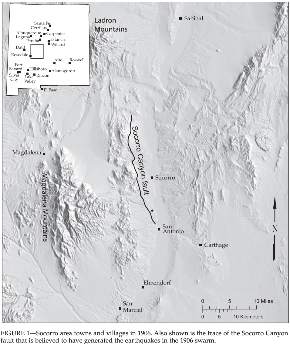
Source Sanford, 2008, https://geoinfo.nmt.edu/publications/periodicals/nmg/30/n4/nmg_v30_n4_p107.pdf
There is also evidence for past volcanic activity. Driving along the Rio Grande (the Interstate 25), various cones are passed which contain layers of lava flows of indeterminate age. And elsewhere there is a very clear sign: 50km east-southeast of Socorro is the Carrizozo lava flow, 5000 years old, 60 km long and with a volume of 4 km3. It is very clearly visible in the New Mexico map above. The Carrizozo flow overlays a much older lava flow. This is the second youngest lava flow in New Mexico – only the McCartys lava flow field 100 km northwest of Socorro, of similar size, is younger. It seems New Mexico does infrequent but rather large effusive eruptions.
The Carrizozo lava flow is well worth a visit. There is a good tourist trail across the flow. But beware. The long road from a little south of Socorro across the basins to the Carrizozo lave flow eruption was bendy and dangerous. The worst traffic accident I have seen was on this road. It has been redesigned since and is now easier to drive, but please do take care on the journey. Patient driving may take longer – but it also makes you live longer.
There is in fact a volcanic legacy across New Mexico. Some distance west and southwest of Socorro is a large volcanic plateau stretching from Datil (a very small town halfway to Arizona) to Las Cruces (a rather larger city on the Rio Grande), dated to 25 to 40 million years ago (the plateau, not the city). It includes some 20 large calderas, much eroded after the passage of so much time. At the time, much of the southwest US was in volcanic turmoil with many ignimbrite eruptions. In the north of New Mexico is a line of volcanic features including craters, calderas and cones, stretching across the state. This activity is less than 5 million years old. This includes the Taos volcanic field, the largest one in the Rio Grande rift with lava and cinder cones, and the Valles Caldera, a 20-km wide, 1 million year old caldera. At the southwest end of this line of activity lies the Zuni-Bandera lava flow, which includes the 40-km long McCartys flow, active only 3000 years ago. The dry climate has limited erosion: the lava seems even younger than it is. But erosion is not non-existent: elsewhere, in the northwest New Mexico, an ancient volcanic feeder pipe and dike is now sitting on the surface as famous Shiprock.
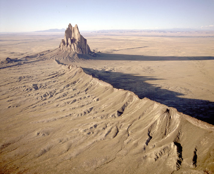
Shiprock. Source: https://geoinfo.nmt.edu/tour/landmarks/shiprock/home.html

Source and further information: https://nmnaturalhistory.org/online-exhibits-geoscience/volcanoes-new-mexico
One of the old volcanoes of the old Datil-Las Cruces plateau lies just west of Socorro. It is of course named the Socorro caldera. It erupted 32 million years ago and formed a tuff layer that covered the entire region from Socorro to the Magdalena mountains. There were 5 caldera eruptions in the region: the Socorro caldera is the oldest. The next four eruptions between 31 and 27 million years agooccurred progressively further to the southwest, away from Socorro. The eruptions never progressed east of Socorro: they did not cross the (future) Rio Grande. This was presumably because of the presence of the North American craton. The eruptiopns coincided with the onset of the Rio Grande rifting. The cause of the rifting was -as always- in the Pacific ocean where the Farallon plate was being overridden by the westward moving North American continent.
Once the Rio Grande rifting started, Socorro developed a bit of a problem. The rifting was much larger to the north and than to the south. Socorro had to cover the difference. This happened through the so-called ‘Socorro accommodation zone’ which runs east to northeast, a shear zone which allows the two regions to rift differently. In places it runs along route 60. (Route 60 is the old alternative to Route 66, across the mountains into Arizona. It is one reason for the growth of Socorro: people in old cars traveling from the east coast to California getting stuck on the first significant incline on the road and having to remain in Socorro.) This shear zone is a continuous weakness: every few million years a little magma leaks upward through it. This has happened ever since the time of the Socorro caldera. It connects the past with the present.
Arrival
The present is different from the past, though. The Rio Grande valley is as old at the African rift valley but it seems to have stalled. Rifting is much slower than it has been. As the rifting slowed down, so did the tectonic and volcanic activity. The rift has gone to sleep. But why is this sleep in the already sleepy town of Socorro so restless? Why the dreaming and the jitter of the earthquake activity? In a state riddled with faults and rift, why Socorro?
This question began to be asked in the 1960’s. In 1959, Allen Sanford had borrowed a seismograph from the Carnegie Institute and deployed it at his institution, New Mexico Tech where he had taken up a position two years earlier. The instrument detected a staggering 49 micro-quakes within three days. This asked for more, so he obtained his own instrument and started measuring. By 1962, it had become clear that this was not a fluke. Sanford found swarms of such events, averaging to some 600 micro-earthquakes per year. This was the first real study of micro-earthquakes. Up to that point, seismographs were used to detect larger, distant earthquakes – in fact Sanford had studied under Richter who made a career and a scale out of such work. Sanford instead selected events where the P and S waves arrived within a few seconds of each other, which allowed him to detect small but local events. Nowadays this is common, of course. A micro-earthquake was defined as an event with magnitude less than 3. Modern seismographs go much lower than this, but at the time, this was revolutionary.
In the early 1960’s Sanford also found that the small signals were commonly followed by another small but sharp signal, 2.5 to 5 seconds later. It was as if he saw an echo, and he interpreted this as a reflection of the seismic waves from a deeper layer in the crust. The earthquakes themselves originated from 5 to 10 km depth, but the reflection was at 18 km. This was in the middle of the crust and was clearly not the crust-mantle connection. There was something embedded in the crust.
In 1977, after many years of work involving quite a few co-authors, Sanford published the interpretation: there was a sill of magma between 18 and 20 km below the Socorro region, extending over a large area of at least 1700 km2. This interpretation had become plausible for at least a decade before, but science goes slow: all evidence for and against has to be collected and considered. The depth and location of the layer came from the time delay between the direct and reflected wave. Sanford showed that the reflection came only from S waves even though they were detected both as S and P waves. In the reflection, an S wave (shear wave) can remain an S wave or it can be converted into a P wave, so that both were observed. But the arrival times showed that the original P waves had been not or little reflected: the detected P waves had come from converted S waves. This meant that the reflecting layer had low strength: it was like a fluid. The high geothermal heat in the region indicated this fluid was magma, not water. The melt fraction in the rock could still be low: a few per cent might suffice.
More data showed that the layer with the melt was not thick, at less than 1 km. This information came from distant earthquakes: P waves travel slower through a melt, but these signals arrived with very little delay. So the layer was a thin one. The thickness of the layer was estimated at 130 meters, consisting of 70 meters of melt sitting above 60 meters of a crystal mush. The 18-km depth was quite uniform across the extent of the sill. There was a slight dip northward, but no more than 6 degrees. This indicated that the magma sill was capped by a layer that acted as an impermeable barrier. However, in a few places there was evidence for small amounts of magma closer to the surface which appeared to have passed through this cap.
The seismic activity found around Socorro was likely related to this magma sill. The region of enhanced earthquake activity measured around 5000 km2. As measurements improved, the magma sill was shown to have a similar extent. By 1977, it was measured at 3400 km2, extending 80 km north-south and 50 km east-west. It is elongated along the Rio Grande rift valley. Although Socorro is located at its southern edge, it is now called the Socorro Magma Body. (It is named after Socorro county rather than the town.) At 440 km3, it is the largest known (liquid) magma sill in the US and the second largest known in the world. Who would have thought that the small adobe settlement of Socorro was hiding such a secret. The ‘M’ on M Mountain no longer stands for ‘Mines’. It now proclaims ‘here lies magma’!
The similarity between the seismic anomaly and the magma sill indicated that the magma is putting pressure on the rock layers above it. Was there other evidence for this?
Growth
Yes, there was, and it too was first seen in the 1970’s. Leveling surveys along the Rio Grande had been carried out in 1912 and in 1959, with a later survey in 1980. Comparing the first two in the region of the magma body showed changes: the region had been uplifted by 9 cm, or 2.3 mm per year. The 1980 data showed that this had continued at a rate of 1.8 mm/yr. The area between Socorro and Bernardo was inflating! This inflation could of course explain the seismicity. Was the Socorro Magma Body perhaps growing?
InSAR measurements have since confirmed the inflation. The figure shows the results from the leveling (the green line) and InSAR measurements taken between 2000 and 2006 (the blue dots). The inflation over the 50 km range of the Socorro Mama Body is peaking at 2 mm/yr, consistent with what was found 50 years earlier. The inflation has occurred at a constant rate over at least the past century.

Source: Pearse & Fialko 2010, https://agupubs.onlinelibrary.wiley.com/doi/full/10.1029/2009JB006592

Source: Reiter et al. 2010, Lithosphere, 2, 447
This inflation fits the earthquake pattern. The earthquakes have occured near Socorro and near Bernardo, which is on the edges of the Magma body. The inflation puts more stress in these regions where it arches most strongly, which is not ate the centre. Thus, the earthquakes fit the inflation pattern.
Based on the rate of inflation and the thickness of the Socorro Magma Body, the age of the sill would be 104 to 105yr. Any more would cause problems. At this rate of inflation, a rock formation of 100,000 years old would be 200 meters uplifted. This would be obvious, in that the Rio Grande valley would show the raised blocks well above the level of the valley to the north and south. The Rio Grande would have a problem getting around it. But this is not seen. Terraces emplaced in the past 100,000 years or thereabout are measured at 30-50 meters above their expected height. This suggests the magma is around 10,000 years old. There are some indications for a larger uplift in much older deposits, dating to a few million years ago, but not in more recent rocks. The Socorro Magma Body appears to be a relative recent structure, at least compared to the most recent lava flows in the region which date to 3 or 4 million years ago.
With an age of 10,000 years and a magma volume of 433 km3, the magma supply rate becomes about 0.05 km3/yr, or 1-1.5 m3/s. That is a reasonable rate, but it presents a problem. Once emplaced, the magma in the sill will begin to cool. A sill of this thickness will solidify at a rate of a few centimeters per year. That sounds small, but it is ten times larger than the rate of magma influx. The magma could therefore not remain liquid. But the seismic data shows that it is liquid. A much higher rate of influx could have kept the magma liquid, but is ruled out by the amount of inflation. Perhaps the Socorro Magma Body is much more recent, at only 1000 yr, but this would require a very high inflow rate. It seems that the Socorro Magma Body should not exist.
The heat is on

There is however more evidence for the presence of the magma body. Borehole measurements in the region have shown a high heat flux coming up, measured at 96mW/m2. In the region just outside the magma body, the heat flux is 82mW/m2. A little of the difference comes from a lightly shallower Moho in the Ro Grande rift underneath the Socorro Magma Body but that can only explain a difference of 3mW/m2. The rest requires a heat source in the crust. Something is producing some 10 mW/m2, at the location of the Socorro Magma Body.
Let’s assume that this heat comes from solidification of the magma. The latent heat is very roughly 100kJ/kg. Per second per square meter, 10-7 kg of magma could solidify. Over a year that makes 3 kg/m2 which corresponds to a layer of 1 mm thick. The magma is 70 meters thick with an additional 60 meters that has crystallized. At this rate, that layer would have taken 60,000 years to form. This is a very rough calculation, but it gives a result not dissimilar to the number of years that the magma body would have taken to form at the current rate of inflation. So the Socorro Magma Body is quite happily existing and is not solidifying as fast as had been assumed. The magma body is not a stale one.
Socorro Questions

But this raised other issues. The heat takes much longer than 10,000 years to reach the surface form a depth of 18 km. It may take a million years to do so. It is not obvious that the excess ground heat and the Socorro Magma Body are related! The current heat may be much older: it could even date from the previous epoch of volcanic activity here, 4 million years ago. That is also suggested by calculations of the total amount of excess heat in the crust, which is considerably more than the excess heat introduced by the Socorro Magma Body. Perhaps there have been multiple episodes of magma injection over the past million years or more.
It is also possible that every now and then the magma rises much higher up in the crust and that this carries the heat upward. The old work from Sanford already suggested the presence of shallower magma pockets. That would reconcile the crustal and magma heat, and would allow the Socorro Magma Body to be responsible for the current heat flux at the surface.
Science is never easy. It has to consider all options and find out which is correct. That process is not finished here: there is too much we do not know.
Is the inflow really continuous or has it been episodic? A bit of both, perhaps. A 26,000 year old terrace showed the same uplift as a 600,000 year old one. A 3,000 year old one showed little uplift compared to the current situation. This suggested that the inflation began less than 26,000 years ago and had ended by 3,000 years ago. The current inflation would be a recent resurgence, which could even be only 100 years old.
InSAR has revealed another mystery. While the ground above the Socorro Magma Body is inflating, the region around it is going down. It is called a sombrero pattern. But what is causing the deflation? One recent suggestion is that there is a region of weak crust surrounding the magma body. That could be a mush layer with partly solidified magma. If the pressure in the magma body increases, the weak layer responds relatively quickly by rising. But if the inflation had stopped 3,000 years ago, there could have been deflation over that period. Because the weak crust reacts fast to the recent resurgence, the area above would now be inflating while the surrounding area is not yet aware and is still responding to the deflation. The result is inflation above the magma body but deflation in a region around it. A similar sombrero can happen if the magma body itself rises and indeed it is often seen before an eruption. But a weak zone (mush?) would allow the same thing to happen where the magma remains at its original depth. This was shown recently by a New Mexico Tech PhD student, Grant Block.
Did you get all that? Now please take the exam.

Eruption?
There is one other similar magma body known on Earth. It is the Altiplano-Puna Magma Body, in South America. It is larger than the Socorro one. The region around this body also shows the same sombrero inflation/deflation pattern. There is a difference, though, in that the Altiplano one is located in a volcanically active region. Socorro, on the other hand, has not had eruptions for a very long time.Does the Socorro Magma Body presage eruptions? Should we expect volcanic eruptions near Socorro? If the inflation has indeed been going for 10,000 years, than the immediate risk seems very small. But the earthquake activity and the possible resumption of inflation in the past centuries could be taken as a warning. There is little indication that the magma is moving up: the magma body is a safe 18 km below ground and seems inclined to stay there. But there is inflow and the ground is shaking. Something could give way.
The last two eruptions in New Mexico were effusive and large. It is plausible they were fed from magma chambers similar to the Socorro Magma Body.
Perhaps one day this desert town will experience its second Trinity Day when a volcanic version of Oppenheimer declares death and destruction, ending up creating a tourist site. But until that day, let this sleepy town with its big secret lie. Just remember not to speed in front of the diner.
Albert, February 2024
https://geoinfo.nmt.edu/publications/periodicals/earthmatters/19/n1/em_v19_n1.pdf
The Rio Grande – home of the largest cover-up in the US


Fascinating! Thanks Albert!
Nice one Albert! Now, why do I get the impression that you have at some point had a brief chat with the local officer outside a certain diner?
I did have a chat with him once when he stopped me for the crime of walking and wanted to know what had happened to my car. (In reality, he knew who I was and was offering help. There was nothing wrong with my car – I just preferred walking.)
Ah, that crime. I committed the same crime once in California with the same outcome. Apparently, if you’re not dressed for a jog and you’re not walking a dog, it must mean that your car broke down.
Thanks Albert for this wonderful article.
Aided by annular repainting…
Do they paint rings around it? (sorry, I’ll get my coat). 🙂
Oops. I blame the students, of course
Then of course there’s the stress which is not ate the centre.
Great essay on New Mexico’s surprising volcano! This extend the knowledge shared by Hector with his article on Mexico’s volcanoes.
I remember that Mexico has some shield volcanoes on the east side of the mountains. Do they have a similar tectonical setting like the Soccoro volcano? Sometimes subduction zones allow extension zones to develop which make “uncommon” basaltic volcanoes like Etna or Taal in the neighbourhood of classical subduction zone volcanoes with evolved magmas (Andesite to Rhyolite).
That is by Albert…
The article about Mexico in May 2023 was produced by Hector: https://www.volcanocafe.org/popocatepetl-and-the-trans-mexican-volcanic-belt/
There are some volcanoes close to the Gulf of Mexico which are Basaltic/Basanitic fields. Added to this the Trans Mexican Volcanic Belt hosts some shield fields. All of this reminds me to the extraordinary geological situation of the Socorro volcano with the 50km lava flow 5000 years ago.
Even Canada has some shield volcanoes: https://en.wikipedia.org/wiki/Category:Shield_volcanoes_of_Canada
They’re part of the North American volcanism, although they differ from the main subduction zone volcanism (F.e. Mt. Rainier, Lassen Peak, …).
My apologies. I thought you were talking about this article.
Speaking of Northern BC volcanoes, they are quite fascinating. The cause of them are theorized be caused by some form of rift, known as the Cordilleran Rift Zone: https://en.m.wikipedia.org/wiki/Northern_Cordilleran_Volcanic_Province (Wikipedia, I know)
It is also known as the Stikine volcanic belt, of which the majority of them are monogenetic volcanic fields, but there are a few large ones, like the bimodal Level Mountain shield, the Edziza volcanic complex and Hoodoo Mountain. It also contains the latest yet deadliest known eruption in Canada, the Tseax Cone (see-axe for pronunciation).
Yes, Canada can still surprise us like Mount St. Helens did 1980. Many people without volcano interest wouldn’t consider Canada as a volcano nation, but it’s one.
There are volcanoes along the Pacific Ocean that remind to the subduction zone volcanoes of the Andes. Behind them to the east follow complicated types of volcanism. The USA have the Great Basin, British Colombia has the Interior Plateau between the Pacific Mountain Chain and the Rocky Mountain Chain.
This geological setting causes different kinds of complicated volcanism from Mexico to Canada that are unlike the ideal type of Andes volcanoes.
Minor correction: “The most recent eruption in Canada took place at Lava Fork in northwestern B.C. about 150 years ago.” That is from the following article:https://chis.nrcan.gc.ca/volcano-volcan/can-vol-en.php.
According to Wikipeadia (that’s the best source for this volcano) the Lava Fork Volcano, which is also labeled as “The Volcano” (like Italy’s Vulcano), did a fluid lava eruption with a long lava flow that indeed reminds to Socorro’s 50km long lava flow:
“lengthy basaltic lava flows that flowed down steep granitic flanks of the mountain ridge on which The Volcano lies … The lava flows in total are about 22 km (14 mi) long”
GVP lists 1800 as the last confirmed eruption of Lava Fork
Well, that is true, after looking it up on a more reliable source: https://volcano.si.edu/volcano.cfm?vn=320090
Still though, the Tseax cone would’ve been harmless if it weren’t for the fact people are nearby. It proves that any eruption of any size can be deadly, based on a few factors.
(From this paper: https://www.researchgate.net/publication/340286977_The_age_of_the_Tseax_volcanic_eruption_British_Columbia_Canada)
This just shows you how immense the lava flow itself is and also buried a few villages along the way.
This is how the eruption would’ve gone (although the website it is attached to is a products site).
https://www.frontiersin.org/articles/10.3389/feart.2022.910451/full
Paper for the dynamics of the eruption and also a picture of what it would’ve looked like from a view:
https://www.volcanocafe.org/the-canadian-wilderness-eruption-tseax-volcano/
Some of the polygenetic shields are long-lived and voluminous. Edziza is the last major volcano to grow in this area and has a number of fresh, beautiful flows.
Most of the big volcanoes in this area look old and eroded, though. Edziza itself is relatively small, and partly eroded. Volcanoes elsewhere like Payún Matrú, Changbaishan or Halla are bigger, more impressive edifices of this kind, so I’ve never looked too much into the Canadian ones. Edgecumbe is curious, although it’s more of a plate boundary stratovolcano, than a back-arc alkaline polygenetic shield like Edziza.
I would agree it is smaller, it is quite interesting nonetheless. Edziza pretty much has most of everything a volcano could do, even lava lakes (mostly of aphyric trachyte, which is unusual) and got it from a geology map here:
https://ostrnrcan-dostrncan.canada.ca/entities/publication/9d57b0d6-138d-4c2d-a5e6-453ac094b3cd
I will warn. The file is quite big, but informative nonetheless.
https://science.gc.ca/site/science/en/educational-resources/history-geological-survey-canada-175-objects/147-mount-edziza-1992
And then another link to explain the geological history of the volcano, but it is a book you’d pay for to get the information.
These exam questions are easy. Clearly you just measure the temperature of the arriving seismic waves and the ones that pass through magma will be hotter than the ones that didn’t. As to the type of the plutonic body that’s obviously a “ball” as they named it after soccer. A second clue is that Pluto is also spherical.
What do I win? 🙂
You won a resit. The plutonic body os obviously the exasperated teacher who keeps shouting ‘SIT STILL!’ until all that comes out is ‘SILL!’
SILLy me!
The Rio Grande is a fascinating place, a relatively recent intra-plate rift akin to Baikal, just a lot smaller and slower. Whether it ever fully expands into a continental rift is doubtful.
I may be wrong on this but does the rift occur because the west coast of America is being stretched like taffy from frequent subduction events, and this is the point of most tension in the crust (or highest heat flow), or does the basin & range craton’s rotation play a part?
The rio grande rift appears to follow a zone of previous weakness:
https://www.researchgate.net/figure/Locations-of-Mexican-Borderland-rift-Late-Jurassic-Early-Cretaceous-and-Rio-Grande-rift_fig1_252280701
A pretty nice Geologyhub video on the origin of the LLSVPs and possibly life itself:
This piece helped simple-me gain more understanding –
https://www.bbc.com/future/article/20220510-why-are-there-continent-sized-blobs-in-the-deep-earth
Another wonderful story, this is treasure, thank you very much, Albert.
🌋🌋🌋🙏🏽🙏🏽🙏🏽
“The inflation over the 50 km range of the Socorro Mama Body is peaking at 2 mm/yr ”
That’s really lovely. She might well be gestating some new baby Earth!
I think this typo should remain!
A while back, I read up about Eldey, due to the recent quakes, and wrote here that it seemed nothing unusual, not a portent.
Of course, I was wrong! Far better brains say Eldey _might_ perform:
https://www-mbl-is.translate.goog/frettir/innlent/2024/02/20/bua_sig_undir_nedansjavargos/?_x_tr_sl=auto&_x_tr_tl=en&_x_tr_hl=en-US&_x_tr_pto=wapp
Lots of pillow lava, or another Surtsey? That brings back childhood memories, in monochrome, haha.
There are in fact three kinds of marine eruptions:
1. Distant Reykjanes Ridge with Pillow Lava like around 1990
2. Real Eldey eruptions of small Surtseyan type (VEI1-2?), they can send ash to Keflavik airport
3. Reykjanes Surtseyan or Amphibious eruptions on the westend of the peninsula close to Gunnuhver
The Third type of eruptions can do moderate Surtseyan eruptions around VEI3 and can send ash to Reykjavik. They can be as strong as Grimsvötn’s average eruptions.
WANDY – “We Are Not Dead Yet” was what the Ingenuity team said to themselves for years every time they escaped the numerous proposed project cancellations prior to the launch of Perseverance.
Somehow despite a crash landing and the long distance tossing of an entire blade, Ingenuity landed upright and gets to conduct its own accident investigation. WANDY!
At https://www.quantamagazine.org/inside-scientists-life-saving-prediction-of-the-iceland-eruption-20240220/ “Inside Scientists’ Life-Saving Prediction of the Iceland Eruption”.
Great article
Hi Albert,
Thanks for the very interesting article which took me back to two weeks I spent in New Mexico a few years ago.
It is one of my favorite places in the US and there are quite a lot of volcanic “remains” worth visiting. One that comes to mind is the El Malpais lava flow just south of Grants.
There are many other geologically interesting places as well which makes it a place to recommend to everybody here…
Thanks for the article Albert.
I’ve been having a look at the GPS around Svartsengi. From the current slope on the curve, if it continues with the same pattern, I estimate eruption from 5-6 days onwards. On the 14th, IMO stated that around 2 million m3 had influxed into the sill since the eruption stopped and eruption becomes more likely at 10 million m3. The puts it at 25 days from the end of the last eruption to the likelihood of the next, so from the 26th onwards.
Sorry, The IMO data suggests later than that, around March 5th.
IMO said recently the end of this month or early next month.
The dormant period of 25 days was constant during the first dwo eruptions and it looks as if we can rely on this timespan more or less. On the other hand I see a dangerous development in the decreasing warning time before the onset of the eruption. I’ve read (forgotten where) that the warning time has been reduced from 90 to 30 minutes. If this trend continues, the eruptions will occure more suddenly than previously. 30-90 minutes is Hekla style, but the tendency looks as if Grindavik’s volcano is going to undermatch Hekla in future.
After 23 days they should ban completely all seven zones in the hazard assessment map for any human beings. Eruption fissures can plop up like a flash without warning, and massive fast lava flows can storm in any direction.
There is no guarantee that the volcano(es) will continue to behave in the same way. Ditto that the ground will not give way (there are subsurface cracks).
Barely any earthquakes though. The sill is filling up but the dike swarm is not too stressed. It may take longer this time.
I had assumed that the lack of quakes was because the area of the dyke had possibly become more ductile, However would the almost total lack of quakes, if it continues, mean that an eruption could occur with almost no warning at all in the dyke area? I am actually starting to feel very concerned now about the lack of quakes, which is a totally different scenario from the last pre-eruption period.
Oh and a very belated many thanks to Albert for this fascinating article which I have just read after a good few days away.
It’s a reasonable thought. Although my intuition tells me that we will see the fissure line as well as the west side of Fagradalsfjall flare with earthquakes as the eruption approaches. The recent event of Kilauea has strengthened my faith in earthquakes over deformation as a precursor to a volcanic event.
I have the impression that the system is still building up. It could lead to a future with a sustaining vent, maybe some kind of lava lake that comes up and down every four weeks. Below the surface the ground is heating up, and the channels from the sill to the surface should become increasingly open. Then we’ll see the heartbeat of the sill/magma chamber directly on the surface.
The inflation-inferred inflow rate to the sill might not be sufficient to keep it from solidifying, but that represents the net inflow. If magma is convecting into the sill, cooling, and most of it sinking back down the deep feeder again, the heat flow into the sill may be considerably higher than you’d expect based only on the net mass flow into the sill.
I was thinking the same, and also that some of its magma could have gone to deep dike intrusions, to the Jornada del Muerto and Carrizozo lava fields, and other stuff.
If we classify volcanoes by frequency of eruptions, many Mexican, US and Canadian volcanoes belong to a similar type of volcano like France’s Auvergne, German Eifel, Czech Eger Graben, Italy’s Toskana volcacnoes and several more in the world with eruptions every 10,000 years.
Does Socorro belong to this type or has it erupted more frequently than once every 10,000 years?
Cat Hills shield volcano formed about 100,000 years ago, then there’s Jornada del Muerto shield that sources say is 760,000 years but this is incorrect and comes from a statement in an article that it is younger than the Brunhes–Matuyama reversal, but in appearance is far younger than the Cat Hills. Then there’s Carrizozo which is abut 5000 years old. Other shields in the immediate area of Socorro are older looking than Cat Hills. So not very vigorous volcanism, but eruptions are individually huge.
How can we distinguish between extinct monogenetic shields and recurring shields on this timescales? Many Volcano Lists only include volcanoes that erupted during Holocene. Volcanoes that erupted 100,000 years ago can easily be considered as extinct, even if they erupt again in future.
In my posting above I refered to volcanoes that erupt every app. 10,000 years. What longer recurrence times than this are possible? If I’m right the Yellowstone is an example, there we know that it will erupt again, but the last magmatic eruption was 70,000 years ago. In Italy the Sabatini volcano and Tuscany’s Monte Amiata are European examples of possible longterm recurring volcanoes. Even Iceland may have some very longterm volcanoes that erupted before Holocene and will erupt again.
Yes, Yellowstone is a clear example, although an odd case. It has been dormant for 70,000 years and the previous dormancy was 30,000 years. Valles, the smaller cousin of Yellowstone, was dormant for 500,000 years between its last two eruptions, going from memory. But most volcanoes are not well studied enough to know with precision how long they have been dormant.
I’m not sure how long a volcano can go dormant for. I can think right now of Ol Doinyo Gelai, there are a number of geochronologic determinations of the strati-graphically youngest lavas of this Tanzanian volcano which show it went dormant 1,100,000 years ago, after rapid construction of the edifice. But then in 2007 it did a non-eruptive dike intrusion that was observed with InSAR. But I wouldn’t be surprised if some volcanoes can go dormant for millions of years. I can recall one submarine Hawaiian volcano that may have reactivated after 10 million years of “sleep”, from about 42 Ma to 32 Ma, but there is no good enough data to know if this dormancy was absolute, or what was the nature of the reactivation.
Didn’t a volcano on Gran Canaria go dormant for several million years in between building the island and having a late series of eruptions?
Yes, Gran Canaria was largely dormant between 10 Ma and 5 Ma, though I’m not sure this quiet was absolute or not since not every single flow has been dated. The reactivation seemingly used the same conduit, as the summit popped up in the same place it was during the main building phase. Some of the Late Cenozoic eruptions are probably separated by intervals of well over 10,000 years too.
It sucks that North America is in a quiet era, I would love making cross country road trips to view fantastic lava flows.
There are many volcanoes in Canada and USA-48 that either do nothing or do big. Unlike the Strombolian-Vulcanian volcanoes of Mexico, Costa Rica, Equador, Peru and Chile that never sleep, but rarely get into the news.
Popocatepetl is in North America 🙂
I think Santa Maria, Pacaya and Fuego are too, although they might be south of the plate boundary.
Drove through the area by coincidence just last week during a brief roadtrip (living in Central Europe otherwise). As you say, it´s a surreal and beautiful landscape there. Especially White Sands!
Never would I have expected there to be some magmatic action going on below the surface – the land itself doesn’t give it away at all! At first glance only the gypsum sand was peculiar from a geologic perspective.
Thanks a lot for all the background and putting the info together, Albert! Would be interesting to know when it flares up next time. Shame it’s unlikely to happen in our lifetimes..
Two or 3 years ago, I watched NASA fly their big 747 from Edwards up over CA, loop around, come along the Shasta to Craters of the Moon, in Idaho, then turn and head south for New Mexico, looping towards the west once again, heading over specific Arizona volcanic areas. If was obvious that the aircraft was loaded with volcanic sensors and they were obtaining a ton of data. See https://www.jpl.nasa.gov/news/nasa-sensors-provide-safe-platform-for-volcano-studies as a typical writeup on this. NASA employed several surveillance aircraft, including one 747 they chartered. When flying over New Mexico, they were west of the Valles Caldera, and then turned west, near the Lucero Volcanic Field
The one 747 flight I watched was over 7 hours long, so I stayed up most the night watching on Flight Radar, the aircraft flew up to 48,000 ft altitude which is the maximum for the 747 aircraft. See https://www.flightradar24.com/44.76,-115.04/5.
NASA is aware of a lot of things going on volcanically, but unfortunately not all that much is made public.
Yes, New Mexico is one location being carefully watched.
I think NASA do freedom of info type requests – might need to be a US citizen (dunno)
Just ask them what the plans are for these data!
Maybe digital elevation models? I’m not sure what else they could measure flying over dormant volcanoes.
I’m presuming if the magma body does eventually erupt, it would form a new basaltic volcanic field?
That seems plausible, as recent eruptions have been of this type. Cinder cones are common further north and in Arizona, but I don’t recall seeing them around Socorro
The Carrizozo lava flow reminds to Holohraun 2014-2015 or Mauna Loa 1950, but bigger. Would the precursory signs be similar to our familiar volcanoes or would an eruption happen more suddenly like Hekla? How similar are those “continental” basaltic eruptions to Hot Spot basaltic eruptions?
Probably a fast start but mostly slow, they are shield forming eruptions. I imagine the final push to the surface is quite fast if some of the lava contains xenoliths but then after watching the 2021 eruption of Fagradalsfjall, it is not impossible that the feeder dike also rises slowly too. I guess the fact that only single vents are visible probably means the original fissures were short to begin with, so the peak rate at the start was probably relatively low but fountains might have been tall.
The flows are 50 km long. That requires high eruption rates
If it happened comparably to the Canadian eruptions mentioned above, then it would have commenced like a lava flash flood from the mountains. The Canadian vents happened on high altitudes and used slopes to get speed. Did the Carizozo lava flow profited from a similar physical geography?
A moderate eruption rate would possibly get a similar result, if it lasts long enough and makes long lava tubes. F.e. Mauna Loa 1859 had a moderate eruption rate, but lasted longer (300 days) than 1950 (22 days) and made a longer lava flow that encirceled a quarter of Hualalai. Both had the same volume of 0.38km³.
The Canadian and the Carrizozo lava flows reminds me to an “all in one” eruption of the Reykjanes Fires, but in mountainous landscape. Maybe the rifting of Rio Grande works a bit like the MAR on Iceland, even if it in the end may become a failing rift as the North Sea rifts.
No it requires sustained flows in tubes, the lava flows that nearly crossed the road at Pahoa in 2014 (already nearly 10 years ago now) were never fed at more than 10 m3/s and likely closer to half that, and still flowed 24 km. The Aila’au flows to the north and 600 years earlier made it 45 km, and the second stage of the Mauna Loa 1859 flows also flowed to the ocean, and with similar effusion rate. The slope of the north flank of Kilauea and the ERZ is very shallow, steeper than where the Carrizozo flow is but comparable. At best the Carrizozo lava was 10 m3/s, but not higher than that or it would turn to a’a even on the flat ground, as we have seen from the recent eruptions in Iceland.
https://www.academia.edu/63171586/Emplacement_of_the_75_km_long_Carrizozo_lava_flow_field_south_central_New_Mexico
This article suggests it is somewhat similar to the Kupaianaha lava flow from Kīlauea during the Pu’u O’o era, which means it might’ve been slow, but would’ve started strong.
https://www.academia.edu/90674314/Improved_Topography_of_the_Carrizozo_Lava_Flow_Implications_for_Emplacement_Conditions
And another article on the same flow, suggesting this is quite different from the Tseax Cones mentioned above.
On that same note, here is a picture of the source of the lava-
It is from the website here: https://www.nmnaturalhistory.org/volcanoes/carrizozo-lava-flow
It suggests that the cinder cone likely formed during the final phases of the long eruption.
Kupaianaha was just a flank vent of Pu’u O’o, it was named because it was unexpected (and sort of means the same in translation) but the same thing happened again like 20 more times, including another fissure in the same place as Kupaianaha. I tend to just call it all Pu’u O’o now.
The thing about all the flank vents is they were shallow and branched off of the deeper conduit of Pu’u O’o. The Carrizozo vent would be like Pu’u O’o, probably with a lava lake or similar, and lava either flowed out of that or satellite vents nearby. But only the main cone has a deep connection.
I guess they probably mean tube fed pahoehoe being fed for years.
Thanks for the Article Zach!
There I’ve found that the Carrizo lava flow field “is a compound, tube-fed, pa-hoehoe flow field”. So similar to Kilauea’s longterm eruptions and on (dwarf scale) the Fagra I eruption 2020. They haven’t found a lava channel, so assume that there was a major lava tunnel.
The viscosity was between Kilauea and Etna. They say that if the behaviour of Kupaianaha was a model for Carrizo (5m³/second), then the duration of the eruption was 26-27 years. They assume that this long duration was the main factor for the long lava flow. So it wasn’t a lava flash flood, but a longterm slow and steady “tourist eruption” for volcano loving native American tourists.
At the same time the whole eruption was accompanied by mild explosive (Strombolian) activity at the Little Black Peak
Very likely by the Pre-Pueblo peoples, since the Apache peoples would’ve came later:
https://en.m.wikipedia.org/wiki/History_of_New_Mexico (not the best source, so check the sources in there)
Which leads to wonder what mythology would be created from said eruption.
It would be interesting to know how the historical witnesses narrated the mysterious about this 75km long (according to the study) lava flow. Ancient people weren’t more stupid than we are today. They just didn’t know as much as we do, but they were as intelligent as us. Before knowledge exploded, humans had to rely on wisdom. Today it’s the opposite … there is a giant knowledge in the world, but little wisdom.
They were smart enough to live near water. Without horses, people were dependent on rivers or water coming down the mountains. There are mountains south of the flow but the flow itself seems to be in a flatter basin without permanent water. So I expect that the region was not occupied
Even though they probably never saw the Carrizozo eruption, they did see the eruption of Sunset Crater:
https://www.researchgate.net/publication/358175278_Talking_with_a_Volcano_Native_American_Perspectives_on_the_Eruption_of_Sunset_Crater_Arizona
There was a specific part where they talk about how spiritual leaders put corn on lava flows, which sound not too unlike people putting bananas on the lava flows of Fagradalsfjall 1.
I feel like the only reason absolutely no one would go there for 30 years is actually because of the eruption, which would infer awareness of it. If people are like us now curiosity would have got to some people.
https://www.researchgate.net/publication/222888938_Variable_effects_of_cinder-cone_eruptions_on_prehistoric_agrarian_human_populations_in_the_American_southwest
No wonder. It is pretty explosive, a VEI 4 on the scale I think, subplinian. There would’ve been darkness for a bit in the area of the ash.
The eruption was a longterm slow and steady eruption. Not really dangerous. Nothing to worry about for humans.
Carrizozo is indeed slow and steady, therefore safe, Sunset Crater is another story. A violent VEI-4 eruption, larger than most known cinder cone eruptions, would’ve been very dangerous and terrifying. Makes even Tseax cone looked like a firecracker compared to this one. I wouldn’t doubt if there was some fatalities that occurred during this eruption in particular.
Thanks Albert. A city on top of a magma chamber must be an interesting place to live, if you know what you are sleeping on top of. They should do the cities on volcanoes conference there.
Underfloor heating is about £1000-15000 for a 10 square meter room so these people are getting a bargain.
Looking like eruption #4 is going to happen this coming week. I wonder if GVP will consider this whole thing a single long episodic eruption or a series of many eruptions? At least in Hawaii and as far as I know universally, an eruption needs to stop for 3 months AND erupt from a new intrusion after. Although there do appear to be quite a few exceptions to this rule.
Time would consider this a single eruption but each eruption at least so far has been a new dike as opposed to a repeatedly fountaining vent like Pu’u O’o or Fagradalsfjall I was. But if we get eruptions as often as every few weeks then I think there is a possibly of a more permanent vent forming, maybe how you get a large lava field like Arnarseturshraun.
Many effusive eruptions begin as fissure eruptions that later concentrate on a single vent. Are we going to see a similar development of Grindavik’s volcano? The decreasing warning time before the onset of the single eruptions indicates that the sill is slowly building an open channel towards the surface. There might once be an open chimney for rising magma. Then the monthly eruption may look like a lava lake eruption that spills out lava floods around.
During Fagradalsfjall I we observed a period of “Geysir” magma. There was an open chimney for magma that could easily and quickly rise to the surface if pressure was high enough. What Fagradalsfjall did several times per hour, might Svartsengi in future do every three to four weeks. Where is a likely location for such a recurring vent?
Different mechanics. The pulsing behaviour of Faggy had to with increasing viscosity in the conduit, trapping gas at the bottom. Whenever enough gas had accumulated, it broke through. Grindy has on-going magma inflow, just not enough to keep up with the outflow rates so it an only feed an intermittent eruption. Faggy had plenty of magma, just not (by this time) very buoyant
Is it a viscosity thing? The way I imagined it is the lava that falls back into the open vent is still fluid but is degassed and needs to sink down. The vent is not really big enough to do that continuously so pressure builds until convection is forced, which then leads to rapid degassing and the fountain. Its basically a geyser just with dissolved gas and not flash boiling. The degassed lava probably is a bit more viscous than the lava foam that fountains out but from the visuals we got it seems not significant.
Eventually the vent gets wide enough that it can convect continuously which is a lava lake. This happened at Pu’u O’o and Mauna Ulu, although apparently not at Fagradalsfjall, given that it stopped on its own without the magma supply itself stopping.
The gas has to move through the conduit, pushing the magma up with it. That gets suppressed. Viscosity is one aspect. In late stages, the magma is coole enough to act like a lid. The amount of gas certainly is also part of it though. Degassed magma has higher density and is less buoyant (unless very hot).
Just based on the visuals we have of that eruption it doesnt look like at any time did it get more viscous in a way that mattered if at all. If anything the lava erupted later on was more fluid than the earlier lava at the start, early flows barely made it to Natthagi and Meradalur without becoming rubbly a’a compared to flows in July and August which were pouring down cliffs into both valleys with the consistency of hot olive oil. That was in part due to effusion rate which was much higher in later episodes but still.
The lava in 2021 also might be the hottest lava erupted in Iceland in a long time, it started at 1190 C and was consistently 1220 C after April. Only Kilauea and Nyiragongo have lava this hot otherwise and both are notoriously low viscosity.
With Fagradalsfjall I took a wrong example. Maybe the Hawaii examples of Mauna Ulu and Puu Oo show better the tendency of eruption episodes to shift from a fissure behaviour towards a central vent.
Eruptions of Mauna Loa, Piton de La Fournaise and Holohraun do this tendency in one single large eruption, while episodic eruptions with interruptions divide this tendency between the many eruptions.
GVP shows well the development of the early Puu Oo stages: The first three fissure eruptions happened all the way from Napau to Kalalua. It was the fourth episode in June/July 1983 that began to concentrate activity on the vent which was later labeled “Puu Oo”. Will Svartsengi like this choose a central vent for the next years?
I had the impression that the upward force inside Fagra’s magma was too weak. Magma has to overcome gravity somehow, and Fagradalsfjall had little force for this. The 2021 eruption relied during the “Geysir” phase much on the aid by gas to push magma out. Without this force the eruption would have likely ended in May or June 2021.
The Geysir phase was a sign that the eruption was running out of puff. The buoyancy of the magma comes from temperature and gas content. As the magma rises, pressure reduces and volatiles come out of the solution, expand as gas and lower the density further so it keeps rising. This stopped happening because the magma had been degassed (and perhaps cooled a bit as well). But it was marginal: there was not enough gas to expel al magma in te conduit but enough to expel some.. What happened was first a pulsing behaviour where the eruption was strong for a few minutes every 20 minutes or so. That is the time the gas at the bottom needed to rise to the top of the conduit, carrying magma with it. Once that was done, the process repeated. The geysir phase started when this no longer worked and gas collected below the top of the conduit, unable to break through the degassed lid. After a while (hours) enough gas would have collected to break out and an explosion occurs. This was all a sign of a waning eruption. The Grindy fires are very different. The magma chamber is a in a place with a weak rock lid, so a small amount of magma suffices to break out – enough to maintain an eruption for some hours but not weeks. Fagry had created a larger magma chamber in a much stronger place: once an exit was created, it could keep going for months, at least for the first eruption.
https://www.nature.com/articles/s41467-023-42569-9
The article on this dynamic of Fagradalsfjall 1. Seems to be more like volatiles at the cause, but viscosity is one factor…
Another volcano I’ve never heard about before: https://www.volcanodiscovery.com/gamalama/news/234853/Gamalama-Volcano-Volcanic-Ash-Advisory-VA-REPORTED-TO-FL070-MOV-W-AT-230340Z-OBS-VA-DTG-230350Z-to-7.html
Gamalama is on an island close to Halmahera (Indonesia). It does frequently VEI1 and 2 eruptions, sometimes VEI3. Andesite to Basaltic Andesite magma. It looks like a Strombolian volcano, often the size of Stromboli’s extraordinary irregular eruptions.
Per IMO, 5 million cubic metres of magma have accumulated under Svartsengi since the last eruption. The next eruption is thought to be likely when the volume reaches 8 – 13 million cubic metres, which at the current rate will be next week. It is considered most likely that the magma will move from Svartsengi to the Sundhnúk crater series and that an eruption will occur in the area between Stóra-Scógfell and Hagafell.
The advance warning for the eruption may be less than 30 minutes, if any. If magma migrates to a location closer to Grindavík, there should be some seismic activity along with it.
Source: https://www.ruv.is/frettir/innlent/2024-02-23-fyrirvari-naesta-goss-gaeti-verid-innan-vid-30-minutur-405703
The article does not give a date for the source data for the modelling.
It stated February 22nd in the figure description. However, unfortunately there are other discrepancies between the description and legend, so I’m not sure how reliable the date is. According to the legend, the current inflation is marked by the purple line, but in the description it is red. I suspect the legend is correct and the error is in the description.
It might be the 20th (the last data point) in IMO’s own article.
https://en.vedur.is/about-imo/news/a-seismic-swarm-started-north-of-grindavik-last-night
Looking at the graph in IMO’s article, the volume of inflation occurring before an event (graben formation or eruption) is decreasing so far.
Does this mean that not all magma is erupted or does it mean that less pressure is needed (or both)?
The graph shows that the volume needed for an episode has decreased:
1. December 17 million m³
2. January 11 million m³
3. February 8 million m³
If this trend continues, the next eruption will be before the volume of 8 million is reached.
Before the onset of the last eruption, a serious of quakes centred around pretty much the same general area, about 20 seconds to a minute apart, started up. Half an hour later it erupted. So it would be a wise precaution to have any workers closely spaced next to each other over the next week or two, with constant 5-10 minute radio communication ongoing so that they can get out of there within 10 minutes.
For the record I think it will erupt on the morning of the 29th.
Or we could just wait til the Blue Lagoon reopens.
It is open.
https://www.bluelagoon.com/reopening
Look to my coming at first light on the fifth day. At dawn, look to the east (of the Lagoon).
If the Svartsengi Fires are going to last for 30 years, we’re still in the opening period of the eruption. We still haven’t discovered how the main predominantly eruption will look like. Were the first three eruptions excemptions or the rule for the eruption style?
More and more frequently, earthquakes greater than 3 occur in Bárðarbunga.
IMO no longer writes his sentence stating that this is common.
Tectonic? Volcanic origin? Soon an eruption? Due to Grimstvön? Any thoughts?
Thks
I remember it was because of inflation of the system after Holuhraun. Kilauea erupted very fast after 2018 because most of the deflation was apparently permanent and so the magma chose to go straight up instead of lifting the caldera (well until late September last year when it found a new place to go. Bardarbunga is also a hotspot volcano getting fed a large supply of basaltic magma with two long rift zones but that is where the similarities end, Bardarbunga has a larger magma chamber, larger caldera, and a significantly lower magma supply. Holuhraun was also only half the story because an extra km3 stayed in the dike, so the real volume lost to the event was a bit over 2 km3, while at Kilauea the actual new intrusion in 2018 was relatively small and most of tbe way there was already in place.
Kilauea wasnt fully recovered but is already capable of eruptions again and now on its flanks too. Bardarbunga might still take a few decades or even a century to build up the magma lost to Holuhraun. And as it does so the caldera lid gets pushed up and makes earthquakes. It is the mag 5 quakes it did during the eruption in reverse basically.
🙂
Likely still liket to an after-eruption subsidence of the Caldera. Vesvuius still does earthquakes like this occasionally.
Sometimes Grimsvötn’s eruptions are preceded by earthquakes on Bardarbunga. It’s not easy to distinguish them from Bardarbunga’s own earthquakes.
A few in Hofsjokull too today which is a beast of a volcano.
I’m quite interested in those surrounding Herdurbreid. It’s being swarming there for years now but the place itself is out of the way, early Pleistocene. Guess it could just be rifty quakes but they seem to stop or congregate there.
Initial quakes far back were related to intrusion of a dike in the Kverkfjoll fissure swarm in the 2000s. More recent quakes were caused by the rifting at Holuhraun and the newest quakes in the past few years caused by Askja inflating. Herdubreid itself I dont think has been doing anything it was just caught in the crossfire. Until it erupts I assume the quakes are triggered by Askja which we know is now inflating and quite strongly at times.
Kverkfjoll never seems very active, despite being on the same rift. With that said the seismometer there looks like it is drowned in the flood of Barda and Askja quakes.
I was talking about the intrusions in the later 2000s at Upptypingar, which Carl has talked about a long time back. Also perhaps it is because I am Australian where we are basically unphased by swearing unless it is intentional but I found out what Upptypingar translates to and it is very tame compared to what Carl made it sound like it should be… 🙂
This only applies for the swarms at Herdubreid before the 2010s though. After about 2012 and especially after 2014 the quakes were associated with Askja and Holuhraun. But none of the swarms look magmatic, more like faults responding to Askja inflating and formerly to the Holuhraun rift opening.
I think B is still recharging, slowly, it takes a while.
After the relatively silent years around 2020, quake activity is picking up a little, also deeper. Signs for an eminent eruption would be much more clear.
Source
The new small quakes near Sundanukar this morning (PST) has caught my attention. https://en.vedur.is/earthquakes-and-volcanism/earthquakes/reykjanespeninsula/
A large amount in the adjacent mountain range between it and Fagradalsfjall.
These triggered quakes are usually prominent in the days/week before an eruption. Pressure being put on the nearby crust by expansion of magma.
Interesting article in the science news today:
Strange seismic wave arrivals lead to discovery of overturned slab in the Mediterranean (Phys.org, 24 Feb)
If the interpretation is correct it means the subducted water is on the underside of the slab, not on top. And the cool slab is keeping any magma that is being generated stewing and bubbling and building up beneath it. If it starts breaking past the edge of the slab we might get to see some quite impressive eruptions in Spain or Morocco.
Unlikely any time soon, fortunately. A VEI 7 would not help the Iberian Peninsula, nor North Africa.
I wonder if it descends deep enough before that, if it might create something like the ‘hydro plume’ that is supposed to have made the Siberian Traps. Similar things are suggested for Paektu and the volcanoes of eastern Australia particularly the voluminous volcanism at Undara.
If that is the case then surely upwellings would occur either side of the slab where the heat escapes. How long these would take to reach the upper crust is anyone’s guess though.
I’m going to present an idea I’m not 100% sold on myself. If the Grindavik area eruptions become somewhat regular, Blue Lagoon could incorporate that into its business model and could make a pretty good ethical argument that it’s okay to do that.
With semi-regular eruptions they gain the ability to (arguably sufficiently) quantify risk. Most of us know people who enjoy recreation towards the more extreme end of the sports spectrum. I think there are probably black diamond ski runs in Europe and the U.S. that are riskier than staying at Blue Lagoon for a few nights while anticipating an eruption somewhere close by. Thousands of people every year pay up to $100k usd to climb mountains where the chance of a rather horrible death is one in five. There are not only people who would pay octuple or more Blue Lagoons usual rate for such an experience, it’s the only reason many of them would ever think of visiting Iceland. They would pay a premium for that thin flavor of risk (of being trapped by freaking lava) while sipping champagne in a lovely, steamy blue lagoon.
Again, I’m not fully sold on this being an acceptable plan. But if I was a sizable Blue Lagoon investor? I would say do it. Do it now.
Interesting quake patterns around Grindavik in the last week, there are the expected quakes at Sundhnjukagigar with a noticeable dense spot that is probably where the dikes start.
But there is also a line of quakes on the west side of Fagradalsfjall, which is not on the same line as the recent eruptions. There are actually vents along this line too, the lava of Boragarhraun that fills the bottom of Natthagakriki where the Fagradalsfjall trail starts, was erupted by a vent on Fagradalsfjall basically right in the middle of this new quake line.
Back when Fagradalsfjall was in the headlines one of the places that swarmed concurrently with the intrusions was the Sundhnjukagigar fissures… The quakes might all be tectonic initially but I think they are also early warnings to where activity will happen in the future. And given that this area is right inbetween two areas that are already active and appear to share the same magma source in the mantle I would bet on a sooner than later date for soemthign to happen here, before 2030.
I think that was also the southern end of the Fagadalsdjall dyke and the area where IMO initially predicted it was most likely to erupt.
Actually it is a little further west. The dyke cut through Borgarfjell.
If you go back and check that area, you’ll see that those quakes started in December, just a few days before the first eruption. After that eruption ended, the activity increased for a while, took a short break, then a brief swarm before the January eruption. Low level activity continued, with yet another swarm starting before the February eruption. Just like in December, which happened along the same section, activity increased right after the eruption ended.
The renewed activity now could mean that the next eruption is no more than 2-3 days away. It might also be a coincidence, but if the pattern repeats, these quakes could turn out to be a good precursor to look out for.
Yes that is also why I think it is an area of interest. I posted some quake maps on the last article about it and how Sundhnjukur was a major secondary quake source in the 2021 dike but it got drowned out a bit I think.
I guess until June, when Fagradalsfjall would be predicted to do something based on its last eruptions, we cant know if two systems can really be active so close at the same time. If Fagradalsfjall doesnt erupt in June or at least by August it would seem likely the volcanoes alternate.
New post is up! Tallis plays poker with volcanoes.
https://www.volcanocafe.org/volcanic-poker/
When I saw “Socorro” in the title, I was certain that the article would be about Socorro, the Mexican volcanic island with some pretty cool pantellerite lava flows! https://volcano.si.edu/volcano.cfm?vn=341021 (San Benedicto island, to the North, also has a really nice trachyte lava delta from the 1952 eruption)
Really interesting article nonetheless!