
Built on lava rock
What’s in a name. Would lava by any other name smell as sweet? Perhaps that is not the right question: lava is many things, but sweet-smelling it is not. It smells like a rose bush that was doused in some evil sulphurous pesticide and then put on fire. This rose also constantly explodes with a roar well above the legal maximum. No, Shakespeare’s rose is definitely the wrong analogy. The course of true lava never did run smooth.
But in geology, names are everything. The number of different minerals is staggering, and each has a different name which normally reflects its point of discovery rather than implying anything about the composition. Olivine has nothing to do with olives and perovskite is not a rock band. Do you know your cryolite from your kryptonite? How is your appetite for apatite? Studying geology must be like learning Inuit.
Volcanic rocks share this nomenclaturic nightmare. What on earth is rhyolite? What happened to komatiite? And what stuff is tuff? Even google can get confused: ask for amygdale, and it gives the right definition but images of something completely different. At least it knows not to show images of amygdala (which might require that you confirm your age). But for all of you who were confused but afraid to ask, here is help. This post gives all you need to know to understand the variety of rocks from lava, or at least help you speak like you do. Welcome to the club. We all bluffed our way into geological volcanology.
Lava is molten rock. At the end, it solidifies back into rock. So you should get back what you started with, right? Wrong. Just imagine a block of ice. Melt it, vaporize it, and let it condense and freeze, you may get snow. Both are solid water, but that is all they have in common. So too with rock, although with much more variety.
So let’s have a look at why not all lava is the same. For most of the images, if you click on them you will get full resolution. All the poor ones are from my own collection.
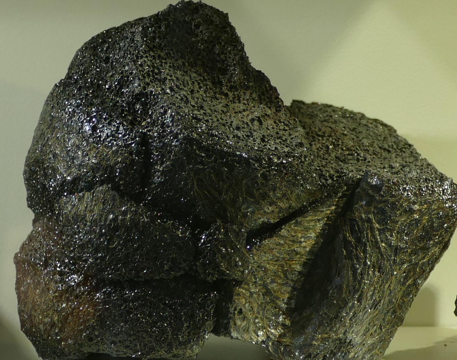
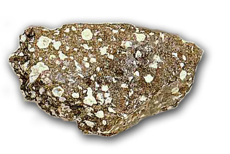
Basalt

Basalt. Photo by the author
The type specimen of volcanic rock is basalt. It is effectively mantle material, which was melted at the bottom of the crust, ejected from a convenient hole (also called a ‘volcano’), flowed downhill for a bit and solidified there. You are looking at displaced mantle material. Most of the ocean floor consists of this stuff. It is heavy because the mantle is made of denser material than the continental crust (if it weren’t, the crust would sink down like an overweight iceberg and continental existence would be short-lived). In practice, the density of basalt is close to 3000 kg per cubic meter. The continental crust is typically around 2700 kg per cubic meter.
Basalt is the ultimate volcanic rock. Why doesn’t every old lava flow look like this? There are a number of reasons why not all lavas are the same.
1. Temperature and viscosity
The first effect is that of temperature and viscosity. I know, that is two, but they are closely related. Lava can be compared to honey. Warm honey flows easily, but put it in the fridge for a few minutes and it becomes much less keen to spread out, even though it is still a liquid. Honey is actually quite a complex substance, even though it is mainly just sugar dissolved in water. The melting temperature is around 45 C (depending on the sugar concentration): above that temperature, it does indeed behave like sugar water. Below that temperature, it should freeze but it doesn’t, at least not until the temperature goes down to about 5 C. In between, it is a super-saturated liquid, where there is more sugar dissolved in the water than fits. The excess sugar forms crystals and this turns the honey into a mush. As it cools, more and more crystals form and the honey becomes stickier and stickier. Finally, it freezes. (Strictly speaking it doesn’t fully freeze until it reaches -50 C, but below 5 C it is so sticky you hardly notice the difference.) Now turn the temperature back up – and nothing happens until you reach the melting temperature. Funny honey. (When we call a loved one ‘honey’ one does wonder which characteristic of honey is intended. This expression is definitely open to interpretation.)
The stickiness is also called ‘viscosity’. Higher viscosity means stickier, i.e. more reluctant to move.
So in what way is lava like honey? Should I call my loved one ‘lava’ or would that get my fingers burned? Well, lava is also a mix of substances, and these have different melting temperatures. As lava cools, some substance may come out of the liquid and crystallize. As more and more crystals form, the lava becomes less runny and more sticky. And this gives rise to the two Hawaiian words used to describe lava flows: Pahoehoe and A’a.
Pahoehoe
A’a.
Pahoehoe is the thinner, runnier lava that happily covers large distances and creates smooth lava flow which afterwards you can walk on. It is the hot honey.
A’a is the sticky lava that refuses to go anywhere fast. It forms very uneven surfaces and is a nightmare to walk on (even after it has cooled enough). Its surface will shred your shoes – this is the one place on earth where high heels may give an advantage. A’a is the honey that has been kept too cool and really would have needed a few seconds in the microwave.
In Puna, the early eruption brought up lava that had been in storage for decades – perhaps centuries. Even though it had stayed warm (a kilometre of rock insulates pretty well), it did not stay hot. This became the sticky stuff, with high viscosity; this explains why the initial eruptions did not produce much in terms of lava flows. It built walls – not roads. Later, the new lava arrived and this was much hotter. The hot, new, all-running and dancing low-viscosity lava ran like runny honey and in no time covered huge swathes of country side.
Even though both are basalt, the two behaved very differently. Poor Puna.
2. Composition
Let me divert for a minute. Lava contains a mix of elements. The main ones are iron, magnesium, silicon, and some other things such as aluminium (called aluminum in Trump land, a spelling that was in use in the UK very briefly but was introduced to the US through the Webster dictionary of 1812.) Each of these forms minerals (mainly oxides), and each mineral has a different melting point. Hot magma contains all these elements and their minerals, although not always in the same ratios. But keep magma for a while in a storage facility (also called a magma chamber) and it begins to cool – very slowly. The first minerals to hit their melting points are iron and magnesium oxides: they form crystals and drop out of the solution. Beforehand, the magma was called mafic (for magnesium (never to be called magnesum) and iron). Now that iron and magnesium are becoming depleted, it is called andesite – you may remember this word from Puna’s infamous fissure number 17.
Store the magma for even longer, and you are left with mainly silicates, mixed with a few other elements (aluminium, calcium, sodium). This is called felsic lava (the word ‘silicic’ is also used). Rhyolite and dacite are of this form. Dacite has made an appearance in the recent Puna stories, albeit only found in deep (geothermal) drilling and not on the surface.
You can expect that this will form a sequence in temperature: mafic lavas are hotter and thus less viscous, andesite is cooler and stickier, and felsic lavas are positively cold (as lavas go) and nearly immovable. And for the most part, you would be right. Mafic flows – felsic stalls.

Rhyolite

Andesite
There are a few exceptions: sometimes magmas form by melting rocks that themselves already lack certain elements. For instance, imagine a rhyolitic magma chamber solidifying into rock. Long after, heat finds its way to the rock and melts it: the new magma will have the composition of rhyolite, but it could well be much hotter than usual, and therefore far less viscous. You can now get a rhyolitic pahoehoe, and this is for instance found along the Snake River in Trump land.
(Hint: if you want to impress your friends, using the term rhyolitic pahoehoe in Puna will do wonders. But avoid saying the andesitic a’a of Haleakala which could leave the impression that you had a drink too many.)
Iron makes the world look black. That is true in lavas as well: mafic basalt is dark to black, while the andesite is greyer and the rhyolite is a bright lava. Of course, add oxygen and over time iron turns red, like the soils of Oklahoma.
I should point out here that the world of lava is simpler than it used to be. A few billion years ago, the mantle was hotter than it is now and therefore lava was considerably hotter as well. This gave a type of lava that is ultra-mafic, an extremely magnesium-rich, which is called komatiite. They don’t make it anymore.
3. Rate of cooling
So temperature is important. But how quickly the temperature goes down is also relevant. Lava rocks that solidify fast look very different from ones that cool only slowly. The rate of cooling has three different effects.
(i) Shape
The first of these makes sense: if the cooling is fast, the flow patterns become fixed in the material. The ultimate example is pillow lava: these are erupted under water, and in consequence cool very rapidly (in the battle between the mid-oceanic ridges and the ocean, the lava has yet to win. Luckily loosing builds character and pillow lavas do have that. Although one could argue that winning builds more character.)
Pillow lavas
Petrified lava ripples
On land, cooling is slower. Thin flows on the surface cool faster than thick ones. In the picture, the difference between the thin flow in the foreground and the thicker ones in the background is notable! The former solidified fast enough that the flow patterns froze in.
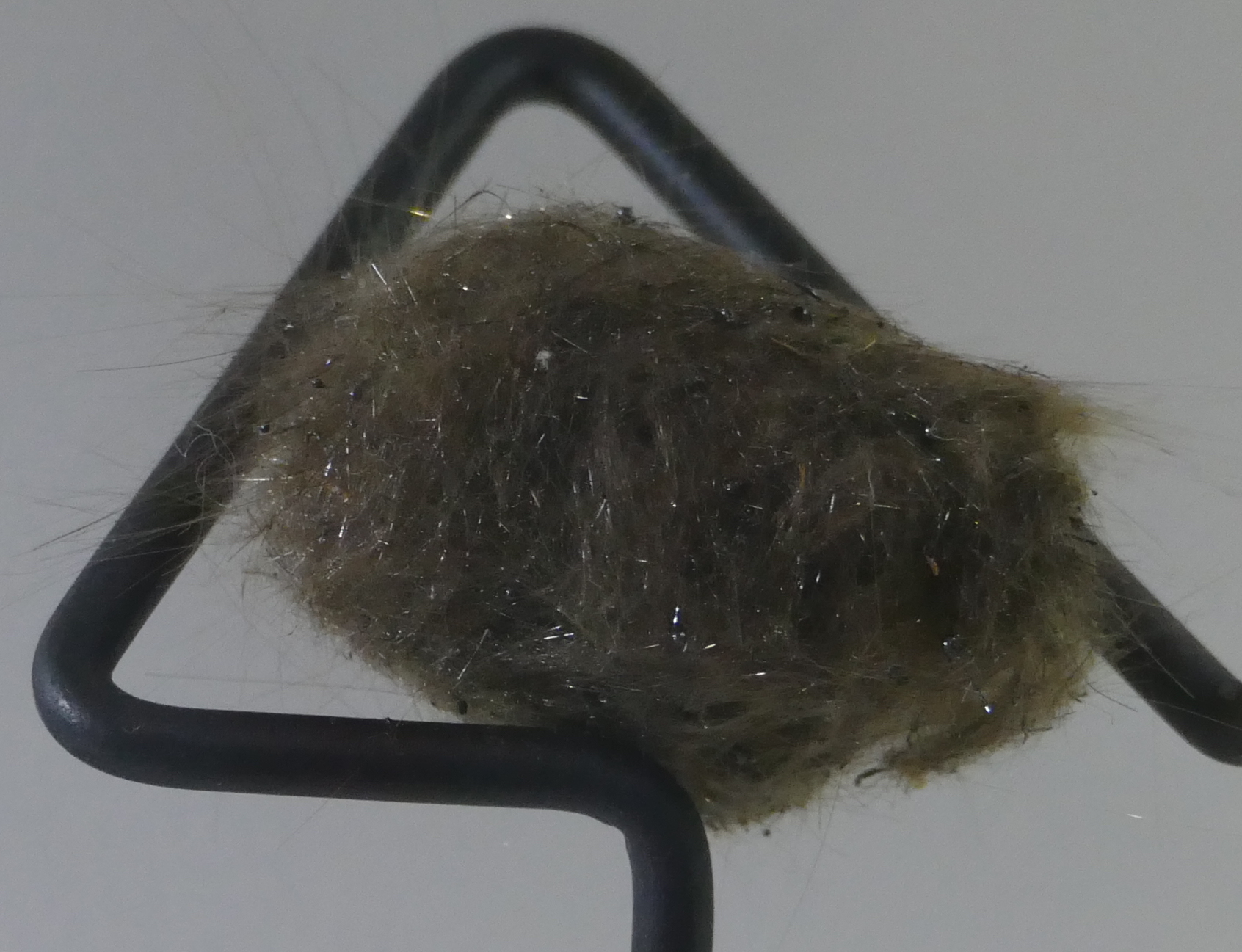
Pele’s hair
An extreme case is that of liquid droplets flying through the air. As they cool they solidify, and form long streamers. This creates the strangest rock of all, with the evocative name of Pele’s hair. You have to feel sorry for her hair dresser! What kind of comb would be needed? This lady is not for brushing! Pele’s hair can be found especially around lava fountains. But beware: the hair strands can be needle-sharp and should be handled only with thick gloves.
The strings come from wind acting on the flying droplets. If there is too little wind, you don’t get strings but tear-shaped droplets (very much like the shape of a drop of water falling from a leaky tap), about a centimetre across. These are called, not entirely surprisingly, Pele’s tears (although with the lady’s reputation, the need for tears seems minimal.)
(ii) Glass
So much for the first of the three effects. The second one is very different: this is when lava is cooled so quickly that it briefly forms a supercooled liquid, i.e. a liquid below its melting temperature. You can create this yourself by putting distilled water in the freezer. It will remain a liquid even though its temperature drops far below freezing. But disturb it ever so slightly, and it freezes over instantly. If you do this with molten rock, and let it suddenly solidify well below its melting temperature, it can create a glass. (The temperature below which this can happen is called the glass transition temperature, which is different for each material.) The trick is to make it solidify all at once, with as few separate crystals as possible.
An easier way to do this is by starting out with a lava which contains a bit of water. Water lowers the melting temperature, and so the lava can be cooler whilst still a liquid. Now evaporate the water (as can happen as the lava becomes exposed to air). Suddenly the melting temperature goes up, and the lava finds itself caught out, being a liquid well below its new melting temperature.
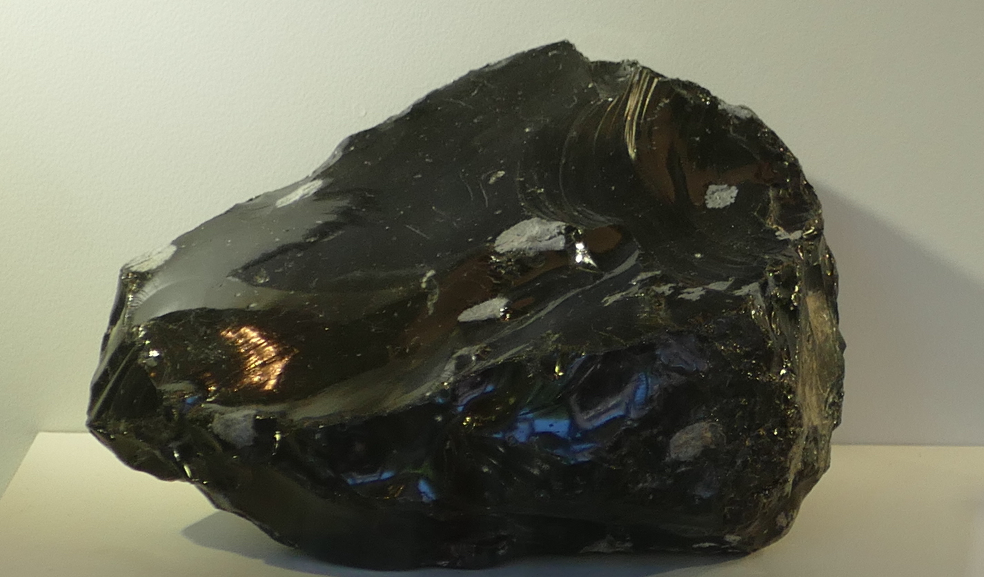
Obsidian
A well-known example of a rock that formed in this way is obsidian, a black rock of volcanic glass. It forms from silicate-rich melts, i.e. from rhyolites. Obsidian was sought-after in the stone age as it can be used for cutting (including the careless owner).
It should be harder to make a glass out of basalt, because it is hotter to begin with and readily forms crystals while cooling. But Hawaiian volcanoes manage it quite easily. Basaltic glass is called tachylite. It can be a thin edge on a crystallized lava flow, but on Hawaii it can form thick layers. And now you will not be surprised to know that Pele’s hair also consists of strands of this glass. Ouch again.
Perhaps the most dangerous of all is when lava meets the ocean. The instant cooling forms small particles of glass, and the rising steam carries them away. The white plumes of Puna, where the lava comes over the sea cliffs, are pretty only from a safe distance. There are several reasons why you shouldn’t breath in the stuff – the tiny glass particles among them.
(iii) Crystals
The third effect is that of crystallization. As lava cools, crystals begin to form. The slower the cooling, the larger the crystals can become. These crystals (or their absence) are easily recognized by eye.
Compare the following wo rocks. Both are obsidian, and thus formed through rapid (instantaneous) cooling. The left one looks ‘normal’: a hard glass, albeit with a greenish tint. The one on the right contains a host of crystals, a feldspar to be precise. What happened? It spend some time cooling slowly, allowing the crystals to form, before it suddenly cooled very fast and let the remainder turn to glass. The texture shows that it cooled in two distinct phases, one slow, one fast.

Two types of obsidian, with and without crystals
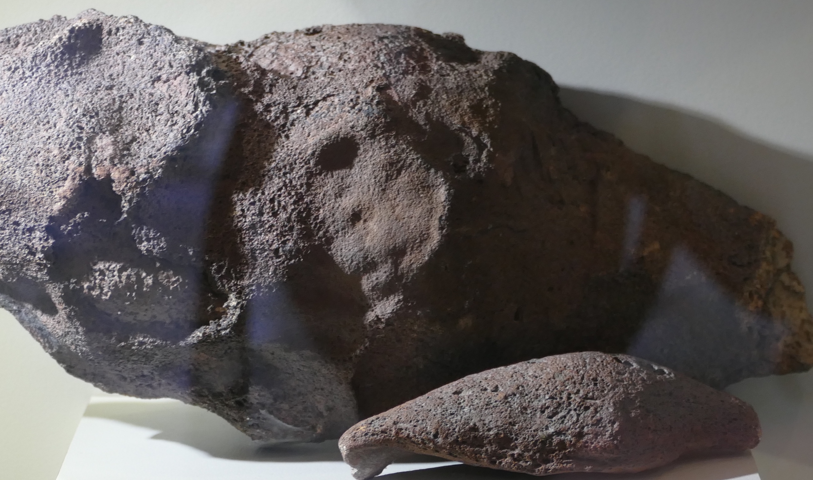
Pitchstone
The next one is pitchstone: also a rhyolitic glass, like obsidian, but containing a larger fraction of minute crystals. It gives the rock a dull appearance. The crystals are very small, and this shows that the initial cooling was fairly fast. Pitchstone contains a bit more water than normal obsidian, and so the rock has a lower melting temperature. The various minerals with the highest melting temperature had time to form small crystals before the remainder turned to glass.
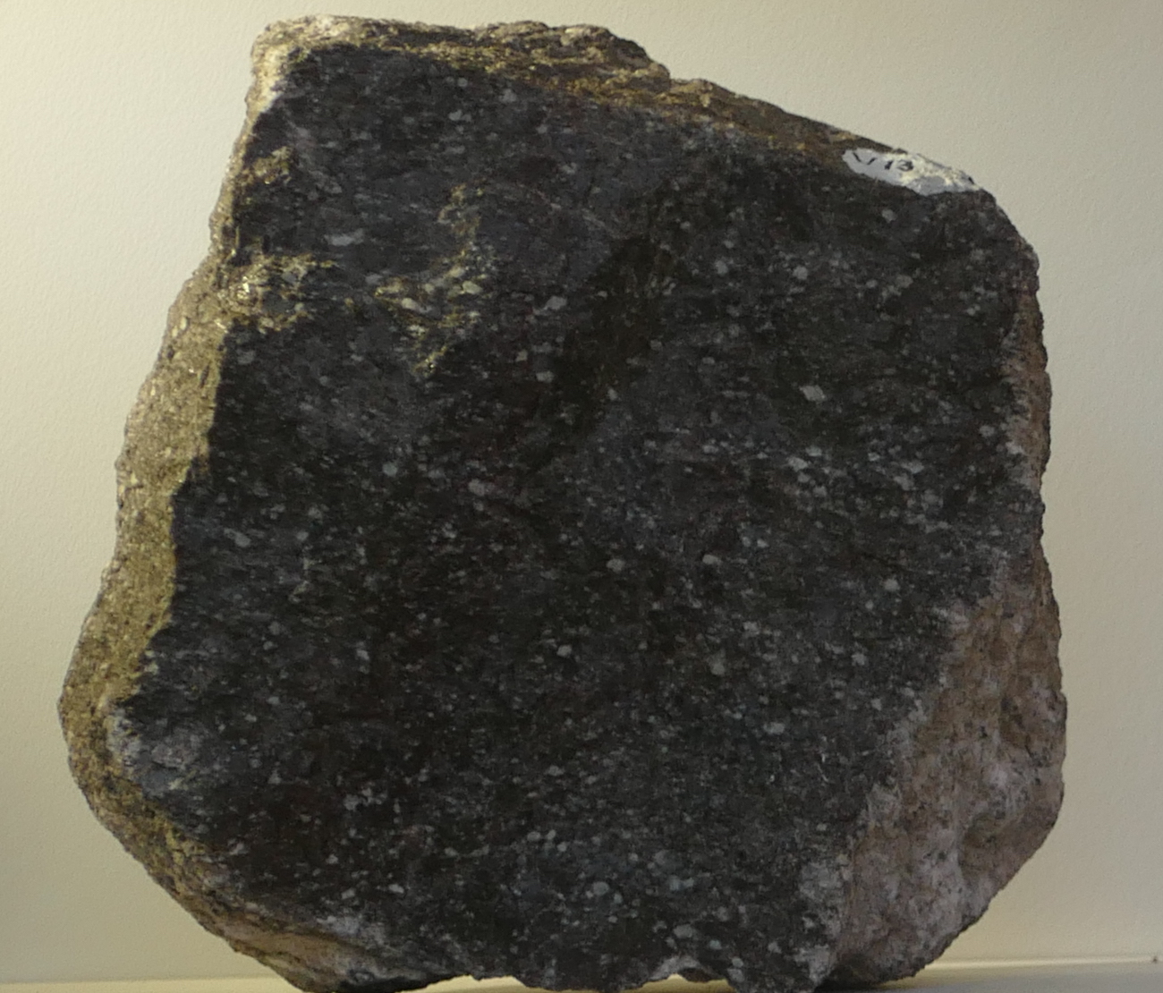
Pegmatite
And finally the other extreme: this is a rock with enormous crystals which must have cooled very slowly. In fact this particular rock, a pegmatite, would have formed in the deep crust, where the cooling was so slow that the single crystal could take centuries to form, before the surrounding magma finally turned to stone.
Fragmentation
Now we know what volcanic rocks look like. But often, volcanic rocks look very different, striated or welded. They also come in a range of sizes, from the island-sized flows of Mauna Loa to the ash of Mount St Helens. What causes that difference?
Fragmentation of the lava comes mainly from explosions. Rock does not easily explode, of course: it lacks suitable chemistry, and lava is nowhere near hot enough to vaporize rock. The explosions come from trapped volatiles. Big explosions come from volatiles in magma which suddenly decide to become a gas, need a thousand time more volume for this, and end up blowing apart complete mountains. But it can also come from trapped vegetation underneath a lava flow, or even in one infamous incident, trapped snow. These kind of explosions produce flying lava bombs – the name is not entirely accurate, as the bombs are ejected by the explosion – they do not explode themselves.
The explosions produce fragments of a variety of sizes. They are distinguished by size.
Particles smaller than 2 mm are called ash.
Up to 6.5 cm it is lapilli.
Above that size it is a lava bomb.
All together it is called tephra.
Lava bombs of two different sizes
What goes up must come down – as true in volcanics as it is in politics. It is important to know that a lava bomb is made of lava – it will happily start a fire if it lands on flammable material; the danger is not just in being hit by a projectile with the size and speed of a cannon ball (although that is not entirely without danger either). They can be as large as 5 meters (although 20 centimeter is a more typical size, luckily), be ejected at a speed of 200 meters per second, and can travel considerable distances through the air: up to 5 kilometers. Lava bombs may also arrive as tachylite. Ouch!
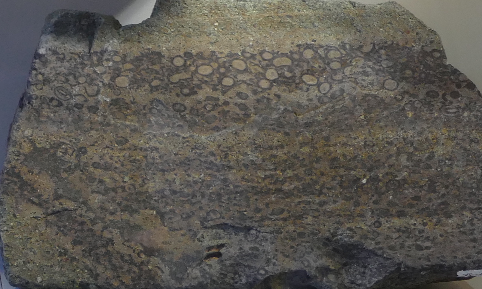
Lapilli tuff
Smaller fragments travel further than large ones because they benefit from the lift from rising hot air of the eruption. These fragments also are much more voluminous, and the ash can cover large areas in a blanket that is centimeters to meters thick. It welds together, either through heat or over time. The welded layer is called tuff.
The name is not fully appropriate because it is the softest rock created by volcanic eruptions. The tuff can embed lapilli fragments and even lava bombs if not too far from the eruption site. Whereas the lava bombs have the composition of the lava, the tuff will often have a composition close to that of the mountain. If lava, it is often rhyolitic (because that explodes well). Tuff is often light coloured, and can be almost white. The best place to find tuff is in local buildings: it is everyone’s favourite building material. Although, be aware, if your local buildings use it, somewhere in the area is a mountain which made it, and which may have its own building demolition program.
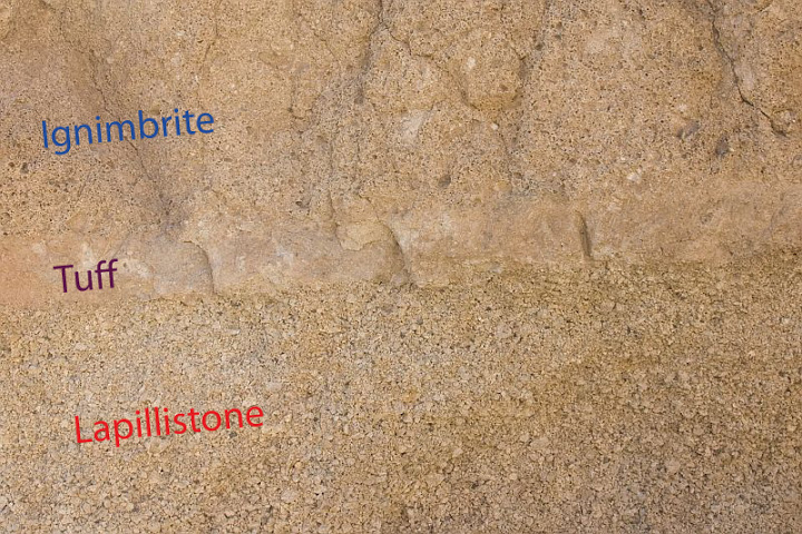
A tuff sandwich. Source: sandatlas.org
The tuff in this image is layered between lapilli (which falls first) and ignimbrite, which is debris from a pyroclastic flow. The tuff can be recognized by its smoother texture.
Gas content
The final piece of the puzzle is the gas content of the erupted lava. If the gas content is high, the lava becomes frothy, and when it solidifies it has lots of holes, like a swiss cheese. There can be so many holes that the rock weighs less than water, and floats: this is called pumice, and it forms especially well after an underwater eruption where the water provides more gas than the lava can cope with. The sea can become covered by rafts of pumice kilometres wide: after Krakatoa, they made local sea travel almost impossible for months.
A floating island of pumice

Scoria. Source: wikpedia (Jonathan Zander)
If the stone has lots of holes but not enough to float it is called scoria or cinder (the two words are interchangeable; ‘cinder’ is older). This is where Cinderella got her name from. (No, I don’t know either. And nowadays she would be called Scorella.) These form especially during volcanic explosions as the gas-rich lava is shot out from the vent.
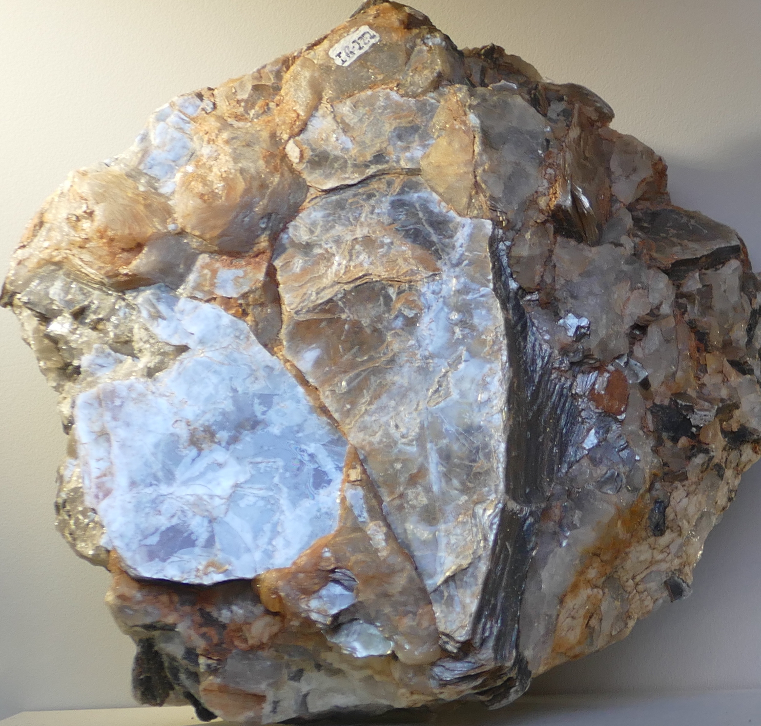
Amygdale
But gas bubbles can also form underground, and leave magma that solidified under ground with holes. Over time, the holes may become filled with water and the water can deposit new minerals, often a calcite. These rocks are called amygdales.
But it can get even better. The rocks can have very large holes inside, and over time, anything can happen in those holes. Open the rock and you may have the surprise of a life time, with wondrous crystals and colours. Here is an example, an oversized amethyst. What causes the different colours? That, my dear Watson, is elementary. But the science of volcanic gems is a different topic – a different post, perhaps.

An oversized amethyst
Albert, May 2018


Well after the shark and chicken leg there is now a full size cow/bull. 🙂
Interesting picture, looks almost like a dragon made of light, for lack of anything that better fits an event like this.
The reactivation of fissure 6 and some of the vents further east is a major deviation to the uprift trend that was happening before, what it means is not evident yet. HVO has also reported that the major source of the big flow was from lava lake collapse of fissure 7, so this flow was essentially like a dam burst flood. It was lucky that no-one died really, though it seems like it was a close call for a few. That video Ikaika took of lava filling an old fissure is incredible.
There is also now a pretty tall lava fountain from fissure 6, you can see the little dots of the glowing pieces of lava above the glowing area, so this fountain is pretty high. (it just changed the picture now…)
Regarding PGV (perhaps this has been posted): “Lava flow from Fissures 7 and 21 crossed into PGV property overnight and has now covered one well that was successfully plugged. That well, along with a second well 100 feet away, are stable and secured, and are being monitored. Also due to preventative measures, neither well is expected to release any hydrogen sulfide.”
http://www.hawaiicounty.gov/active-alerts
I admit that I have no idea how these wells work and what a well even is.
I dont know why they are so scared of H2S in the well water. Yes it is as toxic as cyanide, but it also disperses in air very quickly and more importantly is flammable, which means as soon as the well explodes it will just ignite in the atmosphere as it goes past the lava (the wells are under that much pressure that if it actually bursts then the water will be at temperatures hot enough to ignite it anyway). Poisonous gasses are really only dangerous if they concentrate and it is very hard to concentrate when all gasses are miscible in each other and will escape into the atmosphere. Not to mention the force of the exploding well will send all that H2S high above the ground, so yeah…
The release of all that smoke and acidic steam from the lava is probably a much bigger health hazard than the H2S from one well.
True, but if an identifiable man-made artifact is ejected and causes injury or property damage, now you have someone to sue. For corporations, lawyers are scarier than volcanoes.
Something pretty notable is that this eruption has covered more land in less time than any kilauea eruption since 1840… The flow is probably about 12-13 km2 in area and rapidly increasing, which is quite a bit bigger than both the 1960 flow field and the individual areas of both of the 1955 flow fields. Pretty much every persistent flow from pu’u o’o has ended up being way bigger in the end, but over an equivalent time period none of them have managed anything like this. This is a very big eruption that people in 60 years will look back to in the event of another eruption in the area, just as we look at the 1955 and 1960 eruptions as comparison to this event.
Any idea on the potential volume of lava erupted so far? The fact the summit is still being effected by this eruption suggests that the connection to the summit could be complete and that this is now an open system like at pu’u o’o only with way higher eruption rates. The rate at the moment is probably about 50 times higher than from pu’u o’o before, about 100 m3/s over all vents, with probably 70% of that feeding the big flow to the north.
There is a great difference to previous eruptions at the Lower East Rift zone and that is the activity preceding them. 1840 followed some activity at the summit, 1955 followed a long period of eruptions at Halema uma u and 1960 followed the previous Puna eruption and the Kilauea Iki event. This eruption has comed after a very long and intense period of activity at the Upper and Middle east rift zones beginning in 1961 and extending up to this year and with some acticity at Halema uma u the last years too.
It has also happened following a period of very high magma supply rate from depth. This happened during 1840 too, but not in 1955 or 1960. 1924 probably failed entirely because there wasn’t enough magma coming in to keep the dike open. 1840 was described as being very rapid and that is supported by the size of the flow compared to the eruption duration, but this current eruption is probably a lot bigger than 1955 was at the same time period, and probably at least as fast as 1960 despite the much lower fountains compared to that eruption.
One has to wonder what will happen after this eruption ends. The high eruption rates of the early 19th century (0.15-0.2 km3/year) ended after the big east rift eruption of 1840, but that eruptive period lasted about 50 years before that happened, while this current one (0.2 km3/year) has lasted only 10 years so far, since the overlook crater opened. The middle of the 19th century episode was also when the massive 1823 eruption happened, which drained out the entire caldera of a lava lake probably 100 meters deep and 2 km wide, but that didn’t stop the high eruption rates… My guess is that things still have a while to go before kilauea calms down, probably with another big rift eruption, and a new true caldera collapse probably isn’t going to happen for a couple of centuries at least.
I think I have talked about that idea enough in previous comments though 😉
I dont know almost anything about the 1823 eruption but its supposed to have been just 11000 m³ and a short event so much more smaller than 1840, 1955 or 1960.
Also I dont know of any other big eruptions happening during the early 19th century so why do you think that it was a high eruption rate period?
The eruption cant have been that small, it is absolutely 100% impossible. 11,000 m3 is probably smaller than some of the small flows that happened from vents in pu’u o’o when it was active. The 1823 flow field is much bigger than the 1960 or 1955 flow fields (or the currently active one as it is right now), and is about the same size as the 1840 flow field (20-25 km2). Its volume probably isnt really well known but is likely comparable to the eruptions on puna in historical time (0.05-0.1 km3).
The lava flow is often very thin because it apparently erupted completely passively without fountaining and just flowed down the slope, apparently burying a village and killing several people in the process. The lava must have flowed extremely fast in order to erode the base of cinder cones it flowed past… (yes that actually happened). It actually sounds very similar to the 1977 eruption of nyiragongo, which produced lava that flowed at almost highway speeds at eruption rates that rival those of Icelandic rifting fissures (7000 m3/s is a known figure), but only for a day or so.
Basically the 1823 eruption was a very major event, even if it wasnt the biggest eruption on kilauea it still had a huge impact on the caldera, much more than is happening now even, and yet the activity afterwards in the caldera was extremely intense. The effect it had on the caldera was surprisingly well documented for that time period and the caldera completely drained out all the way, and by the time the 1840 eruption happened it had filled the entire thing to within 100 meters of the rim, and then partly collapsed again before filling up to overflowing in 1921 and then draining in 1924 to form halemaumau.
I would say the 1823 flow field affects an area similar to that of the 1840 eruption but the real surface is smaller because the flow followed channels very often and because of this having a thin branches structure. Also this flow seems to have been extremely thin, as thin as 0.03-0.3 m near the vents, it doesnt reach an average of 1.5 m anywere and at the first 0.8 km from the vent stays thinner than 0.6 m (I didnt even knew flows this thin had been erupted historically).
Taking this into account it does make sense that the volume of the flow was so small compared to 1840. The 1840 is estimated to have been 200000 m³ and so a flow with a similar extent and 20 times thinnier would have a volume of 10000 m³. Maybe 1823 wasnt that thin but it wasnt as extensive as 1840 either.
i dont know how intense was the activity at the summit but I dont think it was that much since there werent any other major flows coming out from the summit area or the southwest rift.
I see what you have been doing wrong, you have forgotten a few 0’s 😉
1840 was 200,000,000 not 200,000. which means you were about 1000 times too small on the volume estimations. That would make your estimate of the volume of the 1823 eruption actually about 10,000,000 m3. That still sounds way too small to me but is a much more impressive number.
The flows are also only thin near the upper vents, the rest is probably about the normal thickness of a lava flow (a few meters). A lot of it also is below sea level in order to have it extend the coast by so much when it entered the ocean.
I think HVO is doing a long term study of the southwest rift zone in order to find out how active it actually is. Eruptions happened there in 1823, 1868, 1919-1920, 1971(x2) and 1974. Ignoring the clustering in the 1970s, they roughly happen at intervals of 50-60 years, 1974 was 44 years ago so another one could be expected some time soonish.
This study should also give proper numbers to how big 1823 was.
Nice article Albert. Love it! Hoping for more! 😀
Quite an uptick in activity under Kilauea.
Source USGS.
Screenshots rom the USGS monitoring site.
Subsidence of the southern part of the caldera floor is about 1.4 m now.
The movement of the gps near the vent was about west the last few points, towards the vent. It may have vanished in the hole by now!
Credits graph USGS.

And can’t stand to share a topic related picture of a piece of pitchstone I recently added to my collection.
It comes from a construction site in the town Zwickau, Sachsen/Germany.
It bears a lithophyse (thunderegg). 😃
Wow. What’s in it?
Ha! Yes, that is a burning question! Likely agate, quarz, maybe fluorite…
I will never know, because it is staying this way for collection sake. 🙂
But to tickle your curiousity here is a fellow egg from the same site, cut and polished, one of the nicer ones I have seen.
Thundereggs form in cooling but still (somewhat) flowing lava. The shape of the egg is a bit oblong, likely caused by this flow.
The orange colored Smaug eye is a xenolith (piece of rock with other characteristics than the surrounding ‘hostrock’. It was taken in by the lava. In this case the xenolith hasn’t any crystals, the hostrock has many.
Lithophysae from Zwickau often are formed around xenolith.
The former cavity of the thunderegg has some greenish debris/glass at the bottom, it has gotten in the hollow through a void. After that a crack was filled and the cavities wall was covered with an orange mineralization. Eventually the cavity was filled with agate.
A new timelapse ade from screenshots of the live streams on youtube by CNN and Honolulu Civil Beat
The CNN images more or less cover the entire period from noon to midnight (Hawaii time) on the 27th of May , though the HCB images are out of sequence.
(The HCB images lost their logo due to an error of mine)
It’s sped up 300 times.
Credit of the images belong to CNN and Honolulu Civil Beat. (I think 😉 )
The obvious difference with the other timelapses is that this one is only about lava rivers. A lot.
https://youtu.be/eiW_mNwmFA4
Also added to the Bardarbunga playlist in my channel
Comes up with a dead link when I click on it?
Deadlink? → “This is CNN…”
Same here. In the Bárdarbunga playlist it is listed as private video.
And that’s why you should always check the link yourself when you are not signed in. Sorry guys, it should be there now as an unlisted video (same link)
Wow there is actually way more activity there than I thought, it reminds me of the pictures of the July 21 2007 fissure between pu’u o’o and kupaianaha. That vent turned out to be very long lived (4.5 years) so maybe this activity will be too…
Its built a series of lava lakes that overflow to make a line of low shields. In 2008 a line of shields formed over a short lava tube and sometimes broke open to release a fast moving lava flow that could go several km in a few hours. These structures are basically the same thing except built over actual vents, so the area downhill might be at risk of sudden fast lava flows that wouldnt be expected from this sort of activity.
The activity further up the rift however… That is a whole different story…
Looks like whoever came up with the idea of a lava flow going towards kapoho could be correct, as the new big flow is very wide on the webcam. It stretches from near the earlier north flow all the way to beyond the edge of the cam probably into lava tree state park. Would be interesting if new tree molds form in the lava in that area (probably not because it is likely a’a lava but you never know).
Most of the lava is still probably going to go north but if the flow spreads out it could get into the drainage that goes to kapoho. It looks like that for the first time in this eruption so far the activity has almost entirely focused to one spot with all the lava, and now that is going into that north flow. The lava livestream shows that lava is still erupting at most of the other fissures, forming a series of lava lakes and small overflowing shields similar to previous pu’u o’o activity, but the amount is really pretty negligible compared to the main vents.
https://www.facebook.com/K.BryanHI/videos/1950704544962624/?fref=mentions
From 2 hours ago by Ken Boyer.
The lava is actually flowing like a river and when you consider how flat that is there must be a massive volume. All I can say is wow.
If I lived in that area I would probably be thinking other things though, but I guess that is the risk of living in hazard zone 1 of the most active volcano on earth. This was inevitable in the grand scheme of things, although admittedly completely unexpected even by HVO up until the intrusion happened.
Looking at the depth of the lava, I dont think my lava castle idea would have saved your house if you lived in leilani though, not against an actual lava flash flood…
Impressive. I estimate a speed of 2 meters per second. The lava river may be 10 meters wide (very hard to guess from the video). Assuming 1 meter deep, that makes a flow rate of 20 cubic meters per second. A typical Puna eruption produces 0.1 km3: this river would do that in about two months. So – nothing unusual!
Judging from the earlier videos of similar lava flows, the edge is probably way higher than 1 meter, likely closer to 2 or 3 and the flows are also probably way wider than is easy to see from that distance (he was something like 500 meters from the flow probably, not sure what street but probably leilani avenue looking south east). The width might still be around 10 meters, but it is probably at least a few meters deep if you compare the USGS car to the lava.
That would make it about 60-100 m3/s?
That sounds pretty reasonable given the massive size of the flow on the webcam.
Sure, but it is good practice to go for conservative estimates. They are more likely to be correct.. You can’t judge the depth of a flow, but it is a fair guess that the surface flows faster than the layers below (a consequence of the viscosity of even runny lava). So any deeper layers contribute less to the total flow. Once the surface cools, the opposite happens and the layers below go faster, but this stuff seemed pretty hot. The biggest uncertainty is the width of the channel: 10 meters was a complete guess. On the other hand, it is probably more than 1 meter and less than 100 meter, so 10 meter is a decent ballpark for the ‘order of magnitude’. The speed I got from comparing to the width of the road and assuming it wasn’t shown speeded up.
The unexpected thing is that the flow is now completely dead… Fissure 8 died a few hours ago and the fissures feeding the ocean entries have reactivation again.
But looking at a live stream from Bruce Omori when the flow was active showed it to be much more than 10 meters, probably about 30 or 40 meters.
I think this flow was probably derived mostly from the stored lava in the pond rather than directly from the vent though. You can see everything else in the area just stop when the big flow breaks out, and to the left of the fountain you could see a big glowing area where the pond was. The speed of the flow was also an indication the flow was fed from a collapse of the lava pond, as none of the other vents produced flows that big but fissure 8 wasn’t actually erupting significantly bigger than previous vents were. The episodic nature of this eruption is probably not a good sign of this activity ending quickly, as all the other episodic rift eruptions (1955, mauna ulu, pu’u o’o) have been very long lasting. I have also read that pu’u kaliu was probably like that too so that could give an indication of what this eruption could be like when it ends.
Heres a great view of the channel, you might be able to update your calculations from it.
Summit tilt latest
Photo of the the lava reaching PGV.
https://www.facebook.com/VolcanesyCienciaHoy/photos/pcb.539205893144049/539197616478210/?type=3&theater
Photo courtesy of VolcanesyCienciaHoy.
Just now… That looks like a more powerful explosion to me, definitely directed rather than a wall collapse with passive ash emission.
Looks like the 16:24 quake started a party with the emissions and 4 quakes over 3 in the area. Looks like it has settled down some now.
big jump in summit tilt
More magma?
What is this? https://www.youtube.com/watch?v=vp_Xwdmrifk
Oh no, not another psuedoscience video!
As I thought, thank you.
and i’m liking the comment of “and where is the Geothermal well that caused the rift 50 years ago…. put the pipe down.” Do the Hawaii islands suffer huge landslides? yes. No one in their right mind is going to go thu a lot of trouble and money to cause it to slip before it’s time. Where is their motive; where is their benefit? Enough goes wrong without planning it…. rifting done, motsfo ((but there is enough paranoia to go around))
Reminds me of email scams – the moment you see them, you go duh… delete… but some are funny in their expression of utter stupidity.
Yeah, that is not even Pseudoscience anymore. Just another visit from the mad tinfoilhatter.
tin foil hats do have their purpose…. they can vastly improve tv reception in remote areas. 😉
Well, the crinkly parts can act as good ion streamer origins. I guess this could facilitate the formation of stepped leaders so that they have a better chance of getting nailed by the main strike from lightning.
I just read an ‘article’ (a.k.a rubbish) in the UK Independent that lava had ‘engulfed’ the well heads at PGV. However, we are told PGV had saved the planet after it had: “deactivated wells which tap into steam and gas deep in the Earth’s core”. (Exact quote).
It’s nice to come back to sanity on these pages. Keep up the good work everyone!
Hawaii News Now seems to be a good source.
http://www.hawaiinewsnow.com
Also the Hawaii Civil Defence site is worth a look.
What on earth were they expecting – the entire contents of the earth’s core (ok, the runny bits) to come shooting out like juice from a lemon?
If it will keep people reading/watching, they will say anything, no matter how idiotic. It’s all about keeping people alarmed or scared. People in fear will pay attention to the latest “update” (even if it was said 6 hours ago). That equates to more viewers/readers, which means more “eyeballs” they can sell to advertisers. It’s their business model.
It’s not about accuracy, it’s about fear.
Pretty much so, I guess….
This was just a matter of time.
“SC TV journalists killed when tree falls on vehicle while covering storms”
3 3.5 quakes at Kilauea in the last few min.. Looking at the seismograph, they might change at least one of these.
Thanks Albert for very much needed info and as usually served in a very entertaining way..
Looks like the lava from fissure 8 has reached Pahoa Pohoiki road as seen in the PG cam. You can see the white structure on the far right of the screen now burning.
DO NOT TRY THIS AT HOME. (Although I’m sure that a significant percentage of you WOULD try it ..)
i watched this earlier in the night and so glad i didn’t wait to see the end… i’d be having kittens and at my age and blood pressure, not good. Glad You caught it though. Best!motsfo
Well, I knew it couldn’t end that badly because I’d read on here that nobody died last night and you can’t upload video from a camera eaten by fire or lava — and if he died it is unlikely the video would be uploaded that quickly. Without that information / knowledge I probably couldn’t have watched it.
My guess is that this is one of the people they were discussing on the radio about being “stranded” on the roof. Things were quite active on broadcastify. I’ve been in the Fire service myself, and it was the first time I actually heard a unit out in the field on a call, dispatched back to their station. Someone had evidently pulled up at the station in their car complaining of an allergic reaction but the crew from that station was busy elsewhere.
Interesting. I was wondering where the information about nobody died and rescues was coming from. There are too many information sources and I’m only aware of a handful of them — already it takes over an hour to try to catch up on what happened while we in the mainland US are asleep.
Geo
How do you know if this website is working? It shows online with listeners but th counter is not moving.
Thanks
Mac
Never mind switched to windows media player and working fine.
Mac
I usually crank the volume up on my phone and listen for hiss. My main issues are loosing connectivity while on local WiFi. When I switch to phone network only or back I get good connectivity.
Right now the big emphasis is on investigating a plastic bucket on a roadway.
I have to admit, I was literally glued to the broadcast until they reported the guy they were rescuing had no medical issues.
If I lived there I would try that. 😉
I mean if your house was in front of that there wouldn’t be anything you could do about it so you might as well stick around.
I dont think my lava castle idea would have worked against that flow, even if the flow basically ended only 10 hours later.
Meh… subtropical storm Alberto seems to have made landfall. My greatest problem is the dogs are timid about going outside in the rain.
I’m glad all is well in the panhandle. I live about 10 miles south of Ellicott City, MD where they had a second 1000-year flood in two years on Sunday. The buildings in the historic district are mostly stone construction and have survived at least four major floods and two massive fires in my life. Amazingly, they keep rebuilding. I think this time they should invest in that porous concrete for the road beds over major drainage canals.
We received a good deal of rain in my neck of the woods and had raging torrents that briefly qualified as navigable water ways running between ours and the neighbors’ yards. Luckily we are near the top of a hill and water drains away from us. Ellicott City is where three or four hills and streams drain into the Patapsco River, so all the surrounding water comes through Main Street during a flash flood. Both Ellicott City and Laurel to the south of us were built up in an age where rivers supplied power and transport infrastructure for mills and are vulnerable to flash floods.
It makes some interesting parallels between Puna and here. Kailua is more dramatic and slow to unfold, while flash floods can change everything in an afternoon, but the geological risks are comparabily predictable. The disaster footage was briefly competitive.
Are we expecting any new fissures to form in hawaii in the coming days?
Dunno, but listening to the radio chatter, they launched a drone to seek out a reported new fissure that the EOC had reported.
Has a fissure formed at that highway yet?
No idea. But the chatter I’m listening to is
https://www.broadcastify.com/listen/feed/28068/web
But most of it is the general sort of traffic you hear… investigating suspicious persons, people being stupid and other assorted Homo Stultus antics. Several days ago there was a report of a guy that fell INTO a tree. (off of a deck)
From a discussion with Albert last night, it seemed that one rescue pointed towards much of Leilani being in peril due to the location of the house that a guy was rescued from. As they retrieved him the house he was in up went up. Best estimate of the location pointed to all of Leilani was downhill from where the magma was at that got the house. This was spotty information at best and was based off the roof color noted in the broadcast.
In general, all of the traffic seemed to carry a much more urgent nature from the way the voices sounded. A heavy emphasis was placed on keeping track of where the rescue personnel and assets were at. {Which is a very smart way to conduct operations, it lessens collateral injury.}
Side Note: Yeah, they are using drones and helos to assist in their operations, but they are maintaining close coordination with air traffic control. Typically their cleared operations area is below 1000 ft AGL. As many as two drones are in use at any one time from what I can hear. Mainly they use them to inventory structure damage and to reconnoiter the area for trapped people.
Hopefully someone there will catalogue issues and events from their drone usage and will develop a guide for drone usage for emergency operations nation wide. They seem to be hitting all the safety of operations points quite well. This would likely be better than the random helo that the Sheriffs department in Escambia County Alabama had up looking for a runaway Goth teen there. (I didn’t even know Alabama had Goth teens.)
Ah, you remind me of the UK Surrey Police helicopter ‘service’. They regularly clatter over my garden to say ‘hi’ to their buddies in Reigate Police HQ, circling the HQ for a few minutes. Other times they hover over the town looking for a stolen kids tricycle or something. I never see any arrest successes from the crew.
I honestly wish they’d go and do something useful.
Then you will like this short story…
Local county sheriff had their helo up looking for illegal “grow operations” in the north part of the county. They found one and called it in, requesting the closest LE asset to make the actual bust. Dispatch had the courthouse annex guard walk across the parking lot and around the wooden fence to make the arrest. The grow operation was literally visible across the parking lot from the front door of the courthouse annex.
Only partially related.
Several months ago, we had a fugitive running around in the wooded areas of the north part of the county. Reportedly, he had a female accomplice. Originally she was reported as a hostage, but trail cam imagery showed her brandishing a weapon and following the fugitive down the trail. I wonder how her lawyer tried to explain that one away.
Near the end of the video, the guy on the roof says where his house is. I think he says he is “at the top” of whichever road (Leilani?) and mentioning the cross street. Says the car / truck is parked outside “the gate” and shows the lava flow tongue that would cut them off from escaping.
In case that helps anyone pinpoint the location …
From the traffic on Broadcastify, evidently the stress levels of the residents is growing more profound. More and more of the incoming calls involve the complainants being quite rude with the call takers.
{…sigh, if only they had listened to the Evac notifications…}
Luckily, most emergency operations personnel don’t follow an old axiom I’ve heard used time and again. “Poor planing on your part does not constitute a crisis on my part”
Yeah, you may be in a world of shit, but you really shouldn’t take it out on the very same people you are calling for help.
well i was in a good connection to listen to all…. The guy they guided out with a drone was on Nohea or close to it and was asleep when they went thu with police sirens blasting… i was listening to a guy at the end of the street. The guy woke up and his driveway was blocked with lava and the police led him out thu the back yards until safe….. the guy on the roof at the top of Pohoiki was not trapped at all. He was watching the advancing lava come slowly in his direction and had planned to stay until the last minute. His exit was well planned. He got great shots all night. i just couldn’t stay up past 2:30am here. He lived at the residence/shop/garage of his boss who gave him instructions on what to remove. They couldn’t find the genny/jenny/generator and concluded someone else removed it earlier. He had lots of company there. i thought it silly to stay that long. He got great shots of the almost/or full moon above the huge billowing orange red clouds. For some strange reason i just tripped into one great coverage after another. Today is toast tho….. Best! from bleeryeyed motsfo.
at I:55 is a good shot of house burning which the guy shot from the roof most of the night. The rest of the vimeo is really nice… Mick Kalber does a good job.
Yeah, I was quite amused at the fate of the “trapped” guy. Since the responding unit had a clear view of his area, they relayed directions to the guy via the dispatcher who was on the phone with him.
so no drone??
Not even the helo he kept asking for.
It’s callous, but I got the distinct impression that he really, really wanted a helicopter ride.
One thing people REALLY should understand, if you call for rescue… How that rescue is performed is at the discretion of who comes to rescue you. Every single time it will be performed in a method to reduce the chance of becoming a casualty while trying to extricate you from your problem.
If Fire and Rescue shows up at your traffic accident and tears the roof off your car, it’s so that they can get to the patients inside. “Flapping a roof” is a practiced skill set for vehicle rescue operations. As is prying a steering column up into the dash. We used to get a junker delivered to us about once a week for the scheduled training exercises.
USGS shows 177 quakes for the past 24 hours for Kilauea summit. There is suspicious concentration to the south-southwest all around the vent.
That’s some hammering the caldera is taking.
After the next period of rains I won’t be surprised to see many fumaroles pop up. Perhaps the caldera will then be renamed Misty.
so on the drone in question…. this news brief talks about it toward the end of the interview. http://www.bigislandvideonews.com/2018/05/28/video-scientists-provide-hawaii-eruption-update/
From the video, “the activity of last night was due to renewed activity at vent #8”
The eruption is now in a different phase, where a fissure opens up, become vigorous, and drop off again over quite short periods of time. They re-active and re-die in a similar fashion. These are pulses of overpressure. I would have expected that the eruption would focus on one particular fissure and stay there but that hasn’t happened.
If this continues, the area around the fissure line will be hit hard (i.e. Leilani) but the lava is less likely to reach much further because each flow doesn’t get enough time. The next phase would be that the eruption becomes intermittent.
At the same time, there is a definite regression of the eruption with the main eruption sites moving uprift. That may well continue
I think the reason is that the pressure in the dyke is getting smaller, either because the flow rate is reducing or because the ‘head’ at Kilauea is getting lower. The fact that the Pu’u’O’o GPS is showing more deflation also suggests there is now less magma coming through the dyke.
The HCB live stream would tend to disagree with that idea quite strongly… The area has reactivated quite significantly over the last day, not at high level but similar to the activity that was happening at pu’u o’o in 2007 which was the start of a very long lived vent that lasted until the 2011 kamoamoa eruption. This is combined with the continued now pretty high fountaining in leilani.
We’ll see. It is too early to say how this will develop. The deflation along the rift from Kilauea suggests it is erupting a higher rate than the magma supply rate in Kilauea. That can’t last, of course. HVO thinks this eruption still has some time to run. But it seems a bit far along the rift for a long-term stable eruption. There must be a distance limit for that, because long-term eruption rates are limited by the magma supply, and at lower rate magma can’t travel as far along the rift (both because of the pressure needed to keep the dike open, and because the magma should avoid solidifying along the way.) My feeling is that this is developing as previous eruptions did and is likely to end the same way. It is becoming quite a significant eruption, that is clear.
But to look at it differently, so far the eruption has drained only a few per cent of the magma chamber of Kilauea.
Mauna Loa has gone deadly quiet during these events.
Helicopter ride over the activity yesterday.
Oh come on… why don’t they just go ahead and play The Ecstacy of Gold for the background music?
It kind of reminds me of the film Blazing Saddles, where the camera turns from the riding cowboys to the bus with an orchestra following. I could picture some guy with a keyboard sitting in the helicopter…
John Davidson was just live from his house were they are filming live from (Civil Beat CNN) and said another lava lake is forming.
Anyone awake / here now and not watching CivilBeat really needs to start watching. If for some reason the camera is looking at one spot when you try, rewind to about 6:30 to see amazing panoramas.
FWIW, there is a river of lava flowing on the side of the fissure row closer to the house (vs toward the ocean.) I guess it would be generally NE.
Its building a shield. This is not a good sign of the eruption ending soon as it means the eruption is stable. There is still rapid and now very high fountaining up to 100 meters in leilani but this activity is significant.
Their house is fine though, it is way up hill of the vents. Anyone downhill should be concerned though as these lava lakes could collapse and send a big flow downhill, probably even faster than the one last night because of the steeper slope. Or the eruption could just completely relocate and this spot starts high fountaining instead…
It is almost like the situation of pu’u o’o and kupaianaha in 1986 except there is both fountaining and lava lakes at the same time…
John just said he keeps feeling EQs. (7:28 Hawaii time.)
There was an M4 earthquake just now south of Kilauea. It is in the rift zone, not the caldera.
It looks like there is a very big lava fountain in the middle of the webcam. It is definitely taller than any other fountain I have seen so far but doesn’t seem to be creating a really massive flow, more just jetting really high. Maybe that is the natural progression of these eruptions, they erupt more lava as they form but as they decline the vents get more narrow so the amount actually erupting from the active ones means it fountains higher.

This fountain is probably 100+ meters tall based on the size of earlier fountains and comparing to this one.
here is some high fountaining lava i think it says 1 hour ago… https://www.facebook.com/isaac.krakauer?hc_ref=ARRYqZ9mc1pkjuXwJctxbrF2cSQoikIXqAvgWnRbDQAs-OA-N_3ox7VGp6mmc5ODxYM
Oh wow that is actually a genuine high fountain. If he was on luana st then he must have either been south of the fountain or he was north of it and actually about a km away from it… I’m assuming he is south of it. I think that is probably the same fountain as in the picture above.
Actually, I just measured it and that fissure is fissure 8. It is about 450 meters from where he is (he is south of the fountain).
If someone could work out the angle he was looking at then you could find how high the fountain is. He was definitely looking up at it though so that already tells that it isn’t small…
Is there a picture available that is visible to non-facebook users?
Ditto…
Same here..
You cant watch it without an account?
I could watch all of EpicLava’s videos on the 61g flow including all the live ones without having an account. I dont know why you cant see this one.
Some you can and some you can’t. And it changes with time. Probably Facebook’s attempt to force you to sign up.
I will not be coerced. If it’s not outside the Forcebook realm, it’s not worth watching.
did a little search and this is the last house on the right before the fountain… https://www.facebook.com/isaac.krakauer?hc_ref=ARRYqZ9mc1pkjuXwJctxbrF2cSQoikIXqAvgWnRbDQAs-OA-N_3ox7VGp6mmc5ODxYM
The entire fissure is starting up again right now…
I guess this is the one from Isaac referred to above
Yes, Rob, that’s it…… A++ to You too!
Yes.
Good to everyone who will not be coerced…. i was such a neophyte…. i joined everything…. and read everything…. it’s how i got real cynical… well if You’ve seen one gigantic lava plume… they pretty much look the same… Best!motsfo
That is what I love about this place. Everyone here is a real character.
I did a quick measurement based on this picture:
 ?_nc_cat=0&oh=075b95cc37a4a37dddfce404e27a7255&oe=5B763911
The big fountain is fissure 8. The much smaller fountain to the left is fissure 21 and between them is fissure 7 which is barely visible. The distance between the two according to the updating google maps is about 600 meters. This picture was taken about the same time as Isaac’s video, within an hour afterwards
That is a big fountain…
https://www.facebook.com/Epiclavatours/photos/a.233824256800845.1073741827.233593430157261/825615147621750/?type=3&theater
This is the correct link.
According to Google Earth Pro the coordinates given for fissures 8 and 7 are 276 metres apart. According to Photoshop the height of the fissure 8 fountain is 34.28% of the distance between fissures 8 and 7, which makes it about 95 metres high at the moment the photo was taken, which appears to be a few seconds after a peak, If the top of the red haze above the fountain is spatter, then the fountain reached heights exceeding 115 metres.
Well the coordinated of the fissures could have been taken from places that arent at the exact locations of the erupting vents. It really should be called vent 8 instead of fissure 8 now. The vent seems to be almost exactly on luana st based on the video, probably within 20 meters to the west. Fissure 21 is a bit further east than hookupu st and slightly north.
I measured that distance to be about 740 meters. That is higher than the actual distance because I free handed the line and it wasn’t perfectly strait but the vents are definitely a lot more than 300 meters apart. That would put the fountain at over 200 meters high. HVO are reporting the fountain to be 200+ feet but I think they are way underestimating, either that or it happened after that update.
The glow is very visible on several of the pu’u o’o cams, so this is still very intense.
Watching the CB live feed and spreading lava while listening to the sound of the frogs in the background, I noticed a passing comment on the frogs being an invasive species. Is not everything on a volcanic island an invasive species? When does something become a native species?
When it finds its place and helps keeps the local ecosystem in a long term balance that isnt detrimental to the system as a whole I think.
Hawaii is one of the places on earth that has been most altered by us, it is almost completely changed from what it was before human arrival, but most of the obvious change within the last 200 years.
Introducing large destructive land mammals like cattle and small carnivores like mongooses definitely didnt help either, and neither did the use of one of the islands (kaho’olawe) as a high risk military training ground from WW2 up until 1993…
Those were definitely deliberate actions that were done with full knowledge of the consequences. Its the same situation as cane toads in Australia (which were brought over from, where else, Hawaii)…
(Cane toads are native to South America but were introduced to Hawaii to eat cane beetles, which they didn’t, and then introduced to Australia to do the same thing, which they didnt, go figure…)
I guess when it enriches rather than reduces the previously settled species. (I.e. if they are edible.) And perhaps they should be called ‘economic migrants’ rather than ‘invaders’?
… so, when the organism switches from a parasitic to a simbiotic lifestyle?
That worked well for intestinal flora.
I think Dragons would be a native species to a volcanic island?
VC Dragon → I’ve only been there a couple of times. We (dragons) have nothing to do with the pissed off Volcano Goddess. It’s her turf, is she wants to re-pave it, it’s her land.
Fish. The invader is the island itself.
IMO, when it can withstand the gases coming from the volcanoes, then it has sufficiently adapted to the local climate. John (owner of the house from which CB is filming) took us around his garden and talked about how the native plants were doing well but the non-native things he’d planted were all dying.
Do you live in Hawaii Leslie? The way you said ‘us’ sounded like you were referring to yourself. If you are there then we now have an active user of this site who lives on location of the biggest volcanic event on earth right now, which is really cool 😉
Or am I getting this all wrong and John actually took the livestreaming cam on a tour of the house for some reason lol.
🙂
No, I don’t live there. Yes, John took us on a livestream tour.
This is the ‘R3’ camera on Pu’u’O’o, Anyone know what it is looking at? Or has it been moved? (It is, after all, Mobile camera 3)
That cam was over looking the 61g vent area and upper flow field. It is still there but now it looks at the glow of the distant puna eruption. Up until about a week ago you could still see glowing skylights on the 61g tube.
That glow is very bright too.
Not the full moon rising?
The moon looks like a small bright dot in the webcam and is nowhere near as bright.
This is the glow of the lava fountains and flows mostly from fissure/vent 8.
Full moon doesn’t rise in the middle of the night. Or set in the east.
Has anyone done a ‘timelapse’ of all the daily maps that the USGS has put out of the flow, so we can see its progress? It’d be fascinating. I mean the maps like this one:
Yes there is one on youtube by hawaii247com.
Thank you! That’s just what I was after.
So far, the lava flow is mainly skirting PGV to the north. The pod with 4 wells to the southwest of the plant, K6, etc., are possibly all covered by the lava flow.
M4.5 under caldera @ 11:56UTC 19.414°N,155.282°W 1.1 km depth
It’s in the wrong place. Did this quake lost its way?
For the sake of history, I want to correct this too early report. The USGS has reassessed this quake as a
M 4.2 Volcanic Eruption
2018-05-29 11:56:11 UTC 19.411°N 155.281°W -1.1 km depth
It has been nudged a bit south, and still, as energetic as 24 hours worth of the typical recent swarms.
A rough sketch of which part of Leilani has been overrun by the lava. I found that wasn’t so clear from the existing maps. The elevation contours are perpendicular to the rift ,with elevation dropping towards the northeast, so the fissures tend to leave areas to the south/west of their location alone.
But there is certainly a risk that fissures to the west, perhaps as far as highway 130, will begin to activate. If the activity moves west (uprift), than much of the western side of Leilani may also come under threat.
Before the rain, you really couldn’t get an idea of the size of the fountain because it was so washed out by the intensity. Who would have thought that this camera would end up being at the best vantage of the action?
The lava flow and fountain now. The rain obscures the glow and you can see that the lava fountain is still just as big as before. This flow is going pretty fast too, its already gone past the one from yesterday. I think basically everything in leilani estates east of moku is gone or going, as well as pohoiki road and possibly lava tree state park. I also think it has finally cut highway 132 and now kapoho is basically isolated, if not then it is very close.
Looks like I wasnt the only person who was watching the webcam at that moment.
I also didnt notice how fast the flow is going, it has gotten to the edge of the cam in only 2 pictures. Must be going at 100s of meters per hour.
It looks like there is still a way out of Kapoho via Government Beach Road, but that will be cut too if the flow reaches the coast near Hawaiian Beaches about 9 km away, as seems likely to happen soon.
Given the rate it is going, and comparing to the flows from before that went south, this flow will probably take about 2-3 days to get to the sea. However the area is way flatter so it should take longer. It will probably take about a week at most though which is still not a really long time.
I’d say the authorities will be issuing a mandatory evacuation order for everyone in that eastern corner of the island within a few hours. Anyone remaining could wind up trapped for an indeterminate period when the flow reaches the sea.
Yeah… This is only 25 minutes later…
New lava flow map is out — this video explains some of it in terms of the homes.
That map/video suddenly disappeared for me and says it is no longer available. The latest map I have is this one.
https://www.google.com/maps/d/u/2/viewer?hl=en&mid=1CvBhH9wEeztBrqYbsGDi4YjU1k1QH5AL&ll=19.47653473676522%2C-154.8981190615761&z=13
He took it down once he realized it was wrong (by going out and exploring the area — see video below.)
This is a great view of the vent:
https://www.youtube.com/watch?v=EaPxxXkNWE8
This guy is great, he possibly breaks the law sometimes to get his footage but I dont think there are many people who could show it better.
He is also sort of nostalgic to me too, as he sounds just like someone else who did lava videos 5-6 years ago which is when I started getting interested in volcanoes a lot, back when I was ‘a wee lad of 13’ lol.
I was just about to post this video. The title is “The maps were wrong this morning. Bill’s house still standing and good! 5:07 AM May 29, 2018”. It was posted to YouTube *after* the lava flow map video above.
Also note that he points out he goes downhill to get closer to the fountain, and this may change the calculations (above) for the height of the fountain.
Highway 132 close to being crossed –> FROM HAWAII COUNTY CIVIL DEFENSE WITHIN THE PAST 3 MINUTES
This is a Civil Defense Message for Tuesday, May 29 at 6:30 in the morning.
Highway 132 is being shut down between Lava Tree State Park to Four Corners, due to a fast moving lava flow approaching the highway. Everyone is advised to avoid the area. Beach Road is the only access into lower Puna. You are advised to make necessary plans and monitor your radio or phone for Civil Defense alerts.
Due to the volcanic activity, the following policy is in effect:
Residents close to the active eruption must remain alert to changes in the flow direction, and are advised to prepare for voluntary evacuation should their areas become threatened.
We are on watch 24-hours a day for your safety.
This is your Hawai‘i County Civil Defense Agency.
Kilauea has been very quiet for the last several hours. Could they have changed the sensitivity on the instruments?
That always happens after a big eruption. Only took much longer this time. After ~1 day the activity picks back up.
That, and there was just a 4.5 right under the crater … that might have taken the starch out of things for a bit.
Thou art released from the cookie dungeon – Admin
POC Tilt has reversed since the latest M4.5.
Is the dyke building up pressure again?
Source USGS.

Lava has apparently blocked the main access road to the PGV site. PGV has not evacuated all personnel (at the time of the news report from Hawaii News Now).
https://twitter.com/MilekaLincoln/status/1001543052689793024
https://twitter.com/HawaiiNewsNow?ref_src=twsrc%5Egoogle%7Ctwcamp%5Eserp%7Ctwgr%5Eauthor
The air quality at PGV must be bad:
Source for image: USGS
I expect the Board of Directors are comfortably ensconced in armchairs with a stiff drink as they watch their plant and employees explode. I do hope the remaining staff stayed voluntarily.
I don’t. I hope they had the wherewithal to know when to say “screw this” and left.
Hope they left and that the Board of Directors had the sense to authorise this. It’s very bad PR to lose your employees, especially if they get fried in a lava flow – illegal in many countries, too.
one road left…
and how many people can use it at the same time.
i always muse……. wonder what the people of Pompeii thought? and when did they think it?
leave,,, leave yesterday.
Best!motsfo
“Urk?”
Pompeii – don’t think they were overly happy: many left; and, many of the remainder were trying to leave.
AD79 was not the first time Vesuvius had a large eruption; it has had larger earlier eruptions.
In a future Pompeii excavation archeologists will find people with smartphones in their hands. Last app started: instagram. Casual photo with awesome pyroclastic flow in the background.
So… be on the look-out for Selfie Sticks rated to 1200°C on Amazon.
— Thanks, Geo
How many people are left in the area to use the road?
Factors those who have not evacuated need to to consider is: how long would it take to reach the road; and, how far do I have to travel along it to reach safety at what could be a very slow speed; what are the likely hazards to that road e.g. proximity of any lava flow, is any lava ponding above it, are there any cracks in that road?
don’t know how long the camera will work…. looks like the forest in front is on fire…..
The cam is on a hill and only trees touched by lava start burning. Everything else is way to wet. I saw some trees inside lava flows that only fell after an hour because they had so much water.
There’s a lava flow straight ahead and below the camera. The one that breached PGV and over-crawled up to 4 of the wells.
2018/05/30 VolcanoYT time lapse of USGS PGcam images. http://www.youtube.com/watch?v=BVJEtErSCIQ
at 00:32 ouch! below at the plant
Ikaika Marzo: “… 6 wells are covered by lava …”
http://www.facebook.com/ikaika.marzo
This looks like the video of the fire the lava set off taken from a drone
http://www.facebook.com/ikaika.marzo/videos/1819685314750663/
I’ve been glued to the livestream, watching the lava river diverge and circle ’round things, all headed basically NE. Then the larger branch of the lava river found a way down to the NW. It looked like a waterfall, but, unfortunately, the guys didn’t zoom out a bit or pan the camera to see it.
The whole action of the lava river amazes me. I am pretty sure that I see three levels with the largest and fastest flowing (going SE) on the top of the ridge, the main part of the one flowing NE on the middle layer and a secondary branch of that NE one on the lowest level. Is that correct / does it seem right?
I’m kinda sad that they moved the camera to point at a “blurble” cone (my words) so I can’t watch how the lava flows when it reaches barriers.