
Built on lava rock
What’s in a name. Would lava by any other name smell as sweet? Perhaps that is not the right question: lava is many things, but sweet-smelling it is not. It smells like a rose bush that was doused in some evil sulphurous pesticide and then put on fire. This rose also constantly explodes with a roar well above the legal maximum. No, Shakespeare’s rose is definitely the wrong analogy. The course of true lava never did run smooth.
But in geology, names are everything. The number of different minerals is staggering, and each has a different name which normally reflects its point of discovery rather than implying anything about the composition. Olivine has nothing to do with olives and perovskite is not a rock band. Do you know your cryolite from your kryptonite? How is your appetite for apatite? Studying geology must be like learning Inuit.
Volcanic rocks share this nomenclaturic nightmare. What on earth is rhyolite? What happened to komatiite? And what stuff is tuff? Even google can get confused: ask for amygdale, and it gives the right definition but images of something completely different. At least it knows not to show images of amygdala (which might require that you confirm your age). But for all of you who were confused but afraid to ask, here is help. This post gives all you need to know to understand the variety of rocks from lava, or at least help you speak like you do. Welcome to the club. We all bluffed our way into geological volcanology.
Lava is molten rock. At the end, it solidifies back into rock. So you should get back what you started with, right? Wrong. Just imagine a block of ice. Melt it, vaporize it, and let it condense and freeze, you may get snow. Both are solid water, but that is all they have in common. So too with rock, although with much more variety.
So let’s have a look at why not all lava is the same. For most of the images, if you click on them you will get full resolution. All the poor ones are from my own collection.
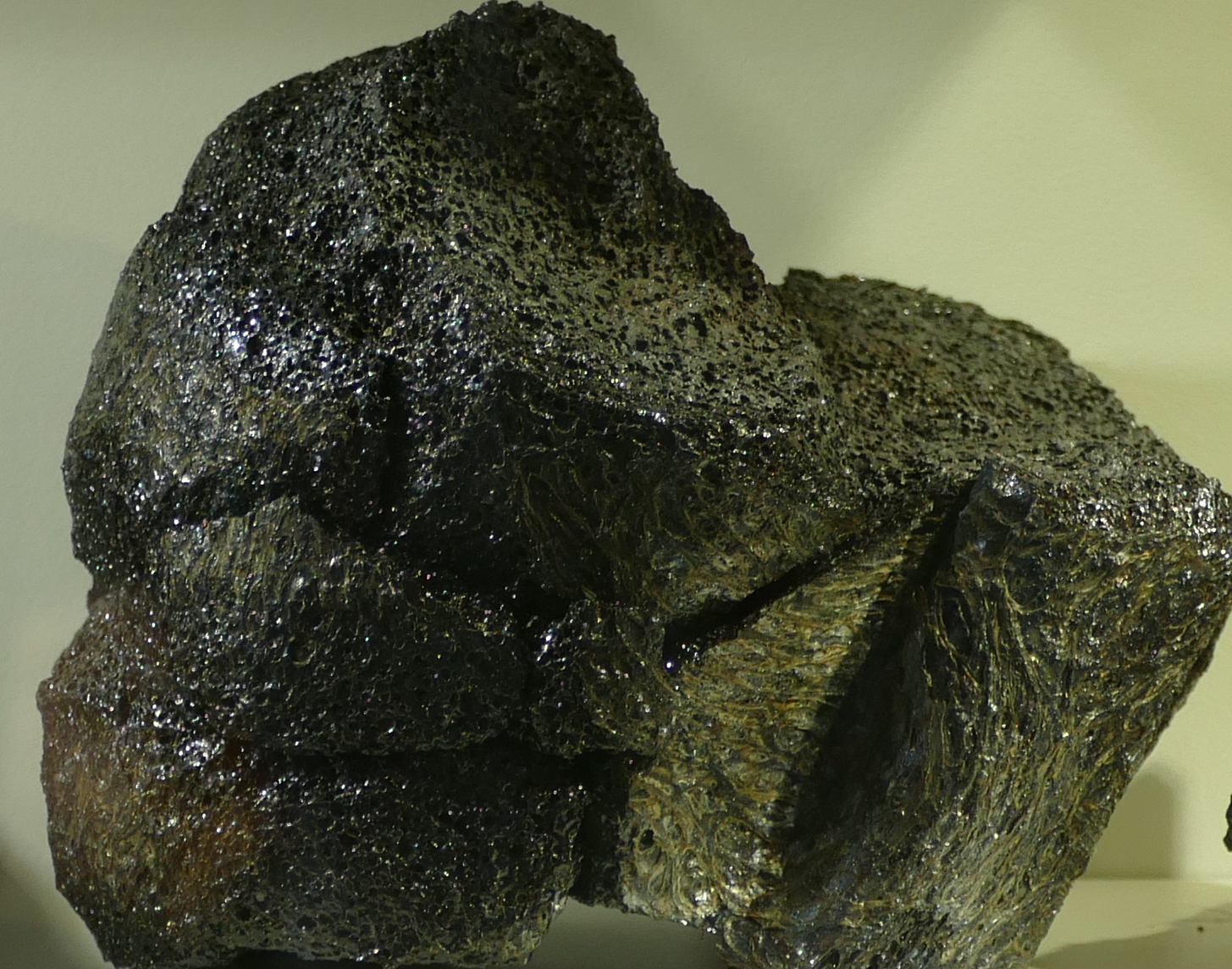
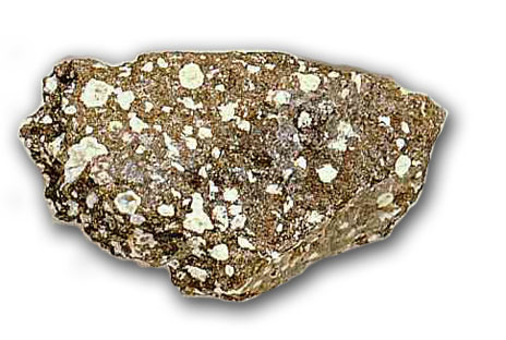
Basalt

Basalt. Photo by the author
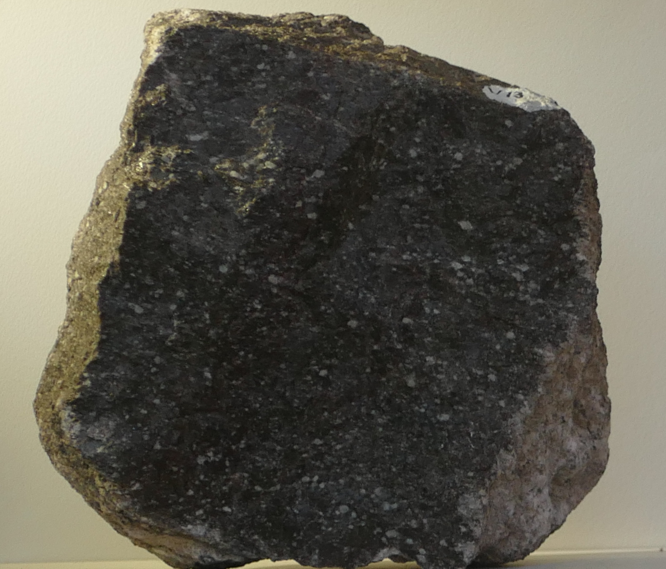
The type specimen of volcanic rock is basalt. It is effectively mantle material, which was melted at the bottom of the crust, ejected from a convenient hole (also called a ‘volcano’), flowed downhill for a bit and solidified there. You are looking at displaced mantle material. Most of the ocean floor consists of this stuff. It is heavy because the mantle is made of denser material than the continental crust (if it weren’t, the crust would sink down like an overweight iceberg and continental existence would be short-lived). In practice, the density of basalt is close to 3000 kg per cubic meter. The continental crust is typically around 2700 kg per cubic meter.
Basalt is the ultimate volcanic rock. Why doesn’t every old lava flow look like this? There are a number of reasons why not all lavas are the same.
1. Temperature and viscosity
The first effect is that of temperature and viscosity. I know, that is two, but they are closely related. Lava can be compared to honey. Warm honey flows easily, but put it in the fridge for a few minutes and it becomes much less keen to spread out, even though it is still a liquid. Honey is actually quite a complex substance, even though it is mainly just sugar dissolved in water. The melting temperature is around 45 C (depending on the sugar concentration): above that temperature, it does indeed behave like sugar water. Below that temperature, it should freeze but it doesn’t, at least not until the temperature goes down to about 5 C. In between, it is a super-saturated liquid, where there is more sugar dissolved in the water than fits. The excess sugar forms crystals and this turns the honey into a mush. As it cools, more and more crystals form and the honey becomes stickier and stickier. Finally, it freezes. (Strictly speaking it doesn’t fully freeze until it reaches -50 C, but below 5 C it is so sticky you hardly notice the difference.) Now turn the temperature back up – and nothing happens until you reach the melting temperature. Funny honey. (When we call a loved one ‘honey’ one does wonder which characteristic of honey is intended. This expression is definitely open to interpretation.)
The stickiness is also called ‘viscosity’. Higher viscosity means stickier, i.e. more reluctant to move.
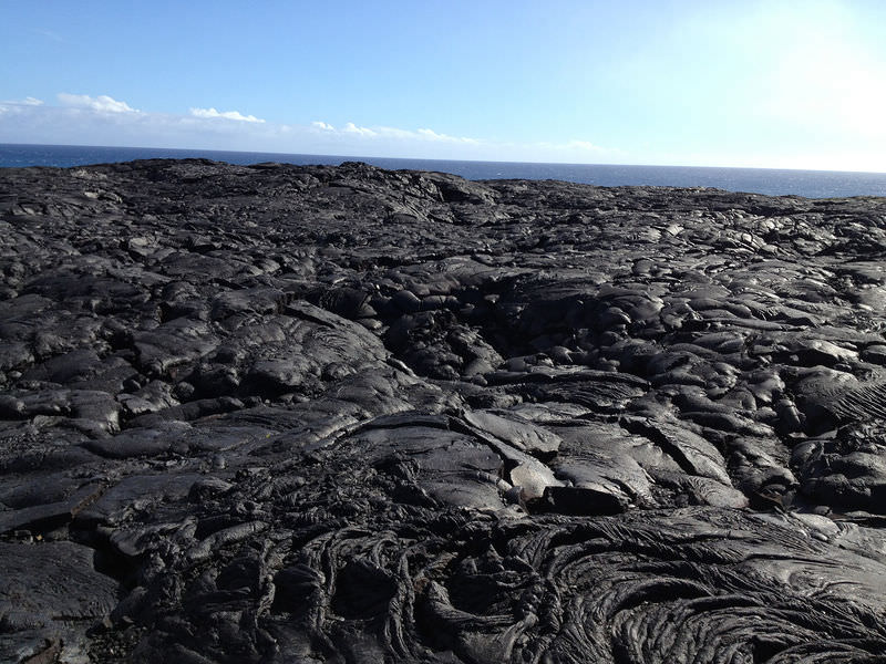
So in what way is lava like honey? Should I call my loved one ‘lava’ or would that get my fingers burned? Well, lava is also a mix of substances, and these have different melting temperatures. As lava cools, some substance may come out of the liquid and crystallize. As more and more crystals form, the lava becomes less runny and more sticky. And this gives rise to the two Hawaiian words used to describe lava flows: Pahoehoe and A’a.
Pahoehoe
A’a.
Pahoehoe is the thinner, runnier lava that happily covers large distances and creates smooth lava flow which afterwards you can walk on. It is the hot honey.
A’a is the sticky lava that refuses to go anywhere fast. It forms very uneven surfaces and is a nightmare to walk on (even after it has cooled enough). Its surface will shred your shoes – this is the one place on earth where high heels may give an advantage. A’a is the honey that has been kept too cool and really would have needed a few seconds in the microwave.
In Puna, the early eruption brought up lava that had been in storage for decades – perhaps centuries. Even though it had stayed warm (a kilometre of rock insulates pretty well), it did not stay hot. This became the sticky stuff, with high viscosity; this explains why the initial eruptions did not produce much in terms of lava flows. It built walls – not roads. Later, the new lava arrived and this was much hotter. The hot, new, all-running and dancing low-viscosity lava ran like runny honey and in no time covered huge swathes of country side.
Even though both are basalt, the two behaved very differently. Poor Puna.
2. Composition
Let me divert for a minute. Lava contains a mix of elements. The main ones are iron, magnesium, silicon, and some other things such as aluminium (called aluminum in Trump land, a spelling that was in use in the UK very briefly but was introduced to the US through the Webster dictionary of 1812.) Each of these forms minerals (mainly oxides), and each mineral has a different melting point. Hot magma contains all these elements and their minerals, although not always in the same ratios. But keep magma for a while in a storage facility (also called a magma chamber) and it begins to cool – very slowly. The first minerals to hit their melting points are iron and magnesium oxides: they form crystals and drop out of the solution. Beforehand, the magma was called mafic (for magnesium (never to be called magnesum) and iron). Now that iron and magnesium are becoming depleted, it is called andesite – you may remember this word from Puna’s infamous fissure number 17.
Store the magma for even longer, and you are left with mainly silicates, mixed with a few other elements (aluminium, calcium, sodium). This is called felsic lava (the word ‘silicic’ is also used). Rhyolite and dacite are of this form. Dacite has made an appearance in the recent Puna stories, albeit only found in deep (geothermal) drilling and not on the surface.
You can expect that this will form a sequence in temperature: mafic lavas are hotter and thus less viscous, andesite is cooler and stickier, and felsic lavas are positively cold (as lavas go) and nearly immovable. And for the most part, you would be right. Mafic flows – felsic stalls.

Rhyolite

Andesite
There are a few exceptions: sometimes magmas form by melting rocks that themselves already lack certain elements. For instance, imagine a rhyolitic magma chamber solidifying into rock. Long after, heat finds its way to the rock and melts it: the new magma will have the composition of rhyolite, but it could well be much hotter than usual, and therefore far less viscous. You can now get a rhyolitic pahoehoe, and this is for instance found along the Snake River in Trump land.
(Hint: if you want to impress your friends, using the term rhyolitic pahoehoe in Puna will do wonders. But avoid saying the andesitic a’a of Haleakala which could leave the impression that you had a drink too many.)
Iron makes the world look black. That is true in lavas as well: mafic basalt is dark to black, while the andesite is greyer and the rhyolite is a bright lava. Of course, add oxygen and over time iron turns red, like the soils of Oklahoma.
I should point out here that the world of lava is simpler than it used to be. A few billion years ago, the mantle was hotter than it is now and therefore lava was considerably hotter as well. This gave a type of lava that is ultra-mafic, an extremely magnesium-rich, which is called komatiite. They don’t make it anymore.
3. Rate of cooling
So temperature is important. But how quickly the temperature goes down is also relevant. Lava rocks that solidify fast look very different from ones that cool only slowly. The rate of cooling has three different effects.
(i) Shape
The first of these makes sense: if the cooling is fast, the flow patterns become fixed in the material. The ultimate example is pillow lava: these are erupted under water, and in consequence cool very rapidly (in the battle between the mid-oceanic ridges and the ocean, the lava has yet to win. Luckily loosing builds character and pillow lavas do have that. Although one could argue that winning builds more character.)
Pillow lavas
Petrified lava ripples
On land, cooling is slower. Thin flows on the surface cool faster than thick ones. In the picture, the difference between the thin flow in the foreground and the thicker ones in the background is notable! The former solidified fast enough that the flow patterns froze in.
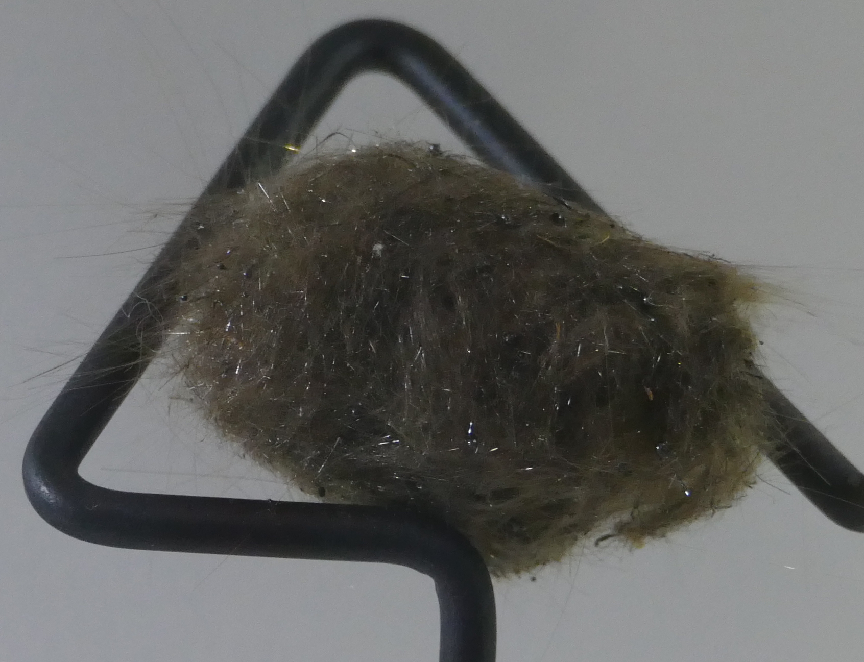
Pele’s hair
An extreme case is that of liquid droplets flying through the air. As they cool they solidify, and form long streamers. This creates the strangest rock of all, with the evocative name of Pele’s hair. You have to feel sorry for her hair dresser! What kind of comb would be needed? This lady is not for brushing! Pele’s hair can be found especially around lava fountains. But beware: the hair strands can be needle-sharp and should be handled only with thick gloves.
The strings come from wind acting on the flying droplets. If there is too little wind, you don’t get strings but tear-shaped droplets (very much like the shape of a drop of water falling from a leaky tap), about a centimetre across. These are called, not entirely surprisingly, Pele’s tears (although with the lady’s reputation, the need for tears seems minimal.)
(ii) Glass
So much for the first of the three effects. The second one is very different: this is when lava is cooled so quickly that it briefly forms a supercooled liquid, i.e. a liquid below its melting temperature. You can create this yourself by putting distilled water in the freezer. It will remain a liquid even though its temperature drops far below freezing. But disturb it ever so slightly, and it freezes over instantly. If you do this with molten rock, and let it suddenly solidify well below its melting temperature, it can create a glass. (The temperature below which this can happen is called the glass transition temperature, which is different for each material.) The trick is to make it solidify all at once, with as few separate crystals as possible.
An easier way to do this is by starting out with a lava which contains a bit of water. Water lowers the melting temperature, and so the lava can be cooler whilst still a liquid. Now evaporate the water (as can happen as the lava becomes exposed to air). Suddenly the melting temperature goes up, and the lava finds itself caught out, being a liquid well below its new melting temperature.
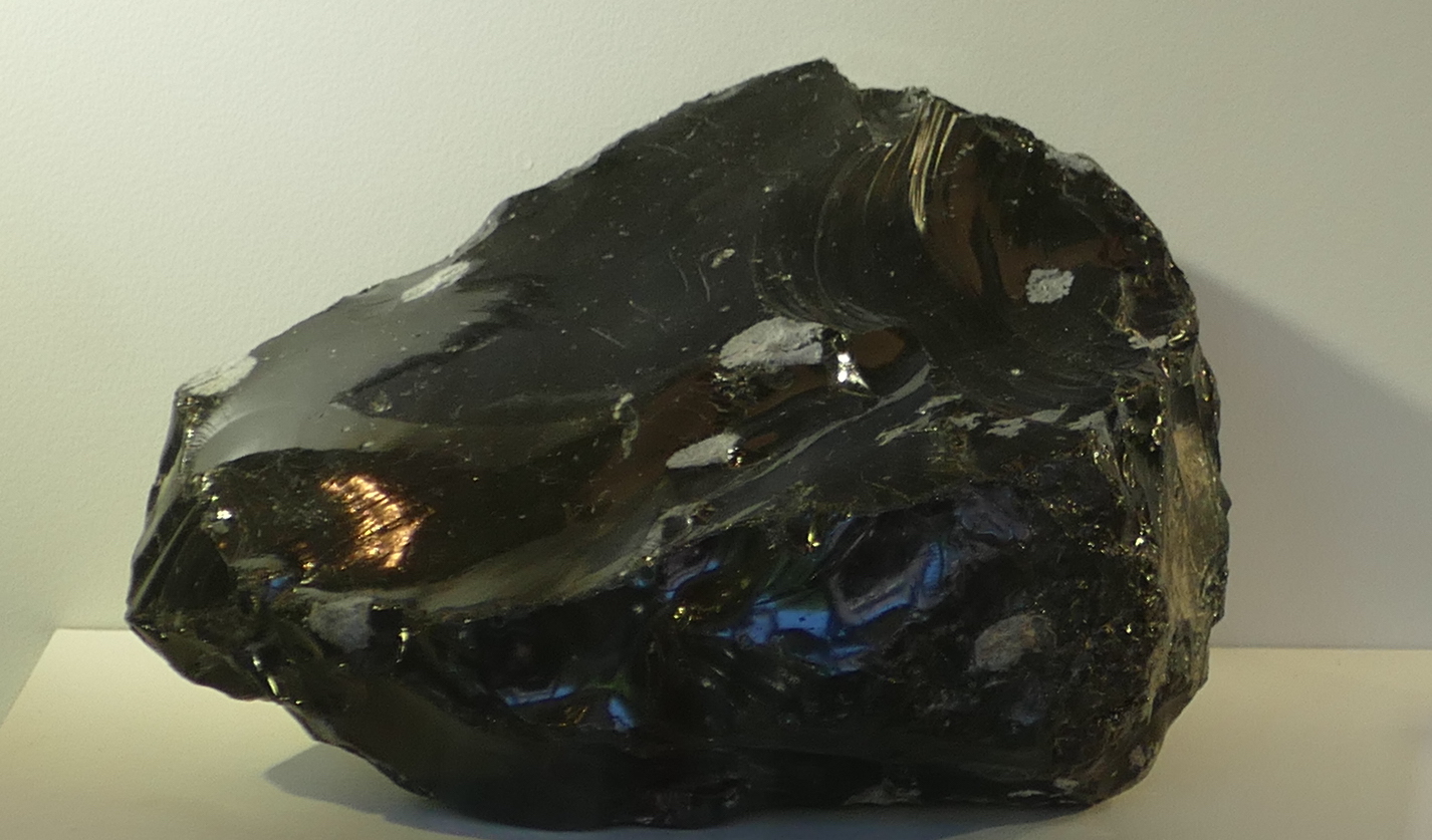
Obsidian
A well-known example of a rock that formed in this way is obsidian, a black rock of volcanic glass. It forms from silicate-rich melts, i.e. from rhyolites. Obsidian was sought-after in the stone age as it can be used for cutting (including the careless owner).
It should be harder to make a glass out of basalt, because it is hotter to begin with and readily forms crystals while cooling. But Hawaiian volcanoes manage it quite easily. Basaltic glass is called tachylite. It can be a thin edge on a crystallized lava flow, but on Hawaii it can form thick layers. And now you will not be surprised to know that Pele’s hair also consists of strands of this glass. Ouch again.
Perhaps the most dangerous of all is when lava meets the ocean. The instant cooling forms small particles of glass, and the rising steam carries them away. The white plumes of Puna, where the lava comes over the sea cliffs, are pretty only from a safe distance. There are several reasons why you shouldn’t breath in the stuff – the tiny glass particles among them.
(iii) Crystals
The third effect is that of crystallization. As lava cools, crystals begin to form. The slower the cooling, the larger the crystals can become. These crystals (or their absence) are easily recognized by eye.
Compare the following wo rocks. Both are obsidian, and thus formed through rapid (instantaneous) cooling. The left one looks ‘normal’: a hard glass, albeit with a greenish tint. The one on the right contains a host of crystals, a feldspar to be precise. What happened? It spend some time cooling slowly, allowing the crystals to form, before it suddenly cooled very fast and let the remainder turn to glass. The texture shows that it cooled in two distinct phases, one slow, one fast.

Two types of obsidian, with and without crystals
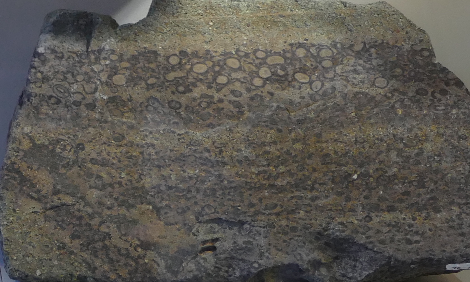
Pitchstone
The next one is pitchstone: also a rhyolitic glass, like obsidian, but containing a larger fraction of minute crystals. It gives the rock a dull appearance. The crystals are very small, and this shows that the initial cooling was fairly fast. Pitchstone contains a bit more water than normal obsidian, and so the rock has a lower melting temperature. The various minerals with the highest melting temperature had time to form small crystals before the remainder turned to glass.
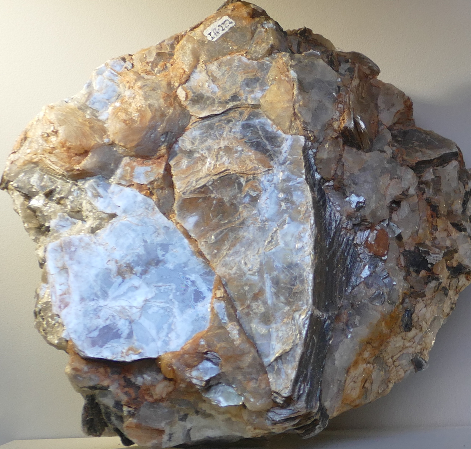
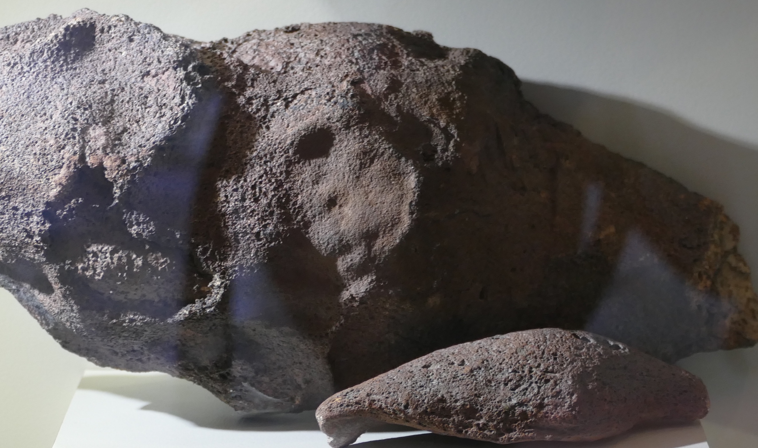
Pegmatite
And finally the other extreme: this is a rock with enormous crystals which must have cooled very slowly. In fact this particular rock, a pegmatite, would have formed in the deep crust, where the cooling was so slow that the single crystal could take centuries to form, before the surrounding magma finally turned to stone.
Fragmentation
Now we know what volcanic rocks look like. But often, volcanic rocks look very different, striated or welded. They also come in a range of sizes, from the island-sized flows of Mauna Loa to the ash of Mount St Helens. What causes that difference?
Fragmentation of the lava comes mainly from explosions. Rock does not easily explode, of course: it lacks suitable chemistry, and lava is nowhere near hot enough to vaporize rock. The explosions come from trapped volatiles. Big explosions come from volatiles in magma which suddenly decide to become a gas, need a thousand time more volume for this, and end up blowing apart complete mountains. But it can also come from trapped vegetation underneath a lava flow, or even in one infamous incident, trapped snow. These kind of explosions produce flying lava bombs – the name is not entirely accurate, as the bombs are ejected by the explosion – they do not explode themselves.
The explosions produce fragments of a variety of sizes. They are distinguished by size.
Particles smaller than 2 mm are called ash.
Up to 6.5 cm it is lapilli.
Above that size it is a lava bomb.
All together it is called tephra.
Lava bombs of two different sizes
What goes up must come down – as true in volcanics as it is in politics. It is important to know that a lava bomb is made of lava – it will happily start a fire if it lands on flammable material; the danger is not just in being hit by a projectile with the size and speed of a cannon ball (although that is not entirely without danger either). They can be as large as 5 meters (although 20 centimeter is a more typical size, luckily), be ejected at a speed of 200 meters per second, and can travel considerable distances through the air: up to 5 kilometers. Lava bombs may also arrive as tachylite. Ouch!
Lapilli tuff
Smaller fragments travel further than large ones because they benefit from the lift from rising hot air of the eruption. These fragments also are much more voluminous, and the ash can cover large areas in a blanket that is centimeters to meters thick. It welds together, either through heat or over time. The welded layer is called tuff.
The name is not fully appropriate because it is the softest rock created by volcanic eruptions. The tuff can embed lapilli fragments and even lava bombs if not too far from the eruption site. Whereas the lava bombs have the composition of the lava, the tuff will often have a composition close to that of the mountain. If lava, it is often rhyolitic (because that explodes well). Tuff is often light coloured, and can be almost white. The best place to find tuff is in local buildings: it is everyone’s favourite building material. Although, be aware, if your local buildings use it, somewhere in the area is a mountain which made it, and which may have its own building demolition program.
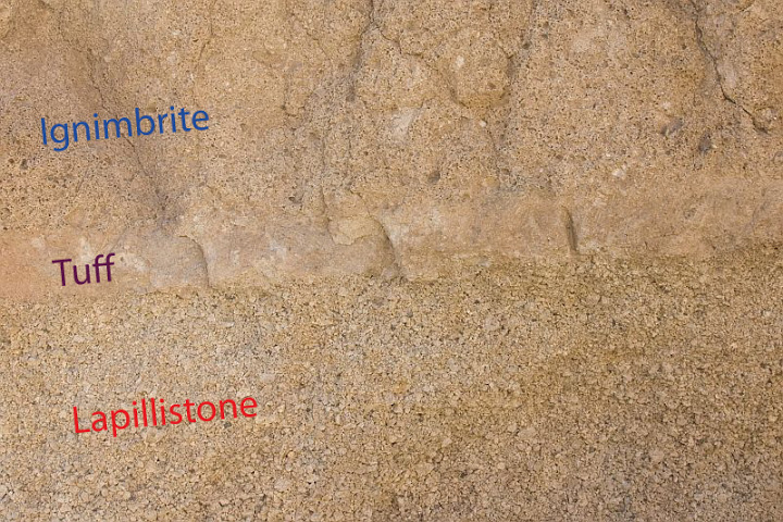
A tuff sandwich. Source: sandatlas.org
The tuff in this image is layered between lapilli (which falls first) and ignimbrite, which is debris from a pyroclastic flow. The tuff can be recognized by its smoother texture.
Gas content
The final piece of the puzzle is the gas content of the erupted lava. If the gas content is high, the lava becomes frothy, and when it solidifies it has lots of holes, like a swiss cheese. There can be so many holes that the rock weighs less than water, and floats: this is called pumice, and it forms especially well after an underwater eruption where the water provides more gas than the lava can cope with. The sea can become covered by rafts of pumice kilometres wide: after Krakatoa, they made local sea travel almost impossible for months.
A floating island of pumice

Scoria. Source: wikpedia (Jonathan Zander)
If the stone has lots of holes but not enough to float it is called scoria or cinder (the two words are interchangeable; ‘cinder’ is older). This is where Cinderella got her name from. (No, I don’t know either. And nowadays she would be called Scorella.) These form especially during volcanic explosions as the gas-rich lava is shot out from the vent.
Amygdale
But gas bubbles can also form underground, and leave magma that solidified under ground with holes. Over time, the holes may become filled with water and the water can deposit new minerals, often a calcite. These rocks are called amygdales.
But it can get even better. The rocks can have very large holes inside, and over time, anything can happen in those holes. Open the rock and you may have the surprise of a life time, with wondrous crystals and colours. Here is an example, an oversized amethyst. What causes the different colours? That, my dear Watson, is elementary. But the science of volcanic gems is a different topic – a different post, perhaps.

An oversized amethyst
Albert, May 2018


Hi All
Two timelapses this time
One made from screenshots at a speed of 240-270 times
Mostly from the cnn feed
https://youtu.be/1L-MtaxsqVU
However if that went to fast for you:
The second one is from recorded video of the Honolulu Civil Beat stream. They usually move the camera too much for a timelapse at the higher speed, so this is at speeds between only 2 to 64 times.
Most is at 8 or below. It really moves that fast. It’s almost 8 minutes and some similar scenes as the first one but from a different angle (last part should not be missed)
https://youtu.be/_mYRG4HZd9g
Or at the end of the Bardarbunga playlist
It really puts this all into perspective when you realize this is the small vent…
There is something fascinating about watching spatter cones form in timelapse… Its sort of a shame that the eruption didn’t centralize in this area and start building a big cinder cone like what is probably happening at fissure 8 right now. I guess there is still the fissure 17 cone, otherwise known as mt rusty… 😉
I really dont see why you cant fly drones around the eruption at all, you could argue that it would disturb residents but I think most if not all residents would like to be able to see the eruption from the air as frequently as possible (more than once a day), not to mention that residents shouldn’t try to actually stay at their house if there is a mandatory evacuation of their area… If you let everyone know you are flying a drone then its technically someone elses fault if they hit it.
If you set a limit to how high drones can fly (200 meters) and how low helicopters and planes can fly (300 meters) then there wont be any danger of a drone hitting the larger aircraft. Also helicopters can survive getting hit by large birds just fine and drones are smaller than that usually.
Emergency Operations are flying their own drones (at least two) and they stay coordinated with FAA controlled traffic and the Helo that is on standby if needed to effect a rescue.
It all boils down to safety.
Personally, if I were there and wound up trapped by a lava flow, I would be extremely pissed off if my rescue was delayed or aborted because some self important idiot got his drone in the way of the rescue helo.
“If you let everyone know you are flying a drone then its technically someone elses fault if they hit it.”
In any rescue, time is a valuable commodity. Mucking up the process with additional UN-NEEDED DELAY detracts from the available time to conduct a rescue. Yeah, I can just see that; “Oh, we’re sorry your family was immolated, but we couldn’t get in touch with the drone operator who was hovering his craft shooting video of your family burning alive for his Facebook page…”
I have spoken with our local Life Flight pilots and one of the greatest problems they worry about, is some dipshit Ultra-light pilot popping up above the tree-line in front of them as they are bopping along at several hundred feet per-second.
At least ultra-lights themselves weed out the stupidest of the stupid due to mishaps. Drone operators don’t typically die off due to their stupidity, so the idiocy remains ingrained in the population.
The story found here about the rescue mission 27/5, where a guy needed to be guided to safety by a drone, underlines your point about drones.
https://volcanoes.usgs.gov/volcanoes/kilauea/multimedia_chronology.html
Scary video. I could imagine the stress of disorientation in that situation..
Uh, No, drones that are illegally operated should be shot down on sight.
!2ga. Mag. #4 shot.
200ft is the standard drop altitude for airtanker retardant drops.
NO ONE should do this in an emergency situation fire flood, volcano.
Yes a drone can bring a aircraft down, intake, tail rooter and my own personal fave, the windshield. A drone into the cockpit can wreak havoc .
Lurk’s bit about the ultralight is true. and happened to me on a fire.
As we were making a drop. Got the Ultra light driver’s attention..
#4 shot is a good choice. A reasonably spread pattern with each pellet able to do massive damage to the drone and bring it down.
Are drones useful? Definitely YES. And the Emergency Operations group in the Puna area seem to have found the correct niche and balance to safely use them in protecting people.
Using a drone so I can get a cheap thrill of looking at a scoria cone in operation does not help the people there. I’ll survive just fine if I don’t see it.
Personally, I grow seriously disgusted by pathetic human nature.
“’cause I need to watch things die, from a distance.” → Tool, Vicarious.
Why are people like that? Mainly as a way to learn how to deal with unfortunate circumstances through the action/inaction of others. It’s part of the learning process. The problem is that some seek this experience as entertainment. Leave it to humans to pervert a natural process into something sick and deviant.
(Yes, I am aware that it is a little bit hypocritical for me to have this opinion, and be a moderator/contributor here on a site that specializes in taking a detached tourist like view of volcanic activity. The greatest difference as I see it, is that we are looking at geologic processes for the sake of understanding them, not for the death and destruction.)
It’s not our main focus, but on occasion we relay important information about the events there that could be of assistance to any who read here. A similar thing happened to Dr Erik Klemetti’s Eruptions Blog back during one of Merapi’s eruptions. Mainly, this comes about from our various readers and their contributions to the blog.
Strong reactions here but quite justified. It is only a matter of time before a drone takes down an aircraft. There have been too many near misses. Think about: would you fly a drone at 1 meter height on a motorway? So why do it amidst air traffic? As for their small size: a badly placed bird can stop a plane (and planes don’t take well to stopping mid air), and a helicopter has many fragile but essential parts. The space shuttle was brought down by a bit of foam. Shooting the drone is possibly illegal and certainly dangerous for the bystander below it. So drones seem untouchable. Drone operators should require a license, in my opinion.
Was discussing this with a friend, and he noted that there are drones in development that are anti-drone. Essentially, they fire a net over the target drone and bring it back to law enforcement so that they can determine ownership and go after the operator.
Following a pseudo tornado event here in pensacola, I was aghast at the drone footage of the damage. Why? Because he was operating the drone in the final aproach path to the airport. No regard to safety or regulations on controlled airspace. Think about that. Final approach is one of the most dangerous periods in a flight. There is virtually no room for error, period.
Or short final to a drop of water or retardant.
I am afraid it would now be a case of ‘Closing the stable door….’ Albert! Strong legislation should have introduced as soon as drones began to appear.
http://www.bigislandvideonews.com/2018/05/29/video-1-pm-eruption-update-11-am-conference-call/
That is a big fountain… I guess fissure 8 is the main vent of this eruption now, none of the other vents have gotten this big before.
Fissure 18 is also feeding a channelized flow towards the south probably to the ocean in a few days but it isnt fountaining much (it looks more like the old activity at pu’u o’o), so I think fissure 8 is where at least 80+% of the lava is erupting. I think the fountain is even higher than it was yesterday/last night although it is really hard to see through all the steam on the webcam.
Nice still shot (aerial) of the high fountaining
https://twitter.com/twitter/statuses/1001570388252409856
Homeowners just evacuated due to imminent lava over 132. “The lava changed direction.” They didn’t have much time. I strongly suspect it was from the diversion of the lava river I saw not that long ago.
For what it is worth (and hoping I copied the correct string from tinypic), here is when the lava “changed directions.” It was just about an hour before the livestream stopped. I guess I was lucky and grabbed these shots before the stream went all the way off-air because I cannot do a rewind on it now.
http://tinypic.com/r/21cxkrr/9
The livestream isn’t looking at the lava flow going north. It is from the same house as it has always been from, looking south at fissure 18 which reactivated the other day and is feeding flows to the south. The big flow is on the other side of the hill they are on (which they must have left because lava cut the highway not long ago). The flow on the stream is an overflow down the side of a shield formed over the fissure, most of the lava is going south as a channelized flow that is about half way to the ocean going towards Ahalanui county state beach park.
Pretty interesting coincidence then, two change-of-directions for two completely separate lava flows — but I don’t know when the flow that crossed 132 actually changed direction.
I think the last time I’d looked at a lava map while trying to place the flow on the cam, the fissure 18 flow wasn’t being shown. (Or maybe I hadn’t zoomed in enough.)
It was still mesmerizing to watch.
The fissure 18 stuff has really only extended beyond the existing lava field in the last day, though it has constructed a few perched lava lakes and shields that are at risk of collapsing into very fast moving a’a flows which could flow all the way to the coast in a few hours in extreme cases. Those flows would be short lived though.
I think the flow in those pictures is just another overflow filling in some low ground between the pond and the hill where the house is. This activity is similar to the activity at the July 21st fissure that opened east of pu’u o’o in 2007 and formed a lot of lava shields, although a lot of those were rootless shields formed over skylights in the lava tube as opposed to actual vents like these ones are, but the structures are basically the same. The main overflow of the lava lake is going south in a channelized pahoehoe flow that looks like it is starting to form a lava tube.
If you could stand on the crest of that hill you would see the fissure 18 activity on one side and the massive and rapidly advancing fissure 8 flow on the other side. That would be quite a sight to see, even if it is currently destroying the only easy escape from that location…
It would be very interesting if the fissure 8 flow reaches the ocean at the same time as fissure 18 flows reach the ocean, double ocean entry on opposite sides of the rift.
those people left because of access…. his fb is
John Davidson
Kapoho Farms
Farmer at Kapoho Farms
Lives in Pahoa, Hawaii
I think lava has definitely started getting into something at PGV. There is some black smoke in the middle of the webcam.
That’ll be the marshmallows.
http://www.bbc.com/news/world-us-canada-44294418
Yes, and I can’t make out the tower any more, but it’s probably the smoke. Also, seems that the main fountain has subsided.
I think the fountain is behind all that steam and smoke. In the middle of the day it is hard to see the fountain, the bext times to see it are when it gets darker but before it turns to night vision, or with night vision but with light rain. Any other time and it is hard to see it at all.
Most of the steam is actually coming from an inactive vent in front of 8, (probably 21) and if you look slightly to the right of the steam source you can sometimes see a bit of dull red. I think it is about the same size as it was before, 100 meters or so.
Here.
Hawaii News Now “Lava threatening several additional wells at Puna geothermal plant.”
http://www.hawaiinewsnow.com/story/38287296/lava-reaches-site-of-puna-geothermal-plant-no-gas-release-detected
I am going through livestream withdrawal. Been saving frames of the PG cam for a week now. Turned the laptop on at work just in time to catch the tower fall.
The nice thing about having the frames on my computer Is I can use the finder preview to compare two images. It is really fun making the time lapse run backwards. It also enabled me to identify where things were.
Now we enter the next phase….
There is a half hour conference on Big Island Video News that is answering a lot of the questions about this eruption.
One of the most interesting is that there is apparently still lava erupting in the overlook crater and that sometimes collapses block the escape of gasses and lead to explosions, essentially making this vulcanian activity rather than steam explosions. The fact that lava is still erupting or near the surface in the overlook crater really is pretty significant given the changes there. It also might support my idea of the summit being really active in the next few years and eventually overflowing like it did in 1100-1500.
Also there is even more smoke on the webcam now so lava is definitely getting into PGV and destroying something that doesnt burn cleanly. It was a wise choice to get rid of the pentane or there would be a massive fireball on the webcam and a real risk of setting the forest behind it on fire…
This guy has been taking a lot of pictures of the area from the air in the last few days:
https://www.facebook.com/profile.php?id=100011254209175
Definitely someone to follow for this.
HVO is reporting the fountain as 200 feet but the fountains in these pictures are reported as 300+ feet, I’m assuming either the fountain has gotten taller or HVO is being conservative with their estimate.
Either way this fountain is looking much more of a central vent than a fissure, so it is likely to get higher in the future as there isn’t a lot of other places for lava to erupt now like there was before. It will probably build a cone once all the ponded lava around it starts to solidify and there is solid ground near the vent.
This one is of ‘mt rusty’ (fissure 17 cone, the only andesitic cinder cone on that half of the big island). Seems like it finally died, although that probably happened a few days ago now.
I wonder how tall it is, because it was taller than the trees in the foreground and those were albizia trees which can be 40+ meters tall, and it was downhill, so it must be at least 50 meters.
I dont think the name mt rusty will make it to the actual official names list of volcanic cones in Hawaii though… 😉
(Here is the picture can an admin please put it in the above comment just as a link please, I think the picture is copyrighted so I dont want to get us in trouble 🙂
i63.tinypic.com/rsr4gw.jpgWP fights the link and makes an inline picture despite my efforts to make it just a link. For all, place this behind an http:// leader on your address line to get to the image.
Wow! I had no idea it was that big! Thanks for posting this.
You can see the fountain above the steam here, its still going strong and even looks a bit bigger than before.
And the tower from the PVG has bit the (very hot) dust.
Yep, it is curious that HVO has only got 4 pictures of todays activity, all I can guess is that they are going to upload more later.
The fountain is also higher than in that picture now… Ikaika has some videos from about an hour ago on his facebook that show individual lava particles taking generally between 4 and 6 seconds to reach the ground, which would put the fountain at a minimum of 80 meters high and up to 170 meters high… It is probably somewhat closer to the lower estimate, at around 110 meters, but still it is WAY higher than the number being given by HVO in their updates (200 feet or 60 meters).
I also measured the distance between the approximate locations of the webcam and vent 8 on google earth, and they are about 2.5 km apart.
The lava channel on the right is probably at least 100 meters wide and possibly more than double that…
3 hours ago but still, massive fountain.
https://www.facebook.com/andrewrichardhara?hc_ref=ARSuhcIrCp-9lI1Hl3Jt1c4RTV5wffgAwlQVwuKFicbjsefAINpODv_ozAZ6zsIPgKk
This is live though:
https://www.facebook.com/K.BryanHI/videos/1952454758120936/?notif_id=1527656837698366¬if_t=live_video
The fountain is still really high.
Wow.
I think the eruption just crossed the 10km2 level. 1955 was about 15km2.
I think it probably did that the other day, and it is probably somewhere around 11 or 12 km2 now. With the size of the new flow I think the number will go up very quickly over the next few days.
Also, there was a small volcanado on the live stream just a minute ago.
What is the small fountain on the left side of the picture?
Isnt that inside the PGV area, and offline with the other fissures?
https://volcanoes.usgs.gov/observatories/hvo/webcam.html?webcam=PGcam
That fissure has been there for weeks (it’s inline with the other fissures). Was active yesterday but stopped today. Only saw it again once it got dark. VolcanoYT uploads timelapses of all the cams every day and you can see it on there in multiples videos.
That is fissure 13
According to the blurb underneath the 20:06:01 (HST) version of that photo: “From left to right, one can see the eruptive fissures, with Fissure 15 on the far left, and Fissure 10 near the center. ”
Surely that must be wrong because the maps have fissure 10 on the south side of Malama St and west of Pomaikai St. That would have shifted the high volume active fountain 1.4 km west of fissure 8.
I think at this point it is a bit pointless to use the original designations. Pretty much it is one big fissure now and it is mostly erupting at one vent which is where fissure 8 was when it formed. The vent on the left was one of the main vents last week that fed a flow to the ocean. Most of the eastern part of the fissure is actually erupting still but at a low level, with the activity more reminiscent of recent pu’u o’o activity compared to the high fountaining vent in the webcam.
But if it helps in location, the big fountain is fissure 8 and the small spattering vent on the left is either 19, 13 or 6 (which all basically merged).
Notwithstanding, the big fountain is nowhere near the location of fissure 10. I guess even USGS can get things wrong. I hope they correct it soon or the residents of 6 blocks west of the lava flow may be unnecessarily concerned for their properties (beyond existing reasonable concern).
What if USGS renumbered it for some reason? After all, they control the count…
The latest USGS hazard map has the fissures named and located as they have been since their onset.
That’s one river of lava…
If any of the leeves break this will spreed in an unexpected direction very fast. I wonder how many weeks this flow has to go to reach the east coast of big island.
Probably less than 1…
It is going very fast and the output hasn’t decreased at all since last night when its quick advance began. At this rate it will be in the ocean in about 4 days.
turtlebirdman, the ocean is to the right, if I’m not wrong. This stream runs northeast, maye east now.
The ocean entries were on the left side. It’s much father to the sea to the right
Sorry, I meant left. Of course (one day I have to learn to distinguish properly). The cam is heading westerly, sitting on what OpenStreetMaps calls Pu’u Honua’ula, I guess.
https://www.openstreetmap.org/#map=15/19.4787/-154.8914
It is an island, so it will reach the ocean either way 😉
What I mean is that this flow will probably reach the ocean on the northeast coast in about a week. I know I said 3-4 days before but apparently it is slowing down, most likely because of topography rather than changes at the vent (which is still going strong).
I just watched a recent livestream from civil beat that is addressing the situation. Apparently the lava is flowing mostly east rather than north, and actually does seem to be going in the direction where it would end up going through Kapoho if it continues long enough. I’m guessing the road is a bit raised so it causes the lava to flow east instead of crossing it and going north. Or maybe that area is so flat that it doesn’t really favor any direction in particular and any small obstruction will be a big influence.
There are houses on the other side of the road, aren’t there? They would appreciate a diversion.
I’m not really sure what is in that area as the map used in google maps is something like 8 years out of date… Even pu’u o’o hasn’t been updated in 7 years (the google earth picture shoes the very start of the kahualea 1 flow which started in January 2013). With the amount of overflights and satellite pictures since then you would think they would update it…
Not the easiest area to map because of the perpetual cloud cover.
HVO has confirmed that the lava flow is bobbing along on the south side of 132. That keeps it on PGV property and minimise damage.
HVO is also announcing that highway 137 may get cut again (close to Kamaili road, this time, I think) and more evacuations could be needed.
Pele has been busy re arranging the landscape up at the summit crater again –> https://www.facebook.com/USGSVolcanoes/videos/2046665878695296/
getting so big it’s scarry…. and Lurk hope the dogs are being good for Your tropical rain storm…. and hope You are keeping dry too.
Best!motsfo
Big dog doesn’t freak out, but he does have nightmares. Reach down and scratch behind his ear and rolls over and starts snoring. The pekingese is quite frightened at lightning, fortunately, tropical storms are bizarrely low in lightning.
The most recent theory of what causes the explosions also suggests that deep at the bottom of the crater there is still some lava, and when collapses happen over it the pressure builds up and blows it out again and includes some new lava too. Basically kilauea is still actually erupting in the overlook crater, which is very significant in terms of future activity also possibly being explosive for a while until either the eruption rate there picks up or the crater rim stabilizes (however long that takes).
Explosions may be set up by gradually increasing pressure, but then suddenly all goes to hell. Something else, the ‘bomb’, an explosive chain reaction is triggered by crossing an energy threshold. It can’t be either-or one or the other, it has to be both. Is it magmatic or phreatic? Well, both the hot magma and the cold wet rock are involved here. The fumes tell the tale.
Looking at the area, Kalapana, Kapoho and Leilani have all been devastated by eruptions, and Pahoa had a narrow escape a few years ago. The other major towns are all build on the 1840 lava flow. This is the state where parts of the coast are kept clear because of tsunami risks. Should Hawaii perhaps apply the same logic to Puna and not rebuild the towns? Perhaps farming would a better use of the land.
That would depend in part on the goals of the Puna Development Plan; and further, on the ability of decision makers to resist the influence of developers plying them with expensive gifts. As a younger man I once passed out in a drunken stupor on the dining table of a client who forced me to consume 3 $100 bottles of Grange Hermitage wine over dinner. His time, his wine, my reputation and I were all wasted.
https://www.facebook.com/K.BryanHI?hc_ref=ARRXqhfe1uZWECx5h6YcSu1f42rAi70baBMHNBMCytAWeS-vb8REaCIEK2paWs1BTjk
Livestream of the big fountain.
Short detour to Iceland: What on earth just happened on the URH drumplot? First a periodic signal appears that over time gets larger amplitude and longer periodicity. Reminds me a bit of the periodic drum beat quakes that you can get at stratovolcanoes like Mt St Helens, only smaller. Then the ticks get more closely spaced in time again and finally it culminates with a big blurp and then it goes silent again.
I have also noticed a drum beat like pattern at the DJK station that seems to come and go over the last few days.
Looks like a gravitational wave .. but we can safely assume that an instrument failure is more likely than two colliding black holes (or was the LHC just turned back on?).
I’m thinking that a courting couple found a quiet place out in the country for a romantic interlude.
After 9h of romantic interlude, I guess a three minute climax is perfectly in order. 😀
Standard procedure
Did they move PGcam, the view looks a little different. Maybe I just need to drink my coffee, from Kona.
No, just yet another flow coming down the flank –> https://youtu.be/BVJEtErSCIQ
Yikes. It shows the tower going down at about second 25. And lots of black smoke as other PGV facilities explode.
A drone pops into the top left corner of one frame just before the black smoke blast at 00:32. Somebody was watching.
OK, Coffee applied to gut, opened saved picture of the cam in photo shop, ignore my last the changing landscape is what confused me.
Someone was predicting the flow would hit the sea in.. a week? 5 days? It’s accelerated massively tonight; I thought this modification of last night’s USGS map was a work of fiction when I first saw it, but apparently not!
“Hawaii Volcano Observatory reports that the lava flow near Highway 132 has gained speed and is now advancing rapidly. Due to this advance in speed, residents in the Kapoho area including Kapoho Beach Lots and Vacationland are advised to evacuate. You are at risk of being isolated due to possible lava inundation of Beach Road near Four Corners. At the present rate of flow, it is possible that Beach Road near Four Corners may be blocked within 4 to 6 hours.”
Waves to Mike the mod 😛 USGS tweeted this a few hrs…~9m a minute :O USGS Volcanoes
🌋
Verified account @USGSVolcanoes
2h2 hours ago
Kīlauea Message Wed, 30 May 2018 00:21:42 HST: 12:20 AM HST: A fast-moving lava flow is traveling down hwy 132 and is currently near the intersection of Noni Farms road. It advanced ~800 yards over 80 minutes. The flow is fed by continued strong fountaining from Fissure 8.
Where is four corners?
I think it is the intersection of Highway 132 with Kalapana-Kapoho Rd (137).
Kalapana-Kapoho Rd is also called (Government) Beach Rd on Google Earth, a little further north.
Looks like the HVO is expecting the flow to hit and follow the southern boundary of the 1960 Kapoho Lava Flow
That was fast! I was expecting the flow to get stucked at the area rigth north of highway 132 for some time but I never expected a man-made structure would have such an impact on the flow’s advance.
There are two steepest descent lines that cross Kapoho and I think both of them are possible paths for the flow to follow so we might see lava entering the ocean at two distinct locations.
Either way Kapoho looks like it may be toast in a matter of hours, unless the flow swings north if and when it hits the 1960 flow. It will be interesting to see what the maps reveal when next updated.
I think it will follow the southern margin of the 1960 there is some kind of mountain preventing it from swinging north.
These are no longer the slow moving lava flows that Pu’u’o’o had made people believe that they were the only thing Kilauea could do.
‘Some kind of mountain’ is the 1960 cinder cone. I have heard it called pu’u laimana, which was apparently named after the family who owned the property that the eruption started on, but I dont know if this is the generally used name (as opposed to ‘1960 cone’). A while ago there was a page on the old HVO website that had a really informative list of things on kilauea, and that is where they listed the 1960 cone as being called pu’u laimana. I cant find the page anymore though.
Anyway yeah the lava is never going to bury that, so I think kapoho is doomed. Its like 1960 deja vu, eruption happens in a spot where it isn’t believed to be likely to reach the village, eruption gets bigger and flows take the village anyway…
Laimana has been quarried away, for the most part. If the F8 flow gets that far, it might just go through the site like it’s no big deal 😄
Two distinct locations at Kapoho* Because it can still go towards the 1840 oean entry if it manages to overcome highway 132.
And this means that Noni Farms Rd is finally in the danger zone. This is the Street were the man who was hit by a lava bomb is said to have his home.
I was worried this would happen. If it keeps following the path of steepest descent I think Vacationland will be lucky if they only are isolated.
Based on the videos I’ve seen, fissure 8 seems to be building a sizable cinder cone as well as covering everything downwind with scoria, including reticulite:

I dont know how big it is because it seems like the fountain height measurements are very inconsistent (HVO says 200 feet but the fall height of the highest pieces would suggest a height of at least double that), but in the last video I saw it was about a quarter of the height of the fountain. This was during the day though so I dont know how much it has changed since then. I guess once someone does an overflight we will find out how big it is.
Given the course of previous eruptions it will probably be quite big by the end of the eruption, anywhere between 40 and 100 meters high is pretty standard (pu’u o’o was 255 meters high in 1986 though so they get way bigger).
Looks very light weight and sponge-like; though not at all malleable I imagine. What causes that texture?
It is caused when very gas rich hot and fluid lava is erupted in high fountains. There was probably heaps of it formed in 1959. It is technically less dense than water although it doesn’t float because it is porous like a sponge. I remember reading something that the lava erupting now from fissure 8 is very hot and fluid compared to a lot of other eruptions at kilauea so maybe this shouldn’t be surprising.
This reticulite being formed is basically proof that the only reason pu’u o’o was quietly effusive was because of the lack of a single narrow vent to confine everything. Clearly this is not degassed magma erupting in leilani and it appears that the overlook crater also didn’t degas the magma very much at all before it entered the east rift. This is probably something to do with the high magma supply rate that has characterized kilauea for the last 10 years.
Basically this half of the 21st century is kilauea at its apex and eruptions just like this one will probably happen several more times before 2050, accompanied by rapid filling of the summit crater. This wont be another 1924 where it goes dormant for 20 years, this will be more like 1790 where the rapid drain of magma (in this case to feed a rift eruption strikingly similar to the current one) acts as a vacuum and pulls magma up from the mantle at an enormous rate. That high eruption rate filled the 400 meter deep caldera up to 100 meters deep in 30 years and only ended in 1840.
Depending on how long it takes for the caldera to inflate to eruptible levels again, there might be enough time for water to collect in the overlook crater and cause a violent eruption when activity resumes, like 1790 but relatively much smaller.
I realize I have gone off topic quite a bit at the end but this reticulite could be the smoking gun that proves my ideas of how kilauea will behave in the next 30-50 years.
Video on reticulite: https://www.youtube.com/watch?v=aRPLbfTmlWc
http://www.bigislandvideonews.com/2018/05/30/evacuations-advised-for-kapoho-as-lava-approaches-beach-road/
This is also a new video about the current situation, but in the video it shows the fountain and all the pumice being blown around near it. That pumice is very likely to be reticulite if it is blowing around that much, so now you can see it forming.
Kilauea – 2018-05-30
02:30 HST: F8 flow has left hwy 132 in the vicinity of Noni Farms road and is following a steepest line of descent that would take it to Four Corners. Recent advance rates are about 200 yards/hour. F8 fountains remain strong.
https://volcanoes.usgs.gov/observatories/hvo/eruption_updates.html
The line of steepest descent from there is along Noni Farm Road, and continues straight east-northeast. It goes just north of Kapoho crater. After four corners it might go south into the village but the slope is pretty shallow there.
“The Hawaii Police Deaprtment has ordered a mandatory evacuation for Noni Farms Road and Hale Kamahina Rd off of Hwy 132, around the 5 mile marker due to lava inundation.”
opentopomap.org provides information on the slope and topography of the area, so that we might be able to guess the lava’s way downhill. At the moment the flow should creep alongside HW132 and later … well, perhaps following the highway or taking a turn right heading Pualaa?
It looks like from where it is it could go several directions, with straight south east maybe looking like the most likely one from where it is, although it is probably really flat and subject to tiny variations.
That is a useful map. It would be more so if I knew where the front was currently.
I think that is where the front was some time ago.
Two different views of the Kapoho area topography.
What do you use to create those maps? I have been looking for something to make grayscale height maps for ages.
SAGA Gis.
Is it free?
Yes
I also know MicroDEM but SAGA is much faster and can read way more formats. I recommend you using it.
Also if you are interested in where I got the data from it was form here: http://www.pacioos.hawaii.edu/voyager/index.html. The data is from the USGS but I dont think it has any direct download of it.
YES FINALLY.
I haven’t done much with SAGA Gis yet, but already it seems more feature rich than DIVA Gis.
Sure these aren’t stills from the gopro footage of Shoemaker-Levy 9’s final seconds?
Shoemaker-Levy had a GoPro mounted on it?
Amazing what lengths people will go to to get a unique selfie….
😀
I am confused. Has the flow crossed highway 132 at Noni Farms Rd, or elsewhere; or is it still south of the highway – or both? I’m off to bed at 12:15 AM my time. I hope to be enlightened at my first old man’s toilet break around 2 AM.
There is a crossing of 132 (time stamp: yesterday 1400), as seen on the official map:
Also, #18 has it running again and produced a new lava stream heading south to the ocean. I didn’t realize that. Btw. its time to renumber #18 to #7 and #7 to #5 (#5 to #22) just to make clear that even if we know the right numbers we still don’t get the point of it all.
Surely it will find the creek shown on the Existing Lava Flow map and flow towards the area labeled Kapaho???
From HVO about 90 minutes ago.
Kilauea – 2018-05-30
07:25 HST: This morning’s overflight showed lava from F18 within 0.65 miles of Highway 137, advancing ~100 yards/hour. Lava from F8 is ~2.8 miles above Four Corners and advancing in pauses and surges (up to ~600 yards/hour).
Just where the pointy bits on the updated map say the flows are at.
https://bit.ly/2H59d3y
OT… we have a friend who has the habit of doing this: “Taste this.” and we make the mistake of doing it. and she says…… “Isn’t that the worst thing You’ve ever tasted?” (we don’t anymore) but i HAD to play the Tom Waits and Keith Richards “Oh Shannadoah” for my daughter with perfect pitch…. .. oh, yeah! we are now squared with all she pulled in her teenage years….. Thanks! Best!motsfo
{snicker} Friend of mine in Long Island expressed an interest in my chipotle. I made up a collection of Habanero, Serrano, and Cubanale based chipotle and sent it to him. (separate packages). After about a week of staring at them, he finally got up the nerve to try the chipotle. As expected… it was quite hot. (I warned him about the relative “heat” of the three varieties.)
On another mostly unrelated event… several years ago, I was up in Mississippi showing off a batch of habanero that I had grown to my mother, who was also a pepper aficionado. I had an assortment of fresh habanero laying on the table next to my plate of scrambled eggs. My cousin’s future husband walked by and asked about what sort of peppers they were. In a mostly smart ass offhand comment, I responded “miniature sweet bells.” He stated “Oh, I’ve never had one of those” and swiftly scooped one up and bit off half of the pepper. Ten years later, my cousin finally resumed speaking to me. (That happened on her wedding day)
Her dad (my uncle) thought it was one of the funniest things ever.
Whilst the focus is at the Kilauea ERZ, I wonder what is happening under the summit right now.
There is more activity compared to some weeks ago and also the depth of activity is increasing.
USGS eartquake monitoring shows the activity under the Kilauea caldera and its immediate surrounding area.
The long term Puu Oo eruption stopped. Since then the Puu Oo crater collapsed, the Halema uma u lake sunk in the depth and a ERZ dyke formed/widened. The eruption at Leilani Estates started.
I tried to find a fitting scenario for Kilauea volcano, the caldera area, based on recent scientific research. But found that not every research is giving the same result for the estimated plumbing system under Kilauea. Or maybe better said: the knowledge is developing. 🙂
Recent research (G. Lin, F. Amelung, Y. Lavallee, P. G. Okubo. Seismic evidence for a crustal magma reservoir beneath the upper east rift zone of Kilauea volcano, Hawaii. Geology, 2014) pleads for the exsistence of a larger magma chamber “several kilometers in diameter and located at a depth of 8-11 km”. It would be mainly filled with mush.
Suspected are other, according to most researchers, smaller chambers at 2 km and also 4 km.
There are side branches, dykes, leading to the ERZ and WRZ.
Sofar a very short version of the known bit.
First of all I am wondering where the earthquake activity is caused by. Is it just the draining of the ventpipe from ta smaller upper magma chamber to the surface, some wall collapsing and water? The estimated larger blows have not taken place yet.
Activity is spread widely under the caldera, my expectation is that the changing volume of a upper magma chamber is contributing highly to the earthquake activity. The chamber is draining in the ERZ dyke.
USGS GPS movements (UWEV, OUTL, PUHI, HOVL, NPIT, these are not the somewhat misleading tilt measurements) show a drop of the caldera floor between 30 and 200 cm depending of the spot measured.
The drop isn’t descending yet. Even if there was a descend, the relation to the eruption at the Estates is not very clear I think. At what depth is the branching to the ERZ? Does the feeding magma also come from the larger chamber?
When the dropping of the caldera floor will stop, which isn’t the case yet, it is far from sure that an eruption at the ERZ will stop.
USGS graph from May, earthquakes at Kilauea summit taken in the area in the screenshot below.
USGS Crim GPS station graph.
Still moving steady. downward and northwestern direction.
I was thinking of Vonaskard moving towards Bardarbunga during the Holuhraun event in Iceland. 🙂
I would also like to see all these questions answered and theres also the Koae fault system and the pit craters of the ERZ which Id also like to know how do they fit into the plumbing system of Kilauea. The Koae Fault System is known to be capable of storing magma and has historically at least suffered one intrusion that came from the Southwest Rift Zone that then went into the ERZ. It also has been a focus of earthquake activity during these last days I think. The Koae Fault System is in my opinion well positioned for becoming a rift zone somewhere in the future.
And the pit craters are supposed to have been originated through collapses of shallow magma reservoirs. Apparently most of them are more recent than the Kane Nui o Hamo shield (as Makaopuhi Crater cuts through it) formation which is believed to have happened somewhere between 400 and 750 years ago. There also seems to be two different phases of formation based on the vegetation that covers them: Makaopuhi, Napau and Kilauea Iki are the older craters and also the bigger ones, West Makaopuhi, Aloi, Alae, Hiiaka and Pauhai are more recent. Those are the main ones, there is also a probably older than Kane Nui o Hamo big sized filled pit crater between Makaopuhi and Napau. What was the direct cause of these collapses? do they fit into Kilauea eruptive cycles? and are we going to see some new pit craters form in the close future? did some of them formed at the same time?
They probably formed the same way that pu’u o’os new deep crater did, with a long term storage spot being drained out at some point. Given the location, mauna ulu might become one at some point as there is still active magma storage under that spot and there were pit craters near there before. I think the current intrusion that feeds the lower rift eruption actually started from this spot. You might also be able to call pu’u o’o a crater now too, as its new crater is probably a lot bigger than some of the actual chain of craters.
You forgot one of the craters too, devils pit. It formed in the 19th century at some point, probably after the 1840 eruption. When it was first discovered it was only about 10 meters wide but very deep and much bigger at the bottom, and with what we know about the craters it would indicate that it is a very recent feature. True that it is very tiny compared to some of the others but it gives a clue on their formation.
I don’t think there is any evidence of any of the pits being more than 700 years old. Kilauea iki is on the aila’au shield so it formed some time less than 550 years ago at the same time the caldera did. Makaopuhi is formed within lava from kane nui o hamo so it has to be less than 700 years old, and that is for the older part to the east, the west part that has been filled in is younger possibly by a lot. There was no lava in it before 1922 and in such an active part of the rift that would be a strong indication that the west part is only a few hundred years old at most. If the age of the crater floor in the eastern half is known then the age of the west pit has a maximum age. Napau is apparently the youngest major pit despite being almost filled. I forgot where I heard that though.
Actually that bit is wrong, the youngest major pit is forming right now at the summit.
I wonder, if it manages to entirely consume the old halemaumau crater then would it obtain that name from it or get a new one? HVO use overlook crater as a placeholder so I think they are waiting to give it a proper name and need a period of stability to do that.
I think there are two different kinds of pits with two different formation mechanisms behind. The first kind are small pits elongated and generally aligned with the fissures forming long chains sometimes even merging together, like the Great Crack on the southwest rift the best example or a now buried by Mauna Ulu chain of craters that was aligned with Puu Heiheiahulu I think these pits being so small are related to much more shallower processes related to the fissures or faults. I consider devils pit belonging to this group and it is very similar to other isolated pits on the southwest rift zone. A theory to explain rows of merging pit craters at Mars and Venus and created from observating small pit chains at Iceland was that at normal faults the distension caused volcanoclastic or other low cohesion materials to fall into the voids and cause a collapse of the overlying material, I wonder if the Kilauea tephra layers which are thicker at the summit and south of the summit areas can act in a similar way but either this is the explanation or not I dont think magma reservoirs are behing these small pit craters but something else. I wasnt considering Pu’u’o’o, Mauna Ulu and Kane Nui O Hamo either as those pit craters crearly sit at the top of shield structures and are related to the intrusions to somewhere else that ended their eruptions. Not confirmed for Kane Nui O Hamo. The second kind were the big ones which I think can only be explained through magma reservoir collapse
Is there another bigger reservoir asociated to the Pu’u’o’o eruption? becuase I think that according to some research there is one somewhere between it and Kupaianaha.
I don’t think there is a magma reservoir between pu’u o’o and kupaianaha, what is there is a shallow dike that went east in 1986. It actually wasn’t on the same fissure as what formed in 1983 like a lot of information says, it was about 100 meters off to the north. This became inactive in 1992 but reactivated in 2007. There probably won’t be pits forming from this though as it is a shallow feature that would likely require another eruption to happen between pu’u o’o and the 1977 vent in the next 10-15 years (not impossible)in order to open a deeper path to allow magma to withdraw from that spot. There was a smallish magma body under pu’u o’o that has probably been destroyed in the recent collapse but it would have created a bigger crater than it did if it was any bigger..
The area between pu’u o’o and mauna ulu is under lain by magma chambers though, which is why big pit craters form there. One of the main sources of magma for the initial intrusion in early May was from under mauna ulu and makaopuhi crater, and the inflation at pu’u o’o initially started an eruption on the west flank of pu’u o’o which was terminated almost immediately when the pressure from uprift forced an intrusion down the rift. Basically it was a miserably failed repeat of the small 2011 eruption and a more than successful repeat of the big 1955 eruption…
I have what I assume to be a much simpler question about all of this — is there a feed from the mantle? If the fissure is caused by the draining of the lake in Kilauea’s caldera, then additional mantle feed would not be part of the equation, right?
But from my highly-novice bits of collected information, I recall that magma that had been sitting around would be older and cooler … or is that lake lava/magma so new that it doesn’t qualify as “older”? But if I’m correct (I must not be), then new magma would be necessary to produce the type of lava we are seeing?
The magma from the mantle rises somewhere under the summit area once it gets there then it can intrude into the rift zones (also into the Koae Fault System) where it can be stored aswell like at the midle East Rift Zone from there then it can also go to somewhere else. In the end the magma feeding this flank eruptions has already been stored somewhere in the Kilauea system. The summit magma is enough new to look fluid and fresh and I guess the Pu’u’o’o or Mauna Ulu or whatever magmas are also quite recent. There is supposed to be some deep magma reservoirs under the Middle East Rift Zone which are probably fed from the mantle but there is no apparent connection to the shallower plumbing system.
This eruption is being fed by older magmas sitting at Lower Puna and the more recent magmas of the Pu’u’o’o area and the summit.
Yes there is a feed from the mantle, in fact that should be completely unaffected by this activity as the deep feeder system is not directly contributing to this dike (the dike starts from within the summit reservoir and is not its own deep feed from the mantle). So in effect the lava is still moving into the summit at the rate it was before, but the amount of magma leaving is greater now so it deflates. The supply rate from the mantle is about 0.2 km3 per year on a conservative estimate, which is extremely high for a volcano with no connection to plate tectonics. This is also the main point behind my reasoning for all the previous comments I have said about kilauea being extremely active in the next 40 years or so.
Occasionally the deep feeder system does bypass the summit reservoir and erupts directly but that is uncommon. It happened during the 1840 eruption because the lava erupted at the lowest vents was picrite basalt, which is basically the intermediate between komatiite (ultramafic lava) and normal basalt. Some of the lava erupted in 1959 was also picrite basalt which is why you can find olivine there (picrite basalt usually has lots of visible olivine crystals in it). It is also a bit hotter than normal basalt because of its short to nonexistent residence time in the summit magma chamber and this is supported by 1959 being one of the hottest lavas ever recorded at 1200 C (normal basalt is 950-1150 C).
None of that is happening with this eruption though, so the damage to the summit, despite the massive extent, is effectively just skin deep and restricted to the upper ~1 km of the volcano.
The deeper parts of the ERZ are more olivine-rich if the lava from 1840 had a higher olivine content than that doesnt really mean it necessarily came from the mantle but just that the vents were fed by the deeper part of the ERZ.
I must have imagined you mentioning the mantle in the 1840 eruption when you didnt so sorry for that just ignore my answer.
Yes, the current theory for the 1840 eruption is that the dike was deeper and partly bypassed the magma chamber, but it would have still originated from the central feeder under the summit and not from a separate mantle source (which would technically make it its own volcano). The upper rift eruptions in 1840 were normal tholeite basalt like what is erupting now, but the lower rift stuff was from a deeper source.
The 1790, 1955, 1960 and 2018 eruptions were fed from the summit reservoir and not primarily from deep sources that bypassed it. Given the huge supply rate of the early 19th century ended with 1840 though maybe a bigger and more rapid lower east rift eruption might be in the works some decades in the future. That is something to think about later though.
M 4.5 – 4km WSW of Volcano, Hawaii
Time
2018-05-30 20:53:50 (UTC)
Location
19.411°N 155.280°W
Depth
1.2 km
Now upgraded
https://earthquake.usgs.gov/earthquakes/eventpage/hv70210622#executive
M 5.3 Volcanic Eruption – 5km WSW of Volcano, Hawaii
2018-05-30 20:53:50 UTC 19.411°N 155.286°W 0.0 km depth
Current chatter on “Hawaii County Police and Fire- East” is mainly run of the mill Law Enforcement activity, but I did note that one of the drone operators requested clearance to do a mapping mission to look at a flow path from it’s fissure to the sea entry point.
Last night they were all over the place notifying neighborhoods of evacuation notices as the flows were changing paths. Those officers and Fire-Rescue crews are putting in a STELLAR performance. I’m highly impressed. In my experience, I have participated in and been witness to countless radio coordination circuits. Though they are not military, their circuit discipline is spot-on and well coordinated.
(USN Retired CPO specializing in CIC Operations, so I know a good Radio Telephone circuit when I hear it)
One of the things that nightmares are made of. Dress your kid up like cut-bait and put them to bed…
Sure, the kid can scrunch down inside and pretend to be the fish, but the depiction on the box appears to be the scene where Capt Quint is eaten during the movie Jaws.
Lol, we actually have one of those. Bought for my other half as a joke gift. Not the type of material you want to leave too close to a fire.
Heh, well, at least that is a proper usage in my opinion. Last Christmas, my youngest step-daughter wound up getting a portable bidet as a ‘secret santa’ gift. (I wound up with an ill fitting ‘boonie’ hat) As soon as I can find my hat jack I will correct the ill fit.
My grandson loved that one, so I got one for his birthday in January. I had also on another occasion bought him a pair of alligator slippers. His feet go in the mouth and go pass his ankles. He loves them. 😀 😀
Another larger burp from the summit –> https://earthquake.usgs.gov/earthquakes/eventpage/hv70210622#executive
The magma conduit is connected to Kilauea. There was a report some months ago that said that the deep conduit was actually further west, where there had been a flurry of very deep earthquakes, with a connection from there to the magma chambers underneath Kilauea. That was a tad unexpected, but it is quite plausible that these deep quakes were the precursors to the current eruption, and signalled a new batch of hot magma arriving. And perhaps there isn’t a single conduit, but like in Bardarbunga, there are a variety of pathways at the bottom of the crust. Once in Kilauea, there are chambers at different depths. You can’t just tell from the composition how long magma has stayed there: it depends on whether it keeps its temperature. If a chamber is connected to the magma supply, it is continuously heated and therefore the magma stays ‘young’. The chamber that links to the LERZ is one of the upper ones, perhaps 2km deep, and is located a bit to the south of Kilauea, judging from the earthquakes, the location of the overlook crater, etc. From there it goes south, along the chain of craters (the name is a hint to what happens there), and then turns east where it meets the fault where the south side of the mountain slumps. Presumably over time that fault has moved progressively further south as the mountain got bigger.
In the east rift one there are other magma chambers, one a bit west of Pu’u’O’o. But those are not heated and therefore magma in them ages. The pressure in this reservoir gave the failed eruption just before the dike to the east opened up. It is likely that this closed off the the feed to Pu’u’O’o itself. Whether that ever recovers depends on how long this eruption lasts: if the feed solidifies it should be unopenable and magma will need to find a new outlet.
The magma supply to Kilauea seems to vary. One thing that affects it is the deflation itself: as the weight of Kilauea decreases, you get over pressure from the outside push towards the centre of the magma chamber (some of the earthquakes may be due to that) and you get decompression melt. Both can increase the supply rate after an eruption.
Some interesting quakes over the past few days (>M2.5) illustrating the magma source and the continued slumping.
The point you made at the end, regarding decompression melting, is the same thing I have been basing my idea of kilauea being exceptionally active in the next few decades.
The situation now is similar in external appearance to the 1924 event, but there is one very important difference. 1924 happened during a time when the magma supply rate was very low, and that is probably why it didn’t erupt on the lower east rift. This eruption now is happening about 10 years after the supply rate reached a historical high point that is has maintained consistently. It would be a major anomaly for kilauea to actually go dormant after this eruption ends. After 1960 It took less than a year for eruptions to start again, and although the summit deflation associated with the current eruption is probably much more than in 1960, the magma supply rate is more than twice as high and apparently the overlook crater still has a vent at the bottom according to recent HVO observations (incandescence during some of the explosions, along with juvenile magma). This leads to a high chance of lava reappearing in the overlook crater within a year of the eruption on the lower east rift ending.
Thanks Albert, this is informative. GPS around Kilauea are moving towards the caldera centre indeed.
What do you think about the increasing depth of the quake activity under Kilauea? Could this be the result of decrompression melt? I am ignorant about if the increasing pressure at depth and the possibly following decompression melt could cause such rather heavy quakes (M2 and 3 +).
I would think that is too quick for decompression melt, and it seems more likely that the movement on the faults that accommodates the shrinking pressure in the magma chamber is migrating down a bit. Although if you see one say 30 km deep, that would be different. And of course, amidst the earthquake mayhem, Hawaii does have some earthquakes that come from the settling of the island and those will have continued – so an odd interloper may just be one of those.
New flow map. Note that the flow along highway 132 has crossed it in a few places, and may be diverting lava into the flow channels that take it further north. The flow creeping towards four corners has bypased the creek and continued straight on. It won’t take orders from HVO, obviously. Although it would just rejoin the flow line a bit further anyway – HVO will not be ignored.
The juvinile lava these days…
Brilliant! Think my other half would like one of them too 🤣
Hmmm, that was meant to be a reply on bidets to Lurk above
I got it. 😀
She was quite embarrassed, but was a sport about it. (I think her sister was the culprit)
The big fountain is definitely over 100 meters too, based on the measurements I did on google earth all the places in the videos where people were saying they were about 100 meters away were actually 300-400 meters away…
Ikaika took a video if the fissure 8 fountain from pahoa a few hours ago and it was visible above a tall grove of albizia trees in the foreground… I think where he was is about 4 km from the fountain and assuming the albizia trees are 30 meters tall and 150 meters away you can get the angle he was looking at (well close enough). The angle he was looking at is 11 degrees according to those numbers. Apparently that would make the fountain at least 816 meters high so I probably did something completely wrong, but that fountain is definitely way bigger than any other fountain in this eruption so far.
I never was very good at trigonometry so I probably did something the wrong way or used the wrong numbers…
At distance, assuming a right angle at the viewing distance, the height will be a tangent of the viewing angle of that distance.
SOACAHTOA… applies.
Tangent = Opposite over the Adjacent.
“Rise over the run” if you are building a roof.
4-km away would have put him on the other side of Pahoa. That seems a tad far.
Albizia (Saman?) can grow huge but it takes a lot of time. The ones in Puna probably aren’t that old. 20 meter is typical but takes time (decades). These may still be smaller Also, if planted close together the trees will stay smaller.
I was measuring from the open area between kaohe homesteads rd and 130. I think that complex is where pu’uhonua o puna is.
I think he was standing near or on the square shaped grass formation south of the building with the dark green roof.
Given that all the albizia trees seem to be the same size I think they are probably around maturity, which is roughly 30 meters. I know they can get way bigger but they reach 30 meters fairly quickly I think and then slow down and become more massive rather than taller. Maybe 20 meters is a more reasonable estimate of the height.
Still even with no maths it is pretty much certain that the fountain is way higher than 200 feet if you can directly see it from that far way.
i think the 4 km is talking about the flow of lava reaching somewhere…. i believe he is about 2500 to 2800 feet away from the vent. He talks about being at a park… there is a park about that far away from the vent. He says the tree is about 100 feet tall and the lava is a foot over the tree (sometimes). Appears that it is a soccer field he is standing in… and the tree is on the far side plus a little farther off than the edge of the field. and after a lot of argueing(discussion says hubby) we come up with 812foot tall plume. seems too high to me….. 450 seems more reasonable but what do i know….. so hubby says 812 feet and i say 450 and there You have it…. a nice outcome for someone married 50 years…. 😉 Best!motsfo
For context, reportedly 1783 Laki was 800 to 1000 meters.
50 years and you are still a factor of two apart..does that mean your husband has been married for 25 years?
yes, and i feel like i’ve been married 75 years…. 😉
I am again having trouble locating a current Puna live stream showing the lava fountains. Please post URL.
There are people who do them on facebook but not like the civil beat streams.
Ikaika Marzo and Ken Boyer do them frequently.
Same problem here. All I can find are recorded vid with some lame arsed twit belching into a microphone about “breaking” this or “breaking” that. Going back to local radio traffic where I can hear them trying to deal with women dropping their pants while screaming at people.
After a lifetime of things rarely going the way I expect I think I can predict with newly acquired confidence that one branch of that fissure 8 lava flow is certain to fall into the gravity well of a small black hole and emerge on the surface of the moon within 4.5 hours.
Well, that fits with my observation that Hawaii has just as many rednecks as we do here in Florida.
In general, people behaving badly.
We are all born Home Stultus: ignorant and selfish. It takes a lifetime of being wrong to acquire a little wisdom and earn the suffix Sapiens. When you have been wrong as often and profoundly as me you achieve the label Homo Deus.
Pele, Volcano Dea, on the other hand, simply seems unable to make up her mind where she is going.
Volcano Stultus?
Thinking about a lava Liza Minelli makes me understand the Kilauea deflation
And one hot hula.
Her lava flows have probably overrun some of the covert marijuana plantations on her slopes, so she’s stoned legless
That would explain that while creeping downhill at 60 yards per hour for 9 hours, the lava flow has managed to move backward by 0.1 mile.
“Kilauea – 2018-05-31 11:45:38
F8 flow at Highway 132 advancing slowly, 40-60 yards/hour; front is 2.7 miles above Four Corners.
Kilauea – 2018-05-31 03:00:12
F8 still producing up to 200 ft lava fountains w/ flows ~2.6 miles above Four Corners, advancing in pauses and surges.”
And the plantations are not covert in that part of the world, just kept out of sight behind the houses for politeness sake.
Erm, Albert you might want to check the times of those messages again!
https://volcanoes.usgs.gov/observatories/hvo/eruption_updates.html
It says ~2.6, so they weren’t exactly sure where it was, the 2.7 is probably from them properly measuring the distance instead of guessing.
caught video of a elderly man shooting at close range at his neighbor, commentator said tempers flair during eruption. Guy was 10 feet away shot twice and missed both times. he will have a safe place to ride out the eruption care of Hawaii 5.0.
Rescued from the Jaws of akismet
Must be a feature of the residents. In a call last night, police were sent to a “battery’ incident that involved the throwing of a rock. He missed.
Side note: From a discussion I had with a Law Enforcement official years ago… “Assault” is the threat of violence. “Battery” is carrying it out. (With the caveat that the victim of assault reasonably believes that the perpetrator is capable of doing the action) Any thing beyond this simple explanation gets into the realm of lawyers and courts. {i.e. is it an illegal WMD or is it just legally purchased old pesticide? Or grape juice?”}
Thanks, Peter. What are the chances that the lava appears dressed up as Liza Minelli and sings “Love Pains”? (From a quantum physical standpoint).
Given that the bottom of every black hole gravity well is connected to every other black hole and the pre-universal black hole of consolidated potential in timeless spacelessness (where even words like spacelessness are possible) it is inevitable and just one of many possible Liza Minelli-centric universes.
Thanks again. In a world of hysterical news and disrespect to the scientific idea it is so comforting to have this place as an anchor for seriosity.
Careful with that “serious” annotation, I lurk here also. 😀
The lava field is bright tonight.
https://hvo.wr.usgs.gov/cams/panorama.php?cam=PGcam
USGS Thermal image
May 30, 2018, 12:15 PM
volcanoes.usgs.gov/observatories/hvo/maps_uploads/image-454.jpg
Today has definitely been a game of two halves as regards EQs! –
As regards what’s going on at and under the summit, USGS produced a very informative document:
https://volcanoes.usgs.gov/vsc/file_mngr/file-181/kilauea_summit_earthquakes.pdf
Informative indeed, thanks for linking!
They are estimating that the outlook tube is now half of the whole crater!
“…Officially Pu’u o’o magma with no mixing…”
The question will be what to call it. if the overlook crater completely consumes the old halemaumau crater, will the whole thing just keep the name of overlook crater or will it still be called halemaumau?
Alternatively, if it has reached its maximim size now (plausible), then will it still be called the overlook crater given that the overlook is actually gone now? I guess it could get given a proper hawaiian name if it is big enough to be its own structure but this is a complicated scenario. Also there is a decent possibility that the entire thing could be filled by lava within the next 10 years so it might never even get a name at all.
I looked for the new GIF with the most recent image on it but no luck. They start talking and showing the gif at around 3 min. into the video.
Its on HVO pictures.
https://www.youtube.com/watch?v=xNYvWTi6-bg
This is a really good view of the lava fountain at around the afternoon. I did some measurements from where he is in the video (former crossing of leilani and nohea) to the approximate location of the vent (a bit east of luana street I think) and found that he was about 350 meters from the vent. He was estimating that he was about 100 yards, so basically he was 3.5 times further away from the fountain as he thought. I have seen other people estimate the fountain to be about 200-300 feet high from that same spot while also underestimating the distance at about 100 yards, so the fountain is probably about 600 feet high, or 180 meters. That is getting close to the exclusive 200 meter mark – only a few eruptions on kilauea in historical time have reached that point.
The cinder cone next to it is about 1/4 the height of the fountain, so by using the previous measurement the cone is about 45 meters tall, and coupled with the 15-20 meters of new lava that was emplaced earlier before high fountaining started means this cinder cone is about 60 meters high above the pre-eruption surface. Most named cones are somewhere around this big so this one is already a very respectable size. If this goes on for another week or so then the cone will be over twice as big as it is now, an impressive 80 to 120 meters high.
I think that should be already be quite enough to get a proper name in the end.
If I had anything to do with naming it, I would call it pu’u luku, or ‘devastation hill’ for very obvious reasons…
I will admit it is pretty high on my life goals to climb a mountain that wasn’t there when I was born, pretty much since I heard about paricutin and realized my grandpa is 2 years older than it, so he could go there and climb it. This cinder cone isn’t really anything like that sort of size but it is good enough (or maybe not ‘good’ enough if your house is buried under it…). If people are sensible they wont decide to build on that spot again and will make it a park or something, give it a few years and it will just be another hill on the lower east rift, only with no trees on it and a lot of history.
Your mention of the fountain height prompted me to do a bit of googling The present fountains have a bit of a way to go, it seems Kilauea Iki in 1959 managed a fountain of 580m (1900 feet) USGS report on that eruption is quite interesting
https://volcanoes.usgs.gov/volcanoes/kilauea/geo_hist_kilauea_iki.html
Well 1959 was also somewhat unusual compared to a lot of eruptions on kilauea because a significant percentage of the magma was derived from a source that wasn’t from the main chamber initially, this also erupted at the 1960 vents and turned that into a high fountain too when it probably wouldn’t have otherwise. I really don’t know what caused the 540 meter fountain at mauna ulu or the multiple 450+ meter fountains at pu’u o’o but that probably had something to do with high temperature fresh material too as those fountains occurred long after the start of those eruptions and both were episodic which the current eruption isn’t, which might be a key factor. I think fountains that are more than 200 meters high are the exception rather than the norm though.
As of now I think this fountain is somewhere between 100 and 200 meters tall so it isn’t exceptional but certainly not a weak eruption.
I guess we won’t really know the answer, and this eruption is still ongoing so there isn’t any way we can say there won’t be really huge fountains in the current eruption in a few days or weeks.
Scientist Wendy Stovall from USGS has made a statement :
”“This is the hottest lava that we’ve seen in this eruption, even just a matter of 50 degrees centigrade (122 degrees Fahrenheit) makes a big difference in how quickly lava flows can move and how they behave once the magma exits the vent,” Stovall said.
In fact, the current lava eruptions in Puna are as hot as Hawaii’s lava will ever get. “It can’t get hotter than where we are,” Stovall added. “We are pretty much tapping mantle temperatures right now.”
One fissure was observed early Wednesday spouting lava over 200 feet into the air.”
The full article can be found on :
http://www.civilbeat.org/2018/05/lava-speeds-up-and-forces-more-evacuations-as-despair-grows/?utm_source=Civil+Beat+Master+List&utm_campaign=ed3c6cef6f-EMAIL_CAMPAIGN_2018_05_30_08_53&utm_medium=email&utm_term=0_51c2dd3cf3-ed3c6cef6f-401826637&mc_cid=ed3c6cef6f&mc_eid=15e675a830
I’m guessing that the temperature is somewhere around 1200 C or slightly higher if they mention 50 C difference and the average pu’u o’o lava was 1150 C.
This is about equal to the 1959 lava temperature, probably because the summit chamber has been completely refreshed over the past few decades and is all very hot and primitive magma. It will be interesting to see if the lava is similar in composition to the 1959 lava, which could be a common point with the high eruption temperature.
1200 is close to the highest temperature lava can be on earth now. Apparently it is still possible for really deep mantle plumes to erupt komatiite lava even today if they rise fast enough but that has only happened once in the past 500 million years as far as I have read. So this lava in Hawaii now is about as hot as it gets.
“We are pretty much tapping mantle temperatures right now.”
Which then begs the question: Where does the erupting lava originate from? Are we still talking about the Kilauea magma chamber, or are we in uncharted territory?
There was some hyperbole here. There are a number of different temperatures involved. One is the temperature at which the magma melted, which in Hawaii is rather high. The temperature at which it erupts is always lower because the pressure goes down as the magma rises, and this gives some cooling (just like air cools as it rises). You never erupt at mantle temperatures (in fact people normally quote ‘potential ‘ temperature for the mantle, which is the temperature it will have when brought to the surface). The statement here meant that the magma has gone through the system fast enough that it kept most of its heat and its composition. Kilauea lavas peak at about 1200C and presumably that is the temperatures that are now seen. The mantle (potential) temperature underneath Hawaii is a bit higher than this. We are now seeing lava that has come from underneath Kilauea, I think.
And just as I wrote this I noticed the latest update from HVO stating ‘Highest temperature from F8 measured today, 2039 F (1115 C).’
The new wide angle kwcam at the summit is showing very little emissions right now. I wonder if we will get some drone video of the new hole in the ground?
The question is whether the lack of emissions means there is an open vent in the crater which would mean eruptions there will continue as normal, or whether it is because the entire thing is blocked which would cause a much bigger explosion than before…
If it was night then it would be easy to tell because the crater would be incandescent but now we are left guessing…
Seems bigger than ever..

Thanks, Janet! so that comment of “One fissure was observed early Wednesday spouting lava over 200 feet into the air.” makes my math of 450 feet is closer than my hubby’s guess. 🙂 can’t wait to rub it in… 🙂
Pele in person at Fissure #8
http://www.civilbeat.org/wp-content/uploads/2018/05/AR1I5599_1-640×427.jpg
looks more like godzilla
Kinda looks like Bigfoot to me,
What if they are one and the same… The hawaiian stories say that Pele came from the north and eventually as you go north you get to the sea, so she came from the sea…..
She has also only been seen in glimpses and in old accounts that often require some interpretive liberty to see what they are talking about….
😉
A new map is out.
Looks like some slight indigestion (increased harmonic vibrations) on the lower east rift zone. I did not check the weather.
Current NexRad