
It should be easy to recognize a volcano. They stand high above the surrounding land, a singular cone which couldn’t really be anything else. Of course, they may not stay that way. Erosion may destroy the shape. A big explosion may replace the cone with a crater. Or there may never have been a cone, for instance when erupted as an Icelandic fire rift, although even they do build cones in the end, just not ones that stand out well. But now it seems that the 6th highest volcano on Mars has been missed. It was lost in a maze.
A note on its height may be needed. Volcanos should really be ranked by their height above the surrounding land. But that can be difficult to precisely define, so instead the height above sea level is normally used. Sea level can present problems as well, as on Mars where there is no sea to define a sea level. (In fact even on Earth we need to be a bit careful with this definition or we could suddenly discover later this century that all volcanoes on Earth have become 1 meter lower, because of the rising sea.) On Mars, instead of the ever-lasting but non-existing sea, a zero level is defined by taking a level of constant air pressure, originally taken as 0.6% of sea level pressure on Earth. That didn’t quite work because air pressure on Mars varies a lot between summer and winter, as so much of the atmosphere freezes out in the southern winter. So nowadays we use a level where the force of gravity is equal to that on the equator at a height which corresponds to the average radius of the planet. (It contains a small contribution from the rotation of the planet causing the centrifugal force). According to this definition, famous Olympus Mons is 21 km high. But it stands 27 km above the surrounding plain, so if people want to make the mountain bigger they will quote the latter number. Olympus Mons is about as big as a mountain on Mars can get, before it crumples the crust below under its weight.
The tallest volcanoes on Mars according to the official definition are Olympus Mons (21 km), Ascraeus Mons (18 km), Arsia Mons (16 km), Pavonis Mons (12 km) and Elysium Mons (12 km). Tharsis Tholus should be added to this list: it is a small(ish) prominence at just 9 km high. ‘Tholus’ means hill, by the way, whereas ‘Mons’ is used for a single mountain – a mountain range would be a ‘Montes’. The line which contains three of the highest volcanoes (Ascraeus, Arsia and Pavonis) is therefore known as ‘Tharsis Montes’. When colonizing Mars it is important to first brush up on your Latin, otherwise you can expect to get quickly lost in the landscape. This is an oft-overlooked aspect of Mars exploration, and is perhaps the reason why Musk (whose occasional use of Latin on twitter has not been fully successful) has been unable to get his Mars colony off the ground. ‘Musk Mons’ would have a ring to it, though, while ‘Tholus Musk’ sounds a bit silly.
Mars (like Musk) is basically a simple planet. Being much smaller than Earth, there was lalways ess room for variety. The planet consists of two halves: a northern hemisphere which is low lying and rather featureless and boring, and therefore the preferred place for exploration, and a southern half which is high and mountainous, contains all the interesting bits and is therefore ruled out for landings as they would be too risky. The northern plains are covered in sediment – it seems that the surface buried below the sediment is more diverse and interesting. The area in between the two halves shows evidence for old rivers flowing from the highland to the low basin. There are a variety of impact craters mainly in the southern hemisphere, and there are many, mainly ancient, volcanic deposits and a much smaller number of very large volcanoes.
The most dominant feature is the Tharsis Rise, an enormous bulge which sits on the equator and has three of the four highest volcanoes sitting on it, and the fourth one sitting adjacent. It is so large that geology lacked a word for such a feature. The three volcanoes together form the Tharsis Montes, but this is only a part of the Rise. (To be fair to Mars, I should point out that the Tharsis Rise arose mainly in the low-lying hemisphere.) This Tharsis Rise is so large that it forced Mars to change its rotation axis. This process is called ‘true polar wandering’, and it ended with the bulge sitting on the equator so that Mars could rotate in peace. Finally, there is the big crack, starting from the side of Tharsis Rise which runs a quarter of the way around the planet. It is called Valles Marineris, and it puts the Grand Canyon to shame.
There is little or no evidence for plate tectonics (there is one place where a bit of oceanic crust may have formed at one time). And it is old. All these features formed in the first billion years or so of Mars’ existence. Little has happened since.

Map of Mars made with UAE Hope space mission

An elevation map, from www.planetary.org
Valles Marineris

Source: Sivasankari, T., Arivazhagan, S. Topographical and morphological studies of Valles Marineris, Mars by using Mars Colour Camera onboard India’s first Mars Orbiter Mission with MOLA data. J Earth Syst Sci 132, 75 (2023). https://doi.org/10.1007/s12040-023-02083-4
NASA calls the Valles Marineris the ‘Grand Canyon of Mars’ but that is like calling the Grand Canyon the Lathkill Dale of America. NASA can be a bit silly at times. The 4000 km length and 7 km depth of the Valles Marianeris are far beyond the Grand Canyon and are similar to the sizes of the largest subduction trenches on Earth, such as the Mariana trench, but those of course have a very different origin and are also not visible from space. The African Rift valley is almost as long (3000 km) as the Valles Marineris but is much less deep or impressive. The only rift on Earth that really competes may be the political division in the US! For would-be colonizers, the Valles Marineris is crying out for a roof: it would make the perfect walk-in greenhouse. And for science-fiction lovers: you heard it here first. And for record-seekers: the deepest point of the Valles is 11 km below the surroundings. It is like a 4000 km long version of Lake Baikal, at least after removing the many kilometers of sediment from Baikal.
The canyon consist of several parts, with one part following a straight line (the Coprates Chasma) and others are more complex. The structure begins almost as a double, with the Lus Charma running in parallel to the Tithonium Chasma and later the Cando Chasma. At one point near the Melas Chasma there seems to be an impact crater straddling the canyon, although this could also be a collapse feature. At the end, the Valles runs in the Capri Chasma, broadens and turns into the chaotic structure of Eos Chasma. And at the top end lies the even more chaotic labyrinth of dark faults, the Noctis Labyrinthus.
How such a structure could have formed has been a long-standing question. 120 years ago, the answer would have seemed obvious. If the Valles Marineris had been known, it would been seen as a canal, an artificial structure to transport water from the mountains. You heard it here last. After its discovery it was viewed as a river channel, slightly complicated by the fact there can be no liquid water on Mars. Lava channels were suggested. Nowadays it is seen as a tectonic structure, an actual crack in the crust somehow caused by the rise and (slight) fall of the Tharsis Rise. Plate tectonics has been invoked, with the claim of a transform fault with as much as 150 km displacement although the evidence for that movement is fairly slim. There is a collapse model, involving withdrawal of a magma from an underlying reservoir, presumably a massive dike . A rift seems most plausible but rift models also come in many varieties. Some models make this a pull-apart basin, either through spreading rift or through gravity causing one side to slope away. There are simple rift and complex rift models. It is quite messy.
Looking at it in detail shows several aspects. The rift is deep and sharp. On earth, rifts come in two forms: wide and narrow. Wide rifts form basins, as in the western US. Narrow rifts form long, thin and deep breaks, as in Lake Baikal. The difference comes from the strength of the crust. Shallow, warm (young) crust gives wide basins, while deep, cold and stiff crust gives the narrow, deep rifts. The Valles Marineris is an extreme version of the latter. This might be expected from the deep, cold Martian crust. It really is like a dry Lake Baikal.
The Valles Marineris runs away from the Tharsis Rise and is clearly related to it, though perhaps younger, i.e. a late consequence of the Rise. The sides of the canyon show evidence for numerous collapses, small and large. This is not unexpected from a 7km high cliff and the slides likely continue to this day – the colonizers should be aware, stay away from the sides of the canyon and build their settlement more to the centre. There may have been flows of various forms (mud, perhaps) through the canyon, which did not form the canyon but, much like the Rio Grande, made use of a pre-made channel. And one more aspect: a rift like this is begging for filler and glue to stick the planet back together. Lava could have provided both the filler and the glue and the Tharsis volcanoes could have provided plenty, but there is little evidence for this. This is another reason to assume that Valles Marineris was a later addition, coming after the volcanoes had begun their decline.
The Valles Marineris is typically dated to 3.7 billion years ago, a long time ago for us but on Mars this is the ‘Late Noachian’ and the more recent Hesperian epoch. The formation may have been as fast as 200 million years or as slow as a billion years, through a combination of faulting and uplift. After formation, it did not lie down quietly. As mentioned, there were many landslides. Erosion took its toll. Mars’ ever-present winds got in on the act, caused erosion but also formed sand dunes throughout the canyon system. In one place there are multiple volcanic cones on the bottom of canyon, thought to date to perhaps 400 million years ago. Meteorites impacted and apparently badly damaged the western ‘Eos Chaos’ region, near the end of the canyon. Glaciers were present at one time and left their signs. There are various sulphate deposits in and around the canyon, possibly coming from pyroclastic flows – but from which volcano? In the top part of the canyon, there is a linear ridge running along the centre line of the canyon, called Geryon Montes, which reaches almost as high as the surrounding plateau and separates the Valles here into a double canyon. It is not a spreading ridge as might have been surmised: the rise does not stay in the centre but moves closer to one side, and further down there is a similar structure which does in fact merge with the wall of the canyon. The Geryon Montes is a sign of a double canyon, a remnant of the original plateau cut by two closely spaces rifts.
In fact there are as many as seven parallel canyons, in various stretches, that run alongside Valles Marineris. They may be precursors to the real thing.
The Valles Marineris cuts through several kilometers thick lava flows, deposited before the Valles formed. The Geryon Montes shows a number of parallel ridges along the crest, more than 10 km long: they are thought to be the remains of dikes associated with lava eruptions, brought to the surface by erosion (i.e. collapses into the Valles).
There is no structure like it in the Solar System. Neither is there anything like the Tharsis Rise. Two two must be connected, somehow. On Earth, a big bulge may form before a flood basalt, as for instance happened at Steen Mountain prior to the Colombia basalt eruptions. The terrestrial crust can adjust to increased surface area by thinning a bit. Perhaps on Mars that was not possible, and the bulge had to render the crust to create space: hence the Valles Marineris.
Clearly this was a very complex structure which formed over time in phases with some changes taking place even now, but it may have had simple beginnings. Still, a glass-roof cover sounds quite attractive. What a place it would be to call home.
Noctis Labyrinthus

Somehow, the beginning of the Valles Marineris is tied to the labyrinth of faults at the top. Here is where the Valles begins with a sharp multi-kilometer drop to much lower elevation. The name is not promising (Musk beware): the name means ‘the labyrinth of the night’. Wikipedia calls it a maze of steep-walled valleys and a spider-like network of grabens. The bottoms of the valleys or grabens have the surface of the plateau, so clearly this is a rather complex collapse feature. Do realize the scale: the valleys are 2 to 3 km deep! They go off in all directions and take no notice of the Valles Marineris. Some of the grabens cross the initial grabens of the Valles Marineris at right angles, as if they are oblivious of each other. The Valles is much deeper though: From the top of the labyrinth to the start of the Valles Marineris is a drop of 6 km, and it quickly goes several kilometers lower.
Wikipedia points out that the Labyrinth is the most chemically diverse region of Mars, including lapilli-like minerals and water-sulphates that are not stable under conditions on Mars. Evidence has been seen for deposits coming from a glacier. Other deposits have been interpreted as volcanic air fall. The minerals have been suggested to come on part from the combination of volcanic ash and a glacier, even though this is on the Martian equator – Mars’ climate is highly variable and glaciers can form anywhere at different times. In any case, the strangeness adds to the puzzle of the Vallis Marineris.

The landscape of Noctis Labyrinthus. Source: https://www.esa.int/ESA_Multimedia/Images/2016/01/Perspective_view_in_Noctis_Labyrinthus
The image below show a light coloured layer on the top of a terrain in the Noctis Labyrinthus, interpreted as a pyroclastic deposit with a thickness up to 150 meters. Wind has moved it into dunes, which cemented due to the interaction with ice. Similar pyroclastic deposits have been found in places around the Vallis Marineris and on Arsia Mons.

Source: https://www.hou.usra.edu/meetings/lpsc2022/pdf/2595.pdf
The mysterious Oudemans crater
Adjacent to Noctis Labyrinthus lies a large impact crater. It is called Oudemans and it has a diameter of 120 km. On Earth this would be among the largest known impact structures. On Mars, there is rather more competition: it does not appear on most lists of large craters – there are unnamed craters larger than this.

Source: Yin et al. 2021 https://doi.org/10.1016/j.icarus.2021.114332
Oudemans crater has the usual raised rim, a flat floor (as is common for craters of this size) and a central rise although this seems slightly off-centre. It is the only crater of this size on Mars which has no ejecta blanket around it. The rim has a gap where the crater floor connects with the lower-lying basin which starts off the Valles Marineris. This gap is unusual. The off-centre peak suggests that not only the northern rim but half the central rise is missing. This has been attributed to an oblique impact but that seems a less likely coincidence. Another explanation may be that the crater was emplaced on a sloping terrain. But it appears that the region around the crater and to some degree the crater itself have been modified, recovered, and to the north, perhaps collapsed. The crater floor would have been affected but may have been covered with later deposits.
Inside the Oudemans crater are some smaller craters, left by later impacts. One of these shows an almost identical shape as its big parent, with a missing part of the northern rim. This crater is only 1 km wide rather than the 120km of Oudemans, but it seems unlikely that it happened to come in under the same oblique angle. Something else wiped out part of the rim.

A small crater located inside Oudemans, which mirrors its shape. Source: Yin et al. 2021 https://doi.org/10.1016/j.icarus.2021.114332
The Tharsis Rise

The Tharsis Rise
All this happened on the slopes of the biggest bulge in the Solar System. In images, our attention is normally drawn to the sequence of three volcanoes, or the giant Olympus Mons at the top left, but these are not the Rise itself. The centre of the Tharsis is a plateau, 7-8 km high and 10,000 square kilometers, with the three volcanoes sitting on one edge. The full Tharsis plateau extends to lower altitudes and covers 4000 km by 6000 km, a very much larger area than the high summit region. Its height may be dwarfed by the three massive volcanoes, but the Tharsis Rise is far more massive than those volcanoes combined. It is continent-sized, on a planet that is rather smaller than ours.
And it has a problem. On Earth, continents stick out above sea level because they are lower density than the rest of the crust. They are like icebergs, floating with their heads above the water. But there are no such continents on Mars. All crust on Mars has the same basaltic density. Something is therefore pushing this bulge up, an enormous hot spot 20 times the size of any hot spot on Earth. And once the heat goes, the bulge will have to come down. So not only did this hot spot become enormous, it stayed in the same general area for 4 billion years, although probably not as active as it once was.

Yin et al in 2021 have argued that many features of this plateau and the crater can be explained if 3.5 billion years ago, a large ice cap was covering both the Tharsis Rise and the already existing Oudemans crater. The Rise is high enough to have supported such an ice cap at a time when Mars had a more significant atmosphere than it does now. An atmosphere rich in CO2 (climate deniers – look away now) traps heat through the greenhouse effect. But that does not create warmth, but redistributed it. It traps heat that would otherwise have gone up. So when the surface warms, the higher levels must cool. On Mars, the mountains are so high that they reach these once-cooled heights. The Tharsis Rise would have been colder at the top than it is now, and able to support glaciers.
Yin et al. suggest that the ice cap was 1 to 3 km thick. Volcanic activity and perhaps even mud volcanoes below the ice could have provided melt water, and form the hydrated minerals. And a moving glacier could have eroded the two missing crater rims, if the ice was flowing northward. Could this be a part of the puzzle?
The hidden volcano
Pascal Lee and Sourabh Shubham have now proposed that the Noctis Labyrinthus is the remains of a volcano., The evidence is still sketchy: you can find it in their short paper. It has attracted a fair amount of public interest. It is not everyday you find a 9-km tall volcano, even in potentia, in your backyard!
The larger region is shown here, from the Syria Planum on the left to the Valles Marineris on the right. This map extends about 1500 km. The Syria Planum is a 7 km high plain, sloping from 6.5 km on the left to 7.5 km on the right. The highest Montes in this image are (roughly) indicated by the red lines: these are around 8.5 km high. Although there are some peaks on the northern side of the Syria Planum (approximately at the label ‘Noctic Labyrinthus’) which also reach over 8 km, the highest region is the badly eroded and broken terrain above the Valles Marineris. And the Valles Marineris does not point at the centre of the Tharsis Rise. It points at this peak.

Lee and Subham propose that this region is the remains of an unknown volcano. It has been badly damaged by the arrow of time, much more so than other volcanoes. They point out the presence of the rough outline of a shield volcano, from the slope, the presence of summit depressions which look like th remnants of calderas, a circular depression at the centre, some low albedo material with the appearance of lava flows, and of course the variety of minerals which require mafic deposits. The volcano would be 250 km across – not quite as big a monster as the others, but still among the largest on Mars. Some features are indicated below.

They also point out the indications for glacial activity, as has been found by others as well. These are a field of rootless cones which may come from lava interacting with water below the surface, moraine bands, hydrated minerals, etc. The pyroclastic deposits seen in the region could have come from this volcano, although there are other suspects here! The volcano is called, at the moment still optimistically, Noctis Mons – the mountain of the night.
It raises questions, of course. Why the Labyrinth? Could that be caused by massive ice melt collapsing the surface? But why are the valleys so extreme deep? Why the Valles Marineris? Why the glacier on this mountain and not on the others? That last point may be answerable, as the other volcanoes are just too high. Glacier would have formed on their lower slopes rather than on the flatter summit, and therefore not grown as deep. Was the volcano a late addition to the Tharsis Rise? Why was it here and not closer to the centre of the rise?
The Tharsis Rise did not form in a single location. It formed over time, with the centre of activity extending over a 5000 km distance north to south. This does not seem to have a simple migration but was perhaps like a multi-headed plume with different heads being active at different times. One of the centres of activity, as indicated by the wrinkle ridges around the Tharsis Rise, was midway between Arsis Mons and the proposed Noctic Mons. The high plain of Syria Planum is often seen as the main centre. This is not far from the location proposed here.
The paper is meant to stake a claim. It does not present sufficient evidence that Noctis Mons is real. But it will stimulate a lot of discussion. And isn’t that what makes science is all about?
In the mean time, we can be excited about the possible discovery of a volcano that formed so long ago, that here on Earth not even Australia existed. And that says something.
Albert, March 2024


Amazing article – well done, I need even more time so I can read it again 🙂
At https://www.seti.org/press-release/giant-volcano-discovered-mars “Giant Volcano Discovered on Mars”.
The amount of magma has now exceeded that before the last eruption.
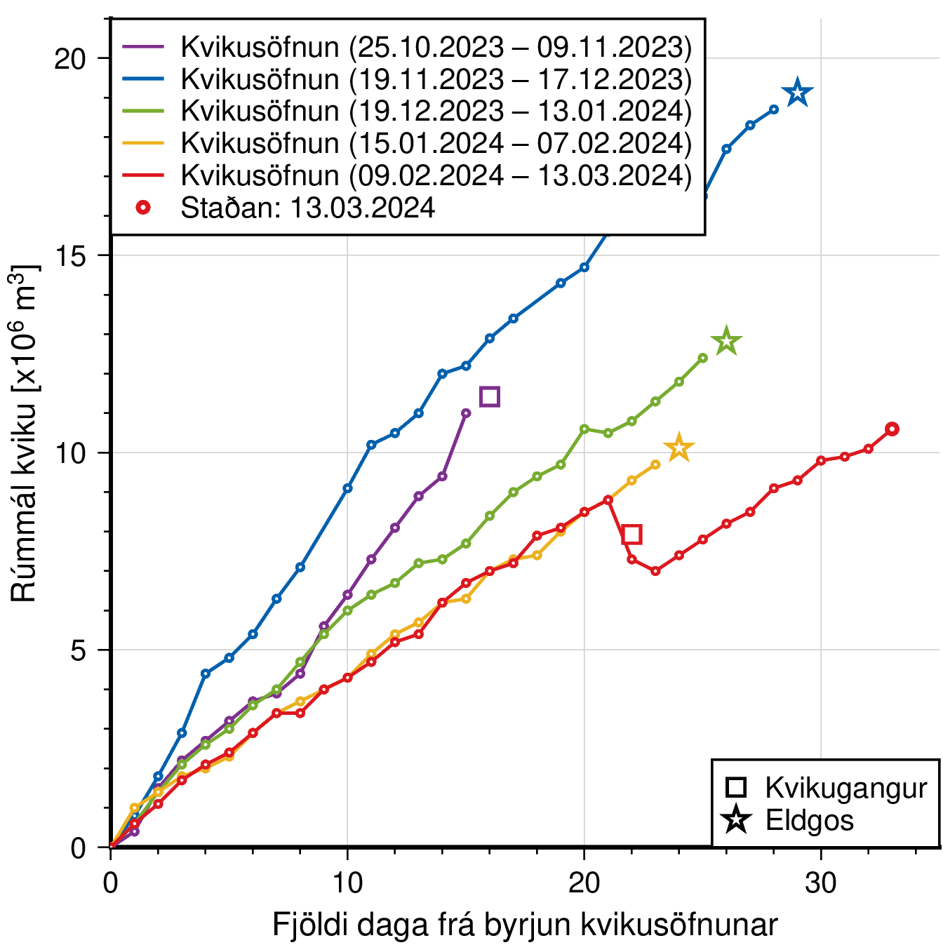
Slug Race with Grimsvötn? One way the system of Grindavik’s volcano has changed. Will the eruptions move west/east to next volcanic system after three eruptions? Will the eruptions change their style? Will the eruptions become weaker, slower and go dormant as some scientists predict?
The more it goes on, the more I think the last intrusion was part of the same sequence, with the next in about 11-14 days.
November -intrusion
December-intrusion with large eruption
December-intrusion with small eruption
January-intrusion with large eruption
March-intrusion
April-?intrusion with largish eruption
It looks a bit like it is alternating, with a filling event and an eruptive event, getting smaller with each cycle. The exception was November, as it needed to intrude the dyke first.
I forgot about the November intrusion. This must be something that has been repeated during early March. The next chance is around Eastern, so possibly a surprising Easter Egg.
It’s possible that the game has change. The rules might have shifted, but we don’t know now, in what directions. The failed eruption in early March falsified the simple hypothesis that the eruptions happen regularly with a constant recurrance time. But the intrusion confirms the hypothesis that intrusions (including the case of eruptions) happen regularly with a nearly constant recurrance time of 20-25 days. We shall see if the style of the next eruption changes. The magma of the intrusion of early March is still in the system and may still play a role in the next eruption.
Next hypothetical assymption: A negative correlation between Fagradalsfjall and Svartsengi. This would mean a high activity of one system during low activity of the other system.
It took two months from Fagradal’s end August 2023 to Svartsengi’s first significant swarm October 2023. If the next Fagradalsfjall eruption is in June, we only have three months to wait. The magma, that begins to flow towards Fagradalsfjall, lacks in Svartsengi’s system. Last year the inflation of Fagradalsfjall began in April. 2024 this must happen one month earlier: March
Interesting geological conditions on Mars! Imagine the Earth without the deep oceans. Rivers of water would cut unbelievable deep canyons in the continents. The Nile wouldn’t have built the delta of Alexandria, but a kilometers deep canyon.
Mars is kind of a “fozen earth” concerning the geological activity. It had some during the young age, but later became a solid planet apar from some volcanic hot spots. The planetary “engine” was likely too small to continue geological work for long time. Earth and Venus have stronger dynamical Cores that still do vital geological processes today … and keep our Earth also biologically alive. Without plate tectonics and volcanism, the Earth would have remained a frozen Ice Planet like Star Wars’ Hoth.
If I recall correctly, the Nile did cut a deep canyon during the Messinian salinity crisis, and it silted in after the Mediterranean refilled with water.
Yes, the Messinian salinity crisis was a “Mars Experiment” on Earth. Maybe the first millions of years on Earth were a bit comparable when sea levels were extremely low. Water was likely first part of Earth’s magma and condensated after the eruptions during “Hell Age” of Earth. Water was likely also added by Asteroids, but the young Earth had enough in its own mass.
Ok so there is a geologist in iceland calling for an eruption in Eldvörp. But after looking through some maps, I need to ask which one?
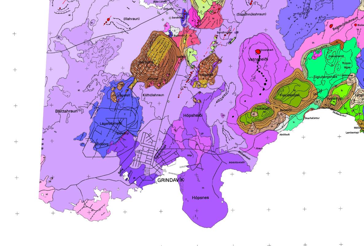
I found this Eldvörp and it lines up with the recent hotspot of quakes. Here is the last week of quakes below.
It also lines up with original dyke pretty much. Which cut through the NW corner of Grindavik. I think there was also previous suggestions in that area.
1210-1240 Eldvörp erupted without any participation of the current Grindavik-Sundhunukur territory. This time the Fires must do the opposite. Eruptions in the Grindavik area without participation of the more western Eldvörp lava fields. The “Catalogue of Icelandic Volcanoes” has a light purple color for the lavas of “Eldvarpahraun” (Eldvörp) that apply to historical Viking eruptions. Dark purple have lavas of previous eruptions, f.e. the Grindavik lavas. Eruptions likely switch every 1000 years between Eldvörp and Sundhnukur/Grindavik.
Interesting this map lables the area of Eldvorp near Grindavik as being older than Sundhnjukshraun. The maps I have seen put this area as the same age but being minor distal vents similar to the southern vent in January that erupted right next to Grindavik. And that map also leaves it unnamed maybe to avoid confusion with the historical Eldvorp craters nearby.
Eldvorp means flamethrowers, maybe loosely it is also meant to mean lava fountains or spatter cones, so probably was named after seeing the historical eruptions make the same sort of thing and putting the two together.
This website has the best maps: https://arcgisserver.isor.is/?lon=-19.00213&lat=65.00348&zoom=7&layers%5B%5D=satellite
It has dates and multiple zooms. Click the 3 bars in the top right corner. There is an option called, “Kortarammar”, click that one. A bunch of boxes should appear. Click the area you want maps. It is slow, but in the top left maps should appear and you can open them in a new tab. there may be more than one map for an area and on the left there will be an arrow to see them.
Also volcanophill, the icelandic volcano catalogue gets it eruption maps from the maps stored in that platform. I’ve been doing some digging and if you need help, let me know.
I believe he said further west, not south west.
This is the Eldvörp fissure system the geologist is referring to:
Thank you, Albert. Those Martian volcanoes still make my mind melt. I wonder if they are truly dead?
Obviously not if they heat up your head
Melt – as in the scale of them! Do you think they are finished?
Perhaps not completely but any eruptions here will be small and far apart
Best not to forget that Martian volcanism is episodic and that between about 200-50 million years ago, most of the Tharsis Province was resurfaced by lava:
https://www.researchgate.net/profile/Bartosz-Pieterek/publication/361582771_Late_Amazonian_dike-fed_distributed_volcanism_in_the_Tharsis_volcanic_province_on_Mars/links/62d02304f819dc50eaaf7ea2/Late-Amazonian-dike-fed-distributed-volcanism-in-the-Tharsis-volcanic-province-on-Mars.pdf
This includes all of Olympus Mons lavas which I’ve crater counted myself. Its landslide aprons are also visibly very young even though I have not crater counted them, the landslides have a low density of large craters compared to Hesperian volcanoes like Syria Planum or Syrtis Major.
Excellent article Albert, and quick work! I only saw the report of the volcano in the science news yesterday.
Giant volcano discovered on Mars (Phys.org, 13 Mar)
I was interested by the jarosite, which is a species that I worked with as a chemist. It tends to need a fairly acidic environment to form, about pH 1. Less acidic than that and you’d more likely get limonite or hematite, like the banded iron ore formations in the Pilbara region. Jarosite is also a Fe(III) mineral, unlike say magnetite which is less fully oxidised.
So it looks like the water in and around the volcano was both oxidising and quite acidic. That’s notable since volcanoes produce SO2 rather than sulfuric acid, and SO2 is a reducing agent.
I don’t know what all that means, but where did all the oxidation come from without oxygen in the atmosphere? Mars soil has a lot of perchlorate in it, accumulated over billions of years due to UV irradiation, but the volcano was erupting early in the history of Mars. Interesting to know if there was free oxygen present in the early Martian atmosphere. That would seem highly unlikely you’d think.
Free oxygen would not be expected. It is safely locked up in rocks, water and CO2. Could there have been hydrogen in the magma?
I believe he said further west, not south west.
Seems to be a definite cornice forming at the newest end of the 4hr Svartsengi crustal deformation chart. Probably more interesting than meaningful. Any small feature in a line that straight is pretty obvious.
All the monitoring equipment will be affected by the weather until midnight according to IMO.
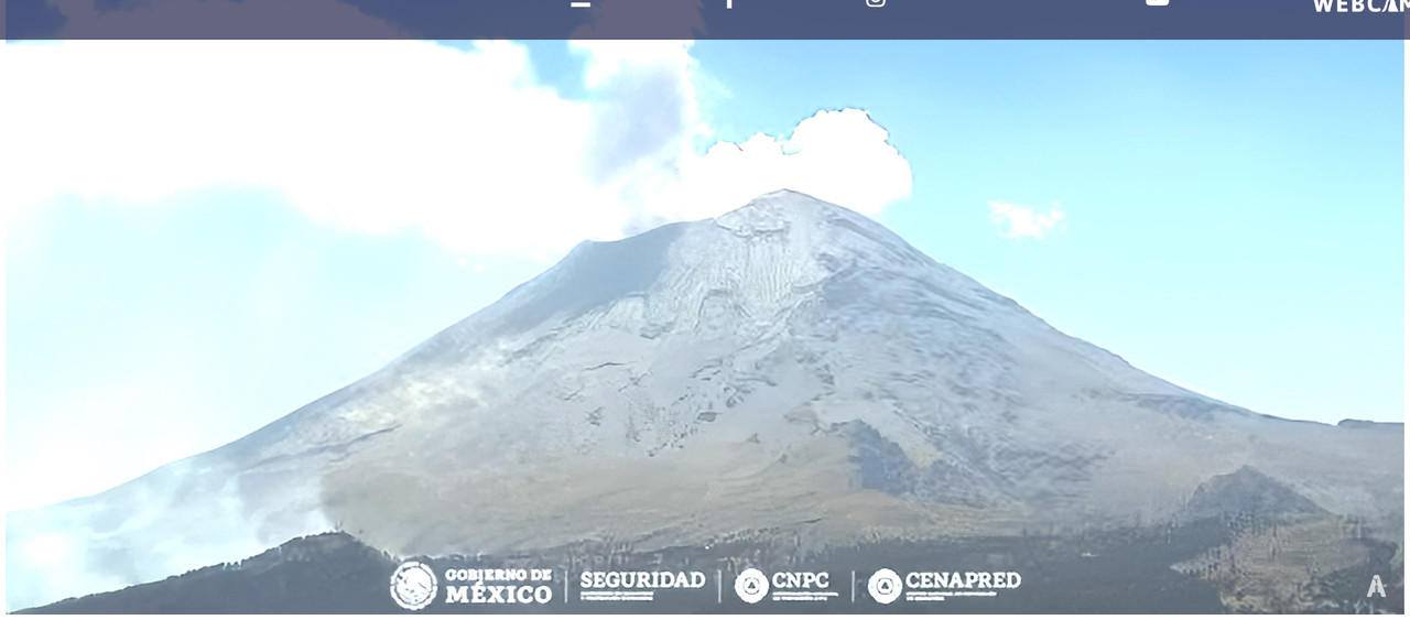
What’s going on at Popo? Is that a forest fire or a flank eruption at the lower left corner of this view: https://webcamsdemexico.com/webcam/popocatepetl-altzomoni/? It is more obvious in the dark of the night.
Can’t find anything on the news. I suppose a fire is more likely.
Given the smoke on the daytime camera, looks like there was a fire. Possibly trees.
We have lift off…
it’s a blast!
best cam atm: https://www.youtube.com/watch?v=YAQzsB9ev9Q
may be the perspective but this seems gushing out wayyyy higher than any of the previous eruptions
from zero to hell inless time than it takes to type this. I hope Blue laggon evacuated. Almost no totice at all. a small bundle of small quakes then WHOOSH!
yeah almost nothing on M1+ leading up to it … suddenly my screen went RED
it was only when i switched to all that I saw the many negative M quakes in the past 15 minutes before
very unexpected onset
I noticed that all 5 gps stations had dropped this morning and half expected this but wow, did it go!
May be the most sudden fissure eruption I know of. Only 7 M 0 earthquakes, then boom.
I think the first eruption fountains were much higher.
*Edit: I’m referring to the one tall fountain of the first eruption, that was the first to break out and was gushing over 100 meters into the air.
full length of the fissure: https://www.youtube.com/watch?v=iKVwD_JZmFA
There we are.
Blue Lagoon cam shows a torrent of cars pouring out of Reykjavik heading to find a way to the eruption!
And it’s also picturesque++
From Reykjavik. Not sure, but it seems that one can see the actual fountains, not just the glow?
From IMO

https://www.vedur.is/um-vi/frettir/jardhraeringar-grindavik
Poeple gathering north of the eruption site (near the main street to the airport).
A guy’s live stream
Update on the fissure location (IMO):
inclined to call it out in proper icelandic:
the soda popped!
we have a flame thrower!
😀
Wow of course I jusr miss the start 🙁
This one is going to have an ocean entry unless it stops very fast, the laca is flowing down to the southeast and will probably very soon be funneled by the barriers right to the ocean most likely within the hour.
So basically, the first eruption on mainland Iceland to reach the ocean in over 800 years 🙂
This will involve testing the Grindavik walls to their absolute limit though, that lava flowing over the road last time was so fluid I wouldnt be surprised if it could erode the barrier should the main current be concentrated right against it. We will see soon I guess.
That flow is really moving.
Chad, where do you get this misinformation from?
From the Husafell webcam, which looks towards Grindavik from the east usually though it is moved slightly now to look at the fountains better. And also exactly as I type this now on the Shawn Wilsey live there is a helicopter view of the fissure showing mostly eastward flow on both sides of Vatnshielði
Ant to update it seems like the lava is actually flowing in all the directions… there is a very strong flow in the same direction as last time too. So maybe no ocean entry this time now better info exists.
One of the lava ‘tongues’ seems to be heading roughly westwards, again. One can see cars on the street to Grindavik.
From the visir stream: https://www.visir.is/g/20242543840d/eld-gos-hafid
From Thorbjörn, looking northeast. One can see the blue laggon, the ‘lava tongue’ in a spooky pinkish color and cars along the street.
This is how far the lava advanced in 20 minutes:
The person who mentioned that there was gas being emitted from the region several days ago has proved to be correct. Just before this eruption about 5 mins before the gas emissions became very noticable. He had good perception and his observation was a good one. The eruption on the LLangihryggur camera started at 20:22:58 pm Iceland time
I had to back track in the previous post-up, to find that the person was “ADAV” who posted 2 days ago.
Thank you. I saw this as well this afternoon so it might very well be a pre-cursor. Unfortuneately I wasn’t able to follow the onset, but what a show it is. Ep. 4, here we go.
This cam is interresting to follow in my mind. It shows movement towards the brim N of Grindavik.
Wish everyone a nice evening.
Good catch!
Quite possibly – I did reply to ADAV as to which area they were referring to as a lot was going on in the previous webcam scene to accurately see. I’m still unsure as to the surface feature with the previous intrusion purely because it never reached the surface.
However, you can see the dense cloud of gases amass along the soon-to-be fissure before the eruption on the cam footage this evening. The initial fountaining height was impressive due to the pressure. It did reduce quite quickly though.
lava tongue now visible onGrindavik Cam.
The only question now is if it flows East towards the sea or west along the berm.
Progression in ~ 20 mins.
(After all not that far away fgrom Chad’s vision, I admit)
And now the second lava tongue enters the scene. An interesting few hours ahead.
This is the advancing lava north of Thorbjörn. The lights that look like cars on a street are actually insects (in cars).
https://livefromiceland.is/webcams/fagradalsfjall
“Grindavíkurvegur is in danger according to Víðis. Then there is the question of how long the eruption will last and whether it will reach the defenses at Grindavík. If that happens, the question is how the gardens will turn out.”
Note sure google got the translation quite right, but it would be typical Iceland. We can suggest some plants that would do well with a bit of lava
(possible exception: the power plant)
:} :} :] Maybe firethorn
I’m growing chilis indoors – fittingly, Armageddon. They’re probably as hot as the lava.
He’s talking about the protective dykes they built around the power plant and north of Grindavík. No gardens 🙂
Plant but no garden.. Pity.
The Times: “eruption spewing molten lava”
they’ll probably also report “flooding wet water” someplace
Haha love it Steve, talk about stating the obvious! My daughter said she would leave me to watch my melted rocks! Seems she has sussed my addiction!
A new cam showing the lava heading toward the berm protecting Grindavik.
Try this one:
https://livefromiceland.is/webcams/thorbjorn2
https://www.youtube.com/live/YAQzsB9ev9Q?si=YJumRkMN6cvSXE2f
On the lower center near the road, there seems to be some steam coming from the ground…
Also, before the eruption, there was quite a lot of steam before the lava busted through.
Thanks Zach, my link works but only if you use Youtube
From RUV: The current eruption is the most powerful so far, says geophysicist Magnús Tumi Guðmundsson, who has just returned from a helicopter flight over the eruption centers. This fissure that is active now is longer, about 3.5 kilometers. Extends from the northern side of Hagafell and north to Stóra-Scógfell. The whole crack is very active.
Based on the speed of the lava flow, he estimates that it will not be long before it flows over Grindavíkurveg. In an hour and a half, the lava had flowed about 1,200 meters to the south, towards Grindavík.
Now it becomes clear how quickly this decreases. Hoping it will slow down quickly. The soda is the biggest so far. Mostly gas coming out of the crater and almost no pyroxene.
He says he hopes that the defenses will protect Grindavík.
On the Þorbjörn close up cam, it looks like the lava has reached the protective berm and is following it to the east.
Or it reached the mound formed by the older lava?
Is that close to the power plant now. It looks like it is closing in one the road to Blue lagoon surely as I can see what looks like the steam from the power plant at the bottom left.
Getting closer to the road now.
https://www.youtube.com/live/YAQzsB9ev9Q?si=D6N0pEkrDMkqqxvv
Just gone over it now as the black smoke would seem to imply.
https://www.youtube.com/live/ax240Imdo3o?si=zpx1NGzMd3C7EHxg
Isak the drone volcanologist is live!
The lava seems to be building up against the berm, and possibly moving along it , toward the camera.
I’m guessing that’s the road into the town ?
Perhaps the Icelandic people can deploy their latest and proven defence against mobile lava sheets: the white wooden picket fence. In the meantime, I’m noticing a slight correlation between the arrival of new articles on Volcano Cafe and the eruption cycle on Reykjanes…
More seriously, I hope Grindavik will be all right.
Map for new eruption from –> https://en.vedur.is/about-imo/news/volcanic-unrest-grindavik
According to the Isakdrone stream, one of its lava flows is going to the power plant, another on other live streams have hit the Grindavik barrier walls.
I’m just looking at the power plant and I’m wondering if the lava stream has overtopped the berm just to the west of the road (north of the plant). Something is going on there.
I guess it ‘just’ crossed the street, but there is a berm along that road too …
Source:
No, the source of the picture is not the picture. The source is IMO.
These are old. It’s way past that and turned south through the berm.
@Clive: Maybe you are right. ON the other hand, isn’t the berm visible on your image as a slightly darker strip?
It’s hard to tell. With it being dark it is hard to estimate the berm line, and I’m working from the police positions south of the berm, on the road.
Maybe I’m wrong (bad eyesight in old age!) If the berms are holding, then that’s great news.
You are right! It’s reaching the berm now. That IS a relief. I was worried for a while.
Lava seems to overflow the Grindavikurikigurikigur street right now.
Source: https://livefromiceland.is/webcams/fagradalsfjall
Flowing fast downhill now it has crossed the road.
Really fast. Downhill and/or new supply.
This now shows that (like Thomas wrote) the lava goes east of the berm in Grindavik.
Source: https://www.visir.is/
Looking on the https://www.youtube.com/live/YAQzsB9ev9Q?si=0kg7HNbt5hXT5PdD stream, the two Grindavik lobes may have reconnected…
Nice video in the RÚV live blog. They managed to nail the actual eruption moment perfectly! The webcam was even pointing almost exactly at where the first split occurred.
Volcanic eruption on Reykjanes Peninsula (17 Mar)
The video isn’t directly linkable but scroll down to the headline “Watch the eruption begin” and enjoy.
Ah here we go, from a different webcam. On YT so it’s linkable.
Its looking like the majority of the fissure is shutting down at the northern end, the only bit with strong activity is feeding the channel that goes past the Grindavik walls. So the Blue Lagoon and Svartsengi area is probably safe now but an ocean entry is still possible. Its hard to tell from the webcams how close it actually is to the ocean though, if it is butting against the walls it is already at least 3/4 of the way but there is still no telltale plume to say it made it.
Interestingly the most active part now is where the dike 2 weeks ago was, so maybe it did open some space and make it easier to go that way even if it wasnt directly where it broke out from.
7:00am and the lava followed the berm east from Grindavik and definitely looking like it is trying to break for the sea.
The only question now is if the eruption continues long enough for the lava to actually reach the sea. It still has quite a way to go as it hasn’t reached the southern road yet.
I am surprised to read there were 700 people at the Blue Lagoon. Grindavik was almost empty and the Lagoon almost full, although the risk level appeared very similar between them. The lava did break out pretty much where expected, but that cannot be guaranteed. One day it won’t
Wonder how long it took to evacuate and for people to completely leave the hazard zones.
Piecing it together from RUV.is and IMO’s website, events were pretty quick. A small earthquake swarm started at c. 19:00. IMO gave the first warning at 19:43 to Civil Protection. A general alert was issued at 20:22 [to the media?]. The eruption started at 20:23.
It was fortunate the eruption occurred where it did.
(Morning!) New cam shows the lava slowly approaching Sudur… street.
Source: https://livefromiceland.is/webcams/fagradalsfjall
To be more precise: It’s not a new cam, still the same cam, but zooming. And the lava is not yet approaching the street and will with some probability never reach the street. Anyway, this view is perhaps the most interesting to watch. On the very left close to the sea there is the often discussed farm, seemingly out of reach for the lava, at least at the moment. If the lava continues it will follow an old lava street (slightly darker texture) towards the sea.
The angle makes it really hard to tell how far it has to go, but the gap in the wall that is clearly visible is 1.5 km from the ocean looking directly ahead in the picture, and the flow front is a lot further back in view than this spot. If the flow is half way along the right wall as it appears to be in this view then it is about 1 km from the ocean.
The fissure has mostly shut down but the southernmost vents between Sundhnjukur and Vatnshieldi, which feed the advancing flow, seem to be going strong and might even be starting to build some cones which is something the last few eruptions didnt really do. The eruption is still probably going to stop within a day of now but that is only about 40 meters an hour needed to reach the sea, which is probably a lot slower than the actual value even if it isnt moving like a flood anymore. If the whole eruption was most intense at this southern segment then the lava likely would have flowed into the ocean almost immediately, within the first 2 hours.
Here is a sentinel image from March 2nd. Viewing direction of the cam is from the top left to the bottom right.
On ruv.is it is said that the lava is 450 mtr from the road and slowly approching. But because the eruption is loosing power it isn‘t sure how far the lavaflow will get…
We will see soon, Isak Finnbogason is out with his drone down near the lava front
https://www.youtube.com/live/EKpsAoqP81Q?si=2Y-Aw8wPnm_XV_c0
Hes also got an electric car so he is driving around powered by volcanism 🙂
Seems to be at this location, where the red dot is.
hj4y4yJ.png

It is still active but moving as a rubbly a’a flow and pretty slow. If the eruption stays at the current rate for another day I dont see why it couldnt reach the ocean but theres a better chance it all stops before that.
I think the lava’s edge is where the yellow line is. One can clearly see cars on the berm (red ellipsis). One car went even further towards the lava 20 mins ago (preparing sausages for the crew?).
The flow looks very slow now, a nearly solid Aa lava flow close to the Southern Coast Road.
I’ve spent a while watching this cam…but mostly because in my mind I’m surfing those waves 😀
They look pretty good !
This eruption had amazing intensity last night. Those fountains must have been what, 250, 300 metres high?
It seems to be the largest eruption yet and has spread itself everywhere fortunately – had it’s flows focused on one area (the power plant?) there could have been trouble. I am glad it erupted where it did.
Not that high. Probably less than a 100 meters.
There’s a very helpful map at the top of this article.
https://www.visir.is/g/20242544020d/-nu-er-allt-ordid-vel-smurt-
And a RUV map which shows the arrows of the lava flow directions:
https://myndir.ruv.is/eyJidWNrZXQiOiAicnV2LXByb2QtcnV2aXMtcHVibGljIiwgImtleSI6ICJtZWRpYS9wdWJsaWMvb3JpZ2luYWxfaW1hZ2VzL3ZsY3NuYXAtMjAyNC0wMy0xNy0xMWgyNG0yMnMwNzUucG5nIiwgImVkaXRzIjogeyJyZXNpemUiOiB7IndpZHRoIjogIjgwMCIsICJmaXQiOiAiY292ZXIifX19
What a suprise, but always the eruptions begin when I can’t watch …
The Husafell webcam shows a good view on the current lava fountain fissure: https://www.youtube.com/watch?v=8bfcTBLvPiM
The lava fountains look more healthy than during the last eruptions. Do they have enough fuel to last longer than the previous eruption?
Its interesting, the GPS at both Eldvorp and Svartsengi have dropped about the expected amount that stopped the prior eruptions yet the southern vents near to Hagafell and Sundhnjukur are still very active. The output is much reduced but that isnt saying much when 10 hours ago it was probably over 1000 m3/s. Actually the output looks a lot like the Fagradalsfjall eruptions, maybe around 10 m3/s or so, which is a rate that we know can be sustained by the base supply for longer. So we might see at least a few days maybe even over a week of cone building and probably an eventual ocean entry in this scenario.
Or it stops in a few hours and back to the waiting game as usual… 🙂
It may well keep going until the sill is largely emptied, which would probably mean a large repose time til the next one. At least a month.
I wonder why its repeatedly ruptured there and southeast of Hagafell, but not the inbetween bit.
Very nice live drone video from Isak Finnbogason covering the Grindavik flow today. Very good and recommendable.
Thx, that’s really useful.
There’s a SO2 cloud in Kamchatka that I had not noticed before. I think it comes from Mutnovsky.
https://maps.s5p-pal.com/so2/
There’s a few odd ones that must be caused by something man-made.
I noticed Saunders Island must be erupting. Marapi giving off a decent plume too.
Taal still pumping out ridiculous amounts despite being in a non-eruptive state.
Surprising amount around Peru – can’t just be Sabancaya.
Poas & Nevado Del Ruiz also at it.
It’s probably Ubinas that’s making the SO2 next to Sabancaya. Usually, Sabancaya puts out a lot more than Ubinas, though.
That particular area could be Opala, Tolmachev Dol, Mustnovsky or Vilikoy, but I think it’s most likely Gorely.
I was just watching the Husafel cam.
https://www.youtube.com/watch?v=8bfcTBLvPiM
Am I the only one that was surprised how vigorous the eruption still is in this southerly end of the eruption? Usually after 24 hours these eruptions are seriously waning and limited to one or two spluttering vents that will die in the next few hours. I personally will be very sad if this eruption goes in the way of these previous rifts and dies overnight. I really would love to finally see an ocean entry in an area that is of no danger to anyones life but just an inconvenience of another road closure without danger to any major infrastructure. Given the Icelanders penchant for rapidly building over lava flows, then even the inconvenience of a road closure for a couple of days isn’t likely to be a major problem. We are having road closures for a lot longer in the UK from floodwaters.
And one of them started smoking heavily, although its very unhealthy.
(Seemingly strong activity may be a deception by the missing daylight.)
Ah, my dreams going up in smoke. As I was well aware it was a dream then I just think, “Such is life!”
But at least the Husafel cam shows vents still looking very lively! I think that southern vent has been the most productive in lava terms anyway.
PS, I dont really expect much to be happening tomorrow, but an old lady still can dream, can’t she.
By the way, does anyone have any news of Jespers progress with his medical issues? I miss him. No one else dares to give me the cheek he does. But then that has ever been the relationship between old and young. Jesper if you are watching please know I am sending you all best wishes for a good recovery.
While they are considering it unlikely, IMO is preparing for an ocean entry of the southern lava flow:
I saw on Isak Finnbogasun’s live video that the police had drones up monitoring the progress of the lava flow towards the sea. So while not expecting an ocean entry for sure, they were certainly monitoring developments. I was so glad to see they had built a berm to protect that lonely farmhouse!
Nil Desperandum as my old mum would say,
https://www.youtube.com/watch?v=Bqudj0x0POA
Billy no mates continues to splutter. Maybe it was hidden by smoke.
There is also a community there called Hraun. They were complaining that the berms whilst keeping Grindavik safe have directly diverted the lava flows towards their settlement. I don’t know if it’s just one family or sort of like a hamlet, but there’s a handful of buildings there.
A ‘billy no-mates’ vent is still happily spluttering away, devoid of any attention:
Obviously one who shuns the limelight. Went into hiding almost as soon as I posted.
see above, it is still there,
I don’t think that’s the same one Alice, – this one is/was even further north, on the right of the view I posted. Was looking fairly healthy earlier too.
The other’s do already build up some pretty nice little (actually not so little) cones.
Word on the street is, inflation has already resumed.
Most of the stations around the sill area seem to be stabilising, but Eldvorp still seems to be on a downward trend. The North and East movement from the intrusion is more difficult to see if it has returned to the general south/west movement. That said, there aren’t many points to see trends very well yet.
Which street?
Threadneedle Street.
It never stopped on the High Street.
Can’t see it for definite. There may be a little on the Svartsengi 8hr plot but this is not reflected in the other plots (8hr or 4hr). We’ll have to see tomorrow.
Geologist Shawn Willsay updates today https://www.youtube.com/watch?v=RM8eJD-0Jiw
Anyone know if there’re live cams for Bardarbunga and Grimsvotn?
4.2 ain’t something to sneeze at.* Especially right on top of a volcano.
* what an odd figure of speech that is.
Are they still Bardarbunga’s post-eruption quakes (caldera deflation after 2015) or are they linked to Grimsvötn’s pre-eruptive state?
I would hedge my bets on this being part of the recharge cycle. Both Bardarbunga and Grimsvotn have had seismic activity that appears conducive to increased magma flow at depth. In Bardarbunga’s case, it will likely be a while until the magma chamber is primed again. The GPS’ on Vatnajokull aren’t as easy to read as the ones around Grindavik – the small patterns in uplift are lost or skewed due to the weather that affects them (snowfall especially). It’s Grimsvotn that looks keen to show its hand soon (relatively)…
Here’s the post-eruption trend at KISA (Bardarbunga) GPS:
Somewhat bizarre pulsing behavior on the Sundhnukar2 web cam, https://livefromiceland.is/webcams/thorbjorn2 at 01:55 am in the morning, the action pulses from right to the left. Very noticeable, but not sure what is causing this.
At first glance it resembled a roating searchlight. I think it’s patches of clouds moving between the camera and lava.
Those same clouds are making the live feed from Hagafell outstanding right now.
My initial thoughts too, until I checked kdenlive (movie composition program) for the frame rate and realized it was properly registering 30 frames per second from the original camera. Then I realized that the timing of the bursts was still the same, clouds or fog or mist or not, so they definitely occurred in the visible sequence in that order. So I think this video has caught some really interesting behavior, regardless of the weather conditions or not.
I don’t know how much hard data they provide, but Iceland’s ability to regularly capture the beginning instant of each eruption is way cool. Plentiful and relatively inexpensive IP cameras and drones seem unremarkable until we remember what it was like without them. While we discuss the intricacies of various drone clips, it’s difficult to remember when a seven second 16mm film clip per eruption (or tornado or earthquake) was all we could reasonably expect.
Inflation starting again already?

This was so unusual, I recorded it. Can anyone explain what is going on? https://youtu.be/E5rZmfyZarI It appears to be a pulse of gas going down the line of vents from right to left.
It’s just those clouds, talked about above, moving through the camera view field.
The clouds did not affect the timing of the bursts.
The active vents are really being very persistent, I wonder if having that failed eruption the other weak might have pushed things apart enough that a more permanent hole could form? The GPS stations are not showing strong deflation anymore and at this point the last 3 eruptions had basically stopped while this vent is still clearly getting fed from the source still.
I wonder if maybe this is going to turn into something like Arnarsetur or Vatnshieldi, or indeed the 2021 eruption, sort of a small lava shield. Its probably way too early to be confident about that but then it must be considered too with the current situation. If this is indeed the case then an ocean entry is very likely if maybe not for a few days, and it is also unfortunately likely the walls will eventually be overwhelmed.
The other option, which is maybe ultimately the same as above with more steps, is that the sill reinflates as normal but with this vent going at the same time. The sill could as a result inflate a lot slower while the vent builds a larger structure, and eventually we either get the fissure split open again (possibly just resetting everything) or it does a sort of Pu’u O’o type paroxysm, basically the same as the fissure eruptions but out of one vent.
Or it stops tomorrow and nothing changes but speculation is fun 🙂
I think now we can say for fairly certain that inflation has begun again at Svartsengi and elsewhere. As you point out the vent is still producing, even perhaps slowing or halting its decrease in flow rate. As the deformation continues upward at Svartsengi it will be interesting to see there is an increase in lava production due to the increase in pressure on the system. I’ve mentioned before that I see Svartsengi as kind of a bourdon tube. Not that it’s linear. Bourdon tube linkages usually have an adjustment for liearity and if there’s a way to calibrate the elevation of Svartsengi for that it’s way beyond my level of tech.