
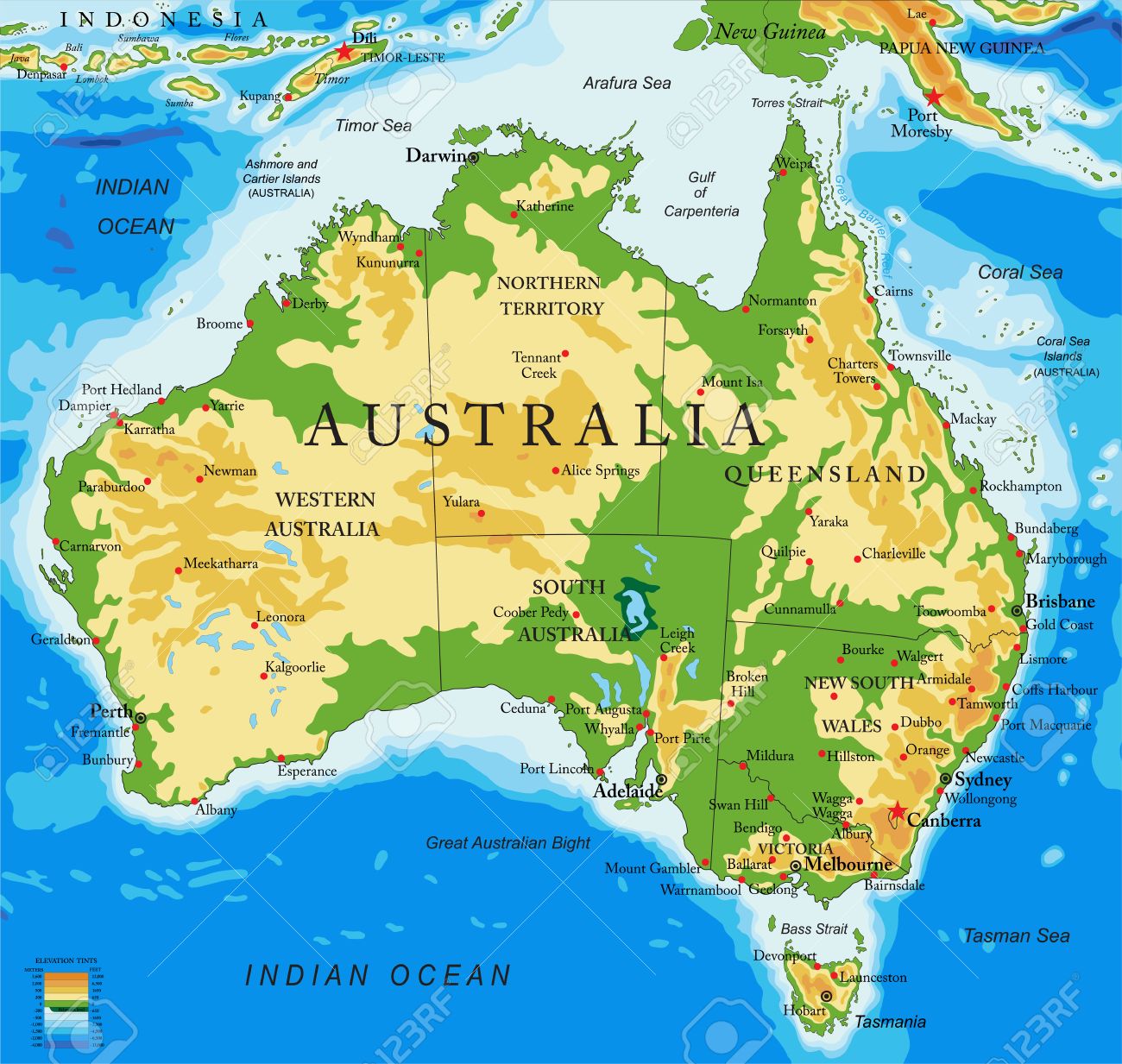
Sydney, with the harbour bridge and the opera house. The Blue Mountains are faintly visible
It is a spectacular city. The harbour bridge and the opera house are instantly recognizable, but scratch only the surface. Once those have been seen, it is time to explore the real city with its dense flocks of boats parked everywhere along the shore, the busy centre with the Queen Victoria shopping centre, the cliff walks along the Tasman Sea (also known as the Pacific ocean), public famousity on Bondi beach, the surfing, Manly (reportedly one of the best beaches in the world), the steep cliffs of the Blue Mountains, the wildlife (spiders, mainly, noisy miners (birds), and some flying foxes fishing in the harbour) (large bats, in case you wondered), an occasional white shark swimming with the swimmers (they rarely bite twice, you will be happy to know – perhaps they don’t like bones in their food either), the white cockatoos which are unbelievably beautiful until they open their beak and make you want to hide, a public transport system that mostly works (the new metro system apart). It is also spectacularly expensive. New apartments are snapped up by investors rather than go to the people who actually need to live here. There is also spectacular dumbness, such as the garden company which stored its mulch in the same area as asbestos, which caused many parks in the city to be partly closed off for health and safety reasons. Live for today – don’t think about tomorrow: Florida man has nothing on Sydney. The narrow streets of the Rocks come with the early history – the walking tour covering this is worthwhile and will explain things such as the smelly origin of the street named the Suez Canal. (Don’t be fooled by the advert saying the tour is ‘free’ – this is Sydney and people worth listening to do expect proper renumeration afterwards). The one thing the Rocks tour does not show well is the rocks themselves. Where they appear, you will see a grey to red rock face with horizontal layers. They are almost always sandstone. The harbour consists of deep valleys incised in this sandstone rock, which go off in all directions. They can make Sydney’s traffic something to behold, held up by the need to cross the frequent waterways using bridges and tunnels – and because this is Sydney, they all cost money to use. But there are bargains to be had. Why pay for a harbour tour when you can take a ferry and get the same views for a fraction of the price?

Sydney is shaped by the sea. People try to be close to the water, in the many bays and inlets or the ocean beaches separated by the vertical cliffs. Wherever possible there is a place to swim, with shark nets for safety. The cliffs come from the sandstone. There are thin layers of a softer, grey rock in between the sandstone. These erode faster, and this undermines the stronger sandstone above. When the sandstone has lost its support, the rock pile can suddenly collapse leaving a straight, vertical cliff where it cracked. Naturally, it is best not to get too close to the cliff edge as one day you will find yourself suddenly walking on air. Everywhere there is a fence along the cliff path, with signs begging you not to venture too close. Wisely, the signs also point out there is help available a phone call away – this is of course to help with mental issues, not rock instability. This is the caring side of Sydney. With all its reputation of harshness and uncaring governance, people here do matter.
The city is surrounded by its very own ring of fire – the bushland around Sydney is prone to fire which can endanger the suburbs. The last summer has been relatively wet and the fire risk is currently low, although recent weeks have been dry and hot, fuelled by the unusually warm sea. Pre-emptive burning of ground cover is being done and there is often a smell of smoke in the air. But other than the perpetual fire risk there is no volcanic activity. There are a few ancient volcanic deposits if you know where to look, but otherwise there is just the sandstone. The distant Blue Mountains consist of the same sandstone and in fact they lack the folding that might be expected in mountains. It is the same sandstone layers, just raised. There are though signs of more recent volcanic activity here as well.
Australia became a haven for an older generation of life, until people arrived and much of it died out, leaving an impoverished ecology. Everything here carries venom, from the obvious Lace lizards (they look like they are best avoided as they come enjoy the barbeque) to the famous spiders and snakes, to the seemingly innocent platypus. Even trees have poison, in one case a neurotoxin. In a previous age, life here must have been exciting and harsh to warrant such extreme protection. But perhaps it was only the venomous creatures that could defend themselves against the human arrivals? Only the kangaroos are venom-free, but they too are wary – and fast.
The land is old. It has seen sea, swamps and volcanoes in its long life. Sydney was once inside Gondwana, far from the coast. Before that it did not exist: this was ocean and the edge of Australia was far to the west. It saw the Great Dying and it saw the departure of New Zealand. It saw mountains rise and erode. These people living in the presence have build on a long past.
Growing up
Australia is an ancient continent; it is one of the old cratons of the world. But not all of it is that old. The west is old – the east is accreted. The border between the old craton and the younger additions is called the Tasman line: it runs roughly from Adelaide to Cairns although the precise location is not well known. Everything to the east, including Sydney (and New Zealand) came from accretion of fragments, terranes, arriving from the eastern ocean. This was perhaps much like how the west of America was assembled. The assembly process took over 200 million years, from 550 to 250 million years ago. This is sometimes known as the Tasman Orogen, but it clearly was not a single episode. Eastern Australia was build by a series of migrants, volcanic arcs of unknown origin.
The Tasman line is a break-up edge of a continent. Which continent is disputed: one suggestion is that it was the break-up of the Rodinia supercontinent, 780 million years ago, while others put it down as a later rifting event. In the Rodinia picture, South China was where now eastern Australia is. It rifted at the location of the Tasman line after which South China went its own way. Later, the vacuum was filled by the migrating terranes, pulled in by a subduction zone running along the coast. In the later rifting proposals, it is not known what parts of the old continent were lost, and it is even possible these were the same terranes that later rejoined. Rifting requires a pull, so this idea also suggests a subduction zone in the east, although more recent than Rodinia. Either way, this subduction zone still exists, but it is now located much further east at Tonga and it subducts a different oceanic plate.
The first terrane to join (ore rejoin) was the so-called Lachlan orogeny. It happened some 500 million years ago, and it formed much of southern New South Wales and Tasmania. Sydney was still missing. That came from a later terrane which joined (or rejoined) in the New England orogeny, which added the land up to Townsville. It also added land further south, but that part was later lost. The New England orogeny happened approximately 300 to 250 million years ago. At this time, for a while a rift basin formed on the western edge of the belt. This became the Sydney basin, running from Sydney almost due north. During the collision there were extensive volcanic eruptions around 300 million years ago but the volcanoes themselves are no longer around.
In the Permian, Australia had a cool temperature climate. The basins became swamps filled with forests of glossopteris which covered the swamps with their leaves. The forest consisted of tree-sized ferns (nothing like tree ferns – these were the real thing), with conifers and huge horsetails. These glossopteris swamps formed the coal deposits of Australia. Coal mining remains of enormous importance to Australia, and the mining companies have major political power. A government trying to oppose them quickly finds itself pressured, or even replaced with a more compliant one. It keeps Australia solidly attached to the past, appropriate for a fossil fuel that is now well past its prime. And it all came from these accretions of volcanic arcs.
Flaring up
The volcanic eruptions re-activated around 260 million years ago, focussed on northern New South Wales, north of Tamworth. This became large event which peaked between 265 and 253 million years ago. It left a sheet of silicic ignimbrites of up to 8 km thick (not in single eruptions, I should say). The ignimbrites were erupted over a 4 million year period. 250 separate tephra layers have been identified in the surrounding basins, reaching 100 meter thickness in the Sydney basin. Four to eight calderas have been identified which may be the origin of the ignimbrites. The total eruption volume is estimated at 150,000 km3 but this number does not include erosion and may be an underestimate by half. This would amount to roughly 0.1 km3 per year. It is one of Earth’s great non-hot-spot eruptions, but little is known about it. The super-eruptions covered southeast Australia in rhyolitic ash over an area of 1000 by 1000 km. Afterwards, massive granite formations were intruded.

Source: Chapman et al. 2022
These eruptions did not stand alone. There were similar eruptions elsewhere around the margins of Gondwana, in China, Antarctica and South America. All of them happened south of the large Tethys ocean. Global volcanic activity waxes and wanes. We currently have a ring of fire encircling the Pacific ocean. There was a ring of fire at this time too, encircling the supercontinent. Was subduction more active worldwide as the supercontinent was beginning to be pulled apart? Did the Tethys ocean have an effect even though the subduction was far from it? Did the emergence of the Siberian hot spot have a role, even though it was half a world away? Perhaps it was just coincidence. Silicic eruptions take many millions of years of preparation, so they are affected not by current conditions but by what happened ten million years before.

The climate had been slowly cooling during the Permian. But 253 million years ago the temperature began to increase. The large glossopteris forests of Gondwana suddenly went extinct just after this time, and coal formation stopped. Was this due to these eruptions? Or was it t the much larger Siberian traps which erupted north of the Tethys?
The climate crisis became a catastrophe. The mass extinction event was much worse than the one which ended the dinosaurs. This was the Great Dying, with life close to being wiped out. In Australia, temperatures rose by 10 to 14C. Death came from unsurvivable heat and loss of oxygen from the ocean: we have written about this here. It has been suggested that mercury pollution caused by the volcanism added to the devastation.
It is worth noting that silicic eruptions are bad for the climate over a couple of years due to the sulfur they may emit (it varies per eruption). This caused the year without summer which changed the human world. But the big climate events came from flood basalts. Why this difference? Silicic eruptions bring out mainly degassed magma which has been sitting in its chambers for far too long. Flood basalts bring out fresh magma, filled to the brim with CO2. Sulphates cool for a few years, until they dropout of the atmosphere. CO2 warms the Earth for millennia, until the sea removes it. Flood basalts erupt over a much longer period than this, with outbreaks perhaps every few centuries – faster than the CO2 can be removed. So the affect the climate over tens to hundreds of thousands if years, building up the global heat. Silicic eruptions don’t do that. Australia is not to blame for the demise of the dinosaurs – although it did contribute to the destruction of its coal swamps: 100 meters of tephra does not sit well with swamp forests. But worldwide, the glossopteris forests did fine until the Great Dying. Death came from the north.
There were further eruptions between Sydney and Brisbane between 240 and 210 million years ago but these were small fry compared to the previous flare-up. They included maars eruptions. The volcanoes of this time are eroded away but the roots are still there: some 30 are known in the Sydney area, not always obvious. Peats crater is one. Another one is visible just north of Bondi beach, if you can force yourself away from that famous beach and from the Miss Bondi Pageant (the word ‘bondi’ may have come from a term for stick fights, so the pageant should be quite a spectacle) to see a bit of ancient basalt. (At the moment much of this particular cliff walk is closed off for reconstruction work.) You may also see some of the basalt dikes from this phase on the other various, spectacular cliff walks along the coast. Don’t look for black: the basalt is too far weathered for that. Look for grey.
Breaking up
After all this excitement, nothing much happened for 100 million years. This is Australia, after all.
Around 180 million years ago, Gondwana began to break up. Australia entered its long isolation, as Africa and India left (following another flood basalt). Antarctica also went, although the latter broke away only very slowly, with the separation not completed until 35 million years ago when Tasmania disconnected from Antarctica. Sydney suffered its own loss: a new rift developed here too and it split off half of the previously acquired New England terrane. This rift is known as the Tasman rift, which formed 80 million years ago and eventually became the Tasman Sea. (Abel Tasman has an amazing number of features named after him, features he was blissfully unaware off. He gave New Zealand its name. The name ‘Van Diemen’s land’ which he gave to one of his other discoveries did not last – instead it is now known as Tasmania. He was however the first to show that the separation of Antarctica and Australia had been completed, albeit 35 million years late.)
Sydney lost rather a lot in this rift. The Tasman rift undid some of the terrane accretion of the past. The lost part of New England tracked back into the ocean and became, appropriately named by Tasman, New Zealand – new land of the sea. But in losing New Zealand, Sydney’s volcanic future became limited. The impressive volcanism of New Zealand would now happen a 3 hour flight away. You gain some, you lose some.
Sydney was now near the sea, for the first time. All those fences and signs on the coastal cliff are really lamentations on the loss of New Zealand.

The loss involved much more than the two islands of New Zealand. A large slice of the continent was sliced off, forming the microcontinent of Zealandia, now mostly submerged. The break started in the south and progressively moved north. The Tasman rifting started close to where Antarctica had not yet broken away. Because the opening started in the south, the Tasman Sea is much wider here. An oceanic spreading ridge started and pushed the parts apart. But the ridge died out after some 30 million years and spreading ceased. Zealandia is now a sprawling empire of the sea, stretching from the tip of the Lord Howe Rise at the Coral Sea to deep in the cold Pacific. A failed rift runs through it: when continents rift, there are often several attempts before one works out. Africa is covered in such failed rifts. Greenland is an island because of another failed rift. So is Britain.
Zealandia is the world’s largest microcontinent – it really should be called a minicontinent. In fact, if any location deserves the name Atlantis, this is it.
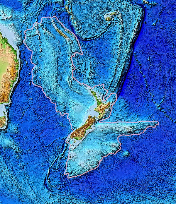
Zealandia (source: wikipedia)
The Tasman rift gave rise to a new phase of volcanism. Most of this ended up on the inaccessible, submerged Lord Howe Rise. However, Australia kept some basalt flows and dikes, which are visible mainly to the north of Sydney, towards Newcastle.
Low-key volcanics
The loss of Zealandia was followed by a phase of intermittent volcanic activity along the eastern coast of Australia. When knowing where to look, the remains of these eruptions become clear. Mount Tweed is a famous one, with a circular valley and a central peak, Mount Warning, which is the remains of the original magma chamber. It has the reputation of being the largest caldera in the southern hemisphere but that story is for the birds. True, it is 40 km in diameter, but false, it is not a caldera. What is on view is erosion, which has removed almost all of the shield volcano but left the outermost lava flows and the central magma, which were the most erosion resistant. It is just over 20 million years old and would have been an impressive volcano at its height, wide but not particularly tall, befitting a medium size shield volcano. This one is close to the border between Queensland and New South Wales. Go in-land, and you’ll find the Warrumbungles, the deeply eroded remains of another shield volcano. This is where you will find the famous Breadknife formation. This one is 16 million years old and lies some 7 hours drive northwest from Sydney. (That is in good traffic – there are days where 7 hours of driving gets you nowhere in Sydney and it is best to start from somewhere else.)

Mount Tweed, with Mount Warning at the centre
There are around 10 of these old shield volcanoes known, plus a number of large lava fields – not always related. The northern volcanoes, in Queensland, tend to be a bit older, at 25-35 million years and the ones further south in New South Wales a bit younger, at less than 20 million years. One of the nearest to Sydney is Mount Canobolas, 250 km west of the city and 13 million years old. The shield volcanoes show an approximate age gradient from north to south. But the lava fields do not. The McBride lava field, the most northerly of the lot, is dated to less than 3 million years ago – some of the lava here may only be 50,000 years old. It erupted from a series of separate vents and volcanoes, active over a very long time. Twenty flows are known to be longer than 50 km and one is a staggering 160 km long. One wonders whether the current Grinadavik eruptions give a hint on how this is possible, with a long fissure erupting intermittently at different places – perhaps. McBride shows that these east coast volcanics have not yet ended, and that lava fields can still form anywhere at any time.
What is the cause of this sporadic but voluminous volcanic activity? That is not clear. The lava fields are mafic, similar to those of ocean islands, but the shield volcanoes are bimodal with both basaltic and more evolved volcanoes. The magma seems to come from the moho, 50 km below the surface. A hot spot has been suggested, of course, and this model is what is listed on most popular volcano sites. But there is no evidence for one, it does not fit the age progression well in particular for the lava fields – and it certainly does not fit McBride. A better explanation is needed. An obvious suspect is the Tasman rift. It is inactive, but remains a region of stretched oceanic crust, allowing heat to come up. The volcanics in the north, where the rift runs closest to the coast, producing less evolved basalt, while those in the south are more evolved and the magma has spend more time underground. This fits with the distance to the rift. And since the rift is inactive, the magma has nowhere else to go!
The full explanation for these spasmodic eruptions is not known. Notably, all are near the Great Dividing Range. Does that have something to do with it? Why are those mountains here anyway?
The strange Blue Mountains
On a hot day, during a ‘Sydney oven’, they are a delight to visit, being quite a bit cooler. On a cool day they are also very nice but don’t take them for granted: the weather is changeable and being wet and cold on a steep cliff side is not fun. From Sydney the Blue Mountains are distantly visible on the horizon, at least on a clear day. There is nothing in the geology here that builds mountains, though. The nearest true mountains are in New Zealand. There is no folding of layers. The land has risen for no obvious reason.
The Blue Mountains are in fact not a mountain but a plateau. As in Sydney itself, erosion of the sandstone has formed deep vertical cliffs in the plateau, canyons that end against an impossible wall. The Great Escarpment is this coast-facing edge, never more than 150 km from the coast, formed by erosion. On the other side of the Range, the slope is much less: the land here lies higher. Charles Darwin thought that the canyons could not have been made by rivers and that at one time, this must have been a sea shore. He was wrong on this. Rivers can do amazing things with sandstone, given enough time. Lots of time.

Wentworth falls, 250 meter high, in the canyons of the Blue Mountains
Your guide will talk about how old the mountains are, and will mention the number of a few hundred million years. But that is the age of the rock, not the age of the mountain. The uplift of the plateau happened long after the rocks formed. Those rocks are rather old, so that doesn’t say too much itself. But when did it happen? And why? And it is not just Sydney’s Blue Mountains. They are part of the Great Dividing Range, which runs parallel to the entire east coast of Australia, bending with that coast line. And it is not only the coastal region. Further in-land the land is also higher. 130 million years ago there had been a shallow sea in the interior, but now the interior (or outback) lies hundreds of meters above sea level. Much of Australia has been uplifted. In contrast, Zealandia has sunk below the sea, even though it consists of much the same bedrock. Something saved Australia from that fate.
When did the uplift happen? The volcanoes provide some information on this. The lava covers part of the coastal plains at 30 meters above sea level. That could not have been the case had this land been eroded since. When these volcanoes were active, the escarpment must already have existed. So much of the uplift must be more than 30 million years old.
Old rivers have been used to study the uplift. Much of Australia is dry now but that is fairly recent. Go back in time and there were plenty of rivers, now eradicated by sand. The drainage patterns can still be seen, sometimes underneath sand, sometimes underneath basalt, sometimes directly in the landscape. From the shape of the drainage basins, it seems that the uplift happened over two phases. The first phase was between 120 and 80 million years ago, and gave uplift of some 200 meters. After 10 million years of quiescence, the uplift restarted 70 million ago and continued until 20 million years ago, with another 200 meters. The uplift was larger in the Great Dividing Range but happened at the same time.
What caused this slow, long lasting inflation? Compression has been suggested. At the moment Australia is caught between plates to the east and to the west which compress it a bit. This is the source of the earthquakes which occasionally hit the country. But this has been the case only since 10 million years ago and does not fit the time when the uplift happened. Magma accumulation underneath the crust has been suggested, and in fact in a few cases the rivers suggest enhanced uplift shortly before one of the volcanoes erupted. But this can only explain a small part of the uplift.
A recent explanation invokes interaction with nearby plates. Before 120 million years ago there was an active subduction zone along the east coast, with Australia situated above the sinking plate. The country would have been pulled down a bit as well. This can explain the sea intrusion. When this subduction ended, there was rebound. The inflation between 120 million and 80 million years ago is thus explained as the rebound from the previous phase of sinking. The later inflation has a different cause: mantle upwelling. In the model, the sinking oceanic plate that had been subducted east of Australia sinks, and displaces mantle material which upwells around it. As Australia is drifting northeast, it gets above the upwelling and begins to be affected by this rising, warmer material. The model does not invoke any hot spot but can explain the inflation pattern across the country – and perhaps even the patchy volcanism. But other models may come about: the discussion has not ended yet.
After inflation comes erosion. The sandstone layers are endangered by some weaker layers that are interspersed, and the ensuing collapses form the cliffs of the escarpment. This gave the spectacular scenery of the Blue Mountains, 120 million years in the making. Darwin had not realized how much time Australia has to do things.
Arrival
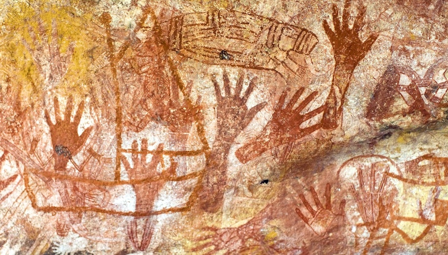
Voices of the past: Aboriginal rock art
And 50,000 or more years ago humanity arrived and Australia ended its long isolation. People quickly spread across the continent. As everywhere that humans arrived, the megafauna died out: what we now see in Australia is greatly impoverished compared to the past. The ice age caused upheaval: Australia dried out and much of it became uninhabitable. People withdrew to a number of refuges along the coast, with the Sydney basin an important one, but the total population plummeted at this time. On the other hand, there were new coastal plains which are now submerged: Sydney would have been 300 km from the coast. After the floods, the Sydney basin remained an Aboriginal habitation. Fish was an important resource to them, as the sandstone does not invite agriculture. Aquaculture was developed: they build fish traps both on fresh waters and on the coast and held the fish there. The local population did not settle in towns: they would move around over months as the local bush would become exhausted. But they were much more than hunter-gatherers: fish farming was a part of their life.
Europe arrived in 1606, on a small ship called the Druyfken. It can still be seen (at least a replica) in Darling harbour – a sailing tour on this ship is offered twice a week and makes for a historical experience. This visit heralded another major change, and a disaster for the first people. It is still notable that while New Zealand is now proud of its Maori heritage, Australia largely ignores its Aboriginal people. It pays lip service to its past but tellingly, people with an Aboriginal heritage may hide this.
And eventually Sydney was build, in a place with 200 million years of spectacular geology. What a place to call home.
Broken Hill
But there is a hidden, deeper history here too. The Sydney region is a recent addition to Australia, as we have seen, only 300 million years old. But in the past, there was a different part of Australia here, one that was lost in the rifting of the Tasman line more than half a billion years ago. What do we know about that past?

Broken Hill
A thousand kilometers west of Sydney lies the town of Broken Hill. The hill it is named after no longer exists: it has been mined to the ground. Here was some of Australia’s richest real estate. Silver was found here, as was lead and zinc, in enormous quantities – it was called Silver City at one point. The broken hill was the tip of the ore body. The total deposits are 7 km long and 200 meters wide, and while at the surface at the centre, at the outer points the deposits lie 1.5 km below ground. It is (or was) the largest such deposit on Earth.
The ore body was formed under water, on a sea floor, in the presence of volcanic activity. The volcanoes were mixed: there are mafic sills but also silicic and even dacite ejecta. The volcanism took place in a developing rift. Because of the felsic ejecta, this must have been a rift involving continental crust – perhaps something like the Red Sea. The volcanic activity brought sulphides into the water, and in the heated, oxygen-poor water these reacted to form metal-sulphides which sank to the bottom. This sediment became the ore body. Later, there was deformation when a batholith formed below the deposit, which shaped the flat deposits into the current banana (or rather boomerang) shape. By that time the rift had long become inactive.
All this happened 1.6 to 1.7 billion years ago. This is the ancient heart of the craton. But a billion years later, a new rift formed at this very same location. The Broken Hill deposit lies just west of the Tasman line: it only just survived the new rifting. The rift happened at the same place as the old one: once a continent develops a fault, this remains a weakness which can always re-activate. The area to the east was lost, and first became ocean, to be replaced by the terranes that joined later. The Sydney area was therefore re-created. Just like the inhabitants of Sydney are newcomers which replaced those were before, the land itself too is a newcomer, a recent replacement for a much older land that was before and is gone.
That is Australia. It is a country that gives the impression that it lives in and cares for the present, with little consideration for the past or future. But there is a rich past here, and one that may help understand the land better. It is worth looking away from the water and see the rocks on which Sydney is build.
Albert, March 2024

Come see the sights! What are you waiting for?

Very interesting article Albert. The traffic, expensive real estate and spiders are a national thing though not just a Sydney thing, unfortunately 🙁
McBride has Holocene volcanism, the last eruption was around 7000 years ago at Kinrara volcano, an eruption that started as a lava shield and had a voluminous fire fountain stage at the end, an unusual progression. GVP has recently added it to the list of volcanoes with confirmed Holocene eruptions.
There are also several volcanoes in the Atherton Tablelands that are under 20,000 years old though the dates are a bit less certain, but are certainly young enough that they were observed. As well as the Toomba lavaflow which is over 100 km long and around 20,000 years old. Massive eruptions at very lengthy intervals are the norm here, Toomba was the first eruption in half a million years from its respective volcanic field. McBride is much more active with at least 5 eruptions in the same interval but still.
McBride is worth a post of its own – perhaps you want to write it? It was a bit off the topic of this post (Sydney) so I did not go into it in depth. The 7000 year age is not fully secure, I think. Carbon dating of sediments in a lake dammed by the flow gives ages of around 10,000 years. There is room for more research! But in either case, this is likely quite young. It is interesting that both studies try to push the results towards their expectation. The one giving 7000 years throws out some date for being too young and likely contaminated by younger matter, and the other throws out some older dates for likely being contaminated by ejecta from the volcano. It leaves me a bit uncertain: you should look at all your data with the same suspicion, not only at the points that don’t fit the rest.
I have tried to write a post on Undara, but there is just basically no info on it at all in regards to iys present activity. The data of the Kinrara eruption being Holocene age though seems to be pretty solid, and is consistent with still black surface of the lava, and the eruption actually being both observed and still remembered in the folk songs and stories of the local Gugu Badhun people.
https://www.sciencedirect.com/science/article/abs/pii/S1871101416300826?via%3Dihub
My suspicion though is that Undara is an actual central volcano or at least an embryonic one. The sysyem is actually very elevated by hundreds of meters above its immediate surroundings and vents tend to operate on a radial pattern atop this bulge. The vents themselves are still monogenetic but evidently there must be accumulation of magma at some depth below the area, though the size of the eruptions should have made that obvious really. But there has never been an actual study trying to explore this potential.
The whole Atherton/McBride/Nulla volcanic province reminds me very much of Payun Matru and the now massive bimodal shield and caldera that has grown over the Payenia volcanic field that also produced very large tube fed lava flows for several million years up to the origin of the shield after about 0.4 mya. The same appears to be the same for Paektu/Baektu, though the volcano there is much more evolved and maybe waning.
One important thing we might see in the future is that both the Newer Volcanics and Atherton fields had a highly active peak volcanism producing large volumes of tholeiitic basalt and at least some true polygenetic shields. This was also at about the same time too interestingly at the Pliocene Pleistocene boundary, but very likely coincidence. McBride so far has been going on 7 million years (but is mostly less than 1 million) and several hundred km3 but still erupts alkaline lava. The crust is actually very thin here at 35 km which is thin enough to get large scale shallow melting and tholeiitic basalts. All of this suggests the volcano is going to be a bit of a monster when it really gets going. Not that we will ever see it…
Basically there is a lot of speculation but not a lot of hard evidence that I would like. I guess the general idea Australia has no active volcanoes has also kind of stopped anyone from having a serious look at if that could be wrong…
I felt that the Aboriginal connection was a bit weak. It tries to fit the expressions around the assumed eruption and a date but would not stand up as independent evidence.
Any attempt to correlate mythology to actual events outside of that areas written history is probably going to fail under the scientific method… Hawaiian history of Kilauea has proven to be pretty reliable for eruptions before the 19th century. 7000 years is a long time but within tbe same millennium that writing was developed that can still be translated, hence is ‘historical’
find it hard to believe an eruption like Kinrara would not have had a huge impact, and it isnt like a fire or a storm that leaves no traces, the volcano is still there to see, so even if the memories wander the core subject is about a physical place, which makes it more robust to distortion over time.
But that is all also irrelevant anyway if the radiometric dating is still indicating an early-mid Holocene age, anywhere from 9000 to 5000 years, nominally 7000. The lava is also still black, it looks largely unweathered like it formed in the same climate as the area is at present which would also support a Holocene age. The older dated flows nearby except Toomba all predate the last glacial maximum, the climate was different back then, a lot colder and at that altitude possibly prone to daily freeze thaw cycles at least part of the year.
We have talked about the dream time stories in https://www.volcanocafe.org/the-green-green-lands-of-australia/. In one case the stories had become attached to the wrong mountain. People moved around taking the stories with them. The stories lasted (for a long time), but the environment changed
That is talking about a story in a completely different part of Australia though, from peoples who would have never interacted with the area at Undara. Driving from Townsville to Melbourne is 2500 km, which is nearly as far as from London to Moscow, and on that journey you get about half way closer to the south pole too. That area is also notorious for fires and any mountain can look like a volcano when it has a pyrocumulus cloud towering over it. There is also the reasonable assumption that someone would have observed the shape of a new and obvious cone compared to an older one and assumed a common origin. The Hawaiians did that and correctly got the islands age progression right before the concept of continental drift was ever imagined by anyone anywhere. The Romans knew the volcanoes of the Chaines des Puys were, well, volcanoes, even though they never saw the eruptions creating them.
Kinrara was also WAY bigger than any of the Newer Volcanics eruptions, and it was a lot more intense. The Newer Volcanics makes mostly scoria cones, and effusion rates seem low though volume can be sizable. There are some large maars though, but only 2 are young enough to have confirmed dates within human habitation. Kinrara erupted about 5 km3 of lava and the last 1 km3 was effectively a flood lava not unlike Holuhraun, its a different scale.
There is the following article which mentions the age of three of the latest, maybe the latest, McBride VF eruptions: Undara around 189-190 ka, Murronga at 153 ka, and Kinrara at 7-9 ka, with uncertainties of some thousand of years:
https://eprints.gla.ac.uk/134886/9/134886.pdf
It would be interesting if the history of the northern Australian volcanic fields was better known. We might be in a sort of surge of activity since the Kinrara and Toomba eruptions were closely spaced, although still 10,000 years apart.
I find Newer much more interesting, though. It has erupted numerous times in the last 50,000 years with enormous geochemical variety ranging from foidites to subalkaline basalts, and various isotopic compositions. Eruption style is also varied, ranging from shields to scoria cones to maar eruptions. And it is also a vast volcanic field with unusual vent distribution akin to Lanzarote and some other volcanic fields with unstable chemistry. Very different from McBride or Nulla, which just erupt homogeneous trachybasalt.
Another Australian rarity are the lamproite magmas of the Kimberley Craton, which at 20 million years old they are the youngest diamond-bearing magmas on Earth, I think.
In a way I find the homogeniety of the McBride lavas to be the interesting part. Newer Volcanics is truely monogenetic, each eruption seems to be totally isolated and fed from the mantle. The abundance of xenoliths in some samples probably means the ascent time is rather short too, though that may not be standard to all eruptions. Most likely the next eruption within mainland Australia will still be in this field.
A largely homogeneous lava composition and significant doming up of the crust to me says there is an actual magma system here, not a chamber per se but the deep plumbing for sure. The volume and long duration at relatively to sometimes very high intensity of the McBride eruptions, especially the enormous Undara eruption, all says there is a voluminous lower crustal storage. Australia is known for its ancient geology but this area the crust is very thin, only 35 km to the asthenosphere, which is the same as central Iceland…
I did make some maps of the area too including an attempt to see if there is any patterns in the vent distribution. McBride is definitively radial, focussed to a center close to the Undara crater. The adjacent Nulla/Sturgeon/Chudleigh (NSC) volcanic field though looks like it could be a wide dike swarm that runs at right angles to the trend of the Great Escarpment. That is only from vent location though, which are typically shields and not obvious fissures, and there are no grabens so it doesnt seem to be a rifting province. But still, the vents do appear to be distributed less than randomly.
NSC though, just like McBride, is very elevated above the local mean, and the amount of erosion in some areas shows this is not a new thing but something sustained for possibly millions of years. The Toomba eruption shows that the area isnt dead too, just active only at wide intervals. The magma source isnt that productive but it is very robust and persistent. And unlike Newer Volcanics which was more active around a million years ago than today, the rate of volcanism at McBride seems to have increased markedly in the same interval.
Both are just eruptions – pick your choice which one appeals more! But my interest is in the massive eruptions in northern New South Wales 255 million years ago. Why did they happen? Why so large? And were there so many around the world at that time, in places that were completely unconnected? Supercontinents are supposed to be quiet places, with nothing much happening until they break up. Is that perhaps not true? Was this an afterthought of the tethys, albeit a hundred million years late? A forethought of the Gondwana breakup, but 100 million years too early? Unrelated? Pick your choice?
And why is there so much venom in Australia? It is a mystery!
The venom is easy, all of the snakes in Australia are part of the Hydrophinae, all Australian Elapids are technically sea snakes, even the Death Adder that looks very like a viper. Sea snakes are all extremely venomous, they need it to kill fast swimming and dangerous fish.
Most of the memes about Australia being full of dangerous are complete myths, if you know anything about our fossil record you know drop bears went extinct in the late Pleistocene and were only half the size of legend 🙂
But that is not true for the snakes, if anything the reputation they have really doesnt do it justice. There is no evolution saving you, if you are an amniotic tetrapod it is literally biologically impossible to evolve a resistance to the venom other than being too big for the dose, and there is no such animal on the earth today that can do that…
Evolving an anticoaggulant that can counter the effects of Aus snake venom… would literally make your blood leak out of your body like a wet sponge, which is obviously no less lethal.
That apparently doesnt stop monitor lizards, or goannas as they are called locally, from frequently eating snakes though. I could actually make a whole extra comment about those too, the second biggest terrestrial reptiles on the planet today and also venomous as it turns out too, but maybe another time. Im not going to talk about Megalania… 🙂
https://www.sciencedaily.com/releases/2017/08/170822092248.htm
The funnelwebs though, that is a complete mystery. The venom is only potent to primates which have never evolved with it, the venom is pretty harmless to all the native mammals.
That last is easy to answer. Spider venom is “targeted” at insects and other small prey, not at large animals. So lethality to mammals would be happenstance. The local mammals came under selective pressure to evolve resistance, and the spiders were under no selective pressure to evolve the venom to evade that resistance, so the local mammals became and stayed resistant. Primates, having never met these particular spiders until an evolutionary eyeblink ago, lack that resistance.
Yes, that explanation works. Are dingos resistant?
Now about that gympie-gympie tree which produces neurotoxins and is reported to be the most poisonous tree in the world to touch. Or the platypus, with a ‘mild’ venom that produces extreme pain lasting for a week or more. What is the story behind that?
Dingoes are not affected by funnelweb venom and neither are pet dogs and cats.
The venom is complex but the bit that is deadly is called delta atracotoxin, which inhibits potassium and calcium ion channels in the nervous systems of arthropods, but for whatever reason it also similarly blocks the sodium ion channels in the nervous systems of primates, and only very weakly or not at all in other mammals. The venom often doesnt have any affects at all on other mammals and this also has no consistency whether the animal is a native species or not, only primates have severe symptoms that are likely to result in death.
https://www.researchgate.net/publication/253816802_The_composition_and_petrogenesis_of_the_lower_crust_A_xenolith_study/link/55ce505c08ae118c85becf8f/download?_tp=eyJjb250ZXh0Ijp7ImZpcnN0UGFnZSI6Il9kaXJlY3QiLCJwYWdlIjoicHVibGljYXRpb24iLCJwcmV2aW91c1BhZ2UiOiJfZGlyZWN0In19
This is a bit interesting, as this contained xenoliths, which came from the lavas of Hill 32 in the McBride province…
https://www.sciencedirect.com/science/article/abs/pii/S1342937X22002763
And then there is a paywalled one here…
Hi Albert, Chad, interesting article. one of the other things perhaps not considered is the action of the Rockhampton volcanic province it would be interesting to include this in the discussion in Eastern Australian volcanism. Ithink the geology of Eastern Australia is far more complex. There is also a line of volcanic occurrences across NSW, some have supposed is as Australia moved over a hotspot. we have (not in order) Nandewar, Kaputar, Warrumbungles and of course Mt Warning.
There are hot spot trails off the coast – the shield volcanoes in Eastern Australia don’t look anything like those clear chains. So to me the hot spot hypothesis lacks the evidence for a chain. The fact that the lava fields do not follow the age relation at all is the killer blow. Another interesting point is that southern Africa also has a uplifted interior with a beautiful escarpment (more impressive than Australia’s, in my opinion, and also much higher). It is called a superswell. But there is no volcanism associated with it. Australia instead has long-lasting volcanism along the entire eastern edge. Why the difference?
The left vent seems to be rapidly overtaking the right vent now, some huge spatter bursts going easily twice or even 3x the height of the cone now, so maybe even 100 meters at times. The right vent isnt dead by any means but not nearly so active at least visually.
Not sure if it is just the lighting either but the lava looks to be more fluid now too, like it did in 2021, so maybe the supply from depth has washed out the stored magma and is beginning to erupt more directly.
I wonder if it was the old stuff that was restricting the flow through the feeder from the sill to dyke? If the erupting lava is now less viscous, maybe that’s why it is now more openwith a continuous feed.
Three vents are still active, with one “King” vent with the highest and largest fountains, one slightly smaller “Queen” vent and a third minor vent. https://www.youtube.com/watch?v=rEMz0hwyfFs
The webcam shows to me, that the lava level has slowly risen. It threatens to drown the vents. They have the capitalistic choice either to grow or to quit. Has IMO measured the altitude above sea level of the current lava pond between the erupting cones? March 16th they published a map with lava thickness, but it needs an update.
The base of the lava field below the active cones is around 70m above sea level. On March 16h the lava field on the flat peak area was 12-14 meters thick. That’s around 85m above the sea. I’d assume that 100m are a roughly estimated limit of the cones around Dalahraun. If the lava level rises until 100m, the cones will get problems to stay alive.
It looks like the left vent is starting to drown but the right vent is still elevated, and with only one vent open the pressure will be a lot higher so harder to close that way. If anything actually the left vent looks more active than before just the height of the cone and the decline if the other vents makes it look like things are slowing down.
I have the impression that two factors weaken the eruption now: 1. The rising lava level of the cones, 2. a slowly decreasing magma flow from the sill. Can the eruption continue until the next pulse of magma arrives or will it finally cede completely?
Would the intrusion of March 2nd, that failed to erupt, lead to a renewed eruption now?
The now very dominant left vent is actually visibly raised up above the channel, there is a spillway at the outflow point. The other vent will probably die out in the next day or at least just be a closed spatter cone but the left vent might as well start high fountaining, it looks like it is trying to already.
Dying is not a word I would use to describe this though…
Indeed the left vent tends to become the dominant vent and to win the “magma monopoly”. When Fagradalsfjall 2021 entered the same stage, we got the “Lava Geysir” with intermittent tall lava fountains. A monpoly cone can do and rise more than a group of rivaling cones. If this stage is entered, I believe that this will be the final stage of the current IV episode (in Star Wars “A New Hope”).
What happens if the eruption continues until the next pulse of magma enters the system? Will there be a wave of voluminous lava output at the same spot or will there open an eruption anywhere else?
That is something I am curious about too. If I had to pick a side I would think the pressure is too great when the sill bursts to have the eruption contained at one vent. But then that was also back when there was no open vent at all, the sill ruptured and then the rift shut again fast, which is obviously not the case now.
If the sill was ready to drain again right now, I dont think the vents would take it all and more fissures would open. But at the rate things are going up now the next potential failure of the sill might not be for a few months, and if the eruption stays continuous that long then it may well be open enough that only the area right around the active cone erupts new, and a high fountain is likely. The longer the vent is open the more likely it is to stay open until the magma supply from depth stops feeding the sill complex. Which, judging from the last cycle, could potentially give us an eruption rather larger than the one in 2021…
I guess another option is, if the eruption actually does stop, then when the next eruption occurs will it be along the Sundhnjukagigar fissures or will it begin at todays vents but at extreme intensity…
They usually publish new volume measurements and flow rate estimations as soon as they have the data. The way it’s done is by using photogrammetry to obtain a new Digital Elevation Model (DEM). This involves flying an aircraft in a predetermined pattern and snapping photos of the ground at regular intervals. The photos are then stitched and compiled into a 3D model to get a high resolution representation of the ground elevation.
The new DEM is then compared with a known baseline, and if you integrate the elevation difference between two points in time over the entire area you get an estimate of the added volume over that time period. The estimated volume change is then divided by the time between measurements, which gives the average eruption rate during that time.
This method requires good flying conditions and a clear view of the ground.
I’m looking for a vertical limit for cone growth. In Geldingadalir/Meradalir we sometimes noticed that erupting cones quit activity, when they grew too high. Gravity likely makes a red line for weak volcanic systems like this. They can’t grow higher than a certain altitude.
The high hills around Grindavik and Fagradalsfjall are likely remains of subglacial eruptions. Water weakens the force of gravity for rising lava masses. So it’s possible that the Ice Age had different physical conditions for cone growth on the Reykjanes Peninsula than the Holocene.
The vertical height of the cone is kind of dependant on eruption rate. Maybe the eruption exactly as is could drown itself but if it becomes episodic the limit is much higher. Pu’u O’o managed to get 150 meters higher than the original terrain (and the peak of the cone offset south of the vent another hundred over that) before the conduit failed and began intruding into the surrounding rift again in 1986. If there isnt an active rift involved then there really isnt a limit up until the weight of the magma itself can make it intrude into the surroundings, and by that point you basically have a basaltic stratovolcano like Nyiragongo or Shishaldin.
It would be wholly unexpected for this eruption to go that far. But in its 3 years of high fountaining activity Pu’u O’o erupted 0.56 km3 of material (0.39 km3 DRE) which is not significantly different to the volumes of the last Sundhnjukshraun eruption nor from Eldvorp and Arnarseturshraun. So I think that is a plausible outcome of this and more so if the vent persists while the sill inflates.
The lava does look less sticky now, and even though the fountains are not so high, the bubbling and churning within the crater looks more vigorous than before. I think you might be right. This could be magma erupting directly from the deep supply now.
Im wondering if the dense cloud that is erupting from the vents now might be related to new deep magma, it did start pretty abruptly and not for a few days after the main fissure eruption. Weather conditions are what makes it visible, it is 2° C and 75% humidity, but the fresh lava does have more volatiles including apparently 1500 ppm H2O in 2021, and 4000 ppm CO2. Might get some very tall fountains if it goes into geyser mode 🙂
The fountains are reaching 75m+ above the crater rim at the moment. Best viewed from youtube.com/watch?v=8bfcTBLvPiM due to the wind direction.
It would be interesting if it starts doing fountain episodes. With the shallow magma storage backing up the vent, the sill and dike bodies, the episodes could involve high eruption rates and important volumes.
Focusing into one vent is to be expected, regardless of whether the eruption is weakening or not.
I’m not sure if the sill and dyke would have so much influence on the fountaining. The episodic fountaining during Fagradalsfjall 2021 is thought to have been driven by the presence of a very shallow cavity that formed when the feeder path to the first two vents, 1a and 1b, suddenly collapsed. Visitors in the area talked about a loud thumping sound preceding the sudden shutoff of vents 1a and 1b and then the episodic fountains started.
Figure 3 in this paper illustrates the mechanism. Between episodes, dense, outgassed magma drained back into the cavity. Foam started to build up in the roof of the cavity, until it could escape through the conduit to start a new fountaining event.
https://www.nature.com/articles/s41467-023-42569-9
I don’t see how a sill at 5km depth would change anything if the same conditions as in 2021 would happen again. I do agree that it would be interesting to see it happen again though.
By the way. During the brief moments when the gas clouds clear up and we get an unobstructed view of the cone in bright daylight, don’t the fresh spatters look all bright and shiny, just like when the composition changed in 2021? Hagafell cam at around 11:05:30.
More of a comparison to 1980s Pu’u O’o than to the 2021 eruption. Pu’u O’o was fed by Kilaueas large shallow magma chamber and so its fountaining episodes were huge, lasting about a day and as long as 3 days in April 1984 (only a few weeks after Mauna Loa too, maybe related?). The intensity of eruption at Pu’u O’o during these episodes was enormous, probably exceeding even the highest eruption rates of Svartsengi we have seen so far and it all went through one vent… 🙂
Eruptions were commonly close to 10 million m3 of lava and most episodes lasted less than 24 hours.
If the current vent at Svartsengi declines to an open lava pond and the sill starts reinflating, then it might be best to prepare for the worst because the vent might just go full geyser mode and the longer the wait the worse the outcome… The Pu’u O’o flows advanced multiple km in a few hours or even faster in most episodes, more than the distance to the ocean from the vents near Hagafell. Let alone the real possibility of the lava overflowing the walls into Grindavik now the flow field has backed up against it.
There are actually quite a few similarities between
Did Pu’u O’o have an open lava pond during the fountaining episodes? I thought the pond formed after the fountaining had finished and it went continuous effusive instead. Relating it to Svartsengi, the current eruption probably needs to stop for a few weeks to allow the sill to refill, and then it’s probably more likely to do a new fire curtain.
Yes it did, not always visible but the vent was always open to air between fountains and lava lakes at shallow depth were often observed in the days leading up as pressure rose.
https://hilo.hawaii.edu/~kenhon/GEOL205/puuoo/puuoo1.htm
In theory too, Pu’u O’o could have resumed fountaining in the right conditions probably at any point up to 2008 when the summit took over degassing. The fountains stopped in 1986 because of fissure eruptions on the side but that had happened numerous times before too, even with a week of shield building after a fountain in 1985 that stopped and reverted to fountaining again as though nothing happened… the conduit got too wide, but if something happened to allow it to narrow again. At Mauna Ulu that actually did happen, it started high fountaining again in the last 2 months of the eruption.
And then there is Etna, where it appears no flank eruptions are capable of destroying the SEC complex. 2021 had the tallest lava fountains ever recorded in the historical records of anywhere at any time, with 8 fountains that year exceeding 2 km by a considerable margin. And a 5.6 km tall fountain in early February 2022 yes that number is real…
Basically high fountaining is kind of complicated, and a passive eruption can intensify into a high fountaining eruption in the right situation. And a high fountain is basically 90% of the way to a plinian eruption, it is the same thing just the fallout is too heavy to be lifted by the updrafts and also usually lands as a liquid. It will be interesting to see if Grindavik will have a new mountain backdrop this time next year.
Yes, I meant it as in they could be like Pu’u’o’o and Mauna Ulu. Drawing a substantial amount of magma very fast from the sill during the fountain event, then having an extended quiescence before erupting again. But to be honest, there is nothing like Pu’u’o’o in Reykjanes, in the sense that Pu’u’o’o is a large pumice cone formed from high fountain fallout.
And I mean the longer episodes that last hours or a day, not the short gushers/geysers.
The lava geysers are a sign of an eruption that is stable but working at insufficient pressure to keep going all the time. In Fagra I, they were part of the declining phase of the eruption.
I will finish reading the post in the morning I need my beauty sleep. I had been collecting rocks from parts of the area I am living in, it is a volcanic field, I have problems with wombats, they dig under homes and leave holes in the ground, so the owner put my rocks to use fill some of them up, was not impressed, but also have lots of snakes here, not a problem, just stay out of the way, I know where they live and leave water along the fence line in dry periods, don’t take the dogs for walks along the creeks/river in the afternoon, good thing so they hibernate and are due to as soon as it cooks of for a bid., Platypus live the river, no problem there, Kageroos, Wallabys, deer and wild pigs can be confronting at times, Echidnas are shy cute little ones. Lot of Birds from all sizes from wrens to Wedgetail Eagles at different parts of the year,
Sounds wonderfully wild
Superb article! Thank you Albert!
An exciting journey through Australias geology and of Australia over the oceans!
The hottest continent of Earth Australia and the coldest continent Antarctica were once together. It’s interesting to remember the common roots of a “family” of continents, here Australia, Antarctica, Zealandia, Madagascar, India and Eastern Africa. This family has one thing in common: A fast divorce and voyage over the planet. The quick Indian voyage created in the end the highest mountains of Earth, and the current Australian journey towards the north begins to create the orogency of Indonesia and New Guinea.
The opposite to this divorce has happened in the Arctic North: The accumulation of continents in the northern hemisphere. Over their lifespan, the continents migrated north and encircled the Arctic Ocean. Didn’t even Baltica and Avalonia (English-Dutch microcontinent) started in the southern hemisphere? The geology of Europe mirrors in part the voyage from the south over the equator until the present temperate climatical position (which also facilitated by a cool global climate).
Visitors at around 13.25
https://www.livefromiceland.is/webcams/fagradalsfjall?1711459582207
https://mastodon.social/@RagnarHeidar/112162535863527070
The swarm was on the NW edge of the Caldera, while the lake sits in the center. Maybe there was a small intrusion into the ring fault. The 1920s eruptions mainly occured on different parts of the Caldera Ring Fault.
Albert:
Thank you for that informative article. I appreciate that you take the time to carefully explain crustal movements. I have a question, since there are gold nuggets found in the Australian outback near Sydney. Are gold deposits a good way of locating the ancient volcanoes and a possible way to trace the collision and accretion of the terranes?
There is no direct relation between gold and volcanoes. Gold is transported by water rather than magma. However, underground heat can help in this and also help dissolve gold from the rock. So a volcano would be more like a side effect and not a requirement. The nuggets near Sydney presumably came from the Blue Mountains.
Thanks Albert.
Interesting article, as always
Could Pacific subduction cause the volcanism in Australia – much like further north in Asia at Paektu/Jeju etc.?
I’m not sure how far the Pacific plate has subducted in the south-west corner in comparison to the north-west where slab-pull appears to be strongest. It could be that the Ozzie plate has been suffering an upwelling by being hydrated from underneath.
Atlas of the Underworld shows the ‘Welford’ anomaly at around 430km depth – roughly 26-20ma underlying NE Australia, as well as the ‘Papua’ anomaly (which appears to be the older stage of subduction chunk of the same slab). This subduction appears NE/SW trending beneath Australia and the New Britain arc.
I have seen a paper that proposes exactly that actually, although I forget the spurce unfortunately. The same idea has also been proposed for the Siberian Traps too I believe, subducted slabs buckling at the upper/lower mantle boundary and releasing hydrated minerals. Subducted oceanic crust chemically reacting with the outer core at the core/mantle boundary has also been proposed to be the source of Hawaii.
There is chemical evidence for hydrous melting and water contamination in the Siberian Traps eruptive products, while the area as a whole showed precious little uplift (and in some cases subsidence) during the time of the flood basalt event. A mammoth event that we still don’t fully understand!
The Siberian craton is very old and thick but it does have a long history of magmatism and reactivation. Some 15+ LIP events in and around that we know of. I would love to understand why it erupted some voluminously.
Article suggesting Santorini did a VEI 5 in 726 AD, though one where the eruption products mostly stayed underwater in the caldera: https://www.nature.com/articles/s41561-024-01392-7
Given that big eruption off Mayotte in 2018 I find that entirely possible.
Fani Maoré was a borderline VEI6 although predominantly effusive. Not talked about very much!
That largest vent is throwing more lava out to its sides than it was three days ago. It’s building an absolute unit of a splatter cone.
The lava pond spills over over the lava field on both sides. It also looks as if the lava field grows in breadth
https://www.youtube.com/watch?v=rEMz0hwyfFs
Also Húsafell webcam shows expansion of and lava overflow on the lava field: https://www.youtube.com/watch?v=8bfcTBLvPiM
Today IMO has published English news that confirm my observation that the lava field is growing in breadth. Observation by satellite shows “the widening of lava field towards the west, south of Hagafell, as well as further lava advancement towards the east and the south of the active vents.”
The main threat for humans is currently a high, very unhealthy SO2 concentration. Yesterday they observed 9000 mikrogram/m3 in Grindavik. That’s why video and photo makers better keep distance.
Getting hit with a cloud of SO2 is the most painful thing I’ve ever experienced. I used to commonly clean up H2S gas wells (170k ppm) to flare pits after stimulation. We had a helicopter leaving and that channeled wind around some heavy equipment on an otherwise windless day. We learned to stop breathing mid-breath and mask up as soon as we felt it – that happened reflexively after spending much time at all on these blowback/cleanup sites. With SO2 the pain quickly makes the odor inconsequential. That time, I thought I had adequately air-purged my mask before I resumed breathing. Nope. Took my legs out from under me like I was hit by a skateboarder. That pain has to be right up there with Bullet Ants and Bullhead Catfish barbs.
To all:
I was curious about the exact details that the Iceland Meteorological Office used for deriving their maps of lava flow volume changes using aerial photography or photogrammetry so I asked them.
I received a wonderful prompt reply from Ragnar Heiðar Þrastarson who is the GIS Coordinator.
Basically this is what he said:
The IMO uses mostly aerial photography to acquire the stereo images for the DEM (digital elevation model). They have used similar methods from high resolution satellite images from the Pléiades constellation in the past. Drone are also used for parts of the lava field.
But he stated that the IMO prefers covering a large area around the current eruptive zone, due to the large amount of deformation around Grindavik, making “geo-referencing” to the previous data sets difficult (unless the cross referencing is done far away from the deformation zones)
He has provided some scientific information about their aerial photogrammetry acquistions, based upon eruptions near Fagradalsfjall, but added that they have upgraded their Hasselblad camera to a full-fledged PhaseOne unit with all the necessary items to do ortho-imaging.
Paper describing processing:
Volume, Effusion Rate, and Lava Transport During the 2021 Fagradalsfjall Eruption: Results From Near Real-Time Photogrammetric Monitoring
https://agupubs.onlinelibrary.wiley.com/doi/10.1029/2021GL097125
Datasets gathered during the the Fagradalsfjall erutpions:
Automated processing of aerial imagery for geohazards monitoring: Results from Fagradalsfjall eruption, SW Iceland, August 2022
https://zenodo.org/records/7871187
Digital Elevation Models (DEMs) and lava outlines from the 2023 Litla-Hrútur eruption, Iceland, from Pléiades satellite stereoimages
https://zenodo.org/records/10133203
(Personal note: these data sets are very interesting to me)
I wish to thank the IMO for their prompt and professional reply. THANK YOU!
Askja currently undergoing the highest inflation in the world…
In an area the size of a snooker table.
#superlative
https://gnss.vedur.is/ is not working. Do you have an alternative source for inflation data of Askja?
Try this:
http://brunnur.vedur.is/gps/askja.html
Yes, thank-you! It’s working and OLAC station shows well the sudden increase in March.
Maybe Askja is going to do the eruption that Grimsvötn has failed to do. We lack the scientific seismic record of 1961, because professional instruments were installed a few years later. Next Askja eruption can become a “quasi-experiment” to find out its precursory signals before an eruption.
1961 is the type of eruption with the highest probability on Askja (75%) with a volume below 0.1km³
“An eruption of this type could last for hours to a few days, featuring a short lava fountaining phase with minor tephra fall. Peak activity will not necessarily occur at the beginning of the eruption. The maximum downwind distance of the 1 cm tephra isopach is unlikely to exceed 5 km from source.”
https://icelandicvolcanos.is/?volcano=ASK#
There have been some pretty big collapses on the cone today in Iceland, I’m curious what exactly happens to those huge chunks once they fall back into the lava pond. Do they just re-melt, or break up and get thrown out? Sink to the bottom of the pond? Those pieces are huge, and they just disappear into the pond without a trace, which is pretty amazing it’s that deep. If there was a big enough collapse, could those chunks block the vent?
I think a lot of them get dragged down the lava channel at the bottom, sliding on the viscous channel bed while the fluid lava flows over and around. Sometimes they break the surface and get called lava boats 🙂 there are lots of videos of this at Kilauea in 2018.
The lava has a splashing pattern that constantly coats the inner walls and less often, bursts that build the outside walls. The inner walls will keep encroaching inward until calved by the heat. The frequency of the calving will depend upon that heat and the adherence and viscosity of the lava. I’ll bet someone has studied it to the point they can use the average diameter to gauge the calories produced quantitatively.
I was blessed to see the same effects on a small geyser at about -30 C. It was long enough ago though, that I don’t remember whether it was at Yellowstone or Thermopolis.
The cone is build of fluffy, low density material. If it falls into lava, it floats. That is what causes the lava boats. But a large block will still stick out quite far under water, sorry, lava, so like an iceberg, can easily get stick on the bottom. Sometimes it blocks the flow for a bit. But tese blocks are not strong an tend to fall apart. The debris then floats down the lava.
There’s a minor breakout shown on this camera: https://www.youtube.com/watch?v=rEMz0hwyfFs.
The camera shows well the rising “hraun” (lava field). Lava is stored on the “peak” of the lava field instead of running far away. A sign of decreasing strength? A strong effusive eruption would still support long lava flows/tubes away from the source.
Not sure if it has been posted already: IMO published a new map about the lava flows, covering the period of March 20 – 26:
It clearly shows the spread of the lava South of the cones and the areas that are newly covered.
Massive collapse on the cone’s inner rim at 23:05.
B Bound:
I believe your post 100%. I wish that somehow the websites displaying the live data would allow 24 hour archiving so that we can drop back in time and see what event occurred. As far as I know, Live from Iceland does NOT store the previous 8 hrs of data (I wish it were 12 hours or 24 hours)
Are we going to have to carefully record these websites in real time, then repost?
– Randall
Live from Iceland stores 12 hours of video on its YouTube channels, like all of the other YouTube videos. Check the link in my comment above.
Actually by looking around on the home page Live From Iceland does have a menu bar titled “Timelapse” which is the stored video. This is not YouTube, but their own pages. My firefox browser was set up to go to the actual live camera webpage. Sorry about my miscue, it is my mistake. Thank you Vito for correcting me.
Okay, after spending over 1/2 hour on this, I need to make some more comment. #1. The Live from Iceland Timelapses for the Sundnukar Camera #2 is only 2 hrs 24 mins in length and not timestamped. The youtube version is 12 hours long, but I ask all of you to look at this video snapshot that I took and you tell me what time it is? . I could NOT even see the timestamp on the regular video screen or the theatre mode screen which youtube offers and the timestamp was still incredibly hard to read on the full screen mode. I had to play around with the 5 secs arrow buttons to try to locate the cone collapse and I didn’t find it despite paging through scores of video frames. Add to this that Mozilla firefox went unstable on me and I had to terminate the program. For some reason this simple task was not simple for me.
I do appreciate that Vito called my attention to the YouTube archiving version of Life from Iceland. Now if I could read the timestamp.
Looks like 21:04:57 to me.
It’s more legible at 720p and above.
1:26:10 Too
https://www.facebook.com/share/p/i3iMcCeXmxeEW9vR/?mibextid=A7sQZp
Seems most of the lava flow activity is now under the flow crust woth open lava only around the vents. So probably quite unpredictable to tell exactly which way the flow will go next although it looks like most of the breakouts would be directed along the barrier to the ocran near Hraun if they were to capture the output.
Im surprised the other two vents are still going at this point, they looked to be declining quickly in favor of the left vent the other day but apparently not…
Are the anti-lava dams in danger to get a breach by the weight of lava? In this case lava could flow like a red glowing lahar towards Grindavik’s port …
Kilauea seems to be having a surge in magma supply, up 5 microradians in about as many days, or about a million m3 of magma a day being added to the magma chamber, similar to the eruption rate of the vents at Svartsengi 🙂
Of course it is reasonably likely between half and 2/3 of that will drain out of the magma chamber at some point soon but it is also a trend that eruptions often begin during this sort of high supply. There have been a lot of quakes at the start of the SWRZ connector and scattered quakes all the way down it, maybe magma is going to start filling the area again rapidly.
I have wondered if after the February rifting on the SWRZ, if another dike will be much more readily created with there being a weak spot as we have seen at Svartsengi now many times, and which Kilauea itself did in the 1960s on the ERZ. Maybe the 1974 and 1981 dikes never repeated because of the open ERZ which is not a factor today…
https://www.usgs.gov/media/images/electronic-tilt-k-lauea-summit-and-east-rift-zone-past-week
Yes, I was going to text about the surge. The volcano has been relatively quiet for a while, but maybe this surge will heat things up. The increased inflation is not limited to the summit, SDH has been climbing relatively fast too.
So 5 microradians of tilt at UWEV and 10 at SDH. Its a shame the mounts insar data is down as I expect there is significant uplift in the south caldera with how many small quakes are happening there.
The summit hasn’t compensated the loss of January/February by the major intrusion.
But the SWRZ looks like a loaded gun. The intrusion that let the stations inflate, is still there. Station MANE shows this:
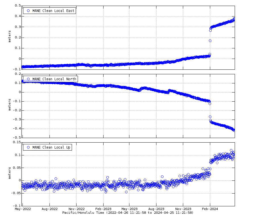 ?fileTS=1711581490
It looks as if SWRZ only needs a small magma inflow to make a moderate eruption.
Yes that is the unknown variable, Kilaueas eruptions are set off by the summit but the rifts are also somewhat independant. If the rifts are open to a lower elevation then eruptions could happen there when the summit looks like it is in recovery mode. That being said even though the GPS at the summit hasnt recovered to before the last intrusion it is above the level that set off the eruption last September so I dont think we should be discounting an eruption even in the near future really, being drained of magma is only really in a relative sense.
That’s an elastic rebound from the dike intrusion, the rubber snapping so the land to the sides contracts and rises, not representative of magmatic pressure in the SWRZ. OUTL GPS is on top of the SWRZ sills and is probably the most representative of the rift zone pressure. OUTL has only recovered 1/4 or so of the magma that drained in the major February dike intrusion. A similar thing happens to PUHI, which is over UERZ sills. UWEV (representative of Halema’uma’u) has seen more recovery but still has a way to go.
What do stations on SWRZ show? There are two stations on the map that don’t reveal their results: KOSM and CNPK. They sit between the Summit and Mauna Iki.
An article by Dr. Erik Klemetti-Gonzalez
https://www.discovermagazine.com/planet-earth/eruptions-in-iceland-going-strong-after-almost-two-weeks
Nothing we don’t already know, but nicely written up.
I see he estimates the current lava flow as “350 large oil tanker ships.” Please remind me, how many full-sized Olympic swimming pools is that?
That’s quite easy. The volume of a typical olympic pool is roughly 2500 m3. Using the estimate of 20 Mio m3 erupted, it means that the lava volume equals the size of 8000 pools.
But how many double decker buses? (With the windows shut obviously)
What is a ‘typical’ olympic pool? The length is standardized but the volume is not
O.K. Back to cubic meters, I guess. (Sigh)
My all time favourite has to be when Kilauea was throwing around fridge sized refrigerators.
I’m just wondering how long until a great surge of lava breaks south. By March 20, there was a broad area south of the vents with 6-12m thick of lava. Then the last week has just been more piling up in that same area… Must be a lot of rather liquidly stuff in that perched pond.
There is also the old Stone Pit of Grindavik which is burried now by liquid stones. Maybe something for Grindavik to dig again in distant future …
But this artificial depression means that there is an over-average accumulation of lava. If it it’s full, it may overflow and change the path of future lava. Maybe this Stone Pit saved Grindavik and the Greenhouse for a while, because it could store a lot of lava.
I think that in the longterm Grindavik is lost. If it were water floods, they would pass into the ocean and then a dam would have the chance to protect against the next one. But lava floods don’t pass away, but stay and build clusters. Sooner or later the lava will overcome the lava barriers. The situation of Grindavik reminds to lost North Sea islands like “Strand”, where people during the Middle Age tried to build dikes agains the North Sea storms, but lost in the end during the Buchardi Flood of 1634.
Sentinel 2 view from 27. March
https://i.imgur.com/EZxU2SD.jpeg
It looks as if moss fires occur around the lava field. I didn’t expect such to happen during this season. It’s difficult to distinguish between smoke from moss fire and gas/dust/steam plumes from lava.
I would assume that the red spikes radiating around the 10 deg angle to be an image artifact but I am glad to see that the degassing fumerole is visible in this photo (the red spike almost points to it) as ground video has shown extensive degassing has recently occurred with harmful SO2 levels in the area. I am curious as to what is causing this particular fumerole as it seems to be mostly steam.
There was another substantial landslide on the inner right side of the cone at 14:28 Iceland time.
Was Askja’s 1875 Iceland’s last VEI5 eruption? According to GVP Katla 1918, Hekla 1947-48 and Grimsvötn 2011 had VEI4. Is there apart from Örafajökull currently any Icelandic volcano able to do a VEI5?
Earth Magazine states “The largest eruptions in Iceland’s history took place at Hveravellir in A.D. 950, Eldgjá in 954, and Laki in 1783 and 1784; each of these registered at 6 on the Volcanic Explosivity Index (VEI). Eruptions at Öraefajökull in 1362 and Askja in 1961 likely came in at 5 on the VEI.’ URL: https://www.earthmagazine.org/article/where-fire-freezes-all-eyes-ears-and-instruments-icelands-volatile-volcanoes Hekla is mentioned by Wikipedia ” Hekla (H3) is considered the most severe eruption of Hekla during the Holocene. which threw about 7.3 cubic kilometres (1.8 cu mi) of volcanic rock into the atmosphere, placing its Volcanic Explosivity Index (VEI) at 5.” Hope this helps.
Earth Magazine got a lot of things wrong here.
Hveravellir did not erupt, but is part of the same system that erupted a large lava shield called Hallmundahraun. That was an effusive eruption that didn’t produce any significant amounts of ash. I couldn’t find a VEI, but it’s probably VEI0 or VEI1.
Laki counts as a VEI4, not 6. VEI only considers explosivity, not the amount of erupted lava.
Askja in 1961 was small and effusive only. They probably mean the 1875 eruption.
Was going to say this, Icelabd has a lot of large eruptions but high VEI numbers are not in abundance, because that only measures tephra volume not the total volume of magma.
There is also, as always, a total lack of any consideration to the intensity of the eruptions. Veidivotn 1477 erupted 10 km3 of tephra and probably at least 1 km3 of lava too but if it did that over 6-12 months like is typical of Vatnajokull rifting events then the average eruption rate is relatively low, certainly not beyond what a lot of intense effusive eruptions are like, and indeed what most prior Veidivotn eruptions had been. Compare to Hunga Tonga Hunga Ha’apai which erupted a similar volume of similar magma in 2 hours… Or to keep with rifting events and avoid calderas, Tarawera erupting 1 km3 of tholeiitic basalt in 6 hours.
Oraefajokull does seem to be the real deal, and at least before 1104 so was Hekla, but all the other high VEI Icelandic eruptions seem to be basically effusive eruptions that erupted into a lot of water. To be honest I am a bit doubtful of the claimed climate impacts suggested, if the volume of tephra erupted by Laki was in the VEI 4 range then likely so was the volume of SO2 that actually got to the stratosphere, which is hardly anything concerning.
Eldgja was in 939, not 954
Capable of VEI5+ – probably Katla, Askja, Torfajokull, Grimsvotn, Bardarbunga, Kverkfjoll. Maybe Hofsjokull. Maybe some other things we don’t really know about under the Vatnajokull ice cap.
On the longrun yes, but I wanted to look at, which volcanoes at present/currently are able for this. Grimsvötn, Bardarbunga and Hekla are either exhausted or too weak now. Askja’s 1875 eruption was likely a “millenium eruption” that only happens rarely every thousand(s) of years. The most dominant type of Askja’s eruptions are effusive lava eruptions, sometimes with Phreatomagmatic elements (up to VEI3). There is f.e. a Surtseyan island in Askja’s lake that was created during the 1920s.
Was apparently a VEI 4 and the old estimate was under the assumption the caldera was created by that eruption when it was not, it was created by rifting and magma drain like at Holuhraun or Kilauea. Just that unlike those two there was a pocket of rhyolite that the collapse allowed to escape, and there was also a very high water table.
If I had to guess the explosion probably was like a maar eruption, not voluminous but extremely violent. Viti is already called a maar, maybe there was a chain of such craters some of which were much larger, and the later subsidence of the caldera destroyed them. The center of Osjkuvatn is on the edge of an imaginary circle around the edge of the larger older caldera, so Viti and the other 1875 explosive vents probably used the old ring fault in that area. It is adjacent to a big hyaloclastite mountain that has no Holocene vents on it too, so maybe 1875 was over 10,000 years in the making 🙂
As for other VEI 5s, Bardarbunga could probably do it if something like 1477 happens again. The Veidivotn rift zone is ‘due’ to rift soom, so most likely the next large eruption of Bardarbunga will be there. But the last two eruptions there were only explosive because of erupting through a lake which is no longer there, I doubt the next rift will be anywhere near as explosive. If Torfajokull joins in it might get to a VEI 4 but its eruptions are mostly effusive too.
One wild card is Snaefellsjokull, it is a stratovolcano like Oraefajokull and Hekla and has done at least one VEI 5 around 1800 years ago. Katla is also a bit of a wild card too now, it has done VEI 5s before but erupting a VEI 3 intensity for 3 months will do that. But going over a century now with nothing significant so the next eruption might be a real VEI 5 that reaches that volume within a day or two.
Of course if you mean just which Icelandic volcanoes are capable of a VEI 5 in general the list is probably every large central volcano as in Andy’s list. But Icelandic basalt is low in volatiles so getting a voluminous explosive eruption requires either some degree of magma evolution or being phreatomagmatic. The more alkaline basalts at Katla and Hekla might be a lot more volatile rich than the plume basalts, so they get a head start, and Hekla might have a weird mantle composition under part of its source region, giving it more silica and some weird stuff like the high fluoride levels which are not seen in other Icelandic volcanoes or not as much at least.
Right now I think the only volcanoes in Iceland that could do a VEI 5 at present are Oraefajokull, Katla, Hekla, Grimsvotn, in that order and only the first two having a double digit chance to do it this century. Hekla tends to do VEI 5 volume eruptions by starting with a very explosive 3-4 and then being effusive at high intensity, and Grimsvotn is basaltic so getting 0.5+ km3 of lava to erupt vertically is not as easy as making it intrude sideways
Hekla needs a long dormant period to do big plinian eruptions like 1104 (last VEI5). I’d expect that the largest currently possible eruption of Hekla is a VEI4 like 1947-1948, but this likely still needs some decades to become realistic.
Katla is a credible candidate. It had a long break after 1918, and there is an average probability of 25% for a large eruption around 1km³.
Oraefajökull may like Hekla still need time to erupt, but should to either big or nothing.
Another candidate Andy mentioned is Torfajökull. There might be more Rhyolitic volcanoes on Iceland like this that are able to do a VEI5 infrequently and are difficult to predict on human historical scales.
Katla is basically a Sierra Negra but bigger and with ice. It’s the most evolved basalt can get, the largest size of a shallow mafic magma chamber at present, and ice to turn lava fountains into ash.
Iceland has some rhyolite caldera systems, namely Torfajökull, Oraefajökull, and Kerlingarfjöll (dead or dormant?). I don’t know what their capabilities are right now, but they should be capable of proper plinian. Then Hekla is Dubbi, or was it the other way around? An embryonic central system with silicic magmas. And Snaefells is a silicic stratovolcano that should also be capable of proper plinian.
Snaefells is indeed a candidate for a surprise eruption. We shouldn’t expect an eruption to occur there soon (they are too rare), but we can’t exclude one.
Hekla has over the last thousands of years shifted from a silicic explosive volcano to a more indermediate volcano with a short explosive phase and a longer effusive phase. The onset of Hekla is spectacularly explosive, but usually the effusive part quickly takes over as the main eruption.
2000 the effusive eruption even began six minutes before the explosive plume: “A fissure 6-7 km long opened along the SW flank of the Hekla ridge, from which a discontinuous curtain of lava erupted starting at 1819. Just a few minutes later, at 1825, an ash plume reached a height of 11 km and was carried N by light winds.” https://volcano.si.edu/volcano.cfm?vn=372070#bgvn_200002
I put it in another comment but apparently the contributions of Torfajokull in 871 and 1477 were pretty minor, the high VEI was from the Bardarbunga fissures. The 871 Torfajokull vents erupted on both sides of the volcano and formed basaltic maars and spatter cones, and some rhyolite pumice cones and flows inside the caldera, but not a lot of tephra fallout, the eruption was probably subplinian and the largest explosions were probably from the basaltic craters south of the caldera.
In 1477 there seems not to have been any explosive activity at all from the rhyolite vents. I would agree there is potential for something larger but that would probably require Torfajokull to start getting more active on its own, which may not be possible any time soon with Hekla being so close and growing much faster.
Oraefajokull is just a bit of a wild card to me really. It seems to be pretty old and erupts only at large scale of VEI 4+, and rarely.
Snaefellsjokull might be even more of a wild card. It is probably very similar to Oraefajokull but at an earlier stage of life, it is largely surfaced with Holocene lava and is very bimodal with both intermediate/silicic lava flows that look pretty fluid for such compositions (crystal poor?) as well as voluminous basaltic flow fields at the base. And like Oraefajokull it also only seems to do large eruptions. The strong Holocene activity yet long dormancy to present might have some more dangerous implications really, this might be able to even do a real VEI 6, although the long interval would likewise make it unlikely to do anything in the next decades too.
At https://www.sciencedirect.com/science/article/pii/S0377027398000171 “Generation of Icelandic rhyolites: silicic lavas from the Torfajökull central volcano” more about rhyolite formation in Iceland.
Thank-you for the link to sciencedirect, D. Mast!
Interesting is that “Iceland can, therefore, be looked at as a proto-continent, nucleating in the mid-oceanic environment in much the same way as may have occurred early in Earth’s history.”
If we see Iceland as an embryonic continent, is may indeed have the whole variety from oceanic basalt to continental rhyolite. All of this is very different to usual hot spot volcanoes. One day Iceland may replace Australia as the smallest continent on Earth.
Not sure I would call Iceland continental though. Continents are thought to be formed mostly from high magnesium andesite originating from volcanic arcs. And evolved magmas are a minor occurrence in most ocean island environments. The Canary Islands, Azores, Cape Verde, Ascension, Tristan da Cunha, Galapagos, Hawaii all have highly evolved magmas of some kind (phonolites, trachytes, or rhyolites).
My thought too. Continents started from volcanic arcs, not oceanic spreading ridges
Based on the records of the Global Volcanism Program, this is every eruption in Iceland that was a VEI 4 or larger which has occurred in the time since settlement. Some of these might be debatedly wrong but that isnt really too important for this.
871 Vatnaoldur – Bardarbunga, VEI 4
920 Katla, VEI 4
934 Eldgja – Katla, VEI 5
1104 Hekla, VEI 5
1158 Hekla, VEI 4
1210 Katla, VEI 4
1211 Eldey, VEI 4
1226 Stampar – Reykjanes VEI 4
1245 Katla, VEI 4
1262 Katla, VEI 5
1300 Hekla, VEI 4
1362 Oraefajokull, VEI 5
1357 Katla, VEI 4
1416 Katla, VEI 4
1440 Katla, VEI 4
1477 Veidivotn – Bardarbunga, VEI 6 – largest VEI historical eruption in Iceland.
1500 Katla, VEI 4
1510 Hekla, VEI 4
1580 Katla, VEI 4
1597 Hekla, VEI 4
1612 Katla, VEI 4
1625 Katla, VEI 5
1660 Katla, VEI 4
1693 Hekla, VEI 4
1721 Katla, VEI 5
1727 Oraefajokull, VEI 4
1755 Katla, VEI 5
1766 Hekla, VEI 4
1783 Skaftareldar – Grimsvotn, VEI 4
1845 Hekla, VEI 4
1860 Katla, VEI 4
1873 Grimsvotn, VEI 4
1875 Sveinagja, Viti – Askja, VEI 5
1902 Thordarhyna, VEI 4
1918 Katla, VEI 4
1947 Hekla, VEI 4
2010 Eyjafjallajokull, VEI 4
2011 Grimsvotn, VEI 4
Statistically Katla is probably going to be most likely to do a VEI 5, given the atypically long interval and historical capability. Hekla probably would do a similar number but it is mostly effusive, the VEI 3-4s there are often followed by voluminous lava for months after. Notably both are in the southern volcanic province where the lavas are more alkaline and volatile rich.
Basically, most big eruptions in Iceland are effusive and low or no VEI. If you want big bangs there are better places to look, Iceland is for those of us who like lava 🙂
There are pockets of rhyolite in iceland which could influence an explosive eruption.
Torfajokull and Oraefajokull probably the most explosive eruptors but as you say – more alkaline towards that southern triple junction.
I expected Torfajokull to be on that list but surprisingly its contribution to both the 871 and 1477 eruptions was only a VEI 3 and 2 respectively. It was a bit of a monster back in the Pleistocene though and might revive in future but the present capabilities appear a bit lacking. I wonder if Hekla growing into a central volcano in the Holocene might be related to that.
Lots of the central volcanoes seem to have some rhyolite, its probably a standard part of mature calderas. Grimsvotn and Bardarbunga dont and are probably a good example of young but mature central volcanoes, I guess by analogy to Hawaii and the progression those volcanoes show, they are in the shield stage. Katla probably is too but more advanced and older. Hekla is in the preshield stage, no caldera but erupts frequently.
It looks as if Torfjajökull is a relatively small Rhyolitic volcano. They exist … likely more friendly for human neighbours than the big ones.
It says over 220 km3 of rhyolite has been erupted by the volcano in total and an unknown amount of basalt, Torfajokull is bimodal. The caldera is the largest one in Iceland too and unlike at Katla and Bardarbunga which formed calderas from lateral drainage the one at Torfajokull seems to be an actual ignimbritic caldera too or at least in part. The recent inflation at Torfajokull also shows the whole caldera resurging on the insar, so while it has only erupted on the side near Hekla in the Holocene the whole magma chamber seems to be viable.
So im not sure I would call it a small volcano just a relatively weak one 🙂
Thanks a lot for the list, Chad! VEI5 are rare on Iceland as in many other volcanic arc of the world. Most likely are VEI3 (f.e. Surtsey or average Grimsvötn eruptions) or VEI4.
A black box are the Rhyolitic systems that haven’t erupted since a very long time, but still can do eruptions: Hofsjökull, Presthnukur, Torfajökull and Tindfajökull. If we consider Öræfajökull, it belongs to Öræfajökull-Snæfell volcanic belt that can potentially also build new volcanoes like Snæfell (not active during Holocene).
Chad, thank you for this information. Appreciate your post.
Decent 5.8 at greece
I wonder if there is a reason why they’ve turned the langihryggur2 camera to face Eastwards (other than that it seems you can see half of Iceland!)
Every single GPS on the peninsula has shown a drop of between 12-25mm over the last two days. Even Eldey.
Actually it must be every GPS on Iceland. Iceland just sunk.
Andy, I am looking at https://strokkur.raunvis.hi.is/gps/8h in regard to GPS measurements. What web page are you referencing?
vafri.is.quake
I was checking out SKSH & HS02 to see if the GPS had recovered much and then shortly realised that every single GPS across the map was showing a drop, even the Askja one. There must’ve been some sort of error
All those measurements are relative to sea level, right? And due to global warming, the sea is rising. Could it be that they updated their system with a new value for what altitude constitutes sea level? That would result in every sea-level-relative measurement dropping, by however much sea level itself rose since the previous such update.
The other option would be some sort of systematic error. Or the gods, enraged by the Icelanders’ hubris in daring to build dams to divert the lava away from Grindavik, have decided it’s time for Iceland to go the way of Atlantis. 🙂
Just a common error, probably in the satellite orbits. GPS measurements rely on very precise knowledge about the satellite orbits and the predicted positions are not precise enough, so you get small errors that are common to all stations. The actual orbits are observed and correct data is published a few days later. You can never really trust the last measurement to be correct. If all stations shift in the same direction it’s a clear giveaway that there is a common error.
Wait a couple of days and it will sort itself out.
Fernandina’s eruption continues with “moderate eruptive activity”. The eruption is already the longest since 1995. All five eruptions after 1995 were shorter. Here you find the newest update by Instituto Geofisico:
https://www.igepn.edu.ec/interactuamos-con-usted/2111-informe-volcanico-especial-fernandina-n-2024-002
It includes an English labeled graph about discharge rate and volume:
Fernandina, like Sundhunukur, was much more inflated before the current eruption than before the previous ones.
Fernandina deserves more coverage, but it shares the problem with many volcanoes in the world that lack the volcano administration and media coverage, that volcanoes in wealthy nations like USA, Japan and Iceland receive.
One “problem” is that Fernandina is entirely uninhabited. There’s no infrastructure of any kind. Sierra Negra, which is the only inhabited volcano of the main Galapagos shields, is somewhat better monitored although still not given much coverage,
The small earthquake swarm at krysuvik is intriguing. I don’t think that this is purely tectonic, the low intensity and depth could indicate a small rootfill event,
Dirk:
I partially agree with you. The fissure eruption at Sundnukar is not just a local event. Somehow there is an adjustment going on, in a large region of the Reyjanes Penisula and I believe this is why we are seeing these earthquake swarms. When I say partially, I mean that I am still reserved in my analysis here. Can we really determine which quakes are caused by readjustment to the crustal forces, in a purely tectonic way, versus those quakes which are being caused by magmatic forces?
Agreed but I don’t think anything can come of it until the pressure on the crust here has been released. At the moment everything eastward of Svartsengi/Fagradsfjall is being crushed together by the inflation of the magma chamber and the expanding of the crust there.
03:25-03:30 or so — a dominoing series of chunks falling off the inside wall of the cone.
Gasrich magma (visible by dense gas plumes) indicates that magma comes from deep sources (close to Mantle/Moho) without time do degass: https://www.youtube.com/watch?v=rEMz0hwyfFs
An examination of the chemistry would be interesting to see whether there are similarities to Fagradals more primitive magma.
Here we see a size comparison: new volcano ant
This is really useful! Looking at the videos with only the new cones doesn’t give you a clue about their height. I always tend to underestimate the size. It’s really much bigger than I thought.
It does look more fresh than earlier eruptions. That silvery color of the lava is glass? Meaning it has low crystal content. It’s also fluid in appearance.
Notice that there is still significant outgassing to the north.
It would make sense, the dike feeding the eruption is still active at depth and the dead parts of the fissure are still going to be permeable to degassing. I remember that some of the old 1983 vents west of Pu’u O’o were still degassing until the very end, or at least had visible clouds rising from them. But both times newer fissure eruptions broke out west of Pu’u O’o in 1997 and 2011 they occurred at new dikes and vents, and these stopped degassing pretty quickly after stopping within a year at most. So it doesnt seem like the original fissures of long lived eruptions actually reactivate easily even if parts of them stay as fumaroles much longer.
Great footage, looks amazing in 4K. I love watching the lava get thrown over the top, there’s something hypnotic about it. And he captured a big wall collapse at about 8 minutes.
The eruption has lasted today for 15 days. Fagradalsfjall 2022 was 18 days. So Sundhnukur is close to reach for Fagradalsfjall’s timescales. If on the other hand the tendency of Fagradalsfjall continues, there the onset of next eruption will be more voluminous towards the behaviour of Sundhnukur’s eruptions. 2023 the initial discharge rate of Fagradalsfjall was ten times stronger than 2022 and 2021. So it shouldn’t happen as a surprise if the next Fagradalsfjall eruption (June?) will begin more violently then before.
I am totally clueless here. I appreciate your humor.. but I guess I didn’t get the message. Can you please explain?
Back to Askja: The eruption 1875 is not representative for the common eruption style. It’s like Bardarbunga’s Holohrun wasn’t the most common eruption style. As humans we are often misled by the bias of our young experience. We tend to think that what we’ve experienced recently, is a somewhat “normal behaviour” of a volcano, even if it’s wrong.
1875 was one of four explosive silicic eruptions of Askja during the Holocene. It was extraordinary. In some cases Askja can do basaltic explosive (phreatomagmatic) Plinian eruptions like Grimsvötn, but also this is not the average eruption. The most frequent eruption style are effusive fissure eruptions. A special case of Askja are longterm eruptions on circular vents (shield eruptions) that can do the most voluminous flows of this volcano.
The average eruption at all the Icelandic volcanoes is small really. Katla has probably been giving an observation bias because only eruptions large enough to erupt through the ice will be reported. For all we know evety time there was a flood it could have erupted a small amount. The same for Grimsvotn and its floods, and Bardarbunga, , amd all of the heavily glaciated volcanoes… probably the only volcano in Iceland tjat actually does do consistently fairly large eruptions is Hekla, with all of its eruptions historically (even 1970-2000) being voluminous enough to be a VEI 4+ if entirely explosive. But they arent, they are 90% effusive, which also highlights that probably almost all of the high VEI eruptions at the former volcanoes are also likely to be almost or entirely effusive if erupted in a dry environment too.
There are some exceptions, the older Holocene eruptions of Hekla were probably explosive dominant, and Oraefajokull in 1362 likewise and regardless of the ice. But Hekla also overlaps with the fissures of Vatnafjoll which I am not convinced are separate, only that the mantle composition under the area is variable and as we see at Reykjanes now that apparently is able to change a lot easier than earlier thought. In that case then the Hekla silicic eruptions were associated with many basaltic eruptions nearby or even concurrently.
I guess too, the most important factor with all of this is that most of the central volcanoes in Iceland are glaciated while the fissure swarms are not. Fissure swarm eruptions need a lot of magma to happen at all so will basically be large by default, but the small eruptions that happen on or close to the central volcano will be subglacial and harder to recognise. As lava flows will basically only be able to happen outside the glaciers it will give a false assumption that lava flows are all large. At Askja we have a central volcano that is the same structure as Bardarbunga, Katla etc but without ice, and can see those smaller eruptions erupt the way they would be expected, small fissure eruptions, with some larger fissure eruptions at ring faults or rifts close to the caldera.
Also the average waiting time on Iceland is very long. Often Iceland erupted after I had the feeling that the last eruption was very long ago. The average five years are a long time on human scale.
The usual Icelandic eruption is like a lot. Sometimes you get a small eruption (blank lot) like a subglacial Grimsvötn or Katla eruption, sometimes it’s an average eruption like 1983 or 2004 (small prize) and sometimes there are major surprise eruptions like Eyja 2010, Grimsvötn 2011 and Holohraun 2014-15 (jackpot prize). Now it’s nearly ten years after Holohraun started. Maybe we get the next lot with a small prize from Askja? Askja is probably going to do an average effusive eruption with minor phreatic explosions. Askja would also be a good continuation for Holohraun in immediate neighbourhood.
Excellent article Albert, great to see you have been in my neck of the woods, as we say.
I live about 2 hours north of Sydney, and was a resident of that city for many years. My elderly mom lives in Katoomba about 5 km west of those falls.
Re the orogeny 210-240 Ma: where our family was during my school years was about 4 hours north of Sydney.
There are three volcanic brothers: North Brother, Middle Brother and South Brother. Three volcanoes dated to 212±4.4 Ma (Richardson, 2013). They are a fine sight and there’s a road to the top of Middle Brother, which gives a very nice view of the coastal plain.
Re the wildlife, here is a noisy miner. He arrives every day, and came by for some lunch a couple hours ago. And here is a cockatoo, they are excellent barbers.
The dates to look at regarding the eruption is around April 9th and June 20th. The magma run on March 2nd was 24 days after the start of the February eruption. June 20th because it is thought that only 1/4th the rate of magma feed from the deeper source is accumulating under svartsengi and the rest is feeding the eruption. If it’s the case however that none of the deeper sourced magma is feeding the eruption and it,s all accumulating under svartsengi, we should see the next pulse of magma on or near April 9th
Interesting article in the Journal of Canadian Journal of Earth Sciences: Assessing the relative risks of Canadian Volcanoes:
https://cdnsciencepub.com/doi/10.1139/cjes-2023-0074
Thanks for the link. Interesting paper. Will have to read it more carefully.
I didn’t know that there were so many volcanoes West of my location. I thought Canada was rather boring, volcanically speaking…
Depends on your definition. Hunga Tonga produces more large explosive eruptions easily than all of Canadas volcanos combined… A single VEI 5 in the last couple thousand years is less than impressive. Though landslides/lahars are the kind of thing where you can have disproportionately high death tolls under the ‘right’ circumstances.
We were extremely lucky with the very small death toll (2?) of the Hunga Tonga eruption. If the direction of the tsunami had just been a little different, then Tonga could have been decimated.
The large cone has made a little “roof” for its lava outlet. I think it may be complete, but it’s hard to judge from the angle on the video https://www.youtube.com/watch?v=rEMz0hwyfFs
I hope Krysuvik doesn’t awaken. Didn’t really realise how far it stretches:
https://www.ruv.is/kveikur/krysuvik/
That would cause considerable headache if only from the quakes and ground deformation should a dike form through Rekyjavik.
Do two systems erupt together? If I remember the timetable of the Middle Ages correctly there was only one volcanic system “firing” at one time. Only Eldey was an excemption, because it’s outside the ordinary RVZ systems. It can still last decades before Krysuvik erupts.
Inflation at Kilauea seems to have really picked up this past few days, up 5 microradians in 4 days, or about 1.2 million m3 of magma per day. On the GPS about 2/3 of the January intrusion has been recovered, at the long term rate seen since then it will break even at the end of April, and probably have another intrusion in May.
Actually I read the scale wrong, it is up about 7 microradians at least, and maybe as much as 10 depending on where you start from. So magma flow of nearly 2 million m3/ day right now
New post is up! Presenting Thor™
https://www.volcanocafe.org/the-new-lagoon-and-icelands-thor-adventure-park/