
It should be easy to recognize a volcano. They stand high above the surrounding land, a singular cone which couldn’t really be anything else. Of course, they may not stay that way. Erosion may destroy the shape. A big explosion may replace the cone with a crater. Or there may never have been a cone, for instance when erupted as an Icelandic fire rift, although even they do build cones in the end, just not ones that stand out well. But now it seems that the 6th highest volcano on Mars has been missed. It was lost in a maze.
A note on its height may be needed. Volcanos should really be ranked by their height above the surrounding land. But that can be difficult to precisely define, so instead the height above sea level is normally used. Sea level can present problems as well, as on Mars where there is no sea to define a sea level. (In fact even on Earth we need to be a bit careful with this definition or we could suddenly discover later this century that all volcanoes on Earth have become 1 meter lower, because of the rising sea.) On Mars, instead of the ever-lasting but non-existing sea, a zero level is defined by taking a level of constant air pressure, originally taken as 0.6% of sea level pressure on Earth. That didn’t quite work because air pressure on Mars varies a lot between summer and winter, as so much of the atmosphere freezes out in the southern winter. So nowadays we use a level where the force of gravity is equal to that on the equator at a height which corresponds to the average radius of the planet. (It contains a small contribution from the rotation of the planet causing the centrifugal force). According to this definition, famous Olympus Mons is 21 km high. But it stands 27 km above the surrounding plain, so if people want to make the mountain bigger they will quote the latter number. Olympus Mons is about as big as a mountain on Mars can get, before it crumples the crust below under its weight.
The tallest volcanoes on Mars according to the official definition are Olympus Mons (21 km), Ascraeus Mons (18 km), Arsia Mons (16 km), Pavonis Mons (12 km) and Elysium Mons (12 km). Tharsis Tholus should be added to this list: it is a small(ish) prominence at just 9 km high. ‘Tholus’ means hill, by the way, whereas ‘Mons’ is used for a single mountain – a mountain range would be a ‘Montes’. The line which contains three of the highest volcanoes (Ascraeus, Arsia and Pavonis) is therefore known as ‘Tharsis Montes’. When colonizing Mars it is important to first brush up on your Latin, otherwise you can expect to get quickly lost in the landscape. This is an oft-overlooked aspect of Mars exploration, and is perhaps the reason why Musk (whose occasional use of Latin on twitter has not been fully successful) has been unable to get his Mars colony off the ground. ‘Musk Mons’ would have a ring to it, though, while ‘Tholus Musk’ sounds a bit silly.
Mars (like Musk) is basically a simple planet. Being much smaller than Earth, there was lalways ess room for variety. The planet consists of two halves: a northern hemisphere which is low lying and rather featureless and boring, and therefore the preferred place for exploration, and a southern half which is high and mountainous, contains all the interesting bits and is therefore ruled out for landings as they would be too risky. The northern plains are covered in sediment – it seems that the surface buried below the sediment is more diverse and interesting. The area in between the two halves shows evidence for old rivers flowing from the highland to the low basin. There are a variety of impact craters mainly in the southern hemisphere, and there are many, mainly ancient, volcanic deposits and a much smaller number of very large volcanoes.
The most dominant feature is the Tharsis Rise, an enormous bulge which sits on the equator and has three of the four highest volcanoes sitting on it, and the fourth one sitting adjacent. It is so large that geology lacked a word for such a feature. The three volcanoes together form the Tharsis Montes, but this is only a part of the Rise. (To be fair to Mars, I should point out that the Tharsis Rise arose mainly in the low-lying hemisphere.) This Tharsis Rise is so large that it forced Mars to change its rotation axis. This process is called ‘true polar wandering’, and it ended with the bulge sitting on the equator so that Mars could rotate in peace. Finally, there is the big crack, starting from the side of Tharsis Rise which runs a quarter of the way around the planet. It is called Valles Marineris, and it puts the Grand Canyon to shame.
There is little or no evidence for plate tectonics (there is one place where a bit of oceanic crust may have formed at one time). And it is old. All these features formed in the first billion years or so of Mars’ existence. Little has happened since.

Map of Mars made with UAE Hope space mission

An elevation map, from www.planetary.org
Valles Marineris

Source: Sivasankari, T., Arivazhagan, S. Topographical and morphological studies of Valles Marineris, Mars by using Mars Colour Camera onboard India’s first Mars Orbiter Mission with MOLA data. J Earth Syst Sci 132, 75 (2023). https://doi.org/10.1007/s12040-023-02083-4
NASA calls the Valles Marineris the ‘Grand Canyon of Mars’ but that is like calling the Grand Canyon the Lathkill Dale of America. NASA can be a bit silly at times. The 4000 km length and 7 km depth of the Valles Marianeris are far beyond the Grand Canyon and are similar to the sizes of the largest subduction trenches on Earth, such as the Mariana trench, but those of course have a very different origin and are also not visible from space. The African Rift valley is almost as long (3000 km) as the Valles Marineris but is much less deep or impressive. The only rift on Earth that really competes may be the political division in the US! For would-be colonizers, the Valles Marineris is crying out for a roof: it would make the perfect walk-in greenhouse. And for science-fiction lovers: you heard it here first. And for record-seekers: the deepest point of the Valles is 11 km below the surroundings. It is like a 4000 km long version of Lake Baikal, at least after removing the many kilometers of sediment from Baikal.
The canyon consist of several parts, with one part following a straight line (the Coprates Chasma) and others are more complex. The structure begins almost as a double, with the Lus Charma running in parallel to the Tithonium Chasma and later the Cando Chasma. At one point near the Melas Chasma there seems to be an impact crater straddling the canyon, although this could also be a collapse feature. At the end, the Valles runs in the Capri Chasma, broadens and turns into the chaotic structure of Eos Chasma. And at the top end lies the even more chaotic labyrinth of dark faults, the Noctis Labyrinthus.
How such a structure could have formed has been a long-standing question. 120 years ago, the answer would have seemed obvious. If the Valles Marineris had been known, it would been seen as a canal, an artificial structure to transport water from the mountains. You heard it here last. After its discovery it was viewed as a river channel, slightly complicated by the fact there can be no liquid water on Mars. Lava channels were suggested. Nowadays it is seen as a tectonic structure, an actual crack in the crust somehow caused by the rise and (slight) fall of the Tharsis Rise. Plate tectonics has been invoked, with the claim of a transform fault with as much as 150 km displacement although the evidence for that movement is fairly slim. There is a collapse model, involving withdrawal of a magma from an underlying reservoir, presumably a massive dike . A rift seems most plausible but rift models also come in many varieties. Some models make this a pull-apart basin, either through spreading rift or through gravity causing one side to slope away. There are simple rift and complex rift models. It is quite messy.
Looking at it in detail shows several aspects. The rift is deep and sharp. On earth, rifts come in two forms: wide and narrow. Wide rifts form basins, as in the western US. Narrow rifts form long, thin and deep breaks, as in Lake Baikal. The difference comes from the strength of the crust. Shallow, warm (young) crust gives wide basins, while deep, cold and stiff crust gives the narrow, deep rifts. The Valles Marineris is an extreme version of the latter. This might be expected from the deep, cold Martian crust. It really is like a dry Lake Baikal.
The Valles Marineris runs away from the Tharsis Rise and is clearly related to it, though perhaps younger, i.e. a late consequence of the Rise. The sides of the canyon show evidence for numerous collapses, small and large. This is not unexpected from a 7km high cliff and the slides likely continue to this day – the colonizers should be aware, stay away from the sides of the canyon and build their settlement more to the centre. There may have been flows of various forms (mud, perhaps) through the canyon, which did not form the canyon but, much like the Rio Grande, made use of a pre-made channel. And one more aspect: a rift like this is begging for filler and glue to stick the planet back together. Lava could have provided both the filler and the glue and the Tharsis volcanoes could have provided plenty, but there is little evidence for this. This is another reason to assume that Valles Marineris was a later addition, coming after the volcanoes had begun their decline.
The Valles Marineris is typically dated to 3.7 billion years ago, a long time ago for us but on Mars this is the ‘Late Noachian’ and the more recent Hesperian epoch. The formation may have been as fast as 200 million years or as slow as a billion years, through a combination of faulting and uplift. After formation, it did not lie down quietly. As mentioned, there were many landslides. Erosion took its toll. Mars’ ever-present winds got in on the act, caused erosion but also formed sand dunes throughout the canyon system. In one place there are multiple volcanic cones on the bottom of canyon, thought to date to perhaps 400 million years ago. Meteorites impacted and apparently badly damaged the western ‘Eos Chaos’ region, near the end of the canyon. Glaciers were present at one time and left their signs. There are various sulphate deposits in and around the canyon, possibly coming from pyroclastic flows – but from which volcano? In the top part of the canyon, there is a linear ridge running along the centre line of the canyon, called Geryon Montes, which reaches almost as high as the surrounding plateau and separates the Valles here into a double canyon. It is not a spreading ridge as might have been surmised: the rise does not stay in the centre but moves closer to one side, and further down there is a similar structure which does in fact merge with the wall of the canyon. The Geryon Montes is a sign of a double canyon, a remnant of the original plateau cut by two closely spaces rifts.
In fact there are as many as seven parallel canyons, in various stretches, that run alongside Valles Marineris. They may be precursors to the real thing.
The Valles Marineris cuts through several kilometers thick lava flows, deposited before the Valles formed. The Geryon Montes shows a number of parallel ridges along the crest, more than 10 km long: they are thought to be the remains of dikes associated with lava eruptions, brought to the surface by erosion (i.e. collapses into the Valles).
There is no structure like it in the Solar System. Neither is there anything like the Tharsis Rise. Two two must be connected, somehow. On Earth, a big bulge may form before a flood basalt, as for instance happened at Steen Mountain prior to the Colombia basalt eruptions. The terrestrial crust can adjust to increased surface area by thinning a bit. Perhaps on Mars that was not possible, and the bulge had to render the crust to create space: hence the Valles Marineris.
Clearly this was a very complex structure which formed over time in phases with some changes taking place even now, but it may have had simple beginnings. Still, a glass-roof cover sounds quite attractive. What a place it would be to call home.
Noctis Labyrinthus

Somehow, the beginning of the Valles Marineris is tied to the labyrinth of faults at the top. Here is where the Valles begins with a sharp multi-kilometer drop to much lower elevation. The name is not promising (Musk beware): the name means ‘the labyrinth of the night’. Wikipedia calls it a maze of steep-walled valleys and a spider-like network of grabens. The bottoms of the valleys or grabens have the surface of the plateau, so clearly this is a rather complex collapse feature. Do realize the scale: the valleys are 2 to 3 km deep! They go off in all directions and take no notice of the Valles Marineris. Some of the grabens cross the initial grabens of the Valles Marineris at right angles, as if they are oblivious of each other. The Valles is much deeper though: From the top of the labyrinth to the start of the Valles Marineris is a drop of 6 km, and it quickly goes several kilometers lower.
Wikipedia points out that the Labyrinth is the most chemically diverse region of Mars, including lapilli-like minerals and water-sulphates that are not stable under conditions on Mars. Evidence has been seen for deposits coming from a glacier. Other deposits have been interpreted as volcanic air fall. The minerals have been suggested to come on part from the combination of volcanic ash and a glacier, even though this is on the Martian equator – Mars’ climate is highly variable and glaciers can form anywhere at different times. In any case, the strangeness adds to the puzzle of the Vallis Marineris.

The landscape of Noctis Labyrinthus. Source: https://www.esa.int/ESA_Multimedia/Images/2016/01/Perspective_view_in_Noctis_Labyrinthus
The image below show a light coloured layer on the top of a terrain in the Noctis Labyrinthus, interpreted as a pyroclastic deposit with a thickness up to 150 meters. Wind has moved it into dunes, which cemented due to the interaction with ice. Similar pyroclastic deposits have been found in places around the Vallis Marineris and on Arsia Mons.

Source: https://www.hou.usra.edu/meetings/lpsc2022/pdf/2595.pdf
The mysterious Oudemans crater
Adjacent to Noctis Labyrinthus lies a large impact crater. It is called Oudemans and it has a diameter of 120 km. On Earth this would be among the largest known impact structures. On Mars, there is rather more competition: it does not appear on most lists of large craters – there are unnamed craters larger than this.

Source: Yin et al. 2021 https://doi.org/10.1016/j.icarus.2021.114332
Oudemans crater has the usual raised rim, a flat floor (as is common for craters of this size) and a central rise although this seems slightly off-centre. It is the only crater of this size on Mars which has no ejecta blanket around it. The rim has a gap where the crater floor connects with the lower-lying basin which starts off the Valles Marineris. This gap is unusual. The off-centre peak suggests that not only the northern rim but half the central rise is missing. This has been attributed to an oblique impact but that seems a less likely coincidence. Another explanation may be that the crater was emplaced on a sloping terrain. But it appears that the region around the crater and to some degree the crater itself have been modified, recovered, and to the north, perhaps collapsed. The crater floor would have been affected but may have been covered with later deposits.
Inside the Oudemans crater are some smaller craters, left by later impacts. One of these shows an almost identical shape as its big parent, with a missing part of the northern rim. This crater is only 1 km wide rather than the 120km of Oudemans, but it seems unlikely that it happened to come in under the same oblique angle. Something else wiped out part of the rim.

A small crater located inside Oudemans, which mirrors its shape. Source: Yin et al. 2021 https://doi.org/10.1016/j.icarus.2021.114332
The Tharsis Rise

The Tharsis Rise
All this happened on the slopes of the biggest bulge in the Solar System. In images, our attention is normally drawn to the sequence of three volcanoes, or the giant Olympus Mons at the top left, but these are not the Rise itself. The centre of the Tharsis is a plateau, 7-8 km high and 10,000 square kilometers, with the three volcanoes sitting on one edge. The full Tharsis plateau extends to lower altitudes and covers 4000 km by 6000 km, a very much larger area than the high summit region. Its height may be dwarfed by the three massive volcanoes, but the Tharsis Rise is far more massive than those volcanoes combined. It is continent-sized, on a planet that is rather smaller than ours.
And it has a problem. On Earth, continents stick out above sea level because they are lower density than the rest of the crust. They are like icebergs, floating with their heads above the water. But there are no such continents on Mars. All crust on Mars has the same basaltic density. Something is therefore pushing this bulge up, an enormous hot spot 20 times the size of any hot spot on Earth. And once the heat goes, the bulge will have to come down. So not only did this hot spot become enormous, it stayed in the same general area for 4 billion years, although probably not as active as it once was.

Yin et al in 2021 have argued that many features of this plateau and the crater can be explained if 3.5 billion years ago, a large ice cap was covering both the Tharsis Rise and the already existing Oudemans crater. The Rise is high enough to have supported such an ice cap at a time when Mars had a more significant atmosphere than it does now. An atmosphere rich in CO2 (climate deniers – look away now) traps heat through the greenhouse effect. But that does not create warmth, but redistributed it. It traps heat that would otherwise have gone up. So when the surface warms, the higher levels must cool. On Mars, the mountains are so high that they reach these once-cooled heights. The Tharsis Rise would have been colder at the top than it is now, and able to support glaciers.
Yin et al. suggest that the ice cap was 1 to 3 km thick. Volcanic activity and perhaps even mud volcanoes below the ice could have provided melt water, and form the hydrated minerals. And a moving glacier could have eroded the two missing crater rims, if the ice was flowing northward. Could this be a part of the puzzle?
The hidden volcano
Pascal Lee and Sourabh Shubham have now proposed that the Noctis Labyrinthus is the remains of a volcano., The evidence is still sketchy: you can find it in their short paper. It has attracted a fair amount of public interest. It is not everyday you find a 9-km tall volcano, even in potentia, in your backyard!
The larger region is shown here, from the Syria Planum on the left to the Valles Marineris on the right. This map extends about 1500 km. The Syria Planum is a 7 km high plain, sloping from 6.5 km on the left to 7.5 km on the right. The highest Montes in this image are (roughly) indicated by the red lines: these are around 8.5 km high. Although there are some peaks on the northern side of the Syria Planum (approximately at the label ‘Noctic Labyrinthus’) which also reach over 8 km, the highest region is the badly eroded and broken terrain above the Valles Marineris. And the Valles Marineris does not point at the centre of the Tharsis Rise. It points at this peak.

Lee and Subham propose that this region is the remains of an unknown volcano. It has been badly damaged by the arrow of time, much more so than other volcanoes. They point out the presence of the rough outline of a shield volcano, from the slope, the presence of summit depressions which look like th remnants of calderas, a circular depression at the centre, some low albedo material with the appearance of lava flows, and of course the variety of minerals which require mafic deposits. The volcano would be 250 km across – not quite as big a monster as the others, but still among the largest on Mars. Some features are indicated below.

They also point out the indications for glacial activity, as has been found by others as well. These are a field of rootless cones which may come from lava interacting with water below the surface, moraine bands, hydrated minerals, etc. The pyroclastic deposits seen in the region could have come from this volcano, although there are other suspects here! The volcano is called, at the moment still optimistically, Noctis Mons – the mountain of the night.
It raises questions, of course. Why the Labyrinth? Could that be caused by massive ice melt collapsing the surface? But why are the valleys so extreme deep? Why the Valles Marineris? Why the glacier on this mountain and not on the others? That last point may be answerable, as the other volcanoes are just too high. Glacier would have formed on their lower slopes rather than on the flatter summit, and therefore not grown as deep. Was the volcano a late addition to the Tharsis Rise? Why was it here and not closer to the centre of the rise?
The Tharsis Rise did not form in a single location. It formed over time, with the centre of activity extending over a 5000 km distance north to south. This does not seem to have a simple migration but was perhaps like a multi-headed plume with different heads being active at different times. One of the centres of activity, as indicated by the wrinkle ridges around the Tharsis Rise, was midway between Arsis Mons and the proposed Noctic Mons. The high plain of Syria Planum is often seen as the main centre. This is not far from the location proposed here.
The paper is meant to stake a claim. It does not present sufficient evidence that Noctis Mons is real. But it will stimulate a lot of discussion. And isn’t that what makes science is all about?
In the mean time, we can be excited about the possible discovery of a volcano that formed so long ago, that here on Earth not even Australia existed. And that says something.
Albert, March 2024


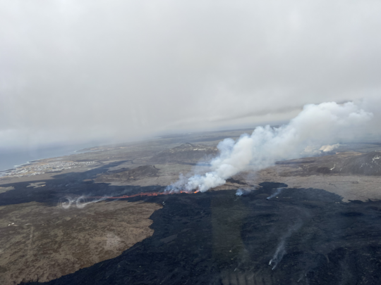
Was surprising to see it pretty much unchanged from yesterday afternoon. Maybe this will last longer than 72 hours, and in that case possibly enter the sea, which should be fun to watch.
The hesitating eruption indicated that something would change. We currently witness the first Grindavik eruption that can indeed focus on a central lava vent. The vent is still a short fissure of (?) 100m (?) if I estimate it correctly:
https://www.youtube.com/watch?v=8bfcTBLvPiM
The 4th Grindavik eruption does, what Fagradalsfjall did on the second day of its eruption: The shift from fissure eruption to a central vent. Video of 20th March 2021 (2nd day of Fagra I):
Thorbjörn Webcam has a good view:
Once the weather clears…
The weather likely causes some steam clouds above the lava fountains and field. Weather forecast for Grindavik shows that we get a rainy day today:
I am extremely tired of doing research for my articles, coming across an interesting study that definitely has some crucial information but being unable to access it because it’s behind a paywall Some studies that were released 30-40 years ago are still cost 30 dollars to access which in my opinion is just ridiculous.
There is good money for scientific publishers. Not only do you gave paywalls, but researchers generally have to pay to have their work published.
*cough* // site removed // *cough*
Apologies, I shouldn’t have posted that due to it affecting the people who dedicate their time on the blog.
send an email to volcanocafe with details of which paper. We will see whether we can access it for you. No promises but it may work
Hi Tallis,
If you put the details out here in the open, I can take a peek if our library has it in its system. Our geology department keeps a fairly good portfolio of subscriptions and provides access to others through interlibrary access.
Thanks!
https://linkinghub.elsevier.com/retrieve/pii/S0377027319301684
Currently trying to find out how much magma has accumulated at shallow depths.
Hi Tallis,
That was straightforward as I was able to download that paper without any problems.
Now, how do I get it into your hands? I could send it to VolcanoCafe and hope that one of the dragons forwards it to you.
Holger – yes, that’s fine, although I was able to download it myself so I can always send it to Tallis as I already have his email address.
Hi Beardy Gaz,
No problem. Feel free to e-mail the article from your end.
Thank you for your help everyone.
Taliis, I agree with you. While trying to do my number theory research (and I am on the cutting edge) these websites want to soak me for $60 to $129 for just a single pdf paper. What I do is privately email the mathematician, and he/she sends me the paper for free. (example: back issue articles Mathematical Gazette)
The fee is not meant to be paid! It is meant to block you from reading it, so you bug the university library to subscribe. If people start to pay, the publishers will raise the fees until they stop.
This is the only theory that I have ever heard about the ridiculous per-article fees that makes any sense. Fortunately I have access to most of the big publishers through my University so don’t have to deal with that nonsense. And for those rare occasions where they don’t, I can usually find another means of accessing (like from the author’s website).
My policy is that if the paper is not accessible to me either from the publisher or from arxiv, then I will assume the author had a reason to not want me to read it so I won’t cite it.
The Lava Wall was successfull, lava invaded the Wall Street 12 days before 1st April could produce a news title of this.
What if next lava flows takes the same way? The wall can bear one lava flow or two, but then it’s Game Over. It’s possible that the site of the current site erupts several times and that lava flows take the same directions again.
Increase the hight of the berm (where there is a risk) before the next event. It will take a lot of soil (old lava remains).
Does anyone know if the lava has reached the road yet? Down south of course not the one that was crossed 5 hours after eruption.
One thing I missed both during Fagradalsfjall’s eruptions and Svartsengi’s are Webcams on the lava front. We don’t know where and how the A’a lava is creeping now. It is nearly stopping, but would be interesting to see, also the interaction between lava and landscape.
What is the west flow doing? We’ve seen a lot of discussion about the Southern Coast lava flow, but there is a second western lava flow that cuts off the Blue Lagoon from Keflavik roads.
https://myndir.ruv.is/eyJidWNrZXQiOiAicnV2LXByb2QtcnV2aXMtcHVibGljIiwgImtleSI6ICJtZWRpYS9wdWJsaWMvb3JpZ2luYWxfaW1hZ2VzL3ZsY3NuYXAtMjAyNC0wMy0xNy0xMWgyNG0yMnMwNzUucG5nIiwgImVkaXRzIjogeyJyZXNpemUiOiB7IndpZHRoIjogIjgwMCIsICJmaXQiOiAiY292ZXIifX19
If the flow is being fed continuously then the a’a front might stall but get overtaken by pahoehoe breakouts, or such breakouts could just flow out of the a’a flow front. That happened a lot at Kilauea when the lava would descend down the south flank pali and turn to a’a, only for the flow front to stagnate and pahoehoe to break out of it. HVO actually only uses the names to describe the solid rock, as active flows can actually convert between them.
In this case the a’a was from high eruption rate not steep terrain but the effect is pretty much the same.
The Grindavik eruptions have to deal with flat landscape. The lava fissures happen around 100m above sea level. If I assume a distance of 4km to the sea, the average descent is 2.5%. This makes lava flows slow and doing a’a, although the lava is hot and fluid.
Even Shield volcanoes, that have flat slopes compared to Strato volcanoes, are steep compared to Grindavik’s landscape.
The risk of Pahoehoe breakouts means a risk for the lava dam. While at present it protects Grindavik, a possible Pahoehoe breakout can be a threat for the stability of the dam. If it’s overrun by lava, the dam can easily break and cause a lava flood.
Fully agree. We’re blessed with so much footage of the events happening in recent time…but…please show us how the lava front is developing instead of endless spattering at the heart of the eruption.
It might nit be shown because it is no longer expanding?
Not easy to see anything at all, it is only fog and rain.
Maybe it is not expanding now…well, let me put it this way, I have not seen proper aerial footage of how it looks like at both lava tongues, only dim, hazy extreme panned webcam shots. I’m not a scientist, just an enthusiastic follower of volcanism and am just curious how it all develops. So to all drone pilots on site; please also show the front ends.
But Albert, it is extremely addictive to people who love watching paint dry!
I’m pretty sure it hasn’t yet, Icelandic version of RUV mentions how slow the lava is moving at the moment, but there is a big lava pond that might break at any time and then it would go straight to the sea, through the road. Unfortunately it’s too foggy to see anything with the webcams at the moment. Hopefully we get some drone footage soon.
How would we notice during night and fog, that the lava dam has failed and lava floods the port of Grindavik? Maybe they should place a submarine there to monitor the eruption …
But I’d assume that the low rate of the eruption reduces the risk for an escalation of the situation. Maybe the next eruptions (April, May, …) at the same place are a larger threat, mainly with the high lava output rate during the first hours of the eruption.
Many thanks to everyone who answered my question earlier about the lava and southern road.very much appreciated as I was out all day. Looking at it now on Þorbjörn cam it is hard to see where it has reached now but it does look much further south than I saw it last night. I guess we will only see if it is still moving at all once it is dark, but then we wont see the road, if or when it tries to cross the road though we should then see the dark smoke and flames as the tarmac burns. Of course by then it will either be a massive snowstorm of fog and blinding rain. Ah the joys of volcano watching in Iceland. 🙂
Yesterday, IMO estimated 12 hours if movement continued at the same rate. However, today they said it has slowed and has changed little since yesterday evening and this morning it was still 330 metres from the road. They’ve also published a map of the lavafield.
https://en.vedur.is/about-imo/news/volcanic-unrest-grindavik
Sorry, 20 hours, nit 12.
The eruption fissure is now located on Dalahraun. That’s likely the core part of the Thorbjörn subsystem. Most eruptions are likely going to happen there again and again in future. Only side vents will happen outside this area (but they can cause problems).
Bardarbunga continues with earthquakes, one of them with sensible strength for humans (above 2.0)
Are they related to Grimsvötn?
I answered someone this morning on this (see further up) – Not directly related to Grimsvotn, more to do with the magma input below. It’s just Bardy recharging its magma chamber at the base of the ‘plug’.
Oh yes, that’s a possibility. Maybe Bardarbunga also supplies a tephra show in future. That’s the most common eruption style of the volcano. Holohraun was an exception. Otherwise the majority of Bardarbunga’s eruption is like Grimsvötn common ashy eruptions. But with lower frequency.
I think there is a fairly logical reason why the eruption is going on still, and *might* continue;
As I’ve commented before there has been incidents of heavier smoking leading up to March 2. and also up to this eruption. Based on IMO stating that apx. 1,3 mill. m3 of magma went from the sill to the dike at the March 2. incident, that should lead us to believe that the dike was amost pre-filled at the time of the eruption on last saturday. I find this bit of timelapse from the afternoon of friday 15. N of Grindavik very interresting in that regard. Watch the timelapse from apx. 1 min. 45 sec. and bear in mind that it rained heavily before you see what you see.
https://livefromiceland.is/timelapses/fagradalsfjall/2024/03/15/
The level of heat (=magma close to surface) present is quite clear. The exact same can be seen at the same time (there was an opening in the weather) at the Langihryggur cam where the steam is even more prominent. Watch from apx. 47 sec to 53 sec mark in the timelapse from the day before this eruption.
https://livefromiceland.is/timelapses/langihryggur/2024/03/15/
All this indicates to me that this time the intrusion from the sill to the dike did not have to a) fill the dike and b) try to erupt, because the dike was already prefilled pre eruption. Meaning the sill was not drained enough to cut feed to the dike. After the intitial pressure driven Ketchup-effect from starting to erupt it is not impossible that an equilbrium was established leading to a new normal where the eruption can be sustained at feed rate. Or at least that the ketchup-effect will be quite a bit longer lasting. Because there is no longer a gap in magma feed from the sill to the dike. Remember; we have observations to tell us exessive smoke preceded both the failed eruption on March 2. and the sucessful eruption this saturday. Indicating magma present in the dike. And probably lots of it based on IMO’s post March 2. calculations. So that the two weeks post that simply filled the lacking magma in the sill, topped up the dike and created conditions for a lasting sill -> dike -> above ground feed. We have observed a ~12 cm drop in ground levels like in the past, but if the connection sill/dike is maintained still, the idea of a pre-filled dike could explain why the feed is not “cut off” this time.
I think we need longer time-series of GPS data to ascertain if uplift slows in this scenario.
Any thoughts?
Yes, I think we’ve got two eruptions in one. The intrusion of March 2nd erupts together with the intrusion of March 16th. This would make nearly double volume. Added to this the eruption style shifts toward a “longterm” behaviour with lower rate. The output rate has reduced to 5-10% of the first hours of the eruption. It needs more time to get the whole volume out. The eruption has built up to keep lava going for more time than the first three eruptions.
To compare it with Pu’u O’o Fires: First spectacular discrete fissure eruptions; later slight shift towards gentle, steady lava eruptions from circular vents. It’s possible that once there will be lava tubes from Sundhnukur until the ocean … like Pu’u O’o did during the “adult” age of its eruption.
ADAV:
I agree with you. Things definitely have changed and we might be seeing these small cones continue for the next few weeks, IMO.
Húsafell webcam shows slowly progressing A’a lava flow now (towards Husafell). Húsafell is the first mountain in the east of Grindavik:
It seems that over more than 12 hours since 6pm last night, the southern front only moved something like 20m. So where is all the lava going? Ponds were mentioned but I’ve never thought of volcanoes as being fans of landscape gardening.
I am no expert, but ponds is i think the right answer to your question.
Looking at the Fagra-eruption this is what happend. First the fissure flooded the area, then a couple (or single) cone became dominant. The lava-tongues are fed from here.
Due to declining supply rate (compared to the first part of the eruption) and the long distance of the lava-tonque is believe the lava slowes down. Like a dam in a river, the cooled outside crust of the lava-tonque holds the lava. The lava, unable to advance outwards build ponds, untill the pond overflows or breaks the dam. Only difference with a river is lava is both water and dam at same time 😉
If you have watch de Fagra-streams, you could see this happening. Lake-forming, outbreaks, pond-draining. (Thanks volcano-gods for giving us a cute baby-volcano, so we could see this proces in detail).
The area is fairly flat and if there is already part solidified magma there it is just going to sit on top, AKA ponding (how ponds are created by rainfall falling on a road for instance).
Instead of spreading evenly everywhere, you’re going to have sections where it’s a few metres thick or more, and while the fresher stuff may be sitting on top of the more solidified stuff, it could eventually slide off or burst through.
The Húsafell (House Mountain) webcam shows how the fluid lava is standing on the lava field. It looks like some phases of Fagradalsfjall’s 2021 eruption when Geldingadalir was filled up and lava was stored all around the central vent.
The eruption is slowly concentrating towards a central cone. It will be interesting to see how large and tall it will become and how long it’s going to erupt. It’s possible that we currently see the central volcano of the system erupting. It may play the role of Bardarbunga’s or Kilauea’s caldera with the majority of eruptions during the Fires period and the source of intrusions into the fissure system NE and SW from the central volcano.
If we apply the classification of eruptions of the big Icelandic volcanoes on this small one, we can classify:
– The January eruption was an eruption in the fissure system
– All other three eruptions have happened on the central volcano (Sundhnukur)
There is an IMO frettir page update.
https://en.vedur.is/about-imo/news/volcanic-unrest-grindavik
Orange 1.55 utc 17 march
Red 14.56 utc 17 march
Since the image posted is rather small, here is the original link: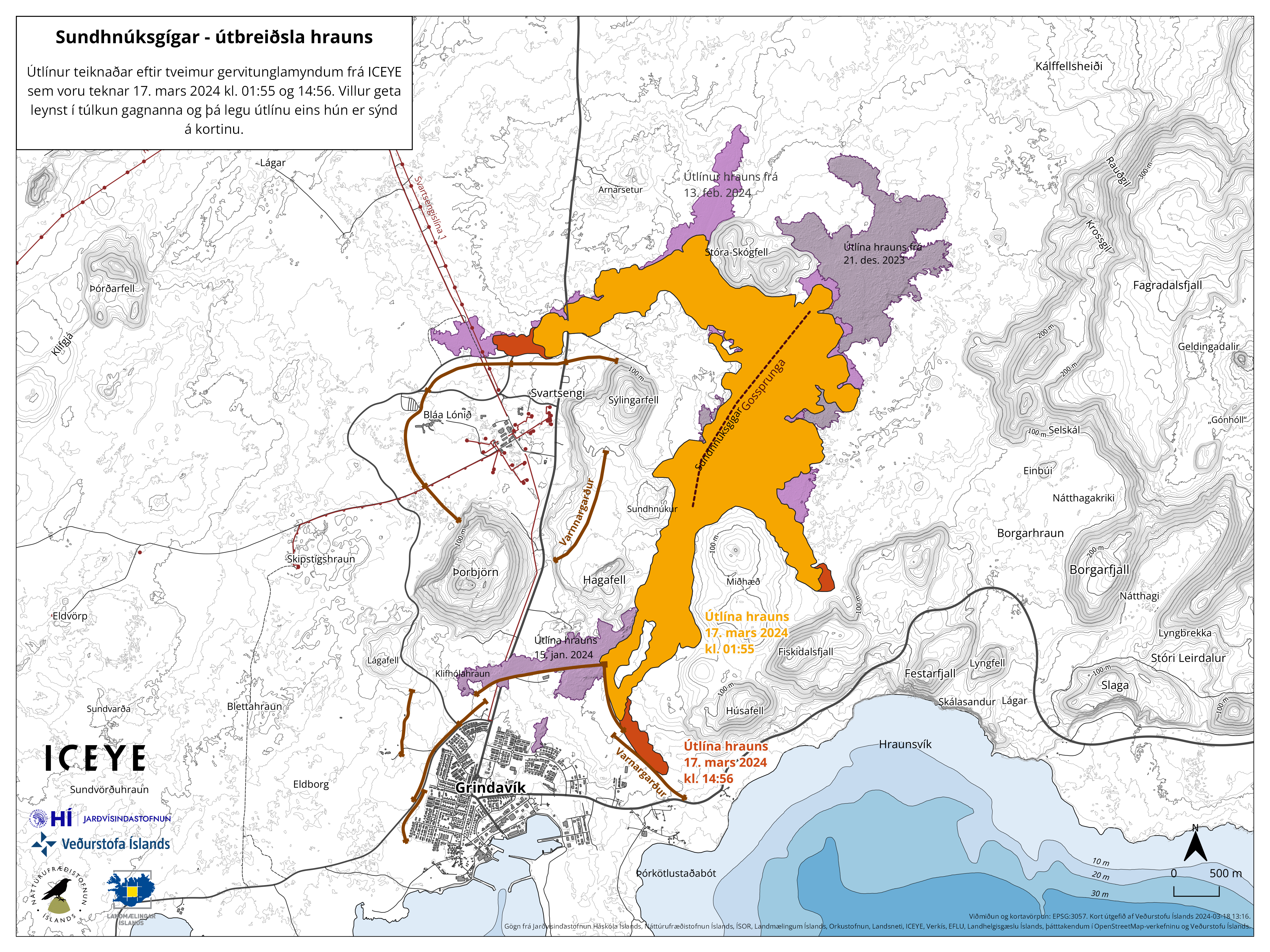
So there is a so-far-unseen tongue heading towards Fiskidalsfjall. If lava was/is able to reach that cliff, it could reach the road.
I think that is a cliff *up*, not a cliff down? Looks like a dead end absent considerable pooling there.
There is a dead-end street, because Fiskidalsfjall is a mountain like every real “fjall”/”fell” in Iceland. But if the eruption continues, the central location may rise a bit and get a higher/thicker lava field. All sides of the lava field are able to expand. The whole plain between Thorbjörn hill and the Fagradalfjall plateau can get lava coverage.
If you want to get a new challenge with Icelandic names: “Hellisheiðarvirkjun” has had an earthquake swarm which has got more shallow to 3 km depth. That’s close to Bláfell and belongs to Brennisteinsfjöll. In the past Reykjanes Fires often began there and moved west along RVZ. Do they have deformation monitoring there?
Yes, the IMO is monitoring deformation in the whole western side of the Reykjanes Peninsula
The only exit towards the Southern Coast Road and the Atlantic Ocean is the area around Grindavik. Towards the east lava would be caught in a saddle between Svartsengi’s lavas (Dalahraun) and Fagradalsfjall’s lavas (Borgarhraun).
The Sundhnukur area is likely going to rise a bit. It is the top of a flat, broad lava shield, that’s caught between the Ice Age subglacial cones of Thorbjörn, Husafell, Syglingarfell etc. With the present Fires this lava shield is going to rise a few 10m over next 30 years and to distribute lava all around.
With GPS station SENG and a few others apparently reinflating rather deflating at this instant, it seems to indicate a long eruption this time ?
The supply is certainly high enough to sustain a long-lived eruption.
That said, Kilauea erupted 3 times in 2023 and always died out rapidly despite the supply being strong enough to keep an eruption. The reason I think is that magma was directed towards the expanding magma deep rift rather than the surface. So I’m not saying it won’t happen, but the supply can go into inflating underground rather than erupting onto the surface. What will Sundhnukur/Svartsengi choose? I don’t know. But short-lived eruptions are prevalent in the Svartsengi area and the somewhat longer-lived ones, like Arnarsetur I think, were concurrent with deflation and with moderate eruption rates.
But is it really inflating though? It’s still only a few samples and if you look at the difference between SENG and RVIT, NYLA and HVAS, where common errors such as atmospheric disturbances and errors in satellite positions cancel out, those graphs look completely flat. Only SENG-KRIV has a small remaining increase.
I tend to use the SKSH/HS02 ones as they are probably the best ones to gauge the inflation of the sill. SENG is away from the centre of the inflation and may be showing recovery rather than inflation.
As you said, there’s only a few data points so it’s not clear enough to make a conclusion on the sill inflating even with the eruption continuing. If the output on the surface matches the inflow into the sill from the deep source, it won’t inflate.
I think we can see it slowly waning in strength already but it could last the week. The sill itself is relatively small in terms of magma chambers, and would require a very high level of supply to keep it at a high enough level to keep the Duke pressurized.
Dukes of volcanic hazard?
The simple pleasures of Daffy Dike
Drone flight coming up (battery change right now)
Iceland certainly do photogenic eruptions.
Especially the first one! I was stuck to my computer monitor for about 6 months.
Does anyone know what the actual rate of eruption is now? There are still a lot of vents but there isnt a very defined channel to give an obvious indicator. With that many vents still I would expect it to be relatively high but then who knows.
If it sustains this way though then we should expect an ocean entry. A’a flows can sometimes be reactivated when they appear dead if the flow is only recently stalled. And the other option is that the lava is simply building up in a big pond near the vents and will eventually break out and reach the ocean that way.
They estimate 20 cubic meters per second and the new flows are moving on top of the old one.
https://www.ruv.is/frettir/innlent/2024-03-18-enn-stodug-virkni-i-eldgosinu-407701
You can see the new flows moving on this stream: https://www.ruv.is/frettir/innlent/2024-03-18-enn-stodug-virkni-i-eldgosinu-407701
Seems one of my points is confirmed:
“A lava pond that could burst in the direction of Suðurstrandarveði
Craters formed as a result of the Sundhnúks crater series continue to spew lava. Although the lava flow is slow, experts from the public defense have identified a lava pond at the end of the lava rim at Suðurstrandarveg.
If its rim breaks, the lava can flow forward with great speed. Then it would be quick to reach the road, and people who might be in the road would hardly have time to escape.
There will be no flights over the fire stations today. Visibility is low and drones used by civil defense have been put to good use to assess the course of the eruption.”
Similar lava ponds at Kilauea in 2007-08 and late 90s early 2000s could burst and send fast a’a flows as much as 6 km in a matter of a day or so. I think even a few managed to reach the coastal plain within a few hours after flowing from within 2 km of Pu’u O’o. The lava flows of Arnarseturshraun flowed similar distances too.
So really unless the eruption stops now it is nearly inevitable. But then, this eruption has already kept going through all of the points that its predecessors had stopped at, and seems largely unchanged for the past days, so its a bit uncharted now really.
That’s still higher than the typical Fagradalsfjall output rate. The 2021 Fagradalsfjall eruption showed that an eruption can last long with a low output rate.
With continued lava production, if crustal deformation (upward) continues in the Svartsengi group, but at a lessened mm/day, that will um… be interesting. I was going to say it will tell us something, but it seems like the volcanoes in this area never tell us anything for very long. I once said these are weird volcanoes, which some here said was incorrect. It was incorrect. These volcanoes aren’t weird. They just have inconsistent messaging.
Maybe they are not volcanoes.. they are rifts. The first dike formation involved a wide opening of the rift through Grindavik, as the western part of the peninsula moved west and rotated a bit. The sill had started formed well before that, of course. But ever since, the magma has escaped through this opening whenever the pressure in the sill became sufficient to lift the rock layer that acts as a barrier between it and the rift. Seeing the rift as an ‘opening’ is not quite right: it is a low-stress weakness which the magma can push apart. If the rifting hadn’t happened, then the sill would have continued to fill up until something else gave way, followed by a much longer-lasting eruption. Now we have the intermittent eruption corresponding to a pressure valve failing each time. The current eruption is a bit more vigorous than before – as has been suggested, this may be because the rift was already partly filled by the previous diking event. In that case we may have another few days before it closes down. The sequence may only end when the conduit that fills the sill itself closes. When that happens, it will be quite sudden, I expect, and without much warning. Speculation alert!
This is how I envision it, with each section having it’s own ‘rift to be filled up with magma’, potentially. Eldvorp could have happened (and still might!) had the pathway not been created.
One question I have would be are all of the temporary magma chambers on the peninsula stored in the North American Plate? The quake swarms seem to be predominantly westward of the previous eruption vents.
The pathways to the surface seem to be on the North American side even though the earthquakes extend to the European side. That was quite clear in first Fagradalsfjall eruptoipn where the cones approached the boundary but did not dare cross it. It also seems to be the case for the old eruptions. But the mini eruption that managed to sneak into Grindavik did erupt on the other side. Note that there isn’t a sharp fault line here, at least not one visible on the surface. My suspicion is that the oceanic crust on both sides of the divide has different ages.
The location of the currently erupting cone can become the “central volcano” on the Svartsengi-Grindavik rift. The channel from the sill / magma chamber is opened by the magmatic heat and should allow the quick rise of new magma whenever the pressure is high enough to overcome the force of gravity.
The Hagafell cam is presently showing a beautiful deep purple. Pretty amazing.
Does anyone know what the numbers on the y-axis are as shown in the unrest charts from vafri.is? For example this Svartsengi (SVR) chart :
I’ve no idea, but my guess as a DSP nerd is that the y-axis correlates with power or intensity. Essentially energy over time. A physicist might say rate of energy transfer or radiant flux. The actual numbers may not even correspond to something real/calibrated. It’s all relative anyways.
You can do this by computing the squared magnitude of a particular bin corresponding to the frequency of interest, from a short-time Fourier transform computed over some defined time period T, ie. t0 .. t0 + T, t1 .. t1 + T, t2 … t2 + T. Etc. This is all applied to some kind of raw time series data coming from a physical sensor.
Wikipedia has a good article on spectrograms: https://en.wikipedia.org/wiki/Spectrogram
These plots are not spectrograms. They show the amplitude of the seismometer data after applying band pass filters for three different frequency bands. As I have understood it, the plot uses a short observation interval (seconds or maybe a couple of minutes) where the maximum amplitude during each interval is recorded, then there’s a reporting interval where the maximum and minimum observations during this interval are plotted as a single vertical line. This interval seems to be every 15 minutes. I’m not sure about the unit used for the amplitude, if it’s linear, quadratic, or logarithmic, but I do know that it’s never rescaled.
The way the plot is generated means that for continuous volcanic tremor, with a constantly high amplitude, the lines will be thin around a high value. For a quake swarm on the other hand, each reporting interval will have observation intervals with both low and high values. This gives the plot a thick, fuzzy appearance. Wind and wave noise can also elevate the levels above normal background levels. Then we have special cases like the episodic activity during 2021. When the eruption interval was smaller than 15 minutes, the line was very thick, showing both full eruption and background levels in the same plot. When the interval was longer you got alternating levels in the plot.
These plots are probably the single largest cause of confusion for us amateurs watching from the side line.
No, they’re not spectrograms. Spectrograms cover a wide band, each represented by a line, where the color/intensity follows the amplitude. Spectrograms are computed using STFT, like I described above.
I’d just like to add that, under certain circumstances taking a single bin from an STFT and smoothing over time is essentially the same as doing a narrow bandpass filter of a time series. Raw magnitude is correlated with energy or displacement, and squared magnitude is correlated to power or intensity. If you use a log scale, the “unit” will be something like dB, and then it doesn’t matter if you square the magnitude or not. That’s just going to be a factor of 2, which will “disappear” when you normalize the data before plotting.
I think these plots use a linear scale, but that’s just another guess.
It’s interesting to me that they never rescale.
*Each FREQUENCY represented by a single line.
For a few hours, one of the Mt Þorbjörn cameras has been zoomed in on the southernmost lava flow. It appears that the lava has overtopped the berm and, instead of being channeled towards the Southeast, is heading in a more southerly direction, albeit very slowly. It is difficult to make out because of the cloud but, if you scroll the cam back to around 8.13 this morning (19/03/2024), you’ll see something has caught fire at the tip of the lava flow
For a few hours, one of the Mt Þorbjörn cameras has been zoomed in on the southernmost lava flow. It appears that the lava has overtopped the berm and, instead of being channeled towards the Southeast, is heading in a more southerly direction, albeit very slowly. It is difficult to make out because of the cloud but, if you scroll the cam back to around 8.13 this morning (19/03/2024), you’ll see something has caught fire at the tip of the lava flow
I think the lava you are referring to might be the lava from January not the active flow. But it does seem like a new front is advancing towards that same area anyway just not to the barrier yet. I guess ut is better than a flash flood of lava when the pond breaks but the first flow filled up behind the wall to quite a depth so it is now very questionable if the walls could resist another flow. Its also possible the new flow front could bury into the interior of the first flow and reactivate it essentially turning the whole flow field into one slowly growing thing, which is what happened at Holuhraun and Kilauea a lot.
I think I was mistaken, right enough. Through the murk, I now think that what I perceived as a Westward bulge in the lava is, in fact the lava “backfilling” the space to the East of the Northern end of the Southernmost berm. (All points of the compass in one sentence!)
Dear dragons, sorry about the duplicate posts. It seems I forgot my own name!
I was musing over volcanic activity in the Reykjanes peninsula in the bathroom this morning, as one does.
This is no doubt well researched. But the Fagradalir eruption took place in uplands, while the current eruption is taking place in lowland rifts. (Captain State-the-Obvious has nothing on me!)
As activity continues, the shape of the land shows what kind of magma and acitvity we’re likely to see. Uplands will be ridge, cone and hill building, and probably longer lived eruptions. Lowlands will be cone-rows, effusive and short-lived outpourings.
Well. There we have it. The future of the current uptick in Reykjanes volcanic activity all mapped for you. Sadly and as usual, I am probably the last to come up with this understanding.
The first two Fagradalsfjall eruptions happened in the southern end of the Fagradalsfjall system. There they had to deal with fragmented landscape created during the Ice Age. All the hills/mountains that surround Geldingadalir and Meldalir, were created by subglacial eruptions (comparable to Grimsvötn’s eruptions). The ice/water coverage supported the construction of higher volcanic cones than the 2021-2022 ice free eruptions.
The third Fagradalsfjall eruption 2023 happened in more open landscape comparable to Grindavik, but it happened on higher altitude than Sundhnukur: Sundhnukur “central volcano” is ~100m above sea level, while Fagradalsfjall’s shield peak (Þráinsskjöldur) is ~238m above sea level. So all creeks and lava flows on Fagradalsfjall’s shield have a bit more steeper slopes than Sundhnukur. There is more physical energy involved in the relation to sea level.
The general trend of the physical geogrpahy on Reykjanes Peninsula from east to west is negative. Brennisteinsfjöll’s peak has 600m, Krysuvik 300-400m, Fagradalsfjall 238m, Svartsengi 100m, Reykjanestá around 0m.
Grindavik has been reopened for people living and working there, since there’s currently no risk of lava running into the town. It is recommended to keep track of gas pollution reports and it’s not advised to stay over night.
https://www.ruv.is/frettir/innlent/2024-03-19-grindvikingar-mega-dvelja-og-starfa-i-baenum-407821
The force of the eruption hasn’t decreased significantly and magma continues to flow into the system, to support the ongoing eruption.
https://www.ruv.is/frettir/innlent/2024-03-19-visbendingar-um-ad-ekki-dragi-ur-krafti-gossins-407821
The last two days the eruption was stable and the intensity hasn’t decreased.
https://www.facebook.com/share/p/mdbWpLwba8e3RJDp/?mibextid=xfxF2i
A picture of where the active flow front was at 8 pm 18 March, about 17.5 hours ago now. So presumably it has moved further but not necessarily following the first flow.
The past 8 hours, the vigor of the row of 10-11 vents on the south end of the fissure lineament has noticeably decreased https://livefromiceland.is/webcams/thorbjorn2.
The patch of lava in the background of the 3-4 vents on the right hand side, behind them has noticeably increased in emission of smoke. It however seems to be higher in elevation than the vents in front of it. Does anyone have an idea of what might be happening here? More white smoke is drifting into the field of view from the right hand side too. https://livefromiceland.is/webcams/thorbjorn2
Is there any camera showing the lava pond to the right of this camera view?
Looks like burning peat.
You are probably right, which might indicate that the lava pond level is rising still.
I don’t see any reduction at all… Keep in mind that at some point during the day, the camera zoomed out so that you can see some more of the lava river heading off to the right. So, if you didn’t notice that change in zoom, it could look like the output has decreased. But taking that into account, it looks about the same to me.
EDIT: I didn’t look at the time stamp of your post closely, which shows that you posted *before* the zoom-out in question. Nevertheless, I still don’t see any obvious decline in vigor of the fountains.
Dan, I watched off and on for about 8 hours last night and this morning. There was a decrease in vigor or the spouting from the vents during that period. The past 6 hours or so has only been a slight decrease in activity. I am aware of the change of the view in the scope of the camera. Again, we need software (perhaps using AI) to auto-scope each fissure vent, and keep track of the activity so as to be able to do an accurate trend analysis. This is not an easy task, due to changing light conditions, day/night, etc and weather conditions also. But I believe it is doable.
Fair enough. I was not scrutinizing it as closely.
From about 3 pm my time to now at 8 pm.. the past 5 hours, there has been little if not any change in the fissure vent activity.
Iwo Jima with boiling water: https://www1.kaiho.mlit.go.jp/kaiikiDB/video/iou/20240316.mp4
Something between aggressive Fumaroles and a viscous Surtseyan eruption. I’ve found the link in a Facebook group.
https://www1-kaiho-mlit-go-jp.translate.goog/kaiikiDB/kaiyo22-2.htm?_x_tr_sl=auto&_x_tr_tl=en&_x_tr_hl=en&_x_tr_pto=wapp#photograph has more pictures
Cerro Negro is looking like it’s about to produce another major swarm, and now Iojima is steaming too? Might have to write and update over next couple of months
Can you link the cerro negro report in question?
https://www2.sgc.gov.co/Noticias/boletinesDocumentos/Boletin_volcanes_sur_feb_2024.pdf
https://www2.sgc.gov.co/Noticias/boletinesDocumentos/Boletin_volcanes_sur_ene_2024.pdf
The last 3 seismic swarms were both preceded by a cluster of VLPs quakes. I’ve been looking at the regional Seismogram TULM and a noticeable uptick in VT quakes has been noted in the past week. These conditions remind me of the beginning of the 2022 seismic crisis. Of course this just my hypothesis
https://icelandmonitor.mbl.is/news/news/2024/03/19/disagrees_with_the_icelandic_met_office_about_the_e/
Þorvaldur Þórðarson seems to disagree with the MET office’s conclusion about the latest eruption…
https://www.ruv.is/frettir/innlent/2024-03-19-kvikan-virdist-ur-sama-kvikugeymi-og-i-sidustu-gosum-407821
“The chemical composition of the lava smells similar to the last eruptions”
I imagine a group of scientists taking a sniff. Lava sommeliers at work. Commenting the odeur in pompous language in a french accent. 😀
It is erupting French cheese? It might taste better than it smells.
(This is NOT a request.)
When I studied chemistry, one of the optional courses I took was geology. During the mineralogy/crystallography practical class the lecturer informed us that one informal identifying test is to taste the mineral sample by licking it! We were advised that discretion should be used when applying this test, especially if the mineral was green in colour……..
There is ground observation confirmation of an active lava lake at Tofua. It erupts the same low crystal basaltic andesite as Hunga Tonga Hunga Ha’apai and is a similar caldera just higher above sea level. In most cases a lava lake would indicate an open vent and it does in a way but low crystal magma tends to indicate there is a lot of it accumulated to let the crystals settle. Large volume of fluid magma at a caldera known to have big eruptions is not a great idea to live on I expect, and being frequently active didnt mean much in 2022. Still not that likely to follow its neighbor immediately but its interesting.
https://www.facebook.com/share/r/XgUsXZPCAHTHJi8b/?mibextid=0VwfS7
Chad:
I agree. The NASA FIRMS (Lance) satellite keeps picking up this lava lake and it’s been going for at least 2 years. There was an expedition to the island to check up on this (which unfortunately the internet search engines cannot seem to locate) and they found that the activity was more than the satellites had picked up.
This volcano needs close watching. See https://volcano.si.edu/showreport.cfm?doi=10.5479/si.GVP.BGVN202302-243060
There was a TV documentary on recently about the HTHH event. It briefly mentioned Tofua at the end, including that it had an active lava lake.
Can that really be called a lava lake? it’s just a small incandescent spot.
How about lava pond? 😉
Héctor:
I just found this link https://tropicalislands.net/tofua-island/ which has interesting photographs and some narrative.
The question “when did this caldera collapse occur?” is an important one to answer. I hope some future volcanologist can provide an answer.
1000 years ago. A mafic basaltic-andesite ignimbrite eruption. It was roughly contemporaneous with the previous caldera collapse of neighbouring and similar Hunga Tonga volcano.
https://link.springer.com/article/10.1007/s00445-011-0477-9
Thank you for the reply and paper. 1030 AD sulfur spike in the ice cores shows the eruption.
MAY show the eruption. That link is far from conclusive
I would agree, but then by that definition only Erta Ale and maybe Nyamuragira have a lava lake and the rest are just ponds
I need to have read this post with scrutiny, but at the time, I couldn’t get onto facebook. The PBS documentary here IS the one which I referred to in my first post to Chad’s remarks about Tofua Volcano.
The lava field and fluid lava stored on it are slowly but significantly rising:
https://www.youtube.com/watch?v=8bfcTBLvPiM
During Fagra I in Geldingadalir we observed a similar development: The lava level rose over time and drained some erupting craters. After this the eruption changed and concentrated on the central vent.
The Dalahraun shield has a lot of space for lava to fill until the lava level can drain the erupting cones. If the magma force is strong enough, the cone can grow with the lava field. Otherwise the eruption will end, when the lava drains it … or if the magma support decreases.
Can the eruption last until the next “episode” after 20 days? Maybe we now get a low level enduring eruption, that after a period of 15-20 days gets a new flash of lava.
I think I’m seeing the inflation in the Svartsengi group continue, but at a reduced mm/day. Doesn’t this indicate a pretty direct connection between the magma inflating Svartsengi and lava production to its East? In that case we might see a more gradual increase in lava production to the point where inflation stabilizes at Svartsengi. Gradual instead of the surges.
My guess here is that whatever structure was causing the cyclic nature of these eruptions has been broken or blown through. Kind of a pressure relief valve where the spring gave up and the plug will no longer seat. It can still regulate flow but now only as a orifice.
Looking at the GPS data. Last year’s eruption didn’t affect the rate of inflation at all. That is absolutely insane because it means the amount of magma that was erupting was insignificant or borderline irrelevant to the amount of magma entering the system! The amount of pressure that was released in the eruption couldn’t slow down the ongoing pressurization of the system. Insane situation we have here…
This is Ioto? That would be pretty consistent with a larger caldera that is refilling, Earlier I liked to some into on Tofua which is a similar caldera that now has an open vent and a lava lake. Yasur is much the same but more developed in that way. It appears that actually having open vents is not necessarily important in determining if a caldera volcano is potentially capable of much more, filling magma chambers will need to empty one way or another and whether the crack is due to volatile expansion pressure or to gravity pushing the roof down the result ends up being the same once the collapse actually begins. Ioto is different in that its magma is more viscous while Tofua and Yasur are fluid but it seems otherwise very similar for the last year or so.
I guess it is good, it means the magma chamber isnt going to literally blow up from the pressure and there could still be a lot more time.
Somehow I completely forgot to clarify which volcano I was talking about…
I doubt there is a lot of time left for the volcano. Albert and I think a ring fault has developed at the volcano(Albert came up with the idea first). Looking back at the deformation records, 1977-1995 showed an area of deflation at the center of the Island surrounded by a ring of uplift. During and after this event phreatic eruptions have increased in the locations surrounding the island. The volcano has been escalating activity consistently so far and it is not likely to stop anytime soon
I think you can in a reasonable sense potentially describe what is going as literally blowing up from the pressure. If you have a large island being forced up at 1 meter/year as eruptions escalate…
One thing to keep in mind is that the dimensions in km^2 of the area enclosed by the seeming ring fault is roughly 2X the size of Hunga Tonga’s resulting hole. And if it is a highly explosive one, that may be more of a floor than a ceiling. High-end the larger suspected caldera is something like 5X the size of Hunga Tonga…Which would be extremely suboptimal for lowland East Asia. Shanghai particularly is one of the world’s largest cities and almost totally <5 meters above sea level.
The other thing to remember is big bangs often start with an escalation spiral months or years predating the big bang. Often with one fairly large explosion first. In Hunga Tonga’s case, one that may have been a high-end VEI 4 in its own right. With a system Iwo Jima’s size, not impossible a VEI 5 is merely a heads-up the grand finale is about to start.
Both Brenninsteinfjoll and Hengill/Hromantidur are having a lot of concentrated swarms of late.
Both also had an earthquake swarm in 2012
I don’t think anything will happen there at the moment while Svartsengi is active but maybe in a year or two
The particular swarm next to Hengill is apparently related to geothermal power generation at Hellishieldi but to be honest it seems very deep for that. IMO has said before that the quakes at Brennisteinsfjoll are it waking up so presumably they see other signs too.
Brennisteinsfjoll seems to erupt the same way as Fagradalsfjall with slow to moderate eruption rates, only the volumes are larger. Brennisteinsfjoll as a system is probably the most voluminous of the Reykjanes systems at least in terms of extruded lava, so while it wont risk flooding Reykjavik the same way Grindavik has had lucky escapes the eruptions are going to be large and probably equally extensive over time. Think multiple years of eruption at the rate on the livestream now.
Hengill is basically a mini Bardarbunga, its a rift volcano that does massive lava flood eruptions, like Sundhnjukur but 10x bigger volume. Apparently Carl said it can do eruptions over 10 km3 but that might be because GVP includes Skjaldbreidur which is probably incorrect. But either way there is probably going to be an obvious and lengthy charging period before rifting to build the required pressure. Maybe that is why it didnt erupt in 1789, no shallow magma. The potentially scary thing is if the quakes at Hellishieldi are magmatic and we get sills growing that break open a new rift, it may erupt on the northwest side of the mountain, both destroying the power plant and sending a fast flow down into the Eliðavatn or even further. Thats all very unlikely especially any time soon but Hengill is a bit of a grey zone about how it behaves.
One question is what the more plume-influenced magma means. Does that mean we should expect this bout to be meaningfully more voluminous than the medieval one? Hopefully not, as a couple hundred years of this is going to be very suboptimal for a relatively densely populated part of Iceland. If so should we expect parts that tend to be less active to do more. Eg, Hengill…
We can’t exclude that eruptions are going to happen at Brennisteinsfjöll in near future. Eruptions there are more probable than at Hengill. If we look at the Holocene time span, Brennisteinsfjöll (has) had a higher frequency of eruptions than Hengill. Brennisteinsfjöll is more the rule, Hengill the exception.
But the increasing general activity on RVZ (Reykjanes Peninsula’s Volcanic Zone) can have side effects on neighbouring systems that are unpredictable now. It’s possible that we get eruptions next decades on locations where we’ve never had any since Viking settlement. F.e. some on WVZ and Snaesfellsnes volcanic system.
I would hazard a guess that tension would have to be released at nearby systems before others can activate and the rifts open up. The crust gets thicker the further inland you go so perhaps those systems can sustain longer eruptions and/or larger sills.
IMO has published this photo from today morning:
They report:
” Lava flows from the craters towards the south, on top of lava which flowed in the first days of the eruption.”
“The development of the eruption and deformation signals over the next few days will reveal whether an equilibrium will be reached between the magma inflow beneath Svartsengi and the lava flow on the surface in the Sundhnúkur crater row.”
Perfect pair of Karmann vortices on the left lower middle of the photo, which aviation people know about, not often seen.
They don’t normally travel up-wind!
Sharknado?
Saw this link in a YT channel chat: https://www.almannavarnir.is/eldgos/myndavelar/borgarfjall-nordur-nordaustur/
It’s a basic cam sat on top of the berm to the east of Grindavik. Currently not a lot to see as the front seems either stalled or very very slow moving but, should that change, this might provide an interesting view. The ‘Drive’ option runs through the static photos like a timelapse film and it looks like previous days’ photos will be available.
Thanks for that, I have been looking for images showing the current position of the front. Last night’s drone flight never got there due to high winds (and I hope he can recover it when the weather clears). at the time it looked like there was lava flowing on top of the older flows headed south but still quite a ways from reaching that southern edge.
Hopefully Isaak managed to recover his drone after last nights’ forced landing. Like most media streamers he seems to concentrate on the photogenic output of spluttering lava and adjacent lava streams. It would be useful to see the leading edge of the flow where it threatens the berms and road which would have a major impact on the local community.
Is the current erupting fissure north of Grindavik exactly the same fissure which erupted in last December and February?
Not precisely on the same crack but within meters so basically yes. The ends of the fissures are a little more disorganized and diverged but most of the length is very close and is basically on the original dike in November.
Chad, is the cones actually right in the center of the Nov 10th dike emplacement? Offhand I would say yes, but I am curious as if this came out exactly smack dab in the middle?
Is the eruption currently in the phase that was previously dormant between the first three eruptions? It’s possible that the system has enough magmatic pressure that it continues to erupt on low level until the next pulse of new magma comes. Can the eruption continue for 15-20 days and then get an escalation again?
Can volcanoes switch between gentle steady effusive activity (f.e. lava tubes) and descrete paroxysmal spectacular events (f.e. vigorous lava fountains) back and forth? Did Pu’u O’o 1983 do this? Maybe Pu’u O’o is a good model how an episodic eruption can shift from episodic fissure eruptions to eruptions on a central vent.
Episode 7: It began with “low-level extrusive activity” on August 10th, then on August 15th “tremor intensity increased rapidly” and 50m high lava fountains occured with rapidly moving lava flow.
Here is a view of the lava field about 18 hours ago, showing that it is not appearing to advance because it is active over a wide area. There does seem to be an actual channel forming now though which looks like it is mostly feeding the lobe advancing towards the southeast. If the cjannel becomes defined then this flow will probably speed up and reach the ocean in a few days.
https://www.facebook.com/share/p/g8CWyFWJwZPj6gZh/?mibextid=xfxF2i
The lava field is slowly expanding in all directions, but it happens a bit randomly, when, where and how much it expands.
I have a hunch it will rather climb over the berm (close to where the two segments connect at an angle) and crawl towards town. The lava has already stacked high, the speed of its advance is rather slow, and the top of the berm quite close.
I am surprised they haven’t started to build a secondary defensive berm closer to town yet.
A lovely 360° view from a drone over the lave field yesterday morning.
https://kuula.co/share/56lj7?logo=1&info=1&fs=1&zoom=1&autorotate=0.01&thumbs=1&alpha=0.60&fbclid=IwAR0ely3tcyHp9215D-mBsscGIRYSBOkWCsmNrAB1I_8NU0qZIdJ2cfwM1is
Helpfully labelled.
Oh hang on, that’s what Chad just posted above.
Great Mosaic View (RUV): https://www.youtube.com/watch?v=kXD4A9uFHcg
3 of 4 webcams show the erupting cones. Do I count correctly that there are 4 active cones?
The current phase of the eruption reminds to April 2021 at Fagradalsfjall with several active lava cones.
This is the 3D model of Fagradalsfjall on April 18th 2021. It shows the active volcanic cones at that moment. They remind to the current cones of Svartsengi: https://sketchfab.com/3d-models/geldingadalir-volcanic-eruption-18042021-439e33653b8142e3b7039d15c2d8bae2
This one is not blocked by the fumes
https://www.youtube.com/watch?v=rEMz0hwyfFs
There seems to be either 6 or 7 craters, depending on if the 2nd and 3rd are counted as separate.
It does also look like slowly the craters on the south end seem to be dying while the two larger cones at the uphill end are getting pretty big now. If this eruption does keep up for a while one of these two, or possibly a merger of the two, will probably evolve into a large cone with tall fountains.
It will be interesting to see how the resumed inflation affects the eruption later. If this vent is still open in a month or two and the GPS reaches the pre-eruption levels again will it just open the whole fissure as typical or will it erupt from the current vents. I have seen that the supply rate at Svartsengi is presently supposed to be between 5 and 10 m3/s but if there is inflation despite the eruption ongoing then the supply must be higher…
Given the persistence of the inflation I have to wonder if there isn’t some kind of valve mechanism involved…something that slows or prevents the final rise of magma to the surface.
I have no idea what this may be or how such a mechanism could form.
But as inflation has been pretty constant over several months, despite several eruptions starting AND THEN STOPPING, I wonder what made them stop ?
In particular, what made them stop for so long, when it seems distinctly possible that the feed from below and the outflow seem to be vaguely close to equilibrium most of the time (am I correct in that ? )
If that is the case, then the only hypothesis I can come up with … and I think it’s weak, is that it may be something akin to a ram pump, and the eruptions are just the overflow pipe… Or maybe something like a digeridoo, which is just an open pipe, but the harmonics seem to generate a backward pressure.
No expert at all, so I guess I’m way off the truth.
The same mechanism that sets the jokulhaup timing for Grimsvotn: they start when the lake has inflated enough to lift the glacier blocking the outflow. The inflating sill similarly has to lift the layer blocking connection to the rift. It opens when the sill has filled enough, kept open while the magma flows but closes when the sill drops below a certain level.
Basically what Albert said summarizes what I think is going on too, an inflating sill keeps growing until it either cracks the lid or it gets too wide and gravity cracks the lid at the edge. The latter is what happened and is probably what happens nearly always in this situation with such fluid lava. I
What I think might have happened though is that the rift once formed made a convenient weak spot that was reused and in doing so the plumbing got eroded by the immense flow of lava, probably especially so for the original November event but all the dikes had extremely high flow rates during formation. 1000 m3/s of a dense and somewhat viscous liquid through a confined space is going to do some stuff. I guess the mechanism is still functional but no longer seals so the eruption is now continuous. I expect that if the sill can refill then another fissure might break open again even as the vents now are still active, but more likely just cause an increase effusion rate of lava at the existing vents. And in either situation the opening will only be made wider, so possibly the intense fissure eruptions are now over. Well, until Krysuvik wakes up…
I understand what you have both said and it makes sense.
But there is a fly in the ointment for me, which is the ongoing inflation…which if I understand it correctly might indicate that the pressure below this cap or valve continues to build, rather than dropping.
I’m probably missing something obvious here.
I also think as you do ,Chad, that the constant re-use of this cap is or will degrade it over time.
I agree with both Albert and chad on this. In a calculation only 10 cm of opening of a lid is needed to max flow 1000 m3/s if it is 10 m wide, and liquid density is 1200 kg/m3 (instance). Pressure aside that is.
However if it did this in the past and then closed off something is new. Like chad mentions. I think like I mentioned in a comment on the 18. that there is a new situation where we have reached some sort of equilbrium (sill -> dike -> above ground) due to the mostly pre filling of the dike at around March 2. IMO mentions this possibility.
The lack of EQ’s now tells me there is not pressure building and breaking of rocks like in the past, as the eruption now relieves this sufficiently. At least for now. In turn this could mean that deep feed does not have to “fight” the blockage after each eruption and thus flows more and and more freely. This could explain the re-inflation (though probably less steep) of the sill where there now is an opening to the dike large enough to relieve some pressure and uplift, but not enough to further feed out all deep supply to the sill (as chad describes).
If the sill should close again, something else is at play, but if the eruption persists untill it suddenly boosts in activity some weeks from now (as several here has suggested), then I guess we “got this”. As usual I suspect Murphy may have a say in this too.
Very interesting that there is still activity in the fissure.
In the past 3 eruptions it looked some kind of valve between the sill and they dykes had been formed, which opened when enough volume (i.e. pressure) was available.
My uneducated guess is that now there appears to be an open connection between the fissure and the shallow magma sill which formed underneath Pjorbörn. If that it is true, the eruption could go on for some time, especically if the magma sill continues to be filled from a deep source.
It could be good news for the powerplant and Grindavik as there is now enough time to adapt and reinforce the berms, but on long-term a growing shield volcano might easily “swallow” some of the berms due to the growing size of the edifice.
But maybe the volcano will shut off in 1 or 2 days to prove my theory wrong. 😀
That’s pretty much exactly where I’m at. The spring in the virtual pressure control valve broke and the plug is unable to seat. The structure still controls flow somewhat, but just as an orifice, unable to halt flow. So a direct line of magma between the Svartsengi gps group and present lava production a little ways East. To me, this is verified by the smaller rate of mm/day increase so the trend is more shallow.
Not sure if this was posted. The new map on IMO is most delightful!
https://www.vedur.is/um-vi/frettir/jardhraeringar-grindavik
lava front rolling forward and ready to bury the berm maintenance road. It visible on the Sundhukar 2 cam.
It has buried the road on the left and has had the emergency vehicles scurrying around the area.
The Live from Iceland Sundhnukar 2 camera is focused on the very clunker and slow moving lava flow coming down a small canyon, is this the lava flow at the very south tip, which threatens to override the south route road? https://livefromiceland.is/webcams/thorbjorn2
https://www.youtube.com/watch?v=TlgHlRnNSSQ
live stream drone from today
Yes, Isak is streaming from the lava front at the moment. It is a very broad swathe of lava heading towards the quarry that suppled the material for the berm.
Seems the lava flow went into one of the deeper quarry pits…
Great view of the big gloopy lavafall at the quarry.
Have those pesky Icelanders created a sustainable/refillable quarry?
Iceland’s first lava lake! (Temporary of course).
Lava quarry, actually. Lava mine?
Red Lagoon! Tourists will love it! 🙂
Will soon become black lagoon. Beware of creature!
The quarry should take a large portion of the volume of lava that is pushing towards the Grindavik defence wall.
It will also hold a fair depth of molten lava which will stay hot for quite a few years.
Earlier in Isak’s stream bulldozers were seen crossing the still steaming recent lava field to stop a breach in the berm.
Brave or well paid drivers?
I saw that too. Both I would think. But I could not help but spinning on what went through their minds when I saw it…
“Damn, I should really had taken that bakery job.” “How long untill the foodbreak Thordur?” “Did I remember to check the diesel level?” “Oh shit Thordur, I forgot my gasmask.” 😀
Brave guys indeed. And hope they are very well paid. Very nice live stream from Isak Finnbogason btw.
Still live: https://www.youtube.com/watch?v=cTaQ0rLm8n4
Seems the lava field has flowed over the January cones and at least some of the flow is now going that direction. There does look to be glow from the direction that is going towards the ocean at Hraun. I guess this eruption is going at such a rate that is still high enough that flows turn to a’a away from the vent but not high enough to advance fast. In 2021 the lava moved in tubes or erupted episodically at a relatively high rate but in 2022 and 2023 the eruptions were very similar to the present one. The 2021 flows began as a’a too though and eventually resurfaced so perhaps that will happen here too.
I imagine a lot of the lava is also relatively cooled now compared to what is actually erupting now, being stored in the flow field for the past days. If the new lava is hotter and more primitive (awaiting data) then the flow characteristics could change to the above regardless of the eruption dynamics.
I would expect more primitive lava. One paper I read cited 1300 degs at mantle temps which is really hot, be curious if we are running 1200 degs on surface?
The magma cools a surprising amount on the way up, Kilauea has 1300 C within its upper magma chamber (no not a typo it really is that high 🙂 ) yet most of the lava erupts under 1200 C, only in the pre-2018 lava lake did we get to see its true temperature.
The 2021 lava did manage to get over 1200 C after a few weeks though, presumably because the magma in the dike had all cycled through and stuff right out of the mantle could get to the surface quickly. The eruption now still has to go through crustal storage and it is unlikely each fissure eruption actually empties the sill so there might still be a while before we get really primitive stuff. But eventually I would expect that will happen if the eruption doesnt stop.
One other thing that is interesting is the supply has gone way up again, it seems that the last 3 fissures before this one were caused by high pressure not high magma supply, and now there is an open vent pressure cant build so the flow of magma into the sill has much less resistance. After the November intrusion the supply was about 10x the entire yearly Icelandic average magma supply and at present it is probably nearly twice that, to give an insight into how active this place is right now… 🙂
Meant to say the post November supply was 10x the typical Icelandic average, and at present it is probably a bit under 2x the standard average.
I think the key question at the moment is this. Will the current cones at Sundanukar allow lava to erupt at the current infusion rate into the region, or will another fissure eruption be in the works because the inflow is greater than the outflow?
That volcanic cave feature (you know the one I mean) is holding together for longer than usual for that sort of structure (Reykjanes P, recent years), seems to me.
Now if it falls into the lava tonight I’ll feel responsible.