
The bothersome Fagradalsfjall.
The current swarm at Reykjanes Peninsula that has been going on since the M5.7 NW of Krysuvík on Wednesday at 10.05 declined over the last couple of days. Today it became reinvigorated with 10 earthquakes above M4.
At the same time the earthquake swarm go reinvigorated signals was detected pointing towards movement of volcanic fluids at depth. Currently there have been more than 6000 earthquakes in the swarm.
The larger earthquakes have ranged from 2km NE of Krysuvik to 2km SW of Fagradalsfjall, but todays M4 earthquakes have mainly been at Fagradalsfjall and Keilir, with the bulk at Fagradalsfjall.
A large proportion of today’s large earthquakes (M3+) have been holding steady at depths ranging from 7 to 4.5km with no discernible upwards movement. As such, no eruption is likely to be imminent. This might though change rapidly if steady upwards movement is detected.

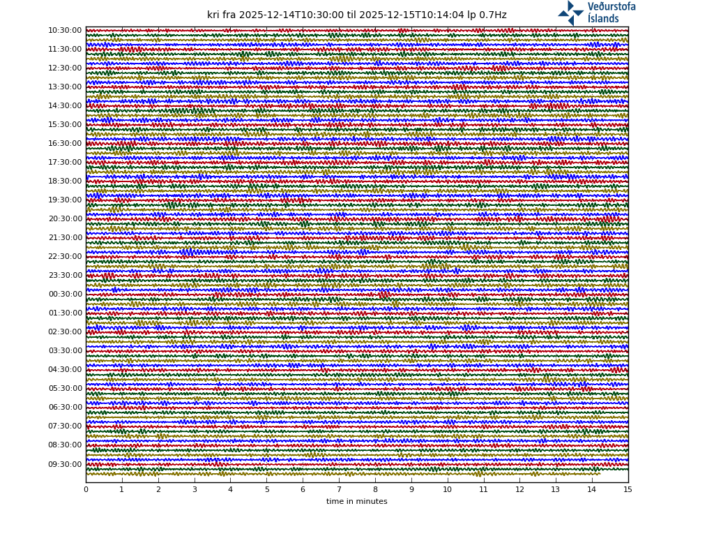
Updated image showing a far more interesting low frequency earthquake. The long LF coda indicates movement of volcanic fluids. Image by Icelandic Met Office.
Due to the size of the earthquakes associated with the swarm dykes can rapidly form towards the surface, and magma ascent ratios above 2km per day is possible, with even higher speeds as and if nucleation of volatiles start to set in.
Currently the IMO has not issued a bulletin concerning an upcoming eruption, but the University of Iceland’s Volcanology Department has made a risk assessment that is concurrent with what I wrote earlier today (14.48). There is also an Aviation Colour Code of Yellow in effect for Krysuvik, but I guess this is about to be amended to also include Fagradalsfjall.
It is good to remember that the current unrest is not new, I wrote about it back in 2017, so it is likely that this is a secondary emplacement (the first was very small though).
Unrest at Fagradalsfjall | VolcanoCafe
Conclusion

Volcanic eruption location risk assesment map from the University of Iceland. Image purloined from the University of Iceland, serious thanks for this beautiful map.
Using energy release modelling versus bedrock resilience figures it is quite easy to see that if the current earthquake swarm continues at these energy levels the rifting will become great enough to create dykes that will reach the surface.
Signs to look out for is Volcano-tectonic type earthquakes moving upwards, low frequency tremor bursts, tornillos, and onset of harmonic tremor (likely in that order). So far none of this has been seen except for VT-signals that have remained stationary at depth.
The GPS-trajectories is also showing an intrusion at depth with a hypocenter of 6km slightly NE of Fagradalsfjall, the trajectories is though based on limited datapoints so far. The intrusion is there, but the location could very well be off.
So, what would an upcoming eruption look like if it would occur? Historic data and judging from pre-historic eruptions we can expect something similar with the Krafla Fires. Episodic outbursts of mainly effusive lava fountains and lava flows.
So, if an eruption happens, do not expect something overly big (for being in Iceland), but it could still be a bloody nuisance if it is moving towards Grindavik or other populated places.
This will be updated if and when things progress.
CARL REHNBERG
Edit: Post updated with nicer LF earthquake signal image.
Edit 2: Added another one thousand earthquakes to the swarm.
Edit 3: New image with even more interesting coda. I will leave new pictures down here for the time being to give a progression line. This one is yet another LF, this time from KRI-station:

Image from Icelandic Met Office.


Iceland is hoping to open the tourist industry again later this year. An eruption astride the roads to the airport would complicate things a bit.
Not that much, Icelanders are pretty good at making volcanoes do what they wish. So, a new road would be up quickly.
For reference, they pretty much used the Heimaey eruption to improve the harbour by hosing it down with water. Lavasculpting.
There are two plausible routes from the capital to Keflavík, and although the southern road really wouldn’t be my choice, I think at least one would likely remain open. I was thinking more of ash fall, noxious fumes, and the like.
There will be very little ashfall, and the size would not be overly big, so gas should not be an insurmountable problem.
Good! Then I can visit every day. 🙂
If any lava flow reached the sea, there would be tephra.
So if a new road and viewing area in the Fagradalsfjall area opens up, we can expect the Icelanders to induce the volcano to erupt pretty soon? 🙂
There is a lovely (jeep) road there. I have just been there once.
Friday
26.02.2021 22:38:43 63.923 -22.217 5.1 km 4.8 99.0 3.0 km SW of Keilir
My cat complained about that one.
You have a purrsmeowmeter?
:). Yes. He had a lot to say about this morning’s 5.2 as well.
It would probably have been funnier if I had said “Seismeowmeter”. Anyway, good luck, stay safe and enjoy the fireworks if it comes to that.
Perfect tourist eruption, nice lava flows and no ash, and right next to the airport so easy access. Too bad I live almost antipodal to Iceland 🙁
It is interesting though we have two arguments, this one giving possibility for an eruption within the next few weeks and other comments for things being years or decades down the line. I guess given how close it is to Reykjavik even if it is a tiny 2 hour eruption there will be a swarm of people out to watch it so we get a lot of video 🙂
Think that might depend on how big any rifting episode is …
There have been some large eruptions in that area (volume-wise with tephra if the lava reached the sea) in the thirteenth century. It could get interesting; you would not want to be downwind from them.
There was an explosive VEI4 eruptions near Reykjanes tip, not Krisuvik. Yes, 13th century. But there were some large lava eruptions near Krusuvik.
Think any eruption there could have an explosive phase if lava met water.
If a fissure opens up far enough out that at least part of it is under the sea, things could get messy for a while. The same if a fissure extends underneath a lake, too, but the lakes in that area tend to be between the fissure swarms, rather than on them, so that would be less likely.
Any lava flow reaching the sea would be giving up limited amount of tephra as it creates pillow lava upon water contact. The one at Reykjanes Volcano was different since water got into the volcanic plumbing itself and that in turned caused tephra to form.
And in regards of size, it will be comparatively small for being in Iceland since the plume only has limited influence out there. But, small is a relative thing, if you compare with most volcanoes and stand next to it, it will be pretty massive experience.
From my journeys and hikes in the Krisuvik and Fagradalsfjall, I would expect an eruption to start with a VEI2 ash phase and then turning into lava fissures. Why an initial ash phase? Because Fagradalsfjall is older rock than Krisuvik, and when I was there, the signs were of older Holocene eruptions, unlike Krisuvik. So magma would have to break through the older crust. There is also considerable surface water in the region. Its an unpopulated area.
If lava goes southwards, it would make an amazing tall lavafall. The regions has quite a few amazing looking frozen rocky lavafall fields, due to high cliffs. To the north the slopes are much more gentle.
I still dont think this is it. I think we will see intrusions but no eruption. Reykjanes tends to have these patterned big EQ swarms running from west to east.
I think Oraefajajokull, Grimsvotn and Askja are much more likely to be next Icelandic eruptions. Why? Because most eruptions in Iceland happen near the center of the hotspot/plume, especially when plume activity is peaking.
Grimsvotn will be the next eruption, probably some point in the middle of this year and very likely when its caldera lake drains and decompresses it. Its a 50/50 whether it is big though, 2011 was a big eruption and most eruptions are small, but there could have been a lot of magma intruded in the decade since 2011 so that might lead to something bigger. Maybe if the lake drains out completely the eruption might get an effusive stage too.
Hekla is probably going to erupt this decade too. It changed in the 20th century, the volume of lava erupted basically doubled from the long term average abd eruptions became more frequent and also more mafic basaltic abdesite instead of straight andesite, the supply rate increased. Hekla has only a deep chamber like Etna, so it probably wont show any local inflation, and that also probably means its next eruption will be sudden and violent, maybe a bit more seismic than in 2000 but still very sudden.
I actually do have questions about the so called plume peak though, because there has only been 1 eruption in the last 10 years and little clear activity. Is it related to frequency of eruption or volume of eruption?
The plume peak comes from the fluctuations in number of icelandic eruptions, which peaks every 150 years or so. But this fluctuation is almost entirely due to Grimsvotn. I think we are looking for something that mainly affects this volcano. It may not be the plume activity: the cause may be closer to the surface.
Icelands propensity for cycles is what is making the place so interesting.
The most famous of those cycles are the magmapulse cycle that is about 150-170 years apart, and the Dead Zone rifting cycle that is 250ish years apart. (we are entering both right now).
But there are other less famous like the Vestmannaeyjar cycle, The Krafla cycle, and so on. And the intriguing part is that they all tend to have different cyclic rates.
Reykjanes is almost pure MORB-magma, so a plumepulse will not affect it overly and is not known to be related cyclewise with the Rykjanes-cycle that is really long, about 1000 years beginning with up to 300 years of on and of eruptions and then 700 years of naptime.
With at least 3 (possibly 4) cycles starting at the same time we indeed live in interesting times. 🙂
The first one (150 years) is the one where the statistics come from Grimsvotn. As you say, it does not extend to Reykjanes. I am not convinced it is a magma pulse: there could be other causes. (Nor can I exclude a magma supply cycle.) In the dead zone, the time scale comes from the rifting rate of a few cm per year, and eruptions tend to happen when it reaches some critical size. For the other cycles, they are more like a typical recurrence time of earthquakes – indicative but you can’t predict when the next event will be.
Its actually a good point, Albert.
There has been an averaged 130-150 year cycle of frequency of Icelandic eruptions, dominated by Vatnajokull eruptions. However, there can be simple coincidences.
For instance, there were periods of high activity in Iceland in the late 1800s and early 1900s, and this happened as Grimsvotn and Bardarbunga had several eruptions. It also correlated with major eruptions from Askja, but that might have been a concidence.
In early 1700s (especially in the 1720s), there was again a period with high activity from Grimsvotn and Bardarbunga (as far as I remember), and Oraefajokull and also Krafla fires, all within a very short of time. Those two might have been coincidences.
As we go further back in time, there still seems to be cyclical fluctuation of eruption frequency and intensity, but data becomes scarcer.
As Carl said, there can be different cycles, from Krafla, from the dead zone, from Reykjanes, etc.
All volcanic cycles are semi-regular at best, and prone to random variations and unexpected changes in patterns.
To the best of our knowledge there is good evidence for new plume magma pulse. It fits the 130-150 year theoretical cycle. New fresh deep magma erupted in Grimsvotn, for the first time in at least hundred years. Holuhraun also erupted primitive fresh magma. And I wouldn’t be surprised if Fimmvorduhals (in 2010) was the same case.
In addition to this, there has been a general uptick in magmatic intrusions in Iceland and restlessness from different volcanoes across Iceland. But often this does not mean eruptions right away.
It sounds like maybe there is some alternation of the plume among the volcanoes, just like in Hawaii.
Think what we are seeing at the moment is largely tectonic on the Reykjanes Peninsula – a bit of the plate boundary unlocking. If this does produce an eruption, we should seen SW-NE trending earthquakes as a fissure opens up. Although with this level of seismic activity, spotting the quakes relating to a fissure may be challenging.
Nice to hear from you, Carl. Thanks for the info!
The Famous Blue Lagoon is a possible casualty. And Grindavik, where the restaurant, Café Bryggjan, serves a lobster bisque worthy of note, is also in the path of potential doom. I start drooling thing about it. Hope they make it through this, but I’m thinking this might be big.
The thinking of Icelandic volcanologists puts the most likely location for erupting fissures a bit further east, around Fagradalsfjall. Lava flows from there are unlikley to be a threat to Grindavík or the Blue Lagoon but could disrupt the main road. See map here:
Thanks for the article Carl.
Reykjanes peninsula and the Husavik-Flatey Fault have been showing unrest above average past year. The latter is silent now.
Do you know of a relationship between unrest in transform faults and volcanic activity in other parts of Iceland in the past?
GPS Nylenda is remarkebly consistent in its movement northwest the past year in contrary to the period before… Why could it be so? Just plate pulling? It is local! I would have expect other stations further away to show something similar.
Thanks!
Hello Rob!
Yes, there has been historic volcanic activity in Iceland before. The most obvious example is Hekla that is situated at the end of the SIFZ.
Now over to NYLA, first of all, that one is on the other side of the MAR. So it is moving opposite to the ones on the southern side of the MAR.
Best fit solution is that it is affected by the two intrusions that has happened in the last year, the first one being the large at Thorbjörn, and the second smaller more local at Reykjanes Volcano.
In other words, it is being pushed away from Thorbjörn at a rapid clip.
It is also good to remember that different parts of Iceland is not as “solid” as other parts. So some GPS-stations are placed on tectonic pieces that are less stable than others and thusly more prone to move about with less force.
I recall (vaguely, not sure, cannot check) that Nylenda started to move short time before the þhorbjörn intrusion.
Here is that chicken – egg question. Is Nylenda pushed away or is the plate pulling?
The pulling seem more plausible, if the transform faults are activeand act as some kind of a possible (but not very reliable?) precursor of volcanic activity in evz wvz.
Nope, it is always the egg 😉
The egg in this case is the plume.
It is currently driving the plate tectonic separation of the North American continent and Eurasia.
So, in the end it is all push and no pull in general. Locally it can be pull caused by the immense push, but it is the egg behind everything.
You can’t get rift spreading without pull. In this case the pull is far away, in the Pacific, but it is acting. You can see this because the rifting rate is the same over a large stretch of the north Atlantic, not just in iceland but also further south where there is no plume. (Carl will now point out that spreading rates north of Iceland are very low, which is also true.) The plume is pushing at an open door. Different effects play a role.
But pull comes in two different forms. In the Pacific, the subducting oceanic plate is pulling the entire plate down, and this requires rifting to replace the subducted crust. However, there isn’t much rifting in the north pacific, since the spreading rift itself was also subducted. Therefore, the Pacific is getting smaller as the subducted crust is not being replaced. This pulls in the continental plate, to replace the missing crust. This secondary effect of subduction is causing the pull on the Atlantic.
There are four forces that contribute: the pull from the sinking plate, the horizontal convection current in the mantle, the push from the rising mantle, and gravity on the height difference between the rift and the deep ocean. In Iceland the latter two are stronger than elsewhere and do contribute more. The main force acting overall on the north Atlantic is the pull from the pacific.
On Etna there is a lot of emissions from the northeast crater now, the past weeks pattern seems to have stopped though. Interesting if a paroxysm happens at the NEC, it had some fountains a few years ago but it hasnt had a proper paroxysm since the mid 90s, since then the SEC has taken over with episodes at the central crater in 2015 and 2016.
The tremor is still holding at the level between fountains from this past week though, not dropping off, so it seems poised to erupt again on short notice at any time.
Another 5-ish quake (IMO has it at 5.2 for now) this morning. This swarm shows no sign of slowing down yet.
It does, though, seem to be gaining a bit of focus. Initially, the stars were lined up along a fairly clear WSW-ENE axis; now, they’re clustered near Fagradalfjall.
This is a very intense swarm and acually looks like an eruption is comming If this continues… will resemble the Krafla fires
The Blue Lagoon is toast …
Will be buried under Aa lava and perhaps even under a spatter cone : ( the entire arera coud dissapear in minutes If the fissure fountains opens up there, acompanied by pheratomagmatic steam venting
If a vent opens under blue lagoon then it will become a much bigger lagoon, but also probably fill with lava afterwards, red lagoon 🙂
How much more can it take.
That is the million dollar question really.
We have just surpassed the historic 1933 swarm in regards of energy release. That one had 5 earthquakes ranging between 4.9 and 5.9M.
It is also worthy of note that in 1933 there was no rifting/volcanic cycle at Reykjanes Peninsula like there is now.
Right now the seismic activity seems to have “mushed up” poor Fagradalsfjall enough so that magma can move freely up to 4.8-4.6km depth.
That means that it is a question about what the magma pressure is from below, and how solid things are 4.6km and upwards.
If the magma pressure is high and the ground weak, then we are near the point of no return. If the ground above is solid and the magma pressure is low, then it would take quite a bit more.
Magma pressure being the really interesting part, we know that it was high during the seismic crisis at Thorbjörn.
GPS-trajectories over the next few days will give the answer to the available magma pressure.
Something I am wondering, the swarm is mostly tectonic but the quakes dont get located immediately, if a dike begins to rise and it rises rapidly, is the detection system fast enough to actually confirm the quake positions in time to resolve a dike as it forms?
The amount of VT vs Tectonic earthquakes is shifting now towards more VT.
Dykes are not that fast, a horizontal dyke is faster than one going straight up. The speed is determined by how resilient the bedrock is, and how high the pressure is. So between a couple of hundred meters per day up to a couple of km per day. As and when the magma reaches the point of volatile nucleation the speed can increase exponentially if the magma is rich in volatiles.
This magma is MORB so contains quite a bit less volatiles compared to the incredibly gassy Icelandic plume-derived magma.
Short answer, yes we have ample time to check the earthquakes as the dyke progresses. At least up to the moment nucleation starts and we all quietly say “fúkkúr”, because by then it will come up, and it will come up hard and fast.
Interesting, I did forget we would also see harmonic tremor and obvioys deformation if a dike was created too so looks like it wont be a sneaky eruption.
I did read that today there was unusually high amounts of hydrogen detected at Svartasengi, which I think is the place next to blue lagoon. No other magmatic gasses but we saw at Kilauea in December that isnt necessarily a good warning, and that is at Kilauea which erupts all the time not a place which hasnt erupted in 800 years, there must be a good solid lid after that long. Hydrogen would mean magma is reacting with water in a reducing environment.
If the ground breaks. Will it be a big eq? Is there someone on the forum from Iceland? We need a volcano cafe reporter to live stream and report 24/7
It would be many discrete earthquakes that formed the dyke to the surface. So, it will most likely be continuing as now up until eruption starts (if it starts).
There is a load of locals on here, so do not worry about the live coverage. 🙂
A warning from the Road Authorities about a crack in the road “Suðurstrandarvegur” 8 km south of the M5.2 epicenter which occurred this morning at 8:02.
https://twitter.com/krjonsdottir/status/1365601449456132097
More than 6000 tremors are measured in the area since the devastated began.
27.2.2021
Updated 27.02 p.m. at 9.10am
At 08:07, an earthquake occurred at 5.2 magnitude, about 2.5 km NA of Mount Fagradals. The number of aftershocks has been measured.
The largest quake was felt in the south and southwest, east to Forests and north to Hvanneyri.
A total of over 600 tremors have been measured in the Reykjanes peninsula since midnight. It measured 9 tremors over the M3.0 in size. Of these nine, the largest M3.8 was at 2:30 p.m., and it was found in many parts of the Reykjanes peninsula, the capital and the West Country. Another tremor, of the size of the M3.7, was measured at 04:14 and was felt in Reykjanes and the capital area. The devastation is now mainly confined to the area between Mount Fagradals and Keilis.
These kinds of effects are not unique in this area, e.g. about five tremors of the size of the M4.9 to the M5.9 at Mount Fagradals on June 10, 1933.
https://www.vedur.is/um-vi/frettir/skjalfti-m57-a-reykjanesi?fbclid=IwAR0x1ZFIjWu2Ytw1qWiTDpHK3tjxMeubK1Yy0msOHQMDXRp9DYYdiA9LQUQ
@hjortur
Iceland has grown 6 cm in the last three days! According to geologists GPS measurements the continents have drifted up to 6 cm apart in the #earthquakeswarm since Wednesday.
https://twitter.com/hjortur/status/1365598139818901504
signs of a volcanic event perhaps comming up
You don’t get to be a continent without a little drama. 🙂
Can anyone explain the mechanism of why we have multiple M2 & M3 earthquakes during this swarm going on for days and days with earthquakes every 5 minutes? I’ve never seen anything comparable in earthquake swarms around the world – is it purely due to the tectonic setting – a mix of oceanic and continental transform/divergent?
I’d always seen as earthquakes as what had to give does, then there are adjustment aftershocks, and somewhere down the line another larger earthquake occurs where strain wasn’t released or was put onto by the previous quake.
Hello Andy,
It is build up stress due to ongoing rift proces, plates moving away from each other. Reykjanes is a transform zone with many smaller fault systems parallel. When one fault releases strain, another one builds up more, untill that one snaps too. And so one.
And as you said, after a larger eq, many smaller occur to adjust within the same fault.
Also the Tjörnes area north of Iceland is known for it intens swarms.
This is an older VC article from the dungeon which explains some more.
https://volcanocafe.wordpress.com/2013/04/02/how-rifting-occurs-in-iceland-explanations-regarding-the-recent-earthquake-swarm/
Thanks Rob, I was picturing much larger gaps between segments, not lots of transform sections in close quarters before it straightens out. Added to a magma mush in the area. Makes a lot more sense.
The stretching of iceland due to plate movement – is that liable to create an inland sea or rift valley at some point, or will it rise to fill the space?
Iceland is lifted up by the mantle heat below, and is 3-4 km above where it would have been without it. A mid-oceanic rift is a big bulge, with a 10-km wide valley at the top. The valley is the rift but it is not very deep. Iceland has the bulge but no real rift valley. To get a deep rift, you need to rift continental crust.
Looks like the earthquake activity at Reykjanes has slowed down a bit. Temporary lull, or did it run out of steam?
You guys are so lucky. Experiencing all of this mafic volcanism. Let’s not forget about taal though it has had 113 tremors. Don’t quote me on that my hardware is acting up. Hopefully we’ll see some nice eruptions from Iceland in the world in general soon!
Sorry Tallis Taal is also a mafic volcano…
You need to wait for something like this to happen in New Zealand. TVZ is tectonically very similar to Iceland but big eruptions there are all rhyolite 🙂
People and animals get used also to earthquakes. My friend and her cats, living close to Fagradalsfjall. The cats were in total pannic after the first 5.8 and aftershocks. Now they are calmly sleeping when +4 stars are shaking the house!!
Is there a live data feed for the water lake at Grimsvotn? It is reportedly very high, as high as it was in 1996. I dont know how deep the outflow channel is compared to the lake itself but if all of the water drains then that is probably what will set off the next eruption. Its also a much better chance for prediction, as such floods have happened before so precedent exists.
Also how deep is the water lake at Grimsvotn? The ice isnt very thick and even has open holes in it now but the lake is probably very deep now.
Check here:
http://brunnur.vedur.is/gps/grimsvotn.html
The graph “Hæðarbreyting í Grímsvötnum” is based on a gps placed on top of the ice in the lake, so it follows the lake level as it rises. Note that there is a gap in the data and that there seems to be a positive offset after the data returned. I think they probably dug the GPS antenna out of the snow and placed it on a higher pole.
Bear in mind that Grímsvötn is ready for an eruption and the lake level is ready for an overflow. If the eruption happens first it will without a doubt trigger a flood. If the flood happens first it may or may not trigger the eruption.
It is more that I think the size of the eruption could be influenced by the lake draining. If it erupts into the lake it will be pressure related, which could limit the size, and also removes that initial high pressure which means even a subsequent draining of the lake while the eruption is ongoing might be somewhat unimpressive, the flood would likely be much more interesting.
If instead, the flood happens first, then you decompress the entire magma chamber at the same time within a short time period. The high gas values suggest the magma is shallow, the depth of the lake is probably the only thing stopping an eruption at all right now. This scenario I think is much more likely to give us a big eruption. I dont think we will get higher than another VEI 4 though, the eruption would vecome effusive after that, a ring fault fissure with tall fountains and maybe very hot lava like Kilauea Iki. Maybe it will even create a big enough structure that ice wont bury it afterwards, and we can call it Grimsbunga 🙂
One can dream.
Another M4+ to start of Sunday. Hobbes decided to be a lap cat for a while when that one started. 🙂
IMO has it at a 5.1 at 00:19
Never mind. A 4.7.
Trust the seismeowmeter.
😁
http://www.ct.ingv.it/index.php/monitoraggio-e-sorveglianza/segnali-in-tempo-reale/video-sorveglianza-vulcanica-etna
New eruption on Etna again!
Most intense paroxysm so far
Are you sure? The lava flow is not as extensive as the last few, I watched it through the skyline webcam live and it also didnt have any far fallout or pyroclastic flows, all of the fallout was on the cone.
Yes this was an insane paroxysm! Sent a hot tephra fountain kilometers up, its intensity is why it lasted so shortly. INGV thermal cams where totaly filled by hot materials. As well as pyroclastic sourge from fountain fallout on visible light webcam
https://m.youtube.com/watch?v=skWCU1aGryE&feature=youtu.be&fbclid=IwAR1T9f6sYYm-RDU6xRST4LMhFNHnojLKFXssgqyTKM8BTdXTZDYsAxp6D14
Full video of the paroxysm
It’s just incredible!
I don’t know, it seems the February 22 paroxysm was the strongest, the following two have also been very intense but not quite as much, this I get from looking at the tremor signals. Repose periods are growing longer too.
It seems activity is weakening, which is not surprising, it would be impossible for any volcano to keep what Etna has been doing in the long term. During the first 6 paroxysms the rate of supply to the southeast crater conduit must have briefly reached the equivalent to about 1 km3/year, as I’ve said, impossible to keep in the long term, the activity is now dying out. The fountains may have reached such an intensity that they triggered a short lived surge in supply from the top down.
Todays paroxysm was the strongest According to INGV: watch the timelapse
Tremor is still very elevated on Etna and comming from a constant concentrated
source .. a few 100 s meters below the SEC complex.. possible that shallow magma is degassing there or filling a forming something akin to a chamber.
I would like to know the volume. My guess is the combined total for this series of 8 is probably a significant volume eruption, all of them except the most recent created lava flows that reached the bottom of the Valle del Bove about 4 km away, and all in little more than an hour. The last didnt but created a 10 km eruption column, it was not long enough to make a bigger flow but probably could have if it lasted longer.
If though each fountain was erupted at 500 m3/s and the combined total is so far about 10 hours that is a volume of 18 million m3. That sounds too low to me, the biggest fountain could easily have been double that rate, in fact most of them could. I have seen a possibility that the fountain on the 22nd was even taller than the initial estimate, and an all time world record… 🙂
Here are the lava flow volumes of the first 4 episodes:
Assuming all 7 episodes have had about the same volume then that is about 22 million m3 of lava erupted, almost the yearly supply of Etna.
Start watching at 2:21 https://www.youtube.com/watch?v=zQPB6NjgjPM
Some Etna flows are very fluid. probaly happens when it erupts at over 1130 C. But most never forms any pahoeho, high visocisty and high eruptive rates
https://www.youtube.com/watch?v=9zMZVdjjP6k
Here is a beautyful video of LGM vegatiation thats escaped the hot lowlands up on Etnas slopes… looks very scandinavian up there in biology. This area was totaly demolished in the 2002 flank eruption
Wow!
https://twitter.com/aarcidia/status/1366103692974428170?s=09
Another view on Etna this morning.
It seems to be seriously rocking an rolling now – between 2 and 3 ‘stars’ (mag 3+ quakes) per hour.
The data is a bit noisy, but the Krýsuvík GPS plot is probably worth watching: https://notendur.hi.is/~hgeirs/iceland_gps/KRIV_100p.pdf
@Lindadogg92
10,000 earthquakes since Wednesday #icelandquakes #iceland
11:07 AM · Feb 28, 2021 from Iceland
https://twitter.com/Lindadogg92/status/1365981945566547971
Is it going to be a eruption.? Maybe we can put some money on ladbrooks or some of those betting sites. I bet its not going to erupt. Then I don’t get disappointed if nothing happens. 🤔
GPS meters placed at Mount Fagradals
https://www.mbl.is/frettir/innlent/2021/02/28/gps_maelum_komid_fyrir_vid_fagradalsfjall/
https://en.vedur.is/earthquakes-and-volcanism/earthquakes
Earthquakes on the Reykajnes Penninsula is increasing…the longer it goes on the more chance it is for it to transform into a magmatic swarm
The latest M3+ earthquakes are clustering very close to Keilir, and form a line well away from the transform fault extending northeast. This can go either way, but if there is any magma available this is providing an ideal route for it. The larger quakes range in depth from 8 to 3 km.
A brief update.
The GPS network is now showing a fairly broad uplift centering at two locations. The first is at Krysuvik, and the second is obviously along the Fagradalsfjall/Keilir centre of earthquake activity.
The earthquakes are nicely codad in the LF and current location of volcanic fluid signals are at around 4.1km depth, 500 metres less compared to yesterday.
This means that if volcanic fluids continue to rise upwards an eruption might occur in 5 to 12 days. It is still a big IF obviously, and is depending on continued heavy seismic activity.
Where can I find this GPS data?
This may be what you’re looking for: https://notendur.hi.is/~hgeirs/iceland_gps/rnes/rnes_100p.html
Magma will look for the easy way out.
Fagradalsfjall has quite old rock (not a good exit).
Keillir has younger rock and the plateau around has less altitude (making it an easier escape, by going a few kms northwards)
Further east, in Krisuvik, there has more recent eruptions (so it’s also a very good exit point for magma).
Interesting next few days.
The 6cm spread facilitates an eruption considerably.
It’s all now dependant in how much pressure is magma pushing through.
I know Fagrad is only a small volcano in terms of height above sea level. What role do gas laws play here in terms of explosiveness. Take gunpowder for instance, if you were to light a cartridge on the ground in the would just fizzle. Yet when you put it down the barrel of a musket or a cannon, it is the expansion of the gasses that make so powerful. Given that Fagrad is, I assume, sealed could the expansion of gasses and build up of pressure create a bigger bang than what would normally be expected?
My knowledge of volcanoes is somewhat limited.
Do you predict a eruption Carl?
@Vedurstofan
At 19:01 there was an #earthquake around M4.7 about 1.5 km SW of Keili.
7:13 PM · Feb 28, 2021
This one felt long a long roll. The others today felt like shutters followed by swaying.
I live 20km from the swarm.
Large ammounts of seismic activity is present under Etnas SEC cone…
I think that a really large summit event is about to happen…the supply of Etna can be so large now that it can form a large terminator eruption ( km3 sized ) that puts Etna to sleep for a while. Woud not supprise me at all if she does something really big soon
In the words of Maximus Decimus Meridius, “Are you not entertained?!”
What makes you think that there is enough flow that could give Etna a VEI3-4?
Not a high VEI, a big effusive eruption like fissure 8 or Holuhraun. It isnt especially common but Etna has done these in the past, with the most obvious example being 1669. Theres been a lot of research into the eruptive cycles of Etna and since the 1940s it has increased in average yearly eruption rate by an order of magnitude, to the point that today it is second only to Kilauea in annual productivity which is a big deal for a volcano that isnt fed by a mantle plume. The amount of activity now is also very high, not only rapid paroxysms in short succession but some of the most powerful on record.
Also technically speaking this recent set of eruptions is already a VEI 3, and probably has the intensity of a 4.
Etna image taken with the ASTER camera on the TERRA satellite, Feb 26
Is https://en.vedur.is/earthquakes-and-volcanism/earthquakes/ not working for anyone else? I’m just getting an error message.
Yeah, it is down for me as well
RUV reported a problem at IMO: https://www.ruv.is/frett/2021/02/28/vefur-vedurstofunnar-liggur-nidri
Nevermind, just started working again.
@krjonsdottir
The most intense earhquake swarm on the Reykjanes Peninsula at least since I was born..
The animated gif shows the activity 24-28 February.
@Vedurstofan #earthquake #monitoring
Yet another big quake on the Reykjanes
Monday
01.03.2021 01:31:37 63.925 -22.210 3.4 km 4.9 99.0 2.6 km SW of Keilir
Here is a nice video of today’s lapilli rain from Etna. With footage of actual rocks falling from the sky.
Very impressive. 2021 is year of action everywhere.
https://m.youtube.com/watch?fbclid=IwAR3xYPtge17aPQ12cGl9Lb5IccuzkC8U0IfbITV6HN22u_IH9fZPeD6wM2Q&v=otykuBpWqFA&feature=youtu.be
Fun video unseen footage for me
4:37 – 4:45 Nyiragongo is very very fluid very little fragmentation in the spattering.
But this ultra – alkaline melt is defentivly much cooler than normal basalts I think. But it coud be the camera expousre, but Nyiragongo is almost certainly alot colder than Holuhraun and Hawaii. Makes sense with a melt like Nephelinite thats produced with so little partial melting
Alkali basalt is formed from less melting than tholeiite basalt, so it sort of by necessity is going to be a bit cooler. Nyiragongo is hot for an alkaline volcano. Nephelinite also is a mafic rock but not an ultramafic rock, it has low SiO2 but also low Fe and Mg, it is the ratio of those that makes a rock ultramafic or not. Many komatiites actually have around 50% SiO2 but much higher Mg than tholeiite basalt, at least 18% MgO by weight. Kilauea is usually around 8%. Theres also some other stuff but that is the most important bit.
The very hot lava erupted in episode 4 of the Kilauea Iki eruption is the closest we have gotten to this, it was 47% SiO2 and 15% MgO and was measured at about 1210 C with an optical pyrometer, a device which typically underestimates by about 100 C. That is probably the hottest lava we have seen.
Its true that Nyiragongos Nephelinites are formed by the most minuet the smallest ammounts of partial melting. Its an ultrabasic rock….not ultramafic.
Nephelinite is perhaps the rarest extrusive sillicate lava rock in the solar system.
Most Nephelinites are limited to slow continetal spreading centers and weakest oceanic hotspots. I haves rocks and sand from Nyiragongo, Im very happy beacuse its very rare stuff indeed. The plutonic forms of Nephelinites are called Ijolites, another exceedingly rare intrusive rock. Nyiragongos deeper magma chambers are perhaps encased in complexes of ultrabasic Ijolites.Ijoltes can be found 200 km from my home, If I melt them with fathers cutting welder… I will make my own Nephelinitic glass.
Nyiragongos sillica content is so very low, that it rarely forms peles hairs, not enough sillica glass polymers in it. The viscosity for Nyiragongo is insanely low, they measured the lava lake in 2017, and is one of the lowest viscosities thats ever been measured for any sillicate magma.
Kilauea is perfect for Peles Hairs.. it can be as fluid as Nyiragongo and contains alot more sillica dixode, when it fountains and sloshes it gets spunned by the wind into glass wool.
Peles tears and lava dropets are common among Nyiragongos lava lake shores as well as thin glassy pancakes of splashed out lava, but not alot of peles hairs.
The peles hairs thats been found at Nyiragongo are very long and steel grey quite diffrent from the golden hawaiian stuff!
But I think this is a VC Bar topic brb…
The low low Fe and Mg in Nephelinites togther with absence of any sillica rich minerals
Lowers the melting pioint and lowers the visocisty enromously at higher temperatures than most other alkaline magmas, probaly the reason why Nyiragongo displays extraodinary low viscosity at temperatures lower than Iki
https://youtu.be/90XFpu-65JY
0:49 – 1:02 might be the episode 4 fountain, there was no high fountaining like the other episodes.
This video is one of the things that set off my interest in volcanoes 🙂
1:14 – 1:22
Simply wow so fluid Kilaūea Iki was! Thats similar viscosity to Nyiragongo well below 10 pas. In this case the Thoelite Basalt is very hot ( 1280 C ) and that breaks down the sillica chains. Almost turbulence flowing. The spinning whirrpool over the drainbacks in Iki is also signs of very low viscosity among Kilauea summit lavas
Nephelinite is an ultrabasic rock
Sillica can be as low as 35% the lowest sillica of all sillicate magmas on the planet, certainly one factor of why Nyiragongo displays souch very low viscosity, togther with high temperatures. Nyiragongos lack of sillicon dioxide means very little polymerisation. Very very low viscosities been measured in Nyiragongos lava lake, one of the lowest, perhaps the lowest ever measured
But temperature is just as important, maybe more than sillica when we gets up to well over 1200 C basalts. Kilaūea Iki displayed very low viscosities
Komatites are the most fluid earthly lavas. The prehistoric 1650 C Komatites flowed like liquid iron slag or even like water! looking like liquid sunlight erupting out of Hadean era volcanoes
At current Nyiragongo hovers at 36 to 37% sillica .. very very low
I think most known exposures of komatiite are pillow lava, so erupted deep underwater. Maybe at plumes you would have islands which erupted it though, but it was probably not a common rock to erupt on land. The abyssal ocean crust was probably komatiite back then though.
I guess probably the best modern comparison would be iron ore slag, its at least about the right temperature and you can sometimes see pahoehoe textures in it.
Did you check ot the guys other videos. I mean; have a look at this one!
Another M4 at Keilir
…
The raft separation of both fire and seismic activity
Among the things being examined is whether the devastation can now be more recent volcanic activity in the area. There has been no volcanic activity there since about 1200. “The volcanic activity also appears to come under scrutiny every few hundred years and last for several years. It is trying to determine whether such a whale is being distorted, but there was a lot of activity here at the beginning of Iceland, or about 10 to 15 eruptions in the early centuries of the settlement,” said Paul.
Thus, it has been about 800 years since the last volcanic activity, so no one would have to be surprised if volcanic activity were to pick up in the area soon. “It’ll come to that at some point. These rafts are both volcanic and seismic. That’s their uniqueness.””
https://www.mbl.is/frettir/innlent/2021/03/01/standa_stundum_i_nokkur_ar/
https://twitter.com/SotisValkan/status/1366380770328268800
And the unwrapped interferogram from #Sentinel1 data (descending track Feb 23 – Mar 01) Reyjkanes peninsula, Iceland. Ground displacement in line-of-sight (LOS).
Is it possible for one of the volcanocafe quake/gif gurus to map the quakes out with one of those depth/quake strength timelines for this swarm?
This was extremely helpful/useful in understanding the dike propagation during the holuhruan eruption.
Cheers.
Yes please, very useful for Eyjaf also.
Do you mean something like this? https://baering.github.io/
Try this one
http://brunnur.vedur.is/gps/multiplot-rnes.html
But be aware that the plot with depth has the depth axis inverted. Zero is actually at the bottom, not at the top.
The quakes have come from a range of depths, 3-8 km, but there is no clear progression.
Tks Albert, useful link
I recall a VC contributor making 3D plots of Ejaf and Hierro. Could follow spatial changes with time clearly.
Ah, thank you for pointing out the inversion of the axis. I’d been wondering about all those “deep” earthquakes and why no one was talking about their being volcanic!
The quakes around Keillir seem really shallow now.
Do they look wet?
Does anyone know ?
I had a look at volcano discovery and I am not noticing any major difference.
https://en.vedur.is/earthquakes-and-volcanism/earthquakes
Earthquake swarm is not slowing down… if this continues there is a chance it will turn volcanic
Any eruption near blue lagoon will not be supersized… probaly a small version of Krafla Fires
Mánudagur
01.03.2021 16:35:45 63,944 -22,150 0,1 km 5,1 99,0 1,1 km ANA af Keili
LF plot:
Another 5.1 at Reykjanes.
Monday
01.03.2021 16:35:45 63.944 -22.150 0.1 km 5.1 99.0 1.1 km ENE of Keilir